MULTIPLE SPECIES CONSERVATION PROGRAM … SPECIES CONSERVATION PROGRAM CONFORMANCE STATEMENT . ......
24
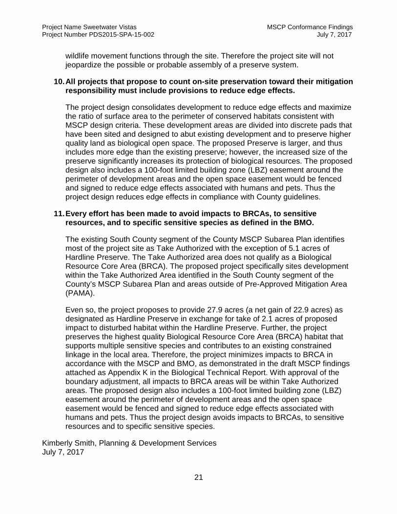
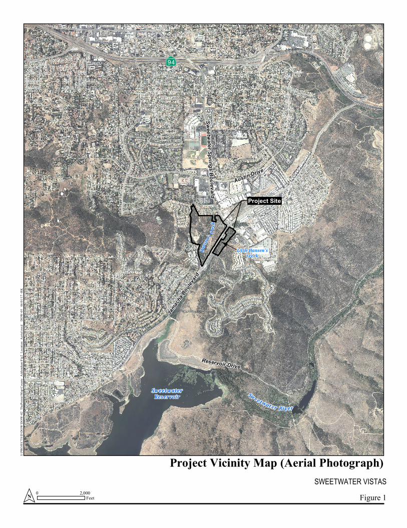
MULTIPLE SPECIES CONSERVATION PROGRAM CONFORMANCE STATEMENT For Sweetwater Vistas, PDS2015-SPA-15-002 TM-5608, ER 89-19-015I July 7, 2017 I. Introduction The approximately 51.9-acre project site is generally located north of Sweetwater Reservoir, south and west of State Route 94, and east of State Route 125 in the unincorporated community of Spring Valley in San Diego County, California (Figure 1). The project as currently planned will include the development of a new 23.1-acre master planned community consisting of 218 multi-family residential units and approximately 27.9 acres of biological open space. This project is a significant departure from the previously approved Specific Plan, which would have disturbed nearly the entire project site. Under the current proposed plan, the residential development to occur on the 43.4-acre parcel west of Jamacha Boulevard will be divided into three planning areas (Lots 1, 2, and 3). The 8.6-acre parcel east of Jamacha Boulevard, herein referred to as the “eastern parcel” will be placed in biological open space. A new road connecting Pointe Parkway will be constructed through the site. The project will also result in impacts from minor roadway improvements and a trail along Jamacha Boulevard, but these off-site impacts will occur entirely within existing disturbed habitat and developed (paved) roadways, and as such, will not affect biological resources. Areas of existing fire clearing and an existing County sewer easement (1.3 acres) were mapped as impact neutral. The project is anticipated to require a General Plan Amendment, Specific Plan Amendment, Rezone, MSCP Boundary Line Adjustment, Tentative Map, and Major Use Permit. The project site occurs within the boundaries of the adopted South County Multiple Species Conservation Program (MSCP) Subarea Plan, within both the South County Segment and Metro-Lakeside-Jamul Segment (Figure 2). Development has been specifically sited within Take Authorized Area and areas outside of Pre-Approved Mitigation Area (PAMA). Limited impacts will occur to 2.1 acres of disturbed habitat within Hardline Preserve. The project proposes preservation of equivalent or superior habitat for a Hardline Preserve boundary adjustment on site. The project preserves the highest quality Biological Resource Core Area (BRCA) habitat on site, including PAMA designated lands located on the east side of the project site, which supports multiple sensitive species and contributes to an existing constrained linkage in the local area. With the incorporation of the proposed conservation design and biological open space, the project will be consistent with the MSCP and Biological Mitigation Ordinance (BMO). The project would include two modifications to the MSCP: a Boundary Line Adjustment to transfer the Metro-Lakeside-Jamul portion of the site into the South County Segment, and a Boundary Adjustment to adjust the boundaries of the designations pursuant to the “like or equivalent exchange” guidelines for Preserve Boundary Adjustments within the MSCP Subregional Plan (August 1998).
-
Upload
nguyenhuong -
Category
Documents
-
view
217 -
download
1
Transcript of MULTIPLE SPECIES CONSERVATION PROGRAM … SPECIES CONSERVATION PROGRAM CONFORMANCE STATEMENT . ......

MULTIPLE SPECIES CONSERVATION PROGRAM CONFORMANCE STATEMENT For Sweetwater Vistas, PDS2015-SPA-15-002
TM-5608, ER 89-19-015I July 7, 2017
I. Introduction
The approximately 51.9-acre project site is generally located north of Sweetwater Reservoir, south and west of State Route 94, and east of State Route 125 in the unincorporated community of Spring Valley in San Diego County, California (Figure 1). The project as currently planned will include the development of a new 23.1-acre master planned community consisting of 218 multi-family residential units and approximately 27.9 acres of biological open space. This project is a significant departure from the previously approved Specific Plan, which would have disturbed nearly the entire project site. Under the current proposed plan, the residential development to occur on the 43.4-acre parcel west of Jamacha Boulevard will be divided into three planning areas (Lots 1, 2, and 3). The 8.6-acre parcel east of Jamacha Boulevard, herein referred to as the “eastern parcel” will be placed in biological open space. A new road connecting Pointe Parkway will be constructed through the site. The project will also result in impacts from minor roadway improvements and a trail along Jamacha Boulevard, but these off-site impacts will occur entirely within existing disturbed habitat and developed (paved) roadways, and as such, will not affect biological resources. Areas of existing fire clearing and an existing County sewer easement (1.3 acres) were mapped as impact neutral. The project is anticipated to require a General Plan Amendment, Specific Plan Amendment, Rezone, MSCP Boundary Line Adjustment, Tentative Map, and Major Use Permit. The project site occurs within the boundaries of the adopted South County Multiple Species Conservation Program (MSCP) Subarea Plan, within both the South County Segment and Metro-Lakeside-Jamul Segment (Figure 2). Development has been specifically sited within Take Authorized Area and areas outside of Pre-Approved Mitigation Area (PAMA). Limited impacts will occur to 2.1 acres of disturbed habitat within Hardline Preserve. The project proposes preservation of equivalent or superior habitat for a Hardline Preserve boundary adjustment on site. The project preserves the highest quality Biological Resource Core Area (BRCA) habitat on site, including PAMA designated lands located on the east side of the project site, which supports multiple sensitive species and contributes to an existing constrained linkage in the local area. With the incorporation of the proposed conservation design and biological open space, the project will be consistent with the MSCP and Biological Mitigation Ordinance (BMO).
The project would include two modifications to the MSCP: a Boundary Line Adjustment to transfer the Metro-Lakeside-Jamul portion of the site into the South County Segment, and a Boundary Adjustment to adjust the boundaries of the designations pursuant to the “like or equivalent exchange” guidelines for Preserve Boundary Adjustments within the MSCP Subregional Plan (August 1998).

Project Name Sweetwater Vistas MSCP Conformance Findings Project Number PDS2015-SPA-15-002 July 7, 2017
2
The project site supports 13 vegetation communities/habitat types: non-native vegetation, disturbed wetland, disturbed habitat, urban/developed, Diegan coastal sage scrub, non-native grassland, cismontane alkali marsh, mule fat scrub, southern willow scrub, tamarisk scrub, non-native riparian, Arundo-dominated riparian, and Eucalyptus woodland. Sensitive natural communities requiring compensatory mitigation for project impacts include Diegan coastal sage scrub, non-native grassland, and disturbed wetland. Such mitigation will reduce impacts to these resources to less than significant levels. Six special status plant species were confirmed as occurring within the project site during 2015 rare plant surveys: southwestern spiny rush (Juncus acutus ssp. leopoldii); graceful tarplant (Holocarpha virgata ssp. elongata); Munz’s sage (Salvia munzii); San Diego County sunflower (Bahiopsis laciniata); San Diego marsh-elder (Iva hayesiana), and ashy spike-moss (Selaginella cinerascens). None of these species are covered species under the MSCP. The project will preserve the entirety of the on-site populations of graceful tarplant, San Diego marsh-elder, and ashy spike-moss within biological open space. The project will impact relatively low numbers of southwestern spiny rush and San Diego County sunflower. This impact is considered less than significant because most of the on-site population of these two species will be preserved within biological open space. The project will impact three Munz’s sage and preserve the remaining eight that occur on site within biological open space. This, too, is considered a less than significant impact. Four special status bird species were determined to be breeding on the project site during 2015 surveys: coastal California gnatcatcher (Polioptila californica californica); Cooper’s hawk (Accipiter cooperi), least Bell’s vireo (Vireo belli pusillus), and yellow warbler (Setophaga petechia). In addition, four special status animal species were observed foraging and/or moving through or over the project site during 2015 surveys: monarch butterfly (Danaus plexippus), turkey vulture (Cathartes aura), northern harrier (Circus cyaneus), and red-shouldered hawk (Buteo lineatus). Coastal California gnatcatcher, Cooper’s hawk, least Bell’s vireo, and northern harrier are covered species under MSCP. The project will avoid and preserve within biological open space all occupied gnatcatcher breeding habitat on site and additional habitat for foraging and dispersal. The project will further avoid and preserve within biological open space all suitable and occupied breeding habitat for Cooper’s hawk, least Bell’s vireo, yellow warbler, monarch butterfly, and red-shouldered hawk. The project will preserve potential foraging habitat for turkey vulture and northern harrier. Impacts to special status bird species will be mitigated to less than significant levels through preservation of a biological open space easement, breeding season avoidance measures, fencing, and signs prohibiting trespassing. The project site supports reaches of Hansen’s Creek and Little Hansen’s Creek, in addition to an unnamed, man-made ephemeral drainage feature created by a storm drain outlet that serves as a tributary to Hansen’s Creek. These features would qualify as wetland and non-wetland waters of the U.S. subject to the regulatory jurisdiction of the U.S. Army Corps of Engineers (USACE) pursuant to Section 404 of the federal Clean Water Act (CWA); wetland and non-wetland waters of the State subject to the regulatory jurisdiction of the Regional Water Quality Control Board (RWQCB) pursuant to Section 401 of the CWA; riparian-vegetated and unvegetated streambed subject to the regulatory jurisdiction of the
Project Name Sweetwater Vistas MSCP Conformance Findings Project Number PDS2015-SPA-15-002 July 7, 2017
3
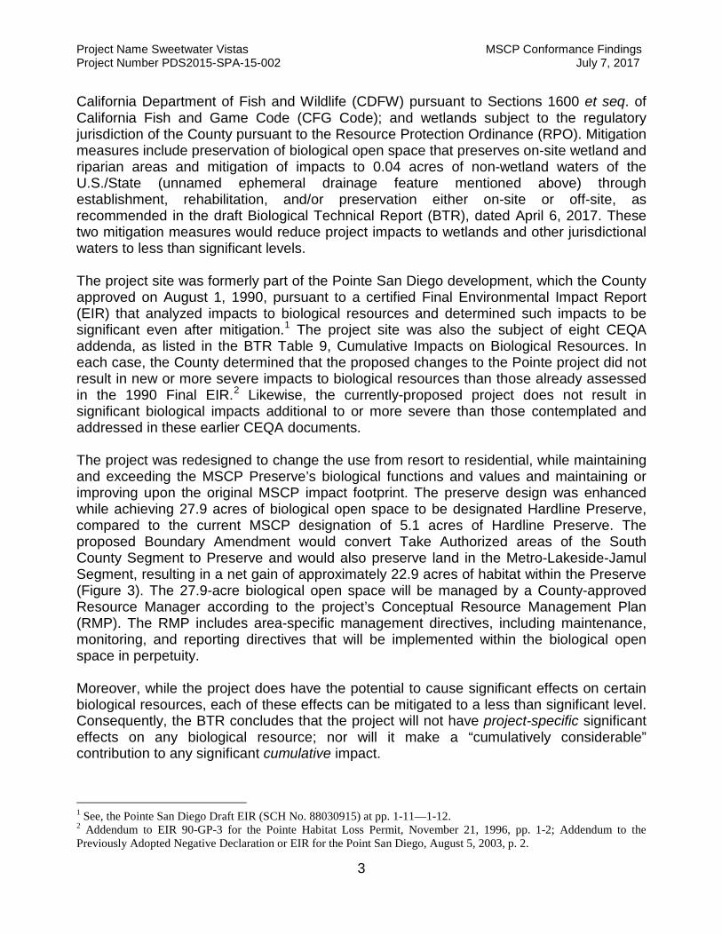
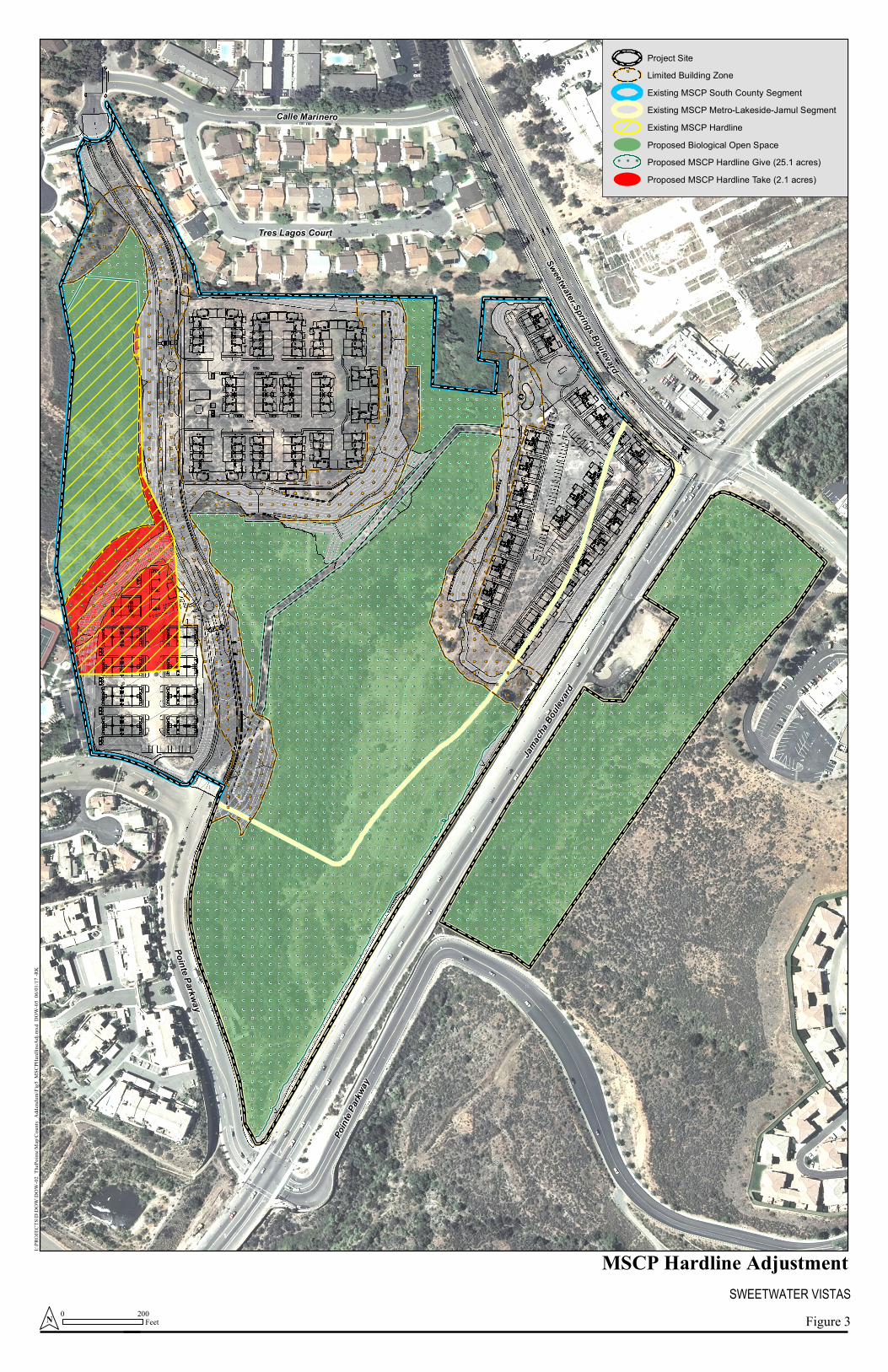
California Department of Fish and Wildlife (CDFW) pursuant to Sections 1600 et seq. of California Fish and Game Code (CFG Code); and wetlands subject to the regulatory jurisdiction of the County pursuant to the Resource Protection Ordinance (RPO). Mitigation measures include preservation of biological open space that preserves on-site wetland and riparian areas and mitigation of impacts to 0.04 acres of non-wetland waters of the U.S./State (unnamed ephemeral drainage feature mentioned above) through establishment, rehabilitation, and/or preservation either on-site or off-site, as recommended in the draft Biological Technical Report (BTR), dated April 6, 2017. These two mitigation measures would reduce project impacts to wetlands and other jurisdictional waters to less than significant levels. The project site was formerly part of the Pointe San Diego development, which the County approved on August 1, 1990, pursuant to a certified Final Environmental Impact Report (EIR) that analyzed impacts to biological resources and determined such impacts to be significant even after mitigation.1 The project site was also the subject of eight CEQA addenda, as listed in the BTR Table 9, Cumulative Impacts on Biological Resources. In each case, the County determined that the proposed changes to the Pointe project did not result in new or more severe impacts to biological resources than those already assessed in the 1990 Final EIR.2 Likewise, the currently-proposed project does not result in significant biological impacts additional to or more severe than those contemplated and addressed in these earlier CEQA documents. The project was redesigned to change the use from resort to residential, while maintaining and exceeding the MSCP Preserve’s biological functions and values and maintaining or improving upon the original MSCP impact footprint. The preserve design was enhanced while achieving 27.9 acres of biological open space to be designated Hardline Preserve, compared to the current MSCP designation of 5.1 acres of Hardline Preserve. The proposed Boundary Amendment would convert Take Authorized areas of the South County Segment to Preserve and would also preserve land in the Metro-Lakeside-Jamul Segment, resulting in a net gain of approximately 22.9 acres of habitat within the Preserve (Figure 3). The 27.9-acre biological open space will be managed by a County-approved Resource Manager according to the project’s Conceptual Resource Management Plan (RMP). The RMP includes area-specific management directives, including maintenance, monitoring, and reporting directives that will be implemented within the biological open space in perpetuity. Moreover, while the project does have the potential to cause significant effects on certain biological resources, each of these effects can be mitigated to a less than significant level. Consequently, the BTR concludes that the project will not have project-specific significant effects on any biological resource; nor will it make a “cumulatively considerable” contribution to any significant cumulative impact.
1 See, the Pointe San Diego Draft EIR (SCH No. 88030915) at pp. 1-11—1-12. 2 Addendum to EIR 90-GP-3 for the Pointe Habitat Loss Permit, November 21, 1996, pp. 1-2; Addendum to the Previously Adopted Negative Declaration or EIR for the Point San Diego, August 5, 2003, p. 2.

Project Name Sweetwater Vistas MSCP Conformance Findings Project Number PDS2015-SPA-15-002 July 7, 2017
4
Through the design process, the applicant analyzed a Project Alternative that would reduce Lot 2 on the north side. Although the alternative would slightly improve habitat connectivity and slightly reduce habitat impacts and Hardline Take, there are no significant impacts of the proposed project that would be reduced to less than significant by the alternative. After reviewing the project documents, visiting the site, and discussing the project in multiple meetings, the Wildlife Agencies provided their support of the proposed project on November 30, 2016. The proposed project was selected over the project alternative because it provides additional coastal sage scrub restoration and land being placed into conservation and management; it substantially improves upon the historic approved development footprint on the project site for The Pointe San Diego; and the open space primarily is expected to function for local movement by the coastal California gnatcatcher. Therefore, the alternative is no longer under consideration. In summary, the project would affect 23.1 acres of the approximately 52-acre project site. To the extent the project’s impacts to these 23.1 acres result in significant effects on particular biological resources – such as special-status species and jurisdictional waters – they can and will be mitigated to less than significant levels. The remaining 27.9 acres would be avoided and placed within biological open space to be managed in perpetuity for conservation purposes. Within the biological open space, an additional 3.2 acres of restoration and 0.4 acre of enhancement of native habitat would occur. Altogether, the project’s conservation percentage is 54 percent.
Project Name Sweetwater Vistas MSCP Conformance Findings Project Number PDS2015-SPA-15-002 July 7, 2017
5
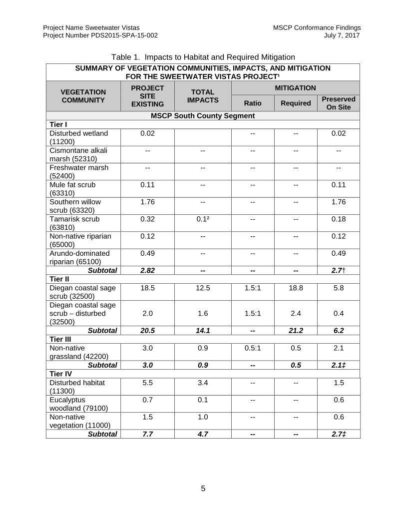
Table 1. Impacts to Habitat and Required Mitigation SUMMARY OF VEGETATION COMMUNITIES, IMPACTS, AND MITIGATION
FOR THE SWEETWATER VISTAS PROJECT¹
VEGETATION COMMUNITY
PROJECT SITE
EXISTING TOTAL
IMPACTS MITIGATION
Ratio Required Preserved On Site
MSCP South County Segment Tier I Disturbed wetland (11200)
0.02 -- -- 0.02
Cismontane alkali marsh (52310)
-- -- -- -- --
Freshwater marsh (52400)
-- -- -- -- --
Mule fat scrub (63310)
0.11 -- -- -- 0.11
Southern willow scrub (63320)
1.76 -- -- -- 1.76
Tamarisk scrub (63810)
0.32 0.1² -- -- 0.18
Non-native riparian (65000)
0.12 -- -- -- 0.12
Arundo-dominated riparian (65100)
0.49 -- -- -- 0.49
Subtotal 2.82 -- -- -- 2.7† Tier II Diegan coastal sage scrub (32500)
18.5 12.5 1.5:1 18.8 5.8
Diegan coastal sage scrub – disturbed (32500)
2.0 1.6 1.5:1 2.4 0.4
Subtotal 20.5 14.1 -- 21.2 6.2 Tier III Non-native grassland (42200)
3.0 0.9 0.5:1 0.5 2.1
Subtotal 3.0 0.9 -- 0.5 2.1‡ Tier IV Disturbed habitat (11300)
5.5 3.4 -- -- 1.5
Eucalyptus woodland (79100)
0.7 0.1 -- -- 0.6
Non-native vegetation (11000)
1.5 1.0 -- -- 0.6
Subtotal 7.7 4.7 -- -- 2.7‡
Project Name Sweetwater Vistas MSCP Conformance Findings Project Number PDS2015-SPA-15-002 July 7, 2017
6
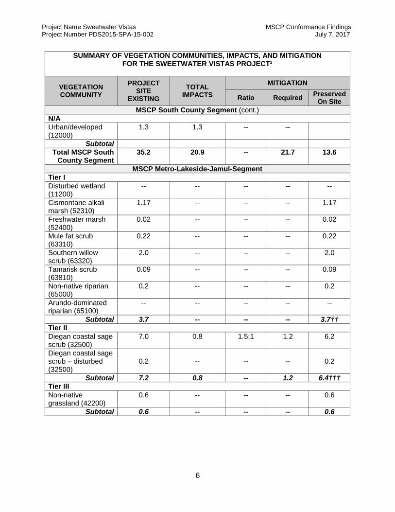
SUMMARY OF VEGETATION COMMUNITIES, IMPACTS, AND MITIGATION FOR THE SWEETWATER VISTAS PROJECT¹
VEGETATION COMMUNITY
PROJECT SITE
EXISTING TOTAL
IMPACTS MITIGATION
Ratio Required Preserved On Site
MSCP South County Segment (cont.) N/A Urban/developed (12000)
1.3 1.3 -- --
Subtotal Total MSCP South
County Segment 35.2 20.9 -- 21.7 13.6
MSCP Metro-Lakeside-Jamul-Segment Tier I Disturbed wetland (11200)
-- -- -- -- --
Cismontane alkali marsh (52310)
1.17 -- -- -- 1.17
Freshwater marsh (52400)
0.02 -- -- -- 0.02
Mule fat scrub (63310)
0.22 -- -- -- 0.22
Southern willow scrub (63320)
2.0 -- -- -- 2.0
Tamarisk scrub (63810)
0.09 -- -- -- 0.09
Non-native riparian (65000)
0.2 -- -- -- 0.2
Arundo-dominated riparian (65100)
-- -- -- -- --
Subtotal 3.7 -- -- -- 3.7†† Tier II Diegan coastal sage scrub (32500)
7.0 0.8 1.5:1 1.2 6.2
Diegan coastal sage scrub – disturbed (32500)
0.2 -- -- -- 0.2
Subtotal 7.2 0.8 -- 1.2 6.4††† Tier III Non-native grassland (42200)
0.6 -- -- -- 0.6
Subtotal 0.6 -- -- -- 0.6
Project Name Sweetwater Vistas MSCP Conformance Findings Project Number PDS2015-SPA-15-002 July 7, 2017
7
The findings contained within this document are based on County records, staff field site visits and the Biological Technical Report (BTR) by HELIX Environmental Planning dated April 6, 2017. The information contained within these findings is correct to the best of staff’s knowledge at the time the findings were completed. Any subsequent environmental review completed due to changes in the proposed project or changes in circumstance shall need to have new findings completed based on the environmental conditions at that time. Conformance with the County’s Multiple Species Conservation Program (MSCP) Subarea Plan, the Biological Mitigation Ordinance (BMO) and the Implementation Agreement between the County of San Diego, the CA Department of Fish and Wildlife and the US Fish and Wildlife Service is established only after the Wildlife Agencies have officially concurred with the two proposed MSCP boundary adjustments. Third Party Beneficiary Status and the associated take authorization for incidental impacts to sensitive species (pursuant to the County’s Section 10 Permit under the Endangered Species Act) shall be conveyed only after the project has been approved by the County, these MSCP Findings are adopted by the hearing body and all MSCP-related conditions placed on the project have been satisfied.
II. Biological Resource Core Area Determination
The impact area and the mitigation site shall be evaluated to determine if either or both sites qualify as a Biological Resource Core Area (BRCA) pursuant to the BMO, Section 86.506(a)(1).
A. Report the factual determination as to whether the proposed Impact Area qualifies as a BRCA. The Impact Area shall refer only to that area within which project-related disturbance is proposed, including any on and/or off-site impacts.
The existing South County segment of the County MSCP Subarea Plan identifies most of the project site as Take Authorized with the exception of 5.1 acres of Hardline Preserve. The portion of the site that is designated as Take Authorized area does not qualify as a Biological Resource Core Area (BRCA). The proposed project specifically sites development within the Take Authorized Area identified in the South County segment of the County’s MSCP Subarea Plan and areas outside of Pre-Approved Mitigation Area (PAMA) in the Metro-Lakeside-Jamul segment.
PAMA-designated lands, located along the eastern boundary, would qualify as BRCA; however all of these lands would be preserved. The Hardline Preserve area of 5.1 acres also qualifies as BRCA. The project proposes take of 2.1 acres of proposed impact to disturbed habitat within the Hardline Preserve. In exchange, 27.9 acres (a net gain of 22.9 acres) will be designated as Hardline Preserve. The project preserves the highest quality habitat that supports multiple sensitive species and contributes to an existing constrained linkage in the local area. Therefore, the project minimizes impacts to BRCA in accordance with the MSCP and BMO, as demonstrated in the draft MSCP findings attached as Appendix K in the BTR. With
Project Name Sweetwater Vistas MSCP Conformance Findings Project Number PDS2015-SPA-15-002 July 7, 2017
8
approval of the boundary adjustment, all impacts to BRCA areas will be within Take Authorized areas. No impact would occur.
i. The land is shown as Pre-Approved Mitigation Area on the wildlife agencies' Pre-Approved Mitigation Area map.
Pre-Approved Mitigation Area (PAMA) is mapped in the extreme eastern portion of the site. Approximately half of the 8.6-acre east parcel and a very small sliver on the west side of Jamacha Boulevard is designated as PAMA. This portion of the property qualifies as BRCA. Land designated as PAMA would be preserved as biological open space and thus would not be impacted by development.
ii. The land is located within an area of habitat that contains biological resources that support or contribute to the long-term survival of sensitive species and is adjacent or contiguous to preserved habitat that is within the Pre-Approved Mitigation Area on the wildlife agencies' Pre-Approved Mitigation Area map.
The existing South County segment of the County MSCP Subarea Plan identifies most of the project site as Take Authorized with the exception of 5.1 acres of Hardline Preserve. The portion of the site that is designated as Take Authorized area does not qualify as a Biological Resource Core Area (BRCA). The proposed project specifically sites development within the Take Authorized Area identified in the South County segment of the County’s MSCP Subarea Plan and areas outside of Pre-Approved Mitigation Area (PAMA). The project preserves the highest quality habitat that supports multiple sensitive species and contributes to an existing constrained linkage in the local area. The project is not located within an area that contains biological resources that support or contribute to the long-term survival of sensitive species. The project contains and is adjacent to PAMA land. The project will preserve the highest quality habitat on the site and provide connectivity between the designated Preserve in the western portion of the property and the PAMA lands in the east. Through preservation of biological open space and implementation of other mitigation measures, impacts to will be reduced to less than significant levels.
iii. The land is part of a regional linkage/corridor. A regional linkage/corridor is either: a. Land that contains topography that serves to allow for the movement of
all sizes of wildlife, including large animals on a regional scale; and contains adequate vegetation cover providing visual continuity so as to encourage the use of the corridor by wildlife; or
b. Land that has been identified as the primary linkage/corridor between the northern and southern regional populations of the California gnatcatcher in the population viability analysis for the California
Project Name Sweetwater Vistas MSCP Conformance Findings Project Number PDS2015-SPA-15-002 July 7, 2017
9
gnatcatcher, MSCP Resource Document Volume II, Appendix A-7 (Attachment I of the BMO.)
The project site does not support or contribute to a known regional linkage or corridor identified in the County MSCP Subarea Plan; however the site does contribute to an existing constrained archipelago or stepping-stone linkage in the local area. Even so, the project preserves the highest quality habitat and maintains connectivity between Preserve in the western portion of the property and the PAMA lands along the eastern boundary in order to conserve existing wildlife movement functions through the site. Development is targeted in areas that do not occur along expected travel routes and that do not support high quality habitat. Therefore, the development area does not qualify as BRCA based on the regional linkage/corridor criteria.
iv. The land is shown on the Habitat Evaluation Map (Attachment J to the BMO) as very high or high and links significant blocks of habitat, except that land which is isolated or links small, isolated patches of habitat and land that has been affected by existing development to create adverse edge effects shall not qualify as BRCA.
The existing South County segment of the County MSCP Subarea Plan identifies most of the project site as Take Authorized with the exception of 5.1 acres of Hardline Preserve. The Take Authorized area does not qualify as a Biological Resource Core Area (BRCA). The project proposes take of 2.1 acres of proposed impact to disturbed habitat within the Hardline Preserve. In exchange, 27.9 acres (a net gain of 22.9 acres) will be designated as Hardline Preserve. The project preserves the highest quality habitat that supports multiple sensitive species and contributes to an existing constrained linkage in the local area. Therefore, the impact area does not qualify as BRCA based on the Habitat Evaluation Map criteria.
A significant portion of the intact habitat within the site is designated as Very High in the Biological Mitigation Ordinance (BMO), most of which is included within Take Authorized Areas depicted on Attachment B (County MSCP Sub-Area Take Authorized Areas) of the BMO. Even so, the project has been designed to minimize impacts to the highest quality habitat on site that supports multiple sensitive species, including preservation of Tier I riparian habitat.
v. The land consists of or is within a block of habitat greater than 500 acres in area of diverse and undisturbed habitat that contributes to the conservation of sensitive species.
The project site is not located within a block of habitat greater than 500 acres; therefore, the project does not qualify as a BRCA under the large blocks of habitat criteria.
Project Name Sweetwater Vistas MSCP Conformance Findings Project Number PDS2015-SPA-15-002 July 7, 2017
10
vi. The land contains a high number of sensitive species and is adjacent or contiguous to surrounding undisturbed habitats, or contains soil derived from the following geologic formations which are known to support sensitive species: a. Gabbroic rock; b. Metavolcanic rock; c. Clay; d. Coastal sandstone
The existing South County segment of the County MSCP Subarea Plan identifies most of the project site as Take Authorized with the exception of 5.1 acres of Hardline Preserve. The Take Authorized area does not qualify as a Biological Resource Core Area (BRCA). Even so, the project preserves the highest quality habitat, including a band of Diablo Clay soils that run north-south within the Hansen’s Creek area. The proposed project specifically sites development within the Take Authorized Area identified in the South County segment of the County’s MSCP Subarea Plan and outside of the wetland and riparian areas of Hansen’s Creek. Therefore, the impact area does not qualify as BRCA under this soils-based criteria.
III. Biological Mitigation Ordinance Findings
A. Project Design Criteria (Section 86.505(a))
The following findings in support of Project Design Criteria, including Attachments G and H (if applicable), must be completed for all projects that propose impacts to Critical Populations of Sensitive Plant Species (Attachment C), Significant Populations of Narrow Endemic Animal Species (Attachment D), Narrow Endemic Plant Species (Attachment E) or Sensitive Plants (San Diego County Rare Plant List) or proposes impacts within a Biological Resource Core Area.
1. Project development shall be sited in areas to minimize impact to habitat.
The project focuses new development in three areas (Lots 1, 2, and 3) within areas that are designated as Take Authorized within the South County segment of the county’s MSCP Subareas Plan and have been predominantly previously developed or disturbed, thereby minimizing impact to higher quality habitat. The existing project proposes to conserve the highest quality habitat including wetland and riparian habitat (Tier I) and intact Diegan coastal sage scrub habitat (Tier II), designating 27.9 acres of land into the Preserve, a net gain of 22.9 acres of habitat preservation above the existing hardline preserve area of 5.1 acres. Additionally, within the biological open space, 3.2 acres of restoration and 0.4 acre of enhancement of native habitat would occur. Therefore, the project fulfills County guidelines to minimize impact to habitat.
2. Clustering to the maximum extent permitted by County regulations shall be considered where necessary as a means of achieving avoidance.
Project Name Sweetwater Vistas MSCP Conformance Findings Project Number PDS2015-SPA-15-002 July 7, 2017
11
The project would introduce new development onto the site with development concentrated in three areas (identified as Lots 1, 2, and 3). These development areas are divided into discrete pads that have been sited and designed to abut existing development and to preserve higher quality habitat as biological open space. Thus the project fulfills County guidelines to cluster development as a means of achieving avoidance.
3. Notwithstanding the requirements of the slope encroachment regulations contained within the Resource Protection Ordinance, effective October 10, 1991, projects shall be allowed to utilize design that may encroach into steep slopes to avoid impacts to habitat.
The proposed development area encroaches into a portion of steep slopes within disturbed habitat in the western portion of the site (Lot 2) in order to preserve higher quality habitat, including Tier I riparian habitat and relatively undisturbed coastal sage scrub, as biological open space. These higher quality coastal sage scrub lands are located in the northwestern portion of the site that supports rare plants, and the southeastern portion of the site. Thus the project satisfies county guidelines of encroaching onto steep slopes, when necessary, as a means of avoiding impacts to habitat.
4. The County shall consider reduction in road standards to the maximum
extent consistent with public safety considerations.
The project site includes a necessary extension of Pointe Parkway, which becomes Avenida Bosques through the project site. This road has been designed to abut proposed developments to minimize impacts and edge effects. Where it must traverse a small section of open space, the road is narrowed and adequate widths are provided on either side to facilitate wildlife movement. Therefore, County guidelines to reduce road standards consistent with public safety as a means to reduce impacts to sensitive species and habitats.
5. Projects shall be required to comply with applicable design criteria in the County MSCP Subarea Plan, attached hereto as Attachment G (Preserve Design Criteria) and Attachment H (Design Criteria for Linkages and Corridors).
The proposed project is in compliance with Attachments G and H. See below for additional details.
B. Preserve Design Criteria (Attachment G)
In order to ensure the overall goals for the conservation of critical core and linkage areas are met, the findings contained within Attachment G shall be required for all projects located within Pre-Approved Mitigation Areas or areas designated as Preserved as identified on the Subarea Plan Map.

Project Name Sweetwater Vistas MSCP Conformance Findings Project Number PDS2015-SPA-15-002 July 7, 2017
12
1. Acknowledge the “no net loss” of wetlands standard that individual projects must meet to satisfy State and Federal wetland goals, policies, and standards, and implement applicable County ordinances with regard to wetland mitigation.
The project would avoid and preserve all federally-protected wetlands that occur on site within biological open space; therefore, no impacts to federally-protected wetlands would occur. Thus, the project meets the “no net loss” of wetlands standard.
As a note, unavoidable impacts would occur to 0.03 acre of non-wetland waters of the U.S. subject to USACE jurisdiction associated with a nuisance-fed, ephemeral, unnamed tributary to Hansen’s Creek. The impacted non-wetland waters of the U.S. would also constitute non-wetland waters of the State subject to RWQCB jurisdiction. A total of 0.04 acre of unvegetated streambed subject to CDFW jurisdiction will be impacted within the same unnamed tributary. Impacts to jurisdictional non-wetland waters would be considered significant but mitigable. Mitigation through the establishment, re-establishment, rehabilitation, and/or preservation mitigation on-site within biological open space easements would reduce impacts to less than significant.
2. Include measures to maximize the habitat structural diversity of conserved habitat areas, including conservation of unique habitats and habitat features.
The proposed open space easement includes 27.9 acres of habitat, including 13 vegetation communities/habitat types: non-native vegetation, disturbed wetland, disturbed habitat, urban/developed, Diegan coastal sage scrub, non-native grassland, cismontane alkali marsh, mule fat scrub, southern willow scrub, tamarisk scrub, non-native riparian, Arundo-dominated riparian, and Eucalyptus woodland. The project site includes two seasonal drainages, including Hansen’s Creek and Little Hansen’s Creek and a slope that rises to west. Development has been situated in portions of the site that have predominantly been previously disturbed or developed. Thus, measures have been taken to maximize the habitat structural diversity of conserved habitat areas, including conservation of unique habitats and habitat features.
3. Provide for the conservation of spatially representative examples of extensive patches of Coastal sage scrub and other habitat types that were ranked as having high and very high biological value by the MSCP habitat evaluation model.
A good portion of the intact habitat within the site is designated as Very High on the Biological Mitigation Ordinance (BMO); however, the majority of this habitat is also designated as being included within Take Authorized Areas depicted on
Project Name Sweetwater Vistas MSCP Conformance Findings Project Number PDS2015-SPA-15-002 July 7, 2017
13
Attachment B (County MSCP Sub-Area Take Authorized Areas) of the BMO. Therefore, the habitat benefit of the proposed plan exceeds that of the existing Point Specific Plan. Even so, the project preserves the highest quality habitat on site that supports multiple sensitive species and includes Tier I riparian habitat. Of the 27.7 acres of coastal sage scrub (Tier II), including disturbed areas, 12.6 acres would be preserved. Thus, project design has provided for the conservation of spatially representative examples of extensive patches of coastal sage scrub and other habitat types that were ranked as having very high biological value.
4. Create significant blocks of habitat to reduce edge effects and maximize the ratio of surface area to the perimeter of conserved habitats. Subsequently, using criteria set out in Chapter 6, Section 6.2.3 of the MSCP Plan, potential impacts from new development on biological resources within the preserve that should be considered in the design of any project include access, non-native predators, non-native species, illumination, drain water (point source), urban runoff (non-point source) and noise.
The proposed project would introduce new development onto the site with development concentrated in three areas (Lots 1, 2, and 3). These development areas are divided into discrete pads that have been sited and designed to abut existing development and to preserve higher quality land as biological open space. The project design consolidates development to reduce edge effects and maximize the ratio of surface area to the perimeter of conserved habitats consistent with MSCP design criteria. The proposed Preserve is larger, and thus includes more edge than the existing preserve; however, the increased size of the preserve significantly increases its protection of biological resources. The proposed design also includes a 100 foot limited building zone (LBZ) easement around the perimeter of development areas and the open space easement would be fenced and signed to reduce edge effects associated with humans and pets. Thus the project design creates significant blocks of habitat to reduce edge effects and maximize the ratio of surface area to the perimeter of conserved habitats.
5. Provide incentives for development in the least sensitive habitat areas.
Development has been specifically sited in areas with developed (Tier IV) land or disturbed habitat. The most sensitive areas, including Tier I habitat and the highest quality coastal sage scrub located in the northwest and southeast portions of the site have been preserved within the proposed open space easement. Thus, the proposed project meets the County guidelines of focusing development within the least sensitive habitat areas.
6. Minimize impacts to narrow endemic species and avoid impacts to core populations of narrow endemic species.

Project Name Sweetwater Vistas MSCP Conformance Findings Project Number PDS2015-SPA-15-002 July 7, 2017
14
Least Bell’s vireo represents the only narrow endemic confirmed as occupying the project site. The project avoids and preserves within biological open space all occupied and suitable least Bell’s vireo habitat. Adequate setbacks and project design features are incorporated into the project to ensure no adverse indirect effects occur to occupied vireo habitat during operation of the project. Therefore, the project avoids impacts to MSCP narrow endemic species and would not impact core populations.
7. Preserve the biological integrity of linkages between BRCAs.
The project site does not support or contribute to a known regional linkage or corridor identified in the County MSCP Subarea Plan; however, it is situated along the path of a constrained archipelago or stepping-stone linkage in the local area, and supports wildlife movement including large mammals and sensitive birds. Development is targeted in areas that do not occur along expected travel routes and that do not support high quality habitat. The project maintains east-west connectivity between preserve areas and is designed conserve existing wildlife movement functions through the site. Thus, the proposed project meets the County guidelines of preserving the biological integrity and function of linkages between BRCA.
8. Achieve the conservation goals for covered species and habitats (refer to Table 3-5 of the MSCP Plan).
No MSCP covered plant species were observed on-site. There are four MCSP covered wildlife species observed on-site during 2015 surveys, including coastal California gnatcatcher, least Bell’s vireo, northern harrier, and Cooper’s hawk. The conservation goals of these species will be achieved through dedication of a 27.9-acre preserve, which will provide foraging, nesting, and dispersal habitat. More specifically, conservation of coastal California gnatcatcher will be achieved by preserving high quality coastal sage scrub and contributing to the habitat linkage between preserve areas ensuring they are conserved in a functional manner. Conservation of least Bell’s vireo will be achieved through preservation of riparian habitats, which provide nesting and foraging habitat, and maintenance of a no-net-loss of wetlands standard. Conservation of Cooper’s hawk will be achieved through preservation of riparian forest areas onsite, thereby providing nesting and foraging habitat. Conservation of northern harrier will be achieved through preservation of marsh and grassland vegetation communities, which provides foraging habitat. Additionally, the mitigation measures proposed – biological open space, limited building zones, fencing, open space signs, and breeding season avoidance – will adequately mitigate for any potential impacts to covered species and habitats. Therefore, the project meets the conservation goals of covered species and habitats.
C. Design Criteria for Linkages and Corridors (Attachment H)
Project Name Sweetwater Vistas MSCP Conformance Findings Project Number PDS2015-SPA-15-002 July 7, 2017
15
1. For project sites located within a regional linkage and/or that support one or more potential local corridors, the following findings shall be required to protect the biological value of these resources: Habitat linkages as defined by the BMO, rather than just corridors, will be maintained.
The project site is not part of a known regional linkage or corridor identified in the County MSCP Subarea Plan; however, it is situated along the path of a constrained archipelago or stepping-stone linkage in the local area, and supports wildlife movement including large mammals and sensitive birds. Development is targeted in areas that do not occur along expected travel routes and that do not support high quality habitat. Adequate space and connectivity of habitat would remain across the site and in the local area. The project will preserve adequate space and resources to conserve these movement patterns. No artificial corridors would be created. Impacts would be less than significant. Thus, the proposed project meets the County guidelines of maintaining habitat linkages.
2. Existing movement corridors within linkages will be identified and maintained.
The Design Criteria for Linkages and Corridors (Attachment H) specify, “If the minimum width of a corridor is 400 feet, it should be no longer than 500 feet.” Although the distance between structures of Lots 1 and 2 would be only 250 feet at their closest point, this is not a continuous corridor width but only a pinch point, with the linkage widening immediately on either side. The portion of the linkage that’s less than 400 feet between structures is only about 200 feet long, well below the 500 foot length guideline in the design criteria. This pinch point is not part of a known regional linkage or corridor identified in the County MSCP Subarea Plan; but rather is along the path of a constrained archipelago or stepping-stone linkage in the local area, and supports wildlife movement including large mammals and sensitive birds. Development is targeted in areas that do not occur along expected travel routes and that do not support high quality habitat. Adequate space and connectivity of habitat would remain across the site and in the local area. The project will preserve adequate space and resources to conserve these movement patterns. No artificial corridors would be created. Impacts would be less than significant. Thus, the proposed project meets the County guidelines of maintaining movement corridors.
3. Corridors with good vegetative and/or topographic cover will be protected.
Adequate upland scrub and riparian habitat associated with favorable topography and cover for target wildlife would remain throughout the site once the project is built. The project would further restore 3.7 acres of coastal sage scrub and enhance an additional 0.4 acre within biological open space to improve overall quality and functionality of habitat, particularly for coastal California gnatcatcher. Thus, the proposed project protects adequate vegetative cover.

Project Name Sweetwater Vistas MSCP Conformance Findings Project Number PDS2015-SPA-15-002 July 7, 2017
16
4. Regional linkages that accommodate travel for a wide range of wildlife species, especially those linkages that support resident populations of wildlife, will be selected.
Coyotes and other animals traveling from west to east would have to pass through a 265-foot constriction point with homes on both sides, and then pass between the existing tennis court and homes to the north, with a width of 320 feet before reaching the proposed corridor. These two existing constriction points represent existing corridor constrictions within the east-west linkage; therefore, species that are accessing the project site currently are able to tolerate narrow corridors and will be able to tolerate the narrow width of the proposed corridor. To help further facilitate wildlife movement, the proposed project would include restoration (3.2 acres) and enhancement (0.4 acres) of coastal sage scrub along the linkage pinch point, thereby improving the quality and function of existing habitat for species such as coastal California gnatcatcher. Therefore, the project would not impede wildlife access to habitat and BRCA.
Thus, the proposed project protects accommodates travel for species that are expected to
5. The width of a linkage will be based on the biological information for the target species, the quality of the habitat within and adjacent to the corridor, topography, and adjacent land uses. Where there is limited topographic relief, the corridor must be well vegetated and adequately buffered from adjacent development.
Coyotes and other animals traveling from west to east would have to pass through a 265-foot constriction point with homes on both sides, and then pass between the existing tennis court and homes to the north, with a width of 320 feet before reaching the proposed corridor. These two existing constriction points represent existing corridor constrictions within the east-west linkage; therefore, species that are accessing the project site currently are able to tolerate narrow corridors and will be able to tolerate the narrow width of the proposed corridor.. To help further facilitate wildlife movement, the proposed project would include restoration and enhancement of coastal sage scrub along the linkage pinch point, thereby improving the quality and function of existing habitat for species such as coastal California gnatcatcher. The project would further restore 3.2 acres of coastal sage scrub and enhance an additional 0.4 acre within biological open space to improve overall quality and functionality of gnatcatcher habitat. Therefore, the proposed linkage will provide adequate cover and quality habitat for species using the corridor.
6. If a corridor is relatively long, it must be wide enough for animals to hide in during the day. Generally, wide linkages are better than narrow ones. If narrow corridors are unavoidable, they should be relatively short. If the minimum width of a corridor is 400 feet, it should be no longer than 500

Project Name Sweetwater Vistas MSCP Conformance Findings Project Number PDS2015-SPA-15-002 July 7, 2017
17
feet. A width of greater than 1,000 feet is recommended for large mammals and birds. Corridors for bobcats, deer, and other large animals should reach rim-to-rim along drainages, especially if the topography is steep.
Although the distance between structures of Lots 1 and 2 would be only 250 feet at their closest point, this is not a continuous corridor width but only a pinch point, with the linkage widening immediately on either side. The portion of the linkage that is less than 400 feet between structures is only about 200 feet long, well below the 500-foot length guideline in the design criteria. The proposed open space widens to over 1,250 feet at Jamacha Boulevard. Therefore, the pinch point will not impede movement of wildlife due to the short distance, and thus meets County guidelines for corridor widths.
7. Visual continuity (i.e., long lines-of-site) will be provided within movement corridors. This makes it more likely that animals will keep moving through it. Developments along the rim of a canyon used as a corridor should be set back from the canyon rim and screened to minimize their visual impact.
The project would not impair visual continuity within corridors or linkages in the local area. Considering topography and vegetative cover along travel routes, wildlife potentially moving through the local area would likely access the site from two key points of entry: (1) from the middle portions of the western boundary of the site; and (2) from the southeastern boundary, near the areas where Hansen’s Creek and Little Hansen’s Creek exit the site. The project proposes no developments or tree plantings along the expected path that would disrupt lines-of-sight or linkage functions. The project conserves topographic features favorable to movement of target species along the linkage path. As such, the project would not impair visual continuity within corridors or linkages in the local area and impacts would be less than significant. Therefore, the project meets County guidelines for maintaining visual continuity.
8. Corridors with low levels of human disturbance, especially at night, will be selected. This includes maintaining low noise levels and limiting artificial lighting.
The project occurs along the path of a constrained linkage. Project operation noise is not anticipated to adversely impact sensitive species at this location during project operations, as project developments are setback and located upslope from open space areas. Noise from the project is not expected to carry downslope into the open space areas. All project-related lighting would be required to adhere to Division 9 of the San Diego County Light Pollution Code. Project lighting adjacent to undeveloped habitat would be of the lowest illumination allowed for human safety, selectively placed, shielded, and directed away from such habitat. Additionally, developments have been setback and buffered from on-site biological open space and adjacent undeveloped lands. No
Project Name Sweetwater Vistas MSCP Conformance Findings Project Number PDS2015-SPA-15-002 July 7, 2017
18
significant impact to wildlife corridors or linkages resulting from lighting or noise would occur. Thus the project meets County guidelines for noise and lighting.
9. Barriers, such as roads, will be minimized. Roads that cross corridors should have ten foot high fencing that channels wildlife to underpasses located away from interchanges. The length-to-width ratio for wildlife underpasses is less than 2, although this restriction can be relaxed for underpasses with a height of greater than 30 feet.
The project proposes construction of one new necessary barrier, a road extension of Pointe Parkway, which becomes Avenida Bosques through the project site. This road has been designed to abut proposed developments to minimize impacts and edge effects. Where it must traverse a small section of open space, the road is narrowed and adequate widths are provided on either side to facilitate wildlife movement. Existing roads on either side of the proposed site (Fabled Waters Drive to the west and Jamacha Boulevard to the east) represent existing roadway barriers that intersect the entirety of the east-west linkage; therefore, species that are accessing the project site currently are able to cross roads and will be able to cross the proposed road. Movement at the road crossing is expected to be limited to that of birds and coyotes, and smaller species such as jackrabbits, which are species that can readily cross over the roadway. As a result, the project design minimizes barriers and their impacts and will not have a significant impact on wildlife movement, in compliance with County guidelines.
10. Where possible at wildlife crossings, road bridges for vehicular traffic rather than tunnels for wildlife use will be employed. Box culverts will only be used when they can achieve the wildlife crossing/movement goals for a specific location. Crossings will be designed as follows: sound insulation materials will be provided; the substrate will be left in a natural condition, and vegetated with native vegetation if possible; a line-of-site to the other end will be provided; and if necessary, low-level illumination will be installed in the tunnel.
Existing roads on either side of the proposed site (Fabled Waters Drive to the west and Jamacha Boulevard to the east) represent existing roadway barriers that intersect the entirety of the east-west linkage; therefore, species that are accessing the project site currently are able to cross roads and will be able to cross the proposed road, Avenida Bosques. Movement at the road crossing is expected to be limited to that of birds and coyotes, and smaller species such as jackrabbits, which are species that can readily cross over the roadway. As a result, the proposed project design and roadway adequately permits wildlife movement through the site, meeting County guidelines.
11. If continuous corridors do not exist, archipelago (or stepping-stone) corridors may be used for short distances. For example, the gnatcatcher
Project Name Sweetwater Vistas MSCP Conformance Findings Project Number PDS2015-SPA-15-002 July 7, 2017
19
may use disjunct patches of sage scrub for dispersal if the distance involved is less than 1-2 miles.
The proposed project maintains a continuous corridor through the site.
IV. Subarea Plan Findings
Conformance with the objectives of the County Subarea Plan is demonstrated by the following findings:
1. The project will not conflict with the no-net-loss-of-wetlands standard in satisfying State and Federal wetland goals and policies.
The proposed project is in compliance with the no-net-loss-of-wetlands standard. See III.B.1 for additional details.
2. The project includes measures to maximize the habitat structural diversity of conserved habitat areas including conservation of unique habitats and habitat features.
The proposed project is in compliance with provision of measures that maximize the habitat structural diversity of conserved habitat areas. See III.B.2 for additional details.
3. The project provides for conservation of spatially representative examples of extensive patches of Coastal sage scrub and other habitat types that were ranked as having high and very high biological values by the MSCP habitat evaluation model.
The proposed project is in compliance by providing conservation of spatially representative examples of extensive patches of coastal sage scrub and other habitat types that have high or very high biological values. See III.B.3 for additional details.
4. The project provides for the creation of significant blocks of habitat to reduce edge effects and maximize the ratio of surface area to the perimeter of conserved habitats.
The proposed project is in compliance with guidelines to create significant blocks of habitat to reduce edge effects and maximize the ratio of surface area to perimeter of conserved habitats. See III.B.4 for additional details.
5. The project provides for the development of the least sensitive habitat areas.
The proposed project is in compliance with guidelines to develop in the least sensitive habitat areas. See III.B.5 for additional details.
Project Name Sweetwater Vistas MSCP Conformance Findings Project Number PDS2015-SPA-15-002 July 7, 2017
20
6. The project provides for the conservation of key regional populations of covered species, and representations of sensitive habitats and their geographic sub-associations in biologically functioning units.
The proposed project is in compliance with guidelines to conserve key regional populations of covered species and representations of sensitive habitats and their geographic sub-associations in biologically functioning units. See III.B.8 for additional details.
7. Conserves large interconnecting blocks of habitat that contribute to the preservation of wide-ranging species such as Mule deer, Golden eagle, and predators as appropriate. Special emphasis will be placed on conserving adequate foraging habitat near Golden eagle nest sites.
The proposed project is not within a large interconnecting block of habitat. Mammals such as mule deer and bobcat would not be expected to move through the site due to several factors; however, coyote is expected and the project would conserve movement functions for coyotes. Coyotes were observed entering the project site from the west, in the area of proposed open space between Lots 1 and 2. The project site does not contain nesting habitat for golden eagles and it is not within any known golden eagle territory. While there is adequate eagle foraging habitat (open non-native grassland) on site, the surrounding habitat is fragmented and subjected to urban uses. Therefore, no impacts would occur to large mammals, golden eagles, or large interconnecting blocks of habitat that contribute to their preservation. As a result, the project meets County guidelines.
8. All projects within the San Diego County Subarea Plan shall conserve identified critical populations and narrow endemics to the levels specified in the Subarea Plan. These levels are generally no impact to the critical populations and no more than 20 percent loss of narrow endemics and specified rare and endangered plants.
The project will avoid and preserve within biological open space all occupied coastal California gnatcatcher and least Bell’s vireo breeding habitat on site and additional habitat for foraging and dispersal. The proposed project is in compliance County guidelines to conserve identified critical populations and narrow endemics. See III.B.6 for additional details.
9. No project shall be approved which will jeopardize the possible or probable assembly of a preserve system within the Subarea Plan.
The project site is not part of a large habitat block, nor does it support or contribute to a designated wildlife movement linkage in the MSCP Subarea Plan; however, it is situated along the path of a constrained archipelago or stepping-stone linkage in the local area, and supports wildlife movement including large mammals and sensitive birds. Through preservation of a 27.9-acre preserve, including high quality riparian (Tier I) and coastal sage scrub (Tier II) habitat, the project would conserve existing
Project Name Sweetwater Vistas MSCP Conformance Findings Project Number PDS2015-SPA-15-002 July 7, 2017
21
wildlife movement functions through the site. Therefore the project site will not jeopardize the possible or probable assembly of a preserve system.
10. All projects that propose to count on-site preservation toward their mitigation responsibility must include provisions to reduce edge effects.
The project design consolidates development to reduce edge effects and maximize the ratio of surface area to the perimeter of conserved habitats consistent with MSCP design criteria. These development areas are divided into discrete pads that have been sited and designed to abut existing development and to preserve higher quality land as biological open space. The proposed Preserve is larger, and thus includes more edge than the existing preserve; however, the increased size of the preserve significantly increases its protection of biological resources. The proposed design also includes a 100-foot limited building zone (LBZ) easement around the perimeter of development areas and the open space easement would be fenced and signed to reduce edge effects associated with humans and pets. Thus the project design reduces edge effects in compliance with County guidelines.
11. Every effort has been made to avoid impacts to BRCAs, to sensitive resources, and to specific sensitive species as defined in the BMO.
The existing South County segment of the County MSCP Subarea Plan identifies most of the project site as Take Authorized with the exception of 5.1 acres of Hardline Preserve. The Take Authorized area does not qualify as a Biological Resource Core Area (BRCA). The proposed project specifically sites development within the Take Authorized Area identified in the South County segment of the County’s MSCP Subarea Plan and areas outside of Pre-Approved Mitigation Area (PAMA).
Even so, the project proposes to provide 27.9 acres (a net gain of 22.9 acres) as designated as Hardline Preserve in exchange for take of 2.1 acres of proposed impact to disturbed habitat within the Hardline Preserve. Further, the project preserves the highest quality Biological Resource Core Area (BRCA) habitat that supports multiple sensitive species and contributes to an existing constrained linkage in the local area. Therefore, the project minimizes impacts to BRCA in accordance with the MSCP and BMO, as demonstrated in the draft MSCP findings attached as Appendix K in the Biological Technical Report. With approval of the boundary adjustment, all impacts to BRCA areas will be within Take Authorized areas. The proposed design also includes a 100-foot limited building zone (LBZ) easement around the perimeter of development areas and the open space easement would be fenced and signed to reduce edge effects associated with humans and pets. Thus the project design avoids impacts to BRCAs, to sensitive resources and to specific sensitive species.
Kimberly Smith, Planning & Development Services July 7, 2017
Project Site
Swee twat er Ri ver
SweetwaterReservoir
Hanse
n'sC r
e ek
Little Hansen'sCreek
Jamach
a Bou
levard
Reservoir Drive
Austin Drive
Sweetwater Springs Boulevard
AË
I:\PRO
JECT
S\D\D
OW\D
OW-02
_The
Point
e\Map
\Cou
nty_A
dden
dum\
Fig2_
Locat
ion_A
erial.
mxd
DOW
-05 0
6/01/1
7 -RK
Project Vicinity Map (Aerial Photograph) SWEETWATER VISTAS
Figure 10 2,000FeetN

Pointe Parkway
Jamac
ha Bo
uleva
rd
Pointe Parkway
Sweetwater Springs Boulevard
Calle MarineroAvnd
a Bos
ques
Tres Lagos Court
H a ns e
n 's
C re e
k
L i t t l eH a n s e n ' s
C r e e k
I:\PRO
JECT
S\D\D
OW\D
OW-02
_The
Point
e\Map
\Cou
nty_A
dden
dum\
Fig4_
MSCP
.mxd
DOW
-05 0
6/01/1
7 -RK
MSCP Designations SWEETWATER VISTAS
Figure 2
Project SiteMSCP Designations
MSCP South County SegmentMSCP Metro-Lakeside-Jamul SegmentHardline PreservePre-Approved Mitigation AreaTake Authorized AreaUnincorporated Land in Metro-Lakeside-Jamul Segment
0 200FeetN
! ! ! ! ! ! ! ! ! ! ! ! ! ! ! ! ! ! ! ! ! ! ! ! ! ! ! ! ! ! ! ! ! ! ! ! !
! ! ! ! ! ! ! ! ! ! ! ! ! ! ! ! ! ! ! ! ! ! ! ! ! ! ! ! ! ! ! ! ! ! ! ! !
! ! ! ! ! ! ! ! ! ! ! ! ! ! ! ! ! ! ! ! ! ! ! ! ! ! ! ! ! ! ! ! ! ! ! ! !
! ! ! ! ! ! ! ! ! ! ! ! ! ! ! ! ! ! ! ! ! ! ! ! ! ! ! ! ! ! ! ! ! ! ! ! !
! ! ! ! ! ! ! ! ! ! ! ! ! ! ! ! ! ! ! ! ! ! ! ! ! ! ! ! ! ! ! ! ! ! ! ! !
! ! ! ! ! ! ! ! ! ! ! ! ! ! ! ! ! ! ! ! ! ! ! ! ! ! ! ! ! ! ! ! ! ! ! ! !
! ! ! ! ! ! ! ! ! ! ! ! ! ! ! ! ! ! ! ! ! ! ! ! ! ! ! ! ! ! ! ! ! ! ! ! !
! ! ! ! ! ! ! ! ! ! ! ! ! ! ! ! ! ! ! ! ! ! ! ! ! ! ! ! ! ! ! ! ! ! ! ! !
! ! ! ! ! ! ! ! ! ! ! ! ! ! ! ! ! ! ! ! ! ! ! ! ! ! ! ! ! ! ! ! ! ! ! ! !
! ! ! ! ! ! ! ! ! ! ! ! ! ! ! ! ! ! ! ! ! ! ! ! ! ! ! ! ! ! ! ! ! ! ! ! !
! ! ! ! ! ! ! ! ! ! ! ! ! ! ! ! ! ! ! ! ! ! ! ! ! ! ! ! ! ! ! ! ! ! ! ! !
! ! ! ! ! ! ! ! ! ! ! ! ! ! ! ! ! ! ! ! ! ! ! ! ! ! ! ! ! ! ! ! ! ! ! ! !
! ! ! ! ! ! ! ! ! ! ! ! ! ! ! ! ! ! ! ! ! ! ! ! ! ! ! ! ! ! ! ! ! ! ! ! !
! ! ! ! ! ! ! ! ! ! ! ! ! ! ! ! ! ! ! ! ! ! ! ! ! ! ! ! ! ! ! ! ! ! ! ! !
! ! ! ! ! ! ! ! ! ! ! ! ! ! ! ! ! ! ! ! ! ! ! ! ! ! ! ! ! ! ! ! ! ! ! ! !
! ! ! ! ! ! ! ! ! ! ! ! ! ! ! ! ! ! ! ! ! ! ! ! ! ! ! ! ! ! ! ! ! ! ! ! !
! ! ! ! ! ! ! ! ! ! ! ! ! ! ! ! ! ! ! ! ! ! ! ! ! ! ! ! ! ! ! ! ! ! ! ! !
! ! ! ! ! ! ! ! ! ! ! ! ! ! ! ! ! ! ! ! ! ! ! ! ! ! ! ! ! ! ! ! ! ! ! ! !
! ! ! ! ! ! ! ! ! ! ! ! ! ! ! ! ! ! ! ! ! ! ! ! ! ! ! ! ! ! ! ! ! ! ! ! !
! ! ! ! ! ! ! ! ! ! ! ! ! ! ! ! ! ! ! ! ! ! ! ! ! ! ! ! ! ! ! ! ! ! ! ! !
! ! ! ! ! ! ! ! ! ! ! ! ! ! ! ! ! ! ! ! ! ! ! ! ! ! ! ! ! ! ! ! ! ! ! ! !
! ! ! ! ! ! ! ! ! ! ! ! ! ! ! ! ! ! ! ! ! ! ! ! ! ! ! ! ! ! ! ! ! ! ! ! !
! ! ! ! ! ! ! ! ! ! ! ! ! ! ! ! ! ! ! ! ! ! ! ! ! ! ! ! ! ! ! ! ! ! ! ! !
! ! ! ! ! ! ! ! ! ! ! ! ! ! ! ! ! ! ! ! ! ! ! ! ! ! ! ! ! ! ! ! ! ! ! ! !
! ! ! ! ! ! ! ! ! ! ! ! ! ! ! ! ! ! ! ! ! ! ! ! ! ! ! ! ! ! ! ! ! ! ! ! !
! ! ! ! ! ! ! ! ! ! ! ! ! ! ! ! ! ! ! ! ! ! ! ! ! ! ! ! ! ! ! ! ! ! ! ! !
! ! ! ! ! ! ! ! ! ! ! ! ! ! ! ! ! ! ! ! ! ! ! ! ! ! ! ! ! ! ! ! ! ! ! ! !
! ! ! ! ! ! ! ! ! ! ! ! ! ! ! ! ! ! ! ! ! ! ! ! ! ! ! ! ! ! ! ! ! ! ! ! !
! ! ! ! ! ! ! ! ! ! ! ! ! ! ! ! ! ! ! ! ! ! ! ! ! ! ! ! ! ! ! ! ! ! ! ! !
! ! ! ! ! ! ! ! ! ! ! ! ! ! ! ! ! ! ! ! ! ! ! ! ! ! ! ! ! ! ! ! ! ! ! ! !
! ! ! ! ! ! ! ! ! ! ! ! ! ! ! ! ! ! ! ! ! ! ! ! ! ! ! ! ! ! ! ! ! ! ! ! !
! ! ! ! ! ! ! ! ! ! ! ! ! ! ! ! ! ! ! ! ! ! ! ! ! ! ! ! ! ! ! ! ! ! ! ! !
! ! ! ! ! ! ! ! ! ! ! ! ! ! ! ! ! ! ! ! ! ! ! ! ! ! ! ! ! ! ! ! ! ! ! ! !
! ! ! ! ! ! ! ! ! ! ! ! ! ! ! ! ! ! ! ! ! ! ! ! ! ! ! ! ! ! ! ! ! ! ! ! !
! ! ! ! ! ! ! ! ! ! ! ! ! ! ! ! ! ! ! ! ! ! ! ! ! ! ! ! ! ! ! ! ! ! ! ! !
! ! ! ! ! ! ! ! ! ! ! ! ! ! ! ! ! ! ! ! ! ! ! ! ! ! ! ! ! ! ! ! ! ! ! ! !
! ! ! ! ! ! ! ! ! ! ! ! ! ! ! ! ! ! ! ! ! ! ! ! ! ! ! ! ! ! ! ! ! ! ! ! !
! ! ! ! ! ! ! ! ! ! ! ! ! ! ! ! ! ! ! ! ! ! ! ! ! ! ! ! ! ! ! ! ! ! ! ! !
! ! ! ! ! ! ! ! ! ! ! ! ! ! ! ! ! ! ! ! ! ! ! ! ! ! ! ! ! ! ! ! ! ! ! ! !
! ! ! ! ! ! ! ! ! ! ! ! ! ! ! ! ! ! ! ! ! ! ! ! ! ! ! ! ! ! ! ! ! ! ! ! !
! ! ! ! ! ! ! ! ! ! ! ! ! ! ! ! ! ! ! ! ! ! ! ! ! ! ! ! ! ! ! ! ! ! ! ! !
! ! ! ! ! ! ! ! ! ! ! ! ! ! ! ! ! ! ! ! ! ! ! ! ! ! ! ! ! ! ! ! ! ! ! ! !
! ! ! ! ! ! ! ! ! ! ! ! ! ! ! ! ! ! ! ! ! ! ! ! ! ! ! ! ! ! ! ! ! ! ! ! !
! ! ! ! ! ! ! ! ! ! ! ! ! ! ! ! ! ! ! ! ! ! ! ! ! ! ! ! ! ! ! ! ! ! ! ! !
! ! ! ! ! ! ! ! ! ! ! ! ! ! ! ! ! ! ! ! ! ! ! ! ! ! ! ! ! ! ! ! ! ! ! ! !
! ! ! ! ! ! ! ! ! ! ! ! ! ! ! ! ! ! ! ! ! ! ! ! ! ! ! ! ! ! ! ! ! ! ! ! !
! ! ! ! ! ! ! ! ! ! ! ! ! ! ! ! ! ! ! ! ! ! ! ! ! ! ! ! ! ! ! ! ! ! ! ! !
! ! ! ! ! ! ! ! ! ! ! ! ! ! ! ! ! ! ! ! ! ! ! ! ! ! ! ! ! ! ! ! ! ! ! ! !
! ! ! ! ! ! ! ! ! ! ! ! ! ! ! ! ! ! ! ! ! ! ! ! ! ! ! ! ! ! ! ! ! ! ! ! !
! ! ! ! ! ! ! ! ! ! ! ! ! ! ! ! ! ! ! ! ! ! ! ! ! ! ! ! ! ! ! ! ! ! ! ! !
! ! ! ! ! ! ! ! ! ! ! ! ! ! ! ! ! ! ! ! ! ! ! ! ! ! ! ! ! ! ! ! ! ! ! ! !
! ! ! ! ! ! ! ! ! ! ! ! ! ! ! ! ! ! ! ! ! ! ! ! ! ! ! ! ! ! ! ! ! ! ! ! !
! ! ! ! ! ! ! ! ! ! ! ! ! ! ! ! ! ! ! ! ! ! ! ! ! ! ! ! ! ! ! ! ! ! ! ! !
! ! ! ! ! ! ! ! ! ! ! ! ! ! ! ! ! ! ! ! ! ! ! ! ! ! ! ! ! ! ! ! ! ! ! ! !
! ! ! ! ! ! ! ! ! ! ! ! ! ! ! ! ! ! ! ! ! ! ! ! ! ! ! ! ! ! ! ! ! ! ! ! !
! ! ! ! ! ! ! ! ! ! ! ! ! ! ! ! ! ! ! ! ! ! ! ! ! ! ! ! ! ! ! ! ! ! ! ! !
! ! ! ! ! ! ! ! ! ! ! ! ! ! ! ! ! ! ! ! ! ! ! ! ! ! ! ! ! ! ! ! ! ! ! ! !
! ! ! ! ! ! ! ! ! ! ! ! ! ! ! ! ! ! ! ! ! ! ! ! ! ! ! ! ! ! ! ! ! ! ! ! !
! ! ! ! ! ! ! ! ! ! ! ! ! ! ! ! ! ! ! ! ! ! ! ! ! ! ! ! ! ! ! ! ! ! ! ! !
! ! ! ! ! ! ! ! ! ! ! ! ! ! ! ! ! ! ! ! ! ! ! ! ! ! ! ! ! ! ! ! ! ! ! ! !
! ! ! ! ! ! ! ! ! ! ! ! ! ! ! ! ! ! ! ! ! ! ! ! ! ! ! ! ! ! ! ! ! ! ! ! !
! ! ! ! ! ! ! ! ! ! ! ! ! ! ! ! ! ! ! ! ! ! ! ! ! ! ! ! ! ! ! ! ! ! ! ! !
! ! ! ! ! ! ! ! ! ! ! ! ! ! ! ! ! ! ! ! ! ! ! ! ! ! ! ! ! ! ! ! ! ! ! ! !
! ! ! ! ! ! ! ! ! ! ! ! ! ! ! ! ! ! ! ! ! ! ! ! ! ! ! ! ! ! ! ! ! ! ! ! !
! ! ! ! ! ! ! ! ! ! !
! ! ! ! ! ! ! ! ! ! !
! ! ! ! ! ! ! ! ! ! !
! ! ! ! ! ! ! ! ! ! !
! ! ! ! ! ! ! ! ! ! !
! ! ! ! ! ! ! ! ! ! !
! ! ! ! ! ! ! ! ! ! !
! ! ! ! ! ! ! ! ! ! !
! ! ! ! ! ! ! ! ! ! !
! ! ! ! ! ! ! ! ! ! !
! ! ! ! ! ! ! ! ! ! !
! ! ! ! ! ! ! ! ! ! ! ! ! ! ! ! ! ! ! ! ! ! ! ! ! ! ! ! ! ! ! ! ! ! ! ! !
! ! ! ! ! ! ! ! ! ! ! ! ! ! ! ! ! ! ! ! ! ! ! ! ! ! ! ! ! ! ! ! ! ! ! ! !
! ! ! ! ! ! ! ! ! ! ! ! ! ! ! ! ! ! ! ! ! ! ! ! ! ! ! ! ! ! ! ! ! ! ! ! !
! ! ! ! ! ! ! ! ! ! ! ! ! ! ! ! ! ! ! ! ! ! ! ! ! ! ! ! ! ! ! ! ! ! ! ! !
! ! ! ! ! ! ! ! ! ! ! ! ! ! ! ! ! ! ! ! ! ! ! ! ! ! ! ! ! ! ! ! ! ! ! ! !
! ! ! ! ! ! ! ! ! ! ! ! ! ! ! ! ! ! ! ! ! ! ! ! ! ! ! ! ! ! ! ! ! ! ! ! !
! ! ! ! ! ! ! ! ! ! ! ! ! ! ! ! ! ! ! ! ! ! ! ! ! ! ! ! ! ! ! ! ! ! ! ! !
! ! ! ! ! ! ! ! ! ! ! ! ! ! ! ! ! ! ! ! ! ! ! ! ! ! ! ! ! ! ! ! ! ! ! ! !
! ! ! ! ! ! ! ! ! ! ! ! ! ! ! ! ! ! ! ! ! ! ! ! ! ! ! ! ! ! ! ! ! ! ! ! !
! ! ! ! ! ! ! ! ! ! ! ! ! ! ! ! ! ! ! ! ! ! ! ! ! ! ! ! ! ! ! ! ! ! ! ! !
! ! ! ! ! ! ! ! ! ! ! ! ! ! ! ! ! ! ! ! ! ! ! ! ! ! ! ! ! ! ! ! ! ! ! ! !
! ! ! ! ! ! ! ! ! ! ! ! ! ! ! ! ! ! ! ! ! ! ! ! ! ! ! ! ! ! ! ! ! ! ! ! !
! ! ! ! ! ! ! ! ! ! ! ! ! ! ! ! ! ! ! ! ! ! ! ! ! ! ! ! ! ! ! ! ! ! ! ! !
! ! ! ! ! ! ! ! ! ! ! ! ! ! ! ! ! ! ! ! ! ! ! ! ! ! ! ! ! ! ! ! ! ! ! ! !
! ! ! ! ! ! ! ! ! ! ! ! ! ! ! ! ! ! ! ! ! ! ! ! ! ! ! ! ! ! ! ! ! ! ! ! !
! ! ! ! ! ! ! ! ! ! ! ! ! ! ! ! ! ! ! ! ! ! ! ! ! ! ! ! ! ! ! ! ! ! ! ! !
! ! ! ! ! ! ! ! ! ! ! ! ! ! ! ! ! ! ! ! ! ! ! ! ! ! ! ! ! ! ! ! ! ! ! ! !
! ! ! ! ! ! ! ! ! ! ! ! ! ! ! ! ! ! ! ! ! ! ! ! ! ! ! ! ! ! ! ! ! ! ! ! !
! ! ! ! ! ! ! ! ! ! ! ! ! ! ! ! ! ! ! ! ! ! ! ! ! ! ! ! ! ! ! ! ! ! ! ! !
! ! ! ! ! ! ! ! ! ! ! ! ! ! ! ! ! ! ! ! ! ! ! ! ! ! ! ! ! ! ! ! ! ! ! ! !
! ! ! ! ! ! ! ! ! ! ! ! ! ! ! ! ! ! ! ! ! ! ! ! ! ! ! ! ! ! ! ! ! ! ! ! !
! ! ! ! ! ! ! ! ! ! ! ! ! ! ! ! ! ! ! ! ! ! ! ! ! ! ! ! ! ! ! ! ! ! ! ! !
! ! ! ! ! ! ! ! ! ! ! ! ! ! ! ! ! ! ! ! ! ! ! ! ! ! ! ! ! ! ! ! ! ! ! ! !
! ! ! ! ! ! ! ! ! ! ! ! ! ! ! ! ! ! ! ! ! ! ! ! ! ! ! ! ! ! ! ! ! ! ! ! !
! ! ! ! ! ! ! ! ! ! ! ! ! ! ! ! ! ! ! ! ! ! ! ! ! ! ! ! ! ! ! ! ! ! ! ! !
! ! ! ! ! ! ! ! ! ! ! ! ! ! ! ! ! ! ! ! ! ! ! ! ! ! ! ! ! ! ! ! ! ! ! ! !
! ! ! ! ! ! ! ! ! ! ! ! ! ! ! ! ! ! ! ! ! ! ! ! ! ! ! ! ! ! ! ! ! ! ! ! !
! ! ! ! ! ! ! ! ! ! ! ! ! ! ! ! ! ! ! ! ! ! ! ! ! ! ! ! ! ! ! ! ! ! ! ! !
! ! ! ! ! ! ! ! ! ! ! ! ! ! ! ! ! ! ! ! ! ! ! ! ! ! ! ! ! ! ! ! ! ! ! ! !
! ! ! ! ! ! ! ! ! ! ! ! ! ! ! ! ! ! ! ! ! ! ! ! ! ! ! ! ! ! ! ! ! ! ! ! !
! ! ! ! ! ! ! ! ! ! ! ! ! ! ! ! ! ! ! ! ! ! ! ! ! ! ! ! ! ! ! ! ! ! ! ! !
! ! ! ! ! ! ! ! ! ! ! ! ! ! ! ! ! ! ! ! ! ! ! ! ! ! ! ! ! ! ! ! ! ! ! ! !
! ! ! ! ! ! ! ! ! ! ! ! ! ! ! ! ! ! ! ! ! ! ! ! ! ! ! ! ! ! ! ! ! ! ! ! !
! ! ! ! ! ! ! ! ! ! ! ! ! ! ! ! ! ! ! ! ! ! ! ! ! ! ! ! ! ! ! ! ! ! ! ! !
! ! ! ! ! ! ! ! ! ! ! ! ! ! ! ! ! ! ! ! ! ! ! ! ! ! ! ! ! ! ! ! ! ! ! ! !
! ! ! ! ! ! ! ! ! ! ! ! ! ! ! ! ! ! ! ! ! ! ! ! ! ! ! ! ! ! ! ! ! ! ! ! !
! ! ! ! ! ! ! ! ! ! ! ! ! ! ! ! ! ! ! ! ! ! ! ! ! ! ! ! ! ! ! ! ! ! ! ! !
! ! ! ! ! ! ! ! ! ! ! ! ! ! ! ! ! ! ! ! ! ! ! ! ! ! ! ! ! ! ! ! ! ! ! ! !
! ! ! ! ! ! ! ! ! ! ! ! ! ! ! ! ! ! ! ! ! ! ! ! ! ! ! ! ! ! ! ! ! ! ! ! !
! ! ! ! ! ! ! ! ! ! ! ! ! ! ! ! ! ! ! ! ! ! ! ! ! ! ! ! ! ! ! ! ! ! ! ! !
! ! ! ! ! ! ! ! ! ! ! ! ! ! ! ! ! ! ! ! ! ! ! ! ! ! ! ! ! ! ! ! ! ! ! ! !
! ! ! ! ! ! ! ! ! ! ! ! ! ! ! ! ! ! ! ! ! ! ! ! ! ! ! ! ! ! ! ! ! ! ! ! !
! ! ! ! ! ! ! ! ! ! ! ! ! ! ! ! ! ! ! ! ! ! ! ! ! ! ! ! ! ! ! ! ! ! ! ! !
! ! ! ! ! ! ! ! ! ! ! ! ! ! ! ! ! ! ! ! ! ! ! ! ! ! ! ! ! ! ! ! ! ! ! ! !
! ! ! ! ! ! ! ! ! ! ! ! ! ! ! ! ! ! ! ! ! ! ! ! ! ! ! ! ! ! ! ! ! ! ! ! !
! ! ! ! ! ! ! ! ! ! ! ! ! ! ! ! ! ! ! ! ! ! ! ! ! ! ! ! ! ! ! ! ! ! ! ! !
! ! ! ! ! ! ! ! ! ! ! ! ! ! ! ! ! ! ! ! ! ! ! ! ! ! ! ! ! ! ! ! ! ! ! ! !
! ! ! ! ! ! ! ! ! ! ! ! ! ! ! ! ! ! ! ! ! ! ! ! ! ! ! ! ! ! ! ! ! ! ! ! !
! ! ! ! ! ! ! ! ! ! ! ! ! ! ! ! ! ! ! ! ! ! ! ! ! ! ! ! ! ! ! ! ! ! ! ! !
! ! ! ! ! ! ! ! ! ! ! ! ! ! ! ! ! ! ! ! ! ! ! ! ! ! ! ! ! ! ! ! ! ! ! ! !
! ! ! ! ! ! ! ! ! ! ! ! ! ! ! ! ! ! ! ! ! ! ! ! ! ! ! ! ! ! ! ! ! ! ! ! !
! ! ! ! ! ! ! ! ! ! ! ! ! ! ! ! ! ! ! ! ! ! ! ! ! ! ! ! ! ! ! ! ! ! ! ! ! ! ! ! ! ! ! ! !
! ! ! ! ! ! ! ! ! ! ! ! ! ! ! ! ! ! ! ! ! ! ! ! ! ! ! ! ! ! ! ! ! ! ! ! ! ! ! ! ! ! ! ! !
! ! ! ! ! ! ! ! ! ! ! ! ! ! ! ! ! ! ! ! ! ! ! ! ! ! ! ! ! ! ! ! ! ! ! ! ! ! ! ! ! ! ! ! !
! ! ! ! ! ! ! ! ! ! ! ! ! ! ! ! ! ! ! ! ! ! ! ! ! ! ! ! ! ! ! ! ! ! ! ! ! ! ! ! ! ! ! ! !
! ! ! ! ! ! ! ! ! ! ! ! ! ! ! ! ! ! ! ! ! ! ! ! ! ! ! ! ! ! ! ! ! ! ! ! ! ! ! ! ! ! ! ! !
! ! ! ! ! ! ! ! ! ! ! ! ! ! ! ! ! ! ! ! ! ! ! ! ! ! ! ! ! ! ! ! ! ! ! ! ! ! ! ! ! ! ! ! !
! ! ! ! ! ! ! ! ! ! ! ! ! ! ! ! ! ! ! ! ! ! ! ! ! ! ! ! ! ! ! ! ! ! ! ! ! ! ! ! ! ! ! ! !
! ! ! ! ! ! ! ! ! ! ! ! ! ! ! ! ! ! ! ! ! ! ! ! ! ! ! ! ! ! ! ! ! ! ! ! ! ! ! ! ! ! ! ! !
! ! ! ! ! ! ! ! ! ! ! ! ! ! ! ! ! ! ! ! ! ! ! ! ! ! ! ! ! ! ! ! ! ! ! ! ! ! ! ! ! ! ! ! !
! ! ! ! ! ! ! ! ! ! ! ! ! ! ! ! ! ! ! ! ! ! ! ! ! ! ! ! ! ! ! ! ! ! ! ! ! ! ! ! ! ! ! ! !
! ! ! ! ! ! ! ! ! ! ! ! ! ! ! ! ! ! ! ! ! ! ! ! ! ! ! ! ! ! ! ! ! ! ! ! ! ! ! ! ! ! ! ! !
! ! ! ! ! ! ! ! ! ! ! ! ! ! ! ! ! ! ! ! ! ! ! ! ! ! ! ! ! ! ! ! ! ! ! ! ! ! ! ! ! ! ! ! !
! ! ! ! ! ! ! ! ! ! ! ! ! ! ! ! ! ! ! ! ! ! ! ! ! ! ! ! ! ! ! ! ! ! ! ! ! ! ! ! ! ! ! ! !
! ! ! ! ! ! ! ! ! ! ! ! ! ! ! ! ! ! ! ! ! ! ! ! ! ! ! ! ! ! ! ! ! ! ! ! ! ! ! ! ! ! ! ! !
! ! ! ! ! ! ! ! ! ! ! ! ! ! ! ! ! ! ! ! ! ! ! ! ! ! ! ! ! ! ! ! ! ! ! ! ! ! ! ! ! ! ! ! !
! ! ! ! ! ! ! ! ! ! ! ! ! ! ! ! ! ! ! ! ! ! ! ! ! ! ! ! ! ! ! ! ! ! ! ! ! ! ! ! ! ! ! ! !
! ! ! ! ! ! ! ! ! ! ! ! ! ! ! ! ! ! ! ! ! ! ! ! ! ! ! ! ! ! ! ! ! ! ! ! ! ! ! ! ! ! ! ! !
! ! ! ! ! ! ! ! ! ! ! ! ! ! ! ! ! ! ! ! ! ! ! ! ! ! ! ! ! ! ! ! ! ! ! ! ! ! ! ! ! ! ! ! !
! ! ! ! ! ! ! ! ! ! ! ! ! ! ! ! ! ! ! ! ! ! ! ! ! ! ! ! ! ! ! ! ! ! ! ! ! ! ! ! ! ! ! ! !
! ! ! ! ! ! ! ! ! ! ! ! ! ! ! ! ! ! ! ! ! ! ! ! ! ! ! ! ! ! ! ! ! ! ! ! ! ! ! ! ! ! ! ! !
! ! ! ! ! ! ! ! ! ! ! ! ! ! ! ! ! ! ! ! ! ! ! ! ! ! ! ! ! ! ! ! ! ! ! ! ! ! ! ! ! ! ! ! !
! ! ! ! ! ! ! ! ! ! ! ! ! ! ! ! ! ! ! ! ! ! ! ! ! ! ! ! ! ! ! ! ! ! ! ! ! ! ! ! ! ! ! ! !
! ! ! ! ! ! ! ! ! ! ! ! ! ! ! ! ! ! ! ! ! ! ! ! ! ! ! ! ! ! ! ! ! ! ! ! ! ! ! ! ! ! ! ! !
! ! ! ! ! ! ! ! ! ! ! ! ! ! ! ! ! ! ! ! ! ! ! ! ! ! ! ! ! ! ! ! ! ! ! ! ! ! ! ! ! ! ! ! !
! ! ! ! ! ! ! ! ! ! ! ! ! ! ! ! ! ! ! ! ! ! ! ! ! ! ! ! ! ! ! ! ! ! ! ! ! ! ! ! ! ! ! ! !
! ! ! ! ! ! ! ! ! ! ! ! ! ! ! ! ! ! ! ! ! ! ! ! ! ! ! ! ! ! ! ! ! ! ! ! ! ! ! ! ! ! ! ! !
! ! ! ! ! ! ! ! ! ! ! ! ! ! ! ! ! ! ! ! ! ! ! ! ! ! ! ! ! ! ! ! ! ! ! ! ! ! ! ! ! ! ! ! !
! ! ! ! ! ! ! ! ! ! ! ! ! ! ! ! ! ! ! ! ! ! ! ! ! ! ! ! ! ! ! ! ! ! ! ! ! ! ! ! ! ! ! ! !
! ! ! ! ! ! ! ! ! ! ! ! ! ! ! ! ! ! ! ! ! ! ! ! ! ! ! ! ! ! ! ! ! ! ! ! ! ! ! ! ! ! ! ! !
! ! ! ! ! ! ! ! ! ! ! ! ! ! ! ! ! ! ! ! ! ! ! ! ! ! ! ! ! ! ! ! ! ! ! ! ! ! ! ! ! ! ! ! !
! ! ! ! ! ! ! ! ! ! ! ! ! ! ! ! ! ! ! ! ! ! ! ! ! ! ! ! ! ! ! ! ! ! ! ! ! ! ! ! ! ! ! ! !
! ! ! ! ! ! ! ! ! ! ! ! ! ! ! ! ! ! ! ! ! ! ! ! ! ! ! ! ! ! ! ! ! ! ! ! ! ! ! ! ! ! ! ! !
! ! ! ! ! ! ! ! ! ! ! ! ! ! ! ! ! ! ! ! ! ! ! ! ! ! ! ! ! ! ! ! ! ! ! ! ! ! ! ! ! ! ! ! !
! ! ! ! ! ! ! ! ! ! ! ! ! ! ! ! ! ! ! ! ! ! ! ! ! ! ! ! ! ! ! ! ! ! ! ! ! ! ! ! ! ! ! ! !
! ! ! ! ! ! ! ! ! ! ! ! ! ! ! ! ! ! ! ! ! ! ! ! ! ! ! ! ! ! ! ! ! ! ! ! ! ! ! ! ! ! ! ! !
! ! ! ! ! ! ! ! ! ! ! ! ! ! ! ! ! ! ! ! ! ! ! ! ! ! ! ! ! ! ! ! ! ! ! ! ! ! ! ! ! ! ! ! !
! ! ! ! ! ! ! ! ! ! ! ! ! ! ! ! ! ! ! ! ! ! ! ! ! ! ! ! ! ! ! ! ! ! ! ! ! ! ! ! ! ! ! ! !
! ! ! ! ! ! ! ! ! ! ! ! ! ! ! ! ! ! ! ! ! ! ! ! ! ! ! ! ! ! ! ! ! ! ! ! ! ! ! ! ! ! ! ! !
! ! ! ! ! ! ! ! ! ! ! ! ! ! ! ! ! ! ! ! ! ! ! ! ! ! ! ! ! ! ! ! ! ! ! ! ! ! ! ! ! ! ! ! !
! ! ! ! ! ! ! ! ! ! ! ! ! ! ! ! ! ! ! ! ! ! ! ! ! ! ! ! ! ! ! ! ! ! ! ! ! ! ! ! ! ! ! ! !
! ! ! ! ! ! ! ! ! ! ! ! ! ! ! ! ! ! ! ! ! ! ! ! ! ! ! ! ! ! ! ! ! ! ! ! ! ! ! ! ! ! ! ! !
! ! ! ! ! ! ! ! ! ! ! ! ! ! ! ! ! ! ! ! ! ! ! ! ! ! ! ! ! ! ! ! ! ! ! ! ! ! ! ! ! ! ! ! !
! ! ! ! ! ! ! ! ! ! ! ! ! ! ! ! ! ! ! ! ! ! ! ! ! ! ! ! ! ! ! ! ! ! ! ! ! ! ! ! ! ! ! ! !
! ! ! ! ! ! ! ! ! ! ! ! ! ! ! ! ! ! ! ! ! ! ! ! ! ! ! ! ! ! ! ! ! ! ! ! ! ! ! ! ! ! ! ! !
! ! ! ! ! ! ! ! ! ! ! ! ! ! ! ! ! ! ! ! ! ! ! ! ! ! ! ! ! ! ! ! ! ! ! ! ! ! ! ! ! ! ! ! !
! ! ! ! ! ! ! ! ! ! ! ! ! ! ! ! ! ! ! ! ! ! ! ! ! ! ! ! ! ! ! ! ! ! ! ! ! ! ! ! ! ! ! ! !
! ! ! ! ! ! ! ! ! ! ! ! ! ! ! ! ! ! ! ! ! ! ! ! ! ! ! ! ! ! ! ! ! ! ! ! ! ! ! ! ! ! ! ! !
! ! ! ! ! ! ! ! ! ! ! ! ! ! ! ! ! ! ! ! ! ! ! ! ! ! ! ! ! ! ! ! ! ! ! ! ! ! ! ! ! ! ! ! !
! ! ! ! ! ! ! ! ! ! ! ! ! ! ! ! ! ! ! ! ! ! ! ! ! ! ! ! ! ! ! ! ! ! ! ! ! ! ! ! ! ! ! ! !
! ! ! ! ! ! ! ! ! ! ! ! ! ! ! ! ! ! ! ! ! ! ! ! ! ! ! ! ! ! ! ! ! ! ! ! ! ! ! ! ! ! ! ! !
! ! ! ! ! ! ! ! ! ! ! ! ! ! ! ! ! ! ! ! ! ! ! ! ! ! ! ! ! ! ! ! ! ! ! ! ! ! ! ! ! ! ! ! !
! ! ! ! ! ! ! ! ! ! ! ! ! ! ! ! ! ! ! ! ! ! ! ! ! ! ! ! ! ! ! ! ! ! ! ! ! ! ! ! ! ! ! ! !
! ! ! ! ! ! ! ! ! ! ! ! ! ! ! ! ! ! ! ! ! ! ! ! ! ! ! ! ! ! ! ! ! ! ! ! ! ! ! ! ! ! ! ! !
! ! ! ! ! ! ! ! ! ! ! ! ! ! ! ! ! ! ! ! ! ! ! ! ! ! ! ! ! ! ! ! ! ! ! ! ! ! ! ! ! ! ! ! !
Pointe Parkway
Jamach
a Bou
levard
Point
e Park
way
Calle Marinero
Sweetwater Springs Boulevard
Tres Lagos Court
I:\PRO
JECT
S\D\D
OW\D
OW-02
_The
Point
e\Map
\Cou
nty_A
dden
dum\
Fig5_
MSCP
Hardl
ineAd
j.mxd
DOW
-05 0
6/01/1
7 -RK
SWEETWATER VISTAS
Figure 3
MSCP Hardline Adjustment
Project SiteLimited Building ZoneExisting MSCP South County SegmentExisting MSCP Metro-Lakeside-Jamul SegmentExisting MSCP HardlineProposed Biological Open SpaceProposed MSCP Hardline Give (25.1 acres)Proposed MSCP Hardline Take (2.1 acres)
0 200FeetN