
Multidisciplinary Investigations at Stalag Luft III Allied ... · Multidisciplinary Investigations...
18
Multidisciplinary Investigations at Stalag Luft III Allied Prisoner-of-war Camp: The Site of the 1944 “Great Escape,” Zagan, Western Poland J.K. Pringle, 1, * P. Doyle, 2 and L.E. Babits 3 1 School of Physical Sciences and Geography, Keele University, Keele, Staffs ST5 5BG, U.K. 2 Department of Earth Sciences, University College London, Gower Street, London WC1E 6BT, U.K. 3 Faculty of Arts & Science, East Carolina University, Greenville, NC 27858, USA Stalag Luft III, situated in Zagan, Poland (formerly eastern Germany), was the site of a World War II Allied aviator prisoner of war (POW) camp famous for repeat escape attempts—notably the mass escape of 76 POWs in March 1944, shown in the 1963 film “The Great Escape.” The site has had little attention to date because it was within restricted military training grounds until 1992. This paper reports on attempts to locate the undiscovered “Dick” escape tunnel (the “Tom” and “Harry” tunnels from the same escape attempt were discovered and destroyed by camp authorities). Geological and geophysical surveys located hut 122, which contained the “Dick” entrance shaft. Subsequent archaeological investigations included surface artifact col- lection and inspection of the rubble-filled, tunnel entrance shaft. Excavations to a depth of 10 m through yellow glacio-fluvial sand resulted in the discovery of the refilled “Dick” tunnel with intact bed-board shoring and ventilation system. Our investigation provides valuable insights into POW escape efforts. © 2007 Wiley Periodicals, Inc. INTRODUCTION By December 1939, the German High Command separated prisoners-of-war (POWs) into their respective service arms and ranks. Among the many categories of POW camps; Kriegsgefangener Offizierlager (Oflags) contained mostly army officers; Kriegsgefangener Stammlager (Stalags) contained other military ranks; and Kriegsgefangener Marinenlager (Marlag) contained naval personnel. The German Air Force (Luftwaffe) ran their own POW camps (Kriegsgefangener Stammlager Luftwaffe) for captured Allied airmen. Escaping, or attempting to escape, from cap- tivity was a feature of most POW camps (Evans, 1945; Rogers, 1946; Crawley, 1956). Although not all captives were engaged in this activity (McKenzie, 2004), in air force Geoarchaeology: An International Journal, Vol. 22, No. 7, 729–746 (2007) © 2007 Wiley Periodicals, Inc. Published online in Wiley Interscience (www.interscience.wiley.com). DOI:10.1002/gea.20184 *Corresponding author; E-mail: [email protected]
-
Upload
truongtram -
Category
Documents
-
view
218 -
download
0
Transcript of Multidisciplinary Investigations at Stalag Luft III Allied ... · Multidisciplinary Investigations...
Multidisciplinary Investigations at
Stalag Luft III Allied Prisoner-of-war
Camp: The Site of the 1944 “Great
Escape,” Zagan, Western Poland
J.K. Pringle,1,* P. Doyle,2 and L.E. Babits3
1 School of Physical Sciences and Geography, Keele University, Keele,
Staffs ST5 5BG, U.K. 2 Department of Earth Sciences, University College London, Gower Street,
London WC1E 6BT, U.K.3 Faculty of Arts & Science, East Carolina University, Greenville, NC 27858,
USA
Stalag Luft III, situated in Zagan, Poland (formerly eastern Germany), was the site of a WorldWar II Allied aviator prisoner of war (POW) camp famous for repeat escape attempts—notablythe mass escape of 76 POWs in March 1944, shown in the 1963 film “The Great Escape.” Thesite has had little attention to date because it was within restricted military training groundsuntil 1992. This paper reports on attempts to locate the undiscovered “Dick” escape tunnel (the“Tom” and “Harry” tunnels from the same escape attempt were discovered and destroyed bycamp authorities). Geological and geophysical surveys located hut 122, which contained the“Dick” entrance shaft. Subsequent archaeological investigations included surface artifact col-lection and inspection of the rubble-filled, tunnel entrance shaft. Excavations to a depth of 10 mthrough yellow glacio-fluvial sand resulted in the discovery of the refilled “Dick” tunnel withintact bed-board shoring and ventilation system. Our investigation provides valuable insightsinto POW escape efforts. © 2007 Wiley Periodicals, Inc.
INTRODUCTION
By December 1939, the German High Command separated prisoners-of-war(POWs) into their respective service arms and ranks. Among the many categoriesof POW camps; Kriegsgefangener Offizierlager (Oflags) contained mostly armyofficers; Kriegsgefangener Stammlager (Stalags) contained other military ranks; andKriegsgefangener Marinenlager (Marlag) contained naval personnel. The GermanAir Force (Luftwaffe) ran their own POW camps (Kriegsgefangener Stammlager
Luftwaffe) for captured Allied airmen. Escaping, or attempting to escape, from cap-tivity was a feature of most POW camps (Evans, 1945; Rogers, 1946; Crawley, 1956).Although not all captives were engaged in this activity (McKenzie, 2004), in air force
Geoarchaeology: An International Journal, Vol. 22, No. 7, 729–746 (2007)© 2007 Wiley Periodicals, Inc.Published online in Wiley Interscience (www.interscience.wiley.com). DOI:10.1002/gea.20184
*Corresponding author; E-mail: [email protected]
GEA227_623_20184.qxd 8/14/07 11:00 AM Page 729
camps alone at least 60 escape tunnels were under construction between May 1942and March 1943 (Crawley, 1956). Other methods of escape, including deception andclimbing over or crawling under the wire fences, were also attempted.
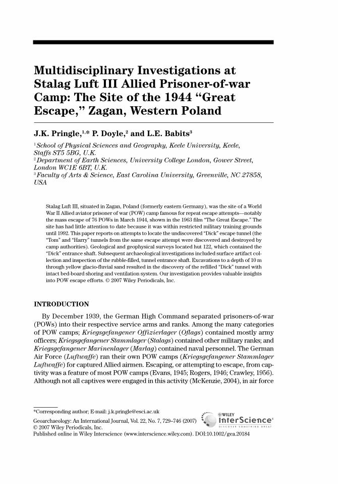
The official response to Allied escape attempts varied through the war, with policyin both army and air force camps leaning toward concentration of escapers in spe-cially constructed camps (Sonderlager) with greater security. Eventually, many recap-tured Allied airforce POWs ended up at Stalag Luft III, a camp located as far fromneutral and Allied forces countries as possible (Figure 1). Stalag Luft III was specif-ically designed to deter and detect potential escapers, and was constructed overtime as a series of separate compounds (Flockhart, 1945; Durand, 1988). The campwas situated within a typical East European dense, coniferous forest, close to the main Berlin-Breslau (now Wroclaw) rail route, providing access to the camp—aswell as a temptation for would-be escapers. As new compounds were required, addi-tional forest clearance took place. Significant phases of camp expansion occurredas increasing numbers of POWs arrived following the expansion of the Allied strate-gic bombing campaign of Germany. Such site expansion allowed prisoners to make covert measurements, inspect site plans, and prepare escape equipment(Crawley, 1956).
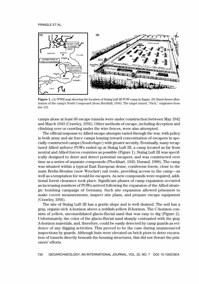
The site of Stalag Luft III has a gentle slope and is well drained. The soil has a gray, organic-rich A-horizon above a reddish-yellow B-horizon. The C-horizon con-sists of yellow, unconsolidated glacio-fluvial sand that was easy to dig (Figure 2).Unfortunately, the color of the glacio-fluvial sand sharply contrasted with the grayA-horizon materials, and, therefore, could be easily detected by camp guards as evi-dence of any digging activities. This proved to be the case during unannouncedinspections by guards. Although huts were elevated on brick piers to deter excava-tion of tunnels directly beneath the housing structures, this did not thwart the pris-oners’ efforts.
PRINGLE ET AL.
GEOARCHAEOLOGY: AN INTERNATIONAL JOURNAL, VOL. 22, NO. 7 DOI: 10.1002/GEA730
Figure 1. (A) WWII map showing the location of Stalag Luft III POW camp in Zagan. (B) Hand-drawn illus-tration of the camp’s North Compound (from Brickhill, 1950). The target tunnel, “Dick,” originates fromhut 122.
GEA227_623_20184.qxd 8/14/07 11:00 AM Page 730
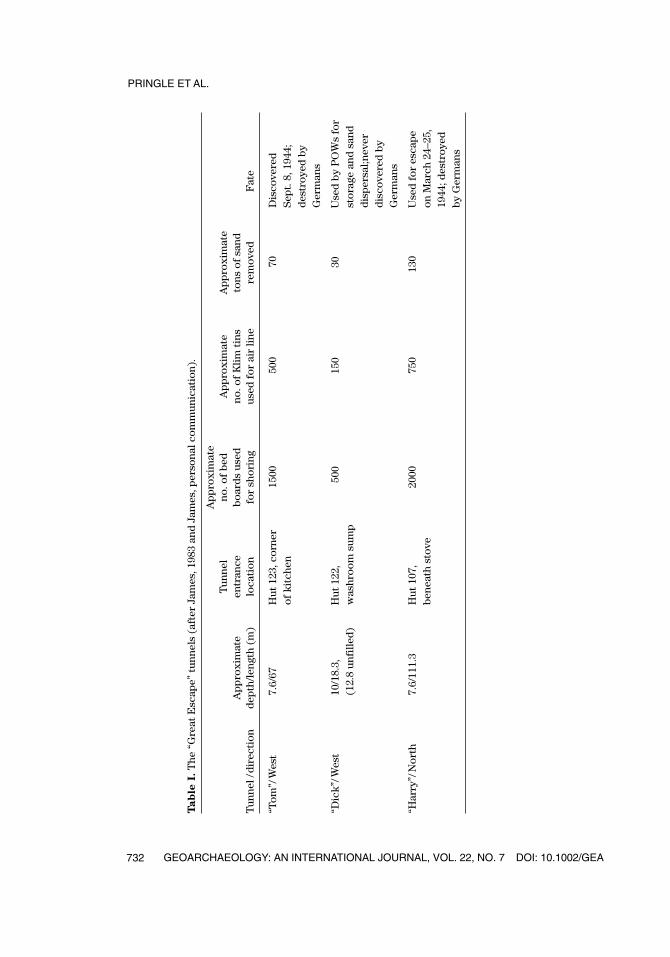
Initial escape attempts from Stalag Luft III (from the original East Compound)were made with varying degrees of success and involved deception as well as bothdeep and shallow tunnels (Flockhart, 1945; Williams, 1949; Crawley, 1956). An escapecommittee, which was common in most POW camps, coordinated these efforts.Following the construction of the North Compound, into which many escapers weremoved, a new escape committee, headed by “Big X” Squadron Leader Roger Bushell,was formed for this compound. The committee used previous experience to organ-ize the simultaneous digging of three escape tunnels code-named “Tom,” “Dick,” and“Harry” in 1943–44 (Table I). Of these tunnels, “Tom” was discovered and destroyedby the camp guards in 1943 (Brickhill, 1950; James, 1983). Following this discovery,work on “Dick” was discontinued, with “Harry” being used for the “Great Escape” onthe night of March 23–24, 1944, when 76 POWs actually exited the tunnel (see Brickhill,
DOI: 10.1002/GEA GEOARCHAEOLOGY: AN INTERNATIONAL JOURNAL, VOL. 22, NO. 7
MULTIDISCIPLINARY INVESTIGATIONS AT STALAG LUFT III
731
Figure 2. Photograph of undisturbed soil at the Stalag Luft III POW camp. Soil horizons are indicated anddescribed to the right of the photograph. Note the sandy glacio-fluvial deposits (C-horizon) with planarcross-bedding (see inset).
GEA227_623_20184.qxd 8/14/07 11:00 AM Page 731
PRINGLE ET AL.
GEOARCHAEOLOGY: AN INTERNATIONAL JOURNAL, VOL. 22, NO. 7 DOI: 10.1002/GEA732
Tab
le I
.T
he
“Gre
at E
scap
e” t
un
nel
s (a
fter
Jam
es, 1
983
and
Jam
es, p
erso
nal
co
mm
un
icat
ion
).
Ap
pro
xim
ate
Tu
nn
eln
o. o
f b
ed
Ap
pro
xim
ate
Ap
pro
xim
ate
Ap
pro
xim
ate
entr
ance
bo
ard
s u
sed
n
o. o
f K
lim
tin
s to
ns
of
san
d
Tu
nn
el /
dir
ecti
on
dep
th/l
engt
h (
m)
loca
tio
nfo
r sh
ori
ng
use
d f
or
air
lin
ere
mo
ved
Fat
e
“To
m”/
Wes
t7.
6/67
Hu
t 12
3, c
orn
er15
0050
070
Dis
cove
red
o
f k
itch
enS
ept.
8, 1
944;
d
estr
oye
d b
yG
erm
ans
“Dic
k”/
Wes
t10
/18.
3,
Hu
t 12
2,
500
150
30U
sed
by
PO
Ws
for
(12.
8 u
nfi
lled
)w
ash
roo
m s
um
pst
ora
ge a
nd
san
dd
isp
ersa
l;nev
erd
isco
vere
d b
yG
erm
ans
“Har
ry”/
No
rth
7.6/
111.
3H
ut
107,
20
0075
013
0U
sed
fo
r es
cap
e b
enea
th s
tove
on
Mar
ch 2
4–25
,19
44; d
estr
oye
d
by
Ger
man
s
GEA227_623_20184.qxd 8/14/07 11:00 AM Page 732
1950; Crawley, 1956; James, 1983; Durand, 1988). Following the escape, it is estimatedthat 5 million Germans were mobilized to recapture them. Of the 76 that escaped, 3eventually reached Allied territory, but the remainder were recaptured, and 50 ofthem were executed by the Gestapo.
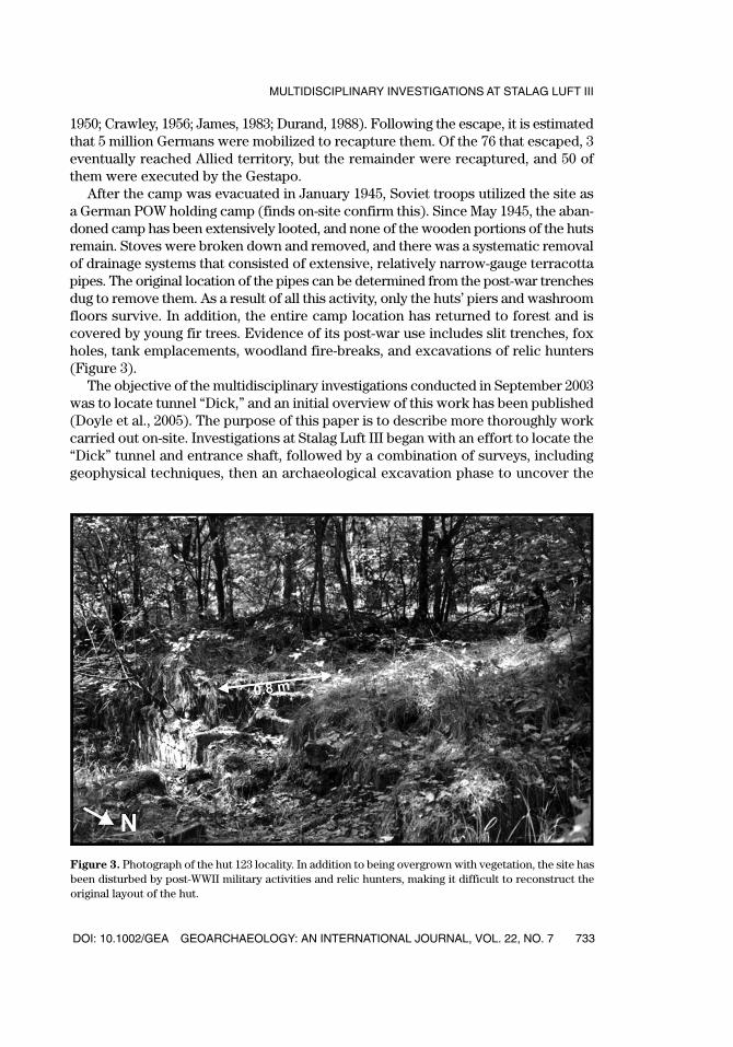
After the camp was evacuated in January 1945, Soviet troops utilized the site asa German POW holding camp (finds on-site confirm this). Since May 1945, the aban-doned camp has been extensively looted, and none of the wooden portions of the hutsremain. Stoves were broken down and removed, and there was a systematic removalof drainage systems that consisted of extensive, relatively narrow-gauge terracottapipes. The original location of the pipes can be determined from the post-war trenchesdug to remove them. As a result of all this activity, only the huts’ piers and washroomfloors survive. In addition, the entire camp location has returned to forest and iscovered by young fir trees. Evidence of its post-war use includes slit trenches, foxholes, tank emplacements, woodland fire-breaks, and excavations of relic hunters(Figure 3).
The objective of the multidisciplinary investigations conducted in September 2003was to locate tunnel “Dick,” and an initial overview of this work has been published(Doyle et al., 2005). The purpose of this paper is to describe more thoroughly workcarried out on-site. Investigations at Stalag Luft III began with an effort to locate the“Dick” tunnel and entrance shaft, followed by a combination of surveys, includinggeophysical techniques, then an archaeological excavation phase to uncover the
DOI: 10.1002/GEA GEOARCHAEOLOGY: AN INTERNATIONAL JOURNAL, VOL. 22, NO. 7
MULTIDISCIPLINARY INVESTIGATIONS AT STALAG LUFT III
733
Figure 3. Photograph of the hut 123 locality. In addition to being overgrown with vegetation, the site hasbeen disturbed by post-WWII military activities and relic hunters, making it difficult to reconstruct theoriginal layout of the hut.
GEA227_623_20184.qxd 8/14/07 11:00 AM Page 733

tunnel and any subsurface storage chambers and associated artifacts (Figure 4).Three surviving POWs from Stalag Luft III—Major General David “Tokyo” Jones(retired), a “digger”; Lieutenant Colonel Charles Huppert (retired), a “manufacturer”;and Squadron Leader B.A. “Jimmy” James (retired), an “escaper”—were present on-site for guidance.
INITIAL SITE INVESTIGATION
Site Surveys
An initial site survey was undertaken in May 2003 to try to determine the locationof hut 122, which, according to Brickhill (1950), contained the “Dick” tunnel entranceshaft. Because of reforestation and extensive looting of the site following World War II, the hut’s location was very difficult to determine. Linear trenches left duringthe post-war removal of drainage pipes were useful, however, as they could be tracedthrough the forest.
Hut locations on 1:10,000 site maps (Soviet and Polish) were found to be inaccu-rate; Allied 1944 aerial reconnaissance photographs were used instead to correlatepresent ground features with the camp structure (Figure 5A). Because of the densewoodland, it was not possible to undertake conventional theodolite surveying; meas-uring tapes and bearing information were used instead. The most important refer-ence point located during the survey was an isolated, brick-lined fire pool (filled withwater during occupation). This 20 m2 fire pool is visible in photographs taken during
PRINGLE ET AL.
GEOARCHAEOLOGY: AN INTERNATIONAL JOURNAL, VOL. 22, NO. 7 DOI: 10.1002/GEA734
Figure 4. Illustration of “Harry” tunnel (from Brickhill, 1950).
GEA227_623_20184.qxd 8/14/07 11:00 AM Page 734
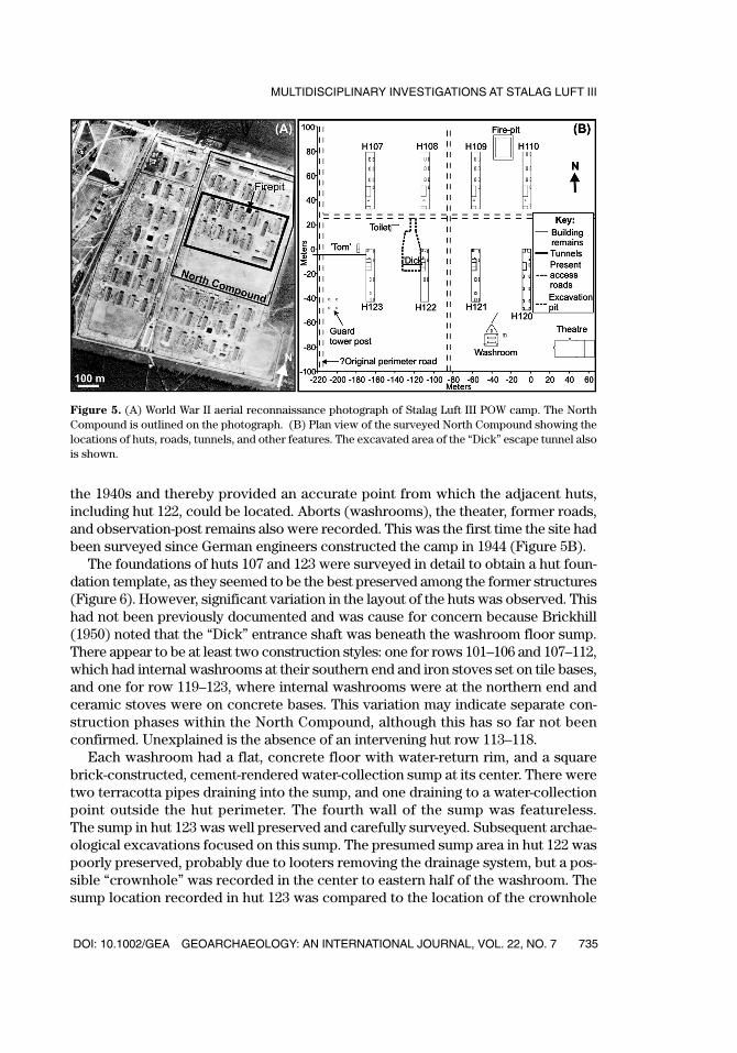
the 1940s and thereby provided an accurate point from which the adjacent huts,including hut 122, could be located. Aborts (washrooms), the theater, former roads,and observation-post remains also were recorded. This was the first time the site hadbeen surveyed since German engineers constructed the camp in 1944 (Figure 5B).
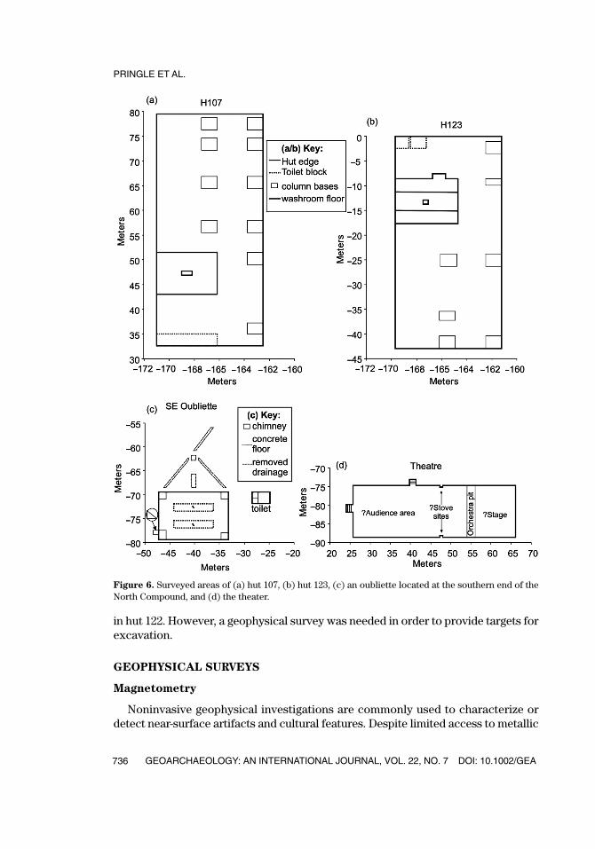
The foundations of huts 107 and 123 were surveyed in detail to obtain a hut foun-dation template, as they seemed to be the best preserved among the former structures(Figure 6). However, significant variation in the layout of the huts was observed. Thishad not been previously documented and was cause for concern because Brickhill(1950) noted that the “Dick” entrance shaft was beneath the washroom floor sump.There appear to be at least two construction styles: one for rows 101–106 and 107–112,which had internal washrooms at their southern end and iron stoves set on tile bases,and one for row 119–123, where internal washrooms were at the northern end andceramic stoves were on concrete bases. This variation may indicate separate con-struction phases within the North Compound, although this has so far not beenconfirmed. Unexplained is the absence of an intervening hut row 113–118.
Each washroom had a flat, concrete floor with water-return rim, and a squarebrick-constructed, cement-rendered water-collection sump at its center. There weretwo terracotta pipes draining into the sump, and one draining to a water-collectionpoint outside the hut perimeter. The fourth wall of the sump was featureless. The sump in hut 123 was well preserved and carefully surveyed. Subsequent archae-ological excavations focused on this sump. The presumed sump area in hut 122 waspoorly preserved, probably due to looters removing the drainage system, but a pos-sible “crownhole” was recorded in the center to eastern half of the washroom. Thesump location recorded in hut 123 was compared to the location of the crownhole
DOI: 10.1002/GEA GEOARCHAEOLOGY: AN INTERNATIONAL JOURNAL, VOL. 22, NO. 7
MULTIDISCIPLINARY INVESTIGATIONS AT STALAG LUFT III
735
Figure 5. (A) World War II aerial reconnaissance photograph of Stalag Luft III POW camp. The NorthCompound is outlined on the photograph. (B) Plan view of the surveyed North Compound showing thelocations of huts, roads, tunnels, and other features. The excavated area of the “Dick” escape tunnel alsois shown.
GEA227_623_20184.qxd 8/14/07 11:00 AM Page 735
in hut 122. However, a geophysical survey was needed in order to provide targets forexcavation.
GEOPHYSICAL SURVEYS
Magnetometry
Noninvasive geophysical investigations are commonly used to characterize ordetect near-surface artifacts and cultural features. Despite limited access to metallic
PRINGLE ET AL.
GEOARCHAEOLOGY: AN INTERNATIONAL JOURNAL, VOL. 22, NO. 7 DOI: 10.1002/GEA736
Figure 6. Surveyed areas of (a) hut 107, (b) hut 123, (c) an oubliette located at the southern end of theNorth Compound, and (d) the theater.
GEA227_623_20184.qxd 8/14/07 11:00 AM Page 736
objects by the POWs (Brickhill, 1950), it was hoped that there might be enough metalin the entrance shaft, storage chamber, or tunnel to be detected. The magnetic methodis probably the land-based geophysical tool most frequently used by archaeologists(e.g., Abbas et al., 2005; Abdallatif et al., 2005). In our study, proton precession mag-netometer equipment was employed to acquire magnetic anomaly data. This equip-ment can be used to rapidly measure the total Earth’s magnetic field at a specifiedsampling point. Variations in readings can be caused by different buried materials (e.g.,metallic objects, pipes, etc.), but careful calibration with a known reference point isneeded during sampling, as magnetic strength varies during the day (termed “drift”),with the strongest recordings occurring when the instrument is pointing north.
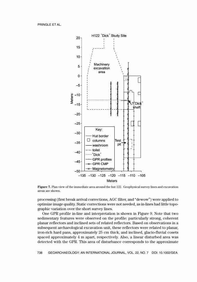
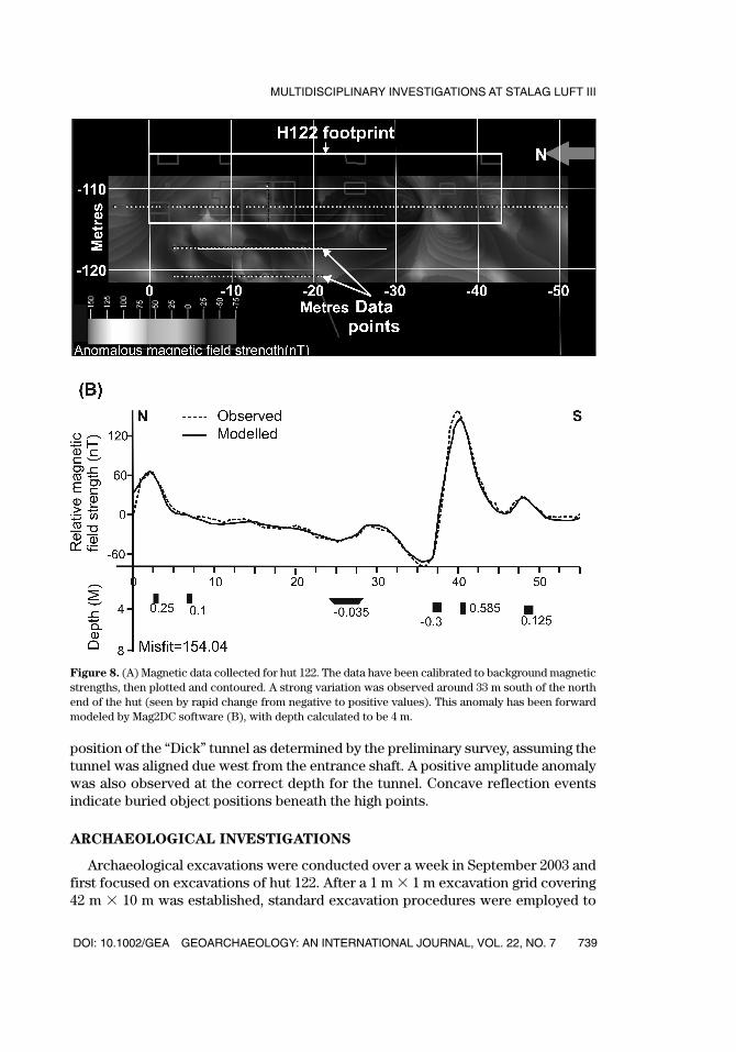
Magnetic data were collected along four lines orientated north–south, and one lineoriented east–west over the supposed tunnel entrance beneath the sump (Figure 7).Results were corrected for drift and plotted. Although there was disappointinglylittle variation in readings observed around the presumed tunnel entrance shaft, a sig-nificant bipolar anomaly was observed 33 m south of the northern end of hut 122(Figure 8A). Simple Mag2DC forward modeling of the magnetic anomaly showed amore than 0.5 m diameter metallic object at a depth of ca. 4 m (Figure 8B). This maybe modern unexploded ordnance and was not investigated further for obvious safetyreasons.
Ground-Penetrating Radar
Ground-penetrating radar (GPR) investigations of archaeological sites are nowcommonplace (e.g., Baker et al., 1997; Abbas et al., 2005), as near-surface electricaland magnetic property contrasts can be rapidly acquired and directly viewed duringacquisition of high-resolution, two-dimensional profiles across a study site. (SeeLeckebusch [2003] for a useful overview of the GPR theory and archaeological appli-cations.) It was hoped that angular supports used for tunnel shoring might still bein place, and therefore be imaged by the GPR survey. However, Brickhill (1950) notedthat “Dick was full now to the base of the shaft” with the sand removed from “Tom,”and the men were “also taking out the box frames and rails,” something confirmedin historic accounts (Flockhart, 1945). If this were true, then it would be difficult todifferentiate refilled tunnel sand from the undisturbed, sandy, glacio-fluvial depositssurrounding the tunnel. We were also concerned that significant subsurface distur-bance resulting from military activities and relic hunters would compromise theGPR survey. Furthermore, it could be difficult to distinguish the target tunnel fromother collapsed tunnels.
Following initial testing of the GPR PulseEkko™ 1000 equipment using both 50 and 100 MHz central frequency antennae, the 50 MHz central frequency antennaewere used to acquire two-dimensional, fixed-offset in-lines, orientated north-south,over the hut foundations, 3 m and 6.5 m west of hut 122 (Figure 6). The 0.25 m sepa-rated traces were acquired along each in-line with a 1000v transmitter, using a setupof 256 stacks and a 300 ns Time Window. A Common Midpoint (CMP) gather was alsoacquired; a subsequent velocity analysis of 0.15 m/ns was used to convert profilesfrom two-way time (nanoseconds) to depth (meters). Standard post-acquisition GPR
DOI: 10.1002/GEA GEOARCHAEOLOGY: AN INTERNATIONAL JOURNAL, VOL. 22, NO. 7
MULTIDISCIPLINARY INVESTIGATIONS AT STALAG LUFT III
737
GEA227_623_20184.qxd 8/14/07 11:00 AM Page 737
processing (first break arrival corrections, AGC filter, and “dewow”) were applied tooptimize image quality. Static corrections were not needed, as in-lines had little topo-graphic variation over the short survey lines.
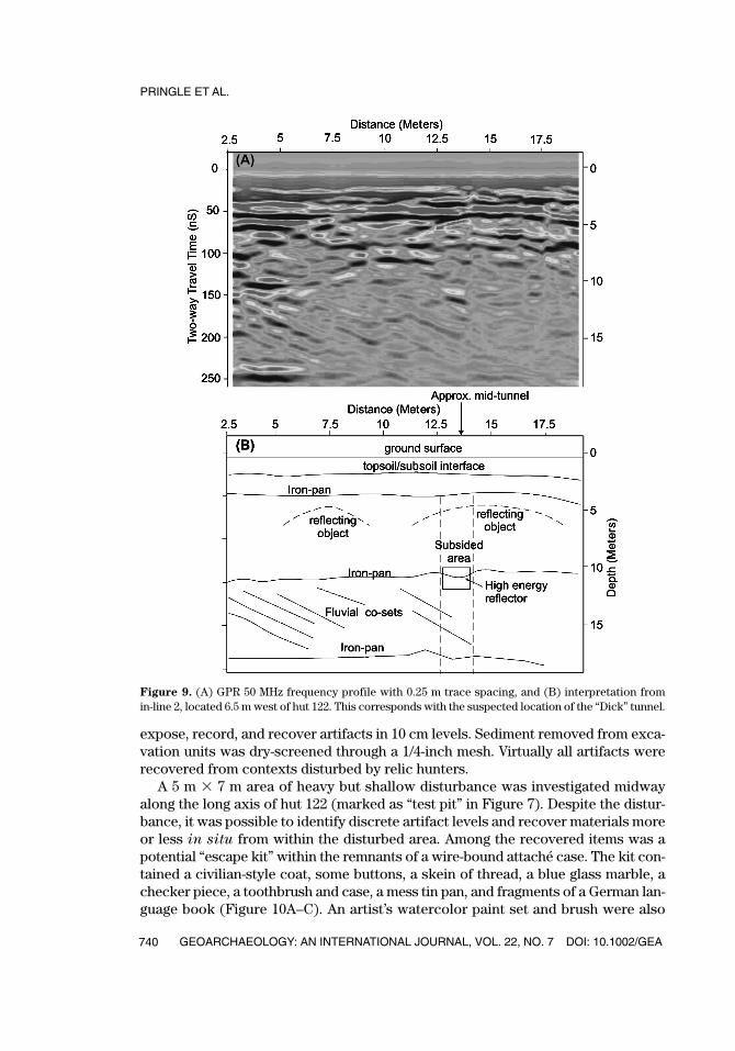
One GPR profile in-line and interpretation is shown in Figure 9. Note that twosedimentary features were observed on the profile: particularly strong, coherentplanar reflectors and inclined sets of related reflectors. Based on observations in asubsequent archaeological excavation unit, these reflectors were related to planar,iron-rich hard pans, approximately 25 cm thick, and inclined, glacio-fluvial cosetsspaced approximately 4 m apart, respectively. Also, a linear disturbed area wasdetected with the GPR. This area of disturbance corresponds to the approximate
PRINGLE ET AL.
GEOARCHAEOLOGY: AN INTERNATIONAL JOURNAL, VOL. 22, NO. 7 DOI: 10.1002/GEA738
Figure 7. Plan view of the immediate area around the hut 122. Geophysical survey lines and excavationareas are shown.
GEA227_623_20184.qxd 8/14/07 11:00 AM Page 738
DOI: 10.1002/GEA GEOARCHAEOLOGY: AN INTERNATIONAL JOURNAL, VOL. 22, NO. 7
MULTIDISCIPLINARY INVESTIGATIONS AT STALAG LUFT III
739
Figure 8. (A) Magnetic data collected for hut 122. The data have been calibrated to background magneticstrengths, then plotted and contoured. A strong variation was observed around 33 m south of the northend of the hut (seen by rapid change from negative to positive values). This anomaly has been forwardmodeled by Mag2DC software (B), with depth calculated to be 4 m.
position of the “Dick” tunnel as determined by the preliminary survey, assuming thetunnel was aligned due west from the entrance shaft. A positive amplitude anomalywas also observed at the correct depth for the tunnel. Concave reflection eventsindicate buried object positions beneath the high points.
ARCHAEOLOGICAL INVESTIGATIONS
Archaeological excavations were conducted over a week in September 2003 andfirst focused on excavations of hut 122. After a 1 m � 1 m excavation grid covering42 m � 10 m was established, standard excavation procedures were employed to
GEA227_623_20184.qxd 8/14/07 11:00 AM Page 739
expose, record, and recover artifacts in 10 cm levels. Sediment removed from exca-vation units was dry-screened through a 1/4-inch mesh. Virtually all artifacts wererecovered from contexts disturbed by relic hunters.
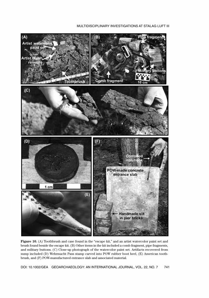
A 5 m � 7 m area of heavy but shallow disturbance was investigated midwayalong the long axis of hut 122 (marked as “test pit” in Figure 7). Despite the distur-bance, it was possible to identify discrete artifact levels and recover materials moreor less in situ from within the disturbed area. Among the recovered items was apotential “escape kit” within the remnants of a wire-bound attaché case. The kit con-tained a civilian-style coat, some buttons, a skein of thread, a blue glass marble, achecker piece, a toothbrush and case, a mess tin pan, and fragments of a German lan-guage book (Figure 10A–C). An artist’s watercolor paint set and brush were also
PRINGLE ET AL.
GEOARCHAEOLOGY: AN INTERNATIONAL JOURNAL, VOL. 22, NO. 7 DOI: 10.1002/GEA740
Figure 9. (A) GPR 50 MHz frequency profile with 0.25 m trace spacing, and (B) interpretation from in-line 2, located 6.5 m west of hut 122. This corresponds with the suspected location of the “Dick” tunnel.
GEA227_623_20184.qxd 8/14/07 11:00 AM Page 740
DOI: 10.1002/GEA GEOARCHAEOLOGY: AN INTERNATIONAL JOURNAL, VOL. 22, NO. 7
MULTIDISCIPLINARY INVESTIGATIONS AT STALAG LUFT III
741
Figure 10. (A) Toothbrush and case found in the “escape kit,” and an artist watercolor paint set andbrush found beside the escape kit. (B) Other items in the kit included a comb fragment, pipe fragments,and military buttons. (C) Close-up photograph of the watercolor paint set. Artifacts recovered fromsump included (D) Wehrmacht Pass stamp carved into POW rubber boot heel, (E) American tooth-brush, and (F) POW-manufactured entrance slab and associated material.
GEA227_623_20184.qxd 8/14/07 11:00 AM Page 741
recovered with this case. The case probably was lodged beneath the hut for laterretrieval. When the sump to hut 123 was investigated, it was found to contain arti-facts consistent with its use, including underwear buttons, small animal bones, ahairbrush, and a nailbrush (Figure 10D-F).
Archaeological investigations also focused on the presumed tunnel entrance shaft(marked in Figure 7) that was accessed via one side of the hut 122 washroom sump.Troweled hand excavation of the 1 m � 1 m area of disturbed soil, brick, concrete,and pipe debris was undertaken. A 47.5 cm � 65.5 cm � 4 cm thick concrete slab withtwo notches on one face was found within the sump fill. The slab’s edge above thenotches was slightly abraded (Figure 10F). A corroded, 26 cm long iron hook alsowas found, the hook end perfectly fitting the notches and edge of the concrete slab.This hook probably was used to pull up the slab door to allow shaft access. Betweenthe sump floor and a north-south-orientated concrete “sill” was a groove 4 cm wideand sill slits on two narrow red bricks. According to tunnel veteran General Jones,tunnel workers slipped over the sill when entering the shaft beside the sump. Grayclay (possibly mixed with issue soap) was also found within the sill and probably wasused to seal off the slab to prevent sump leakage into the shaft.
Excavations below the floor of the sump and the debris layer exposed an area ofmottled soil that is 56 � 64 cm in plan view. This mass of soil probably representsbackfill, but is too narrow for the complete shaft. Due to safety concerns over the10 m deep vertical shaft, further excavations were discontinued at this locality. Thefollowing artifacts were recovered during excavation of the entrance shaft and back-filled tunnel: a lamp made from a Red Cross parcel cheese tin (identified by SquadronLeader James and Lieutenant Colonel Huppert) and an associated candle that wasused for lighting when the camp electricity was cut during air raids; some electricalflex cable and a porcelain electrical light fitting with opal glass fragments; and arough-cut rubber disk from a boot heel, bearing a Wehrmacht eagle incised on oneside with its head pointing to the right—consistent with its use as a stamp, as the usualdirection is to the left (Figure 10D).
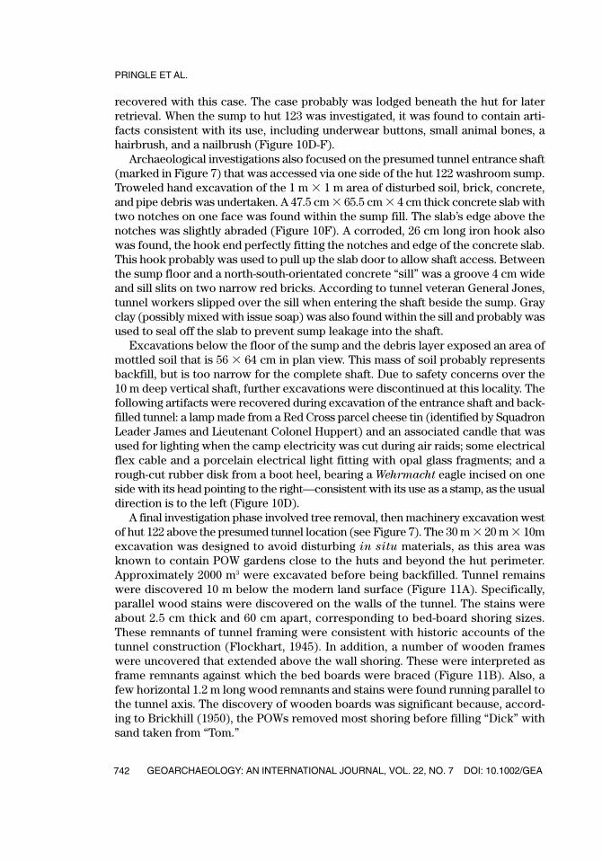
A final investigation phase involved tree removal, then machinery excavation westof hut 122 above the presumed tunnel location (see Figure 7). The 30 m � 20 m � 10mexcavation was designed to avoid disturbing in situ materials, as this area wasknown to contain POW gardens close to the huts and beyond the hut perimeter.Approximately 2000 m3 were excavated before being backfilled. Tunnel remainswere discovered 10 m below the modern land surface (Figure 11A). Specifically,parallel wood stains were discovered on the walls of the tunnel. The stains wereabout 2.5 cm thick and 60 cm apart, corresponding to bed-board shoring sizes.These remnants of tunnel framing were consistent with historic accounts of thetunnel construction (Flockhart, 1945). In addition, a number of wooden frameswere uncovered that extended above the wall shoring. These were interpreted asframe remnants against which the bed boards were braced (Figure 11B). Also, afew horizontal 1.2 m long wood remnants and stains were found running parallel tothe tunnel axis. The discovery of wooden boards was significant because, accord-ing to Brickhill (1950), the POWs removed most shoring before filling “Dick” withsand taken from “Tom.”
PRINGLE ET AL.
GEOARCHAEOLOGY: AN INTERNATIONAL JOURNAL, VOL. 22, NO. 7 DOI: 10.1002/GEA742
GEA227_623_20184.qxd 8/14/07 11:00 AM Page 742
DOI: 10.1002/GEA GEOARCHAEOLOGY: AN INTERNATIONAL JOURNAL, VOL. 22, NO. 7
MULTIDISCIPLINARY INVESTIGATIONS AT STALAG LUFT III
743
Figure 11. Photograph of (A) the bottom of “Dick” tunnel and the remains of the ventilation system; (B)an original and reproduced bed board; and (C) a reproduction of a bed-board frame used as shoring inthe tunnel.
GEA227_623_20184.qxd 8/14/07 11:00 AM Page 743
At a point 30 m west of the entrance shaft, four 10 cm diameter “Klim”1 tin canswere found joined together beneath a bed board in the tunnel center (Figure 11A).These Red Cross dried-milk cans formed a tunnel ventilation system, running thelength of the tunnel, from the diggers working at the sand face to a full-time workerpumping handmade bellows at the entrance shaft base to keep air circulating(Brickhill, 1950). Also, a small piece of cellophane that, according to Charles Huppert,may be from a cigarette packet (probably Chesterfield or Camel brand) was recov-ered from the tunnel floor. Crawley (1956) reported men smoked in halfway stationsduring tunneling.
Other artifacts recovered at Stalag Luft III were concentrated in isolated areas.These concentrations were located during the geophysical survey and are withinthe footprints of former huts. They may represent manufacturing and/or safe stor-age areas, but this is difficult to confirm.
SUMMARY AND CONCLUSIONS
Despite poor site preservation, dense vegetative cover, and considerable site dis-turbance, the multidisciplinary investigation of Stalag Luft III proved successful inlocating a variety of features in this World War II POW camp, including the entranceshaft and tunnel (“Dick”) used in the March 1944 “Great Escape.” Initially, 1944 aer-ial reconnaissance photographs were compared with observations on the ground inorder to locate camp structures, including hut 122, which harbored the entranceshaft to “Dick.” This photo-supported surface survey was followed by a noninvasivemagnetic and GPR survey of the camp. The geophysical survey had mixed success.Magnetometry was useful in detecting concentrations of ferrous-rich materials atshallow depths (� 5 m), but failed to locate the refilled “Dick” escape tunnel. Thisfailure is attributed to the paucity of ferrous-rich objects, the small magnetic sus-ceptibility difference between the undisturbed glacio-fluvial deposits and the sandused to refill the tunnel, and the great depth (10 m) of the target. However, the GPRdetected a linear disturbed area corresponding to the approximate position of the“Dick” tunnel, as determined by the initial surface survey.
Results of the geophysical survey allowed areas to be targeted for excavation,thereby increasing the efficiency of the archaeological investigation and reducing dis-turbance of in situ features and artifacts. The excavations revealed that the filled“Dick” tunnel was at a depth of 10 m. Remnants of a wire-bound attaché case con-taining a possible “escape kit” were found within the tunnel’s entrance shaft, andremains of wooden bed frames used for shoring were discovered in the former tun-nel. Also, part of the tunnel ventilation system, formed by connected metal Klimtins, was found intact. Former POWs assisted with the interpretation of the archae-ological record (Figure 12). Recovered artifacts were donated to the nearby Museumof Allied Prisoners of War and Martyrdom in Zagan.
PRINGLE ET AL.
GEOARCHAEOLOGY: AN INTERNATIONAL JOURNAL, VOL. 22, NO. 7 DOI: 10.1002/GEA744
1 Klim was the name given to powdered milk rations issued by the International Red Cross to allied pris-oners in Axis Forces Captivity during World War II. The name is a simple reversal of the word “milk.”
GEA227_623_20184.qxd 8/14/07 11:00 AM Page 744

The site of Stalag Luft III is currently undeveloped and offers considerable poten-tial for future investigations. It is estimated that over 100 tunnels were dug at this POWcamp during World War II. Although the detection of so many tunnels may seem for-midable, the methods used in our investigation for locating tunnel “Dick” provedcost-effective and relatively nondestructive. At least four other tunnels remain wor-thy of investigations: tunnel “Tom,” destroyed in 1943; tunnel “Harry,” the “GreatEscape” tunnel destroyed or partially filled in 1944, after the breakout; tunnel“George,” dug after the “Great Escape” as a potential mass escape tunnel in case ofreprisals; and, in the East Compound, the “Wooden Horse” tunnel, which led to thesuccessful escape of three prisoners in 1943 (Williams, 1949). Other POW camps inthe region, including at least eight camps for non-airforce personnel, also merit study.
Our study demonstrated the value of multidisciplinary investigations, including geo-physical surveys, at sites of conflict from World War II, and complements researchat other localities such as Point du Hoc in Normandy, the site of the U.S. Ranger’sattack in June 1944 (Everett et al., 2006). Surface survey and application of GPR andother geophysical techniques at Point du Hoc are increasing our understanding of theconstruction of World War II fixed fortifications (since destroyed), leading to betterunderstanding of how these fortifications were constructed and how they stood upto the assault in 1944. It is important to note that opportunities to reconstruct sites
DOI: 10.1002/GEA GEOARCHAEOLOGY: AN INTERNATIONAL JOURNAL, VOL. 22, NO. 7
MULTIDISCIPLINARY INVESTIGATIONS AT STALAG LUFT III
745
Figure 12. From left to right, Prof. Peter Doyle, Squadron Leader “Jimmy” James (RAF, retired), andColonel Charles Huppert (USAAF, retired) with recovered joined Klim tins that formed part of the “Dick”tunnel ventilation system.
GEA227_623_20184.qxd 8/14/07 11:00 AM Page 745
such as these are enhanced by the abundant archive materials available for 20th cen-tury conflicts, as well as geophysical survey methods such as those applied at StalagLuft III. Refined, these techniques may prove useful for investigating the extensivetunnels employed in World War I (e.g., Doyle et al., 2002).
Mark Radice, David Dugan, and Konrad Jankowski, producers of the documentary film that sponsoredthe excavation, are thanked for financial, logistical, and language support. Gabriel Moshenska and DanielPhillips are acknowledged for archaeological assistance. Stalag Luft III veterans Major General David“Tokyo” Jones (retired), Lieutenant Colonel Charles Huppert (retired), and Squadron Leader B.A. “Jimmy”James (retired) are thanked for contemporary knowledge and on-site advice. Nigel Cassidy at KeeleUniversity is acknowledged for GPR interpretation assistance. Chris Leech is thanked for GPR hardwareand software support, and Emma Preston is acknowledged for Schlumberger Petrel visualization softwaresupport. The authors wish to acknowledge Rolfe Mandel, Alston Thoms, and an anonymous reviewerwhose efforts greatly improved the manuscript.
REFERENCES
Abbas, A.M., Abdallatif, T.F., Shaaban, F.A., Salem, A., & Suh, M. (2005). Archaeological investigation ofthe eastern extensions of the Karnak Temple using ground-penetrating radar and magnetic tools.Geoarchaeology, 20, 537–554.
Abdallatif, T.F., Abd-All, E.M., Suh, M., Mohamad, R.M., & El-Hemaly, I.A. (2005). Magnetic tracing at AbuSir (Land of Forgotten Pyramids), northern Egypt. Geoarchaeology, 20, 483–503.
Baker, J.A., Anderson, N.L., & Pilles, P.J. (1997). Ground penetrating radar investigations in support ofarchaeological investigations. Computers & Geosciences, 23, 1093–1099.
Brickhill, P. (1950). The Great Escape (Vol. 1). London: Faber.Crawley, A. (1956). Escape from Germany—A history of R.A.F. escapes during the war (Vol. 1). London:
Collins.Doyle, P., Barton, P., Rosenbaum, M., Vandewalle, J., & Jacobs, K. (2002). Geoenvironmental implications
of military mining in Flanders, Belgium, 1914–1918. Environmental Geology, 43, 57–71.Doyle, P., Babits, L.E., & Pringle, J.K. (2005). “For you the war is over”: The archaeological record of
Stalag Luft III escape attempts. Fields of Conflict III Annual Meeting, Nashville, TN.Durand, A.A. (1988). Stalag Luft III. Baton Rouge, LA: Louisiana State University Press.Evans, A.J. (1945). Escape and liberation, 1940–1945 (Vol. 1). London: Hodder & Stoughton.Everett, M.E., Pierce, C.J., Save, N., Warden, R.R., Dickson, D.B., Burt, R.A. & Bradford, J.C. (2006)
Geophysical investigation of the June 6, 1944 D-Day invasion site at Pointe du Hoc, Normandy, France.Near Surface Geophysics, 4, 289–304.
Flockhart, C.B. (1945). A typescript history of Stalag Luft III (Sagan), Air Force personnel reports, April1942–January 1945. London: RAF Museum Archives, London RAF Museum.
James, B.A. (1983). Moonless night (Vol. 1). London: William Kimber.Leckebusch, J. (2003). Ground-penetrating radar: A modern three-dimensional prospection method.
Archaeological Prospection, 10, 213–240.McKenzie, S.P. (2004). The Colditz myth. Cambridge, MA: Harvard University Press.Rogers, D.J. (1946). An escape tunnel in Germany. The Mining Magazine, 75, 87–97.Williams, E. (1949). The wooden horse. London: Collins.
Received August 22, 2005Accepted for publication May 25, 2007
PRINGLE ET AL.
GEOARCHAEOLOGY: AN INTERNATIONAL JOURNAL, VOL. 22, NO. 7 DOI: 10.1002/GEA746
GEA227_623_20184.qxd 8/14/07 11:00 AM Page 746