Muhamad Sadly Center of Technology for Natural Resources ... · Muhamad Sadly Center of Technology...
31
@ M. Sadly, PTISDA BPPT 2011, All Right Reserved Sentinel Asia STEP-2 Joint Project Team Meeting (JPTM 2011) Malaysia, 11-14 July, 2011 Muhamad Sadly Center of Technology for Natural Resources Inventory (PTISDA) Agency for the Assessment and Application of Technology (BPPT) Indonesia
Transcript of Muhamad Sadly Center of Technology for Natural Resources ... · Muhamad Sadly Center of Technology...

@ M. Sadly, PTISDA BPPT 2011, All Right Reserved
Sentinel Asia STEP-2 Joint Project Team Meeting (JPTM 2011)Malaysia, 11-14 July, 2011
Muhamad SadlyCenter of Technology for Natural Resources
Inventory (PTISDA)Agency for the Assessment and Application of
Technology (BPPT)Indonesia

Today’s Topics

• Established on August 21, 1978.• An Indonesia Government agency that performactivities in the Assessment & Application of various technologies.
• Directly reporting to the President the Rep. of Indonesia
• Under coordination of the Ministry of Researchand Technology (RISTEK)


• Intermediation between technology providers & users
• Technology assessment
• Technology provider
• Technology clearing house
• Technology audit
• Productive utilization of BPPT’s products
• Developing technologies in a resource-sharing basis
• Dedicated and professional employees to serve stakeholders
• Internationally reputable
• Food Technology
• Health and Medicine Technology
• Energy Technology
• Information and Telecommunication Technology
• Transportation Technology
• Defense Technology
• Hazard Mitigation Technology
• Material Technology
• Manufacture Technology
• Earth & Environment Technology
• Technology Policy

Scope of Services: Hydrography – Oceanography, Geology –Geophysics Environment Monitoring, Fishery Exploration HARIMAU Project: JST JICA SATREPS
BPPT-JAMSTEC Japan, etc.

• An alternative solution for inter-island transportation problems
– >80 knots cruise speed; -Efficient fuel consumption
– Comfortable; -No port infrastructure required
• Design, aerodynamics/hydrodynamics model tests, remote-controlled flying model tests, detail design and prototypes manufacturing
• L × W × D = 4,400 × 800 × 750 mm
• Weight 300 kg• Max Depth 100 m• Cruising speed 4 knots• Observation instrument: Side
scan sonar• Communication: Underwater
acoustic modem
• L × W × H = 1,200 × 800 × 800 mm
• Weight 170 kg• Max Depth 300 m• Cruising speed 4 knots• Observation instrument:
camera, lights, robotic arm
• Communication & control: umbilical cable

• To increase water reserve for hydropower generation, irrigation, and water supply
• Fire suppression• Flood hazard mitigation
Copyright@ Sadly et al., BPPT, 25 March 2009

Since the short time in joining the program, therefore the activity reports related to the utilization of Sentinel Asia not much reported.
However, this document will explain the experience of PTISDA-BPPT in utilizing the Japan Aerospace Exploration Agency (JAXA)’s satellite data in monitoring natural disaster, especially related to volcanic eruption in Indonesia, Oil spill detection, etc.
Experiences in SAR data utilization SAR data application InSAR technique application DInSAR technique application

Sinabung Volcano: August – September 2010
• Sinabung Volcano is located on Sumatra Island, North Sumatra Province with 2460 m height. This volcano is a Pleistocene-to-Holocene stratovolcano of andesite and dacite in the Karo plateau of Karo Regency, North Sumatra. The first confirmed Holocene eruption at Sinabung, beginning on 27 August 2010.
• To understand this disaster, some PALSAR data are obtained from JAXA through Indonesia Working Group-3. The data are processed by PTISDA-BPPT and reported to Center of Volcanology and Geological Hazard Mitigation (CVGHM).
Interferogram of PALSAR data that covers Sinabung Volcano (July 16th 2010 – August 31st 2011)
Phase difference of PALSAR data that covers SinabungVolcano (July 16th 2010 – August 31st 2011)
Ref.:Agustan, et al., BPPT, 2009

Merapi Volcano: September - November 2010
• Merapi Volcano is located on the central part of Java Island with 2968 m height. Merapi, one of Indonesia's most active volcanoes, lies in one of the world's most densely populated areas and dominates the landscape immediately north of the major city of Yogyakarta. Merapi is the youngest and southernmost of a volcanic chain extending North-North-West to Ungaran volcano. The eruption started on October 26th – November 22nd 2010.
• To understand this disaster, some PALSAR data are obtained from JAXA through Indonesia Working Group-3. The data are processed by PTISDA-BPPT and reported to Center of Volcanology and Geological Hazard Mitigation (CVGHM).
Ref.:Agustan, et al., BPPT, 2009

Merapi Volcano: September - November 2010
Agustan, et al., BPPT, 2009

Bromo Volcano: November 26th – January 2011
• Bromo Volcano is a stratovolcano and located on the eastern part of Java Island with 2329 m height. This volcano is the youngest volcano in Tengger volcanic complex and one of Java's most active and most frequently visited volcanoes. The eruption started on November 26th – January 2011.
•To understand this disaster, some PALSAR data are obtained from JAXA through Indonesia Working Group-3. However, the process has not yet been completed.

Mud Volcano: Porong - Sidoarjo
East Java
Ref.:Agustan, et al., BPPT, 2009

=
θcosLOSVdisp

Vertical Displacements

Affected region• Direct deformed and
affected areas:– 8.7 km2 (15 months)– 11 km2 (18 months)– 13 km2 (21 months)– 17 km2 (24 months)– 20 km2 (26 months)– 25 km2 (32 months)

• Oil spill in Timor Sea caused by leaked of Well Head Platform in Montara oil field, Kimberley shore,West Australia.
• The evidence started at August 22, 2009.
• Spill volume approximately 20.000 ton (sorce: Jernelov, 2010)
SAR data application:Oil Spill Monitoring,
Montara 2009

Results
2/09/2009
14/09/2009
1/10/ 2009

2 Sept 2009
14 Sept 2009
1 Okt 2009

• Since February 2011, the Center of Technology for Natural Resources Inventory (PTISDA – BPPT) was accepted to one of Data Analysis Node (DAN) of Sentinel Asia.
• The tasks were to analyze the satellite data provided by Data Provider Node (DPN), to make value added product and discloses the result through the
Sentinel Asia System within the domestic legislation of h

Related to natural disaster, Indonesia has some national organizations with specific responsibilities. In coordinating for national level, BNPB or Badan Nasional Penanggulangan Bencana (National Agency for Disaster Management).
PTISDA (Center of Technology for Natural Resources Inventory) is belong to BPPT (Agency for the Assessment and Application of Technology has an important role to support BNPB in term of natural disaster monitoring based on satellite data or remote sensing method.
Especially for satellite image processing, PTISDA has a long and good reputation since 1987. Various satellite images i.e. Landsat, SPOT, ASTER, Quickbird, Worldview, Radarsat, ALOS-PALSAR, MODIS, etc. are able to be processed, analyzed and interpreted.
Some of data, products and services are represented in our national node called Nusantara Earth Observation Network or NEONet (http://neonet.bppt.go.id/).
NEONet has facilities and capabilities as web server, application server, database server, data storage and backup (16 TB), parallel computation system (cluster 16 CPUs), seismic data processing, multipurpose terrestrial survey, vehicle mobile dedicated fiber optic line, A0 scanner and plotter.
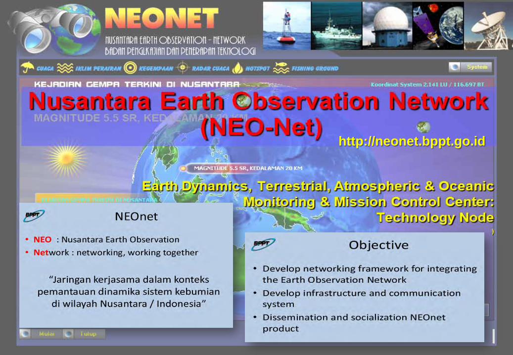
http://neonet.bppt.go.id

http://neonet.bppt.go.id

http://neonet.bppt.go.id

SMS Server
Web &Map Server
ConfirmationFrom Field by SMS
Users:- Government Agencies- Local Gov’s- Stakeholders
WebGIS
Weather RADAR
2
1
3
Flow Scenario 11. Rain is detected by Radar2. Confirmation to the field3. Display to WebGIS
1 2
Flow Scenario 21. Information from field to
server2. Display to WebGIS

AHA CENTRE • Owned by ASEAN ; Provides services to 10 Member States of ASEAN
• The management of AHA Centre reports to ASEAN; Has its own rules and regulations complying with ASEAN’s rules and regulation ; Contributions will come from Members States; Donors supports and contributions are welcome
• Work closely with National Disaster Management Organizations (NDMO) of 10 Member States
• Work closely with International Organizations; Managed by professionals from ASEAN Member States
AHA CENTRE

AHA Centre Office:BPPT Building I, 17th Floor, Jl. M. H. Thamrin No. 8, Jakarta, Indonesia
•Disaster information sharing and communication network
•Risk assessments, analysis and evaluation
•Hazard mapping, warning, analysis and evaluation
•Automatic reporting and dissemination system
•Automatic retrieval system for internal database and external resources
•GIS database; - Online mapping systems for visualization
•Standby arrangement database; - Knowledge management
database •Dynamic/ real-time Websites ; and others

Ref.: BPPT, M. Sadly, et. Al., 2011
Note:BNPB: National Agency for Disaster Management

Regional server for Indonesia (http://49.156.57.62/) basedon “the May 2011 News from Sentinel Asia Project Office” is difficult to access, the connection always refused.
The socialization of the utilization of Sentinel Asia’s data should be conducted, until now the detail instructions how to obtain satellite data not yet provided.
Ideas on how BPPT can better contribute to Sentinel Asia and regional disaster management community are welcome.

Thank you......Terima kasih....Arigato.......Danke....