Mt Arthur Coal Open Cut Modification Responses to …
80
Mt Arthur Coal Open Cut Modification Responses to Submissions
Transcript of Mt Arthur Coal Open Cut Modification Responses to …

Mt Arthur Coal Open Cut ModificationResponses to Submissions

Mt Arthur Coal Open Cut Modification – Response to Submissions on the Environmental Assessment
i
MT ARTHUR COAL OPEN CUT MODIFICATION ENVIRONMENTAL ASSESSMENT RESPONSES TO SUBMISSIONS SEPTEMBER 2013 TABLE OF CONTENTS Section Page
1 INTRODUCTION 1
2 PART A - RESPONSES TO PUBLIC SUBMISSIONS 2
3 PART B - RESPONSES TO GOVERNMENT SUBMISSIONS 38 3.1 NSW HEALTH 38 3.2 DAMS SAFETY COMMITTEE 41 3.3 DEPARTMENT OF TRADE, INVESTMENT, REGIONAL INFRASTRUCTURE
AND SERVICES – DIVISION OF RESOURCES AND ENERGY 42 3.4 OFFICE OF ENVIRONMENT AND HERITAGE 42 3.5 DEPARTMENT OF PRIMARY INDUSTRIES 48 3.6 MUSWELLBROOK SHIRE COUNCIL 54 3.7 RURAL FIRE SERVICE 68 3.8 ENVIRONMENT PROTECTION AUTHORITY 68 3.9 ROADS AND MARITIME SERVICES 74 3.10 DPI FISHERIES 74 3.11 OFFICE OF WATER 74 3.12 TRANSPORT FOR NSW 75
4 REFERENCES 76
LIST OF TABLES
Table 1 Reconciliation of Public Submissions
Table 2 Reconciliation of Special Interest Group Submissions
Table 3 Responses to Public Submissions

Mt Arthur Coal Open Cut Modification – Response to Submissions on the Environmental Assessment
1
1 INTRODUCTION Hunter Valley Energy Coal (HVEC), a wholly owned subsidiary of BHP Billiton Limited (BHP Billiton), prepared the Mt Arthur Coal Open Cut Modification Environmental Assessment (EA) to modify the Consolidation Project Approval (09_0062) under section 75W of Part 3A of the New South Wales (NSW) Environmental Planning and Assessment Act 1979. The EA was placed on public exhibition by the NSW Department of Planning and Infrastructure (DP&I) from 24 April 2013 to 24 May 2013. During this period, government agencies, members of the public and other special interest groups were invited to provide submissions on the EA to the DP&I. HVEC’s responses to submissions have been structured as follows: • Part A – Responses to public and special interest group submissions.
• Part B – Responses to government submissions.

Mt Arthur Coal Open Cut Modification – Response to Submissions on the Environmental Assessment
2
2 PART A - RESPONSES TO PUBLIC SUBMISSIONS Table 1 provides a reconciliation of the submissions received from members of the public. Table 2 provides a reconciliation of the submissions received from special interest groups. The comments and issues raised are addressed in Table 3.
Table 1 Reconciliation of Public Submissions
Submission ID No. Name Nature of
Submission Issue ID No.
1 Henry and June, Peter and Julie Brown Objection 1 – 8
2 Mark Peel Objection 3, 4, 6, 9, 10
3 Elva and Warren Rankin Objection 11 – 13
4 Marg McLean Objection 4, 14 – 20
5 Craig Benjamin Objection 4, 55
6 Wendy White Objection 1, 4, 22, 23, 24, 27, 32, 42, 61
7 Craig Anderson (Amarina Farm) Objection 29, 38, 42, 43
8 Kaye Monro Objection 19, 22, 27, 29, 48, 49, 54, 62, 63
9 John George Kaye Objection 4, 16
10 Darley Australia Comment 4, 14, 22, 23, 24, 26, 31, 40, 41, 42, 44, 53, 66, 67, 68, 69
11 Amanda and Stuart Thomas (Redman Park)
Objection 4, 16, 22, 26, 31, 32, 38
12 Brett Keeping (Two Rivers) Objection 4, 14, 16, 22, 31, 52, 53
13 Meryan McRobert Objection 15, 23, 43, 3
14 Steve Phillips Objection 4, 15, 16, 19, 22 – 25, 45, 26 – 30, 31 – 38, 63
15 John Quayle (Winbirra Estate) Objection 15, 22, 31, 38
16 Allen Barry Objection 4, 15, 43, 55
17 Cruickshank Wines Pty Ltd (Cruickshank)
Objection 16, 22, 31, 42, 46, 52, 53
18 Jennifer Squillari Objection 4, 14, 22, 31, 52
19 Kylie Magner (Evolve Advertising and Marketing)
Objection 4, 14, 16, 43, 53
20 Melanie Sunderland (Hunter Equine) Objection 4, 22, 31, 53
Table 2
Reconciliation of Special Interest Group Submissions
Submission ID No. Name Nature of
Submission Issue ID No.
1 Construction, Forestry Mining and Energy Union
Support Support
2 Hunter Environment Lobby Inc Objection 27, 29, 47, 48, 49, 50, 51
3 Hunter Communities Network Objection 4, 8, 16, 23, 27, 30, 31, 47, 50, 53, 54
4 Scone Equine Hospital Oppose 4, 16, 19, 21, 22, 23, 25, 26, 27, 31, 32, 38, 43, 44, 52, 56
5 Wanaruah Local Aboriginal Land Council Comment 57, 58, 59, 60
6 Hunter Thoroughbred Breeders Association
Comment 4, 8, 16, 21– 46
7 Nature Conservation Council Objection 4, 16, 22, 23, 26, 27, 30, 31, 38, 47, 48, 63, 64, 65

Mt A
rthu
r C
oal O
pen
Cut
Mod
ifica
tion
– R
espo
nse
to S
ubm
issi
ons
on th
e E
nviro
nmen
tal A
sses
smen
t
3
Tab
le 3
R
esp
on
ses
to P
ub
lic S
ub
mis
sio
ns
Issu
e ID
N
o.
Su
bje
ct
Issu
es R
aise
d
Res
po
nse
1 N
oise
C
once
rn w
as r
aise
d in
re
latio
n to
pot
entia
l noi
se
impa
cts,
incl
udin
g au
dibl
e no
ise
and
infr
asou
nd (
low
fr
eque
ncy)
dis
turb
ance
s.
Noi
se im
pact
s as
soci
ated
with
the
Mod
ifica
tion
wer
e co
mpa
red
to th
e C
onso
lidat
ion
Pro
ject
EA
and
pro
ject
-spe
cific
noi
se c
riter
ia.
Cha
nges
in n
oise
pre
dict
ed e
xcee
danc
es r
elat
ive
to th
e C
onso
lidat
ion
Pro
ject
EA
are
det
aile
d be
low
:
• on
e ne
w n
oise
mar
gina
l man
agem
ent z
one
exce
edan
ce (
less
than
5 A
-wei
ghte
d de
cibe
ls [d
BA
] abo
ve th
e cr
iteria
);
• tw
o ex
istin
g no
ise
man
agem
ent z
one
exce
edan
ces
have
mov
ed in
to th
e no
ise
acqu
isiti
on z
one
(gre
ater
than
5 d
BA
abo
ve th
e cr
iteria
), th
ese
two
prop
ertie
s ar
e al
read
y in
the
zone
of a
cqui
sitio
n fo
r ai
r qu
ality
und
er th
e cu
rren
t Pro
ject
App
rova
l 09_
0062
; and
• on
e ex
istin
g no
ise
affe
ctat
ion
exce
edan
ce m
oves
into
the
nois
e m
anag
emen
t zon
e.
Min
ing
activ
ities
will
con
tinue
to
be u
nder
take
n in
acc
orda
nce
with
the
app
rove
d M
t A
rthu
r C
oal N
oise
Man
agem
ent
Pla
n w
hich
det
ails
th
e m
itiga
tion
and
man
agem
ent m
easu
res
alre
ady
in p
lace
. The
hie
rarc
hy o
f con
trol
s ar
e as
follo
ws:
• C
ontr
ollin
g no
ise
at th
e so
urce
(su
ch a
s eq
uipm
ent n
oise
atte
nuat
ion)
.
• C
ontr
ollin
g th
e tr
ansm
issi
on o
f noi
se (
the
use
of b
arrie
rs a
nd la
nd-u
se c
ontr
ols)
.
• C
ontr
ollin
g no
ise
at th
e re
ceiv
er (
such
as
the
inst
alla
tion
of d
oubl
e gl
azin
g w
indo
ws,
air
cond
ition
or
insu
latio
n).
The
Noi
se a
nd B
last
ing
Ass
essm
ent
(App
endi
x G
of
the
EA
) ha
s be
en u
nder
take
n in
acc
orda
nce
with
the
Dire
ctor
-Gen
eral
’s
Req
uire
men
ts (
DR
Gs)
and
var
ious
gui
delin
es, w
hich
incl
ude:
• In
dust
rial N
oise
Pol
icy
(IN
P)
(NS
W E
nviro
nmen
t Pro
tect
ion
Aut
horit
y [E
PA
], 20
00);
• T
echn
ical
Bas
is fo
r G
uide
lines
to M
inim
ise
Ann
oyan
ce d
ue to
Bla
stin
g O
verp
ress
ure
and
Gro
und
Vib
ratio
n (A
ustr
alia
n an
d N
ew
Zea
land
Env
ironm
ent a
nd C
ounc
il, 1
990)
;
• E
nviro
nmen
tal A
sses
smen
t Req
uire
men
ts fo
r R
ail T
raffi
c G
ener
atin
g D
evel
opm
ents
(E
PA
, 201
2); a
nd
• In
terim
Con
stru
ctio
n N
oise
Gui
delin
e (D
epar
tmen
t of E
nviro
nmen
t and
Clim
ate
Cha
nge,
200
9).
The
INP
sta
tes
the
follo
win
g in
rel
atio
n to
low
freq
uenc
y no
ise
(em
phas
is a
dded
):
Whe
re a
noi
se s
ourc
e co
ntai
ns c
erta
in c
hara
cter
istic
s, s
uch
as to
nalit
y, im
puls
iven
ess,
inte
rmitt
ency
, irr
egul
arity
or
dom
inan
t low
-fr
eque
ncy
cont
ent,
ther
e is
evi
denc
e to
sug
gest
that
it c
an c
ause
gre
ater
ann
oyan
ce th
an o
ther
noi
se a
t the
sam
e no
ise
leve
l.
The
201
2 A
nnua
l Env
ironm
enta
l Man
agem
ent R
epor
t (A
EM
R)
(BH
P B
illito
n, 2
012a
) st
ates
the
follo
win
g w
ith r
espe
ct to
low
freq
uenc
y no
ise
com
plai
nts:
Dur
ing
the
repo
rtin
g pe
riod
[1 J
anua
ry 2
012
to 3
0 Ju
ne 2
012]
, Mt A
rthu
r C
oal r
ecei
ved
28 c
ompl
aint
s re
late
d to
noi
se. O
f the
se 2
6 w
ere
from
a s
ingl
e re
side
nt o
n R
oxbu
rgh
Roa
d co
ncer
ned
abou
t low
freq
uenc
y m
inin
g no
ise.
Dis
cuss
ions
wer
e he
ld w
ith
neig
hbou
ring
min
es a
nd in
vest
igat
ions
con
duct
ed in
an
atte
mpt
to d
eter
min
e an
d ad
dres
s th
e so
urce
of t
his
nois
e. R
eal-t
ime
mon
itorin
g at
the
time
of e
ach
com
plai
nt s
how
ed th
at n
oise
leve
ls fr
om M
t Art
hur
Coa
l wer
e w
ithin
sta
tuto
ry li
mits
.
Mt A
rthu
r C
oal O
pen
Cut
Mod
ifica
tion
– R
espo
nse
to S
ubm
issi
ons
on th
e E
nviro
nmen
tal A
sses
smen
t
4
Issu
e ID
N
o.
Su
bje
ct
Issu
es R
aise
d
Res
po
nse
1 (C
ont.)
N
oise
A lo
w f
requ
ency
noi
se in
vest
igat
ion
was
und
erta
ken
at a
rec
eive
r lo
cate
d no
rth-
wes
t of
Mt
Art
hur
Coa
l min
e w
as u
nder
take
n by
SLR
C
onsu
lting
Aus
tral
ia P
ty L
td (
2013
) fo
llow
ing
com
plai
nts
of lo
w f
requ
ency
noi
se fr
om a
nea
rby
min
e. T
he r
epor
t di
d no
t id
entif
y an
y lo
w
freq
uenc
y no
ise
issu
es fr
om th
e M
t Art
hur
Coa
l min
e, r
elev
antly
con
clud
ing:
Mt A
rthu
r C
HP
P is
not
a s
igni
fican
t con
trib
utor
to a
mbi
ent n
oise
leve
ls in
the
16 H
z an
d 25
Hz
1/3
octa
ve b
ands
at t
he m
onito
ring
loca
tions
.
No
low
fre
quen
cy n
oise
iss
ues
are
expe
cted
for
the
Mod
ifica
tion
give
n th
e si
mila
rity
of t
he e
xist
ing
oper
atio
ns t
o th
e pr
opos
ed
oper
atio
ns. I
n ad
ditio
n, th
ere
are
no r
elev
ant c
riter
ia fo
r lo
w fr
eque
ncy
nois
e pr
ovid
ed b
y th
e E
PA
to a
sses
s su
ch n
oise
impa
cts.
Con
sequ
ently
, th
e as
sess
men
t pr
ovid
ed in
the
EA
bas
ed o
n ‘A
’ wei
ghtin
g no
ise
leve
ls is
con
side
red
to b
e in
acc
orda
nce
with
the
IN
P
and
ther
efor
e ap
prop
riate
.
2 B
last
ing
Con
cern
was
rai
sed
in
rela
tion
to v
ibra
tion
effe
cts
and
pote
ntia
l bui
ldin
g da
mag
e.
With
res
pect
to p
oten
tial v
ibra
tion
and
airb
last
impa
cts
at th
e M
odifi
catio
n po
tent
ial i
mpa
cts
wou
ld b
e lim
ited
due
to th
e im
plem
enta
tion
of B
last
Con
trol
Are
as, a
s de
scrib
ed in
Sec
tion
10.4
of A
ppen
dix
G o
f the
EA
.
Tw
o B
last
Con
trol
Are
as w
ere
defin
ed in
the
Con
solid
atio
n P
roje
ct N
oise
and
Bla
stin
g A
sses
smen
t whe
re H
VE
C is
req
uire
d to
m
anag
e bl
asts
(F
igur
e 10
-1).
For
the
Mod
ifica
tion
an a
sses
smen
t of b
last
ing
in th
e ad
ditio
nal o
pen
cut p
it ar
eas
has
been
un
dert
aken
. T
he p
redi
ctio
ns o
f bla
st o
verp
ress
ure
and
vibr
atio
n in
dica
te th
at th
e w
este
rn B
last
Con
trol
Are
a m
ust b
e ex
tend
ed to
sa
tisfy
the
rele
vant
crit
eria
as
show
n on
Fig
ure
10-1
.
To
impr
ove
blas
t vib
ratio
n m
anag
emen
t at t
he M
t Art
hur
Coa
l min
e, H
VE
C in
trod
uced
ele
ctro
nic
deto
nato
rs (
for
use
acro
ss th
e en
tire
site
) in
Aug
ust 2
010.
Ele
ctro
nic
deto
nato
rs im
prov
e bl
ast i
nitia
tion
sequ
ence
by
accu
rate
ly c
ontr
ollin
g tim
ing
dela
ys o
f bla
sts,
incr
ease
ro
ck fr
agm
enta
tion,
low
er v
ibra
tion
leve
ls a
nd d
ecre
ase
the
pote
ntia
l of f
lyro
ck.
The
initi
al e
lect
roni
c sh
ot r
educ
ed th
e vi
brat
ion
at th
e E
ding
lass
ie H
omes
tead
by
50 p
erce
nt o
n st
anda
rd in
itiat
ing
expl
osiv
es.
Con
tinue
d re
finem
ent o
f the
ele
ctro
nic
tech
niqu
es in
this
are
a re
sulte
d in
five
bla
sts
whe
re v
ibra
tion
at th
e E
ding
lass
ie H
omes
tead
was
m
anag
ed w
ithou
t the
nee
d to
red
uce
the
size
of t
he a
rea
blas
ted
(sho
t siz
e).
The
re h
ave
been
no
repo
rtab
le e
xcee
danc
es o
f the
10
mm
/s b
uild
ing
vibr
atio
n da
mag
e cr
iterio
n si
nce
2007
. With
the
cont
inue
d im
plem
enta
tion
of th
ese
mea
sure
s, n
o bu
ildin
g da
mag
e is
ant
icip
ated
as
a re
sult
of th
e M
odifi
catio
n.
With
res
pect
to p
oten
tial f
lyro
ck im
pact
s at
the
Mod
ifica
tion,
Sec
tion
10.5
of A
ppen
dix
G o
f the
EA
rep
orts
:
Con
sist
ent
with
the
adv
ice
of b
oth
the
NS
W D
ivis
ion
of R
esou
rces
and
Ene
rgy
(with
in t
he N
SW
Dep
artm
ent
of T
rade
and
In
vest
men
t, R
egio
nal
Infr
astr
uctu
re a
nd S
ervi
ces)
and
the
Roa
d C
losu
re M
anag
emen
t P
lan
(HV
EC
, 201
2c),
the
sec
tion
of
Den
man
Roa
d w
ithin
500
m o
f bl
astin
g ac
tiviti
es w
ould
be
clos
ed a
nd p
ublic
acc
ess
rest
ricte
d du
ring
blas
ting
even
ts b
y us
e of
ro
ad c
losu
re s
igns
and
sen
trie
s at
eith
er e
nd o
f the
roa
dway
.
All
land
with
in 5
00 m
of
prop
osed
ope
n cu
t ar
eas
is o
wne
d by
HV
EC
(ot
her
than
Den
man
Roa
d).
HV
EC
wou
ld e
mpl
oy m
easu
res
to m
inim
ise
lives
tock
gra
zing
on
HV
EC
-ow
ned
land
with
in 5
00 m
of a
bla
st e
vent
. N
o he
ritag
e ite
ms
of h
igh
sign
ifica
nce
are
with
in
500
m o
f a p
ropo
sed
open
cut
(A
ppen
dix
A).

Mt A
rthu
r C
oal O
pen
Cut
Mod
ifica
tion
– R
espo
nse
to S
ubm
issi
ons
on th
e E
nviro
nmen
tal A
sses
smen
t
5
Issu
e ID
N
o.
Su
bje
ct
Issu
es R
aise
d
Res
po
nse
3 B
last
ing
Con
cern
was
rai
sed
in
rela
tion
to th
e re
leas
e of
no
xiou
s ga
s fr
om b
last
ev
ents
.
As
desc
ribed
in S
ectio
n 8.
9 of
App
endi
x F
of t
he E
A, t
he e
xplo
sive
use
d in
bla
stin
g w
ill b
e pr
imar
ily a
mm
oniu
m n
itrat
e fu
el o
il, th
e de
tona
tion
of w
hich
pro
duce
s ga
s. T
he p
rinci
pal g
ases
are
nitr
ogen
, wat
er v
apou
r an
d ca
rbon
dio
xide
toge
ther
with
sm
alle
r am
ount
s of
car
bon
mon
oxid
e an
d ox
ides
of n
itrog
en (
NO
x).
Sam
ples
of b
last
ing
fum
e ta
ken
at th
e R
aven
swor
th O
pen
Cut
Min
e in
199
2 m
easu
red
a m
axim
um n
itrog
en d
ioxi
de (
NO
2)
conc
entr
atio
n of
3 p
arts
per
mill
ion
(ppm
) ov
er a
n ex
posu
re p
erio
d of
six
min
utes
(B
uoni
care
and
Dav
is, 1
992)
. S
cien
tific
lite
ratu
re
sugg
ests
that
no
adve
rse
heal
th e
ffect
s w
ould
be
expe
cted
due
to th
is e
xpos
ure
alth
ough
a n
otic
eabl
e od
our
wou
ld b
e pr
esen
t. B
ecau
se th
e m
easu
rem
ents
at R
aven
swor
th w
ere
in th
e ne
ar-f
ield
and
giv
en th
e di
stan
ce to
nea
rby
resi
denc
es a
t Mt A
rthu
r C
oal,
it is
lik
ely
that
the
conc
entr
atio
n at
the
near
by r
esid
ence
s w
ill b
e si
gnifi
cant
ly lo
wer
than
the
3 pp
m m
easu
red
on-s
ite a
t Rav
ensw
orth
Ope
n C
ut M
ine
and
ther
efor
e it
is u
nlik
ely
that
ther
e w
ill b
e an
y ad
vers
e im
pact
s du
e to
NO
2 em
issi
ons
from
the
blas
ting.
A d
etai
led
mea
sure
men
t pro
gram
of N
Ox
in b
last
plu
mes
in th
e H
unte
r V
alle
y w
as m
ade
by A
ttalla
et a
l. (2
008)
. The
stu
dy u
sed
an
exte
nsiv
e m
etho
dolo
gy to
pre
dict
NO
2 im
pact
s do
wnw
ind
of b
last
s at
two
min
es in
the
Hun
ter
Val
ley.
The
res
ults
from
the
stud
y sh
ow
cons
iste
ncy
with
the
wor
k co
mpl
eted
for
Rav
ensw
orth
Ope
n C
ut M
ine
in 1
992.
Bla
stin
g ac
tiviti
es a
lso
have
the
pote
ntia
l to
resu
lt in
fugi
tive
fum
e an
d pa
rtic
ulat
e m
atte
r em
issi
ons.
Par
ticul
ate
mat
ter
emis
sion
s fr
om
blas
ting
are
incl
uded
in d
ispe
rsio
n m
odel
ling
resu
lts.
HV
EC
has
dev
elop
ed a
Bla
st M
anag
emen
t Pla
n an
d B
last
Mon
itorin
g P
rogr
am to
man
age
com
plia
nce
with
reg
ulat
ory
requ
irem
ents
an
d m
inim
ise
impa
cts
on n
eigh
bour
ing
rece
ptor
s.
Bes
t pra
ctic
e co
ntro
l of b
last
fum
e, d
ust a
nd o
dour
is a
chie
ved
by:
• A
ll bl
ast h
oles
are
ste
mm
ed to
ens
ure
blas
t effi
cien
cy a
nd to
red
uce
over
pres
sure
effe
cts.
• C
oord
inat
ing
the
blas
ting
sche
dule
with
nei
ghbo
urin
g m
ines
.
• M
inim
isin
g th
e po
tent
ial f
or d
elay
ed fi
ring
of s
hots
whi
ch h
ave
been
load
ed in
to w
et h
oles
with
in th
e co
nstr
aint
s of
pre
vaili
ng
wea
ther
con
ditio
ns.
• C
ondu
ctin
g a
pre-
blas
t ass
essm
ent w
ith c
onsi
dera
tion
give
n to
win
d sp
eed,
dire
ctio
n an
d sh
ear
and
the
stre
ngth
of t
empe
ratu
re
inve
rsio
ns p
rior
to e
ach
blas
t.
• F
iring
bla
sts
in s
uita
ble
wea
ther
con
ditio
ns th
at m
inim
ise
the
pote
ntia
l for
bla
st g
ener
ated
dus
t and
/or
blas
t fum
e to
be
blow
n to
war
ds n
eigh
bour
ing
resi
dent
ial a
reas
. Bla
sts
are
post
pone
d if
envi
ronm
enta
l con
ditio
ns a
re u
nfav
oura
ble.
• T
akin
g ad
ditio
nal c
ontr
ols
shou
ld b
last
s ne
ed to
be
fired
in le
ss th
an id
eal w
eath
er c
ondi
tions
to m
inim
ise
impa
cts,
suc
h de
cisi
ons
will
be
elev
ated
up
the
orga
nisa
tiona
l str
uctu
re, d
emon
stra
ting
the
serio
usne
ss o
f suc
h de
cisi
ons.
A r
epor
t pre
pare
d by
the
Com
mon
wea
lth S
cien
tific
and
Indu
stria
l Res
earc
h O
rgan
isat
ion
(201
3) r
evie
wed
long
term
mon
itorin
g of
NO
2 le
vels
at a
min
e in
the
uppe
r H
unte
r V
alle
y in
NS
W. M
easu
rem
ents
wer
e m
ade
at e
ach
site
for
perio
ds fr
om a
bout
4 m
onth
s to
19
mon
ths.
In a
dditi
on to
the
NO
2 m
onito
ring
cond
ucte
d at
thes
e si
tes,
a s
erie
s of
in-p
it ai
r sa
mpl
es w
ere
colle
cted
and
ana
lyse
d to
ch
arac
teris
e vo
latil
e hy
droc
arbo
ns p
rodu
ced
durin
g bl
astin
g. W
ith r
espe
ct to
bla
st p
lum
es, t
he r
epor
t fou
nd:
NO
2 pl
umes
from
six
bla
sts
wer
e de
tect
ed a
t the
mon
itorin
g si
tes
durin
g th
e pr
ojec
t. T
wo
othe
r ev
ents
with
ele
vate
d N
O2
leve
ls,
whi
ch w
ere
prob
ably
bla
st p
lum
es, w
ere
also
det
ecte
d. T
he m
axim
um c
once
ntra
tion
of N
O2
mea
sure
d in
thes
e pl
umes
was
343
pp
b. T
his
com
pare
s w
ith th
e w
orkp
lace
8-h
our
expo
sure
lim
it of
3 p
pm (
3000
ppb
). A
bout
80
% o
f the
bla
st p
lum
es th
at p
asse
d ov
er th
e m
onito
rs, h
owev
er, d
id n
ot s
how
NO
2 le
vels
abo
ve th
e am
bien
t lev
els,
whi
ch a
ccor
ds w
ith th
e ge
nera
lly lo
w fu
me
rank
ings
ass
igne
d to
the
blas
ts b
y sh
ot fi
ring
pers
onne
l.

Mt A
rthu
r C
oal O
pen
Cut
Mod
ifica
tion
– R
espo
nse
to S
ubm
issi
ons
on th
e E
nviro
nmen
tal A
sses
smen
t
6
Issu
e ID
N
o.
Su
bje
ct
Issu
es R
aise
d
Res
po
nse
4 A
ir Q
ualit
y C
once
rn w
as r
aise
d in
re
gard
s to
dus
t em
issi
ons,
in
par
ticul
ar, v
isib
le d
ust
and
pote
ntia
l hea
lth
effe
cts.
An
Air
Qua
lity
and
Gre
enho
use
Gas
Ass
essm
ent (
App
endi
x F
of t
he E
A)
was
und
erta
ken
in a
ccor
danc
e w
ith th
e D
GR
s an
d th
e A
ppro
ved
Met
hods
for
the
Mod
ellin
g an
d A
sses
smen
t of A
ir P
ollu
tant
s in
New
Sou
th W
ales
(D
epar
tmen
t of E
nviro
nmen
t and
C
onse
rvat
ion,
200
5).
The
mod
ellin
g pr
edic
tions
sho
w th
at a
nnua
l and
max
imum
24-
hour
par
ticul
ate
mat
ter
less
than
10
mic
rom
etre
s in
siz
e (P
M10
) av
erag
e co
ncen
trat
ions
are
mar
gina
lly lo
wer
at t
he m
ajor
ity o
f the
res
iden
ces
com
pare
d to
the
Con
solid
atio
n P
roje
ct E
A. I
n pa
rtic
ular
, eig
ht
resi
denc
es a
re b
elow
the
24-h
our
aver
age
PM
10 c
riter
ion
of 5
0 m
icro
gra
ms
per
cubi
c m
etre
(µ
g/m
3 ) fo
r th
e m
odel
ling
pred
ictio
ns fo
r th
e M
odifi
catio
n co
mpa
red
to th
e C
onso
lidat
ion
Pro
ject
EA
. Thi
s is
par
tly a
res
ult o
f con
tinua
l effo
rts
by H
VE
C to
impl
emen
t con
trol
s to
re
duce
dus
t em
issi
ons
sinc
e 20
09 (
App
endi
x F
of t
he E
A).
In s
umm
ary,
no
priv
atel
y-ow
ned
resi
denc
es a
re a
ntic
ipat
ed to
be
impa
cted
by
dust
leve
ls e
xcee
ding
the
annu
al a
vera
ge P
M10
crit
erio
n,
that
are
not
alre
ady
with
in th
e H
VE
C o
r M
t Ple
asan
t Zon
e of
Acq
uisi
tion
(App
endi
x F
).
An
indi
cativ
e ai
r qu
ality
em
issi
on c
onto
ur fo
r 24
hou
r P
M10
for
2016
is p
rovi
ded
on F
igur
e 4-
13 o
f the
EA
, with
add
ition
al c
onto
urs
prov
ided
in A
ppen
dix
F o
f the
EA
.
Cum
ulat
ive
air
qual
ity m
odel
ling
was
und
erta
ken
for
year
s 20
16, 2
022
and
2026
of t
he M
odifi
catio
n. D
ust e
mis
sion
s fr
om B
enga
lla
Coa
l Min
e, D
rayt
on C
oal M
ine,
Mou
nt P
leas
ant C
oal M
ine
and
Man
gool
a C
oal M
ine
wer
e co
nsid
ered
in th
e cu
mul
ativ
e as
sess
men
t.
The
cum
ulat
ive
mod
ellin
g pr
edic
ts n
o ad
ditio
nal e
xcee
danc
es o
f the
EP
A’s
ann
ual a
vera
ge P
M10
, par
ticul
ate
mat
ter
less
than
2.5
m
icro
met
res
in s
ize
(PM
2.5)
and
Tot
al S
uspe
nded
Par
ticle
s (T
SP
) on
dus
t dep
ositi
on c
riter
ia.
The
cum
ulat
ive
24-h
our
aver
age
PM
10
conc
entr
atio
ns a
re h
eavi
ly in
fluen
ced
by th
e pr
evai
ling
win
d sp
eed
and
dire
ctio
n on
a g
iven
day
. A
n as
sess
men
t of c
umul
ativ
e 24
-hou
r P
M10
is p
rovi
ded
in th
e A
ir Q
ualit
y an
d G
reen
hous
e G
as A
sses
smen
t (A
ppen
dix
F o
f the
EA
). T
he c
umul
ativ
e ai
r qu
ality
mod
ellin
g w
as
base
d on
the
best
ava
ilabl
e in
form
atio
n re
latin
g to
the
deve
lopm
ent i
nten
tions
of n
eigh
bour
ing
min
es a
t the
tim
e th
e as
sess
men
t was
un
dert
aken
.
A r
evie
w o
f the
cur
rent
dus
t con
trol
str
ateg
ies
used
at M
t Art
hur
Coa
l min
e w
as u
nder
take
n as
par
t of t
he A
sses
smen
t of C
oal M
ine
Par
ticul
ate
Mat
ter
Con
trol
Bes
t Pra
ctic
e P
ollu
tion
Red
uctio
n P
rogr
am (
BH
P B
illito
n, 2
012a
). T
his
revi
ew d
eter
min
ed th
at H
VE
C
empl
oys
a si
gnifi
cant
num
ber
of b
est p
ract
ice
mea
sure
s to
red
uce
part
icul
ate
emis
sion
s fr
om c
oal m
inin
g ac
tiviti
es. T
hese
mea
sure
s ar
e de
scrib
ed in
the
appr
oved
Air
Qua
lity
and
Gre
enho
use
Gas
Man
agem
ent P
lan
(AQ
GG
MP
) (B
HP
Bill
iton,
201
3).
In p
artic
ular
, H
VE
C o
pera
tes
a pr
oact
ive
dust
man
agem
ent s
yste
m w
hich
use
s re
al-t
ime
air
qual
ity m
onito
ring.
Thi
s sy
stem
invo
lves
ala
rms
whi
ch,
whe
n tr
igge
red,
invo
ke a
dditi
onal
dus
t man
agem
ent c
ontr
ols.
HV
EC
wou
ld c
ontin
ue im
plem
ent t
hese
miti
gatio
n m
easu
res
for
the
Mod
ifica
tion.
5 V
isua
l Im
pact
s C
once
rn w
as r
aise
d w
ith
resp
ect t
o vi
sual
impa
cts,
in
par
ticul
ar fr
om
over
burd
en
empl
acem
ents
.
The
exi
stin
g m
ine
land
form
s at
the
Mt A
rthu
r C
oal m
ine
have
mod
ified
the
topo
grap
hy w
ithin
the
min
ing
tene
men
ts w
here
vis
ible
ch
ange
s du
e to
the
Mod
ifica
tion
wou
ld a
ppea
r as
ext
ensi
ons
of th
ese
exis
ting
land
form
s.
The
200
9 V
isua
l Im
pact
Ass
essm
ent d
escr
ibed
that
add
ition
al c
rest
s w
ould
be
built
into
the
final
ove
rbur
den
empl
acem
ent a
rea
land
form
as
a vi
sual
miti
gatio
n m
easu
re, n
amel
y:
The
OE
A [o
verb
urde
n em
plac
emen
t are
a] a
t Mt A
rthu
r N
orth
will
be
incr
ease
d to
an
aver
age
heig
ht o
f RL
360
m. A
dditi
onal
cre
sts
on th
e O
EA
s ha
ve b
een
inco
rpor
ated
to a
max
imum
hei
ght o
f RL
375
m in
two
loca
tions
as
a re
sult
of d
esig
n w
orks
hops
with
min
e pl
anne
rs a
nd v
isua
l im
pact
spe
cial
ists
in o
rder
to im
prov
e vi
sual
am
enity
and
res
ult i
n a
less
eng
inee
red
appe
aran
ce o
f the
fina
l la
ndfo
rm.

Mt A
rthu
r C
oal O
pen
Cut
Mod
ifica
tion
– R
espo
nse
to S
ubm
issi
ons
on th
e E
nviro
nmen
tal A
sses
smen
t
7
Issu
e ID
N
o.
Su
bje
ct
Issu
es R
aise
d
Res
po
nse
5 (C
ont.)
V
isua
l Im
pact
s
Sec
tion
4.11
.2 o
f the
EA
des
crib
es th
e po
tent
ial v
isua
l im
pact
s as
soci
ated
with
the
Mod
ifica
tion,
as
follo
ws:
The
maj
or a
spec
ts o
f the
Mod
ifica
tion
cons
ider
ed to
hav
e th
e po
tent
ial t
o im
pact
on
the
visu
al la
ndsc
ape
incl
ude:
• m
odifi
catio
n of
topo
grap
hic
feat
ures
, inc
ludi
ng:
-
exte
nsio
n of
the
Nor
ther
n O
pen
Cut
to th
e w
est b
y ap
prox
imat
ely
400
m in
the
area
adj
acen
t to
Den
man
Roa
d an
d up
to
appr
oxim
atel
y 1
km in
the
vici
nity
of M
ount
Art
hur;
-
incr
ease
in th
e w
este
rn e
xten
t of N
orth
ern
Ope
n C
ut o
verb
urde
n em
plac
emen
t (to
an
aver
age
heig
ht o
f 360
m A
HD
) in
-lin
e w
ith a
n in
crea
se in
the
open
cut
foot
prin
t;
-
use
of th
e co
nvey
or c
orrid
or fo
r ov
erbu
rden
em
plac
emen
t;
• du
plic
atio
n of
the
exis
ting
rail
loop
;
• ad
ditio
nal v
eget
atio
n cl
eara
nce;
• re
loca
tion
of th
e ex
plos
ives
mag
azin
e an
d fa
cilit
ies;
and
• ex
tens
ion
of li
ghtin
g as
soci
ated
with
ext
ende
d la
ndfo
rms.
Ove
rall,
the
pote
ntia
l vis
ibili
ty o
f the
ele
vate
d to
pogr
aphi
c fe
atur
es (
e.g.
the
conv
eyor
cor
ridor
ove
rbur
den
empl
acem
ent)
wou
ld b
e lim
ited
by th
e ex
istin
g an
d/or
futu
re a
ppro
ved
land
form
s at
the
Mt A
rthu
r C
oal m
ine,
spe
cific
ally
for
view
poin
ts in
the
sout
hern
sec
tor.
F
or th
e no
rthe
rn a
nd w
este
rn s
ecto
rs, t
he c
onve
yor
corr
idor
ove
rbur
den
empl
acem
ent w
ould
app
ear
as a
n ex
tens
ion
to th
e ex
istin
g N
orth
ern
Ope
n C
ut o
verb
urde
n em
plac
emen
t onl
y at
loca
tions
whe
re it
is c
urre
ntly
vis
ible
.
6 V
isua
l Im
pact
s C
once
rn w
as r
aise
d in
re
spec
t of n
ight
ligh
ting
impa
cts.
Pot
entia
l nig
ht li
ghtin
g im
pact
s ar
e lik
ely
to b
e si
mila
r to
thos
e as
soci
ated
with
the
exis
ting
Mt A
rthu
r C
oal m
ine,
as
disc
usse
d in
S
ectio
n 4.
11.2
of t
he E
A:
Nig
ht
-Lig
htin
g
Ove
r th
e lif
e of
the
Mod
ifica
tion,
the
effe
cts
of n
ight
-ligh
ting
wou
ld v
ary
from
the
appr
oved
Mt A
rthu
r C
oal M
ine.
The
nat
ure
of th
e ni
ght-
light
ing
for
the
Mod
ifica
tion
wou
ld b
e of
a s
imila
r in
tens
ity w
hen
com
pare
d to
the
curr
ently
app
rove
d op
erat
ions
. How
ever
, th
ere
is th
e po
tent
ial f
or fi
xed
and
mob
ile li
ghts
to b
e vi
sibl
e fr
om a
wid
er a
rea
surr
ound
ing
the
Mod
ifica
tion
as a
res
ult o
f an
incr
ease
in th
e ex
tent
of e
mpl
acem
ents
, prim
arily
the
conv
eyor
cor
ridor
ove
rbur
den
empl
acem
ent,
and
the
incr
ease
in th
e fo
otpr
int
of th
e op
en c
ut (
App
endi
x H
).
Pro
pose
d m
itiga
tion
mea
sure
s ar
e de
scrib
ed in
Sec
tion
4.11
.3 o
f the
EA
:
Mea
sure
s th
at w
ould
be
empl
oyed
to m
itiga
te p
oten
tial i
mpa
cts
from
nig
ht-li
ghtin
g w
ould
incl
ude
one
or m
ore
of th
e fo
llow
ing,
w
here
pra
ctic
able
:
• re
stric
tion
of n
ight
-ligh
ting
to th
e m
inim
um r
equi
red
for
oper
atio
ns a
nd s
afet
y re
quire
men
ts;
• us
e of
dire
ctio
nal l
ight
ing
tech
niqu
es to
dire
ct li
ght a
way
from
sen
sitiv
e vi
ewpo
ints
; and
• us
e of
ligh
t shi
elds
to li
mit
the
spill
of l
ight
ing.
Add
ition
al m
itiga
tion
mea
sure
s at
affe
cted
res
iden
ces
such
as
vege
tatio
n sc
reen
ing,
may
be
deve
lope
d in
con
sulta
tion
with
indi
vidu
al la
ndho
lder
s.

Mt A
rthu
r C
oal O
pen
Cut
Mod
ifica
tion
– R
espo
nse
to S
ubm
issi
ons
on th
e E
nviro
nmen
tal A
sses
smen
t
8
Issu
e ID
N
o.
Su
bje
ct
Issu
es R
aise
d
Res
po
nse
7 S
ocia
l and
E
cono
mic
C
once
rn w
as r
aise
d th
at
the
Mod
ifica
tion
wou
ld
incr
ease
the
wor
kfor
ce a
t th
e M
t Art
hur
Coa
l min
e.
The
Mod
ifica
tion
wou
ld fa
cilit
ate
the
cont
inui
ty o
f em
ploy
men
t for
the
exis
ting
and
appr
oved
wor
kfor
ce c
onsi
stin
g of
a m
axim
um o
f ap
prox
imat
ely
2,60
0 em
ploy
ees
(i.e.
no
addi
tiona
l em
ploy
men
t abo
ve w
hat i
s ap
prov
ed w
ould
be
requ
ired
for
the
Mod
ifica
tion )
.
8 M
odifi
catio
n D
escr
iptio
n C
once
rn w
as r
aise
d in
re
gard
s to
the
prop
osed
in
crea
se in
pea
k ra
il m
ovem
ents
and
that
thes
e ad
ditio
nal m
ovem
ents
will
le
ad to
futu
re in
crea
ses
in
coal
pro
duct
ion.
The
Mod
ifica
tion
wou
ld n
ot c
hang
e an
nual
run
-of-
min
e or
pro
duct
coa
l pro
duct
ion
rate
s . T
here
fore
, in
prac
tice
the
aver
age
rail
mov
emen
ts w
ould
be
sim
ilarly
unc
hang
ed.
How
ever
, due
to c
onge
stio
n on
the
Mai
n N
orth
ern
Rai
lway
and
red
uced
car
go a
ssem
bly
times
at t
he P
ort o
f New
cast
le, a
dditi
onal
sho
rt-t
erm
trai
n m
ovem
ents
are
req
uire
d to
red
uce
dela
ys in
shi
p lo
adin
g at
the
Por
t of
New
cast
le. T
he M
odifi
catio
n E
A p
ropo
sed
to in
crea
se m
axim
um r
ail m
ovem
ents
from
24
mov
emen
ts p
er d
ay to
38
mov
emen
ts p
er d
ay
(an
incr
ease
from
12
to 1
9 tr
ains
per
day
).
How
ever
, sin
ce th
e E
A w
as p
repa
red,
HV
EC
has
und
erta
ken
addi
tiona
l ana
lysi
s of
the
rece
ived
rai
l mov
emen
ts to
sup
port
the
Mod
ifica
tion.
Thi
s an
alys
is id
entif
ied
that
larg
er p
rodu
ct c
oal t
rain
s (8
,000
tonn
es)
are
now
ava
ilabl
e re
lativ
e to
the
type
s of
trai
ns th
at
wer
e as
sum
ed fo
r th
e or
igin
al a
naly
sis
unde
rtak
en fo
r th
e E
A. C
onse
quen
tly, H
VE
C n
ow p
ropo
ses
to in
crea
se th
e m
axim
um r
ail
mov
emen
ts a
s pa
rt o
f the
Mod
ifica
tion
appl
icat
ion
from
24
mov
emen
ts p
er d
ay to
30
mov
emen
ts p
er d
ay (
an in
crea
se fr
om 1
2 to
15
trai
ns p
er d
ay, i
nste
ad o
f the
orig
inal
ly p
ropo
sed
19 tr
ains
per
day
).
The
se a
dditi
onal
max
imum
dai
ly m
ovem
ents
are
ass
ocia
ted
with
the
curr
ent m
axim
um a
ppro
ved
prod
uct c
oal r
ate
of 2
7 m
illio
n to
nnes
pe
r an
num
(M
tpa)
. T
he M
odifi
catio
n is
not
see
king
to in
crea
se th
e m
axim
um p
rodu
ct c
oal r
ail t
rans
port
atio
n ra
te o
f 27
Mtp
a.
In s
umm
ary,
an
incr
ease
in c
oal p
rodu
ctio
n is
not
pro
pose
d as
par
t of t
he M
odifi
catio
n; a
nd a
ny fu
ture
pro
posa
l to
incr
ease
pro
duct
ion
wou
ld b
e su
bjec
t to
futu
re a
ppro
vals
app
licat
ions
and
com
preh
ensi
ve e
nviro
nmen
tal a
sses
smen
t of p
oten
tial i
mpa
cts.
9 N
oise
and
Air
Qua
lity
Con
cern
was
rai
sed
in
resp
ect o
f the
ass
essm
ent
of th
e P
eel p
rope
rty
(Pro
pert
y N
o. 2
22, 2
25
and
238)
.
Rev
iew
of t
he p
redi
cted
noi
se c
onto
urs
for
the
Mod
ifica
tion
for
prop
ertie
s 22
2 an
d 22
5 in
dica
tes
that
thes
e pr
oper
ties
wou
ld c
ompl
y w
ith th
e re
leva
nt v
acan
t lan
d no
ise
crite
ria (
cons
iste
nt w
ith th
e va
cant
land
ass
essm
ent i
n S
ectio
n 4.
10.2
of t
he E
A).
Rev
iew
of t
he p
redi
cted
24-
hour
PM
10 a
ir qu
ality
con
tour
s fo
r th
e M
odifi
catio
n fo
r pr
oper
ties
222
and
225
indi
cate
s th
at m
argi
nally
gr
eate
r th
an 2
5 pe
rcen
t of t
hese
pro
pert
ies
wou
ld e
xcee
d th
e 50
µg/
m3 c
onto
ur fo
r Y
ear
2026
, rep
rese
ntin
g an
air
man
agem
ent/a
ffect
atio
n zo
ne e
xcee
danc
e. T
here
fore
thes
e pr
oper
ties
may
be
entit
led
to m
itiga
tion
and/
or a
cqui
sitio
n up
on r
eque
st
right
s as
par
t of t
he P
roje
ct A
ppro
val c
ondi
tions
, sho
uld
the
Mod
ifica
tion
be a
ppro
ved.
It is
rel
evan
t to
note
that
pro
pert
y 23
8, a
lso
owne
d by
Mr
Pee
l and
loca
ted
just
nor
th o
f 222
and
225
, is
incl
uded
in th
e cu
rren
t Ben
galla
C
oal M
ine
Dev
elop
men
t Con
sent
as
a re
ceiv
er p
redi
cted
to e
xcee
d th
e in
trus
ive
nois
e cr
iteria
.
10
Air
Qua
lity
Con
cern
was
rai
sed
in
resp
ect o
f the
qua
lity
of
drin
king
wat
er.
Wat
er q
ualit
y in
tank
s ne
arby
to H
unte
r V
alle
y C
oal m
ines
has
pre
viou
sly
been
stu
died
by
reco
gnis
ed e
xper
ts.
A s
tudy
und
erta
ken
in
Cam
berw
ell N
SW
by
Dr
Bar
ry N
olle
r of
the
Cen
tre
for
Min
ed L
and
Reh
abili
tatio
n (C
entr
e fo
r M
ined
Lan
d R
ehab
ilita
tion
[Uni
vers
ity o
f Q
ueen
slan
d], 2
009)
con
clud
ed:
Tan
k w
ater
is s
afe
to d
rink
with
no
exce
edan
ce o
f the
Aus
tral
ian
Drin
king
Wat
er G
uide
line
(AD
WG
) fo
r le
ad in
any
of t
he w
ater
sa
mpl
es. T
here
is n
o tr
ansf
er o
f lea
d fr
om h
isto
rical
slu
dge
whi
ch is
pre
sent
in s
ome
tank
s. T
he h
igh
pH o
f the
tank
wat
er (
pH >
7.
0) e
nsur
es th
at le
ad is
not
sol
ubili
sed
from
any
slu
dge.
The
re is
no
sign
ifica
nt d
iffer
ence
in d
rinki
ng w
ater
lead
leve
ls b
etw
een
hous
es c
lose
to c
oal m
inin
g op
erat
ions
and
thos
e ob
tain
ed fr
om b
ackg
roun
d si
tes
incl
udin
g N
ewca
stle
tow
n w
ater
.

Mt A
rthu
r C
oal O
pen
Cut
Mod
ifica
tion
– R
espo
nse
to S
ubm
issi
ons
on th
e E
nviro
nmen
tal A
sses
smen
t
9
Issu
e ID
N
o.
Su
bje
ct
Issu
es R
aise
d
Res
po
nse
11
Air
Qua
lity
Con
cern
was
rai
sed
that
m
itiga
tion
mea
sure
s to
re
duce
air
qual
ity e
ffect
s at
dw
ellin
gs d
o no
t im
prov
e am
enity
el
sew
here
on
the
prop
erty
.
Con
sist
ent w
ith th
e A
ppro
ved
Met
hods
for
the
Mod
ellin
g an
d A
sses
smen
t of A
ir po
lluta
nts
in N
SW
and
con
tem
pora
ry d
evel
opm
ent
cons
ent a
nd P
roje
ct A
ppro
val c
ondi
tions
, air
qual
ity m
itiga
tion
is ta
rget
ed a
t dw
ellin
gs. N
otw
ithst
andi
ng, m
itiga
tion
mea
sure
s ap
plie
d to
re
duce
air
qual
ity e
mis
sion
s at
the
min
e si
te w
ill a
lso
redu
ce a
ir qu
ality
effe
cts
at p
rope
rtie
s su
rrou
ndin
g th
e M
t Art
hur
Coa
l min
e.
A r
evie
w o
f the
cur
rent
dus
t con
trol
str
ateg
ies
used
at M
t Art
hur
Coa
l min
e w
as u
nder
take
n as
par
t of t
he A
sses
smen
t of C
oal M
ine
Par
ticul
ate
Mat
ter
Con
trol
Bes
t Pra
ctic
e P
ollu
tion
Red
uctio
n P
rogr
am (
BH
P B
illito
n, 2
012a
). T
his
revi
ew d
eter
min
ed th
at H
VE
C
empl
oys
a si
gnifi
cant
num
ber
of b
est p
ract
ice
mea
sure
s to
red
uce
part
icul
ate
emis
sion
s fr
om c
oal m
inin
g ac
tiviti
es. T
hese
mea
sure
s ar
e de
scrib
ed in
the
appr
oved
AQ
GG
MP
(B
HP
Bill
iton,
201
3).
In p
artic
ular
, HV
EC
ope
rate
s a
proa
ctiv
e du
st m
anag
emen
t sys
tem
w
hich
use
s re
al-t
ime
air
qual
ity m
onito
ring.
Thi
s sy
stem
invo
lves
ala
rms
whi
ch, w
hen
trig
gere
d, in
voke
add
ition
al d
ust m
anag
emen
t co
ntro
ls.
It is
rel
evan
t to
note
that
, for
pro
pert
ies
209,
210
and
211
, HV
EC
has
impl
emen
ted
the
follo
win
g m
itiga
tion
mea
sure
s in
acc
orda
nce
with
agr
eem
ents
with
the
land
owne
r:
• ai
r co
nditi
oner
inst
alla
tion;
• w
ater
filte
r sy
stem
inst
alla
tion;
• po
wer
upg
rade
s;
• w
indo
w r
epla
cem
ents
; and
• qu
otat
ions
/inve
stig
atio
ns fo
r ot
her
win
dow
rep
lace
men
ts a
nd c
ladd
ing
upgr
ades
/rep
lace
men
ts.
12
Bla
stin
g C
once
rn w
as r
aise
d th
at
the
Noi
se a
nd B
last
ing
Ass
essm
ent d
oes
not
cont
ain
spec
ific
pred
ictio
ns fo
r ai
r bl
ast
and
vibr
atio
n le
vels
.
An
asse
ssm
ent o
f bla
stin
g im
pact
s at
the
Mod
ifica
tion
was
und
erta
ken
by W
ilkin
son
Mur
ray
and
is p
rese
nted
in S
ectio
n 10
of
App
endi
x G
of t
he E
A. T
he b
last
ing
asse
ssm
ent c
onsi
dere
d im
pact
s at
pro
pert
ies
surr
ound
ing
the
Mt A
rthu
r C
oal m
ine,
in p
artic
ular
th
ose
loca
ted
alon
g D
enm
an R
oad
clos
e to
the
prop
osed
ope
n cu
t ext
ensi
on. T
he a
sses
smen
t sho
ws
that
bla
st v
ibra
tion
and
air
blas
t cr
iteria
can
be
met
at t
he M
odifi
catio
n w
ith r
estr
ictio
n to
the
Max
imum
Inst
anta
neou
s C
harg
e (M
IC)
used
for
blas
ts in
cer
tain
are
as o
f th
e M
odifi
catio
n bl
ast c
ontr
ol a
reas
.
HV
EC
will
red
uce
the
MIC
of b
last
s at
the
Mod
ifica
tion
for
thos
e ar
eas
iden
tifie
d in
Fig
ure
10-1
of A
ppen
dix
G o
f the
EA
suc
h th
at
com
ply
with
the
follo
win
g cr
iteria
:
• vi
brat
ion
- st
ruct
ural
dam
age
(10
mm
/s);
• re
com
men
ded
max
imum
vib
ratio
n to
be
exce
eded
by
no m
ore
than
5 p
erce
nt o
f bla
sts
- am
enity
(5
mm
/s);
• m
axim
um a
irbla
st le
vel n
ot to
be
exce
eded
(12
0 dB
A);
and
• re
com
men
ded
max
imum
airb
last
leve
l to
be e
xcee
ded
by n
o m
ore
than
5 p
erce
nt o
f bla
sts
(115
dB
A).
No
exce
edan
ce o
f the
rel
evan
t bla
stin
g cr
iteria
are
pre
dict
ed a
t any
res
iden
ces
for
the
Mod
ifica
tion.

Mt A
rthu
r C
oal O
pen
Cut
Mod
ifica
tion
– R
espo
nse
to S
ubm
issi
ons
on th
e E
nviro
nmen
tal A
sses
smen
t
10
Issu
e ID
N
o.
Su
bje
ct
Issu
es R
aise
d
Res
po
nse
13
Gen
eral
C
once
rn w
as r
aise
d th
at
furt
her
envi
ronm
enta
l as
sess
men
t is
requ
ired
to
dete
rmin
e th
e sp
ecifi
c im
pact
s an
d m
itiga
tion
mea
sure
s pr
opos
ed fo
r th
e R
anki
n pr
oper
ties
(209
, 210
and
211
).
As
show
n in
Tab
le 6
-2 o
f App
endi
x G
of t
he E
A, p
rope
rty
209
is p
redi
cted
to e
xcee
d th
e in
trus
ive
nois
e cr
iteria
by
up to
4 d
BA
dur
ing
the
Mod
ifica
tion
and
ther
efor
e w
ould
be
with
in th
e no
ise
man
agem
ent z
one.
Pro
pert
ies
210
and
211
are
pred
icte
d to
exc
eed
the
intr
usiv
e no
ise
crite
ria b
y up
to 7
dB
A a
nd th
eref
ore
wou
ld b
e w
ithin
the
nois
e ac
quis
ition
zon
e.
As
show
n in
the
tabl
es p
rese
nted
in S
ectio
n 8
of A
ppen
dix
F o
f the
EA
, pro
pert
ies
209,
210
and
211
wou
ld a
lso
exce
ed th
e ai
r qu
ality
cr
iteria
for
the
Mod
ifica
tion.
Con
sist
ent w
ith th
e cu
rren
t Pro
ject
App
rova
l (09
_006
2), s
houl
d th
e M
odifi
catio
n be
app
rove
d, th
e R
anki
n pr
oper
ties
wou
ld c
ontin
ue to
be
ent
itled
to a
cqui
sitio
n rig
hts
for
air
qual
ity (
with
pro
pert
ies
210
and
211
now
like
ly to
hav
e th
at e
ntitl
emen
t for
noi
se).
In a
dditi
on, t
he
Ran
kin
prop
ertie
s w
ould
be
entit
led
to ‘r
easo
nabl
e an
d fe
asib
le’ m
itiga
tion
mea
sure
s at
the
rece
iver
(su
ch a
s do
uble
gla
zing
, ins
ulat
ion
and/
or a
ir co
nditi
onin
g). A
miti
gatio
n ag
reem
ent b
etw
een
HV
EC
and
the
owne
rs is
alre
ady
in p
lace
for
thes
e pr
oper
ties.
It is
rel
evan
t to
note
that
, for
pro
pert
ies
209,
210
and
211
, HV
EC
has
impl
emen
ted
the
follo
win
g m
itiga
tion
mea
sure
s in
acc
orda
nce
with
agr
eem
ents
with
the
land
owne
r:
• ai
r co
nditi
oner
inst
alla
tion;
• w
ater
filte
r sy
stem
inst
alla
tion;
• po
wer
upg
rade
s;
• w
indo
w r
epla
cem
ents
; and
• qu
otat
ions
/inve
stig
atio
ns fo
r ot
her
win
dow
rep
lace
men
ts a
nd c
ladd
ing
upgr
ades
/rep
lace
men
ts.
14
Gen
eral
C
once
rn w
as r
aise
d th
at
the
Mod
ifica
tion
wou
ld
exac
erba
te e
xist
ing
cum
ulat
ive
impa
cts.
The
env
ironm
enta
l im
pact
s as
soci
ated
with
the
Mod
ifica
tion
are
com
preh
ensi
vely
ass
esse
d in
the
Mod
ifica
tion
EA
. In
gen
eral
, the
M
odifi
catio
n re
pres
ents
a lo
gica
l pro
gres
sion
of t
he m
ine
to th
e w
est o
f som
e 40
0 m
etre
s (m
). T
here
fore
incr
emen
tal i
mpa
cts
rela
tive
to
the
exis
ting/
appr
oved
ope
ratio
ns a
re g
ener
ally
lim
ited.
Fur
ther
, com
paris
on o
f Mod
ifica
tion
air
qual
ity a
gain
st th
e C
onso
lidat
ion
Pro
ject
EA
indi
cate
s th
at P
M10
con
cent
ratio
ns a
re m
argi
nally
lo
wer
for
the
Mod
ifica
tion.
Not
with
stan
ding
, the
Mod
ifica
tion
EA
com
preh
ensi
vely
ass
esse
s re
leva
nt c
umul
ativ
e im
pact
s; in
clud
ing
nois
e, a
ir qu
ality
, gro
undw
ater
, su
rfac
e w
ater
, agr
icul
tura
l and
vis
ual i
mpa
cts.
15
Gen
eral
C
once
rn w
as r
aise
d th
at
the
mod
ellin
g/as
sess
men
t of
noi
se, b
last
ing
and
light
ing
does
not
acc
ord
with
the
expe
rienc
e of
ne
arby
res
iden
ts.
HV
EC
has
dev
elop
ed a
n E
nviro
nmen
tal M
anag
emen
t Str
ateg
y (E
MS
) (B
HP
Bill
iton,
201
2c)
and
impl
emen
ted
a co
mpr
ehen
sive
EM
S
that
pro
vide
s a
fram
ewor
k to
faci
litat
e co
mpl
ianc
e w
ith le
gal a
nd o
ther
req
uire
men
ts (
incl
udin
g st
atut
ory
appr
oval
s, B
HP
Bill
iton
requ
irem
ents
and
sta
keho
lder
exp
ecta
tions
).
The
per
form
ance
of t
he E
MS
and
its
asso
ciat
ed p
lans
, pro
gram
s an
d do
cum
ents
are
rep
orte
d an
nual
ly in
the
AE
MR
, in
acco
rdan
ce
with
Pro
ject
App
rova
l 09_
0062
, and
in th
e A
nnua
l Ret
urn
in a
ccor
danc
e w
ith E
PL
1145
7.

Mt A
rthu
r C
oal O
pen
Cut
Mod
ifica
tion
– R
espo
nse
to S
ubm
issi
ons
on th
e E
nviro
nmen
tal A
sses
smen
t
11
Issu
e ID
N
o.
Su
bje
ct
Issu
es R
aise
d
Res
po
nse
15 (
Con
t.)
Gen
eral
A k
ey c
ompo
nent
of t
he E
MS
is th
e E
nviro
nmen
tal M
onito
ring
Pro
gram
(E
MP
). T
he E
MP
allo
ws
HV
EC
to e
ffect
ivel
y m
anag
e an
d m
easu
re it
s en
viro
nmen
tal p
erfo
rman
ce th
roug
h a
com
preh
ensi
ve m
onito
ring
syst
em.
The
Mt A
rthu
r C
oal m
ine
envi
ronm
enta
l mon
itorin
g sy
stem
incl
udes
the
follo
win
g lo
catio
ns a
s sh
own
on F
igur
e 2-
2 of
the
EA
:
• se
ven
met
eoro
logi
cal s
tatio
ns (
incl
udin
g st
atio
ns o
n re
al-t
ime
nois
e m
onito
rs);
• ei
ght h
igh
volu
me
air
sam
pler
s (H
VA
Ss)
, PM
10, s
ix r
eal-t
ime
cont
inuo
us d
ust m
onito
rs, 2
1 de
posi
tiona
l dus
t gau
ges;
• fo
ur p
erm
anen
t con
tinuo
us n
oise
mon
itors
, one
mob
ile c
ontin
uous
noi
se m
onito
r, e
ight
qua
rter
ly a
ttend
ed n
oise
mon
itorin
g lo
catio
ns;
• fiv
e bl
ast m
onito
rs;
• 48
gro
undw
ater
mon
itorin
g lo
catio
ns; a
nd
• 22
sur
face
wat
er s
ampl
ing
poin
ts.
A s
umm
ary
of E
MP
mon
itorin
g re
sults
are
pub
lishe
d in
the
AE
MR
and
are
dis
trib
uted
to g
over
nmen
t age
ncie
s, e
mpl
oyee
s, th
e M
t Art
hur
Coa
l Com
mun
ity C
onsu
ltativ
e C
omm
ittee
, and
via
the
BH
P B
illito
n w
ebsi
te (
ww
w.b
hpbi
llito
n.co
m).
As
a co
nseq
uenc
e of
the
EM
S a
nd th
e re
late
d ex
tens
ive
envi
ronm
enta
l mon
itorin
g sy
stem
, a la
rge
volu
me
of d
ata
is a
vaila
ble
from
re
cent
and
his
toric
mon
itorin
g. T
his
data
and
the
EM
S in
gen
eral
wer
e re
view
ed b
y ap
plie
d en
viro
nmen
tal m
anag
emen
t con
sulta
nts
(201
2) in
the
mos
t rec
ent D
P&
I Ind
epen
dent
Env
ironm
enta
l Aud
it. A
lthou
gh th
e E
A p
rovi
des
a de
scrip
tion
of m
uch
of th
ese
data
, an
exce
rpt i
s pr
ovid
ed b
elow
(ap
plie
d en
viro
nmen
tal m
anag
emen
t con
sulta
nts,
201
2):
En
viro
nm
enta
l Man
agem
ent
Str
ateg
y
The
Mt A
rthu
r C
oal E
nviro
nmen
tal M
anag
emen
t Sys
tem
and
Env
ironm
enta
l Man
agem
ent S
trat
egy
(req
uire
d un
der
Pro
ject
A
ppro
val S
ched
ule
5 co
nditi
on 1
), p
rovi
des
a so
und
basi
s fo
r th
e m
anag
emen
t of e
nviro
nmen
tal a
spec
ts o
f the
Mt A
rthu
r C
oal
Con
solid
ated
Pro
ject
.
Air
Qu
alit
y
The
inde
pend
ent a
udit
of a
ir qu
ality
asp
ects
for
the
Mt A
rthu
r C
oal o
pera
tions
and
env
ironm
enta
l man
agem
ent r
elat
ed to
air
qual
ity
wer
e pr
ogre
ssin
g as
pre
dict
ed, a
nd r
evie
w o
f the
mon
itorin
g re
sults
from
Sep
tem
ber
2010
to J
anua
ry 2
012
dem
onst
rate
d co
mpl
ianc
e w
ith th
e P
roje
ct A
ppro
val S
ched
ule
3 co
nditi
on 2
1 cr
iteria
and
the
air
disp
ersi
on m
odel
ling
repo
rted
in th
e M
t Art
hur
Coa
l Min
e O
pen
Cut
Con
solid
atio
n P
roje
ct E
nviro
nmen
tal A
sses
smen
t 200
9.
Bla
stin
g
The
impl
emen
tatio
n of
con
trol
s pr
opos
ed in
the
Bla
st M
anag
emen
t Pla
n an
d un
dert
akin
g a
Pre
-Bla
st E
nviro
nmen
tal A
sses
smen
t ar
e co
nsid
ered
to b
e co
nsis
tent
with
bes
t pra
ctic
e bl
ast m
anag
emen
t pro
cedu
res.
Bla
st m
onito
ring
dem
onst
rate
d co
mpl
ianc
e of
th
e M
t Art
hur
Coa
l ope
ratio
ns w
ith th
e ov
erpr
essu
re a
nd g
roun
d vi
brat
ion
crite
ria in
Pro
ject
App
rova
l Sch
edul
e 3
cond
ition
10
and
EP
L 11
457
cond
ition
L6.
2 an
d L6
.3, o
n al
l but
two
occa
sion
s be
twee
n 20
11 to
Jun
e 20
12.

Mt A
rthu
r C
oal O
pen
Cut
Mod
ifica
tion
– R
espo
nse
to S
ubm
issi
ons
on th
e E
nviro
nmen
tal A
sses
smen
t
12
Issu
e ID
N
o.
Su
bje
ct
Issu
es R
aise
d
Res
po
nse
15 (
Con
t.)
Gen
eral
No
ise
Man
agem
ent
The
inde
pend
ent a
udit
of n
oise
con
ditio
ns, f
ound
that
Mt A
rthu
r C
oal i
s ge
nera
lly in
com
plia
nce
with
the
requ
irem
ents
of P
roje
ct
App
rova
l Sch
edul
e 3
cond
ition
s 3.
1 to
3.9
and
ass
ocia
ted
docu
men
ts.
Lig
htin
g
Ligh
ting
at th
e M
t Art
hur
Coa
l ope
ratio
ns is
man
aged
to r
educ
e lig
ht s
catte
r fr
om th
e si
te. F
our
light
rel
ated
com
plai
nts
wer
e re
ceiv
ed d
urin
g 20
11 a
nd M
AC
res
pond
ed b
y m
ovin
g of
fend
ing
light
sou
rces
to r
educ
e po
tent
ial f
or r
eocc
urre
nce.
16
Air
Qua
lity
Con
cern
was
rai
sed
in
resp
ect o
f cum
ulat
ive
air
qual
ity im
pact
s an
d th
at
ther
e sh
ould
be
an
inde
pend
ent c
umul
ativ
e im
pact
ass
essm
ent.
A c
umul
ativ
e ai
r qu
ality
impa
ct a
sses
smen
t is
pres
ente
d in
Sec
tion
8.6
of A
ppen
dix
F o
f the
EA
. T
he a
sses
smen
t was
und
erta
ken
by
PA
E H
olm
es (
now
Pac
ific
Env
ironm
ent L
imite
d) w
ho is
wel
l rec
ogni
sed
as e
xper
ts in
cum
ulat
ive
impa
ct a
sses
smen
t.
Cum
ulat
ive
air
qual
ity m
odel
ling
was
und
erta
ken
for
year
s 20
16, 2
022
and
2026
of t
he M
odifi
catio
n. D
ust e
mis
sion
s fr
om B
enga
lla
Coa
l Min
e, D
rayt
on C
oal M
ine,
Mou
nt P
leas
ant C
oal M
ine
and
Man
gool
a C
oal M
ine
wer
e co
nsid
ered
in th
e cu
mul
ativ
e as
sess
men
t.
The
cum
ulat
ive
mod
ellin
g pr
edic
ts n
o ad
ditio
nal e
xcee
danc
es o
f the
EP
A’s
ann
ual a
vera
ge P
M10
, PM
2.5,
TS
P o
r du
st d
epos
ition
crit
eria
. T
he c
umul
ativ
e 24
-hou
r av
erag
e P
M10
con
cent
ratio
ns a
re h
eavi
ly in
fluen
ced
by th
e pr
evai
ling
win
d sp
eed
and
dire
ctio
n on
a g
iven
day
.
The
win
d co
nditi
ons
unde
r w
hich
impa
cts
from
the
Mod
ifica
tion
wou
ld b
e hi
ghes
t (e.
g. e
ast t
o so
uth-
east
erly
flow
s cr
eatin
g hi
ghes
t co
ncen
trat
ions
at r
esid
ence
s to
the
wes
t and
nor
thw
est)
, wou
ld n
ot c
orre
spon
d to
day
s w
hen
high
est i
mpa
cts
also
occ
ur fr
om M
ount
P
leas
ant M
ine
and
Man
gool
a C
oal M
ine
at th
ese
sam
e re
side
nces
.
17
Gro
undw
ater
C
once
rn w
as r
aise
d th
at
the
grou
ndw
ater
as
sess
men
t is
base
d on
in
adeq
uate
dat
a an
d th
at
the
Mod
ifica
tion
wou
ld
elev
ate
risk
to th
e H
unte
r R
iver
allu
vium
.
In r
egar
d to
mod
el d
evel
opm
ent a
nd c
alib
ratio
n, S
ectio
n 4.
4.2
of th
e E
A s
tate
s:
The
mod
el d
evel
oped
by
AG
E (
2009
) us
ed fo
r th
e M
odifi
catio
n w
as u
sed
as a
bas
is fo
r th
e nu
mer
ical
gro
undw
ater
mod
el. T
he
AG
E (
2009
) m
odel
was
upd
ated
to in
clud
e re
finem
ent o
f the
mod
el m
esh
with
in th
e M
odifi
catio
n ar
ea a
nd to
inco
rpor
ate
new
min
e pl
an d
ata
for
the
year
s 20
16 to
202
6.
Ver
ifica
tion
agai
nst t
he la
test
ava
ilabl
e tr
ansi
ent g
roun
dwat
er le
vel d
ata
dete
rmin
ed th
at th
e 20
09 m
odel
par
amet
eris
atio
n w
as
adeq
uate
for
pred
ictio
n of
the
Mod
ifica
tion
and
ther
efor
e re
-cal
ibra
tion
of th
e A
GE
(20
09)
mod
el w
as n
ot u
nder
take
n (A
ppen
dix
B).
Fur
ther
, in
rega
rd to
the
data
set
use
d to
ver
ify th
e pa
ram
eter
isat
ion
and
calib
ratio
n of
the
2009
mod
el, S
ectio
n 12
.7 o
f App
endi
x B
of
the
EA
sta
tes:
The
cal
ibra
ted
mod
el w
as v
erifi
ed a
gain
st c
urre
ntly
ava
ilabl
e tr
ansi
ent g
roun
dwat
er le
vel d
ata
sets
, whi
ch a
re a
vaila
ble
to m
id-
2012
. Thi
s w
as c
arrie
d ou
t to
test
the
pred
ictiv
e ca
pabi
lity
of th
e m
odel
prio
r to
sim
ulat
ing
the
Mod
ifica
tion
and
also
to te
st w
heth
er
mod
el r
ecal
ibra
tion
wou
ld b
e re
quire
d. D
ata
avai
labl
e fo
r th
e ve
rific
atio
n in
clud
ed 4
5 m
onito
ring
bore
s; o
f whi
ch 3
5 bo
res
had
coor
dina
tes
with
in th
e m
odel
dom
ain.
Con
stru
ctio
n de
tails
are
ava
ilabl
e fo
r a
num
ber
of b
ores
, alth
ough
it is
gen
eral
ly k
now
n w
heth
er b
ores
are
mon
itorin
g al
luvi
um o
r P
erm
ian
coal
mea
sure
s. A
ppen
dix
3 sh
ows
the
obse
rved
ver
sus
mod
elle
d hy
drog
raph
s fo
r 25
bor
es, w
ith th
eir
loca
tion
show
n in
Fig
ure
12.
In a
dditi
on, S
ectio
n 12
.7.1
of A
ppen
dix
B o
f the
EA
sta
tes:
Mod
el v
erifi
catio
n su
gges
ts a
n ad
equa
te p
redi
ctiv
e ca
pabi
lity
of th
e pr
evio
us s
tudy
(A
GE
, 200
9) fo
r th
e M
t Art
hur
Coa
l C
onso
lidat
ion
Pro
ject
. The
exi
stin
g st
eady
sta
te c
alib
ratio
n as
doc
umen
ted
in S
ectio
n 12
.4 is
con
side
red
appr
opria
te fo
r us
e in
the
Mod
ifica
tion
stud
y.

Mt A
rthu
r C
oal O
pen
Cut
Mod
ifica
tion
– R
espo
nse
to S
ubm
issi
ons
on th
e E
nviro
nmen
tal A
sses
smen
t
13
Issu
e ID
N
o.
Su
bje
ct
Issu
es R
aise
d
Res
po
nse
17 (
Con
t.)
Gro
undw
ater
Sec
tion
4.4.
2 of
the
EA
qua
ntifi
es th
e po
tent
ial l
oss
of w
ater
from
Hun
ter
Riv
er a
lluvi
um:
The
impa
cts
on th
e H
unte
r R
iver
Allu
vium
wer
e as
sess
ed to
be
min
or, a
nd, t
he n
umer
ical
mod
ellin
g sh
ows
that
the
Mod
ifica
tion
is
likel
y to
res
ult i
n an
incr
ease
in th
e m
axim
um fl
ux fr
om th
e H
unte
r R
iver
allu
vium
of a
ppro
xim
atel
y 0.
03 M
L/da
y (A
ppen
dix
B).
HV
EC
are
cur
rent
ly c
onst
ruct
ing
a lo
w p
erm
eabi
lity
barr
ier
betw
een
the
Mod
ifica
tion
open
cut
and
the
Hun
ter
Riv
er, c
onsi
sten
t with
the
Pro
ject
App
rova
l 09_
0062
for
the
Mt A
rthu
r C
oal m
ine
– O
pen
Cut
Con
solid
atio
n P
roje
ct S
tate
men
t of C
omm
itmen
ts (
Sec
tion
4.4.
3 of
th
e E
A):
Mt A
rthu
r C
oal w
ill c
ontin
ue to
mon
itor
hydr
o-ge
omor
phol
ogic
al c
ondi
tions
and
scr
utin
ise
for
evid
ence
of a
ny g
roun
dwat
er in
gres
s or
end
wal
l ins
tabi
lity
indi
cato
rs a
s it
prog
ress
es th
e pr
evio
usly
app
rove
d m
inin
g to
war
ds th
e H
unte
r R
iver
Allu
vial
s. M
inin
g (o
ther
th
an th
at a
lread
y ap
prov
ed in
the
MA
N [M
t Art
hur
Nor
th] E
IS)
will
not
ext
end
beyo
nd a
nom
inal
150
m b
uffe
r zo
ne fr
om th
e H
unte
r R
iver
Allu
vial
s un
til a
gree
men
t is
reac
hed
with
DW
E r
egar
ding
the
inst
alla
tion
of a
low
er p
erm
eabi
lity
barr
ier
alon
g th
e po
int o
f co
nnec
tions
of m
inin
g an
d th
e al
luvi
um o
r ot
her
appr
opria
te s
afeg
uard
s.
18
Soc
ial a
nd
Eco
nom
ic
Con
cern
was
rai
sed
that
th
e im
pact
s as
soci
ated
w
ith th
e M
odifi
catio
n w
ould
out
wei
gh th
e pr
ojec
ted
econ
omic
be
nefit
s.
The
Soc
io-E
cono
mic
Ass
essm
ent (
App
endi
x J
of th
e E
A)
indi
cate
s th
at th
e M
odifi
catio
n is
like
ly to
res
ult i
n an
ave
rage
ann
ual s
timul
us
of a
ppro
xim
atel
y 2,
715
dire
ct a
nd in
dire
ct jo
bs in
the
loca
l reg
ion,
and
som
e 9,
071
dire
ct a
nd in
dire
ct jo
bs in
NS
W. T
he M
odifi
catio
n w
ould
als
o co
ntrib
ute
to r
egio
nal a
nd S
tate
bus
ines
s tu
rnov
er a
nd h
ouse
hold
inco
me.
The
Ben
efit
Cos
t Ana
lysi
s (B
CA
) in
the
Soc
io-E
cono
mic
Ass
essm
ent i
ndic
ates
that
a n
et b
enef
it of
$1,
031
mill
ion
(M)
wou
ld b
e fo
rgon
e if
the
Mod
ifica
tion
is n
ot im
plem
ente
d.
Coa
l pro
duce
d as
a r
esul
t of t
he M
odifi
catio
n w
ould
con
trib
ute
to N
SW
exp
ort i
ncom
e, S
tate
roy
altie
s an
d S
tate
and
Com
mon
wea
lth
tax
reve
nue,
as
wel
l as
to e
lect
ricity
sup
ply
and
man
ufac
turin
g in
Aus
tral
ia a
nd o
ther
cou
ntrie
s.
The
env
ironm
enta
l im
pact
s as
soci
ated
with
the
Mod
ifica
tion
are
com
preh
ensi
vely
ass
esse
d in
the
Mod
ifica
tion
EA
. In
gen
eral
, the
M
odifi
catio
n re
pres
ents
a lo
gica
l pro
gres
sion
of t
he m
ine
to th
e w
est o
f som
e 40
0 m
. The
refo
re in
crem
enta
l im
pact
s re
lativ
e to
the
exis
ting/
appr
oved
ope
ratio
ns a
re g
ener
ally
lim
ited.
19
Soc
ial a
nd
Eco
nom
ic
Con
cern
was
rai
sed
that
th
e lo
ss o
f lan
d va
lue
on
neig
hbou
ring
prop
ertie
s is
no
t ass
esse
d, a
nd th
at
ther
e is
no
asse
ssm
ent i
n th
e so
cio-
econ
omic
on
resi
denc
es n
ot lo
cate
d in
th
e ac
quis
ition
zon
e.
The
re is
no
evid
ence
that
the
Mt A
rthu
r C
oal m
ine
has
impa
cted
adv
erse
ly o
n lo
cal p
rope
rty
valu
es.
Info
rmat
ion
rele
ased
by
the
NS
W
Val
uer
Gen
eral
(O
ffice
of t
he N
SW
Val
uer
Gen
eral
, 201
3) in
dica
tes:
Ove
r th
e th
ree
year
per
iod
sinc
e la
ndow
ners
in M
usw
ellb
rook
LG
A w
ere
issu
ed w
ith N
otic
es o
f Val
uatio
n, th
e va
lue
of r
esid
entia
l la
nd h
as s
how
n sl
ight
to m
oder
ate
incr
ease
s. T
he to
wn
of M
usw
ellb
rook
has
see
n a
cons
tant
leve
l of r
esid
entia
l dev
elop
men
t ove
r th
e pa
st fe
w y
ears
, with
new
ly r
elea
sed
resi
dent
ial e
stat
es w
ithin
Eas
tbro
ok L
inks
, St M
ary’
s an
d Ir
onba
rk R
idge
bei
ng s
ough
t af
ter.
…
The
val
ue o
f rur
al la
nd in
Mus
wel
lbro
ok L
GA
has
gen
eral
ly s
how
n a
slig
ht to
mod
erat
e in
crea
se d
espi
te a
low
vol
ume
of s
ales
. R
ural
hom
e si
te a
nd h
obby
farm
land
has
sho
wn
a sl
ight
to m
oder
ate
incr
ease
ove
r th
e th
ree
year
per
iod.
The
re c
ontin
ues
to b
e go
od d
eman
d fo
r th
ese
prop
ertie
s, e
spec
ially
in th
e ne
w e
stat
es c
lose
r to
tow
n an
d ar
ound
the
villa
ges
of D
enm
an a
nd S
andy
H
ollo
w, d
ue to
the
influ
x of
min
e w
orke
rs in
the
area
.
Vill
age
land
val
ues
have
gen
eral
ly s
how
n a
mod
erat
e in
crea
se, w
ith th
e ex
cept
ion
of la
nd in
San
dy H
ollo
w a
nd la
rger
lots
on
the
frin
ge D
enm
an w
hich
has
incr
ease
slig
htly
. The
re h
as b
een
an in
crea
se in
dem
and
due
to c
oal m
inin
g ac
tivity
and
the
affo
rdab
ility
of
hou
sing
in th
e vi
llage
s co
mpa
red
to a
ltern
ate
loca
tions
suc
h as
Mus
wel
lbro
ok a
nd S
cone
.

Mt A
rthu
r C
oal O
pen
Cut
Mod
ifica
tion
– R
espo
nse
to S
ubm
issi
ons
on th
e E
nviro
nmen
tal A
sses
smen
t
14
Issu
e ID
N
o.
Su
bje
ct
Issu
es R
aise
d
Res
po
nse
19 (
Con
t.)
Soc
ial a
nd
Eco
nom
ic
T
he c
once
pt o
f ass
et v
alue
pro
tect
ion
is n
ot r
ecog
nise
d in
NS
W. T
he u
nive
rsal
rul
e in
NS
W fo
r bo
th p
rivat
e an
d pu
blic
sec
tor
proj
ects
is
that
a p
lann
ing
appr
oval
can
req
uire
the
prop
onen
t to
purc
hase
an
affe
cted
pro
pert
y (a
t the
req
uest
of t
he la
ndow
ner)
if it
is
phys
ical
ly a
ffect
ed a
bove
thre
shol
d le
vels
set
for
amen
ity p
rote
ctio
n. T
here
is n
o pr
inci
ple
in N
SW
that
wou
ld e
ntitl
e a
land
owne
r to
as
set v
alue
pro
tect
ion
in c
ircum
stan
ces
whe
re th
e la
ndow
ner's
pro
pert
y is
not
phy
sica
lly a
ffect
ed a
bove
thre
shol
d am
enity
crit
eria
.
HV
EC
wou
ld c
ontin
ue to
impl
emen
t miti
gatio
n m
easu
res
at th
ose
rece
ived
loca
ted
in th
e m
anag
emen
t zon
es fo
r ai
r qu
ality
and
noi
se,
in c
onsu
ltatio
n w
ith th
e re
leva
nt la
ndow
ner.
HV
EC
wou
ld a
lso
cont
inue
to p
ursu
e ac
quis
ition
upo
n th
e re
ques
t of o
wne
rs o
f pro
pert
ies
whi
ch a
re p
redi
cted
to b
e im
pact
ed a
bove
the
thre
shol
d am
enity
crit
eria
con
tain
ed in
the
deve
lopm
ent c
onse
nt.
As
desc
ribed
in S
ectio
n 2.
4.2
of A
ppen
dix
J of
the
EA
, pro
pert
ies
in th
e af
fect
atio
n zo
ne a
nd m
itiga
tion
mea
sure
s fo
r pr
oper
ties
in th
e no
ise
man
agem
ent z
one
wer
e co
nsid
ered
in th
e B
CA
:
Tw
o ex
istin
g no
ise
man
agem
ent
zone
exc
eeda
nces
hav
e m
oved
into
the
affe
ctat
ion
zone
noi
se c
riter
ia a
s a
resu
lt of
the
Mod
ifica
tion.
The
se tw
o af
fect
atio
n zo
ne e
xcee
danc
es a
re e
xist
ing
nois
e m
anag
emen
t zo
ne e
xcee
danc
es u
nder
Pro
ject
App
rova
l 09
_006
2, a
nd a
re in
the
zone
of a
ffect
atio
n fo
r ai
r qu
ality
crit
eria
for
the
exis
ting
Mt A
rthu
r C
oal M
ine.
The
incr
emen
tal i
mpa
ct o
f M
odifi
catio
n no
ise
on n
earb
y pr
oper
ties
can
pote
ntia
lly b
e va
lued
usi
ng th
e pr
oper
ty v
alue
met
hod,
whe
re th
e ch
ange
in p
rope
rty
valu
e as
a r
esul
t of t
he in
crem
enta
l noi
se im
pact
s, a
re e
stim
ated
. How
ever
, giv
en th
e ex
istin
g af
fect
atio
n of
thes
e pr
oper
ties
the
incr
emen
tal i
mpa
cts
are
likel
y to
be
negl
igib
le a
nd h
ence
no
addi
tiona
l cos
ts a
re in
clud
ed in
the
BC
A.
Fiv
e ad
ditio
nal m
anag
emen
t zo
ne e
xcee
danc
es a
re p
redi
cted
due
to th
e M
odifi
catio
n. O
ne e
xist
ing
affe
ctat
ion
exce
edan
ce is
pr
edic
ted
to m
ove
to a
man
agem
ent e
xcee
danc
es a
s a
resu
lt of
the
Mod
ifica
tion.
Fou
r pr
oper
ties
will
be
in th
e m
inor
noi
se
man
agem
ent
zone
(no
te: t
hree
of t
hese
wer
e pr
edic
ted
in th
e C
onso
lidat
ion
Pro
ject
, how
ever
, wer
e no
t inc
lude
d in
the
nois
e m
anag
emen
t zo
ne o
f PA
09_
0062
). C
onte
mpo
rary
Dev
elop
men
t Con
sent
con
ditio
ns fo
r re
side
nces
in th
e m
oder
ate
nois
e m
anag
emen
t zo
ne ty
pica
lly r
equi
re p
ropo
nent
s to
pro
vide
at r
ecei
ver
nois
e m
itiga
tion
on r
eque
st. A
n al
low
ance
has
bee
n in
clud
ed
in th
e B
CA
for
nois
e m
itiga
tion
mea
sure
s fo
r pr
oper
ties
in th
e m
oder
ate
and
min
or n
oise
man
agem
ent z
one.
It is
rec
ogni
sed
that
to
the
exte
nt th
at a
ny r
esid
ual n
oise
impa
cts
occu
r, a
fter
miti
gatio
n, n
oise
cos
ts o
f the
Mod
ifica
tion
incl
uded
in th
e B
CA
will
be
unde
rsta
ted.
Reg
ardi
ng o
ther
rec
eive
rs, n
ot lo
cate
d w
ithin
man
agem
ent o
r af
fect
atio
n zo
nes,
HV
EC
wou
ld c
ontin
ue to
inve
stig
ate
amen
ity im
pact
s on
a c
ase
by c
ase
basi
s.
20
Agr
icul
tura
l
Con
cern
was
rai
sed
rega
rdin
g th
e lo
ss o
f ag
ricul
tura
l lan
d.
Sec
tion
3.2.
1 of
the
Agr
icul
tura
l Im
pact
Sta
tem
ent (
AIS
) (A
ppen
dix
A o
f the
EA
) de
scrib
ed th
at th
e pr
edic
ted
impa
cts
on a
gric
ultu
ral
land
wou
ld in
clud
e di
rect
impa
cts
in th
e M
odifi
catio
n di
stur
banc
e ar
eas,
and
indi
rect
impa
cts
to n
earb
y pr
oper
ties
and
the
prop
osed
bi
odiv
ersi
ty o
ffset
:
Mo
difi
cati
on
Sit
e
The
Mod
ifica
tion
wou
ld d
istu
rb a
ppro
xim
atel
y 23
5 he
ctar
es (
ha)[1
] of a
dditi
onal
land
incl
udin
g 17
0 ha
of e
xist
ing
agric
ultu
ral l
and.
Thi
s ex
istin
g ag
ricul
tura
l lan
d co
nsis
ts o
f uni
mpr
oved
pas
ture
, prim
arily
map
ped
as C
lass
es 4
and
5 A
gric
ultu
ral S
uita
bilit
y (A
ttach
men
t A o
f A
ppen
dix
A o
f the
EA
).
[1]
App
roxi
mat
ely
25 h
a of
add
ition
al la
nd a
djac
ent t
o th
e ex
istin
g ra
il sp
ur w
ould
als
o be
dis
turb
ed th
roug
h th
e ra
il lo
op d
uplic
atio
n. H
owev
er, b
ecau
se th
is la
nd is
with
in th
e ra
il sp
ur c
orrid
or, n
o ch
ange
of l
and
use
wou
ld o
ccur
.
Mt A
rthu
r C
oal O
pen
Cut
Mod
ifica
tion
– R
espo
nse
to S
ubm
issi
ons
on th
e E
nviro
nmen
tal A
sses
smen
t
15
Issu
e ID
N
o.
Su
bje
ct
Issu
es R
aise
d
Res
po
nse
20 (
Con
t.)
Agr
icul
tura
l
Ad
join
ing
Lan
ds
HV
EC
ow
ns a
roun
d 14
,000
ha
of la
nd th
at s
uppo
rts
a di
vers
e ra
nge
of u
sers
from
viti
cultu
re, h
orse
bre
edin
g, c
attle
gra
zing
and
cro
p pr
oduc
tion
to m
inin
g an
d ha
bita
t re-
esta
blis
hmen
t. T
his
incl
udes
Edi
ngla
ssie
, a 5
00 a
cre
prop
erty
on
the
bank
s of
the
Hun
ter
Riv
er
loca
ted
appr
oxim
atel
y 50
0 m
from
the
boun
dary
of t
he M
t Art
hur
Coa
l min
e, s
epar
ated
by
Den
man
Roa
d. E
ding
lass
ie is
leas
ed a
nd
has
oper
ated
as
a th
orou
ghbr
ed s
tud
farm
sin
ce 1
998,
pro
duci
ng G
roup
One
hor
se r
acin
g w
inne
rs B
entle
y B
iscu
it, W
onde
rful
Wor
ld,
God
s O
wn,
Nad
eem
, Tel
l a T
ale,
Sha
rsca
y, M
iss
Mar
gare
t, S
usta
in, E
mer
ald
Dre
ams
and
Lass
erfa
ire (
Atta
chm
ent B
of A
ppen
dix
A o
f th
e E
A).
HV
EC
ow
ns O
gilv
ie V
iew
, a p
rodu
ctiv
e vi
neya
rd o
n a
485
ha p
rope
rty
near
Mus
wel
lbro
ok w
ith 4
0 ha
of p
redo
min
antly
Cha
rdon
nay
vine
s. T
he r
emai
ning
land
is u
sed
for
cattl
e gr
azin
g an
d in
tens
ive
dry
land
cro
ppin
g. O
gilv
ie V
iew
is lo
cate
d 2
kilo
met
res
(km
) w
est o
f M
t Art
hur
Coa
l min
e.
Mo
dif
icat
ion
Bio
div
ersi
ty O
ffse
t A
reas
The
offs
et p
ropo
sal f
or th
e M
odifi
catio
n in
volv
es c
onse
rvin
g lo
cal a
reas
with
exi
stin
g fa
una
and
flora
con
serv
atio
n va
lues
and
pro
vidi
ng
activ
e m
anag
emen
t to
mai
ntai
n an
d en
hanc
e th
e flo
ra a
nd fa
una
valu
es.
Agr
icul
tura
l act
iviti
es w
ould
ther
efor
e no
t be
unde
rtak
en o
n th
e M
odifi
catio
n bi
odiv
ersi
ty o
ffset
are
as w
ith th
e ex
cept
ion
of s
trat
egic
gra
zing
, whi
ch m
ay b
e us
ed a
s a
man
agem
ent t
ool f
or
cons
erva
tion
purp
oses
in a
ccor
danc
e w
ith A
Gui
de to
Man
agin
g B
ox G
um G
rass
y W
oodl
ands
(R
awlin
gs e
t al.,
201
0).
Rea
sons
for
graz
ing
may
be
to c
ontr
ol w
eeds
and
bio
mas
s or
to m
anip
ulat
e sp
ecie
s co
mpo
sitio
n or
sw
ard
stru
ctur
e (R
awlin
gs e
t al.,
201
0).
Con
serv
ativ
ely,
it is
ass
umed
that
an
addi
tiona
l 235
ha[1
] of g
razi
ng la
nd o
utsi
de o
f the
imm
edia
te M
odifi
catio
n ar
ea w
ould
be
ster
ilise
d by
the
biod
iver
sity
offs
et a
reas
(i.e
. the
bio
dive
rsity
offs
et a
reas
wer
e as
sum
ed to
be
ster
ilise
d fo
r ag
ricul
tura
l pur
pose
s po
st-m
inin
g).
Reh
abili
tati
on
of
Dis
turb
ance
Are
as
Sec
tion
3.2.
2 of
the
AIS
(A
ppen
dix
A o
f the
EA
) de
scrib
es th
e re
habi
litat
ion
that
is p
ropo
sed
in M
odifi
catio
n di
stur
banc
e ar
eas,
whi
ch
wou
ld p
rogr
essi
vely
res
tore
agr
icul
tura
l pro
duct
ivity
of t
hese
are
as.
Mod
ifica
tion
dist
urba
nce
area
s w
ould
be
prog
ress
ivel
y re
habi
litat
ed in
a m
anne
r th
at p
rovi
des
a ba
lanc
e be
twee
n po
st-m
inin
g ag
ricul
tura
l lan
d us
e an
d na
tive
vege
tatio
n re
gene
ratio
n ar
eas.
A r
evie
w o
f the
phy
sica
l and
che
mic
al p
rope
rtie
s of
the
soil
reso
urce
s w
ithin
the
Mod
ifica
tion
dist
urba
nce
area
s ha
s es
tabl
ishe
d th
at in
situ
soi
l res
ourc
es a
re s
uita
ble
as a
reh
abili
tatio
n m
ediu
m fo
r ag
ricul
tura
l (gr
azin
g) a
nd n
ativ
e ve
geta
tion
land
use
s on
the
Mod
ifica
tion
site
, with
the
impl
emen
tatio
n of
sui
tabl
e so
il m
anag
emen
t mea
sure
s (A
ttach
men
t A).
GS
S (
2012
) ha
s re
com
men
ded
that
tops
oil s
houl
d be
spr
ead
to a
nom
inal
dep
th o
f 100
mm
on
all r
e-gr
aded
land
. T
opso
il sh
ould
be
spr
ead,
trea
ted
with
fert
ilise
r an
d se
eded
in o
ne c
onse
cutiv
e op
erat
ion,
to r
educ
e th
e po
tent
ial f
or to
psoi
l los
s to
win
d an
d w
ater
er
osio
n. S
peci
fic to
psoi
l res
prea
ding
dep
ths
for
diffe
rent
pos
t min
ing
land
form
ele
men
ts w
ould
be
spec
ified
in th
e R
ehab
ilita
tion
Str
ateg
y.

Mt A
rthu
r C
oal O
pen
Cut
Mod
ifica
tion
– R
espo
nse
to S
ubm
issi
ons
on th
e E
nviro
nmen
tal A
sses
smen
t
16
Issu
e ID
N
o.
Su
bje
ct
Issu
es R
aise
d
Res
po
nse
20 (
Con
t.)
Agr
icul
ture
Po
ten
tial
Imp
acts
The
Mod
ifica
tion
wou
ld d
istu
rb a
n ad
ditio
nal 2
35 h
a[1] o
f lan
d, o
f whi
ch 1
70 h
a is
con
side
red
to b
e po
tent
ial a
gric
ultu
ral l
and
base
d on
ex
istin
g ru
ral L
and
Cap
abili
ty a
nd A
gric
ultu
ral S
uita
bilit
y m
appi
ng a
nd r
ecen
t aer
ial p
hoto
grap
hy.
The
Mod
ifica
tion
dist
urba
nce
area
is
gene
rally
of l
ow la
nd c
apab
ility
and
sui
tabi
lity
clas
s, a
nd is
not
cur
rent
ly u
sed
for
agric
ultu
ral p
urpo
ses
(e.g
. cat
tle g
razi
ng o
r cr
oppi
ng).
How
ever
, app
roxi
mat
ely
33.1
ha
of la
nd to
be
dist
urbe
d is
of C
lass
II la
nd c
apab
ility
and
is u
sed
perio
dica
lly to
gra
ze c
attle
. The
M
odifi
catio
n w
ould
pot
entia
lly r
emov
e ap
prox
imat
ely
2.4
ha o
f Bio
phys
ical
Str
ateg
ic A
gric
ultu
ral L
and
(BS
AL)
that
exi
sts
with
in th
is
Cla
ss II
land
.
Not
with
stan
ding
, the
Mod
ifica
tion
wou
ld n
ot m
ater
ially
affe
ct th
e la
nd u
se in
thes
e ar
eas.
Thi
s is
bec
ause
agr
icul
tura
l act
ivity
in th
ese
area
s is
cur
rent
ly li
mite
d an
d w
ould
be
excl
uded
for
the
life
of th
e m
ine
and
coul
d po
tent
ially
res
ume
afte
r re
habi
litat
ion
and
min
e cl
osur
e, s
ubje
ct to
agr
eem
ent o
n th
e po
st-c
losu
re la
nd u
se.
In a
dditi
on, a
lthou
gh r
egio
nal m
appi
ng in
dica
tes
the
Mod
ifica
tion
area
is w
ithin
the
Equ
ine
and
Viti
cultu
re C
ritic
al In
dust
ry C
lust
er
area
s, th
ese
activ
ities
do
not o
ccur
in th
e M
odifi
catio
n ar
ea a
nd th
eref
ore
wou
ld n
ot b
e di
rect
ly im
pact
ed (
App
endi
x A
of t
he E
A).
The
pot
entia
l for
indi
rect
impa
cts
on a
gric
ultu
ral p
rodu
ctio
n, s
uch
as a
ir qu
ality
, noi
se a
nd r
oad
tran
spor
t effe
cts,
has
als
o be
en
cons
ider
ed.
App
endi
x A
(of
the
EA
) co
nclu
des
that
no
such
pot
entia
l im
pact
s ha
ve b
een
iden
tifie
d th
at w
ould
mat
eria
lly a
ffect
ag
ricul
tura
l pro
duct
ivity
.
21
Con
sulta
tion
Con
cern
was
rai
sed
with
re
spec
t to
the
adeq
uacy
of
cons
ulta
tion
unde
rtak
en
for
the
Mod
ifica
tion,
in
clud
ing
cons
ulta
tion
dire
ctly
with
the
Hun
ter
Tho
roug
hbre
d B
reed
ers
Ass
ocia
tion.
Com
preh
ensi
ve c
onsu
ltatio
n w
as u
nder
take
n w
ith th
e fo
llow
ing
stak
ehol
ders
in r
elat
ion
to th
e M
odifi
catio
n:
• S
tate
gov
ernm
ent a
genc
ies;
• Lo
cal g
over
nmen
t aut
horit
ies;
• F
eder
al g
over
nmen
t age
ncie
s;
• in
fras
truc
ture
ow
ners
, ser
vice
pro
vide
rs a
nd o
ther
res
ourc
e co
mpa
nies
;
• lo
cal c
omm
unity
and
affe
cted
land
hold
ers;
• sp
ecia
l int
eres
t gro
ups;
and
• A
borig
inal
sta
keho
lder
s.
Sec
tion
1.3
of th
e E
A d
escr
ibes
the
exte
nsiv
e co
nsul
tatio
n th
at w
as u
nder
take
n fo
r th
e M
odifi
catio
n, in
clud
ing
with
the
Hun
ter
Tho
roug
hbre
d B
reed
ers
Ass
ocia
tion
(see
nex
t).
[1]
App
roxi
mat
ely
25 h
a of
add
ition
al la
nd a
djac
ent t
o th
e ex
istin
g ra
il sp
ur w
ould
als
o be
dis
turb
ed th
roug
h th
e ra
il lo
op d
uplic
atio
n. H
owev
er, b
ecau
se th
is la
nd is
with
in th
e ra
il sp
ur c
orrid
or, n
o ch
ange
of l
and
use
wou
ld o
ccur
.

Mt A
rthu
r C
oal O
pen
Cut
Mod
ifica
tion
– R
espo
nse
to S
ubm
issi
ons
on th
e E
nviro
nmen
tal A
sses
smen
t
17
Issu
e ID
N
o.
Su
bje
ct
Issu
es R
aise
d
Res
po
nse
21 (
Con
t.)
Con
sulta
tion
H
un
ter
Th
oro
ug
hb
red
Bre
eder
s A
sso
ciat
ion
HV
EC
pro
vide
d th
e H
unte
r T
horo
ughb
red
Bre
eder
s A
ssoc
iatio
n w
ith a
lette
r an
d in
form
atio
n sh
eet r
egar
ding
the
Mod
ifica
tion
in
Nov
embe
r 20
12.
A m
eetin
g w
as h
eld
with
a r
epre
sent
ativ
e of
the
Hun
ter
Tho
roug
hbre
d B
reed
ers
Ass
ocia
tion
(Vic
e P
resi
dent
) in
Dec
embe
r 20
12 to
di
scus
s th
e M
odifi
catio
n pr
ogre
ss a
nd s
peci
alis
t stu
dy r
esul
ts.
22
Pla
nnin
g F
ram
ewor
k C
once
rn w
as r
aise
d in
re
latio
n to
freq
uent
M
odifi
catio
ns a
nd
appr
oval
s fo
r la
rge
min
ing
proj
ects
, inc
ludi
ng th
e M
t A
rthu
r C
oal m
ine.
HV
EC
reg
ular
ly r
evie
ws
its o
pera
tions
for
futu
re p
oten
tial m
inin
g an
d in
fras
truc
ture
opp
ortu
nitie
s. T
hese
rev
iew
s ar
e in
form
ed b
y va
riabl
es s
uch
as:
• ex
plor
atio
n da
ta;
• co
mm
odity
pric
es;
• ca
pita
l cos
ts;
• op
erat
iona
l cos
ts;
• ex
tern
al c
osts
suc
h as
gov
ernm
ent t
axat
ion;
and
• po
tent
ial e
nviro
nmen
tal a
nd c
omm
unity
impa
cts.
HV
EC
ow
ns e
xten
sive
land
hold
ings
and
coa
l min
ing
infr
astr
uctu
re in
the
loca
l are
a. S
houl
d fu
ture
pot
entia
l pro
ject
s be
com
e at
trac
tive
to in
vest
men
t, H
VE
C w
ould
see
k th
e re
leva
nt e
nviro
nmen
tal p
lann
ing
appr
oval
s. T
he d
ocum
enta
tion
supp
ortin
g su
ch a
n ap
prov
al
(e.g
. an
Env
ironm
enta
l Im
pact
Sta
tem
ent)
wou
ld c
onta
in c
ompr
ehen
sive
ass
essm
ent o
f im
pact
s as
soci
ated
with
the
pote
ntia
l pro
ject
, in
clud
ing
cum
ulat
ive
impa
cts.
Con
sulta
tion
cond
ucte
d fo
r th
e C
onso
lidat
ion
Pro
ject
EA
mad
e re
fere
nce
to th
is o
ngoi
ng r
evie
w o
f op
erat
ions
and
that
futu
re a
ppro
vals
(su
ch a
s th
e cu
rren
t Mod
ifica
tion)
wou
ld b
e re
quire
d. D
urin
g th
e co
nsul
tatio
n fo
r th
e M
odifi
catio
n pr
ojec
t, H
VE
C w
as o
pen
and
tran
spar
ent w
ith s
take
hold
ers,
info
rmin
g th
at th
is p
roje
ct is
a s
tep
in a
long
er te
rm g
row
th s
trat
egy.
The
Mt A
rthu
r C
oal m
ine
is lo
cate
d in
a k
now
n co
al m
inin
g di
stric
t, w
ith s
ever
al m
ajor
min
ing
oper
atio
ns in
the
area
, as
desc
ribed
in
Sec
tion
2.13
of t
he E
A.
Ben
gal
la C
oal
Min
e
Ben
galla
Min
ing
Com
pany
Pty
Lim
ited
owns
the
exis
ting
Ben
galla
Coa
l Min
e, w
hich
is a
n op
en c
ut c
oal m
ine
loca
ted
2 km
nor
th o
f th
e M
t Art
hur
Coa
l Min
e (F
igur
es 1
-2 a
nd 2
-1).
Ben
galla
Coa
l Min
e is
app
rove
d to
pro
duce
up
to 1
0.7
Mtp
a of
RO
M c
oal u
ntil
the
27 J
une
2017
und
er it
s D
evel
opm
ent A
pplic
atio
n (D
A 2
11/9
3), a
s m
odifi
ed in
Oct
ober
201
1.
Dra
yto
n C
oal
Min
e
Ang
lo C
oal (
Dra
yton
Man
agem
ent)
Pty
Lim
ited
owns
the
exis
ting
Dra
yton
Coa
l Min
e, w
hich
is a
n op
en c
ut c
oal m
ine
loca
ted
east
of
the
Mt A
rthu
r C
oal M
ine
(Fig
ures
1-2
and
2-1
).
Dra
yton
Coa
l Min
e is
app
rove
d to
pro
duce
up
to 8
Mtp
a of
RO
M c
oal u
ntil
the
end
of D
ecem
ber
2017
und
er it
s P
roje
ct A
ppro
val
(06_
0202
), a
s m
odifi
ed o
n 17
Feb
ruar
y 20
12.
Mt A
rthu
r C
oal O
pen
Cut
Mod
ifica
tion
– R
espo
nse
to S
ubm
issi
ons
on th
e E
nviro
nmen
tal A
sses
smen
t
18
Issu
e ID
N
o.
Su
bje
ct
Issu
es R
aise
d
Res
po
nse
22 (
Con
t.)
Pla
nnin
g F
ram
ewor
k
Mt
Ple
asan
t C
oal
Min
e
Coa
l and
Alli
ed O
pera
tions
Pty
Ltd
ow
ns th
e ex
istin
g M
t Ple
asan
t Coa
l Min
e, w
hich
is a
n op
en c
ut c
oal m
ine
loca
ted
8 km
nor
th o
f th
e M
t Art
hur
Coa
l min
e (F
igur
e 1-
2).
The
Mt P
leas
ant C
oal M
ine
has
not c
omm
ence
d co
al p
rodu
ctio
n.
Mt P
leas
ant C
oal M
ine
is a
ppro
ved
to p
rodu
ce u
p to
10.
5 M
tpa
of R
OM
coa
l unt
il 22
Dec
embe
r 20
20 u
nder
its
Dev
elop
men
t C
onse
nt (
DA
92/
97),
as
mod
ified
on
19 S
epte
mbe
r 20
11.
Man
go
ola
Co
al P
roje
ct
Xst
rata
Man
gool
a P
ty L
imite
d ow
ns th
e ex
istin
g M
ango
ola
Coa
l Pro
ject
, whi
ch is
an
open
cut
coa
l min
e lo
cate
d 10
km
nor
th-w
est
of th
e M
t Art
hur
Coa
l Min
e (F
igur
e 1-
2).
Man
gool
a C
oal P
roje
ct is
app
rove
d to
pro
duce
up
to 1
0.5
Mtp
a of
RO
M fo
r 21
yea
rs u
nder
its
Pro
ject
App
rova
l (06
_001
4), a
s m
odifi
ed o
n 23
Feb
ruar
y 20
10.
Po
ten
tial
Pro
ject
s
The
follo
win
g tw
o M
ajor
Pro
ject
s/S
tate
Sig
nific
ant D
evel
opm
ents
are
pro
pose
d in
the
vici
nity
of t
he M
t Art
hur
Coa
l Min
e:
• D
rayt
on S
outh
Coa
l Pro
ject
– O
pen
cut a
nd h
ighw
all m
inin
g op
erat
ions
ext
ract
ing
up to
7 M
tpa
of R
OM
coa
l ove
r 26
yea
rs.
Thi
s P
roje
ct w
as o
n ex
hibi
tion
durin
g N
ovem
ber
and
Dec
embe
r 20
12, h
owev
er, w
as n
ot d
eter
min
ed a
t the
tim
e of
writ
ing.
• B
enga
lla C
ontin
uatio
n P
roje
ct –
Ope
n cu
t coa
l min
ing
at u
p to
15
Mtp
a R
OM
coa
l for
24
year
s co
ntin
uing
to u
tilis
e a
drag
line
and
truc
k/ex
cava
tor
fleet
. DG
Rs
have
bee
n pr
ovid
ed.
At t
he ti
me
of w
ritin
g, D
GR
s w
ere
avai
labl
e fo
r B
enga
lla, h
owev
er, n
o su
bsta
ntia
l ass
essm
ent (
i.e. E
A o
r E
nviro
nmen
tal I
mpa
ct
Sta
tem
ent [
EIS
]) w
as a
vaila
ble.
The
Dra
yton
Sou
th C
oal P
roje
ct E
A h
as b
een
cons
ider
ed in
this
EA
with
res
pect
to c
umul
ativ
e is
sues
.
Whi
lst H
VE
C is
in r
egul
ar d
ialo
gue
with
its
neig
hbou
ring
min
ing
oper
atio
ns, i
t is
not a
war
e of
thei
r fu
ture
dev
elop
men
t int
entio
ns.
Pot
entia
l fut
ure
inte
ract
ions
and
cum
ulat
ive
impa
cts
betw
een
the
Mt A
rthu
r C
oal m
ine
and
futu
re p
ropo
sed
deve
lopm
ents
wou
ld b
e co
mpr
ehen
sive
ly a
sses
sed
in th
e re
leva
nt e
nviro
nmen
tal p
lann
ing
appr
oval
doc
umen
tatio
n of
the
EA
and
wou
ld in
clud
e co
mpr
ehen
sive
con
sulta
tion
with
sta
keho
lder
s.
23
Soc
io a
nd
Eco
nom
ic
Con
cern
was
rai
sed
with
re
spec
t to
the
coal
pric
e us
ed in
the
BC
A.
Sec
tion
2.6
of A
ppen
dix
J pr
ovid
es a
sen
sitiv
ity a
naly
sis
of th
e B
CA
to th
e co
al p
rice:
Wha
t thi
s an
alys
is in
dica
tes
(Atta
chm
ent 2
) is
that
the
resu
lts o
f the
BC
A a
re n
ot s
ensi
tive
to th
e ch
ange
s m
ade
in a
ssum
ptio
ns
rega
rdin
g an
y of
thes
e va
riabl
es. I
n pa
rtic
ular
, sig
nific
ant i
ncre
ases
in th
e va
lues
use
d fo
r ex
tern
al im
pact
s su
ch a
s gr
eenh
ouse
ga
s co
sts,
sur
face
wat
er a
nd g
roun
dwat
er im
pact
s di
d no
t cha
nge
the
posi
tive
sign
of t
he N
PV
of t
he M
odifi
catio
n. H
ence
the
Mod
ifica
tion’
s de
sira
bilit
y fr
om a
n ec
onom
ic e
ffici
ency
per
spec
tive
is n
ot c
hang
ed.
The
res
ults
wer
e m
ost s
ensi
tive
to a
ny p
oten
tial d
ecre
ases
in th
e sa
le v
alue
of c
oal.
A s
usta
ined
red
uctio
n in
coa
l pric
e (o
ver
35
per
cent
) w
ould
be
requ
ired
to m
ake
the
Mod
ifica
tion
wel
fare
red
ucin
g.

Mt A
rthu
r C
oal O
pen
Cut
Mod
ifica
tion
– R
espo
nse
to S
ubm
issi
ons
on th
e E
nviro
nmen
tal A
sses
smen
t
19
Issu
e ID
N
o.
Su
bje
ct
Issu
es R
aise
d
Res
po
nse
24
Soc
io a
nd
Eco
nom
ic
Con
cern
was
rai
sed
that
th
e E
A d
id n
ot a
sses
s th
e ec
onom
ic im
pact
of t
he
Mod
ifica
tion
on a
gric
ultu
ral
land
.
As
desc
ribed
in T
able
2.2
of t
he S
ocio
-Eco
nom
ic A
sses
smen
t (A
ppen
dix
J of
the
EA
), th
e ec
onom
ic im
pact
of t
he M
odifi
catio
n on
ag
ricul
tura
l lan
d is
ref
lect
ed in
land
val
ues
and
incl
uded
in d
evel
opm
ent c
osts
and
opp
ortu
nity
cos
t of l
and.
25
Soc
io a
nd
Eco
nom
ic
Con
cern
was
rai
sed
that
th
e B
CA
doe
s no
t pro
vide
de
tails
on
how
land
cos
ts
are
estim
ated
Land
cos
ts w
ere
not r
equi
red
to b
e es
timat
ed fo
r th
e B
CA
; bec
ause
alth
ough
ther
e ar
e tw
o ne
w n
oise
affe
ctat
ion
zone
exc
eeda
nces
, th
ese
prop
ertie
s ar
e al
read
y in
the
air
qual
ity a
ffect
atio
n zo
ne a
s de
scrib
ed in
Sec
tion
2.4.
2 of
App
endi
x J
of th
e E
A:
Tw
o ex
istin
g no
ise
man
agem
ent
zone
exc
eeda
nces
hav
e m
oved
into
the
affe
ctat
ion
zone
noi
se c
riter
ia a
s a
resu
lt of
the
Mod
ifica
tion.
The
se tw
o af
fect
atio
n zo
ne e
xcee
danc
es a
re e
xist
ing
nois
e m
anag
emen
t zo
ne e
xcee
danc
es u
nder
Pro
ject
App
rova
l 09
_006
2, a
nd a
re in
the
zone
of a
ffect
atio
n fo
r ai
r qu
ality
crit
eria
for
the
exis
ting
Mt A
rthu
r C
oal M
ine .
The
incr
emen
tal i
mpa
ct o
f M
odifi
catio
n no
ise
on n
earb
y pr
oper
ties
can
pote
ntia
lly b
e va
lued
usi
ng th
e pr
oper
ty v
alue
met
hod,
whe
re th
e ch
ange
in p
rope
rty
valu
e as
a r
esul
t of t
he in
crem
enta
l noi
se im
pact
s, a
re e
stim
ated
. How
ever
, giv
en th
e ex
istin
g af
fect
atio
n of
thes
e pr
oper
ties
the
incr
emen
tal i
mpa
cts
are
likel
y to
be
negl
igib
le a
nd h
ence
no
addi
tiona
l cos
ts a
re in
clud
ed in
the
BC
A.
26
Sur
face
wat
er
Con
cern
was
rai
sed
that
th
e si
te w
ater
bal
ance
is
inad
equa
te a
nd th
at
neith
er p
rolo
nged
wet
or
dry
met
eoro
logi
cal
cond
ition
s w
ere
cons
ider
ed.
The
site
wat
er b
alan
ce w
as d
evel
oped
usi
ng a
com
preh
ensi
ve d
atas
et o
f his
toric
al r
ainf
all d
ata.
His
toric
al r
ainf
all d
ata
was
use
d to
si
mul
ate
vary
ing
clim
atic
con
ditio
ns, i
nclu
ding
per
iods
of p
rolo
nged
wet
and
dry
met
eoro
logi
cal c
ondi
tions
(i.e
. the
mod
el in
clud
es a
ll cl
imat
ic s
eque
nces
that
are
app
aren
t in
the
regi
onal
rai
nfal
l rec
ord
sinc
e 18
92; i
nclu
ding
all
drou
ghts
and
floo
ds, s
uch
as th
e 19
55
even
t)
Sec
tion
4.1
of A
ppen
dix
C o
f the
EA
sta
tes:
The
abi
lity
of th
e w
ater
man
agem
ent s
yste
m to
ach
ieve
its
oper
atio
nal o
bjec
tives
was
ass
esse
d by
sim
ulat
ing
the
dyna
mic
be
havi
our
of it
s w
ater
bal
ance
ove
r th
e en
tire
min
e lif
e un
der
the
varia
ble
clim
atic
con
ditio
ns th
at m
ay b
e en
coun
tere
d…T
he m
odel
w
as s
et u
p to
run
ove
r a
larg
e nu
mbe
r of
diff
eren
t dai
ly r
ainf
all s
eque
nces
com
pile
d fr
om th
e hi
stor
ical
reg
iona
l rec
ord
from
189
2 on
war
ds.
The
refo
re, t
he s
ite w
ater
bal
ance
inco
rpor
ates
a r
ange
of m
eteo
rolo
gica
l con
ditio
ns, i
nclu
ding
pro
long
ed w
et a
nd d
ry p
erio
ds.
27
Sur
face
wat
er
Con
cern
was
rai
sed
with
re
spec
t to
the
met
hodo
logy
use
d in
the
salt
budg
et a
nd s
alin
ity
impa
cts
on th
e H
unte
r R
iver
.
The
sal
t bud
get w
as d
evel
oped
bas
ed o
n bo
th d
ata
colle
cted
by
on-s
ite m
onito
ring
and
the
site
wat
er b
alan
ce.
The
met
hodo
logy
use
d to
dev
elop
the
salt
budg
et is
des
crib
ed in
Sec
tion
4.5.
2 of
the
EA
as
follo
ws:
Fro
m th
e w
ater
bal
ance
mod
el r
esul
ts, G
ilber
t & A
ssoc
iate
s (A
ppen
dix
C)
has
calc
ulat
ed th
e am
ount
of s
alt t
hat w
ould
be
rele
ased
fr
om th
e si
te (
i.e. a
sal
t bud
get)
. B
ased
on
a m
edia
n T
DS
of 7
54 m
illig
ram
s pe
r lit
re (
from
Env
ironm
enta
l Dam
mon
itorin
g), t
his
repr
esen
ts a
n av
erag
e sa
lt di
scha
rge
of 1
77 to
nnes
per
ann
um (
tpa)
(a
redu
ctio
n of
88
tpa
com
pare
d w
ith p
redi
ctio
ns in
Gilb
ert &
A
ssoc
iate
s [2
009]
) (A
ppen
dix
C).
Acc
ordi
ngly
, the
sal
t bud
get i
ndic
ates
that
ther
e w
ould
be
a re
duct
ion
of o
vera
ll sa
lt di
scha
rged
on
an a
nnua
l bas
is in
acc
orda
nce
with
th
e H
RS
TS
ass
ocia
ted
with
the
Mod
ifica
tion
rela
tive
to th
e ex
istin
g/ap
prov
ed o
pera
tions
.

Mt A
rthu
r C
oal O
pen
Cut
Mod
ifica
tion
– R
espo
nse
to S
ubm
issi
ons
on th
e E
nviro
nmen
tal A
sses
smen
t
20
Issu
e ID
N
o.
Su
bje
ct
Issu
es R
aise
d
Res
po
nse
28
Sur
face
wat
er
Con
cern
was
rai
sed
that
th
e C
oal H
andl
ing
and
Pre
para
tion
Pla
nt (
CH
PP
) D
irty
Wat
er D
am w
ould
sp
ill to
the
Env
ironm
enta
l D
am.
Any
spi
lls o
f the
CH
PP
Dirt
y W
ater
Dam
wou
ld r
epor
t to
the
Env
ironm
enta
l Dam
. T
he E
nviro
nmen
tal D
am is
a m
ine
wat
er s
tora
ge
on-s
ite, t
hat d
oes
not r
epor
t to
the
rece
ivin
g (o
ff-si
te)
envi
ronm
ent (
unle
ss u
nder
lice
nsed
con
trol
led
rele
ase
cond
ition
s in
acc
orda
nce
with
the
Hun
ter
Riv
er S
alin
ity T
radi
ng S
chem
e).
In r
egar
d to
ope
ratio
n an
d m
anag
emen
t of s
ite w
ater
sto
rage
vol
umes
(in
clud
ing
the
CH
PP
Dirt
y W
ater
Dam
and
Env
ironm
enta
l Dam
) S
ectio
n 3.
2 of
App
endi
x C
of t
he E
A s
tate
s:
A p
ump
and
pipe
line
syst
em is
pro
pose
d…T
his
will
pro
vide
an
effic
ient
mea
ns o
f tra
nsfe
rrin
g w
ater
from
and
to th
ese
void
st
orag
es to
the
Env
ironm
enta
l Dam
and
CH
PP
dirt
y w
ater
dam
for
mai
ntai
ning
ope
ratio
nal w
ater
sup
ply.
Not
with
stan
ding
, pot
entia
l dis
char
ge o
f wat
er o
ff-si
te is
dis
cuss
ed in
Sec
tion
4.5.
2 of
the
EA
as
follo
ws:
Pot
entia
l im
pact
s on
wat
er q
ualit
y in
the
Hun
ter
Riv
er d
ue to
the
Mod
ifica
tion
are
asso
ciat
ed w
ith o
ff-si
te d
isch
arge
of s
alin
e w
ater
(A
ppen
dix
C).
Dis
char
ge o
f sal
ine
wat
er o
ff-si
te is
lim
ited
by th
e se
greg
atio
n an
d pr
efer
entia
l re-
use
of th
e m
ore
salin
e w
ater
on
site
(A
ppen
dix
C).
Wat
er w
ith o
ther
con
tam
inan
ts (
e.g.
hyd
roca
rbon
s) r
esul
ting
from
the
Mod
ifica
tion
wou
ld b
e re
tain
ed a
nd
trea
ted
for
re-u
se o
n si
te (
App
endi
x C
).
Con
trol
led
rele
ases
und
er th
e H
RS
TS
for
the
Mod
ifica
tion
are
pred
icte
d to
be
less
than
thos
e pr
edic
ted
for
the
appr
oved
op
erat
ions
(A
ppen
dix
C).
29
Sur
face
wat
er
Con
cern
was
rai
sed
with
re
spec
t to
the
pres
ent a
nd
long
-ter
m w
ater
and
sa
linity
leve
ls in
the
final
vo
id.
The
wat
er le
vel i
n th
e fin
al v
oid
wou
ld g
radu
ally
rec
over
, how
ever
wat
er w
ould
rem
ain
wel
l bel
ow th
e le
vel a
t whi
ch s
pills
may
occ
ur, a
s de
scrib
ed in
Sec
tion
4.4.
2 of
the
EA
:
A v
aria
tion
of th
e nu
mer
ical
mod
el w
as a
lso
deve
lope
d in
ord
er to
sim
ulat
e th
e lo
ng-t
erm
rec
over
y of
reg
iona
l gro
undw
ater
leve
ls
and
to in
vest
igat
e th
e in
tera
ctio
n be
twee
n th
e fin
al v
oid
and
the
regi
onal
gro
undw
ater
sys
tem
follo
win
g ce
ssat
ion
of th
e m
inin
g ac
tiviti
es (
App
endi
x B
).
Num
eric
al m
odel
ling
of th
e po
st-m
inin
g re
cove
ry o
f gro
undw
ater
leve
ls s
how
s th
at th
e gr
ound
wat
er s
yste
m w
ould
rec
over
ove
r tim
e w
ith s
ubst
antia
l rec
over
y pr
edic
ted
afte
r ab
out 3
0 ye
ars
(App
endi
x B
).
The
mod
el a
lso
show
ed th
e fin
al v
oid
wat
er le
vels
wou
ld r
ecov
er to
a le
vel w
ell b
elow
the
Hun
ter
Riv
er e
leva
tion
and
the
final
voi
d sp
ill le
vel (
App
endi
x B
).
30
Sur
face
wat
er
Con
cern
was
rai
sed
rega
rdin
g th
e po
tent
ial
impa
cts
to w
ater
use
rs
and
ecos
yste
ms.
Tw
o su
rfac
e w
ater
ext
ract
ion
licen
ses
exis
t on
Ram
rod
Cre
ek, a
s de
scrib
ed in
4.5
.1 o
f the
EA
:
Agr
icul
tura
l pro
pert
ies
loca
ted
imm
edia
tely
nor
th o
f the
Mt A
rthu
r C
oal M
ine
cont
ain
on-s
trea
m d
ams
whi
ch a
re u
sed
for
irrig
atio
n an
d st
ock
wat
erin
g on
Whi
tes
Cre
ek, F
airf
ord
Cre
ek a
nd th
e un
nam
ed c
reek
s (A
ppen
dix
C).
The
maj
ority
of t
hese
pro
pert
ies
are
owne
d by
HV
EC
. T
wo
curr
ent p
rivat
e ex
trac
tion
entit
lem
ents
for
less
than
16
meg
alitr
es (
ML)
per
ann
um o
f wat
er, e
ach
for
irrig
atio
n, h
ave
been
lice
nsed
by
the
NO
W o
n tw
o ad
join
ing
prop
ertie
s on
Ram
rod
Cre
ek d
owns
trea
m o
f the
Mod
ifica
tion
area
(A
ppen
dix
C).
As
desc
ribed
in S
ectio
n 4.
5.2
of th
e E
A, i
mpa
cts
on th
ese
user
s as
soci
ated
with
the
Mod
ifica
tion
are
not e
xpec
ted
to b
e m
ater
ial:
The
cat
chm
ent a
reas
of Q
uarr
y C
reek
, Fai
rfor
d C
reek
and
Ram
rod
Cre
ek fo
r th
e m
axim
um e
xten
t of t
he M
odifi
catio
n w
ould
be
slig
htly
less
than
thos
e fo
r th
e m
axim
um e
xten
t of t
he c
urre
ntly
app
rove
d op
erat
ions
(T
able
4-5
).
The
dec
reas
e in
cat
chm
ent a
rea
and
corr
espo
ndin
g de
crea
se in
ave
rage
flow
rat
es a
re u
nlik
ely
to h
ave
a m
ater
ial e
ffect
on
ripar
ian
flow
s or
lice
nsed
ext
ract
ion
from
Ram
rod
Cre
ek (
App
endi
x C
).

Mt A
rthu
r C
oal O
pen
Cut
Mod
ifica
tion
– R
espo
nse
to S
ubm
issi
ons
on th
e E
nviro
nmen
tal A
sses
smen
t
21
Issu
e ID
N
o.
Su
bje
ct
Issu
es R
aise
d
Res
po
nse
30 (
Con
t.)
Sur
face
wat
er
A
Sur
face
and
Gro
undw
ater
Res
pons
e P
lan
(BH
P B
illito
n, 2
012d
) fo
r th
e M
t Art
hur
Coa
l min
e de
tails
the
surf
ace
wat
er a
nd
grou
ndw
ater
exc
eeda
nce
prot
ocol
s an
d th
e pr
otoc
ol fo
r ad
vers
e af
fect
s to
nea
rby
user
s. T
he S
urfa
ce a
nd G
roun
dwat
er R
espo
nse
Pla
n (B
HP
Bill
iton,
201
2d)
also
det
ails
the
mea
sure
s to
miti
gate
gro
undw
ater
leak
age
from
allu
vial
aqu
ifers
.
Giv
en th
at th
e ch
ange
s in
cat
chm
ent a
rea
of lo
cal c
reek
s as
soci
ated
with
the
Mod
ifica
tion
are
min
or, l
imite
d im
pact
s on
aqu
atic
ec
olog
ical
val
ues
are
expe
cted
. In
addi
tion,
Sec
tion
6.2.
2 of
App
endi
x D
of t
he E
A d
escr
ibed
pot
entia
l im
pact
s as
soci
ated
to r
unof
f w
ater
qua
lity:
The
Mod
ifica
tion
wou
ld in
volv
e th
e pl
acem
ent o
f ove
rbur
den
in M
odifi
catio
n A
rea
D (
the
conv
eyor
cor
ridor
em
plac
emen
t are
a) in
th
e no
rthe
rn c
atch
men
t of S
addl
ers
Cre
ek. W
ithou
t con
trol
s, th
ere
is a
pot
entia
l for
min
e ar
ea r
unof
f wat
er to
impa
ct S
addl
ers
Cre
ek. T
here
fore
, toe
dra
ins
wou
ld b
e co
nstr
ucte
d ar
ound
the
perim
eter
of M
odifi
catio
n A
rea
D to
col
lect
and
con
vey
drai
nage
fr
om th
ese
area
s to
con
tain
men
t sto
rage
s, th
ereb
y is
olat
ing
min
e dr
aina
ge fr
om u
ndis
turb
ed a
rea
runo
ff (G
ilber
t and
Ass
ocia
tes,
20
12).
It is
unl
ikel
y th
at s
urfa
ce r
unof
f ass
ocia
ted
with
the
Mod
ifica
tion
wou
ld im
pact
flor
a an
d fa
una
in th
e su
rrou
nds,
due
to th
e m
itiga
tion
mea
sure
s de
scrib
ed a
bove
. The
se m
itiga
ting
mea
sure
s ar
e co
nsis
tent
with
the
NS
W F
ishe
ries’
(19
99)
Pol
icy
and
Gui
delin
es –
Aqu
atic
Hab
itat M
anag
emen
t and
Fis
h C
onse
rvat
ion.
31
Gro
undw
ater
C
once
rn w
as r
aise
d in
re
latio
n to
pot
entia
l gr
ound
wat
er im
pact
s on
th
e H
unte
r R
iver
allu
vium
re
sulti
ng fr
om th
e M
odifi
catio
n.
In r
egar
d to
pot
entia
l im
pact
s on
the
Hun
ter
Riv
er a
lluvi
um, S
ectio
n 4.
4.2
of th
e E
A s
tate
s:
The
impa
cts
on th
e H
unte
r R
iver
Allu
vium
wer
e as
sess
ed to
be
min
or, a
nd, t
he n
umer
ical
mod
ellin
g sh
ows
that
the
Mod
ifica
tion
is
likel
y to
res
ult i
n an
incr
ease
in th
e m
axim
um fl
ux fr
om th
e H
unte
r R
iver
allu
vium
of a
ppro
xim
atel
y 0.
03 M
L/da
y (A
ppen
dix
B).
The
m
axim
um fl
ux fr
om th
e H
unte
r R
iver
allu
vium
for
the
Mod
ifica
tion
perio
d is
pre
dict
ed to
be
appr
oxim
atel
y 0.
72 M
L/da
y in
202
6 w
hile
that
pre
dict
ed b
y th
e up
date
d m
odel
for
the
appr
oved
ope
ratio
ns is
app
roxi
mat
ely
0.69
ML/
day
(App
endi
x B
).
Not
with
stan
ding
, con
sist
ent w
ith th
e P
roje
ct A
ppro
val 0
9_00
62 fo
r th
e M
t Art
hur
Coa
l min
e –
Ope
n C
ut C
onso
lidat
ion
Pro
ject
S
tate
men
t of C
omm
itmen
ts (
Sec
tion
4.4.
3 of
the
EA
):
Mt A
rthu
r C
oal w
ill c
ontin
ue to
mon
itor
hydr
o-ge
omor
phol
ogic
al c
ondi
tions
and
scr
utin
ise
for
evid
ence
of a
ny g
roun
dwat
er in
gres
s or
end
wal
l ins
tabi
lity
indi
cato
rs a
s it
prog
ress
es th
e pr
evio
usly
app
rove
d m
inin
g to
war
ds th
e H
unte
r R
iver
Allu
vial
s. M
inin
g (o
ther
th
an th
at a
lread
y ap
prov
ed in
the
MA
N [M
t Art
hur
Nor
th] E
IS)
will
not
ext
end
beyo
nd a
nom
inal
150
m b
uffe
r zo
ne fr
om th
e H
unte
r R
iver
Allu
vial
s un
til a
gree
men
t is
reac
hed
with
DW
E r
egar
ding
the
inst
alla
tion
of a
low
er p
erm
eabi
lity
barr
ier
alon
g th
e po
int o
f co
nnec
tions
of m
inin
g an
d th
e al
luvi
um o
r ot
her
appr
opria
te s
afeg
uard
s.
32
Gro
undw
ater
C
once
rn w
as r
aise
d in
re
latio
n to
the
adeq
uacy
of
the
data
set
use
d to
de
velo
p th
e gr
ound
wat
er
mod
el, s
peci
fical
ly in
re
gard
to th
e da
ta s
et
sele
cted
for
calib
ratio
n.
In r
egar
d to
mod
el d
evel
opm
ent a
nd c
alib
ratio
n, S
ectio
n 4.
4.2
of th
e E
A s
tate
s:
The
mod
el d
evel
oped
by
AG
E (
2009
) us
ed fo
r th
e M
odifi
catio
n w
as u
sed
as a
bas
is fo
r th
e nu
mer
ical
gro
undw
ater
mod
el. T
he
AG
E (
2009
) m
odel
was
upd
ated
to in
clud
e re
finem
ent o
f the
mod
el m
esh
with
in th
e M
odifi
catio
n ar
ea a
nd to
inco
rpor
ate
new
min
e pl
an d
ata
for
the
year
s 20
16 to
202
6.
Ver
ifica
tion
agai
nst t
he la
test
ava
ilabl
e tr
ansi
ent g
roun
dwat
er le
vel d
ata
dete
rmin
ed th
at th
e 20
09 m
odel
par
amet
eris
atio
n w
as
adeq
uate
for
pred
ictio
n of
the
Mod
ifica
tion
and
ther
efor
e re
-cal
ibra
tion
of th
e A
GE
(20
09)
mod
el w
as n
ot u
nder
take
n (A
ppen
dix
B).

Mt A
rthu
r C
oal O
pen
Cut
Mod
ifica
tion
– R
espo
nse
to S
ubm
issi
ons
on th
e E
nviro
nmen
tal A
sses
smen
t
22
Issu
e ID
N
o.
Su
bje
ct
Issu
es R
aise
d
Res
po
nse
32 (
Con
t.)
Gro
undw
ater
Fur
ther
, in
rega
rd to
the
data
set
use
d to
ver
ify th
e pa
ram
eter
isat
ion
and
calib
ratio
n of
the
2009
mod
el, S
ectio
n 12
.7 o
f App
endi
x B
of
the
EA
sta
tes:
The
cal
ibra
ted
mod
el w
as v
erifi
ed a
gain
st c
urre
ntly
ava
ilabl
e tr
ansi
ent g
roun
dwat
er le
vel d
ata
sets
, whi
ch a
re a
vaila
ble
to m
id-
2012
. Thi
s w
as c
arrie
d ou
t to
test
the
pred
ictiv
e ca
pabi
lity
of th
e m
odel
prio
r to
sim
ulat
ing
the
Mod
ifica
tion
and
also
to te
st w
heth
er
mod
el r
ecal
ibra
tion
wou
ld b
e re
quire
d. D
ata
avai
labl
e fo
r th
e ve
rific
atio
n in
clud
ed 4
5 m
onito
ring
bore
s; o
f whi
ch 3
5 bo
res
had
coor
dina
tes
with
in th
e m
odel
dom
ain.
Con
stru
ctio
n de
tails
are
ava
ilabl
e fo
r a
num
ber
of b
ores
, alth
ough
it is
gen
eral
ly k
now
n w
heth
er b
ores
are
mon
itorin
g al
luvi
um o
r P
erm
ian
coal
mea
sure
s. A
ppen
dix
3 sh
ows
the
obse
rved
ver
sus
mod
elle
d hy
drog
raph
s fo
r 25
bor
es, w
ith th
eir
loca
tion
show
n in
Fig
ure
12.
In a
dditi
on, S
ectio
n 12
.7.1
of A
ppen
dix
B o
f the
EA
sta
tes:
Mod
el v
erifi
catio
n su
gges
ts a
n ad
equa
te p
redi
ctiv
e ca
pabi
lity
of th
e pr
evio
us s
tudy
(A
GE
, 200
9) fo
r th
e M
t Art
hur
Coa
l C
onso
lidat
ion
Pro
ject
. The
exi
stin
g st
eady
sta
te c
alib
ratio
n as
doc
umen
ted
in S
ectio
n 12
.4 is
con
side
red
appr
opria
te fo
r us
e in
the
Mod
ifica
tion
stud
y.
33
Gro
undw
ater
C
once
rn w
as r
aise
d in
re
gard
to th
e pe
rcei
ved
excl
usio
n of
a fa
ult
stru
ctur
e oc
curr
ing
with
in
the
allu
vium
from
the
grou
ndw
ater
mod
el.
No
faul
t str
uctu
res
have
bee
n id
entif
ied
with
in th
e al
luvi
um. A
ll fa
ult s
truc
ture
s sh
own
in F
igur
e 11
of A
ppen
dix
B o
f the
EA
are
incl
uded
in
the
grou
ndw
ater
mod
el. T
he h
ydro
geol
ogic
al c
hara
cter
istic
s of
faul
ts a
nd o
ther
geo
logi
cal f
eatu
res
are
desc
ribed
in S
ectio
n 8
of
App
endi
x B
of t
he E
A.
Not
with
stan
ding
, con
sist
ent w
ith th
e P
roje
ct A
ppro
val f
or th
e M
t Art
hur
Coa
l min
e –
Ope
n C
ut C
onso
lidat
ion
Pro
ject
Sta
tem
ent o
f C
omm
itmen
ts (
Sec
tion
4.4.
3 of
the
EA
):
Mt A
rthu
r C
oal w
ill c
ontin
ue to
mon
itor
hydr
o-ge
omor
phol
ogic
al c
ondi
tions
and
scr
utin
ise
for
evid
ence
of a
ny g
roun
dwat
er in
gres
s or
end
wal
l ins
tabi
lity
indi
cato
rs a
s it
prog
ress
es th
e pr
evio
usly
app
rove
d m
inin
g to
war
ds th
e H
unte
r R
iver
Allu
vial
s. M
inin
g (o
ther
th
an th
at a
lread
y ap
prov
ed in
the
MA
N [M
t Art
hur
Nor
th] E
IS)
will
not
ext
end
beyo
nd a
nom
inal
150
m b
uffe
r zo
ne fr
om th
e H
unte
r R
iver
Allu
vial
s un
til a
gree
men
t is
reac
hed
with
DW
E r
egar
ding
the
inst
alla
tion
of a
low
er p
erm
eabi
lity
barr
ier
alon
g th
e po
int o
f co
nnec
tions
of m
inin
g an
d th
e al
luvi
um o
r ot
her
appr
opria
te s
afeg
uard
s.
The
low
per
mea
bilit
y ba
rrie
r w
as a
ppro
ved
by N
SW
Offi
ce o
f Wat
er in
May
201
3 an
d is
cur
rent
ly b
eing
con
stru
cted
.
34
Gro
undw
ater
C
once
rn w
as r
aise
d re
gard
ing
the
grou
ndw
ater
m
odel
ling
appr
oach
ad
opte
d in
rel
atio
n to
as
sess
ing
pote
ntia
l im
pact
s on
the
Hun
ter
Riv
er a
lluvi
um.
In r
egar
d to
the
abili
ty o
f the
gro
undw
ater
mod
el to
ass
ess
the
pote
ntia
l im
pact
s of
the
Mod
ifica
tion,
Sec
tion
17 o
f App
endi
x B
of t
he E
A
stat
es:
The
mod
el a
nd r
epor
t has
bee
n as
sess
ed a
gain
st th
e A
ustr
alia
n M
odel
ling
Gui
delin
es (
Bar
nett
et a
l., 2
012)
...In
con
side
ratio
n of
th
e ab
ove,
the
curr
ent s
tudy
(m
odel
and
rep
ort)
is d
eem
ed fi
t for
pur
pose
to s
imul
ate
the
impa
ct o
f the
Mod
ifica
tion.
Not
with
stan
ding
, con
sist
ent w
ith th
e P
roje
ct A
ppro
val 0
9_00
62 fo
r th
e M
t Art
hur
Coa
l min
e –
Ope
n C
ut C
onso
lidat
ion
Pro
ject
S
tate
men
t of C
omm
itmen
ts (
Sec
tion
4.4.
3 of
the
EA
):
Mt A
rthu
r C
oal w
ill c
ontin
ue to
mon
itor
hydr
o-ge
omor
phol
ogic
al c
ondi
tions
and
scr
utin
ise
for
evid
ence
of a
ny g
roun
dwat
er in
gres
s or
end
wal
l ins
tabi
lity
indi
cato
rs a
s it
prog
ress
es th
e pr
evio
usly
app
rove
d m
inin
g to
war
ds th
e H
unte
r R
iver
Allu
vial
s. M
inin
g (o
ther
th
an th
at a
lread
y ap
prov
ed in
the
MA
N [M
t Art
hur
Nor
th] E
IS)
will
not
ext
end
beyo
nd a
nom
inal
150
m b
uffe
r zo
ne fr
om th
e H
unte
r R
iver
Allu
vial
s un
til a
gree
men
t is
reac
hed
with
DW
E r
egar
ding
the
inst
alla
tion
of a
low
er p
erm
eabi
lity
barr
ier
alon
g th
e po
int o
f co
nnec
tions
of m
inin
g an
d th
e al
luvi
um o
r ot
her
appr
opria
te s
afeg
uard
s.

Mt A
rthu
r C
oal O
pen
Cut
Mod
ifica
tion
– R
espo
nse
to S
ubm
issi
ons
on th
e E
nviro
nmen
tal A
sses
smen
t
23
Issu
e ID
N
o.
Su
bje
ct
Issu
es R
aise
d
Res
po
nse
35
Gro
undw
ater
C
once
rn w
as r
aise
d in
re
latio
n to
pot
entia
l ch
ange
s in
gro
undw
ater
qu
ality
res
ultin
g fr
om th
e M
odifi
catio
n.
In r
egar
d to
pot
entia
l im
pact
s to
gro
undw
ater
qua
lity
Sec
tion
4.4.
2 of
the
EA
sta
tes:
The
num
eric
al m
odel
pre
dict
s th
e M
odifi
catio
n w
ould
res
ult i
n an
ong
oing
loca
lised
gro
undw
ater
sin
k in
the
Per
mia
n co
al
mea
sure
s. D
ue to
this
ong
oing
sin
k th
ere
is n
ot e
xpec
ted
to b
e si
gnifi
cant
mig
ratio
n or
det
erio
ratio
n in
gro
undw
ater
qua
lity
of th
e m
ine
leas
e re
sulti
ng fr
om th
e M
odifi
catio
n (A
ppen
dix
B).
36
Gro
undw
ater
C
once
rn w
as r
aise
d re
latin
g to
a p
erce
ived
in
accu
rate
con
clus
ion
that
th
ere
is n
o co
nnec
tion
betw
een
the
Per
mia
n an
d al
luvi
al a
quife
rs.
The
hyd
raul
ic c
onne
ctio
n be
twee
n P
erm
ian
and
allu
vial
aqu
ifers
is a
ckno
wle
dged
in th
e gr
ound
wat
er a
sses
smen
t and
form
s pa
rt o
f the
gr
ound
wat
er m
odel
con
cept
ualis
atio
n. S
peci
fical
ly, S
ectio
n 4.
4.1
of th
e E
A s
tate
s:
His
toric
al a
nd o
ngoi
ng m
inin
g w
ithin
the
Mt A
rthu
r C
oal M
ine
area
(in
clud
ing
surr
ound
ing
min
ing
oper
atio
ns)
has
resu
lted
in
depr
essu
risat
ion
of th
e P
erm
ian
coal
mea
sure
s. T
his
depr
essu
risat
ion
has
resu
lted
in lo
calis
ed c
hang
es to
the
grou
ndw
ater
gr
adie
nt b
enea
th th
e al
luvi
um w
ith d
isch
arge
from
the
coal
sea
ms
to th
e al
luvi
um r
ever
sed
to le
akag
e fr
om th
e al
luvi
um to
the
coal
se
ams
in th
e vi
cini
ty o
f ope
n cu
t min
ing
(App
endi
x B
).
Fur
ther
, in
rela
tion
to h
ydra
ulic
con
nect
ion
betw
een
the
Per
mia
n an
d al
luvi
al a
quife
rs S
ectio
n 10
.4 o
f App
endi
x B
of t
he E
A s
tate
s:
Mon
itorin
g ha
s sh
own
that
the
Per
mia
n co
al m
easu
res
are
depr
essu
rised
by
open
cut
min
ing
and
the
exte
nt to
whi
ch th
is is
oc
curr
ing,
and
as
stat
ed, c
onfir
ms
the
mod
el p
redi
ctio
ns. M
onito
ring
has
also
sho
wn
that
ther
e is
no
impa
ct o
n gr
ound
wat
er le
vels
in
the
allu
vium
; how
ever
, the
gro
undw
ater
gra
dien
t ben
eath
the
allu
vium
has
rev
erse
d as
indi
cate
d by
a s
low
ly im
prov
ing
wat
er
qual
ity a
t the
bas
e of
the
allu
vium
. Tha
t is
ther
e is
no
long
er d
isch
arge
from
the
coal
sea
ms
to th
e al
luvi
um in
the
vici
nity
of o
pen
cut m
inin
g, b
ut le
akag
e fr
om th
e al
luvi
um to
the
pit a
s a
resu
lt of
dep
ress
uris
atio
n. A
gain
this
con
firm
s th
e m
odel
pre
dict
ions
of
AG
E (
2009
) w
hich
indi
cate
that
in 2
012,
the
leak
age
rate
from
the
allu
vium
is a
bout
0.1
ML/
day
(1.2
L/s)
.
37
Gro
undw
ater
C
once
rn w
as r
aise
d re
gard
ing
the
perc
eive
d co
nclu
sion
that
ther
e is
a
hydr
aulic
div
ide
betw
een
the
Hun
ter
Riv
er a
lluvi
um
and
the
min
ing
proj
ect.
The
Gro
undw
ater
Ass
essm
ent d
oes
not c
oncl
ude
that
a h
ydra
ulic
div
ide
occu
rs b
etw
een
the
Hun
ter
Riv
er a
lluvi
um a
nd th
e m
inin
g pr
ojec
t. S
ectio
n 4.
4.2
of th
e E
A s
tate
s:
The
impa
cts
on th
e H
unte
r R
iver
Allu
vium
wer
e as
sess
ed to
be
min
or, a
nd, t
he n
umer
ical
mod
ellin
g sh
ows
that
the
Mod
ifica
tion
is
likel
y to
res
ult i
n an
incr
ease
in th
e m
axim
um fl
ux fr
om th
e H
unte
r R
iver
allu
vium
of a
ppro
xim
atel
y 0.
03 M
L/da
y (A
ppen
dix
B).
38
Gro
undw
ater
C
once
rn w
as r
aise
d in
re
latio
n to
the
lack
of
man
agem
ent o
r m
itiga
tion
stra
tegi
es r
elat
ing
to
min
ing
with
in th
e 15
0 m
bu
ffer
zone
from
the
Hun
ter
Riv
er.
In r
egar
d to
miti
gatio
n m
easu
res
and
man
agem
ent r
elat
ing
to th
e H
unte
r R
iver
allu
vium
, Sec
tion
4.4.
3 of
the
EA
sta
tes:
In a
dditi
on, n
otw
ithst
andi
ng th
e m
inor
impa
cts
to a
lluvi
um a
ssoc
iate
d w
ith th
e M
odifi
catio
n, c
onsi
sten
t with
the
Pro
ject
App
rova
l for
th
e M
t Art
hur
Coa
l Min
e –
Ope
n C
ut C
onso
lidat
ion
Pro
ject
Sta
tem
ent o
f Com
mitm
ents
:
Mt A
rthu
r C
oal w
ill c
ontin
ue to
mon
itor
hydr
o-ge
omor
phol
ogic
al c
ondi
tions
and
scr
utin
ise
for
evid
ence
of a
ny g
roun
dwat
er
ingr
ess
or e
ndw
all i
nsta
bilit
y in
dica
tors
as
it pr
ogre
sses
the
prev
ious
ly a
ppro
ved
min
ing
tow
ards
the
Hun
ter
Riv
er A
lluvi
als.
M
inin
g (o
ther
than
that
alre
ady
appr
oved
in th
e M
AN
[Mt A
rthu
r N
orth
] EIS
) w
ill n
ot e
xten
d be
yond
a n
omin
al 1
50 m
buf
fer
zone
from
the
Hun
ter
Riv
er A
lluvi
als
until
agr
eem
ent i
s re
ache
d w
ith D
WE
reg
ardi
ng th
e in
stal
latio
n of
a lo
wer
per
mea
bilit
y ba
rrie
r al
ong
the
poin
t of c
onne
ctio
ns o
f min
ing
and
the
allu
vium
or
othe
r ap
prop
riate
saf
egua
rds.
The
low
per
mea
bilit
y ba
rrie
r w
as a
ppro
ved
by N
SW
Offi
ce o
f Wat
er in
May
201
3 an
d is
cur
rent
ly b
eing
con
stru
cted
.

Mt A
rthu
r C
oal O
pen
Cut
Mod
ifica
tion
– R
espo
nse
to S
ubm
issi
ons
on th
e E
nviro
nmen
tal A
sses
smen
t
24
Issu
e ID
N
o.
Su
bje
ct
Issu
es R
aise
d
Res
po
nse
39
Vis
ual
Con
cern
was
rai
sed
that
th
e vi
sual
impa
ct
asse
ssm
ent d
oes
not
cons
ider
land
scap
e pl
antin
gs o
r m
ine
reha
bilit
atio
n.
Pro
gres
sive
reh
abili
tatio
n is
a k
ey c
ompo
nent
of t
he p
ropo
sed
miti
gatio
n of
vis
ual i
mpa
cts
asso
ciat
ed w
ith th
e M
odifi
catio
n, a
s di
scus
sed
in S
ectio
n 4.
11.3
of t
he E
A:
Pro
gre
ssiv
e R
ehab
ilita
tio
n
The
reh
abili
tatio
n of
min
e ov
erbu
rden
em
plac
emen
ts w
ould
be
unde
rtak
en o
n a
prog
ress
ive
basi
s in
ord
er to
impr
ove
inte
grat
ion
of th
e M
odifi
catio
n la
ndfo
rms
with
the
surr
ound
ing
envi
ronm
ent a
nd m
itiga
te p
oten
tial v
isua
l im
pact
s. T
his
wou
ld in
clud
e pr
ogre
ssiv
e re
habi
litat
ion
with
sel
ecte
d gr
ass,
shr
ub a
nd tr
ee s
peci
es. T
he fi
nal v
oid
wou
ld b
e ge
nera
lly s
cree
ned
from
pub
lic v
iew
by
the
othe
r m
ine
land
form
s an
d su
rrou
ndin
g vi
sual
bun
ding
and
scr
een
plan
ting.
Fur
ther
det
ails
are
pro
vide
d in
Sec
tion
5.
40
Vis
ual
Con
cern
was
rai
sed
with
re
spec
t to
com
plia
nce
with
a
key
Sta
tem
ent o
f C
omm
itmen
t with
res
pect
to
vis
ual i
mpa
ct a
t W
oodl
ands
Stu
d (o
wne
d by
Dar
ley
Aus
tral
ia).
The
leve
l of v
isua
l mod
ifica
tion
asso
ciat
ed w
ith th
e M
odifi
catio
n is
con
side
red
by U
rbis
(A
ppen
dix
H o
f the
EA
) to
be
very
low
to
non-
appa
rent
in v
iew
s fr
om th
e G
olde
n H
ighw
ay lo
catio
n ad
jace
nt to
the
Woo
dlan
ds p
rope
rty.
Sec
tion
4.4.
3 of
the
Vis
ual I
mpa
ct A
sses
smen
t (A
ppen
dix
H o
f the
EA
) pr
ovid
es a
n as
sess
men
t of t
he M
odifi
catio
n ag
ains
t the
co
mm
itmen
t mad
e in
rel
atio
n to
the
Woo
dlan
ds p
rope
rty
(ow
ned
by D
arle
y A
ustr
alia
):
App
endi
x 3
of th
e C
onso
lidat
ion
Pro
ject
App
rova
l con
tain
s a
Sta
tem
ent o
f Com
mitm
ents
incl
udin
g:
20. M
t Art
hur
Coa
l will
min
imis
e vi
ews
from
the
Woo
dlan
ds P
rope
rty
with
in th
e P
rimar
y V
iew
Zon
e to
act
ive
over
burd
en fa
ces
on
the
out o
f pit
empl
acem
ent a
reas
of t
he P
roje
ct to
ens
ure
the
exte
nt o
f any
prim
ary
view
is le
ss th
an 2
.5%
, as
desc
ribed
in
App
endi
x 1
of th
e E
A R
epor
t.
An
asse
ssm
ent w
as u
nder
take
n fo
r th
e vi
ewpo
int o
n th
e G
olde
n H
ighw
ay, j
ust t
o th
e so
uth
of S
addl
ers
Cre
ek, w
hich
is th
e sa
me
view
poin
t ass
esse
d in
the
2009
VIA
rep
ort.
A v
iew
cone
with
the
sam
e vi
ewin
g an
gles
as
spec
ified
in th
e 20
09 V
IA w
as g
ener
ated
to e
nsur
e th
at a
dire
ct c
ompa
rison
was
po
ssib
le b
etw
een
the
Mod
ifica
tion
and
the
appr
oved
min
e.
Bas
ed o
n th
e M
odifi
catio
n’s
end
of P
roje
ct Y
ear
22 m
ine
plan
dat
aset
, the
vis
ible
face
wou
ld to
tal 0
.028
% o
f the
30o p
rimar
y vi
ew
cone
, wel
l with
in th
e 2.
5% a
s de
scrib
ed in
the
2009
VIA
(F
igur
e 17
).
The
two
addi
tiona
l cre
sts
(max
imum
hei
ght o
f 375
m A
HD
) in
corp
orat
ed fo
r vi
sual
am
enity
on
the
appr
oved
Mt A
rthu
r N
orth
ern
Ope
n C
ut o
verb
urde
n em
plac
emen
t, an
d as
out
lined
in S
ectio
n 3.
2, a
re o
f par
ticul
ar r
elev
ance
to v
iew
s fr
om S
addl
ers
Cre
ek a
s th
ey m
itiga
te v
iew
s to
the
over
burd
en e
mpl
acem
ent w
hich
, fro
m th
is lo
catio
n w
ill b
e vi
ewed
in p
rofil
e in
the
dist
ance
.
41
Vis
ual
Con
cern
was
rai
sed
that
H
VE
C h
as n
ot c
omm
itted
to
con
sulta
tion
with
re
spec
t to
visu
al is
sues
.
As
desc
ribed
in S
ectio
n 1.
3 of
the
EA
, com
preh
ensi
ve c
onsu
ltatio
n w
as u
nder
take
n by
HV
EC
in r
elat
ion
to th
e M
odifi
catio
n. V
isua
l im
pact
s w
ere
a co
mm
on th
eme
asso
ciat
ed w
ith th
e co
nsul
tatio
n w
ith v
isua
l im
pact
s, m
itiga
tion
stra
tegi
es a
nd o
ngoi
ng
impr
ovem
ent/r
esea
rch
bein
g fr
eque
ntly
dis
cuss
ed.
In r
espo
nse
to c
once
rns
rais
ed b
y st
akeh
olde
rs r
egar
ding
the
prop
osed
fina
l lan
dfor
ms
at th
e M
t Art
hur
Coa
l Min
e, H
VE
C h
as
esta
blis
hed
a se
para
te p
roje
ct k
now
n as
the
Fut
ure
Land
scap
es D
esig
n P
roje
ct (
FLD
P).
The
key
obj
ectiv
e of
the
FLD
P is
to in
vest
igat
e, d
esig
n an
d de
velo
p a
final
land
form
that
add
ress
es s
take
hold
er c
once
rns,
is s
afe
and
stab
le, a
nd g
ener
ates
littl
e or
no
impa
ct o
n pr
oduc
tion
or o
pera
tiona
l effi
cien
cies
dur
ing
its d
evel
opm
ent a
nd r
educ
es o
ngoi
ng
mai
nten
ance
.
It is
ant
icip
ated
that
the
first
pha
se o
f the
FLD
P w
ould
be
com
plet
ed in
app
roxi
mat
ely
18 m
onth
s. T
he F
LDP
is a
sep
arat
e pr
ojec
t to
the
Mod
ifica
tion.
The
fina
l lan
dfor
ms
that
are
pro
pose
d fo
r th
e M
odifi
catio
n ar
e de
scrib
ed in
Sec
tion
5 of
the
EA
.

Mt A
rthu
r C
oal O
pen
Cut
Mod
ifica
tion
– R
espo
nse
to S
ubm
issi
ons
on th
e E
nviro
nmen
tal A
sses
smen
t
25
Issu
e ID
N
o.
Su
bje
ct
Issu
es R
aise
d
Res
po
nse
42
Vis
ual
Con
cern
was
rai
sed
with
re
spec
t to
cum
ulat
ive
visu
al im
pact
s an
d ni
ght
light
ing.
The
pot
entia
l for
the
Mod
ifica
tion
to in
crea
se c
umul
ativ
e vi
sual
impa
cts
is li
mite
d be
caus
e of
the
limite
d na
ture
of M
odifi
catio
n vi
sual
im
pact
s, a
s di
scus
sed
in S
ectio
n 4.
11.2
of t
he E
A:
Cu
mu
lati
ve Im
pac
ts
The
ass
essm
ent a
bove
has
con
side
red
the
exis
ting
land
form
s of
nea
rby
min
ing
oper
atio
ns a
s th
ey r
elat
e to
vis
ual s
ensi
tivity
and
vi
sual
impa
ct.
The
ass
essm
ent o
f cum
ulat
ive
visu
al im
pact
s ha
s al
so c
onsi
dere
d th
e co
mbi
ned
effe
cts
of th
e M
odifi
catio
n w
ith th
e ef
fect
s of
the
prop
osed
Dra
yton
Sou
th C
oal P
roje
ct.
The
pro
pose
d D
rayt
on S
outh
Coa
l Pro
ject
is lo
cate
d im
med
iate
ly s
outh
and
adj
acen
t to
the
Mt A
rthu
r C
oal M
inin
g an
d C
oal L
ease
bo
unda
ry. T
he D
rayt
on S
outh
Coa
l Pro
ject
Env
ironm
enta
l Ass
essm
ent (
Han
sen
Bai
ley,
201
2) in
dica
tes
the
follo
win
g po
tent
ial
visu
al im
pact
s:
• T
he o
pera
tiona
l are
as o
f the
Dra
yton
Sou
th C
oal P
roje
ct h
ave
been
des
igne
d to
rem
ain
behi
nd e
xist
ing
topo
grap
hy in
ord
er to
co
ncea
l the
m fr
om v
iew
s at
the
mos
t sen
sitiv
e lo
catio
ns to
the
sout
h.
• A
vis
ual b
und
wou
ld b
e co
nstr
ucte
d to
scr
een
view
s to
the
oper
atio
nal a
reas
. Rec
eive
rs lo
cate
d to
the
sout
h of
the
Dra
yton
S
outh
Coa
l Pro
ject
incl
udin
g re
side
nces
with
in J
erry
s P
lain
s, p
arts
of C
oolm
ore
Stu
d an
d m
otor
ists
on
the
Gol
den
Hig
hway
w
ould
exp
erie
nce
view
s of
the
visu
al b
und
durin
g co
nstr
uctio
n. D
urin
g th
is ti
me
(est
imat
ed 1
6 m
onth
s) th
e vi
sual
impa
cts
for
thes
e ar
eas
wou
ld b
e hi
gh, r
educ
ing
to m
oder
ate
and
then
low
for
the
rem
aind
er o
f the
Dra
yton
Sou
th C
oal P
roje
ct.
• S
ince
the
dom
inan
t sou
rces
of l
ight
are
loca
ted
at th
e ex
istin
g D
rayt
on M
ine,
mob
ile e
quip
men
t ope
ratin
g w
ithin
the
Dra
yton
S
outh
Coa
l Pro
ject
are
a w
ould
not
sig
nific
antly
incr
ease
the
over
all d
iffus
e lig
ht e
ffect
. Lig
htin
g im
pact
s w
ithin
the
Dra
yton
S
outh
Coa
l Pro
ject
are
a w
ould
pre
dom
inan
tly b
e ca
used
by
light
s fit
ted
to m
obile
equ
ipm
ent o
pera
ting
outs
ide
of a
ctiv
e m
inin
g ar
eas
and
in m
ost c
ases
, wou
ld b
e lim
ited
as a
res
ult o
f exi
stin
g to
pogr
aphy
and
veg
etat
ion.
The
pot
entia
l for
cum
ulat
ive
visu
al im
pact
s on
sen
sitiv
e vi
ewpo
ints
in th
e so
uthe
rn s
ecto
r (in
clud
ing
mot
oris
ts o
n th
e G
olde
n H
ighw
ay)
wou
ld b
e lim
ited
give
n th
e vi
sual
impa
cts
asse
ssed
for
view
poin
ts in
thes
e ar
eas
are
low
for
both
the
Mod
ifica
tion
(Sec
tion
4.11
.2)
and
prop
osed
Dra
yton
Sou
th C
oal P
roje
ct (
follo
win
g am
elio
ratio
n) (
Han
sen
Bai
ley,
201
2).
Bas
ed o
n re
view
of t
he a
bove
, no
sign
ifica
nt c
umul
ativ
e vi
sual
impa
cts
are
antic
ipat
ed to
aris
e fr
om th
e co
inci
dent
dev
elop
men
t of
the
Mod
ifica
tion
and
the
prop
osed
Dra
yton
Sou
th C
oal P
roje
ct, s
houl
d it
be a
ppro
ved.
As
desc
ribed
in S
ectio
n 4.
11.2
, the
nat
ure
of n
ight
-ligh
ting
for
the
Mod
ifica
tion
is e
xpec
ted
to b
e of
a s
imila
r in
tens
ity w
hen
com
pare
d to
the
exis
ting
nigh
t-lig
htin
g at
the
Mt A
rthu
r C
oal M
ine,
alth
ough
ther
e is
the
pote
ntia
l for
fixe
d an
d m
obile
ligh
ts to
be
visi
ble
from
a w
ider
are
a. If
app
rove
d, th
e D
rayt
on S
outh
Coa
l Pro
ject
wou
ld r
esul
t in
limite
d ni
ght-
light
ing
impa
cts
(cau
sed
by
light
s fit
ted
to m
obile
equ
ipm
ent o
pera
ting
outs
ide
of a
ctiv
e m
inin
g ar
eas)
that
may
res
ult i
n lim
ited
cum
ulat
ive
nigh
t-lig
htin
g im
pact
s. F
or e
xam
ple,
ther
e m
ay b
e in
crea
sed
nigh
t-tim
e lig
htin
g ef
fect
s on
mot
oris
ts u
sing
the
Gol
den
Hig
hway
.
The
pro
pose
d M
ango
ola
Ext
ract
ion
Rat
e In
crea
se M
odifi
catio
n w
ould
not
cha
nge
the
exis
ting
min
e di
stur
banc
e bo
unda
ry n
or th
e fin
al
land
form
hei
ght.
The
refo
re, c
umul
ativ
e vi
sual
issu
es r
elat
ing
to M
ango
ola
are
unlik
ely
to c
hang
e m
ater
ially
.

Mt A
rthu
r C
oal O
pen
Cut
Mod
ifica
tion
– R
espo
nse
to S
ubm
issi
ons
on th
e E
nviro
nmen
tal A
sses
smen
t
26
Issu
e ID
N
o.
Su
bje
ct
Issu
es R
aise
d
Res
po
nse
43
Agr
icul
tura
l Im
pact
C
once
rn w
as r
aise
d th
at
the
Mod
ifica
tion
wou
ld
resu
lt in
a r
educ
tion
in
dive
rsity
of a
gric
ultu
ral
ente
rpris
es a
nd th
at th
e A
IS s
ugge
sts
that
min
ing
can
coex
ist w
ith o
ther
la
ndho
ldin
gs a
nd
agric
ultu
ral o
pera
tions
.
The
Mod
ifica
tion
wou
ld n
ot m
ater
ially
affe
ct th
e la
nd u
se in
the
Mod
ifica
tion
dist
urba
nce
area
s. T
his
is b
ecau
se a
gric
ultu
ral a
ctiv
ity in
th
ese
area
s is
cur
rent
ly li
mite
d an
d co
uld
pote
ntia
lly r
esum
e af
ter
reha
bilit
atio
n an
d m
ine
clos
ure,
sub
ject
to a
gree
men
t on
the
post
-clo
sure
land
use
.
In a
dditi
on, a
lthou
gh r
egio
nal m
appi
ng in
dica
tes
the
Mod
ifica
tion
area
is w
ithin
the
Equ
ine
and
Viti
cultu
re C
ritic
al In
dust
ry C
lust
er
area
s, th
ese
activ
ities
do
not o
ccur
in th
e M
odifi
catio
n ar
ea a
nd th
eref
ore
wou
ld n
ot b
e di
rect
ly im
pact
ed (
App
endi
x A
of t
he E
A).
The
pot
entia
l for
indi
rect
impa
cts
on a
gric
ultu
ral p
rodu
ctio
n, s
uch
as a
ir qu
ality
, noi
se, b
last
ing,
vis
ual a
nd r
oad
tran
spor
t effe
cts,
has
al
so b
een
cons
ider
ed.
App
endi
x A
of t
he E
A c
oncl
udes
that
no
such
pot
entia
l im
pact
s ha
ve b
een
iden
tifie
d th
at w
ould
mat
eria
lly a
ffect
ag
ricul
tura
l pro
duct
ivity
. T
here
fore
, no
impa
cts
on a
gric
ultu
ral e
nter
pris
es in
the
wid
er r
egio
n ar
e an
ticip
ated
as
a re
sult
of th
e M
odifi
catio
n.
HV
EC
ow
ns a
roun
d 14
,000
ha
of la
nd th
at s
uppo
rts
a di
vers
e ra
nge
of u
sers
from
viti
cultu
re, h
orse
bre
edin
g, c
attle
gra
zing
and
cro
p pr
oduc
tion
to m
inin
g an
d ha
bita
t re-
esta
blis
hmen
t.
Agr
icul
tura
l en
terp
rises
con
tinue
to
succ
essf
ully
coe
xist
in
clos
e pr
oxim
ity t
o th
e M
t A
rthu
r C
oal
min
e an
d su
rrou
ndin
g re
sour
ces
deve
lopm
ents
. S
ome
of t
he a
gric
ultu
ral e
nter
pris
es in
the
vic
inity
of
the
Mt A
rthu
r C
oal m
ine
that
coe
xist
with
res
ourc
e de
velo
pmen
ts
are
desc
ribed
bel
ow, a
s di
scus
sed
in S
ectio
n 3.
5 of
App
endi
x A
of t
he E
A:
Ed
der
ton
Edd
erto
n is
a la
rge
3,00
0 ac
re p
rope
rty
loca
ted
just
sou
th o
f Mus
wel
lbro
ok, o
wne
d by
HV
EC
sin
ce 1
992.
Con
stru
cted
in 1
908,
the
hom
este
ad,
whi
ch b
oast
s re
gion
al h
erita
ge s
igni
fican
ce r
elat
ed t
o its
his
toric
al a
ssoc
iatio
n w
ith t
he e
xpan
sion
of
the
woo
l ind
ustr
y in
the
Upp
er H
unte
r, is
now
a N
SW
her
itage
list
ed p
rope
rty.
The
pro
pert
y’s
1,45
0 ha
of
mos
tly n
ativ
e gr
asse
s pr
ovid
e an
idea
l pas
tora
l env
ironm
ent
for
the
Pet
ith’s
her
d of
400
Ang
us c
attle
an
d 30
full-
bloo
d W
agyu
cow
s th
at a
re u
sed
to b
reed
Wag
yu b
ulls
(A
ttach
men
t B).
Ed
ing
lass
ie H
om
este
ad
Edi
ngla
ssie
is
a hi
stor
ic 5
00 a
cre
prop
erty
on
the
bank
s of
the
Hun
ter
Riv
er.
It is
an
Aus
tral
ian
herit
age
liste
d pr
oper
ty,
initi
ally
se
ttled
by
the
Whi
te f
amily
150
yea
rs a
go.
Mor
e re
cent
ly,
Edi
ngla
ssie
was
the
hom
e of
Ros
emou
nt W
ines
, bu
t is
cur
rent
ly
oper
ated
as
Edi
ngla
ssie
Tho
roug
hbre
d S
tud
(Atta
chm
ent B
[of A
ppen
dix
A o
f the
EA
]).
Sin
ce th
e la
nd w
as p
urch
ased
by
HV
EC
in 1
998,
the
stud
has
con
tinue
d to
pro
duce
hig
h qu
ality
thor
ough
bred
rac
e ho
rses
. E
ding
lass
ie’s
Gro
up O
ne r
ace
win
ners
incl
ude
Ben
tley
Bis
cuit,
Won
derf
ul W
orld
, God
s O
wn,
Nad
eem
, Tel
l a T
ale,
Sha
rsca
y, M
iss
Mar
gare
t, S
unta
in, E
mer
ald
drea
m a
nd L
asse
rfai
re. A
ppro
xim
atel
y 50
foal
s w
ere
born
at E
ding
lass
ie s
tud
in 2
011
(Atta
chm
ent B
[o
f App
endi
x A
of t
he E
A])
.
Alth
ough
the
hilly
cou
ntry
of t
he M
t Art
hur
Coa
l Min
e is
onl
y su
itabl
e fo
r lim
ited
to lo
w in
tens
ity a
gric
ultu
re, t
he b
orde
ring
allu
vial
la
nds
of th
e H
unte
r R
iver
, on
whi
ch E
ding
lass
ie is
situ
ated
, pro
vide
fert
ile ir
rigat
ed p
astu
res
with
und
ulat
ing
hills
for
youn
g st
ock
and
luce
rne
past
ures
for
mar
es a
nd fo
als
(Atta
chm
ent B
[of A
ppen
dix
A o
f the
EA
]).

Mt A
rthu
r C
oal O
pen
Cut
Mod
ifica
tion
– R
espo
nse
to S
ubm
issi
ons
on th
e E
nviro
nmen
tal A
sses
smen
t
27
Issu
e ID
N
o.
Su
bje
ct
Issu
es R
aise
d
Res
po
nse
43 (
Con
t.)
Agr
icul
tura
l Im
pact
Og
ilvie
Vie
w
Ogi
lvie
Vie
w,
the
form
er R
oxbu
rgh
Est
ate,
is
a 48
5 ha
pro
pert
y lo
cate
d 12
km
sou
th-w
est
of M
usw
ellb
rook
in
the
Hun
ter
Val
ley.
H
VE
C p
urch
ased
the
pro
pert
y fr
om F
oste
rs i
n 20
09.
Ogi
lvie
Vie
w i
s lo
cate
d 2
km w
est
of t
he M
t A
rthu
r C
oal
Min
e ,
and
was
pu
rcha
sed
by H
VE
C a
s a
buffe
r zo
ne fo
r th
e m
ine’
s op
erat
ion
(Atta
chm
ent B
[of A
ppen
dix
A o
f the
EA
]).
Sin
ce t
he p
rope
rty
was
pur
chas
ed,
deci
sion
s ab
out
the
mos
t pr
oduc
tive
use
of t
he la
nd h
ave
been
mad
e in
acc
orda
nce
with
the
de
man
ds o
f th
e lo
cal
mar
ket.
Whi
le t
he b
reak
up o
f th
e R
osem
ount
Est
ate
saw
man
y pr
oper
ties
chan
ge l
and
use,
inc
ludi
ng t
he
inco
rpor
atio
n of
Gia
nts
Cre
ek a
nd D
enm
an v
iney
ards
into
the
Pat
inac
k T
horo
ughb
red
Far
m,
Ogi
lvie
Vie
w c
ontin
ues
to o
pera
te a
s a
vine
yard
with
40
ha u
nder
vin
es. A
reas
with
in O
gilv
ie a
re a
lso
used
for
cattl
e gr
azin
g (A
ttach
men
t B [o
f App
endi
x A
of t
he E
A])
.
44
Tra
nspo
rt
Con
cern
was
rai
sed
with
re
spec
t to
pote
ntia
l im
pact
s on
key
in
ters
ectio
ns a
nd r
oads
, in
clud
ing
safe
ty im
pact
s.
It is
not
ed th
at th
e N
SW
Roa
ds a
nd M
ariti
me
Ser
vice
s (R
MS
) su
bmis
sion
(da
ted
31 M
ay 2
013)
rel
evan
tly p
rovi
des:
RM
S h
as r
evie
wed
the
info
rmat
ion
prov
ided
, inc
ludi
ng th
e R
oad
Tra
nspo
rt A
sses
smen
t pre
pare
d by
GT
A C
onsu
ltant
s da
ted
19
Dec
embe
r 20
12.
RM
S h
as n
o ob
ject
ions
to o
r re
quire
men
ts fo
r th
e pr
opos
ed m
odifi
catio
n as
it is
con
side
red
that
the
vehi
cula
r tr
affic
gen
erat
ed b
y th
e pr
opos
ed m
odifi
catio
n w
ill n
ot r
esul
t in
any
sign
ifica
nt im
pact
on
the
clas
sifie
d ro
ad n
etw
ork.
Pot
entia
l im
pact
s as
soci
ated
with
the
Mod
ifica
tion
on th
e lo
cal r
oad
netw
ork
are
desc
ribed
in S
ectio
n 4.
13.2
of t
he E
A a
s fo
llow
s:
As
the
Mod
ifica
tion
wou
ld n
ot c
hang
e th
e cu
rren
tly a
ppro
ved
oper
atio
nal o
r co
nstr
uctio
n w
orkf
orce
, the
key
pot
entia
l cha
nge
to th
e lo
cal r
oad
netw
ork
wou
ld b
e as
soci
ated
with
the
prop
osed
new
site
acc
ess
to th
e re
loca
ted
expl
osiv
es m
agaz
ine
and
faci
litie
s to
be
loca
ted
off E
dder
ton
Roa
d.
App
roxi
mat
ely
60 p
erm
anen
t em
ploy
ees
wou
ld w
ork
at th
e ex
plos
ives
mag
azin
e an
d fa
cilit
y. I
n ad
ditio
n, a
ppro
xim
atel
y 5,
000
heav
y ve
hicl
e m
ovem
ents
per
yea
r w
ould
acc
ess
the
faci
lity
for
the
deliv
ery
of m
ater
ials
and
con
sum
able
s. T
hese
mov
emen
ts
curr
ently
take
pla
ce a
t the
exi
stin
g fa
cilit
y, w
hich
is a
cces
sed
from
the
Mt A
rthu
r C
oal M
ine
Acc
ess
Roa
d of
f Tho
mas
Mitc
hell
Driv
e.
GT
A C
onsu
ltant
s (N
SW
) P
ty L
td (
App
endi
x K
) as
sess
ed th
e po
tent
ial i
mpa
ct o
f the
Mod
ifica
tion
on th
e sa
fety
and
effi
cien
cy o
f lo
cal r
oads
(m
easu
red
by th
e Le
vels
of S
ervi
ce).
App
endi
x K
als
o co
nsid
ers
cum
ulat
ive
road
mov
emen
ts a
ssoc
iate
d w
ith n
earb
y ap
prov
ed m
inin
g op
erat
ions
(M
t Ple
asan
t Coa
l Min
e an
d M
ango
ola
Coa
l Min
e M
odifi
catio
n) a
nd b
ackg
roun
d tr
affic
mov
emen
t in
crea
ses
with
tim
e.
App
endi
x K
con
clud
es th
at, w
ith th
e pr
opos
ed m
itiga
tion
mea
sure
s fr
om th
e C
onso
lidat
ion
Pro
ject
EA
in p
lace
, the
Lev
els
of
Ser
vice
of k
ey in
ters
ectio
ns o
r ro
adw
ays
wou
ld n
ot c
hang
e du
e to
the
Mod
ifica
tion.
In
addi
tion,
no
spec
ific
safe
ty im
plic
atio
ns
wer
e id
entif
ied.
In a
dditi
on, t
he fo
llow
ing
traf
fic m
itiga
tion
mea
sure
s ar
e pr
opos
ed (
Sec
tion
4.13
.3).
HV
EC
wou
ld c
ontin
ue to
impl
emen
t the
key
miti
gatio
n m
easu
res
iden
tifie
d in
the
Con
solid
atio
n P
roje
ct E
A, n
amel
y fu
nd th
e up
grad
e to
:
• th
e in
ters
ectio
n of
Edd
erto
n R
oad
and
Den
man
Roa
d;
• T
hom
as M
itche
ll D
rive
(in a
ccor
danc
e w
ith th
e te
rms
of a
pla
nnin
g ag
reem
ent w
ith M
SC
); a
nd
• th
e in
ters
ectio
n of
Tho
mas
Mitc
hell
Driv
e an
d th
e N
ew E
ngla
nd H
ighw
ay (
com
plet
ed).
The
exi
stin
g R
oad
Man
agem
ent P
lan
wou
ld b
e re
view
ed a
nd r
evis
ed to
inco
rpor
ate
the
Mod
ifica
tion.

Mt A
rthu
r C
oal O
pen
Cut
Mod
ifica
tion
– R
espo
nse
to S
ubm
issi
ons
on th
e E
nviro
nmen
tal A
sses
smen
t
28
Issu
e ID
N
o.
Su
bje
ct
Issu
es R
aise
d
Res
po
nse
45
Com
plai
nts
Con
cern
was
rai
sed
with
re
spec
t to
com
plai
nts
in
rega
rds
to th
e ex
istin
g M
t A
rthu
r C
oal m
ine.
All
com
plai
nts
are
inve
stig
ated
by
HV
EC
and
a r
espo
nse
is p
rovi
ded
to th
e co
mpl
aina
nt. T
o m
inim
ise
pote
ntia
l for
rec
urre
nces
, ob
serv
atio
ns a
nd le
arni
ngs
from
com
plai
nt in
vest
igat
ions
are
inco
rpor
ated
into
min
e pl
anni
ng a
nd o
pera
tiona
l and
env
ironm
enta
l m
anag
emen
t, as
app
ropr
iate
.
Exi
stin
g co
mpl
aint
s ar
e re
view
ed in
Sec
tion
2.12
of t
he E
A.
46
Noi
se
Con
cern
was
rai
sed
with
re
spec
t to
cum
ulat
ive
nois
e em
issi
ons.
Exi
stin
g an
d pr
opos
ed c
oal m
inin
g an
d pr
oces
sing
ope
ratio
ns in
the
vici
nity
of t
he M
t Art
hur
Coa
l min
e th
at m
ay p
oten
tially
be
sour
ces
of c
umul
ativ
e no
ise
emis
sion
s in
clud
e:
• B
enga
lla C
oal M
ine;
• D
rayt
on C
oal M
ine
(incl
udin
g th
e pr
opos
ed D
rayt
on S
outh
Pro
ject
);
• M
ango
ola
Coa
l Min
e; a
nd
• M
ount
Ple
asan
t Coa
l Min
e.
Cum
ulat
ive
nois
e im
pact
s re
sulti
ng fr
om th
e co
ncur
rent
ope
ratio
n of
the
Mod
ifica
tion
and
deve
lopm
ents
list
ed a
bove
wer
e as
sess
ed
agai
nst t
he IN
P a
men
ity c
riter
ia.
The
res
ults
are
des
crib
ed in
Sec
tion
4.10
.2 o
f the
EA
:
The
cum
ulat
ive
nois
e le
vel w
as e
stim
ated
for
2016
as
it is
the
year
with
the
pote
ntia
l for
the
high
est n
oise
impa
ct a
s a
resu
lt of
the
Mod
ifica
tion.
For
the
othe
r co
al m
ines
the
year
pre
sent
ed in
the
Noi
se A
sses
smen
t clo
sest
to 2
016
was
use
d fo
r th
e cu
mul
ativ
e as
sess
men
t. It
sho
uld
be n
oted
that
this
is a
con
serv
ativ
e w
orst
-cas
e as
sess
men
t as
it as
sum
es th
at a
ll m
ines
sim
ulta
neou
sly
emit
thei
r m
axim
um n
oise
leve
ls to
a c
omm
on r
ecei
ver
loca
lity.
No
exce
edan
ce o
f the
rec
omm
ende
d ac
cept
able
am
enity
crit
erio
n (4
0 dB
A)
was
pre
dict
ed d
urin
g th
e ni
ght-
time
perio
d (A
ppen
dix
G [o
f the
EA
]).\
47
Flo
ra a
nd
Fau
na
Con
cern
was
rai
sed
rega
rdin
g th
e lo
ss o
f fau
na
habi
tat a
ssoc
iate
d w
ith th
e M
odifi
catio
n in
clud
ing
thre
aten
ed a
nd
enda
nger
ed s
peci
es (
in
part
icul
ar th
e G
rey-
head
ed
Fly
ing-
fox)
.
Hun
ter
Eco
(A
ppen
dix
D o
f the
EA
) de
scrib
es th
e fa
una
habi
tat w
ithin
the
Mod
ifica
tion
area
as
havi
ng li
mite
d ca
paci
ty to
sup
port
faun
a sp
ecie
s. A
s de
scrib
ed in
Sec
tion
6.1.
2 of
App
endi
x D
of t
he E
A:
Res
ults
from
pas
t and
rec
ent f
auna
stu
dies
indi
cate
that
hab
itats
with
in th
e pr
opos
ed d
istu
rban
ce a
reas
hav
e lim
ited
capa
city
to
mai
ntai
n m
oder
ate
faun
a sp
ecie
s di
vers
ity o
r vi
able
pop
ulat
ions
of a
ny s
peci
es. F
auna
bre
edin
g w
ithin
the
prop
osed
dis
turb
ance
ar
eas
wou
ld b
e lim
ited
or c
ompl
etel
y su
ppre
ssed
due
to li
mite
d re
sour
ces.
Hen
ce r
emov
al o
f fau
na h
abita
t with
in th
e pr
opos
ed
dist
urba
nce
area
s is
unl
ikel
y to
sig
nific
antly
impa
ct a
ny e
xtan
t fau
na s
peci
es, o
r ot
her
spec
ies
that
are
loca
ted
acro
ss th
e w
ider
la
ndsc
ape.
In a
dditi
on, a
s st
ated
in T
able
25
of A
ppen
dix
D o
f the
EA
, pot
entia
l hab
itat i
s av
aila
ble
for
all t
hrea
tene
d fa
una
spec
ies
with
the
pote
ntia
l to
occu
r w
ithin
the
Mod
ifica
tion
area
in th
e O
ffset
are
as w
ith s
ever
al th
reat
ened
faun
a sp
ecie
s ha
ving
bee
n re
cord
ed in
the
Offs
et a
reas
.
The
Mod
ifica
tion
will
rem
ove
pote
ntia
l for
agin
g ha
bita
t for
the
Gre
y-he
aded
Fly
ing-
fox
(Sec
tion
7.4.
8 of
App
endi
x D
of t
he E
A),
how
ever
no
bre
edin
g ha
bita
t will
be
lost
as
a re
sult
of th
e M
odifi
catio
n as
no
bree
ding
or
roos
ting
colo
nies
are
pre
sent
with
in th
e M
odifi
catio
n ar
ea (
Sec
tion
7.4.
8 of
App
endi
x D
of t
he E
A).
Sui
tabl
e ha
bita
t for
the
Gre
y-he
aded
Fly
ing-
fox
occu
rs in
the
Mid
dle
Dee
p C
reek
Offs
et
area
, and
this
spe
cies
has
bee
n re
cord
ed in
this
offs
et a
rea
(Sec
tion
7.4.
8 of
App
endi
x D
of t
he E
A).
Hun
ter
Eco
(A
ppen
dix
D o
f the
E
A)
desc
ribes
the
Mid
dle
Dee
p C
reek
Offs
et a
rea
as s
uper
ior
in e
colo
gica
l val
ue to
any
of t
he h
abita
t to
be c
lear
ed in
the
Mod
ifica
tion.
T
he M
iddl
e D
eep
Cre
ek O
ffset
are
a w
ould
be
secu
red
in p
erpe
tuity
for
wild
life
cons
erva
tion
with
in 1
2 m
onth
s fo
llow
ing
appr
oval
of t
he
Mod
ifica
tion
and
wou
ld b
e m
anag
ed, s
ecur
ed, m
onito
red
in th
e sa
me
way
as
the
exis
ting
offs
et a
reas
in a
ccor
danc
e w
ith th
e P
roje
ct
App
rova
l 09_
0062
for
the
exis
ting
Mt A
rthu
r C
oal m
ine.

Mt A
rthu
r C
oal O
pen
Cut
Mod
ifica
tion
– R
espo
nse
to S
ubm
issi
ons
on th
e E
nviro
nmen
tal A
sses
smen
t
29
Issu
e ID
N
o.
Su
bje
ct
Issu
es R
aise
d
Res
po
nse
48
Flo
ra a
nd
Fau
na
Con
cern
was
rai
sed
rega
rdin
g th
e ad
equa
cy o
f th
e bi
odiv
ersi
ty o
ffset
pr
opos
ed.
Hun
ter
Eco
(A
ppen
dix
D o
f the
EA
) st
ates
that
:
A s
ubst
antia
l net
gai
n in
bio
dive
rsity
wou
ld r
esul
t fro
m th
e co
mbi
ned
Mod
ifica
tion
and
prop
osed
offs
ets
cons
ider
ing
the
habi
tat
valu
es o
f the
pro
pose
d of
fset
are
as w
ould
incr
ease
thro
ugh
activ
e m
anag
emen
t.
In a
dditi
on, a
s pr
evio
usly
sta
ted,
Hun
ter
Eco
(A
ppen
dix
D o
f the
EA
) de
scrib
es th
e M
iddl
e D
eep
Cre
ek O
ffset
are
a as
sup
erio
r in
ec
olog
ical
val
ue to
any
of t
he h
abita
t to
be c
lear
ed in
the
Mod
ifica
tion.
Hun
ter
Eco
(A
ppen
dix
D o
f the
EA
) al
so s
tate
s th
at:
The
veg
etat
ion
com
mun
ities
in th
e pr
opos
ed o
ffset
are
as a
re g
ener
ally
a g
ood
mat
ch fo
r th
ose
whi
ch a
re p
ropo
sed
to b
e cl
eare
d.
In m
ost c
ases
, the
are
a m
ultip
liers
are
ver
y go
od, w
ith a
gre
ater
qua
ntity
of t
he v
eget
atio
n co
mm
uniti
es r
epre
sent
ed in
the
prop
osed
offs
et a
reas
whe
n co
mpa
red
to th
e di
stur
banc
e ar
eas.
Of p
artic
ular
not
e, a
ll of
the
vege
tatio
n co
mm
uniti
es in
the
prop
osed
offs
et a
reas
are
list
ed a
s on
e or
mor
e T
EC
s (T
able
23)
su
gges
ting
the
cons
erva
tion
valu
es o
f the
pro
pose
d of
fset
are
as a
re o
vera
ll gr
eate
r.
As
desc
ribed
in S
ectio
n 8.
4 of
App
endi
x D
of t
he E
A, t
he p
ropo
sed
offs
et a
reas
are
sui
tabl
y lo
cate
d to
incr
ease
exi
stin
g of
fset
are
as
esta
blis
hed
by H
VE
C a
nd c
onta
in 1
.6 k
m o
f Sad
dler
s C
reek
as
wel
l as
an a
rray
of c
reek
line
s at
Mid
dle
Dee
p C
reek
. In
addi
tion,
the
prop
osed
offs
et a
reas
con
tain
sub
stan
tially
mor
e B
ox-G
um W
oodl
and
End
ange
red
Eco
logi
cal C
omm
unity
/Crit
ical
ly E
ndan
gere
d E
colo
gica
l Com
mun
ity th
an w
ould
be
clea
red
for
the
Mod
ifica
tion
(Sec
tion
8.4
of A
ppen
dix
D o
f the
EA
).
49
Flo
ra a
nd
Fau
na
Con
cern
was
rai
sed
that
th
e M
odifi
catio
n sh
ould
be
refe
rred
und
er th
e
Com
mon
wea
lth
Env
ironm
enta
l Pro
tect
ion
and
Bio
dive
rsity
C
onse
rvat
ion
Act
199
9 (E
PB
C A
ct).
The
Mod
ifica
tion
is p
lann
ed to
be
refe
rred
to th
e C
omm
onw
ealth
Min
iste
r fo
r S
usta
inab
ility
, Env
ironm
ent,
Wat
er, P
opul
atio
n an
d C
omm
uniti
es fo
r co
nsid
erat
ion
unde
r th
e E
PB
C A
ct.

Mt A
rthu
r C
oal O
pen
Cut
Mod
ifica
tion
– R
espo
nse
to S
ubm
issi
ons
on th
e E
nviro
nmen
tal A
sses
smen
t
30
Issu
e ID
N
o.
Su
bje
ct
Issu
es R
aise
d
Res
po
nse
50
Sur
face
Wat
er
and
Gro
undw
ater
Con
cern
was
rai
sed
in
rega
rds
to c
umul
ativ
e su
rfac
e an
d gr
ound
wat
er
impa
cts.
Cum
ulat
ive
impa
cts
asso
ciat
ed w
ith th
e M
odifi
catio
n w
ere
cons
ider
ed in
bot
h th
e S
urfa
ce W
ater
and
Gro
undw
ater
Ass
essm
ents
(A
ppen
dice
s B
and
C o
f the
EA
). P
oten
tial c
umul
ativ
e im
pact
s to
the
catc
hmen
t are
a re
port
ing
to S
addl
ers
Cre
ek d
ue to
bot
h M
t Art
hur
Coa
l min
e an
d D
rayt
on S
outh
Coa
l Pro
ject
are
des
crib
ed in
Sec
tion
5.1
of A
ppen
dix
C o
f the
EA
as
follo
ws:
...th
e M
odifi
catio
n w
ould
not
incr
ease
the
pote
ntia
l cum
ulat
ive
impa
ct o
n th
e ca
tchm
ent a
rea
repo
rtin
g to
Sad
dler
s C
reek
.
The
Gro
undw
ater
Ass
essm
ent a
lso
cons
ider
ed c
umul
ativ
e im
pact
s as
soci
ated
with
the
Mod
ifica
tion.
The
Ben
galla
Min
e an
d B
enga
lla
Wan
tana
Ext
ensi
on w
ere
incl
uded
in th
e cu
mul
ativ
e im
pact
gro
undw
ater
mod
el. T
he D
rayt
on S
outh
Coa
l Pro
ject
was
con
side
red
qual
itativ
ely
by A
ustr
alia
n G
roun
dwat
er a
nd E
nviro
nmen
tal C
onsu
ltant
s P
ty L
td (
AG
E).
Sim
ulat
ion
of o
ther
sur
roun
ding
min
es w
as n
ot
cons
ider
ed n
eces
sary
to q
uant
ify th
e cu
mul
ativ
e im
pact
of t
he M
odifi
catio
n. In
reg
ard
to p
oten
tial c
umul
ativ
e im
pact
s as
soci
ated
with
su
rrou
ndin
g m
ines
, Sec
tion
13.1
.3 o
f App
endi
x B
of t
he E
A s
tate
s:
The
Ben
galla
Con
tinua
tion
Pro
ject
has
not
bee
n si
mul
ated
in th
is s
tudy
…T
he B
enga
lla C
ontin
uatio
n P
roje
ct, i
f app
rove
d, is
like
ly
to h
ave
min
imal
effe
ct o
n M
t Art
hur
Coa
l Min
e op
erat
ions
due
to th
e ex
tens
ion
area
mov
ing
away
from
bot
h th
e M
t Art
hur
Coa
l M
ine
and
Hun
ter
Riv
er to
the
wes
t, fo
llow
ing
the
dip
of th
e co
al s
eam
s...
ther
efor
e th
e cu
mul
ativ
e hy
drau
lic im
pact
on
the
Hun
ter
Riv
er a
lluvi
um a
ssoc
iate
d w
ith th
e B
enga
lla C
ontin
uatio
n P
roje
ct w
ould
like
ly b
e le
ss th
an th
at a
ssoc
iate
d w
ith th
e cu
rren
t B
enga
lla M
ine
oper
atio
ns.
The
app
rove
d M
t Ple
asan
t Min
e (E
MG
A M
itche
ll M
cLen
nan,
201
0) d
irect
ly to
the
nort
h of
the
Ben
galla
Min
e ha
s no
t bee
n in
clud
ed
in th
is m
odel
. Effe
cts
of th
e M
t Ple
asan
t Min
e, if
mod
elle
d, a
re n
ot e
xpec
ted
to b
e m
ater
ial i
n co
mpa
rison
to th
ose
occu
rrin
g du
e to
th
e B
enga
lla M
ine.
The
refo
re, i
t is
asse
ssed
that
the
sim
ulat
ion
of th
e cu
rren
t Ben
galla
Min
e is
suf
ficie
nt fo
r th
is a
sses
smen
t to
dete
rmin
e cu
mul
ativ
e ef
fect
s of
Mt A
rthu
r C
oal M
ine
oper
atio
ns o
n th
e H
unte
r R
iver
allu
vium
.
The
cur
rent
ly a
ppro
ved
Dra
yton
Min
e (A
GE
, 200
6c)
has
not b
een
sim
ulat
ed in
this
mod
el ..
. Dra
wdo
wn
and
depr
essu
risat
ion
from
th
ese
min
e de
velo
pmen
ts a
re u
nlik
ely
to tr
ansf
er th
roug
h to
the
coal
s m
easu
res
min
ed a
t the
Nor
ther
n O
pen
Cut
. Con
sist
ent w
ith
AG
E (
2009
) a
no fl
ow b
ound
ary
is a
pplie
d in
the
mod
el to
rep
rese
nt th
is c
once
ptua
lisat
ion.
Gro
undw
ater
impa
cts
of th
e pr
opos
ed D
rayt
on S
outh
Coa
l Pro
ject
hav
e be
en a
sses
sed
by A
GE
(20
12)
... c
umul
ativ
e im
pact
s to
th
e H
unte
r R
iver
Allu
vium
pre
dict
ed to
res
ult f
rom
the
Mod
ifica
tion
are
not e
xpec
ted
to c
hang
e in
con
side
ratio
n of
the
Dra
yton
S
outh
Coa
l Pro
ject
…A
s di
scus
sed
in S
ectio
n 13
.4, t
he M
odifi
catio
n w
ould
not
res
ult i
n an
incr
ease
in fl
ux fr
om S
addl
ers
Cre
ek
Allu
vium
. O
n th
is b
asis
, cum
ulat
ive
impa
cts
to S
addl
ers
Cre
ek a
ssoc
iate
d w
ith th
e pr
opos
ed D
rayt
on S
outh
Coa
l Pro
ject
res
ultin
g fr
om th
e M
odifi
catio
n ar
e no
t exp
ecte
d to
cha
nge.
51
Sur
face
Wat
er
Con
cern
was
rai
sed
that
th
e B
CA
doe
s no
t con
side
r en
viro
nmen
tal i
mpa
cts
such
as
dete
riora
tion
in
heal
th o
f the
Hun
ter
Riv
er
and
loss
of b
iodi
vers
ity
valu
es.
In r
egar
d to
incl
usio
n of
bio
dive
rsity
val
ues
in th
e B
CA
, Sec
tion
2.4.
2 of
App
endi
x J
of th
e E
A s
tate
s:
As
part
of t
he M
odifi
catio
n ap
prox
imat
ely
1,50
0 ha
of B
iodi
vers
ity a
nd H
erita
ge O
ffset
Are
a w
ill b
e es
tabl
ishe
d [in
clud
ing
reha
bilit
atio
n ar
eas]
. Thi
s ar
ea w
ould
be
rese
rved
for
cons
erva
tion
of w
oodl
and
and
fore
st c
omm
uniti
es a
s w
ell a
s D
eriv
ed
Und
erst
ory.
The
land
and
ope
ratin
g co
st o
f thi
s of
fset
has
bee
n in
clud
ed in
the
anal
ysis
. Pro
vide
d th
e of
fset
doe
s su
ffici
ently
co
mpe
nsat
e fo
r lo
st e
colo
gica
l val
ues,
then
the
econ
omic
val
ues
wou
ld a
lso
likel
y be
offs
et a
nd h
ence
no
sign
ifica
nt e
cono
mic
co
st w
ould
aris
e th
at w
ould
war
rant
incl
usio
n in
the
BC
A.
In a
dditi
on, t
he B
CA
incl
uded
pot
entia
l im
pact
s to
loca
l cre
eks,
as
disc
usse
d in
Sec
tion
2.4.
2 of
App
endi
x J
of th
e E
A:
The
Mod
ifica
tion
wou
ld r
esul
t in
chan
ges
to fl
ows
in lo
cal c
reek
s du
e to
the
prog
ress
ive
exte
nsio
n of
the
open
cut
min
ing
oper
atio
ns a
nd a
ssoc
iate
d su
bseq
uent
cap
ture
and
re-
use
of d
rain
age
from
ope
ratio
nal c
atch
men
t are
as …
The
opp
ortu
nity
cos
t of
the
redu
ced
cree
k flo
ws
and
Wat
er A
cces
s Li
cenc
es h
ave
been
incl
uded
in th
e B
CA
usi
ng a
n es
timat
ed m
arke
t val
ue o
f wat
er o
f $2
,000
/ML.

Mt A
rthu
r C
oal O
pen
Cut
Mod
ifica
tion
– R
espo
nse
to S
ubm
issi
ons
on th
e E
nviro
nmen
tal A
sses
smen
t
31
Issu
e ID
N
o.
Su
bje
ct
Issu
es R
aise
d
Res
po
nse
52
Agr
icul
tura
l Im
pact
C
once
rn w
as r
aise
d w
ith
resp
ect t
o th
e po
tent
ial
loss
of B
SA
L an
d im
pact
s on
Crit
ical
Indu
stry
C
lust
ers
(equ
ine
and
vitic
ultu
re).
Site
ver
ifica
tion
surv
eys
unde
rtak
en b
y G
SS
Env
ironm
enta
l (A
ppen
dix
A o
f the
EA
) in
dica
te th
at a
n ar
ea o
f 2.4
ha
with
in th
e M
odifi
catio
n ar
ea w
ould
be
clas
sed
as B
SA
L as
per
the
Upp
er H
unte
r S
trat
egic
Reg
iona
l Lan
d U
se P
lan
(SR
LUP
) as
sho
wn
on
Fig
ure
4-1
of th
e E
A.
The
Mod
ifica
tion
wou
ld p
oten
tially
rem
ove
appr
oxim
atel
y 2.
4 ha
of B
SA
L th
at e
xist
s w
ithin
the
Cla
ss II
land
.
Not
with
stan
ding
, the
Mod
ifica
tion
wou
ld n
ot m
ater
ially
affe
ct th
e la
nd u
se in
thes
e ar
eas.
Thi
s is
bec
ause
agr
icul
tura
l act
ivity
in th
ese
area
s, w
hich
is c
urre
ntly
lim
ited,
wou
ld b
e ex
clud
ed fo
r th
e lif
e of
the
min
e an
d co
uld
pote
ntia
lly r
esum
e af
ter
reha
bilit
atio
n an
d m
ine
clos
ure,
sub
ject
to a
gree
men
t on
the
post
-clo
sure
land
use
.
Reg
iona
l map
ping
in th
e U
pper
Hun
ter
SR
LUP
indi
cate
s th
at p
art o
f the
Mod
ifica
tion
area
is w
ithin
are
as m
appe
d as
Equ
ine
Crit
ical
In
dust
ry C
lust
er a
nd V
iticu
lture
Crit
ical
Indu
stry
Clu
ster
. How
ever
, cur
rent
ly n
o vi
ticul
ture
or
equi
ne e
nter
pris
es a
re u
nder
take
n w
ithin
th
e M
odifi
catio
n ar
ea.
Con
sequ
ently
, the
Mod
ifica
tion
wou
ld n
ot m
ater
ially
affe
ct th
e la
nd u
se in
thes
e ar
eas.
In
sum
mar
y, a
lthou
gh
regi
onal
map
ping
indi
cate
s th
e M
odifi
catio
n ar
ea is
with
in th
e E
quin
e an
d V
iticu
lture
Crit
ical
Indu
stry
Clu
ster
are
as, t
hese
act
iviti
es d
o no
t occ
ur in
the
Mod
ifica
tion
area
and
ther
efor
e th
ese
indu
strie
s w
ould
not
be
dire
ctly
impa
cted
(A
ppen
dix
A o
f the
EA
).
The
pot
entia
l for
indi
rect
impa
cts
on a
gric
ultu
ral p
rodu
ctio
n, s
uch
as a
ir qu
ality
, noi
se, r
oad
tran
spor
t effe
cts,
vis
ual a
nd b
last
ing
has
also
bee
n co
nsid
ered
. A
ppen
dix
A o
f the
EA
con
clud
es th
at n
o su
ch p
oten
tial i
mpa
cts
have
bee
n id
entif
ied
that
wou
ld m
ater
ially
affe
ct
agric
ultu
ral p
rodu
ctiv
ity o
r de
crea
se a
ctiv
ities
.
53
Agr
icul
tura
l Im
pact
s C
once
rn w
as r
aise
d w
ith
resp
ect t
o po
tent
ial
impa
cts
on th
orou
ghbr
ed
hors
e br
eedi
ng o
pera
tions
.
No
hors
e br
eedi
ng o
ccur
s w
ithin
the
prop
osed
Mod
ifica
tion
dist
urba
nce
area
s. T
here
fore
any
pot
entia
l im
pact
s on
hor
se b
reed
ing
oper
atio
ns w
ould
be
limite
d to
indi
rect
impa
cts
such
as
air
qual
ity, n
oise
, roa
d tr
ansp
ort,
visu
al a
nd b
last
ing
effe
cts.
The
EA
dem
onst
rate
s th
at th
e in
crem
enta
l im
pact
s as
soci
ated
with
the
Mod
ifica
tion
rela
ted
to a
ir qu
ality
, noi
se a
nd tr
ansp
ort i
s lim
ited.
A
ccor
ding
ly, A
ppen
dix
A o
f the
EA
con
clud
es th
at n
o su
ch p
oten
tial i
mpa
cts
have
bee
n id
entif
ied
that
wou
ld m
ater
ially
affe
ct
agric
ultu
ral p
rodu
ctiv
ity (
incl
udin
g ho
rse
bree
ding
ope
ratio
ns).
54
Air
Qua
lity
Con
cern
was
rai
sed
that
th
e ai
r qu
ality
ass
essm
ent
does
not
con
side
r di
esel
pa
rtic
ulat
e m
atte
r or
oth
er
emis
sion
s su
ch a
s N
Ox,
S
ulph
ur o
xide
s (S
Ox)
, P
olyc
yclic
Aro
mat
ic
Hyd
roca
rbon
s, V
olat
ile
Org
anic
Com
poun
ds a
nd
form
alde
hyde
.
The
Air
Qua
lity
and
Gre
enho
use
Gas
Ass
essm
ent (
App
endi
x F
of t
he E
A)
has
been
und
erta
ken
in a
ccor
danc
e w
ith th
e A
ppro
ved
Met
hods
and
incl
udes
the
asse
ssm
ent o
f PM
2.5,
PM
10 a
nd T
SP
. As
disc
usse
d in
Sec
tion
6 of
App
endi
x F
of t
he E
A, e
mis
sion
rat
es
used
in th
e m
odel
wer
e ca
lcul
ated
usi
ng e
mis
sion
fact
ors
deve
lope
d in
acc
orda
nce
with
the
Uni
ted
Sta
tes
Env
ironm
ent P
rote
ctio
n A
genc
y (U
S E
PA
) (1
985
and
upda
tes)
Com
pila
tion
of A
ir P
ollu
tant
Em
issi
on F
acto
rs A
P-4
2, F
ourt
h E
ditio
n.
Fur
ther
, Sec
tion
3.1
of A
ppen
dix
F o
f the
EA
sta
tes:
In p
ract
ice,
em
issi
ons
of c
arbo
n m
onox
ide
(CO
), s
ulph
ur d
ioxi
de (
SO
2) a
nd n
itrog
en d
ioxi
de (
NO
2) w
ill o
ccur
from
die
sel-p
ower
ed
equi
pmen
t and
veh
icle
exh
aust
s. D
iese
l com
bust
ion
also
res
ults
in th
e em
issi
on o
f par
ticul
ate
mat
ter
whi
ch is
acc
ount
ed fo
r in
the
estim
ates
of f
ugiti
ve e
mis
sion
s of
par
ticle
s, w
hich
incl
ude
dies
el p
artic
les
as w
ell a
s pa
rtic
les
deriv
ed fr
om th
e m
ater
ials
bei
ng
hand
led.
The
low
sul
phur
con
tent
of A
ustr
alia
n di
esel
, in
com
bina
tion
with
the
fact
that
min
ing
equi
pmen
t (in
clud
ing
gene
rato
rs)
is w
idel
y di
sper
sed
over
min
e si
tes,
is s
uch
that
the
ambi
ent a
ir qu
ality
goa
ls fo
r S
O2w
ould
not
be
exce
eded
, eve
n in
min
ing
oper
atio
ns th
at
use
larg
e qu
antit
ies
of d
iese
l. F
or th
is r
easo
n, n
o de
taile
d st
udy
is r
equi
red
to d
emon
stra
te th
at e
mis
sion
s of
SO
2 fr
om th
e M
odifi
catio
n w
ould
not
sig
nific
antly
affe
ct a
mbi
ent S
O2c
once
ntra
tions
. Sim
ilarly
, NO
2 an
d C
O e
mis
sion
s fr
om th
e m
inin
g ac
tiviti
es
are
limite
d an
d to
o w
idel
y di
sper
sed
to r
equi
re a
det
aile
d m
odel
ling
asse
ssm
ent.
For
this
rea
son
thes
e em
issi
ons
are
not
cons
ider
ed fu
rthe
r in
this
rep
ort.

Mt A
rthu
r C
oal O
pen
Cut
Mod
ifica
tion
– R
espo
nse
to S
ubm
issi
ons
on th
e E
nviro
nmen
tal A
sses
smen
t
32
Issu
e ID
N
o.
Su
bje
ct
Issu
es R
aise
d
Res
po
nse
55
Soc
io-
econ
omic
C
once
rn w
as r
aise
d w
ith
resp
ect t
o im
pact
s on
sc
enic
val
ues
and
tour
ism
.
The
Vis
ual I
mpa
ct A
sses
smen
t (A
ppen
dix
H o
f the
EA
) ha
s co
nsid
ered
tour
ism
in it
s ra
ting
of v
isua
l sen
sitiv
ity.
App
endi
x H
sta
tes:
Vis
ual s
ensi
tivity
is a
mea
sure
of h
ow c
ritic
ally
a c
hang
e to
the
exis
ting
land
scap
e w
ill b
e vi
ewed
from
var
ious
use
are
as (
Bru
sh
and
Sha
fer,
197
5). D
iffer
ent a
ctiv
ities
und
erta
ken
with
in th
e la
ndsc
ape
setti
ng h
ave
diffe
rent
sen
sitiv
ity le
vels
. F
or e
xam
ple,
to
uris
ts w
ho a
re u
sing
the
surr
ound
ing
land
scap
e as
a p
art o
f the
hol
iday
exp
erie
nce
will
gen
eral
ly v
iew
cha
nges
to th
e la
ndsc
ape
mor
e cr
itica
lly th
an a
gric
ultu
ral o
r in
dust
rial w
orke
rs in
the
sam
e se
tting
. S
imila
rly, i
ndiv
idua
ls w
ill v
iew
cha
nges
to th
e vi
sual
se
tting
of t
heir
resi
denc
e m
ore
criti
cally
than
cha
nges
to th
e vi
sual
set
ting
of th
e br
oade
r se
tting
in w
hich
they
trav
el o
r w
ork.
The
vis
ual a
sses
smen
t inc
lude
d co
nsid
erat
ion
of th
e ch
ange
s to
exi
stin
g/ap
prov
ed m
ine
land
form
s. S
ectio
n 4.
11.2
of t
he E
A s
tate
s:
Ove
rall,
the
pote
ntia
l vis
ibili
ty o
f the
ele
vate
d to
pogr
aphi
c fe
atur
es (
e.g.
the
conv
eyor
cor
ridor
ove
rbur
den
empl
acem
ent)
wou
ld b
e lim
ited
by th
e ex
istin
g an
d/or
futu
re a
ppro
ved
land
form
s at
the
Mt A
rthu
r C
oal M
ine,
spe
cific
ally
for
view
poin
ts in
the
sout
hern
se
ctor
. For
the
nort
hern
and
wes
tern
sec
tors
, the
con
veyo
r co
rrid
or o
verb
urde
n em
plac
emen
t wou
ld a
ppea
r as
an
exte
nsio
n to
the
exis
ting
Nor
ther
n O
pen
Cut
ove
rbur
den
empl
acem
ent o
nly
at lo
catio
ns w
here
it is
cur
rent
ly v
isib
le.
Not
with
stan
ding
, sev
eral
miti
gatio
n m
easu
res
are
prop
osed
to r
educ
e vi
sual
impa
cts,
incl
udin
g pr
ogre
ssiv
e re
habi
litat
ion
and
redu
ctio
n of
nig
ht li
ghtin
g as
des
crib
ed in
Sec
tion
4.11
.3:
Pro
gre
ssiv
e R
ehab
ilita
tio
n
The
reh
abili
tatio
n of
min
e ov
erbu
rden
em
plac
emen
ts w
ould
be
unde
rtak
en o
n a
prog
ress
ive
basi
s in
ord
er to
impr
ove
inte
grat
ion
of th
e M
odifi
catio
n la
ndfo
rms
with
the
surr
ound
ing
envi
ronm
ent a
nd m
itiga
te p
oten
tial v
isua
l im
pact
s. T
his
wou
ld in
clud
e pr
ogre
ssiv
e re
habi
litat
ion
with
sel
ecte
d gr
ass,
shr
ub a
nd tr
ee s
peci
es. T
he fi
nal v
oid
wou
ld b
e ge
nera
lly s
cree
ned
from
pub
lic v
iew
by
the
othe
r m
ine
land
form
s an
d su
rrou
ndin
g vi
sual
bun
ding
and
scr
een
plan
ting.
Fur
ther
det
ails
are
pro
vide
d in
Sec
tion
5.
Nig
ht-
Lig
hti
ng
Mea
sure
s th
at w
ould
be
empl
oyed
to m
itiga
te p
oten
tial i
mpa
cts
from
nig
ht-li
ghtin
g w
ould
incl
ude
one
or m
ore
of th
e fo
llow
ing,
w
here
pra
ctic
able
:
• re
stric
tion
of n
ight
-ligh
ting
to th
e m
inim
um r
equi
red
for
oper
atio
ns a
nd s
afet
y re
quire
men
ts;
• us
e of
dire
ctio
nal l
ight
ing
tech
niqu
es to
dire
ct li
ght a
way
from
sen
sitiv
e vi
ewpo
ints
; and
• us
e of
ligh
t shi
elds
to li
mit
the
spill
of l
ight
ing.
Add
ition
al m
itiga
tion
mea
sure
s at
affe
cted
res
iden
ces
such
as
vege
tatio
n sc
reen
ing
may
be
deve
lope
d in
con
sulta
tion
with
indi
vidu
al la
ndho
lder
s.

Mt A
rthu
r C
oal O
pen
Cut
Mod
ifica
tion
– R
espo
nse
to S
ubm
issi
ons
on th
e E
nviro
nmen
tal A
sses
smen
t
33
Issu
e ID
N
o.
Su
bje
ct
Issu
es R
aise
d
Res
po
nse
56
All
Con
cern
was
rai
sed
that
th
e ke
y st
udie
s sh
ould
be
inde
pend
ently
Pee
r R
evie
wed
.
HV
EC
bel
ieve
s th
at th
e E
A, w
ritte
n by
Res
ourc
e S
trat
egie
s P
ty L
td a
nd s
uppo
rted
by
spec
ialis
t env
ironm
enta
l con
sulta
nts
expe
rt
repo
rts,
is o
f hig
h qu
ality
. T
he E
A u
ses
the
exte
nsiv
e en
viro
nmen
tal m
onito
ring
cond
ucte
d at
the
Mt A
rthu
r C
oal m
ine
by H
VE
C a
nd
the
envi
ronm
enta
l man
agem
ent f
ram
ewor
k de
scrib
ed in
the
Env
ironm
enta
l Man
agem
ent S
yste
m.
The
EA
is s
uppo
rted
by
high
qua
lity
spec
ialis
t ass
essm
ents
, as
follo
ws:
• A
IS (
GS
S E
nviro
nmen
tal a
nd G
illes
pie
Eco
nom
ics)
;
• G
roun
dwat
er Im
pact
Ass
essm
ent (
AG
E);
• S
urfa
ce W
ater
Ass
essm
ent (
Gilb
ert a
nd A
ssoc
iate
s);
• E
colo
gica
l Ass
essm
ent (
Hun
ter
Eco
and
Nic
he E
nviro
nmen
t and
Her
itage
);
• A
borig
inal
and
Non
-Ind
igen
ous
Cul
tura
l Her
itage
Ass
essm
ent (
RP
S A
ustr
alia
);
• A
ir Q
ualit
y an
d G
reen
hous
e G
as A
sses
smen
t (P
AE
Hol
mes
);
• N
oise
and
Bla
stin
g A
sses
smen
t (W
ilkin
son
Mur
ray)
;
• La
ndsc
ape
and
Vis
ual I
mpa
ct A
sses
smen
t (U
rbis
);
• G
eoch
emis
try
Ass
essm
ent o
f Ove
rbur
den
and
Inte
rbur
den
(Geo
-Env
ironm
enta
l Man
agem
ent)
;
• S
ocio
-Eco
nom
ic A
sses
smen
t (G
illes
pie
Eco
nom
ics)
;
• R
oad
Tra
nspo
rt A
sses
smen
t (G
TA
Con
sulta
nts)
; and
• E
nviro
nmen
tal R
isk
Ass
essm
ent (
SP
Sol
utio
ns).
In a
dditi
on, t
he E
A h
as b
een
revi
ewed
by
the
DP
&I f
or a
dequ
acy
prio
r to
exh
ibiti
on a
nd b
y S
tate
reg
ulat
ory
auth
oriti
es, m
embe
rs o
f the
pu
blic
and
spe
cial
inte
rest
gro
ups
durin
g th
e ex
hibi
tion
perio
d.
Bas
ed o
n th
e ab
ove,
HV
EC
con
side
rs th
at fu
rthe
r re
view
of t
hese
stu
dies
is n
ot w
arra
nted
.
57
Abo
rigin
al
herit
age
Con
cern
was
rai
sed
in
resp
ect o
f pot
entia
l im
pact
s on
the
form
er
Edd
erto
n R
oad
Her
itage
M
anag
emen
t Zon
e (H
MZ
).
The
form
er E
dder
ton
Roa
d H
MZ
was
rel
ocat
ed a
s pa
rt o
f the
Con
solid
atio
n P
roje
ct E
A.
Acc
ordi
ngly
, a c
omm
itmen
t was
mad
e in
the
Mt A
rthu
r C
onso
lidat
ion
Pro
ject
EA
that
:
To
offs
et th
e di
stur
banc
e of
pre
viou
sly
esta
blis
hed
Her
itage
Man
agem
ent Z
ones
, a 4
95 h
a O
ffset
Are
a to
the
east
of t
he m
ine
site
w
ill b
e m
anag
ed to
ens
ure
the
prot
ectio
n of
Abo
rigin
al o
bjec
ts a
nd th
e en
hanc
emen
t of A
borig
inal
cul
tura
l her
itage
.
Thi
s of
fset
are
a (T
hom
as M
itche
ll D
rive
offs
et a
rea)
is s
ubje
ct to
the
requ
irem
ents
of S
ched
ule
3, C
ondi
tion
45(b
) of
Pro
ject
App
rova
l (0
9_00
62).
58
Abo
rigin
al
herit
age
Com
men
ts w
ere
prov
ided
in
res
pect
of t
he e
xist
ing
Abo
rigin
al C
ultu
ral
Her
itage
Man
agem
ent
Pla
n.
HV
EC
not
es th
ese
com
men
ts a
nd w
ill c
onsi
der
thes
e as
par
t of f
utur
e re
visi
ons
of th
e A
borig
inal
Cul
tura
l Her
itage
Man
agem
ent P
lan.

Mt A
rthu
r C
oal O
pen
Cut
Mod
ifica
tion
– R
espo
nse
to S
ubm
issi
ons
on th
e E
nviro
nmen
tal A
sses
smen
t
34
Issu
e ID
N
o.
Su
bje
ct
Issu
es R
aise
d
Res
po
nse
59
Abo
rigin
al
herit
age
Con
cern
was
rai
sed
in
rega
rds
to M
usw
ellb
rook
S
hire
Cou
ncil’
s (M
SC
’s)
prop
osal
to c
onst
ruct
a
Sew
age
Tre
atm
ent P
lant
(S
TP
) in
the
Tho
mas
M
itche
ll D
rive
HM
Z.
HV
EC
not
es c
omm
ents
mad
e by
MS
C in
reg
ards
to a
pro
pose
d S
TP
in th
e T
hom
as M
itche
ll D
rive
Offs
et a
rea.
A r
espo
nse
(incl
udin
g he
ritag
e co
nsid
erat
ions
) is
pro
vide
d as
par
t of r
espo
nses
to th
e M
SC
sub
mis
sion
(P
art B
).
60
Abo
rigin
al
herit
age
Com
men
ts w
ere
prov
ided
in
res
pect
of c
ultu
ral
valu
es in
the
area
.
HV
EC
not
es th
ese
com
men
ts a
nd th
anks
the
Wan
arua
h Lo
cal A
borig
inal
Lan
d C
ounc
il fo
r pr
ovid
ing
them
.
61
Noi
se a
nd a
ir qu
ality
C
once
rn w
as r
aise
d th
at
the
addi
tiona
l pea
k ra
il m
ovem
ents
wou
ld
exac
erba
te n
oise
and
air
qual
ity e
mis
sion
s.
The
ave
rage
num
ber
of r
ail m
ovem
ents
for
the
Mod
ifica
tion
rem
ains
unc
hang
ed. H
owev
er, a
s de
scrib
ed in
the
EA
, an
incr
ease
in
max
imum
rai
l mov
emen
ts fr
om 2
4 to
38
trai
n m
ovem
ents
was
ass
esse
d. A
s su
ch, a
rai
l noi
se im
pact
ass
essm
ent i
s pr
esen
ted
in
Sec
tion
11 o
f App
endi
x G
of t
he E
A:
The
re w
ill b
e a
negl
igib
le in
crea
se in
noi
se a
long
the
Mai
n N
orth
ern
Rai
lway
, with
an
incr
ease
in L
Aeq
rai
l noi
se p
redi
cted
to b
e 0.
4 dB
A (
whi
ch is
low
er th
an th
e re
leva
nt th
resh
old
in th
e O
EH
rai
l noi
se a
sses
smen
t req
uire
men
ts fo
r P
roje
ct-r
elat
ed r
ail n
oise
in
crea
ses)
. T
he p
redi
cted
LA
eq,m
ax w
ould
rem
ain
unch
ange
d fo
r th
e M
odifi
catio
n. T
he b
uffe
r di
stan
ce fr
om th
e ra
il lin
e at
whi
ch th
e re
leva
nt A
RT
C a
nd O
EH
crit
eria
wou
ld b
e m
et w
ould
ext
end
away
from
the
rail
line
by 2
m d
urin
g th
e da
y an
d 3
m d
urin
g th
e ni
ght
due
to th
e M
odifi
catio
n. I
n ad
ditio
n, p
redi
cted
LA
max
pas
sby
nois
e le
vels
wou
ld n
ot c
hang
e du
e to
the
Mod
ifica
tion.
Rai
l noi
se im
pact
s al
ong
the
Nor
ther
n R
ailw
ay a
re c
onsi
dere
d ne
glig
ible
. As
desc
ribed
in r
espo
nse
8 ab
ove,
HV
EC
now
pro
pose
s to
in
crea
se m
axim
um r
ail m
ovem
ents
to 3
0 pe
r da
y , n
ot 3
8 pe
r da
y as
ass
esse
d in
the
EA
. Thi
s w
ould
red
uce
cons
eque
nt p
oten
tial n
oise
em
issi
ons.
62
Sur
face
wat
er
Con
cern
was
rai
sed
that
th
e M
odifi
catio
n w
ould
re
sult
in c
hang
es to
loca
l cr
eeks
and
loss
of f
low
to
the
Hun
ter
Riv
er.
As
desc
ribed
in S
ectio
n 4.
5.2
of th
e E
A:
The
Mod
ifica
tion
wou
ld r
esul
t in
chan
ges
to fl
ows
in lo
cal c
reek
s du
e to
the
prog
ress
ion
of o
pen
cut m
inin
g an
d as
soci
ated
su
bseq
uent
cap
ture
and
re-
use
of d
rain
age
from
ope
ratio
nal c
atch
men
t are
as.
...
The
cat
chm
ent a
reas
of Q
uarr
y C
reek
, Fai
rfor
d C
reek
and
Ram
rod
Cre
ek fo
r th
e m
axim
um e
xten
t of t
he M
odifi
catio
n w
ould
be
slig
htly
less
than
thos
e fo
r th
e m
axim
um e
xten
t of t
he c
urre
ntly
app
rove
d op
erat
ions
(T
able
4-5
).
The
dec
reas
e in
cat
chm
ent a
rea
and
corr
espo
ndin
g de
crea
se in
ave
rage
flow
rat
es a
re u
nlik
ely
to h
ave
a m
ater
ial e
ffect
on
ripar
ian
flow
s or
lice
nsed
ext
ract
ion
from
Ram
rod
Cre
ek (
App
endi
x C
).
The
cat
chm
ent a
reas
for
Whi
tes
Cre
ek, t
he u
nnam
ed c
reek
s an
d S
addl
ers
Cre
ek fo
r th
e m
axim
um e
xten
t of t
he M
odifi
catio
n w
ould
be
gre
ater
than
thos
e fo
r th
e m
axim
um e
xten
t of t
he c
urre
ntly
app
rove
d op
erat
ions
(T
able
4-5
). T
he in
crea
se in
cat
chm
ent a
rea
for
Whi
tes
Cre
ek a
nd th
e un
nam
ed c
reek
s ar
e ex
pect
ed to
res
ult f
rom
pro
gres
sive
reh
abili
tatio
n of
ove
rbur
den
empl
acem
ents
(A
ppen
dix
C).
The
incr
ease
in c
atch
men
t are
a fo
r S
addl
ers
Cre
ek is
a r
esul
t of r
edes
ign
of o
verb
urde
n em
plac
emen
ts
(App
endi
x C
).
The
max
imum
dec
reas
e in
Hun
ter
Riv
er c
atch
men
t res
ultin
g fr
om th
e M
odifi
catio
n is
app
roxi
mat
ely
0.6
km2 (
App
endi
x C
). T
his
repr
esen
ts le
ss th
an a
0.0
2 pe
rcen
t red
uctio
n in
the
catc
hmen
t are
a re
port
ing
to th
e H
unte
r R
iver
at t
he M
t Art
hur
Coa
l Min
e an
d a
corr
espo
ndin
g re
duct
ion
of le
ss th
an 0
.02
perc
ent i
n av
erag
e flo
w r
ates
in th
e H
unte
r R
iver
at t
he M
t Art
hur
Coa
l Min
e (A
ppen
dix
C).

Mt A
rthu
r C
oal O
pen
Cut
Mod
ifica
tion
– R
espo
nse
to S
ubm
issi
ons
on th
e E
nviro
nmen
tal A
sses
smen
t
35
Issu
e ID
N
o.
Su
bje
ct
Issu
es R
aise
d
Res
po
nse
63
Gre
enho
use
Gas
E
mis
sion
s
Con
cern
was
rai
sed
in
rela
tion
to th
e gr
eenh
ouse
ga
s em
issi
ons
asso
ciat
ed
with
the
Mod
ifica
tion.
A g
reen
hous
e ga
s im
pact
ass
essm
ent f
or th
e M
odifi
catio
n is
pre
sent
ed in
Sec
tion
9 of
App
endi
x F
of t
he E
A. T
he r
elev
ant f
indi
ng o
f th
e as
sess
men
t wer
e (s
ectio
n 4.
9.1
of th
e E
A):
The
tota
l dire
ct (
Sco
pe 1
) em
issi
ons
from
the
Mod
ifica
tion
are
estim
ated
to b
e ap
prox
imat
ely
2 m
illio
n to
nnes
of c
arbo
n di
oxid
e-eq
uiva
lent
(M
t CO
2-e)
em
issi
ons
per
annu
m.
The
tota
l ind
irect
em
issi
ons
(Sco
pe 3
) ar
e es
timat
ed to
be
68.4
Mt C
O2-
e pe
r an
num
(A
ppen
dix
F).
Ave
rage
ann
ual S
cope
1 e
mis
sion
s fr
om th
e M
odifi
catio
n (2
Mt C
O2-
e) w
ould
rep
rese
nt 0
.3 p
erce
nt o
f Aus
tral
ia’s
Kyo
to c
omm
itmen
t (5
91.5
Mt C
O2-
e) a
nd a
ver
y sm
all p
ortio
n of
glo
bal g
reen
hous
e em
issi
ons.
64
Soc
io
Eco
nom
ic
Con
cern
was
rai
sed
that
th
e B
CA
doe
s no
t tak
e ac
coun
t of t
he p
ortio
n of
th
e co
mpa
ny th
at is
ow
ned
over
seas
.
BH
P B
illito
n is
a d
ual l
iste
d co
mpa
ny, o
n th
e A
ustr
alia
n an
d U
nite
d K
ingd
om s
tock
exc
hang
es.
An
allo
wan
ce fo
r fo
reig
n ow
ners
hip
was
incl
uded
in th
e B
CA
(A
ppen
dix
J of
the
EA
). I
n ad
ditio
n, p
oten
tial c
hang
es to
the
leve
ls o
f for
eign
ow
ners
hip
are
incl
uded
in th
e se
nsiti
vity
ana
lysi
s (A
ttach
men
t 2 o
f App
endi
x J
of th
e E
A).
65
Sub
side
nce
Con
cern
was
rai
sed
in
rega
rds
to s
ubsi
denc
e fr
om lo
ngw
alll
min
ing
asso
ciat
ed w
ith th
e M
odifi
catio
n.
No
unde
rgro
und
min
ing
is p
ropo
sed
as p
art o
f the
Mod
ifica
tion,
ther
efor
e no
sub
side
nce
impa
cts
are
asse
ssed
as
part
of t
he
Mod
ifica
tion.
The
Mt A
rthu
r U
nder
grou
nd P
roje
ct is
rel
ated
to a
sep
arat
e pl
anni
ng a
ppro
val (
PA
06_
0091
), a
s de
scrib
ed in
Sec
tion
2.1
of th
e E
A:
The
Mt A
rthu
r U
nder
grou
nd P
roje
ct w
as a
ppro
ved
in 2
008.
… n
o un
derg
roun
d co
al e
xtra
ctio
n cu
rren
tly o
ccur
s fr
om th
e M
t Art
hur
Und
ergr
ound
Pro
ject
. G
iven
that
the
focu
s of
the
Mod
ifica
tion
is o
n op
en c
ut a
ctiv
ities
, the
und
ergr
ound
min
e is
not
dis
cuss
ed in
det
ail i
n th
e E
A.
66
Vis
ual
Con
cern
was
rai
sed
that
th
ere
is in
suffi
cien
t det
ail
rega
rdin
g th
e M
odifi
catio
n pr
ojec
t des
crip
tion,
and
th
at fu
rthe
r ill
ustr
atio
ns
shou
ld b
e pr
ovid
ed.
Sec
tion
3 of
the
EA
pro
vide
s a
desc
riptio
n of
the
Mod
ifica
tion,
incl
udin
g fo
ur fi
gure
s (il
lust
ratio
ns).
The
se fi
gure
s ar
e pr
ovid
ed in
ad
ditio
n to
the
Mod
ifica
tion
desc
riptio
n in
clud
ed in
the
Vis
ual I
mpa
ct A
sses
smen
t (A
ppen
dix
H)
(i.e.
the
appe
ndic
es to
the
EA
sho
uld
be r
ead
in c
onju
nctio
n w
ith th
e m
ain
text
EA
).
67
Vis
ual
Con
cern
was
rai
sed
in
resp
ect o
f the
cl
assi
ficat
ion
of
agric
ultu
ral a
ctiv
ities
as
havi
ng ‘l
ow’ v
isua
l se
nsiti
vity
.
Vis
ual s
ensi
tivity
was
det
erm
ined
in a
ccor
danc
e w
ith U
nite
d S
tate
s D
epar
tmen
t of A
gric
ultu
re F
ores
t Ser
vice
(19
74)
A k
ey p
rinci
ple
of
this
met
hodo
logy
is th
at p
eopl
e un
fam
iliar
to a
rea
are
likel
y to
vie
w c
hang
es m
ore
criti
cally
than
thos
e w
ho a
re fa
mili
ar w
ith th
e ar
ea.
As
desc
ribed
in S
ectio
n 1.
1.3
of A
ppen
dix
H o
f the
EA
:
Vis
ual s
ensi
tivity
is a
mea
sure
of h
ow c
ritic
ally
a c
hang
e to
the
exis
ting
land
scap
e w
ill b
e vi
ewed
from
var
ious
use
are
as (
Bru
sh a
nd
Sha
fer,
197
5). D
iffer
ent a
ctiv
ities
und
erta
ken
with
in th
e la
ndsc
ape
setti
ng h
ave
diffe
rent
sen
sitiv
ity le
vels
. F
or e
xam
ple,
tour
ists
w
ho a
re u
sing
the
surr
ound
ing
land
scap
e as
a p
art o
f the
hol
iday
exp
erie
nce
will
gen
eral
ly v
iew
cha
nges
to th
e la
ndsc
ape
mor
e cr
itica
lly th
an a
gric
ultu
ral o
r in
dust
rial w
orke
rs in
the
sam
e se
tting
. S
imila
rly, i
ndiv
idua
ls w
ill v
iew
cha
nges
to th
e vi
sual
set
ting
of
thei
r re
side
nce
mor
e cr
itica
lly th
an c
hang
es to
the
visu
al s
ettin
g of
the
broa
der
setti
ng in
whi
ch th
ey tr
avel
or
wor
k.
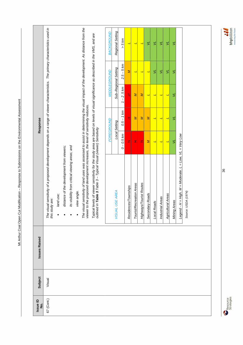
Mt A
rthu
r C
oal O
pen
Cut
Mod
ifica
tion
– R
espo
nse
to S
ubm
issi
ons
on th
e E
nviro
nmen
tal A
sses
smen
t
36
Issu
e ID
N
o.
Su
bje
ct
Issu
es R
aise
d
Res
po
nse
67 (
Con
t.)
Vis
ual
T
he v
isua
l sen
sitiv
ity o
f a p
ropo
sed
deve
lopm
ent d
epen
ds o
n a
rang
e of
vie
wer
cha
ract
eris
tics.
The
prim
ary
char
acte
ristic
s us
ed in
th
is s
tudy
are
:
• la
nd u
se;
• di
stan
ce o
f the
dev
elop
men
t fro
m v
iew
ers;
• its
vis
ibili
ty fr
om c
ritic
al v
iew
ing
area
s; a
nd
• vi
ew a
ngle
.
The
vis
ual s
ensi
tivity
of l
and
uses
was
ass
esse
d to
ass
ist i
n de
term
inin
g th
e vi
sual
impa
ct o
f the
dev
elop
men
t. A
s di
stan
ce fr
om th
e vi
ewer
to th
e pr
opos
ed d
evel
opm
ent i
ncre
ases
, the
leve
l of s
ensi
tivity
red
uces
.
Typ
ical
leve
ls o
f vie
wer
sen
sitiv
ity fo
r th
e st
udy
area
are
bas
ed o
n le
vels
of v
isua
l sig
nific
ance
as
desc
ribed
in th
e V
MS
, and
are
ou
tline
d in
Tab
le 3
.Tab
le 3
– T
ypic
al V
isua
l (vi
ewer
) S
ensi
tivity
VIS
UA
L U
SE
AR
EA
FO
RE
GR
OU
ND
M
IDD
LEG
RO
UN
D
BA
CK
GR
OU
ND
Loca
l Set
ting
Sub
–Reg
iona
l Set
ting
Reg
iona
l Set
ting
0 –
0.5
km
0.5
– 1
km
1 –
2 .5
km
2.
5 –
5 km
>
5 k
m
Res
iden
ces/
Tow
nshi
ps
H
H
H
M
L
Tou
rist/R
ecre
atio
n A
reas
H
M
M
L
L
Hig
hway
s/T
ouris
t Rou
tes
H
M
M
L L
Sec
onda
ry R
oads
M
M
L
L V
L
Loca
l Roa
ds
L L
L V
L V
L
Indu
stria
l Are
as
L L
L V
L V
L
Agr
icul
tura
l Are
as
L L
L V
L V
L
Min
ing
Are
as
VL
VL
VL
VL
VL
Lege
nd -
H =
Hig
h, M
= M
oder
ate,
L =
Low
, VL
= V
ery
Low
Sou
rce:
US
DA
(19
74)

Mt A
rthu
r C
oal O
pen
Cut
Mod
ifica
tion
– R
espo
nse
to S
ubm
issi
ons
on th
e E
nviro
nmen
tal A
sses
smen
t
37
Issu
e ID
N
o.
Su
bje
ct
Issu
es R
aise
d
Res
po
nse
68
Vis
ual
Con
cern
was
rai
sed
rega
rdin
g th
e us
e of
the
2009
Con
solid
atio
n P
roje
ct E
A v
iew
poin
ts fo
r th
e M
odifi
catio
n vi
sual
as
sess
men
t, an
d th
at
addi
tiona
l vie
wpo
ints
sh
ould
be
asse
ssed
from
th
e D
arle
y “W
oodl
ands
” pr
oper
ty.
The
Mod
ifica
tion
nece
ssar
ily p
rovi
des
a co
mpa
rison
aga
inst
the
Con
solid
atio
n P
roje
ct E
A in
all
envi
ronm
enta
l fac
ets,
in o
rder
to
quan
tify
the
incr
emen
tal e
nviro
nmen
tal i
mpa
cts
asso
ciat
ed w
ith th
e M
odifi
catio
n. T
his
is to
ena
ble
gove
rnm
ent a
nd c
omm
unity
st
akeh
olde
rs to
app
reci
ate
the
scal
e of
cha
nges
rel
evan
t to
the
Mod
ifica
tion
agai
nst t
he e
xist
ing/
appr
oved
Mt A
rthu
r C
oal m
ine.
In
rela
tion
to W
oodl
ands
Stu
d, it
is u
nder
stoo
d th
at th
e vi
ewpo
int n
ear
the
entr
y to
the
stud
was
sel
ecte
d as
it w
as a
clo
se a
s po
ssib
le to
th
e ho
mes
tead
with
out b
eing
abl
e to
gai
n ac
cess
into
the
prop
erty
itse
lf, a
nd p
ositi
oned
mor
e to
the
nort
h to
avo
id th
e bl
ocki
ng o
f vie
ws
to th
e si
te b
y in
terv
enin
g to
pogr
aphy
to th
e so
uth.
Giv
en th
at th
e le
vel o
f vis
ual c
hang
e as
soci
ated
with
the
Mod
ifica
tion
is v
ery
low
or
non-
appa
rent
from
this
loca
tion,
furt
her
inve
stig
atio
n be
yond
that
alre
ady
unde
rtak
en is
not
war
rant
ed.
69
Vis
ual
Con
cern
was
rai
sed
whe
ther
Fig
ures
4 a
nd 5
in
the
Land
scap
e an
d V
isua
l Im
pact
Ass
essm
ent
(App
endi
x H
) ar
e ac
cura
te.
HV
EC
and
Urb
is h
ave
revi
ewed
thes
e fig
ures
and
con
firm
thei
r ac
cura
cy.
Mt Arthur Coal Open Cut Modification – Response to Submissions on the Environmental Assessment
38
3 PART B - RESPONSES TO GOVERNMENT SUBMISSIONS Responses to issues raised by Government stakeholders are provided in the subsections below.
3.1 NSW Health Concern Raised:
Therefore proponent should demonstrate that the mitigation measures implemented throughout their operation including this project will result in a feasible net reduction in PM2.5 to the air-shed impacting on the Muswellbrook population.
HVEC Response: As stated in Section 8.7 of Appendix F of the EA [emphasis added]:
A comparison of the annual and maximum 24-hour PM10 concentration results for the Modification with the corresponding years in the 2009 EA is shown in Table 8.10. The comparison focused on PM10 because the majority of the exceedances predicted are of the 24-hour average PM10 criterion. The modelling predictions show that annual and maximum 24-hour PM10 average concentrations are lower at the majority of the residences compared to the 2009 EA. In particular, Residences 91, 94, 183, 184c, 187, 200, 201 and 226 are below the 24-hour average PM10 criterion of 50 μg/m3 for the modelling predictions for the Modification. This is partly a result of continual efforts by Mt Arthur Coal Mine to implement controls to reduce dust emissions since 2009. Specifically these include water application while drilling and application of water to ROM stockpiles. Additionally, the changes to the mine plans compared to the 2009 EA have also helped improve dust impacts at some of the residences.
As PM2.5 concentrations are a subset of PM10 concentrations, it follows that as there is a reduction in PM10 concentrations there would be a corresponding reduction in PM2.5 concentrations at the majority of the residences relative to the 2009 EA. Concern Raised:
Based on the information provided in tables 8.1 - 8.6 of appendix F, it appears that the existing annual average PM2.5 concentration is assumed to be 5 mcg/m3. However, there is no explanation as to how this value was derived, and table 4.7 of appendix F shows that annual average PM2.5 levels in nearby Muswellbrook are in the range 8 - 9 mcg/m3…Therefore, it is recommended that the proponent provides detailed explanation of how the existing PM2.5 level was estimated.
HVEC Response: A background annual average PM2.5 of 5 μg/m3 has been assumed for the Air Quality and Greenhouse Gas Assessment. Section 5.2 of Appendix F of the EA provides an explanation as to how this background level was derived from PM10 monitoring undertaken in the surrounds of the Mt Arthur Coal mine [emphasis added]:
Limited PM2.5 concentration data are available in the vicinity of the Modification. Co-located monitors for PM10 and PM2.5 have been operated by the EPA at a number of locations in the Hunter Valley since end of 2010 … The average ratio of PM2.5/PM10 across all EPA monitoring sites is 0.40. As discussed in Section 4.3.4, EPA monitors use different monitoring methods for measuring PM10 and PM2.5 which results in ratios of PM2.5/PM10 greater than 1 (particularly during the winter months). Excluding winter months and instances where PM2.5/PM10 ratios are greater than 1, the average ratio of PM2.5/PM10 at the Muswellbrook EPA monitor is 0.38. In order to correspond with the BAM PM2.5 monitoring period, the average PM10 concentration measured across the Mt Arthur Coal TEOMs in 2011 is 13 µg/m3 (Table 4.5). Using this ratio and applying it to the annual average PM10 concentration of 13 µg/m3, the annual average PM2.5 background concentration would be approximately 5 µg/m3. This accounts for >60% of the annual PM2.5
ARS of 8 μg/m3.

Mt Arthur Coal Open Cut Modification – Response to Submissions on the Environmental Assessment
39
Concern Raised: …. it is recommended that the proponent illustrates the sensitivity of the impact assessment to assumptions about control efficiency by conducting an analysis using lower values.
HVEC Response: Consistent with the Consolidation Project, the Modification air quality assessment assumed 85 percent haul road dust control to be achieved through haul road watering and the use of chemical dust suppressants. Sinclair Knight Merz (2005) derived an equation that shows control benefits up to 95 percent for increased watering. This finding is confirmed by Buonicore and Davis (1992) who state that a level of control of 90 percent is expected to be achieved by increasing the application rate of water and/or through the use of dust suppressants. The study states that 90 percent control can only be maintained provided the moisture content of the surface material is approximately 8 percent (refer to Figure 8.1). The above observations are further reinforced within US EPA (2006). Figure 8.2 (after US EPA, 2006) presents the relationship between the instantaneous control efficiency due to watering and the resulting increase in surface moisture. The moisture ratio “M” (shown on the x-axis) is calculated by dividing the surface moisture content of the watered road by the surface moisture content of the uncontrolled road.
Figure 8.1: Watering Control Effectiveness for Unpaved Roads (Buonicore and Davis, 1992)
Figure 8.2: Watering Control Effectiveness for Unpaved Travel Surfaces (US EPA, 2006)

Mt Arthur Coal Open Cut Modification – Response to Submissions on the Environmental Assessment
40
US EPA, 2006 states that as the watered surface dries, both the ratio M, and the predicted instantaneous control efficiency (shown on the y-axis), decrease. The figure shows that between the uncontrolled surface moisture content and a value twice as large, a small increase in moisture content results in a large increase in control efficiency. Beyond that, control efficiency improves slowly with increased moisture content. For example, if the uncontrolled surface moisture content was 2 percent, and the addition of water increased this to 4 percent, a 75 percent reduction in emissions could be expected. However, increasing the surface moisture content further to 6 percent would only result in an additional 5 percent control. Notwithstanding the above, it is clear from Figure 8.2, that, while returns diminish beyond 75 percent control, theoretical control efficiencies from the application of water alone may reach up to 95 percent. The 85 percent control applied for the Modification is clearly within these upper and lower control levels. As part of the EPA’s Pollution Reduction Programs which are currently being implemented across NSW, HVEC will be required to monitor and report on haul road control efficiencies. In addition, the modelling predictions show that annual and maximum 24-hour PM10 average concentrations are marginally lower at the majority of the residences compared to the Consolidation Project EA. In particular, eight residences are below the 24-hour average PM10 criterion of 50 µg/m3 for the modelling predictions for the Modification compared to the Consolidation Project EA. Therefore, further sensitivity analysis on haul road control effectiveness is not warranted. Concern Raised:
A number of residences outside the Zone of Acquisition are predicted to be exposed to an increase in annual average PM2.5 concentration of 3 mcg/m3 as a result of this project. Any increase in long-term exposure to PM2.5 is associated with adverse health effects. An increase of this magnitude presents a significant increase in risk for individuals residing at these properties and it is recommended that the proponent considers including them in the acquisition zone.
HVEC Response: There are no predicted exceedances of the Modification alone annual average or 24-hour PM2.5 criteria, outside of the affectation zone. It is relevant to note that Section 8.7 of Appendix F of the EA compares the impacts associates with the Modification EA compared to the 2009 EA [emphasis added]:
A comparison of the annual and maximum 24-hour PM10 concentration results for the Modification with the corresponding years in the 2009 EA is shown in Table 8.10. The comparison focused on PM10 because the majority of the exceedances predicted are of the 24-hour average PM10 criterion. The modelling predictions show that annual and maximum 24-hour PM10 average concentrations are lower at the majority of the residences compared to the 2009 EA. In particular, Residences 91, 94, 183, 184c, 187, 200, 201 and 226 are below the 24-hour average PM10 criterion of 50 μg/m3 for the modelling predictions for the Modification. This is partly a result of continual efforts by Mt Arthur Coal Mine to implement controls to reduce dust emissions since 2009. Specifically these include water application while drilling and application of water to ROM stockpiles. Additionally, the changes to the mine plans compared to the 2009 EA have also helped improve dust impacts at some of the residences.
As PM2.5 concentrations are directly proportional to a subset of PM10 concentrations, it follows that there would be a corresponding reduction in PM2.5 concentrations at the majority of the residences relative to the 2009 EA. Concern Raised:
It is not clear in the EA whether assistance in the form of air quality mitigation measures that are provided for privately owned residences are also provided for tenants in mine-owned properties …The EA states that a number of residences that were potentially affected by noise and blasting have been purchased. However, it is unclear from the EA whether these properties receive noise mitigation measures to protect current or future tenants.

Mt Arthur Coal Open Cut Modification – Response to Submissions on the Environmental Assessment
41
HVEC Response: HVEC regularly informs tenants occupying HVEC-owned dwellings of project activities and monitoring results. Where relevant, references to the potential for elevated noise and air quality particulate matter concentrations are made in the relevant rental agreements. HVEC would consider noise mitigation measures at HVEC-owned dwellings on a case-by-case basis. Concern Raised:
Any modelling beyond a 10 year timeline could consider that the annual average PM10 and PM2.5 goal may have been reduced considerably over that time period.
HVEC Response: The Air Quality and Greenhouse Gas Assessment (Appendix F of the EA) has been undertaken in accordance with the Approved Methods and includes the assessment of PM2.5 and PM10. This includes air quality modelling predictions for year 2026 of the proposed Modification and comparison against relevant EPA criteria. These criteria are generally consistent with the existing Project Approval (09_0062). Concern Raised:
It would be appropriate to have an independent assessment of the community satisfaction with the stakeholder engagement program.
HVEC Response: HVEC will continue to implement the following as part of the stakeholder engagement program: • Mt Arthur Coal Community Consultative Committee;
• website and community response line;
• Community Matters Newsletter;
• community investment; and
• Sustainable Communities Project, including community perceptions surveys. Given the relatively low number of objections received from members of the public in relation to the Modification, HVEC considers the above programs to be sufficient mechanisms for assessing community satisfaction and will implement any changes to improve community satisfaction, if necessary.
3.2 Dams Safety Committee Concern Raised:
The proposed modification (09_0062 MOD 1) project area occurs in part within the Notification Area of Mt Arthur Tailings Storage Facility (Figure 1). Mt Arthur Tailings Storage Facility is a prescribed dam that has been assessed as having a consequence of High A due to the potential for loss of life in the event of the dams failure (Mt Arthur's administration buildings are positioned at the toe of the one of the dams major embankments).
HVEC Response: HVEC notes the Dams Safety Committee (DSC) comments and will continue to adhere to the conditions and requirements relating to the Mt Arthur Tailings Storage Facility.

Mt Arthur Coal Open Cut Modification – Response to Submissions on the Environmental Assessment
42
Concern Raised:
At this stage then the DSC has no comments on the project other than reiterating to the mining company that should the proposed activities within the Notification Area expand to include mining, then endorsement of the DSC must be sought prior to this occurring.
HVEC Response: HVEC notes the DSC comments and would seek the endorsement of the DSC, should mining be proposed within the Notification Area in the future.
3.3 Department of Trade, Investment, Regional Infrastructure and Services – Division of Resources and Energy
Concern Raised:
1. The Proponent must prepare and implement a Rehabilitation Plan to the satisfaction of the Director General of Department of Trade & Investment, Regional Infrastructure & Services. The Rehabilitation Plan must:
a. be prepared in accordance with DRE guidelines and in consultation with relevant agencies and stakeholders;
b. be submitted and approved by the Director General of Department of Trade & Investment, Regional Infrastructure & Services prior to the commencement of construction;
c. address all aspects of rehabilitation and mine closure, including final landuse assessment, rehabilitation objectives, domain objectives, completion criteria and rehabilitation monitoring.
HVEC Response: HVEC notes the Department of Trade, Investment, Regional Investment and Services – Division of Resources and Energy (DTIRIS-DRE) comments and would review, and if necessary revise, the existing Biodiversity and Rehabilitation Management Plan (BRMP) to incorporate the Modification (prepared in accordance with Condition 44, Schedule 3 of Project Approval 09_0062), in consultation with DTIRIS-DRE.
3.4 Office of Environment and Heritage Concern Raised:
OEH was satisfied with most aspects of the Aboriginal cultural heritage assessment and actions, and recommends that management plans are updated frequently in line with on-going discussions with appropriate registered Aboriginal parties and new Aboriginal objects and sites uncovered during archaeological investigations. Similarly, OEH was satisfied with most aspects pertaining to threatened biodiversity. Further details, with recommended conditions of approval are provided in Attachment 1.
The Office of the Environment and Heritage (OEH) therefore recommends the following Conditions of Approval for the proponent for this Project and that the proponent must:
1. Develop appropriate management strategies with regards to the detection and subsequent
treatment of currently undetected Aboriginal objects and other cultural material within the development footprint.
2. Develop culturally appropriate management strategies to alleviate any likely or possible impact in consultation with the registered Aboriginal parties for the project and in compliance with the Ministers Condition of Approval.

Mt Arthur Coal Open Cut Modification – Response to Submissions on the Environmental Assessment
43
3. Complete and lodge an Aboriginal Site Impact Recording Form for all Aboriginal sites impacted by the modification project, and that this form must be submitted to OEH's Aboriginal Heritage Information Management System Registrar within three months of being impacted.
4. Develop any methodology for sub-surface excavation of any archaeological investigations in accordance with OEH's 'Code of Practice for Archaeological Investigations of Aboriginal Objects in NSW’ (2010).
5. Provide all registered Aboriginal parties with a fair, reasonable and timely opportunity to participate in developing methodologies for, and implementing sub-surface excavations of any archaeological investigation. The proponent must take accurate records of any such attendance by registered Aboriginal parties and outcomes of such meetings.
6. Record and manage any additional Aboriginal objects are [sic] uncovered during archaeological investigations or salvage programs in accordance with the requirements of sections 85A1(c) and 89A of the National Parks and Wildlife Act 1974, and include any such actions/procedures in the proposed updated Mt Arthur Coal Aboriginal Heritage Management Plan.
7. Update the existing Aboriginal Heritage Management Plan in consultation with the registered Aboriginal parties for the project to detail management and mitigation measures relevant to the modification area, including the management of any new sites or Aboriginal objects uncovered during any archaeological investigations.
8. Provide further details regarding a proposed salvage methodology for Aboriginal site 'Fairford 1', including details of appropriate cultural considerations any methodologies developed, the timing of the salvage program and a determination of the long-term arrangements for the care of the object to the registered Aboriginal parties and provide a summary of those discussions with OEH to show support by at the very least a majority of the registered Aboriginal parties for this salvage before it can go ahead.
HVEC Response: HVEC acknowledges the NSW Office of Environment and Heritage’s (OEH’s) points 1 to 8 and agrees to address these points within the Aboriginal Heritage Management Plan. In relation to point 8, this detailed description of the salvage methodology would be provided to OEH and Aboriginal stakeholders for comment prior to the proposed salvage of site Aboriginal Heritage Information Management System 37-2-00111 (Grinding Groove site). As disturbance of this site is not scheduled to occur until approximately 2022, sufficient time exists to plan and consult in regard to the proposed salvage. Concern Raised:
OEH notes that the proponent intends to find and secure all of the offset land for this project within 12 months of consent. In order to meet OEH's 'Principles for the use of biodiversity offsets in NSW' (OEH, 2011), offsets would need to be secured before work for the proposed modification commenced (if it is approved) …OEH therefore strongly recommends that all offsets are provided and secured before any works for this project can commence.
HVEC Response: HVEC notes the OEH’s comment and agrees that the offsets would be provided and secured within a reasonable timeframe, should the Modification be approved. Concern Raised:
OEH is therefore concerned that resources for revegetation and rehabilitation for the Mt Arthur Mine Site are not being best invested for long-term returns for the environment.

Mt Arthur Coal Open Cut Modification – Response to Submissions on the Environmental Assessment
44
There are also issues of edge effects, for example the modification project would see the high wall of the open pit eventually abut the Mt Arthur Conservation Area, which could alter the vegetation structure and composition (through increased drainage and increased wind speeds, for example) of vegetation on Mt Arthur. Similarly, OEH notes that other parts of the BHP-Billiton Project Area for the UHSA [Upper Hunter Strategic Assessment] occur along Saddlers Creek between the current and proposed offset areas. These too could lead to edge effects adversely affecting the vegetation in biodiversity offsets if any of those parts of the UHSA Project Areas are developed.
HVEC Response: HVEC is committed to providing biodiversity outcomes as part of mine rehabilitation. Figure 5-2 of the EA provides the Proposed Rehabilitation Plan and Offset Strategy for the Modification. As described in Table 4-13 of the EA, Modification rehabilitation areas would total some 2,642 ha. Edge effects associated with the existing/approved Mt Arthur Coal mine and the Modification around the Mt Arthur Conservation Area after rehabilitation can be conceptualised by comparing Figures 5-1 and 5-2 of the EA. From comparison of these figures, it is apparent that the final void water storage would be further away from the Mt Arthur Conservation Area for the Modification relative to the Existing/Approved operations; and a larger woodland corridor would be established as part of rehabilitation activities for the Modification. HVEC is a participant in the Upper Hunter Strategic Assessment (UHSA) process, which aims to improve biodiversity outcomes from coal mining proposals. Potential future mine disturbance areas provided as part of this process are conceptual, with greater definition of disturbance footprints to be determined as part of any future planning approval documentation. Some of the areas provided for the UHSA have been included in that process on a precautionary basis to ensure that any future linear infrastructure corridors are also covered. Offsets proposed as part of the Modification have been selected in consideration of their potential as future mining areas (i.e. to minimise potential for sterilisation of mineable coal resources). Beyond the Modification, HVEC’s future rehabilitation research, design, planning, approval and implementation is subject to the outcomes of the FLDP. The FLDP is a HVEC initiative to investigate, develop and deliver a more acceptable and integrated landform that is compatible with the surrounding natural landscape. The key objective of the FLDP is to develop a final landform that addresses stakeholder concerns, is safe and stable, and generates little or no impact on production or operational efficiencies during its development or ongoing maintenance. The FLDP focus areas include, but are not limited to: • macro and micro topographic relief research and geofluvial consideration;
• landform height and stability;
• dump development viability;
• hydrology;
• soil stability;
• erosion control;
• vegetation and ecosystem function design;
• visual relief and simulations; and
• noise and air quality consideration during dump development. It is anticipated that phase one (research and design options) of the FLDP would be completed in approximately 18 months. Following analysis of design options, consultation would be undertaken with key regulatory authorities and other stakeholders regarding the proposed changes to final landscape and landform resulting from the outcomes from the FLDP.
Mt Arthur Coal Open Cut Modification – Response to Submissions on the Environmental Assessment
45
Concern Raised:
Finally, OEH recommends that the monitoring programmes of offset lands already in place, and to be implemented across the new offsets for this project include appropriate statistical analysis of monitoring results. 'Analysis of Similarities' ('ANOSIM'), for example, or similar technique could be applied to assess the nature and extent of change between vegetation in fixed quadrats (e.g. Clarke 1993) before such changes are necessarily obvious to the human eye.
HVEC Response: As described in Section 5.1.9 of the EA, it is essential to monitor rehabilitation development and address rehabilitated areas not meeting the criteria presented in Tables 5-1 and 5-2 (of the EA). As such, identification of the need for maintenance is an important objective of the monitoring program and the continuous improvement process. Good initial planning and rehabilitation practice will minimise the need for remedial maintenance. Until mining leases are relinquished, broadscale field inspections will be undertaken of site-wide rehabilitated areas. These inspections will assess maintenance requirements, such as revegetation works, sedimentation and erosion control and site safety. Monitoring program results, maintenance activities, and any refinement of rehabilitation or monitoring methodology will be reported in the site’s AEMR. Further details on the monitoring, site security and maintenance programs are provided in the BRMP. In particular, the BRMP (HVEC, 2012) provides the following:
As a minimum, the long-term rehabilitation monitoring will:
• Compare monitoring results against rehabilitation objectives and targets;
• Identify possible trends and areas for improvement;
• Link to records of rehabilitation to determine causes and explain results;
• Assess effectiveness of environmental controls implemented;
• Where necessary, identify modifications required for the monitoring program, rehabilitation practices or areas requiring research;
• Compare flora species present against original seed mix and/or analogue sites;
• Assess vegetation health;
• Assess vegetation structure (upper, mid and lower storey); and
• Where applicable, assess the effectiveness of habitat creation for target fauna species.
Where necessary, rehabilitation procedures will be amended according to the above continuous improvement feed-back strategy and in line with continually improving rehabilitation standards. Details on the monitoring strategies include:
• Specifications for Ecosystem Functional Analysis or alternative assessment – Appendix 2;
• Visual Assessment of Revegetated Areas – Appendix 3; and
Assessment of Potential Carrying Capacity – Appendix 4.
Concern Raised:
The 'Additional Off-site Offset Area' is close to Muswellbrook township and adjacent to part of the Thomas Mitchell Drive Offset where OEH understands that Muswellbrook Shire Council is considering building a sewage treatment plant to service urban and industrial development in this area. OEH acknowledges that the offsets for the Mt Arthur Consolidation Project (PA 09_0062) do not need to be finalised until September 2014, and thus there may not be an issue with building on a proposed offset. However, the section of the proposed offset area that is to be developed will need to be offset. OEH recommends that this same situation is avoided with the offsets for the current proposal.
Mt Arthur Coal Open Cut Modification – Response to Submissions on the Environmental Assessment
46
OEH suggests that the proponent might consider offering the Thomas Mitchell Offset (and new offset) to Muswellbrook Shire Council for inclusion as 'Community Land' within Councils conservation reserve system managed as a 'natural area' under an appropriate plan of management. Appropriate funding could be transferred to Council to provide ongoing management of the land for conservation purposes. In this way Council rather than BHP Billiton would become the land manager for those particular offsets. Further, OEH recommends that the proponent maintain a dialogue with Council in relation to the placement of offsets, for example so that consideration can be given to Council's proposed local conservation corridors.
HVEC Response: A response regarding the MSC’s proposed STP is provided in the responses to MSC submissions below. HVEC would continue to consult with MSC in regard to the additional off-site offset and the Thomas Mitchell Drive offset areas. Concern Raised:
Given that this species [ Lobed Blue-grass (Bothriochloa biloba)] is currently only listed under Commonwealth legislation and some of the largest known sub-populations in the region would be cleared by this proposal, it appears prudent that this project is referred to the Commonwealth Department of Sustainability, Environment, Water, Population and Communities for its consideration and assessment for this species, as well as that of Box-Gum woodland.
HVEC Response: The Modification is planned to be referred to the Commonwealth Minister for Sustainability, Environment, Water, Population and Communities for consideration under the EPBC Act. Concern Raised:
OEH usually does not support such translocations due to the lack of guarantees of success, and also the risk of unforeseen consequences on resident subpopulations of Weeping Myall and Painted Donkey Orchid. OEH would only support such translocations if they are done in accordance with the 'Guidelines for the Translocation of threatened Plants in Australia' (Vallee et al., 2004) - in order to learn from the experience - and if they are supplemental to the provision of an appropriate offset.
HVEC Response: Hunter Eco (Appendix D of the EA) describes that an evaluation of whether or not the plants should be translocated would be made by an appropriately qualified person. If translocations are deemed appropriate, HVEC agrees to undertake the translocation in accordance with the 'Guidelines for the Translocation of Threatened Plants in Australia' (Vallee et al., 2004). Concern Raised:
OEH notes that the fauna survey for this project was conducted in late Autumn 2012 at a time when local minimum temperatures were, for all but one night, falling below 10 degrees centigrade. This raises the question of whether the surveys conducted were adequate to detect all threatened frogs and bats on the project area and proposed offsets.
HVEC Response: As described in Section 3 of Appendix D of the EA, many fauna surveys have been conducted for the Mt Arthur Coal mine in the past five years and since 2000. Previous surveys were used to obtain background data on fauna species likely to occur in the Modification area. As described in Table 14 of Appendix D of the EA, no threatened frogs are likely to occur in the Modification area due to the lack of suitable habitat. All threatened bat species with the potential to occur in the Project area were considered as part of the assessment as described in Table 14 and Section 7.4.9 of Appendix D of the EA.

Mt Arthur Coal Open Cut Modification – Response to Submissions on the Environmental Assessment
47
Concern Raised:
OEH therefore recommends that targeted surveys are conduction for both of these species [Pine Donkey Orchid and Dichanthium setosum] in the Rail loop area and in Box-Gum woodland prior to the commencement of development. Further, OEH recommends that such targeted surveys are conducted at a time of year when these species are most likely to be detectable.
HVEC Response: As described in Section 7.1.2 of Appendix D of the EA, a search was conducted for the Pine Donkey Orchid during its flowering season:
On 19 September 2012 the orchid was confirmed to be flowering in the A171 reserve so a search was conducted through Modification Areas B and C. No orchids were found.
As described in Section 8.1 of Appendix D of the EA, pre-clearance surveys are conducted within all patches of forest and woodland to be cleared. As required, HVEC agrees to undertake the pre-clearance surveys at a time of year when the Pine Donkey Orchid and Dichanthium setosum are most likely to be detectable (i.e. between September and October for the Pine Donkey Orchid and between December and February for Dichanthium setosum). Concern Raised:
That all biodiversity offsets are provided in accordance with OEH biodiversity offsetting principles (OEH, 2011), including securing the offsets prior to the start of development.
HVEC Response: HVEC notes the OEH’s comment and agrees that the offsets would be provided and secured within a reasonable timeframe, should the Modification be approved. Concern Raised:
That a targeted survey for the Pine Donkey Orchid (Diuris tricolor) is undertaken in the development footprint of the proposed upgrade of the rail loop and associated infrastructure and that those surveys are undertaken at an appropriate time to detect plants, such as when plants in local subpopulations of Pine Donkey Orchid along Thomas Mitchell Drive are flowering.
HVEC Response: As described above, pre-clearance surveys are conducted within all patches of forest and woodland to be cleared. As required, HVEC agrees to undertake the pre-clearance surveys at a time of year when the Pine Donkey Orchid is most likely to be detectable (i.e. between September and October). Concern Raised:
That the proponent also conduct a targeted survey for Bluegrass (Dichanthium setosum) in Box-Gum vegetation in the project area before any clearing commences; and if any plants are found in the development area that they are offset in accordance with OEH biodiversity offsetting policy.
HVEC Response: As described above, and consistent with the BRMP:
Pre-clearance surveys will be conducted within all patches of forest and woodland to be cleared and flora and fauna of conservation significance detected will be translocated into protected habitat.

Mt Arthur Coal Open Cut Modification – Response to Submissions on the Environmental Assessment
48
3.5 Department of Primary Industries Concern Raised:
Agricultural Land and Resources … the proponent has identified 2.4 ha of Biophysical Agricultural Land (BSAL) and stated that this is not applicable to the BSAL criteria due to the area being under 20ha. However, the 2.4 ha appears to be part of a significantly larger parcel of BSAL and therefore should be considered as BSAL. It should be noted that fertility ranking needs to be considered in terms of soil type as specified in Table 6 of the Interim protocol for site verification and mapping of BSAL.
HVEC Response: HVEC has identified and assessed 2.4 ha of BSAL within the Modification area as described in Section 4.3.1 of the EA:
Version 7 of the Draft (February 2013) Interim Protocol for Site Verification and Mapping of Biophysical Strategic Agricultural Land (NSW Government, 2013) describes that:
BSAL must have a contiguous area equal to or exceeding 20Ha which meets the verification criteria. The minimum area refers to the extent of the biophysical resource not the lot or holding size. Hence if the mining lease area or holding includes less than 20 Ha of BSAL but this BSAL is part of a larger contiguous mass that equals to or exceeds 20Ha then the land is regarded as BSAL. It is noted that the area to the immediate north of the potential BSAL (Figure 4-1) is associated with Hunter River alluvium. Whilst detailed site verification has not been undertaken on these adjacent areas, it is conservatively assumed that the BSAL is contiguous to the north (i.e. the 2.4 ha of BSAL in the Modification area is part of a larger contiguous mass that equals to or exceeds 20 ha).
As described in Section 4.3.1 of the EA, BSAL was defined by assigning a fertility ranking using soil parameters (e.g. pH, electrical conductivity, cation exchange capacity, nutrient levels etc) (GSS Environmental, 2012). Notwithstanding, it is noted that the soil types in this area are Red Chromosols and Brown Sodosols, which are of moderately low fertility according to Table 6 of the Interim protocol for site verification and mapping of BSAL, which would mean that the area would fail the BSAL criteria based on this methodology. Concern Raised:
Rehabilitation Strategy and Agriculture NSW DPI need to be satisfied that this land could be used for other land uses, particularly intensive cropping, if needed. The consequences of not utilising 33ha of Class II land in the north western corner for the mining project have not been articulated as a mitigation strategy. Retaining this small north western corner would overcome the issue of how to preserve high value agricultural land In addition, integration of this rehabilitation strategy with rehabilitation strategies of surrounding mines should be considered.
HVEC Response: There is no justification for excluding open cut mining from the Class II land identified, as described by NSW Department of Primary Industries (DPI). This is because: • the residual impacts of the Modification on Agricultural lands would be, at a state and regional level, very
minor;
• this land capability would be reinstated post-mining (i.e. after rehabilitation);
• the Class II land is within an existing mining lease and is owned by HVEC;
• limited agricultural activities are currently undertaken in this area; and
Mt Arthur Coal Open Cut Modification – Response to Submissions on the Environmental Assessment
49
• a very large economic benefit would be foregone and truncation of the Mt Arthur Coal mine life would occur, which would lead to loss of employment.
The Modification is expected to make a substantial contribution to the regional economy for the four years associated with the extension of approval to 2026, including: • $2,691 M in annual direct and indirect regional output or business turnover;
• $1,654M in annual direct and indirect regional value added;
• $326M in annual direct and indirect household income; and
• 2,715 direct and indirect jobs. Concern Raised:
1. Impacts on agricultural enterprises, including farm productivity, land values and flow on impacts to regional communities and the environment.
(a) Farm productivity
(b) …
(c) Downstream of the mine on Ramrod Creek are two current private water extraction entitlements licensed for irrigation. No information is provided on the potential impacts of the project on the continued availability of this water for potential irrigation use. Also see Point 2.
HVEC Response: As described in Section 4.5.2 of the EA, the decrease in catchment area and corresponding decrease in average flow rates are unlikely to have a material effect on riparian flows or licensed extraction from Ramrod Creek (Appendix C of the EA). Concern Raised:
(b) Land values
No information is presented in the AIS to assess the effects of the proposed development on local land values.
HVEC Response: There is no evidence that the Mt Arthur Coal mine has impacted adversely on local property values. Information released by the NSW Valuer General (Office of the NSW Valuer General, 2013)
Over the three year period since landowners in Muswellbrook LGA were issued with Notices of Valuation, the value of residential land has shown slight to moderate increases. The town of Muswellbrook has seen a constant level of residential development over the past few years, with newly released residential estates within Eastbrook Links, St Mary’s and Ironbark Ridge being sought after. … The value of rural land in Muswellbrook LGA has generally shown a slight to moderate increase despite a low volume of sales. Rural home site and hobby farm land has shown a slight to moderate increase over the three year period. There continues to be good demand for these properties, especially in the new estates closer to town and around the villages of Denman and Sandy Hollow, due to the influx of mine workers in the area. Village land values have generally shown a moderate increase, with the exception of land in Sandy Hollow and larger lots on the fringe Denman which has increase slightly. There has been an increase in demand due to coal mining activity and the affordability of housing in the villages compared to alternate locations such as Muswellbrook and Scone.

Mt Arthur Coal Open Cut Modification – Response to Submissions on the Environmental Assessment
50
Concern Raised:
(c) Flow on impacts to regional communities
No information is provided in the AIS for an assessment to be made. There is some discussion in the EIS about the cumulative impact of increasing mining developments in the area, but this discussion is not conclusive.
HVEC Response: Cumulative impacts are described in Section 3.4 of the AIS (Appendix A of the EA):
A number of existing and proposed mining projects are located within the general vicinity of the Modification area. The potential impacts of these projects on agricultural land are summarised below. Bengalla Coal Mine The Bengalla Coal Mine was approved in October 2011 and allows for the continued operation of the Bengalla Coal Mine to 2017. The Bengalla Mine Development Consent Modification EA (2010) (Bengalla Mining Company Pty Limited, 2010a) describes much of the land to be disturbed by this Modification as Class M land, which denotes that the land is currently being used for mining purposes. The remaining land is largely classified as Class VI land which is suitable for grazing only. Some area of Class IV (suitable for grazing with occasional cropping) and Class II land (suitable for a wide range of land uses) were also identified in the southern limits of the survey area, adjacent to the Hunter River Floodplain. In addition, the Bengalla 2011 Annual Environmental Management Report (Bengalla Mining Company Pty Limited, 2010b) describes the current operational areas at Bengalla Coal Mine as being located across predominantly Class IV and Class V grazing and agricultural land which has experienced extensive disturbance in the past. The majority of the leases have been cleared, grazed and were historically invaded by exotic grasses and shrubs. In February 2012, Bengalla Mining Company Pty Limited lodged a preliminary EA and request for DGRs with the DP&I for the Bengalla Continuation Project which would allow tailings emplacement for continued operations for a further 24 years. Drayton Mine Extension The Drayton Mine Extension was approved in June 2012 and allows for the continued operation of the Drayton Coal Mine to 2017. The Drayton Mine Extension EA (2007) describes the land within the MLs as small areas of undisturbed land in the North, South and East Pits were classified as suitable for grazing with occasional cultivation in respect to land capability (i.e. Classes IV and V) whilst all remaining areas were identified as unsuitable for rural production (i.e. Classes VII, VIII and M). Undisturbed land in the North, South and East Pits were classified as land suitable for grazing (i.e. Class 4) in respect to Agricultural Land Suitability, whilst all other areas were identified as land unsuitable for agriculture (i.e. Class 5) (Drayton Mine Extension EA, 2007). In March 2011, Anglo Coal lodged a preliminary environmental assessment and request for DGRs with the DP&I for the Drayton South Coal Project which would allow for continuation of mining at the Drayton Coal Mine and would extend operations to 2043. Mangoola Coal Project The Mangoola Coal Project was approved in February 2010 and allows for the continued operation of the Mangoola Coal Mine for 21 years. The Modification to Mangoola Coal Mine Plans and Relocation of 500kV Electricity Transmission Line describes majority of the land within the Proposed Disturbance Area as Class VI land, which is generally suitable for grazing with intensive management measures. The existing landscape is not suitable for cultivation owing to a combination of limitations of slope, subsoil instability and potential for dispersion and gully erosion. The small area of Class VIII land within the Proposed Disturbance Area is associated with the rocky outcrops around Anvil Hill.

Mt Arthur Coal Open Cut Modification – Response to Submissions on the Environmental Assessment
51
Mount Pleasant Project Modification The Mount Pleasant Project Modification was approved in September 2011 and allows for the continued operation of the Mount Pleasant Coal Mine to 2020. The Mount Pleasant Project Modification EA Report (EMGA Mitchell McLennan, 2010) describes the lands within the proposed action areas as grazing lands having a long history of agricultural use. Land to the west of the site is generally used for grazing with some agricultural activities undertaken.
Concern Raised:
2. Any water that is transferred or will no longer be available for agricultural use.
3. …
4. The proponent has indicated that their current water holdings are sufficient to meet their ongoing water demand, except in extreme drought years. No information is provided detailing water supply arrangements for extreme drought years.
HVEC Response: Management of water supply in drought conditions is addressed in the Surface Water Assessment by Gilbert & Associates in Section 4.2.2 of Appendix C of the EA:
Model predicted supply reliability assumes that the water supply system would be operated in an unchanged way even if water supplies were drawn down as a result of drought. In reality (as occurred in 2006 to 2007) HVEC would investigate and undertake measures such as purchase of additional Hunter River water entitlements on the open market or conversion of GSE to HSE (in accordance with NOW conversion rules). HVEC would use the water balance model to forecast water supply reliability on an on-going basis and assess the need to undertake such measures (refer Section 7 [of Appendix C of the EA]).
Concern Raised:
1. Impact on visual amenity, landscape values and tourism infrastructure relied upon by local and regional agricultural enterprises.
a) Visual amenity
b) …
c ) In Appendix H - Landscape and Visual Impact Assessment the proponent refers to a report that it committed to produce post-approval of a previous mining development application within the same mining complex in 2009.
d) …
e) No assessment can be made until this information is provided. HVEC Response: A Visual Impact Management Report was completed in May 2011 by AECOM. The report presents a range of visual mitigation options that could be employed. The Planning Approval focuses on mitigation of privately-owned land likely to experience significant visual impact. Letters have been sent to residents falling into this category, advising them of their entitlement to visual mitigation upon request. Visual mitigation has been employed at one privately-owned property to date. Off-site mitigation for non-residential visual impacts is limited to areas where HVEC owns the land or subject to agreement with private landholders. Progressive rehabilitation of mine disturbance areas has minimised the duration for which exposed slopes are viewed.
Mt Arthur Coal Open Cut Modification – Response to Submissions on the Environmental Assessment
52
Concern Raised:
f) Landscape values … h ) It is noted that the mine site is in an area where there are a number of mines in close
proximity, all of which are contributing to changes in the regional landscape. … j) Further information is required before an assessment can be made.
HVEC Response: The potential for the Modification to increase cumulative visual impacts is limited because of the limited nature of Modification visual impacts, as discussed in Section 4.11.2 of the EA:
Cumulative Impacts The assessment above has considered the existing landforms of nearby mining operations as they relate to visual sensitivity and visual impact. The assessment of cumulative visual impacts has also considered the combined effects of the Modification with the effects of the proposed Drayton South Coal Project. The proposed Drayton South Coal Project is located immediately south and adjacent to the Mt Arthur Coal mining and coal lease boundary. The Drayton South Coal Project Environmental Assessment (Hansen Bailey, 2012) indicates the following potential visual impacts: • the operational areas of the Drayton South Coal Project have been designed to remain behind existing
topography in order to conceal them from views at the most sensitive locations to the south.
• a visual bund would be constructed to screen views to the operational areas. Receivers located to the south of the Drayton South Coal Project including residences within Jerrys Plains, parts of Coolmore Stud and motorists on the Golden Highway would experience views of the visual bund during construction. During this time (estimated 16 months) the visual impacts for these areas would be high, reducing to moderate and then low for the remainder of the Drayton South Coal Project.
• since the dominant sources of light are located at the existing Drayton Mine, mobile equipment operating within the Drayton South Coal Project area would not significantly increase the overall diffuse light effect. Lighting impacts within the Drayton South Coal Project area would predominantly be caused by lights fitted to mobile equipment operating outside of active mining areas and in most cases, would be limited as a result of existing topography and vegetation.
The potential for cumulative visual impacts on sensitive viewpoints in the southern sector (including motorists on the Golden Highway) would be limited given the visual impacts assessed for viewpoints in these areas are low for both the Modification (Section 4.11.2) and proposed Drayton South Coal Project (following amelioration) (Hansen Bailey, 2012). Based on review of the above, no significant cumulative visual impacts are anticipated to arise from the coincident development of the Modification and the proposed Drayton South Coal Project, should it be approved. As described in Section 4.11.2, the nature of night lighting for the Modification is expected to be of a similar intensity when compared to the existing night lighting at the Mt Arthur Coal mine, although there is the potential for fixed and mobile lights to be visible from a wider area. If approved, the Drayton South Coal Project would result in limited night lighting impacts (caused by lights fitted to mobile equipment operating outside of active mining areas) that may result in limited cumulative night-lighting impacts. For example, there may be increased night time lighting effects on motorists using the Golden Highway.
The proposed Mangoola Extraction Rate Increase Modification would not change the existing mine disturbance boundary nor the final landform height. Therefore, cumulative visual issues relating to Mangoola are unlikely to change materially.
Mt Arthur Coal Open Cut Modification – Response to Submissions on the Environmental Assessment
53
Concern Raised:
k) Tourism infrastructure
…
m) … the HVEC Sustainable Communities Project (Table 4-24, page 4-17) indicate that the local community perceives that competition between tourists and mine workers for short-term accommodation is having a negative impact on the tourism industry. This issue should be explored.
HVEC Response: HVEC would consider contributing funds to an investigation of the impacts of the mining industry on tourism as part of its overall community development program, as described in Section 4.16.3 of the EA:
HVEC would continue to develop and run programmes that help in the recruitment of local labour and would work in partnership with Councils and the local community so that the benefits of the economic activity in the region are maximised and impacts minimised, as far as possible. In this respect, a range of impact mitigation and management measures are proposed including:
• continuation of the Community Development Fund to help benefit a wide range of community needs such
as education and training, community capacity building, environment, health, infrastructure projects, arts, sports and recreation;
• employment of local residents preferentially where they have the required skills and experience and demonstrate a cultural fit with the organisation; and
• purchase of local non-labour inputs to production preferentially where local producers can be cost and quality competitive.
HVEC has worked to respond to community feedback received on the priorities identified by preparing a Community Development Management Plan aimed at guiding its investment program over the next five years (BHP Billiton, 2011b). Through this program HVEC would work alongside the community to help strengthen overall capacity to respond to local issues.
Concern Raised:
2. Mitigation measures for minimising adverse impacts on agricultural resources, including agricultural lands, enterprises and infrastructure at the local and regional level.
… a) Agricultural lands
The proponent is consulting with adjacent landholders regarding a range of issues, such as visual impacts. For transparency, the proponent should provide details regarding the agreements made with these landholders.
HVEC Response: Section 1 of the EA provides details of issues raised during consultation with adjacent landowners. Private agreements between HVEC and landowners are confidential.
Mt Arthur Coal Open Cut Modification – Response to Submissions on the Environmental Assessment
54
Concern Raised:
b) Agricultural enterprises
Some discussion is provided and limited impact is expected. The project is part of ongoing mining expansion in the Muswellbrook area. A study should be undertaken to investigate the impacts on this expansion on agricultural tourism in the region.
HVEC Response: As described above, HVEC would consider contributing funds to an investigation of the impacts of the mining industry on tourism as part of its overall community development program. Concern Raised:
6. Documented consultation with adjoining land-users and Government Departments.
The proponent states that they have undertaken consultation, but insufficient information is provided in the AIS for any assessment to be made.
HVEC Response: Details of consultation undertaken for the AIS and more broadly for the EA are described in Section 1 of the EA.
3.6 Muswellbrook Shire Council Concern Raised:
Submissions in summary form
5. It is not reasonably open to the consent authority to determine that the Application falls within the jurisdictional power of section 75W.
HVEC Response: Section 75W applies to the Modification, as described in Section 6.1.1 of the EA:
The EP&A Act and EP&A Regulation set the framework for planning and environmental assessment in NSW. Modification of the Consolidation Project Approval (09_0062) for the Mt Arthur Coal Mine is sought under section 75W of Part 3A of the EP&A Act. Section 75W of the EP&A Act states:
75W Modification of Minister’s approval (1) In this section:
Minister’s approval means an approval to carry out a project under this Part, and includes an approval of a concept plan.
modification of approval means changing the terms of a Minister’s approval, including:
(a) revoking or varying a condition of the approval or imposing an additional condition of the approval, and
(b) changing the terms of any determination made by the Minister under Division 3 in connection with the approval.
(2) The proponent may request the Minister to modify the Minister’s approval for a project. The Minister’s approval for a modification is not required if the project as modified will be consistent with the existing approval under this Part.

Mt Arthur Coal Open Cut Modification – Response to Submissions on the Environmental Assessment
55
(3) The request for the Minister’s approval is to be lodged with the Director-General. The Director-General may notify the proponent of environmental assessment requirements with respect to the proposed modification that the proponent must comply with before the matter will be considered by the Minister.
(4) The Minister may modify the approval (with or without conditions) or disapprove of the modification.
Although Part 3A was repealed by the Environmental Planning and Assessment Amendment (Part 3A Repeal) Act 2011, section 75W continues to be the applicable modification provision for an approval such as the Consolidation Project Approval (09_0062). This is because Schedule 6A of the EP&A Act, which has the effect of making the Consolidation Project Approval (09_0062) a "transitional Part 3A Project", states that provisions in the repealed Part 3A, such as section 75W, continue to apply to and in respect of a "transitional Part 3A Project". Further, the DP&I advised BHP Billiton in a meeting held on 30 November 2011 that the DP&I was supportive in principle of a modification of Project Approval (09_0062) under section 75W of Part 3A of the EP&A Act. An outcome of the meeting was that DGRs for the Modification were sought by HVEC in February 2012 and were issued on 30 April 2012 (Attachment 2 [of the EA]).
Concern Raised:
6. The Project, taken individually and in aggregation with other proposals for road closures and road realignments will have a substantial impact on traffic efficiency in the local government area.
HVEC Response: It is noted that the RMS submission (dated 31 May 2013) relevantly provides:
RMS has reviewed the information provided, including the Road Transport Assessment prepared by GTA Consultants dated 19 December 2012. RMS has no objections to or requirements for the proposed modification as it is considered that the vehicular traffic generated by the proposed modification will not result in any significant impact on the classified road network.
Potential impacts associated with the Modification on the local road network are described in Section 4.13.2 of the Modification:
As the Modification would not change the currently approved operational or construction workforce, the key potential change to the local road network would be associated with the proposed new site access to the relocated explosives magazine and facilities to be located off Edderton Road. Approximately 60 permanent employees would work at the explosives magazine and facility. In addition, approximately 5,000 heavy vehicle movements per year would access the facility for the delivery of materials and consumables. These movements currently take place at the existing facility, which is accessed from the Mt Arthur Coal Mine Access Road off Thomas Mitchell Drive. GTA Consultants (NSW) Pty Ltd (Appendix K) assessed the potential impact of the Modification on the safety and efficiency of local roads (measured by the Levels of Service). Appendix K also considers cumulative road movements associated with nearby approved mining operations (Mt Pleasant Coal Mine and Mangoola Coal Mine Modification) and background traffic movement increases with time. Appendix K concludes that, with the proposed mitigation measures from the Consolidation Project EA in place, the Levels of Service of key intersections or roadways would not change due to the Modification. In addition, no specific safety implications were identified.
Mt Arthur Coal Open Cut Modification – Response to Submissions on the Environmental Assessment
56
In addition, the following traffic mitigation measures are proposed (Section 4.13.3):
HVEC would continue to implement the key mitigation measures identified in the Consolidation Project EA, namely fund the upgrade to:
• the intersection of Edderton Road and Denman Road;
• Thomas Mitchell Drive (in accordance with the terms of a planning agreement with MSC); and
• the intersection of Thomas Mitchell Drive and the New England Highway [completed]. The existing Road Management Plan would be reviewed and revised to incorporate the Modification.
Concern Raised:
6 The Project would contribute to particulate matter in the Upper Hunter air shed in circumstances where the air shed is at capacity insofar as the National guideline is concerned.
HVEC Response: An Air Quality and Greenhouse Gas Assessment (Appendix F of the EA) was undertaken in accordance with the DGRs and the Approved Methods for the Modelling and Assessment of Air Pollutants in NSW (Department of Environment and Conservation, 2005). The modelling predictions show that annual and maximum 24-hour PM10 average concentrations are marginally lower at the majority of the residences compared to the Consolidation Project EA. In particular, eight residences are below the 24-hour average PM10 criterion of 50 µg/m3 for the modelling predictions for the Modification compared to the Consolidation Project EA. This is partly a result of continual efforts by Mt Arthur Coal mine to implement controls to reduce dust emissions since 2009 (Appendix F of the EA). An indicative air quality emission contour for 24 hour PM10 for 2016 is provided on Figure 4-13 of the EA, with additional contours provided in Appendix F of the EA. Cumulative air quality modelling was undertaken for Years 2016, 2022 and 2026 of the Modification. Dust emissions from Bengalla Coal Mine, Drayton Coal Mine, Mount Pleasant Coal Mine and Mangoola Coal Mine were considered in the cumulative assessment. The cumulative modelling predicts no additional exceedances of the EPA’s annual average PM10, PM2.5 TSP on dust deposition criteria. The cumulative 24-hour average PM10
concentrations are heavily influenced by the prevailing wind speed and direction on a given day. An assessment of cumulative 24-hour PM10 is provided in the Air Quality and Greenhouse Gas Assessment (Appendix F of the EA). A review of the current dust control strategies used at Mt Arthur was undertaken as part of the Assessment of Coal Mine Particulate Matter Control Best Practice Pollution Reduction Program (BHP Billiton, 2012b). This review determined that HVEC employs a significant number of best practice measures to reduce particulate emissions from coal mining activities. These measures are described in the AQGGMP. In particular, HVEC operates a proactive dust management system which uses real-time air quality monitoring. This system involves alarms which, when triggered, invoke additional dust management controls. In summary, no privately-owned residences are anticipated to be impacted by dust levels exceeding the annual average PM10 criterion, that are not already within the HVEC or Mt Pleasant Zone of Acquisition (Appendix F of the EA). HVEC would continue implement these mitigation measures for the Modification.

Mt Arthur Coal Open Cut Modification – Response to Submissions on the Environmental Assessment
57
Concern Raised:
8. Council had not been fully consulted on the modification. The Proponent and Council have been in lengthy and detailed discussions about the status of the Thomas Mitchell Drive Offsite Offset Area.
HVEC Response: As outlined in Section 1.3.2 of the EA, In January 2012, HVEC met with the MSC to discuss the Modification. The MSC were provided with a briefing and information sheet. In May 2012, HVEC held a meeting with the MSC to provide an update on the Modification and to discuss final landform concerns raised by MSC. In July 2012 MSC representatives met with HVEC to discuss Modification offsets and potential impacts on the draft Muswellbrook Land Use Plan. In October 2012, HVEC provided an update on the Modification to representatives of MSC. Key aspects discussed by the MSC included: • road traffic and the increase in rail movements (Sections 4.13 and 4.14 of the EA);
• final void management (Section 5 of the EA);
• air quality monitoring and cumulative impacts (Section 4.8 of the EA); and
• local biodiversity offset areas (Section 4.6.4 of the EA). In addition to the above, HVEC and MSC are currently negotiating an extension of the existing Voluntary Planning Agreement to cater for the Modification. A response in relation to the Thomas Mitchell Drive offsite offset area is provided below. Concern Raised:
Justification 10. It is understood that the proposal to emplace overburden in the conveyor corridor was not
contemplated at the time of the 2009 Consolidation Application because of a power line that runs through the corridor. The alternative route for the power line could not be determined in 2009. The relocation of this power line is not identified in the application.
HVEC Response: The existing 132 kilovolt (kV) Electricity Transmission Line (ETL) between Singleton and Muswellbrook (owned by Ausgrid) is partly located within the conveyor corridor and would need to be relocated prior to the emplacement of overburden within the ETL’s easement. HVEC has consulted extensively with Augsrid over the last two years in relation to the conveyor corridor overburden emplacement. In particular, HVEC and Ausgrid have identified various options for the ETL’s relocation. Several options have been identified and discussions with Ausgrid are ongoing. The relocation of the 132 kV ETL would be undertaken subject to separate approvals.
Mt Arthur Coal Open Cut Modification – Response to Submissions on the Environmental Assessment
58
Concern Raised:
14. Those discussions relate to the need for Council to provide critical community infrastructure within the existing TMDOA. The infrastructure required includes:
(a) a trunk main for sewer reticulation of the Thomas Mitchell Drive Industrial Estate; …
(c) a replacement Sewage Treatment Plant (STP) to facilitate population expansion within the town driven by mining related growth;
…
16. The Part 3A Environmental Planning and Assessment Act 1979 Project Approval (09_0062, Open Cut Expansion Project) ("the Project Approval") has proven to impact upon Council's ability to properly provide for infrastructure in this area. Negotiations for the provision of the sewer trunk main connecting the existing STP with the Thomas Mitchell Drive industrial estate remain unresolved, although Council is confident that resolution is imminent.
HVEC Response: A full response relating to the MSC’s proposed STP is provided below. Concern Raised: Road Closures
19. While the Application refers to the "realignment" of Edderton Road, the Proponent does not, in fact, propose a realignment at all (a process which realigns the road with its road reserve) but rather a road closure and the gazettal of a new road.
HVEC Response: The realignment of Edderton Road is approved under the existing Project Approval (09_0062). The realignment will occur to the satisfaction of the MSC in accordance with Condition 47, Schedule 3. Concern Raised:
Long term security
22. Despite no specific reference to any particular long term security mechanism in either the Project Approval or the Biodiversity and Rehabilitation Management Plan, it is understood the Proponent is considering a Biodiversity Banking Agreement under Part 7A of the Threatened Species Conservation Act 1995.
23. Council is concerned that the long term security options should not exclude the potential for
infrastructure in this area. … 26. The long term security mechanism should provide for these eventualities and allow for the
appropriate development of the town. Extension area and Growth Corridor
27. … The Strategy has identified the need for a South Muswellbrook Growth Corridor.
…
Condition 37 Offsite Offset Area

Mt Arthur Coal Open Cut Modification – Response to Submissions on the Environmental Assessment
59
28. The Growth Corridor includes the proposed Condition 37 additional offset land. The additional land also abuts existing or potential residential developments.
Land excised for Replacement Muswellbrook Sewerage Treatment Plant
…
31. Council has identified the preferred site for its proposed STP located on RU1 zoned land that is currently subject to the Project Approval for Mt Arthur Coal, which conceptually designates the land as a Biodiversity Offset.
… 35. Council and the Proponent have received advice from NSW Planning and Infrastructure
indicating that to proceed further with the development of the STP, a modification of the Mt Arthur Coal Project Approval is required.
36. NSW Planning and Infrastructure has advised that consideration of a request to modify the
existing conditions of the Project Approval will be considered at the request of Council as part of this submission to the Mount Arthur Coal Modification 1 proposal.
37. Accordingly, Council requests a modification to the conditions of the Project Approval, as
part of the Mt Arthur Coal Modification 1 application, insofar as they would excise that land identified in the Council's survey for the construction of the replacement STP and all associated infrastructure, including freehold land transfers and easements as required.
HVEC Response: As described in MSC’s submission, MSC has identified an area of land within HVEC owned land and within the Thomas Mitchell Drive offset area where a STP is proposed. HVEC acknowledges MSC’s STP proposal and notes that the proposal would need HVEC to agree to an arrangement regarding the use of HVEC owned land for this purpose and would require DP&I to excise this land from the existing Thomas Mitchell Drive offset area (as it is currently described in Condition 36, Schedule 3 of Project Approval 09_0062). Management plans have been approved for Thomas Mitchell Drive offset area (biodiversity and Aboriginal). However a formal conservation agreement (i.e. for the long term security of the offset) is pending. HVEC would be amenable to the excision of the STP land from the Thomas Mitchell Drive Offset Area, as requested in MSC’s submission, subject to any new or revised condition of approval stipulating that the offset for the loss of this portion of the Thomas Mitchell Drive offset area is established with a ratio of 1:1 (i.e. for every hectare excised, HVEC would provide a hectare of additional offset) at a location to be determined by HVEC. HVEC would continue to negotiate with MSC regarding the STP and the use of HVEC-owned land for biodiversity offsets. Concern Raised:
Rail Loop 42. The existing rail spur line and the rail loop are not necessarily wholly within the colliery
holding.
…
43. The Colliery Holding is also the Environmental Protection Licence (EPL) boundary. Where the rail line and/or loop is beyond the Colliery holding, it will not be included in the EPL. Therefore, Council becomes the Appropriate Regulatory Authority under the Protection of the Environmental Operations Act 1997, as the rail spur itself is not a Scheduled Activity.

Mt Arthur Coal Open Cut Modification – Response to Submissions on the Environmental Assessment
60
HVEC Response: HVEC would continue to seek to achieve the noise criteria relating to the Antienne Rail Spur and other noise obligations under the Protection of the Environmental Operations Act 1997. Concern Raised:
50. …
The application does not include a detailed landform design identifying slope aspects, and grade or heights of land forms, all of which would be necessary to be compatible with viable grazing lands. It is not possible to determine if the allocation of pasture land or tree planting areas, would be consistent with Council's Land Use Development Strategy (coal mining component).
HVEC Response: Section 5 of the EA provides a Rehabilitation Strategy for the Modification. Essentially, the rehabilitation strategy for the Modification is to be consistent with the existing and approved strategy where possible, with the following exceptions: • Saddlers final void would be filled in under the Modification as a result of continued investigation by HVEC.
• Additional offset areas would be incorporated into the existing Saddlers Creek offset area.
• Reclassification of some Post Mined Lands – Pasture to Post Mined Lands – Woodland would occur.
• Reclassification of some Post Mined Lands – Woodland to Post Mined Lands – Pasture would occur.
• Following completion of mining, Whites Creek would be re-established to drain off site in accordance with existing conceptual rehabilitation principles.
Figure 5-2 (in Section 5 of the EA) shows the proposed rehabilitation concepts, including those portions of the rehabilitation areas that are proposed to be rehabilitated to pasture and woodland. Concern Raised:
Highbrook Estate
51. Figure 4-14 shows noise contours and indicates that Highbrook Estate (lot 1722 DP 829367 south of Highbrook Park) falls within 40-35dB contours. The application indicates that the land is held by Council. However this land was sold to a private developer in February 2013 and has development consent to develop 81 residential lots.
52. Noise assessment for this area must consider that the land is likely to be developed for
residential purposes. HVEC Response: It is noted that the sale of lot 1722 Deposited Plan 829367 by MSC to private developers occurred after the Noise and Blasting Assessment (Appendix G of the EA) was completed. Notwithstanding, from review of the receiver zones, this lot is located in receiver zone E (refer to Figure 4-1 of Appendix G), meaning that dwellings within this zone would have an equivalent continuous noise level (15 minutes) noise criteria of 39 dBA. From review of the Modification noise contours (Appendix D of Appendix G of the EA), the 39 dBA criteria would be achieved at this location.
Mt Arthur Coal Open Cut Modification – Response to Submissions on the Environmental Assessment
61
Concern Raised:
Roads
53. Council will not support an access to the mine from Edderton Road, whether the road is on its present alignment or on another alignment.
54. Council opposes the relocation of the Explosives Magazine and Facilities being accessed from
Edderton Road. The road is not suitable for the proposed traffic. HVEC Response: It is noted that the RMS submission (dated 31 May 2013) relevantly states:
RMS has reviewed the information provided, including the Road Transport Assessment prepared by GTA Consultants dated 19 December 2012. RMS has no objections to or requirements for the proposed modification as it is considered that the vehicular traffic generated by the proposed modification will not result in any significant impact on the classified road network.
Potential impacts associated with the Modification on the local road network are described in Section 4.13.2 of the EA as follows:
As the Modification would not change the currently approved operational or construction workforce, the key potential change to the local road network would be associated with the proposed new site access to the relocated explosives magazine and facilities to be located off Edderton Road. Approximately 60 permanent employees would work at the explosives magazine and facility. In addition, approximately 5,000 heavy vehicle movements per year would access the facility for the delivery of materials and consumables. These movements currently take place at the existing facility, which is accessed from the Mt Arthur Coal Mine Access Road off Thomas Mitchell Drive. GTA Consultants (NSW) Pty Ltd (Appendix K) assessed the potential impact of the Modification on the safety and efficiency of local roads (measured by the Levels of Service). Appendix K also considers cumulative road movements associated with nearby approved mining operations (Mt Pleasant Coal Mine and Mangoola Coal Mine Modification) and background traffic movement increases with time. Appendix K concludes that, with the proposed mitigation measures from the Consolidation Project EA in place, the Levels of Service of key intersections or roadways would not change due to the Modification. In addition, no specific safety implications were identified.
Specifically in relation to the relocated explosives facility, GTA Consultants has reviewed the existing road and intersection traffic conditions and modelled the change in performance of this infrastructure and relevantly concludes:
The proposal by HVEC to construct a new explosives storage facility off Edderton Road for the Mt Arthur Coal Mine would have an acceptable level of impact on the operation of the surrounding road system.
In addition, the following traffic mitigation measures are proposed (Section 4.13.3):
HVEC would continue to implement the key mitigation measures identified in the Consolidation Project EA, namely fund the upgrade to:
• the intersection of Edderton Road and Denman Road;
• Thomas Mitchell Drive (in accordance with the terms of a planning agreement with MSC); and
• the intersection of Thomas Mitchell Drive and the New England Highway [completed].
The existing Road Management Plan would be reviewed and revised to incorporate the Modification.

Mt Arthur Coal Open Cut Modification – Response to Submissions on the Environmental Assessment
62
Concern Raised:
55. There appears to be no assessment of:
(a) the construction traffic generated and traffic impacts of the widening of the rail bridge over Thomas Mitchell Drive;
… HVEC Response: It is noted that the RMS submission (dated 31 May 2013) relevantly provides:
RMS has reviewed the information provided, including the Road Transport Assessment prepared by GTA Consultants dated 19 December 2012. RMS has no objections to or requirements for the proposed modification as it is considered that the vehicular traffic generated by the proposed modification will not result in any significant impact on the classified road network.
As discussed in Section 4.13.3 of the EA, the existing Road Management Plan would be reviewed and revised to incorporate the Modification. It is anticipated that this would include specific measures for potential impacts on Thomas Mitchell Drive from construction activities associated with the rail loop duplication. Concern Raised:
55. There appears to be no assessment of: …
(b) increase in traffic on Council's Edderton Road and RMS's Denman Road;
… HVEC Response: Section 5.1 of Appendix K of the EA describes the background traffic growth that was assumed for the assessment of Modification road transport impacts:
Over time, traffic can be expected to grow in addition to the increases expected to result from the specific developments discussed in Section 4. Table 3.1 demonstrates how traffic on the RMS roads has varied from 1992 to 2010, which indicates that traffic volumes have generally increased gradually, with some fluctuations. It is noted that the Muswellbrook Western Roads Strategic Study applied an annual growth rate of 1.5% to background traffic, and that the Consolidation Project assessment assumed varying growth rates for different roads as advised by RMS: • Thomas Mitchell Drive 2%;
• Denman Road 2%;
• New England Highway north of Thomas Mitchell Drive 0.2%; and
• New England Highway south of Thomas Mitchell Drive -0.7%.
Based on the background traffic volumes presented for the Consolidation Project, forecasts for the future scenarios of relevance to the Modification have been extrapolated. These are presented in Table 5.1 and include traffic changes associated with background growth, the approved Consolidation Project (ceasing in 2022), the Drayton Coal Mine (approved 2008), Bengalla Wantana Extension (approved 2008) and Mangoola Coal Mine (approved 2007). Non-specific growth on Edderton Road is assumed to be 2% per annum above the volumes surveyed in 2012.

Mt Arthur Coal Open Cut Modification – Response to Submissions on the Environmental Assessment
63
Table 5.1: Background Growth in Daily Traffic (vehicles/day) Road Location 2014A 2019A 2022 2026
Thomas Mitchell Drive West of Mt Arthur Coal Mine 6,482 6,994 7,328 7,773
Thomas Mitchell Drive East of Mt Arthur Coal Mine 3,918 4,215 4,408 4,665
Denman Road North of Thomas Mitchell Drive
9,406 10,198 10,716 11,406
Denman Road South of Thomas Mitchell Drive
5,046 5,508 5,811 6,215
New England Highway
South of Muswellbrook 12,464 12,588 12,663 12,763
New England Highway
Ravensworth 12,633 12,231 11,998 11,687
Edderton RoadB South of Denman Road 1,051 1,153 1,213 1,294 A Source: Hansen Bailey (2009) except Edderton Road. B Surveyed 2012 volumes with 2% per annum growth.
Therefore, traffic increases on Denman Road and Edderton Road are considered in the Modification Road Transport assessment (GTA, 2012). Concern Raised:
55. There appears to be no assessment of:
…
(c) the existing pavement condition of Edderton Road; or
… HVEC Response: The condition of Edderton Road is described in Section 3.2 of the Road Transport Assessment (Appendix K of the EA) as follows:
Edderton Road Edderton Road is a local road under the control of Muswellbrook Shire Council. It runs in a north-south alignment through the Mt Arthur Coal Mine area and provides a road connection between Golden Highway in the south and Denman Road in the north. Edderton Road has a load limit restriction of a maximum of 14 t which relates to a causeway near its southern end. It has a sealed carriageway in the order of 6 to 7 m wide, and a posted speed limit of 100 km/h for approximately 3 km at its northern end, and approximately 5 km at its southern end. The speed limit along the remainder of Edderton Road is 80 km/h. The length with the lower speed limit is generally a somewhat lower standard of road, with more curves and poorer road surface on the edges of the carriageway. The intersection of Edderton Road and Golden Highway is proposed to be realigned as part of the Drayton South Coal Project, which includes realignment of approximately 7 km of Edderton Road (refer to Section 4.5). The existing intersection has no additional turn lanes on any of the approaches, with flaring of Edderton Road on its approach to Golden Highway. The intersection of Edderton Road and Denman Road does not have additional turn lanes on any of the approaches, with some flaring of Edderton Road on its approach to Denman Road.
Concern Raised:
55. There appears to be no assessment of:
…
(d) interaction of the construction traffic and the possible concurrent works being undertaken to upgrade Thomas Mitchell Drive.

Mt Arthur Coal Open Cut Modification – Response to Submissions on the Environmental Assessment
64
HVEC Response: The traffic implications associated with Modification construction activities are described in Section 2.5 of the Road Transport Assessment (Appendix K of the EA):
As part of the Modification, HVEC proposes to construct a relocated explosives magazine and storage facility on the western side of the site, which would be accessed from Edderton Road (Figure 2-1). With regard to road transport during the construction phase of the Modification, construction employees and deliveries to the worksite would generate traffic on the road system.
Other components of the Modification that require construction (rail loop duplication, additional offices, etc.) would involve construction employees accessing the site via the existing Thomas Mitchell Drive access road. In practice, these construction employees would not be discernible from the construction workforce associated with the existing approved Consolidation Project. As the impacts associated with these employees has been assessed in the Consolidation Project (Hanson Bailey, 2009), this construction section has a focus on the relocated explosives magazine and storage facility. This is also considered to be appropriate given that the 2012 traffic data indicates that traffic forecasts in the Consolidation Project were conservatively high (refer to Section 3.4.2).
HVEC has previously agreed to fund the upgrade of Thomas Mitchell Drive, as described in Condition 14 of Schedule 2 of Project Approval 09_0062. Notwithstanding, HVEC would seek to manage scheduled construction activities to minimise any interaction. Concern Raised:
59. Council is developing a new policy relating to road closures relating to blasting.
…
The policy should be in place by the time any Modification is determined and therefore any subsequent road closure management plan should be subject to the relevant Council policy at that time.
HVEC Response: Mt Arthur Coal is a State Significant Development and as such the DP&I is the consent authority. Any HVEC road closure management plan would take into consideration all relevant policies, including the potential MSC policy. Concern Raised:
Blasting Policy
60. In general, Council is concerned about the impacts of blasting on the community and it can be a significant source of complaints. Council is developing policy in this regard as well and intendeds to have details available for public exhibition shortly. In general the areas addressed by the proposed policy will include:
(a) Appropriate use of meteorological modelling in predicting overpressure impacts;
(b) Formalising communications between blasting operations to ensure suitable separation of blast schedules;
(c) Public notification through Council's web page. HVEC Response: Mt Arthur Coal is a State Significant Development and as such the DP&I is the consent authority. HVEC’s Blast Management Plan will be prepared in accordance with state guidelines and would take into consideration all relevant policies, including the potential MSC policy.
Mt Arthur Coal Open Cut Modification – Response to Submissions on the Environmental Assessment
65
Concern Raised:
Final Land Form and Rehabilitation 61. The Rehabilitation Strategy set out in the application has not provided a conceptual final land
form and does not identify general slopes, grade and aspect, land form heights. 62. The revised Biodiversity Offset Strategy identifies that vegetation will be established over
34% of the total mine disturbance area. Council's policy supports 70% of rehabilitated areas to be high density tree planting of at least 15 trees per hectare.
…
63. Council continues to request detailed landform analysis to demonstrate that the final landform is in keeping with the appearance of the natural landscape geomorphology.
64. In a meeting with NSW Planning and Infrastructure, the Proponent and Council in mid-2012, it
was discussed that sub-domains should be established in the rehabilitation strategy to accommodate Council's rehabilitation policy objectives within the requirements of Mine Operation Plans (or Rehabilitation Environmental Management Plans as they were at the time).
HVEC Response: Section 5 of the EA describes the rehabilitation strategy for the Modification. Rehabilitation objectives are described in Section 5.1.1 of the EA [emphasis added]:
HVEC’s key rehabilitation objective is to ensure that processes are undertaken generally in accordance with the Strategic Framework for Mine Closure (Australian and New Zealand Minerals and Energy Council and Minerals Council of Australia, 2000), and the Integrated Landscapes for Coal Mine Rehabilitation in the Hunter Valley of NSW (herein referred to as the Synoptic Plan) (Andrews, 1999) including (HVEC, 2009) to: • achieve land capability following the cessation of mining that is comparable to pre-mining land capability
and considers stakeholder’s interests;
• allow for sustainable post-mining land use(s) to occur;
• establish a clear set of performance indicators to be met;
• improve linkages between existing areas of remnant vegetation; and
• increase the average percentage of native woodland to improve habitat value (i.e. at least 30 percent of rehabilitation areas will be returned to native woodland).
Figure 5-2 of the EA provides the Proposed Rehabilitation Plan and Offset Strategy for the Modification. As described in Table 4-13 of the EA, rehabilitation areas would total some 2,642 ha with the Modification. Beyond the Modification, HVEC’s future rehabilitation research, design, planning, approval and implementation is subject to the outcomes of the FLDP. The FLDP is a HVEC initiative to investigate, develop and deliver a more acceptable and integrated landform that is compatible with the surrounding natural landscape. The key objective of the FLDP is to develop a final landform that addresses stakeholder concerns, is safe and stable, and generates little or no impact on production or operational efficiencies during its development or ongoing maintenance. The FLDP focus areas include, but are not limited to: • macro and micro topographic relief research and geofluvial consideration;
• landform height and stability;
• dump development viability;
• hydrology;
• soil stability;
• erosion control;
• vegetation and ecosystem function design;

Mt Arthur Coal Open Cut Modification – Response to Submissions on the Environmental Assessment
66
• visual relief and simulations; and
• noise and air quality consideration during dump development. It is anticipated that phase one (research and design options) of the FLDP would be completed in approximately 18 months. Following analysis of design options, consultation would be undertaken with key regulatory authorities and other stakeholders regarding the proposed changes to final landscape/ landform resulting from the outcomes from the FLDP. Concern Raised:
Final Voids 68. The proposed final landform in this modification includes three voids. The proposal is
inconsistent with Council's policy on final voids. HVEC Response: Four final voids are currently approved for the Mt Arthur Coal mine, namely: • Northern Open Cut;
• Saddlers Pit;
• Belmont Pit; and
• MacDonalds Pit; For the Modification, Saddlers Pit would be backfilled. Notwithstanding, the following measures would continue to be implemented as described in Section 5.1.5 of the EA.
Void Use and Management Post-mining, the final voids will be utilised for water storage. Void locations and respective catchment boundaries within the conceptual final landform are shown on Figure 5-1 (of the EA). Alternate uses for the voids will be considered as part of the Final Void Management Plan. Final void catchment areas of the final voids will be minimised post-mining to protect against external flooding, with surface flow runoff from most rehabilitated and revegetated areas being directed to the local drainage network. All areas, with the exception of the final void catchments, will be free draining. The aim of this drainage design is to maintain effective catchment contribution and yield to the Hunter River following the cessation of mining (BHP Billiton, 2012j). The low wall slopes of the final void landform will be designed with an overall slope of around 18 degrees (o). The final void landform will be rehabilitated with vegetation species that are appropriate for the complex landform. Final void highwalls will also be rehabilitated using the best reasonable and feasible rehabilitation technologies available and revegetated with species that are appropriate for its steepness, aspect, and water retention capabilities (BHP Billiton, 2012j). A Final Void Management Plan will be prepared in accordance with regulatory requirements as part of the closure planning process to integrate the documentation of void management strategies.
Concern Raised:
Contributions
74. Contributions in the period of extension should be made in parity with the contributions made by other mines and reflect industry/Council agreements on the resourcing of mine affected roads, workforce planning, childcare services planning and recreation planning.

Mt Arthur Coal Open Cut Modification – Response to Submissions on the Environmental Assessment
67
HVEC Response: HVEC continues to invest in community development activities and initiatives, through its Community Development Fund. Through this fund, HVEC invests in a number of community development projects which aim to address cumulative impact issues and improve local quality-of-life outcomes. HVEC has an existing Planning Agreement with MSC in accordance with Schedule 2, Condition 14 of the Project Approval 09_0062. HVEC and MSC are currently negotiating an extension of this agreement to accommodate the Modification. Concern Raised:
Socio-economics
75. The proponent suggests that the impacts of the extension of mining do not constitute any additional impacts. Council considers that the whilst the impacts of operations from 2023 to 2026 are an extension of operations from 2012 to 2022, they are certainly in addition to the impacts associated with what would be without this proposed modification, an otherwise non-operational mine.
76. The Proponent states that the Construction workforce of 240 people will be sourced from
unemployed construction workers in the Upper Hunter and those who drive in and out on a daily basis from the Lower Hunter. This statement is unsubstantiated and the Proponent does not intend to make any assurances that this will be the case.
… 80. In particular there will be 46 additional pieces of mobile plant from 2022 to 2026 the period
where it is stated that there will be no additional impacts. 81. It is considered that an increase in fleet brings with it at least a fourfold numerical increase
in labour to account for four shifts of operators as well as servicing and maintenance staff. HVEC Response: As described in Section 4.16.2 of the EA, the Modification would result in continued employment of the existing workforce at the Mt Arthur Coal mine, up to 2,600 full-time equivalent jobs for a period of four years. Consequently, no population changes are envisaged as a result of the operation workforce. Therefore, an increase in community infrastructure impacts would not occur as a result of the operation phase of the Modification (Appendix J of the EA), rather, these impacts would continue for a further 4 years to 2026. As described in Section 4.16.2 of the EA, the main construction phase of the Modification would occur in 2015 with the relocation of the Macquarie Generation Conveyor load point and the explosive magazine as well as the duplication of the existing rail loop. It is anticipated that during this development phase of the Modification, a workforce of up to 240 people would be required in the short-term (12 months). This is consistent with the construction workforce described in HVEC (2009). It is envisaged that most of the required short-term construction workforce would be contractor labour from existing contractor firms located within the region (Appendix J of the EA). Any construction workforce unable to be sourced locally would most likely be able to be sourced from Newcastle and commute to the region daily. Consequently, little, if any, population change as a result of the construction workforce is envisaged (Appendix J of the EA). As described in Section 3.1.2 of the EA, the mine planning that was undertaken for the Consolidation Project EA contained assumptions on truck productivity that had been superseded. New data from the mining operation at the Mt Arthur Coal mine shows that a more conservative set of truck productivity assumptions should be used. These more conservative assumptions lead to a more conservative truck fleet which was assumed for noise and air quality modelling for the Modification.

Mt Arthur Coal Open Cut Modification – Response to Submissions on the Environmental Assessment
68
Employment numbers assumed for the 2009 EA were reviewed by HVEC for the Modification. These operational employment numbers were found to be conservative, hence they continue to apply for the Modification. Notwithstanding, HVEC would continue to develop and run programs that help in the recruitment of local labour and would work in partnership with Councils and the local community so that the benefits of the economic activity in the region are maximised and impacts minimised, as far as possible. In this respect, a range of impact mitigation and management measures are proposed including: • continuation of the Community Development Fund to help benefit a wide range of community needs such as
education and training, community capacity building, environment, health, infrastructure projects, arts, sports and recreation;
• employment of local residents preferentially where they have the required skills and experience and demonstrate a cultural fit with the organisation; and
• purchase of local non-labour inputs to production preferentially where local producers can be cost and quality competitive.
HVEC has worked to respond to community feedback received on the priorities identified by preparing a Community Development Management Plan aimed at guiding its investment program over the next five years (BHP Billiton, 2011b). Through this program HVEC would work alongside the community to help strengthen overall capacity to respond to local issues.
3.7 Rural Fire Service Concern Raised:
1. The proposed buildings including storage facilities, offices and control room shall comply with Australian Standard AS 3959-2009 Construction of buildings in bush fire-prone areas.
2. An emergency/evacuation plan is to be prepared consistent with the NSW Rural Fire Service
document Guidelines for the Preparation of Emergency/Evacuation plan. HVEC Response: HVEC would consider Australian Standard 3959-2009 and the Guidelines for the Preparation of Emergency/Evacuation plan as appropriate.
3.8 Environment Protection Authority Concern Raised:
Chemical Storage
Based on the quantity of chemical substances likely to be stored in the upgraded explosive storage facility (more than 2000 tonnes) is likely that the scheduled activity of 'Chemical storage - general chemicals storage' will apply. The proponent will need to make application to EPA to vary the existing Environment Protection Licence 11457 (the EPL) to include this activity on the EPL.
HVEC Response: HVEC would review the need to apply to vary the existing EPL in this regard prior to commissioning the relocated explosives facility.

Mt Arthur Coal Open Cut Modification – Response to Submissions on the Environmental Assessment
69
Concern Raised:
Water Management The EPA is satisfied that impacts associated with surface and/or ground waters will be appropriately regulated through the current conditions of the EPL.
…
The proponent should note that if the conductivity of this water exceeds 400 µS/cm it cannot be lawfully discharged off site otherwise than via the discharge point authorised by the EPL.
HVEC Response: HVEC notes these comments. Controlled release of mine water would occur in accordance with the EPL and the conditions of the Hunter River Salinity Trading Scheme. Concern Raised:
The EPA (June, 2013) states: Air Quality … Additionally, some issues were identified with the cumulative impact assessment methodology which could increase predicted concentrations at the private receptors to the north west of the site:
• Exclusion of Bengalla Coal Mine Continuation; and
• …
The EPA recommends the cumulative impacts of the Mt Arthur Coal Project Modification and Bengalla Coal Mine Continuation Project are considered before any determination of the project is made.
HVEC Response: No detailed air quality assessment is publicly available for the Bengalla Coal Mine Continuation. As stated in Section 8.6.5 of Appendix F of the EA [emphasis added]:
The proposed Bengalla Continuation Project will extend its operation towards the west near Roxburgh Road. This will have an impact on the residences near Roxburgh Road. There is no detailed information publicly available on the proposed Bengalla Continuation Project for inclusion in the modelling for 2022 and 2026. As discussed in Section 8.6.4, the impact on residences to the northwest of Mt Arthur Coal Mine is mainly due to influences from neighbouring mines. Therefore, should the Bengalla Continuation Project proceed these residences are likely to be impacted however Mt Arthur Coal Mine is unlikely to be the main contributor.
Notwithstanding the above, the Air Quality and Greenhouse Gas Assessment includes the current Bengalla Coal Mine operations in the year 2016 cumulative assessment. Further, it is expected that Bengalla Mining Company Pty Limited will prepare a detailed cumulative assessment as part of the Bengalla Coal Mine Continuation application, including the Mt Arthur Coal Mine Modification operations as presented in the EA.

Mt Arthur Coal Open Cut Modification – Response to Submissions on the Environmental Assessment
70
Concern Raised:
The EPA (June, 2013) states:
Additionally, some issues were identified with the cumulative impact assessment methodology which could increase predicted concentrations at the private receptors to the north west of the site: ...
• Prediction of cumulative impacts for 10 days (highest increments from the modification) instead of the full year (relating to assessment of 24 hour average PM10).
HVEC Response: The methodology for cumulative assessment of 24 hour average PM10 is explained in Section 8.6.1 of Appendix F of the EA:
It is difficult to accurately predict the cumulative 24-hour PM10 concentrations using dispersion modelling due to the difficulties in resolving (on a day-to-day basis) the varying intensity, duration and precise locations of activities at mine sites, the weather conditions at the time of the activity, or combination of activities.
The difficulties in predicting cumulative 24-hour impacts are compounded by the day-to-day variability in ambient dust levels and the spatial and temporal variation in any other anthropogenic activity e.g. agricultural activity and bushfires, including mining in the future. Experience shows that the worst-case 24-hour PM10 concentrations are strongly influenced by other sources in the area, such as bushfires and dust storms, which are essentially unpredictable. The variability in 24-hour average PM10 concentrations can be clearly seen in the data collected at the HVAS monitors and TEOM monitors surrounding the mine (Figure 4.2). Cumulative 24-hour PM10 impacts are expected to be most significant from the concurrent operations of the Modification and surrounding coal mines, particularly for those residences to the west and northwest where impacts from Mt Arthur Coal Mine are predicted to be the greatest. This is most obviously due to the locations of the mines, but also due to the prevailing winds under which impacts would be the most pronounced. The wind conditions under which impacts from the Modification would be highest (e.g. east to southeasterly flows creating highest concentrations at residences to the west and northwest), would not correspond to days when highest impacts also occur from Mount Pleasant Mine and Mangoola Coal Mine at these same residences. There may be some contribution to the residences in the west and northwest from Bengalla Coal Mine and Drayton Coal Mine during wind directions from the east to southeast. Due to the distance between Drayton Coal Mine and these residences, contribution from Drayton Coal Mine to these residences is expected to be minimal. A time series analysis was undertaken to determine the cumulative 24-hour PM10 concentration at 11 residences (23, 43, 62, 78, 91, 184a, 187, 211, 226, 238 and 252). These 11 residences were selected based on predominant wind directions experienced around the mine as well as near the Muswellbrook township. The top 10 maximum predicted 24-hour PM10 concentration from the Modification at the 11 residences were summed with the predicted impacts from other mines on the corresponding days to determine the worst case cumulative 24-hour PM10 concentration from the Modification.
HVEC operates a proactive dust management system which uses real-time air quality monitoring. This system involves alarms which, when triggered, involve additional dust management controls. This system is particularly relevant to control of 24 hour dust emissions and would continue to be operated for the Modification. Concern Raised:
The EPA (June, 2013) states:
Proactive and reactive management is required to minimise risk of impacts at private receptors to the north west of the site … …

Mt Arthur Coal Open Cut Modification – Response to Submissions on the Environmental Assessment
71
While the proponent has complied with the requirements of the best practice PRP and is evaluating additional best practice measures, it is unclear what methods and indicators are used to determine compliance and measure the effectiveness of the emissions control. The results of the AQIA reinforce the need for effective management of particulate emissions from Mt Arthur. … The EPA recommends that the locations of the TEOM's be reviewed to ensure they include the most potentially impacted private receptors to the north west of the site.
HVEC Response: As discussed in Section 4.8.1 of the EA, HVEC currently employs air quality mitigation and management measures at the Mt Arthur Coal mine which are generally considered best practice. These measures are described in the AQGGMP. In particular, HVEC operates a proactive dust management system which uses real-time air quality monitoring. This system involves alarms which, when triggered, involve additional dust management controls. HVEC would continue implement the following mitigation measures (as described in Section 4.8.1. of the EA) for the Modification:
The Air Quality and Greenhouse Gas Management Plan (AQGGMP) (BHP Billiton, 2012i) includes management and mitigation measures, air quality monitoring requirements currently undertaken at Mt Arthur Coal Mine and a complaints response protocol. Existing air quality management and mitigation measures for windblown dust sources include (Appendix F): • disturbing only the minimum area necessary for mining;
• removing topsoil from a maximum of one mining strip width ahead of the active pit at any time;
• reshaping, topsoiling and rehabilitating completed overburden emplacement areas as soon as practicable after the completion of overburden placement;
• using cover crops, increased surface roughness, or other temporary revegetation measures to form temporary seals on the surface of overburden emplacement areas that remain unused and exposed for over six months;
• maintaining unsealed coal handling areas in a moist condition using water carts or alternative means;
• prompt cleaning up of any coal spillage;
• automatic sprays on plant feed and clean coal stockpiles; and
• predictive models to forecast dust impacts would be evaluated through an assessment and trial period as a potential planning and management tool.
Existing air quality management and mitigation measures for excessive dust events include:
• strategic deployment of water carts to control haul road dust to focused locations/activities;
• relocation of haul truck routes in response to wind direction and speed;
• relocation or modification of exposed operations such as topsoil removal or overburden dumping;
• should visibility on Denman Road, Edderton Road or Thomas Mitchell Drive affect the safety of drivers, altering or ceasing mining operations until such time that visibility improves; and
• where relocation is not possible, assessing the option to temporarily halt activities and implementing this where required.

Mt Arthur Coal Open Cut Modification – Response to Submissions on the Environmental Assessment
72
In addition, existing air quality management and mitigation measures for activity generated dust sources include: • clearly defining the edges of all haul roads with marker posts or equivalent to control their locations;
• ripping and re-vegetating all obsolete roads as soon as practicable;
• applying road sealant or dust suppressant product on all haul roads and, where practicable, on minor roads, hardstand and industrial areas;
• enforcing speed limits;
• watering tracks used by topsoil stripping scrapers during their loading and unloading cycle;
• stripping in damp conditions where practical and during favourable wind conditions;
• sowing long-term topsoil stockpiles that are not planned to be used for over six months with cover crops;
• using automatic sprays and/or wind shields when tipping raw coal that has the potential to contribute to unacceptable dust generation;
• operating and maintaining air pollution control equipment on all drilling rigs to prevent fines generated during drilling being discharged to the atmosphere;
• watering drill patterns post-drilling to minimise dust generation from the fine material collected during drilling;
• only blasting following an assessment of weather conditions to ensure that wind speed and direction will not result in excess dust emission from the site;
• assessing SMS wind alarms and altering current dumping strategy to less exposed dumps as required;
• considering prevailing wind speed and direction in the mine planning dump strategy;
• shielding conveyors on top and at least one side, and using automatic sprays transfer points; and
• using street sweeps on sealed hard stand areas, as required. HVEC operates a comprehensive network of air quality monitoring sites, featuring eight HVAS measuring 24-hour average concentrations of PM10 every sixth day, 21 dust deposition gauges measuring the monthly average of deposited dust and six Tapered Element Oscillating Microbalance analysers (TEOMs) continuously monitoring PM10 concentrations. The EPA has also operates a TEOM monitoring PM10 and a Beta Attenuation Mass monitoring PM2.5 in Muswellbrook since December 2010. These monitoring locations are shown on Figure 2-2 of the EA. Given the nature of potential changes in dust sources associated with the Modification (i.e. a relatively minor extension of open cut activities to the west), it is considered that the current network is sufficient to cater for the Modification and no changes are proposed. This monitoring network would therefore remain in place and would assist to measure the effectiveness of the controls mentioned above. Concern Raised:
The EPA (June, 2013) states:
Noise
… • The EA and NBA do not appear to predict the noise impact of the proposal in accordance with the
Industrial Noise Policy (EPA, 2000) (the INP) as modifying factor adjustments do not appear to have been considered.
• …
The EPA requests that the proponent clarifies what modifying factor adjustments were applied to the predictions made in the NBA and where modifying factors were not applied, why they are not applicable. Justification that residual impacts at sensitive receiver locations are acceptable following application of the identified feasible and reasonable mitigation measures must also be provided. Following provision of this additional information, the EPA will reconsider whether it is able to provide recommended conditions of approval and ultimately licence the predicted impacts.

Mt Arthur Coal Open Cut Modification – Response to Submissions on the Environmental Assessment
73
HVEC Response: The NSW INP states the following in relation to low frequency noise [emphasis added] (EPA, 2000):
Where a noise source contains certain characteristics, such as tonality, impulsiveness, intermittency, irregularity or dominant low-frequency content, there is evidence to suggest that it can cause greater annoyance than other noise at the same noise level.
The 2012 AEMR (BHP Billiton, 2012a) states the following with respect to low frequency noise complaints:
During the reporting period [1 January 2012 to 30 June 2012], Mt Arthur Coal received 28 complaints related to noise. Of these 26 were from a single resident on Roxburgh Road concerned about low frequency mining noise. Discussions were held with neighbouring mines and investigations conducted in an attempt to determine and address the source of this noise. Real-time monitoring at the time of each complaint showed that noise levels from Mt Arthur Coal were within statutory limits.
A low frequency noise investigation at a receiver located north-west of Mt Arthur Coal mine was undertaken by SLR Consulting Australia Pty Ltd (2013) following complaints of low frequency noise from a nearby mine. The report did not identify any low frequency noise issues from the Mt Arthur Coal mine, relevantly concluding:
Mt Arthur CHPP is not a significant contributor to ambient noise levels in the 16 Hz and 25 Hz 1/3 octave bands at the monitoring locations.
No low frequency noise issues are expected for the Modification given the similarity of the existing operations to the proposed operations. In addition, there are no relevant criteria for low frequency noise provided by the EPA to assess such noise impacts. Consequently, the assessment provided in the EA based on ‘A’ weighting noise levels is considered to be in accordance with the INP and therefore appropriate. As stated in Section 4.10.3 of the EA, and consistent with contemporary project approvals and development consents:
The existing Mt Arthur Coal Mine Project Approval (Attachment 1) provides a mechanism for landholders (outside of the existing acquisition and mitigation zones) to request an independent investigation of noise levels at their residence. If an exceedance is demonstrated by such an investigation, the Project Approval provides a mechanism for acquisition of the property, if a noise management solution or negotiated agreement cannot be reached and subsequent monitoring indicates the exceedance is continuing. This process is also outlined in the Noise Management Plan. In addition, the existing Mt Arthur Coal Mine Project Approval also provides for receivers experiencing 38 dBA LAeq noise levels to be entitled to ‘feasible and reasonable’ mitigation measures at the receiver (such as double glazing, insulation and/or air conditioning).
Concern Raised:
The EPA (June, 2013) states: … the EPA intends to request that the Department of Planning and Infrastructure includes a condition on any approval which requires the proponent to only use best practise rolling stock for rail transport …
HVEC Responses: HVEC notes the EPA’s comment in this regard.

Mt Arthur Coal Open Cut Modification – Response to Submissions on the Environmental Assessment
74
3.9 Roads and Maritime Services
… RMS has no objections to or requirements for the proposed modification as it is considered that the vehicular traffic generated by the proposed modification will not result in any significant impact on the classified road network.
HVEC Responses: HVEC notes that no objection has been raised.
3.10 DPI Fisheries No objections raised.
3.11 Office of Water Concern Raised:
The proponent may be required to trade or transfer water in the Muswellbrook water source to account for this take. The Water Sharing Plan and Access Licence Dealing Principles provide a framework for water access licence dealings, including the trade and transfer of entitlement and allocations.
HVEC Response: As described in Section A3.2.1 of Attachment 3 of the EA, HVEC currently holds adequate licences to account for the potential take of water associated with the approved operations and the Modification. If required, HVEC would transfer water entitlements between water management zones in order to adequately licence groundwater extraction. Concern Raised:
The proponent needs to estimate the volumes of water taken from both the surface water and groundwater from this water source to determine licensing requirements.
HVEC Response: In regard to groundwater taken from Saddlers Creek alluvium, Section 4.4.2 of the EA states:
The model also predicts that the Modification would not result in an increase in flux from Saddlers Creek alluvium (Appendix B). The maximum flux from the alluvium predicted for the Modification period is approximately 0.01 megalitres per day, equal to the maximum flux predicted by the updated model for the approved operations (Appendix B).
Concern Raised:
The proponent … should also update the Water Management Plan to accommodate this modification.
HVEC Response: As described in Section 4.5.3 of the EA, the Site Water Management Plan and supplementary appendices (i.e. the Site Water Balance, Erosion and Sediment Control Plan, Surface Water Monitoring Program, Groundwater Monitoring Program and Surface and Groundwater Response Plan) would be reviewed, and if necessary, revised to incorporate the Modification.

Mt Arthur Coal Open Cut Modification – Response to Submissions on the Environmental Assessment
75
3.12 Transport for NSW Concern Raised:
Transport for NSW has no issues with this proposal on the basis that ARTC confirms the increased daily train movements to Port can be accommodated on the network and ARTC confirms that the construction of the additional track meets its network interface requirements.
HVEC response: HVEC has consulted with the ARTC, who has stated:
Given the current and planned network configuration, ARTC expects that, subject to sufficient capacity on the day and demonstration of Network Exit Capability at the time, there would be options for up to 19 trains per day to be available to accommodate peak demand.
Since this letter was provided, HVEC has undertaken additional analysis of the required rail movements and now proposes a maximum of 15 movements per day for the Modification. HVEC would continue to consult with the ARTC regarding network capacity and the proposed rail loop duplication, as required.

Mt Arthur Coal Open Cut Modification – Response to Submissions on the Environmental Assessment
76
4 REFERENCES applied environmental management consultants (2012) Mt Arthur Coal Independent Environmental Audit. Attalla, M.I., Day S.J, Lange T., Lilley W. and Morgan, S. (2008) NOx emissions from blasting operations in open-
cut coal mining. Atmospheric Environment, vol. 42, pp. 7874 – 7883.
Australian and New Zealand Environment Council (1990) Technical Basis for Guidelines to Minimise Annoyance due to Blasting Overpressure and Ground Vibration.
BHP Billiton (2011a) Annual Environmental Management Report 2011.
BHP Billiton (2011b) Sustainable Communities Project.
BHP Billiton (2012a) Annual Environmental Management Report 2012.
BHP Billiton (2012b) Assessment of Coal Mine Particulate Matter Control Best Practice Pollution Reduction Program.
BHP Billiton (2012c) Environmental Management Strategy.
BHP Billiton (2012d) Surface and Groundwater Response Plan.
BHP Billiton (2013) Air Quality and Greenhouse Gas Management Plan.
Buonicore and Davis (1992) Air Pollution Engineering Manual .Air and Waste Management Association. Edited by Anthony J. Buonicore and Wayne T. Davis.
Centre for Mined Land Rehabilitation (2009) Community Lead Issues at Camberwell NSW.
Commonwealth Scientific and Industrial Research Organisation (2013) Emissions From Blasting In Open Cut Coal Mining.
Department of Environment and Climate Change (2009) Interim Construction Noise Guideline.
Department of Environment and Conservation (2005) Approved Methods for the Modelling and Assessment of Air Pollutants in New South Wales.
Environment Protection Authority (2000) NSW Industrial Noise Policy.
Environment Protection Authority (2012) Environmental Assessment Requirements for Rail Traffic-Generating Developments. Website: http://www.environment.nsw. gov.au/noise/railnoise.htm Date Accessed: July 2012.
GSS Environmental (2012) Mt Arthur Coal Project Modification Soil and Land Resource Assessment. Attachment A of Appendix A of the EA.
GTA (2012) Mt Arthur Coal Open Cut Modification Muswellbrook NSW Road Transport Assessment.
Hunter Valley Energy Coal (2009) Mt Arthur Consolidation Project Environmental Assessment.
Hunter Valley Energy Coal (2012) Mt Arthur Coal Project Modification Biodiversity and Rehabilitation Management Plan.
Office of the NSW Valuer General (2013) Land Values issued for Muswellbrook. URL: http://www.lpi.nsw.gov.au/__data/assets/pdf_file/0010/179749/Muswellbrookx.pdf. Date accessed: 28 August 2013.

Mt Arthur Coal Open Cut Modification – Response to Submissions on the Environmental Assessment
77
Rawlings, K., Freudenberger, D., Carr, D. (2010) A Guide to Managing Box Gum Grassy Woodlands.
Sinclair Knight Merz (2005) Improvement of NPI fugitive particulate matter emission estimation techniques.
SLR Consulting Australia Pty Ltd (2013) Low Frequency Noise Investigation. United States Department of Agriculture Forest Service (1974) National Forest Landscape Management, Volume 2, Chapter 1, The Visual Management System. Agricultural Handbook No. 462.
United States Environment Protection Agency (1985 and updates) Compilation of Air Pollutant Emission Factors, AP – 42, Fourth Edition.
United States Environment Protection Agency (2006) AP-42 Emission Factors Section 13.2.2 Unpaved Roads.
Vallee. L, Hogbin. T, Monks. L, Makinson. B, Matthes. M and Rossetto M. (2004) Guidelines for the Translocation of Threatened Plants in Australia. Second Edition.