MOUNTAIN EMPIRE SUBREGIONAL · PDF fileCounty of San Diego General Plan Update POTRERO ......
60
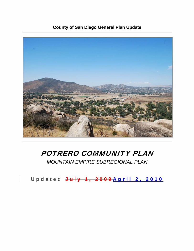
County of San Diego General Plan Update POTRERO COMMUNITY PLAN MOUNTAIN EMPIRE SUBREGIONAL PLAN Updated July 1, 2009 April 2, 2010
Transcript of MOUNTAIN EMPIRE SUBREGIONAL · PDF fileCounty of San Diego General Plan Update POTRERO ......
County of San Diego General Plan Update
POTRERO COMMUNITY PLAN MOUNTAIN EMPIRE SUBREGIONAL PLAN
U p d a t e d J u l y 1 , 2 0 0 9 A p r i l 2 , 2 0 1 0

M O U N T A I N E M P I R E S U B R E G I O N A L P L A N ( P O T R E R O ) S A N D I E G O C O U N T Y G E N E R A L P L A N PAGE 2
M O U N T A I N E M P I R E S U B R E G I O N A L P L A N ( P O T R E R O ) S A N D I E G O C O U N T Y G E N E R A L P L A N PAGE 3
TABLE OF CONTENTS POTRERO COMMUNITY PLAN
PAGE Introduction to the Community Plan ................................................................................ 1 Community Background .................................................................................................. 3
a. History............................................................................................................... 3 b. Relationship to Adjoining Communities............................................................. 4 c. Environmental Setting....................................................................................... 5 d. Existing Land Uses and Community Character................................................. 6 e. Existing Circulation and Mobility ....................................................................... 8 f. Existing Community Facilities and Infrastructure .............................................. 9 g. Public Safety ................................................................................................... 14 h. Trends and Future Projections........................................................................ 14
Community Vision ......................................................................................................... 16 Goals, Policies, & Implementation................................................................................. 17
1. Land Use......................................................................................................... 17 1.0 Rural Boundary ........................................................................................... 17 1.1 Regional Category....................................................................................... 17 1.2 Land Use Designations ............................................................................... 15 1.3 Village Boundary ......................................................................................... 20 1.4 Community Character ................................................................................. 16 1.5 Community Growth Policy ........................................................................... 19 1.6 Community Facilities ................................................................................... 20
1.7 Special Study Areas.................................................................................... 20 2. Circulation and Mobility ................................................................................... 23 2.1 Circulation Plan ........................................................................................... 30 2.2 Street Design............................................................................................... 23 2.3 Fire Access/Egress Routes ......................................................................... 31 2.4 Local Transit................................................................................................ 24 2.5 Trails ........................................................................................................... 32 2.6 Trip Reduction Strategies ............................................................................ 32 2.7 Parking ........................................................................................................ 33 2.8 Infrastructure and Utilities............................................................................ 33
3. Conservation and Open Space ....................................................................... 29 3.1 Resource Conservation and Management.................................................. 29 3.2 Parks and Recreation ................................................................................. 34 3.3 Dark Skies ................................................................................................... 36
4. Safety.............................................................................................................. 47 4.1 Hazards/Risk Avoidance and Mitigation ...................................................... 37 4.2 Emergency Preparedness and Response................................................... 37
5. Noise............................................................................................................... 38 5.1 Noise Standards and Mitigation ...................................................................... 38 Addendum ............................................................................................................... 39 Appendices Photographs
M O U N T A I N E M P I R E S U B R E G I O N A L P L A N ( P O T R E R O ) S A N D I E G O C O U N T Y G E N E R A L P L A N PAGE 4
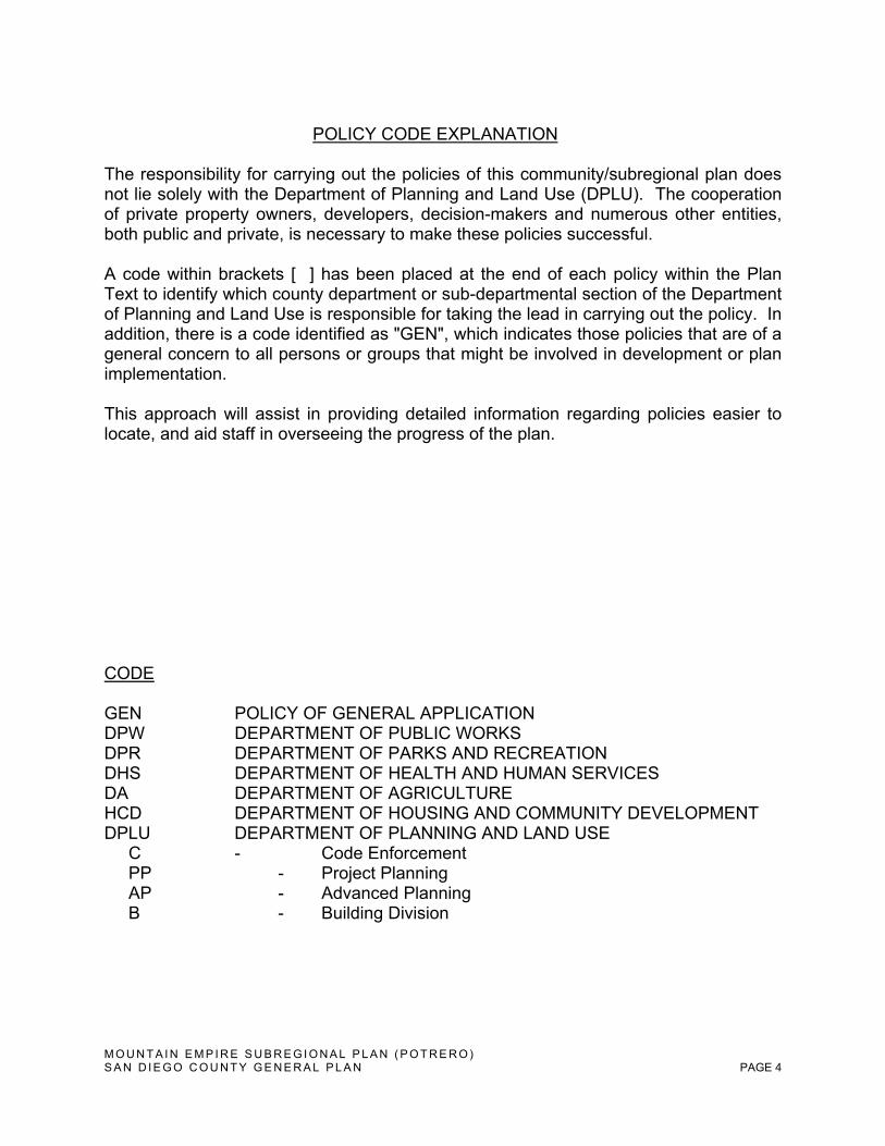
POLICY CODE EXPLANATION
The responsibility for carrying out the policies of this community/subregional plan does not lie solely with the Department of Planning and Land Use (DPLU). The cooperation of private property owners, developers, decision-makers and numerous other entities, both public and private, is necessary to make these policies successful. A code within brackets [ ] has been placed at the end of each policy within the Plan Text to identify which county department or sub-departmental section of the Department of Planning and Land Use is responsible for taking the lead in carrying out the policy. In addition, there is a code identified as "GEN", which indicates those policies that are of a general concern to all persons or groups that might be involved in development or plan implementation. This approach will assist in providing detailed information regarding policies easier to locate, and aid staff in overseeing the progress of the plan. CODE GEN POLICY OF GENERAL APPLICATION DPW DEPARTMENT OF PUBLIC WORKS DPR DEPARTMENT OF PARKS AND RECREATION DHS DEPARTMENT OF HEALTH AND HUMAN SERVICES DA DEPARTMENT OF AGRICULTURE HCD DEPARTMENT OF HOUSING AND COMMUNITY DEVELOPMENT DPLU DEPARTMENT OF PLANNING AND LAND USE C - Code Enforcement PP - Project Planning AP - Advanced Planning B - Building Division
M O U N T A I N E M P I R E S U B R E G I O N A L P L A N ( P O T R E R O ) S A N D I E G O C O U N T Y G E N E R A L P L A N PAGE 5
Introduction to the Community Plan
Purpose of the Community Plan Community Plans, though components of the San Diego County General Plan, are separate policy documents created to address the issues, characteristics, and visions of individual Communities. Each community has its own distinct physical setting with an accompanying unique history, culture, character, life style, and identify. Community Plans provide a framework for addressing localized issues and concerns that may be absent or not clearly focused within broader General Plan policies.
Used in conjunction with the General Plan, this Community Plan is a key tool for the public, the Community Planning Group, County staff, and decision-makers to advance policies that positively contribute to local character, conservation efforts, and pursuit of clear direction for the appropriate location, scale, and design of desired new buildings, land uses, and community facilities. Used in parallel with the General Plan, this Community Plan furthers the community’s vision into the future.
Scope of the Community Plan
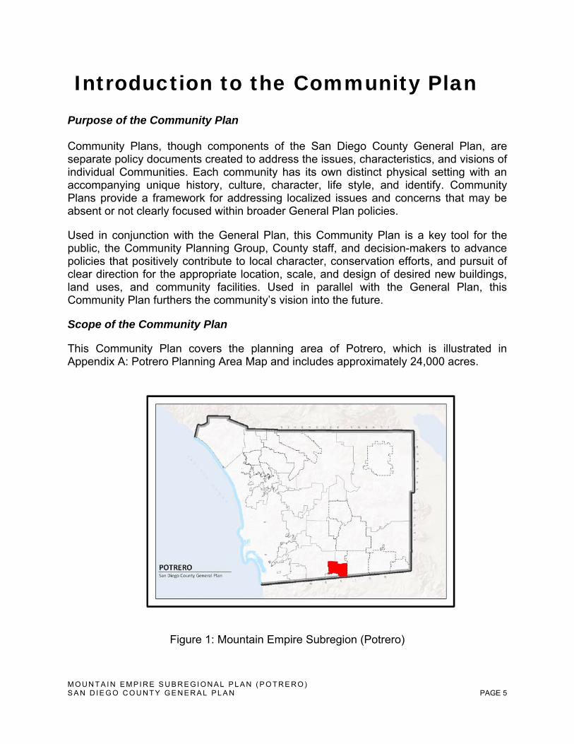
This Community Plan covers the planning area of Potrero, which is illustrated in Appendix A: Potrero Planning Area Map and includes approximately 24,000 acres.
Figure 1: Mountain Empire Subregion (Potrero)
M O U N T A I N E M P I R E S U B R E G I O N A L P L A N ( P O T R E R O ) S A N D I E G O C O U N T Y G E N E R A L P L A N PAGE 6
Public Involvement in Preparing the Community Plan
The County of San Diego General Plan Update has been underway for many years. However, as the update process nears completion, an invitation to concurrently update Community and Subregional Plans was extended. In response, the Potrero Planning Group embarked upon a series of weekly meetings to discuss the General Plan Update and its implications upon, for example, the existing Mountain Empire Subregional Plan. The Potrero Planning Group appointed a subcommittee on June 18, 2008 whose purpose was to draft a new Potrero Community Plan. The subcommittee conducted an informal survey, available at the Potrero Library, which gave the community an opportunity to anonymously express their opinions and priorities concerning planning and land use in the community of Potrero. The subcommittee’s work was vetted at publicly noticed Potrero Planning Group meetings at the Potrero Library on June 19, July 10, August 14, September 11, September 25, 2008 and October 28, 2008.
How to Use the Community Plan
To use this Plan, the General Plan should first be reviewed for goals and policies applicable to issue or topic under consideration. The General Plan Land Use Map should also be reviewed to determine the designated type, location and intensity of permissible development for any particular property or area. After reviewing the General Plan, this Community Plan should be reviewed for more detailed and “Potrero-specific” goals, policies and implementation programs.
Implementing, Monitoring, and Amending the Community Plan
It shall be the responsibility of the County to implement this Community Plan, to monitor progress towards its implementation, and to amend it; when necessary. For each policy or set of policies, there may be one or more implementation actions (or program) identified to carry it out. The implementation program also identifies the County department or agency responsible for its implementation. Many of the policies will be implemented by County ordinances and other discretionary actions including those particular to County Zoning Ordinance development standards.
The County staff and the Potrero Planning Group are stewards of the Potrero Community Plan. The Potrero Planning Group shall review the results of Potrero Community Plan implementation no less than once annually. The results of this review shall be provided in writing to County staff for inclusion in the annual General Plan Report to the State Office of Planning and Research. The annual review may be utilized as an opportunity to identify, in whole or part, necessary or desirable Community Plan amendments to respond to changes in the community’s vision, conditions or attitudes.
M O U N T A I N E M P I R E S U B R E G I O N A L P L A N ( P O T R E R O ) S A N D I E G O C O U N T Y G E N E R A L P L A N PAGE 7
Community Background
a. History
The Spanish word potrero means “pasturing place.” Until the middle of the 19th Century, the Potrero region was inhabited only by Kumeyaay Indians, who found the area rich in their main food, the acorn. The Kumeyaay Indians traveled a yearly circuit between Mexico, the San Diego coast, North County and the desert region. Artifacts indicate Potrero has been inhabited over one thousand years.
In 1868 Charles McAlmond, a ship captain from San Diego, settled in the Potrero Valley to restore his health and established a cattle ranch and farm. Others soon followed, becoming ranchers or woodcutters. The cordwood business flourished in this oak woodland, and large horse-drawn wagons hauled firewood and bark to San Diego.
Wagons no longer run between Potrero and San Diego, but much of the area might still seem like home to Captain McAlmond. Due in part to its location off of main thoroughfares and absence of public water and sewer, this quaint valley, surrounded by mountainous terrain, has suffered relatively little disturbance over the years. Our excellent air quality and unpolluted groundwater still attract those who seek health and wellness just as it did over 100 years ago.
While early settlers made a living by farming and ranching, some still do today. Current agricultural activities are of a modest, non-industrialized nature and include livestock (i.e., chickens, cattle, and horses), beekeeping, vineyards, and a Christmas tree farm. Those who don’t farm enjoy living a rural life removed from the noise, pollution and commotion of city life.
The community retains its rural character; a safe place to raise children, enjoy quiet evenings, dark skies, and the wide variety of wildlife that include bobcats, golden eagles, deer, coyote, rabbits and the occasional rattlesnake and mountain lion.
Today Potrero has a population of approximately 870 persons who reside in dispersed single-family homes. Residents find adequate services in two schools, a Kiwanis community center, a general store, a post office, a County Library branch, a volunteer fire station, a State Calfire station, a County regional park, one restaurant, and one tire shop; as well as the amenities available in nearby communities.
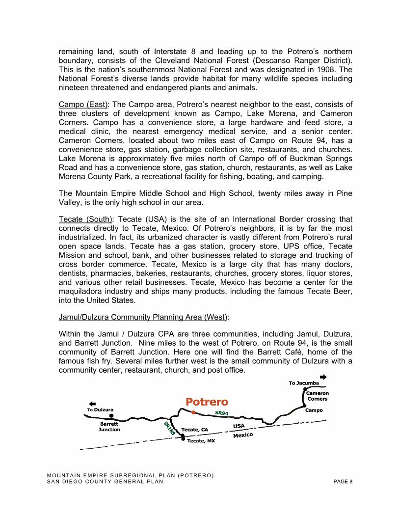
b. Relationship to Adjoining Communities
Mountain Empire Balance (North): The Mountain Empire Community abuts Potrero to the north. Mountain Empire has the only high school in the vicinity of Potrero. The
M O U N T A I N E M P I R E S U B R E G I O N A L P L A N ( P O T R E R O ) S A N D I E G O C O U N T Y G E N E R A L P L A N PAGE 8
remaining land, south of Interstate 8 and leading up to the Potrero’s northern boundary, consists of the Cleveland National Forest (Descanso Ranger District). This is the nation’s southernmost National Forest and was designated in 1908. The National Forest’s diverse lands provide habitat for many wildlife species including nineteen threatened and endangered plants and animals.
Campo (East): The Campo area, Potrero’s nearest neighbor to the east, consists of three clusters of development known as Campo, Lake Morena, and Cameron Corners. Campo has a convenience store, a large hardware and feed store, a medical clinic, the nearest emergency medical service, and a senior center. Cameron Corners, located about two miles east of Campo on Route 94, has a convenience store, gas station, garbage collection site, restaurants, and churches. Lake Morena is approximately five miles north of Campo off of Buckman Springs Road and has a convenience store, gas station, church, restaurants, as well as Lake Morena County Park, a recreational facility for fishing, boating, and camping.
The Mountain Empire Middle School and High School, twenty miles away in Pine Valley, is the only high school in our area.
Tecate (South): Tecate (USA) is the site of an International Border crossing that connects directly to Tecate, Mexico. Of Potrero’s neighbors, it is by far the most industrialized. In fact, its urbanized character is vastly different from Potrero’s rural open space lands. Tecate has a gas station, grocery store, UPS office, Tecate Mission and school, bank, and other businesses related to storage and trucking of cross border commerce. Tecate, Mexico is a large city that has many doctors, dentists, pharmacies, bakeries, restaurants, churches, grocery stores, liquor stores, and various other retail businesses. Tecate, Mexico has become a center for the maquiladora industry and ships many products, including the famous Tecate Beer, into the United States.
Jamul/Dulzura Community Planning Area (West):
Within the Jamul / Dulzura CPA are three communities, including Jamul, Dulzura, and Barrett Junction. Nine miles to the west of Potrero, on Route 94, is the small community of Barrett Junction. Here one will find the Barrett Café, home of the famous fish fry. Several miles further west is the small community of Dulzura with a community center, restaurant, church, and post office.
M O U N T A I N E M P I R E S U B R E G I O N A L P L A N ( P O T R E R O ) S A N D I E G O C O U N T Y G E N E R A L P L A N PAGE 9
c. Environmental Setting
Potrero (Zip Code 91963) lies within the Peninsular Ranges or the Southern California and/or Lower California Province; a group of mountain ranges that stretch approximately 900 miles from Southern California in the United States to the southern tip of Mexico’s Baja California Peninsula. Viewed west to east, Potrero is situated in a regional transition zone between the Pacific Ocean and Anza-Borrego Desert. (See Appendix B: Potrero Topographical Map) Potrero is located on Route 94, approximately 45 miles east of San Diego. Its closest urbanized neighbor is the community of Tecate, located only four miles to the southwest on State Route 188. Potrero is located in a broad valley of sparse development intermixed with grassy meadows, small-scale agricultural cultivation, and coast live oaks. Surrounding this quaint hamlet are rocky hillsides. The valley floor has an average elevation of 2,300 feet. Surrounding Potrero is Tecate Peak, also known as Mt. Kuchama, (elev. 3,881 feet), Potrero Peak (elev. 3,278 feet), Hartley Hill (elev. 3,169 feet), Hauser Mountain (elev. 3,808 feet) and Morena Butte (elev. 3,891 feet). These elevated locations provide a broad view of the valley. Potrero has an average summer high of 90 Fahrenheit and the average winter low is 34 Fahrenheit. It can receive occasional light snowfall in the winter. Precipitation now averages 15 inches or less annually due to the continuing drought that has already affected groundwater levels. If these conditions persist, drought conditions will become the norm.
Hot, dry winds named after the Santa Ana Canyon commonly occur between October and February. The Santa Ana winds are due to the pressure gradient between high pressure in the plateaus of the Great Basin and lower pressure over the Pacific Ocean. The average Santa Ana wind is approximately 25 to 40 mph and can get as strong as 80 to 100 mph.
Potrero is part of the Tijuana River Watershed, a bi-national basin that stretches across the U.S./Mexico border. The watershed covers 1,750 square miles from the Laguna Mountains in the U.S. to the Sierra de Juarez Mountains in the south. The major tributary for Potrero is Cottonwood Creek that begins southwest of Mount Laguna and flows south toward Mexico where it is joined by several tributaries. Some areas in the Potrero Valley have been identified by FEMA as being in the one hundred year floodplain for Potrero Creek.
The SANDAG 2007 Aggregated Vegetation map for the Potrero Planning Area indicates woodlands, meadow and marsh, grassland, sage scrub chaparral, chaparral, agricultural, developed/disturbed land and riparian scrub/woodland and forest designations. (See Appendix C: Potrero Aggregated Vegetation Map) Englemann oak, California interior oak, scrub oak and other varieties stretch along the grassy fields and meadows, many of which are home to raptors including the
M O U N T A I N E M P I R E S U B R E G I O N A L P L A N ( P O T R E R O ) S A N D I E G O C O U N T Y G E N E R A L P L A N PAGE 10
Golden Eagle, Peregrine Falcon and various owl species. Potrero's pristine, rural environment provides a home to multiple species of wildlife, many of which are classified as rare, threatened, or endangered. (See Appendix D: Potrero Rare, Threatened & Endangered Species List)
d. Existing Land Uses and Community Character
Existing Land Use
Potrero is one of San Diego’s few remaining rural communities with ample open-space and sparsely developed land. The approximately 24,000 acres of land that make up Potrero are divided into four land use categories by the San Diego Association of Government’s Existing Land Use (2007) Estimates. About 43% of the land use is “Vacant or Undeveloped Land”, followed by 40% ”Open Space Park or Preserve”. The remaining major categories are 11% “Spaced Rural Residential” and 4% of “Field Crops.” The final 2% of land in the Potrero Subregional Group Area is estimated as the “Road Right-of-way, Intensive Agriculture, Mobile Home Park, Elementary School, Fire/ Police Station and Other Retail Trade and Strip” Existing Land Use Categories.(See Appendix E: Potrero Existing Land Use Map) Route 94 Near the intersection of scenic Route 94 and Potrero Valley Road, one will find Potrero’s modest center of community activity. Here, the community’s General Store, U.S. Post Office, and local café offer a place where neighbors gather to share the latest local news or enjoy a good meal. Even with the busy highway traffic along Route 94, visits are casual and unhurried. Other civic gathering places include the Potrero Preschool, Elementary School and Continuation School, and Potrero Branch of the San Diego County Library. Along Route 94, there are a number of residential properties varying in size from four to forty acres. The developed areas in Potrero are shown in light green in the figure below. These areas are described in the subsequent paragraphs.

M O U N T A I N E M P I R E S U B R E G I O N A L P L A N ( P O T R E R O ) S A N D I E G O C O U N T Y G E N E R A L P L A N PAGE 11
Rural Residential Neighborhoods
Twin Lakes Residential Mobile Home Park
In the early 1960’s, the mobile home park was a weekend camping trailer site. With two small lakes stocked with fish, it was popular with tourists and locals alike. The two lakes are still full of fish and birds find sanctuary there. Over the years, residential trailers have become the norm and it has evolved into affordable housing for some limited income residents and seniors. The trailer park has a swimming pool and laundry.
Potrero Circle
Many of these parcels are smaller than the “Multiple Rural” residential, 1du/4, 8, 20 acres that describes their land use. These residential parcels were grandfathered in. The Kiwanis/Potrero Community Center is on Potrero Valley Road. It is a good-sized building, with a kitchen and bathroom. This community building is available for community functions and reserved through the Kiwanis.
Harris Ranch Road
At its eastern end, Potrero Valley Road becomes a privately maintained road that intersects with Harris Ranch Road. The road is full of potholes and poorly maintained, but proper maintenance could enhance public safety by providing a second access/egress back to SR 94, which is needed for evacuation purposes. The Harris Fire, in October of 2007 started in this area. Parcels are larger “Multiple Rural”, 1du/4, 8, 20 acres. Several historic sites are located near here.
M O U N T A I N E M P I R E S U B R E G I O N A L P L A N ( P O T R E R O ) S A N D I E G O C O U N T Y G E N E R A L P L A N PAGE 12
Coyote Holler Road/Hartley Hill
In the 1970’s, a large area off of Round Potrero Road was cleared and subdivided. This development increased the population of Potrero more than any other time in its history. In 1977, more homes were built on Hartley Hill, on the west side of Round Potrero Road. Orchards, small farms, and livestock are found there. This area is considered “Multiple Rural”, 1du/4, 8, 20 acres.
Horizon View
Horizon View is aptly named for its outstanding sunsets. This area is secluded and less populated. During the Harris Fire, the Horizon View area experienced some of the heaviest fire damage.
Community Character
Potrero is one of the few unspoiled open-space communities left in the unincorporated area of San Diego County.
Potrero Creek crosses the gently sloping valley floor. Oak trees dot the fields of native grass and springtime wildflowers bloom as far as the eye can see. The spirit of Mt. Kuchama (Tecate Peak) and the majesty of Morena Butte are timeless.
The phrase “community character” suggests much more than visual images. Our community has a strong commitment to preserve our rural character and traditional values of family, community, independence, responsibility, self-government, conservation, entrepreneurship, and a strong work ethic in a fast-changing world.
We are tied to our natural resources and know their limitations. We value the unique landforms, abundant wild life, native vegetation, hiking trails, fresh air, unpolluted groundwater, horses, cattle, and newly planted fields.
We choose to live here because of the tranquility and privacy provided by the large, open spaces, the ability to know our neighbors without being city-close and to have unobstructed views of the mountains, the sky and stars.
e. Existing Circulation and Mobility
Access to the community of Potrero from San Diego is by way of the two-lane (east and west) Route 94. Both Harris Ranch Road and Potrero Valley Road extend from Route 94 and provide the only two access points into the Potrero community. Potrero Valley Road also intersects with Potrero Park Drive, Round Potrero Road and Potrero Circle. Potrero Valley Road is currently the only route into and out of Potrero’s valley floor.
After evaluating evacuation alternatives in the wake of the 2007 Harris fire, the Potrero Planning Group became concerned that there was not a second, passable
M O U N T A I N E M P I R E S U B R E G I O N A L P L A N ( P O T R E R O ) S A N D I E G O C O U N T Y G E N E R A L P L A N PAGE 13
access/egress leading out of Potrero. We would like to see the connection between Potrero Valley Road and Harris Ranch Road, now a private road, come under County maintenance to ensure its availability in times of emergency.
Local transit is provided by the San Diego Metropolitan Transit System’s (MTS) Rural Bus System, which makes three daily trips to bus stops at the Potrero Library, General Store, and U.S. Post Office. Passage for pedestrians along local roads is generally limited due to narrow shoulders. Potrero’s rural character is enhanced by a lack of public sidewalks, street lighting, curbs, and gutters.
f. Existing Community Facilities and Infrastructure
The Community of Potrero has no public water or sewer service. It is completely dependent upon groundwater for potable water and septic systems for waste disposal. Consistent with its rural locale, Potrero has a small number of important civic facilities, including:
1. U.S. Post Office (25050 Route 94)
2. Calfire Station (formerly CDF) (25130 Route 94)
3. Volunteer Fire Station
4. San Diego County Library – Potrero Branch (24883 Potrero Valley Road)
5. Potrero Elementary School (24875 Potrero Valley Road)
6. Potrero Regional Park (terminus of Park Potrero Road)
7. Kiwanis/Community Center (25767 Potrero Valley Road)
The Potrero County Park, over 200 acres in size, offers recreational opportunities for day use visitors or recreational vehicle, tent, and group campers. Grassy meadows, rocky hillsides, and a grove of oak trees provide a quiet oasis for hikers, campers, and picnickers. The park is the site of a Renaissance battle reenactment every spring. It also has ball fields, a dance pavilion, playgrounds, and hiking trails. Potrero marks its Fourth of July celebration with a fair at the park that includes a horseshoe tournament.
The Potrero Branch of the San Diego County Library has a community room often used for classes and community meetings. The Kiwanis/Community Center includes a sizeable building, with an open room, kitchen, bathroom, and a disabled access ramp. This community building is available for functions and reserved through the Kiwanis.
Besides the existing facilities and infrastructure located in Potrero, residents are fortunate to have Tecate, USA; Tecate, Mexico; and Campo as neighbors. These
M O U N T A I N E M P I R E S U B R E G I O N A L P L A N ( P O T R E R O ) S A N D I E G O C O U N T Y G E N E R A L P L A N PAGE 14
three nearby communities have services that Potrero definitely takes advantage of, making it impractical and unnecessary to duplicate these services in our community.
g. Public Safety
Potrero is particularly susceptible to three natural disaster types: wildfire, floods, and earthquakes. Along with an abundance of very dry vegetation, strong Santa Ana winds have driven wildfires into Potrero resulting in tragic losses of life and property. In fact, the 2007 Harris Fire highlighted the absence of a second, passable access/egress route leading out of Potrero. A portion of Potrero’s valley floor is located within a floodplain. Though not located on or within an earthquake fault, seismic activity is endemic to Potrero as with much of Southern California.
Public safety providers in Potrero currently include:
1. San Diego County Sheriff’s Department – Consistent with rural locations, response times can vary depending on where the on-call deputy is when a call is received. The station is located nine miles away in Campo.
2. California Department of Forestry and Fire Protection (CalFire) - A station is located in Potrero – response times vary from about five to 20 minutes depending on the location of the fire.
3. Potrero Volunteer Fire Department (Rural Fire) – The station is located in Potrero but it is not always manned 24 hours. Response time varies.
4. Ambulance/Paramedics – The nearest ambulance is located 11 miles away in Cameron Corners. Response time varies between 20 to 45 minutes.
The Community Emergency Response Team (CERT) has a chapter in Potrero that utilizes the Volunteer Fire Station for training.
h. Trends and Future Projections
Historically, Potrero has been sparsely populated. Because of its relatively remote rural location and limited groundwater resource, the carrying capacity of Potrero has been limited and it will continue to be limited due to our natural environmental resources and community character. In 2008, Potrero’s population was approximately 870 people; in 2002, our population was 684. This is equivalent to a growth rate of approximately 4% per year. This growth rate is largely attributed to the increase of trailers in Twin Lakes Residential Mobile Park and is not reflective of the community as a whole.
Currently Potrero’s work force is divided between those who commute, local workers, and home-based businesses. The increasing development of Tecate,
M O U N T A I N E M P I R E S U B R E G I O N A L P L A N ( P O T R E R O ) S A N D I E G O C O U N T Y G E N E R A L P L A N PAGE 15
U.S.A. and Campo will create more job opportunities for locals. Potrero also makes the most of the facilities and infrastructure of these two communities. This works toward one of the County General Plan’s Guiding Principles to reinforce the vitality and local economy of existing communities.
Although Southern California has experienced severe drought before, this time could be different. Climate change, some argue, means that the lack of rainfall and the elevated temperatures will become the norm. Drought impacts increase with the length of a drought, as carry-over supplies in reservoirs are depleted and water levels in groundwater basins decline.
In addition, drought conditions have created a situation of extreme fire danger; climate change will lead to dramatic increases in both the annual area burned by California wildfires and the number of potentially catastrophic fires – doubling these losses in some regions.
Potrero’s agricultural heritage of small rural farms combined with alternative agricultural techniques, like drip irrigation, organic farming, and hydroponics will help to offset drought. County policies that encourage environmentally friendly, sustainable land use would benefit Potrero.
Thinking green, preserving our open space and wildlife habitat is becoming even more important. The sustainability of Potrero's environmental resources, biological qualities, and diversity, are all factors that preserve Potrero's quality of life.
M O U N T A I N E M P I R E S U B R E G I O N A L P L A N ( P O T R E R O ) S A N D I E G O C O U N T Y G E N E R A L P L A N PAGE 16
Community Vision
Potrero and its residents support traditional values of family, community, independence, responsibility, self-government, conservation, entrepreneurship, and a strong work ethic. They are tied to the area’s fragile natural resources and highly value its unique landforms, abundant wildlife, native vegetation, hiking trails, fresh air, night skies, unpolluted groundwater, horses, cattle, and planted fields. They have chosen a life of tranquility and privacy provided by the large, open spaces, the ability to know their neighbors and to have unobstructed views to and from the mountains, the blue sky and star-filled nights.
Countywide, new development should be sited within already urbanized areas including, for example, those within the County Water Authority boundary. If undeveloped land is to be used, then the burden for exceptional design, demonstrable longevity, and environmental sensitivity shall be most stringently emphasized. Preservation of Potrero’s agricultural and natural lands will continue to take priority over urbanized land uses in order to provide a local food source; maintain watershed vitality; sustain a clean and ready water supply; preserve clean air; allow access to local natural resources; conserve natural habitat, and maintain regional biodiversity.
The primary objective of the design of new buildings and the adaptive reuse of older ones is to create a culture of permanence with well-crafted, sound, inspired, and beloved structures of enduring quality. Places shall promote longevity and the stewardship of both our natural and man-made environments. Individual buildings and their groupings shall both conserve and produce renewable energy wherever possible to promote economies of scale and to reduce reliance on costly fossil fuels and inefficient distribution systems.
In the future we plan to demonstrate our environmental and social responsibility through a community commitment to self-sustainability.
We intend to preserve, protect and enhance our unique community character, rural atmosphere, natural resources, wildlife, and open space. We will strive to minimize the impact of future development and remain environmentally friendly with extremely low density.
We will foster a viable, pristine Potrero and remain appreciative of something that cannot be replaced.
M O U N T A I N E M P I R E S U B R E G I O N A L P L A N ( P O T R E R O ) S A N D I E G O C O U N T Y G E N E R A L P L A N PAGE 17
Goals, Policies, & Implementation
1. Land Use Land Use Diagram
The Potrero Community Plan Area Land Use Map is provided in the General Plan appendix as figure LU-A-12.4.
Rural Boundary
The Community of Potrero shall have a boundary coterminous with that depicted as the Potrero Land Use Map (figure LU-A-12.4) in the County of San Diego General Plan).
The Potrero Rural Village Boundary is contained in Figure 2
Regional Category
The Community of Potrero shall be considered Rural and Semi-Rural Lands according to the General Plan’s Community Development Model: Regional Categories.
1.1. Land Use Designations
Issue LU 1.1 – A consistent land use regulatory framework is necessary to provide vertical consistency between the San Diego County General Plan and Potrero Community Plan. It is necessary and desirable to apply General Plan Land Use designations appropriate to Potrero’s unique rural character attributes.
Goal LU 1.1 – The preservation of Potrero’s rural atmosphere through restricting development on land constrained by physical and environmental hazards, along with the protection of limited open space, natural resources, open space buffers, and agricultural opportunities.
Policy LU 1.1.1 – Prohibit, for agricultural land preservation purposes, the reduction of minimum lot sizes provided for by the General Plan and Community Plan when such reductions would result in other new parcels or remainder parcels conducive to urban development.
Policy LU1.1.2 – For all private projects concerning property within the Potrero Community Plan boundary, the Board of Supervisors shall not take action on a Plan Amendment Applications (PAA) (requests to initiate a General Plan amendment); or (2) General Plan Amendments until in receipt of a recommendation from the Potrero Planning Group.
M O U N T A I N E M P I R E S U B R E G I O N A L P L A N ( P O T R E R O ) S A N D I E G O C O U N T Y G E N E R A L P L A N PAGE 18
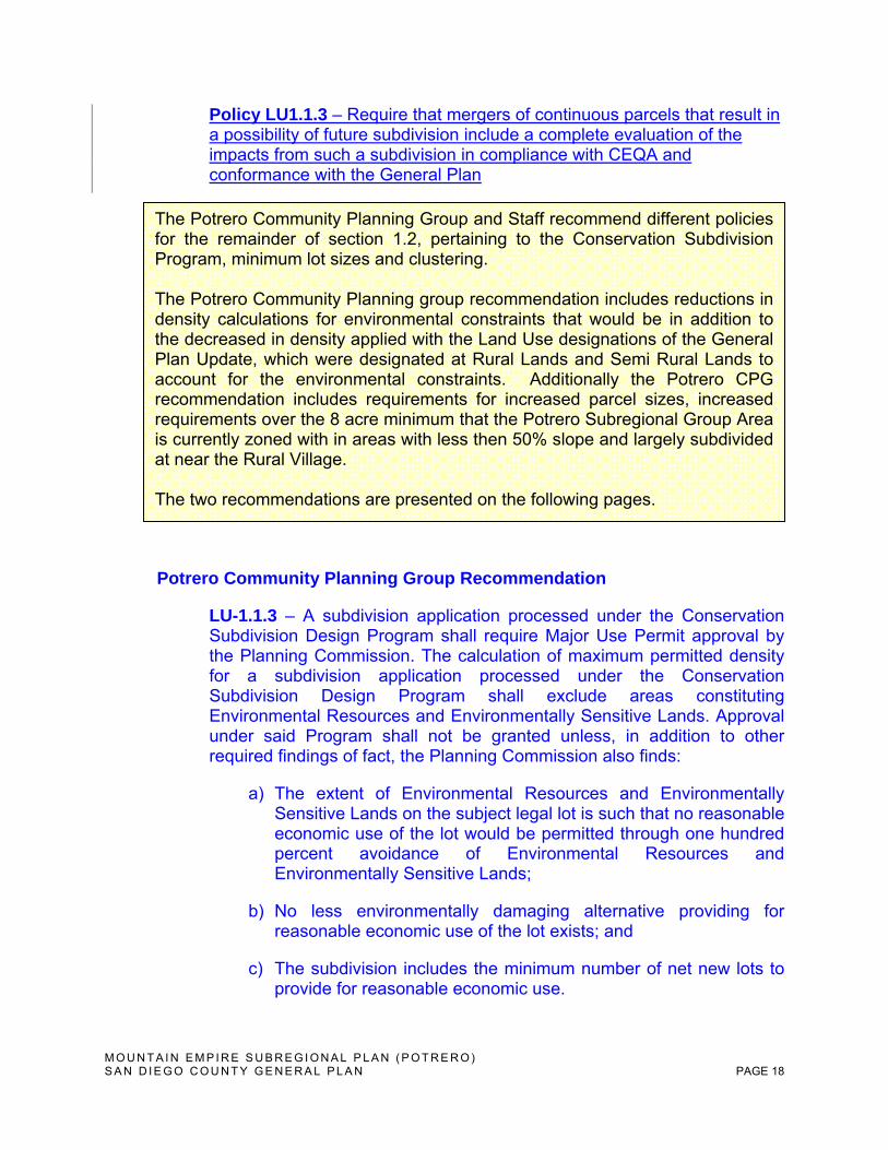
Policy LU1.1.3 – Require that mergers of continuous parcels that result in a possibility of future subdivision include a complete evaluation of the impacts from such a subdivision in compliance with CEQA and conformance with the General Plan
Potrero Community Planning Group Recommendation
LU-1.1.3 – A subdivision application processed under the Conservation Subdivision Design Program shall require Major Use Permit approval by the Planning Commission. The calculation of maximum permitted density for a subdivision application processed under the Conservation Subdivision Design Program shall exclude areas constituting Environmental Resources and Environmentally Sensitive Lands. Approval under said Program shall not be granted unless, in addition to other required findings of fact, the Planning Commission also finds:
a) The extent of Environmental Resources and Environmentally Sensitive Lands on the subject legal lot is such that no reasonable economic use of the lot would be permitted through one hundred percent avoidance of Environmental Resources and Environmentally Sensitive Lands;
b) No less environmentally damaging alternative providing for reasonable economic use of the lot exists; and
c) The subdivision includes the minimum number of net new lots to provide for reasonable economic use.
The Potrero Community Planning Group and Staff recommend different policies for the remainder of section 1.2, pertaining to the Conservation Subdivision Program, minimum lot sizes and clustering. The Potrero Community Planning group recommendation includes reductions in density calculations for environmental constraints that would be in addition to the decreased in density applied with the Land Use designations of the General Plan Update, which were designated at Rural Lands and Semi Rural Lands to account for the environmental constraints. Additionally the Potrero CPG recommendation includes requirements for increased parcel sizes, increased requirements over the 8 acre minimum that the Potrero Subregional Group Area is currently zoned with in areas with less then 50% slope and largely subdivided at near the Rural Village. The two recommendations are presented on the following pages.
M O U N T A I N E M P I R E S U B R E G I O N A L P L A N ( P O T R E R O ) S A N D I E G O C O U N T Y G E N E R A L P L A N PAGE 19
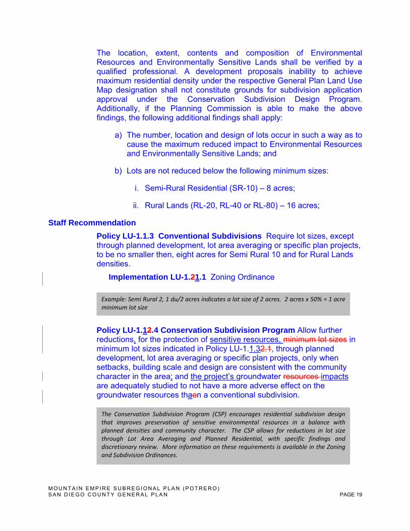
The location, extent, contents and composition of Environmental Resources and Environmentally Sensitive Lands shall be verified by a qualified professional. A development proposals inability to achieve maximum residential density under the respective General Plan Land Use Map designation shall not constitute grounds for subdivision application approval under the Conservation Subdivision Design Program. Additionally, if the Planning Commission is able to make the above findings, the following additional findings shall apply:
a) The number, location and design of lots occur in such a way as to cause the maximum reduced impact to Environmental Resources and Environmentally Sensitive Lands; and
b) Lots are not reduced below the following minimum sizes:
i. Semi-Rural Residential (SR-10) – 8 acres;
ii. Rural Lands (RL-20, RL-40 or RL-80) – 16 acres;
Staff Recommendation
Policy LU-1.1.3 Conventional Subdivisions Require lot sizes, except through planned development, lot area averaging or specific plan projects, to be no smaller then, eight acres for Semi Rural 10 and for Rural Lands densities.
Implementation LU-1.21.1 Zoning Ordinance
Policy LU-1.12.4 Conservation Subdivision Program Allow further reductions, for the protection of sensitive resources, minimum lot sizes in minimum lot sizes indicated in Policy LU-1.1.32.1, through planned development, lot area averaging or specific plan projects, only when setbacks, building scale and design are consistent with the community character in the area; and the project’s groundwater resources impacts are adequately studied to not have a more adverse effect on the groundwater resources thaen a conventional subdivision.
Example: Semi Rural 2, 1 du/2 acres indicates a lot size of 2 acres. 2 acres x 50% = 1 acre minimum lot size
The Conservation Subdivision Program (CSP) encourages residential subdivision design that improves preservation of sensitive environmental resources in a balance with planned densities and community character. The CSP allows for reductions in lot size through Lot Area Averaging and Planned Residential, with specific findings and discretionary review. More information on these requirements is available in the Zoning and Subdivision Ordinances.
M O U N T A I N E M P I R E S U B R E G I O N A L P L A N ( P O T R E R O ) S A N D I E G O C O U N T Y G E N E R A L P L A N PAGE 20
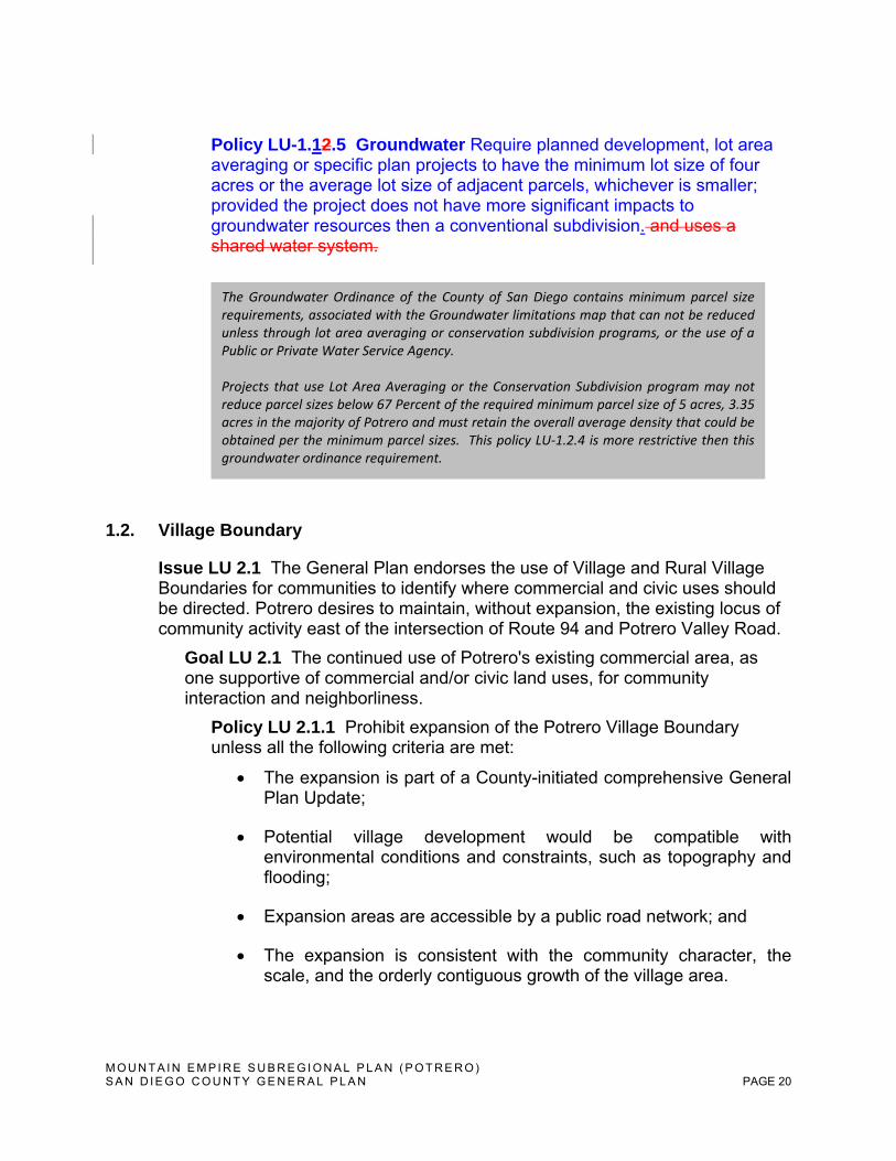
Policy LU-1.12.5 Groundwater Require planned development, lot area averaging or specific plan projects to have the minimum lot size of four acres or the average lot size of adjacent parcels, whichever is smaller; provided the project does not have more significant impacts to groundwater resources then a conventional subdivision. and uses a shared water system.
1.2. Village Boundary
Issue LU 2.1 The General Plan endorses the use of Village and Rural Village Boundaries for communities to identify where commercial and civic uses should be directed. Potrero desires to maintain, without expansion, the existing locus of community activity east of the intersection of Route 94 and Potrero Valley Road.
Goal LU 2.1 The continued use of Potrero's existing commercial area, as one supportive of commercial and/or civic land uses, for community interaction and neighborliness.
Policy LU 2.1.1 Prohibit expansion of the Potrero Village Boundary unless all the following criteria are met:
The expansion is part of a County-initiated comprehensive General Plan Update;
Potential village development would be compatible with environmental conditions and constraints, such as topography and flooding;
Expansion areas are accessible by a public road network; and
The expansion is consistent with the community character, the scale, and the orderly contiguous growth of the village area.
The Groundwater Ordinance of the County of San Diego contains minimum parcel size requirements, associated with the Groundwater limitations map that can not be reduced unless through lot area averaging or conservation subdivision programs, or the use of a Public or Private Water Service Agency. Projects that use Lot Area Averaging or the Conservation Subdivision program may not reduce parcel sizes below 67 Percent of the required minimum parcel size of 5 acres, 3.35 acres in the majority of Potrero and must retain the overall average density that could be obtained per the minimum parcel sizes. This policy LU‐1.2.4 is more restrictive then this groundwater ordinance requirement.
M O U N T A I N E M P I R E S U B R E G I O N A L P L A N ( P O T R E R O ) S A N D I E G O C O U N T Y G E N E R A L P L A N PAGE 21
Before acting on a request to expand the Potrero Village Boundary, the Board of Supervisors shall receive and consider a recommendation from the Potrero Planning Group.
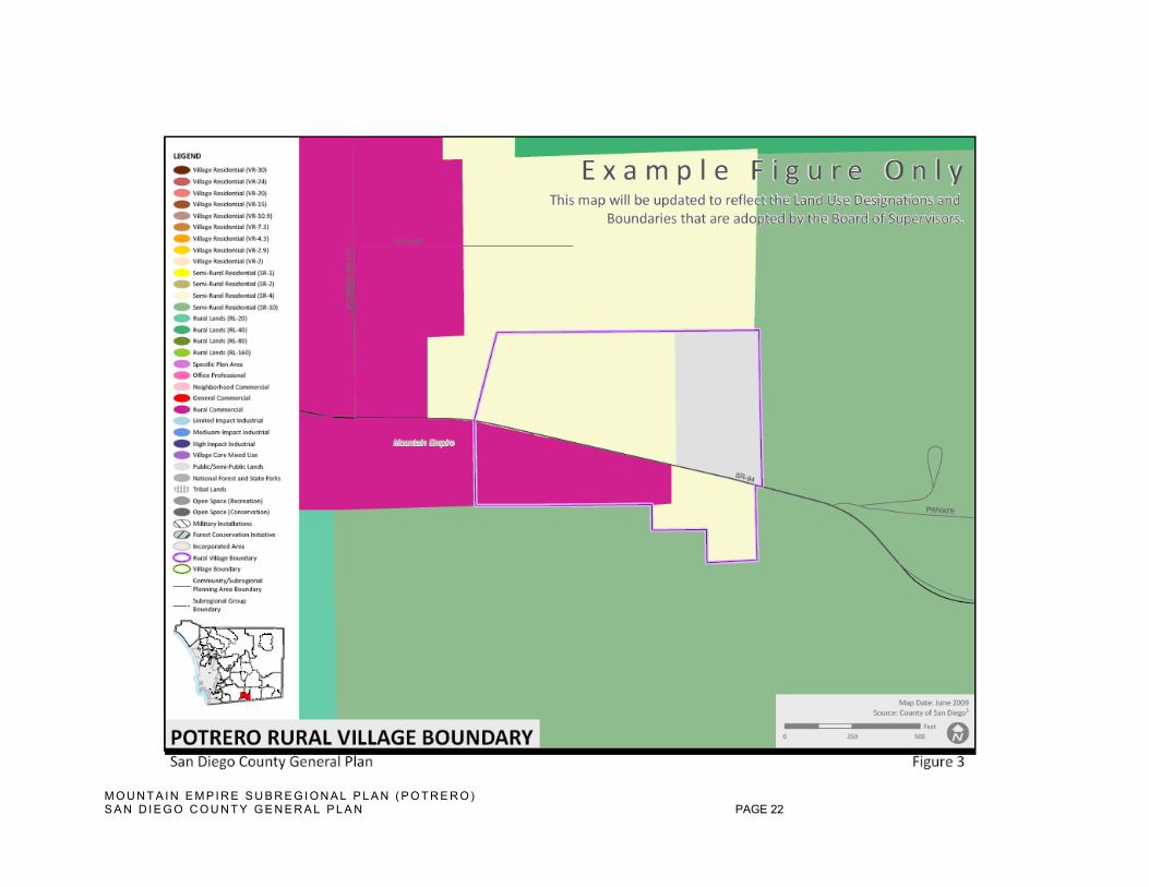
M O U N T A I N E M P I R E S U B R E G I O N A L P L A N ( P O T R E R O ) S A N D I E G O C O U N T Y G E N E R A L P L A N PAGE 22

M O U N T A I N E M P I R E S U B R E G I O N A L P L A N ( P O T R E R O ) S A N D I E G O C O U N T Y G E N E R A L P L A N PAGE 23
This page intentionally left blank
M O U N T A I N E M P I R E S U B R E G I O N A L P L A N ( P O T R E R O ) S A N D I E G O C O U N T Y G E N E R A L P L A N PAGE 24
1.3. Community Character
Issue LU 3.1 Potrero’s rural character is treasured by its residents, and preservation of this character is a fundamental tenet of this Community Plan. The components of development must be evaluated to ensure their design retains Potrero’s community character. These components are addressed below.
Site Design
Goal LU 3.1 Retention of Potrero’s rural, agriculture-based economy and the prevention of widespread urban development and sprawl.
Policy LU 3.1.1 Ensure new subdivisions or parcel line adjustments including dimensions and configurations that preserve natural features such as ridges, wetlands, streams, or agricultural lands.
Policy LU 3.1.2 Ensure new subdivisions, whether accompanied by proposed building construction or not, should depict building envelopes to ensure, for example, compatibility with Potrero’s character and natural resources.
Commercial Development
Goal LU 3.2 An intensity of commercial land use targeted only to the provision of services that are essential to Potrero’s residents and its occasional visitors.
Policy LU 3.2.1 Strongly discourage strip commercial development and large monolithic and repetitive buildings. Require commercial development project design composed of multiple structures with the appearance of distinct independent buildings.
Policy LU 3.2.2 Prohibit large-format retail uses, typically referred to as “big box stores” since their scale and associated traffic is inconsistent with Potrero’s rural character.
Policy LU 3.2.3 Prohibit new commercial development or redevelopment that exceeds two stories or twenty-four feet in height, as measured to the eave.
Policy LU 3.2.4 Prohibit new commercial development or redevelopment that exceeds 0.10 Floor Area Ratio (FAR).
Policy LU 3.2.5 Require commercial development exceeding 2,500 square feet to retain rural character by having multiple buildings that vary in scale and design.
M O U N T A I N E M P I R E S U B R E G I O N A L P L A N ( P O T R E R O ) S A N D I E G O C O U N T Y G E N E R A L P L A N PAGE 25
Building Design
Goal LU 3.3 Preserve Potrero’s dispersed development pattern with low-scale buildings, ample setbacks, and complimentary landscaping.
Policy LU 3.3.1 Require structures to be compatible with neighboring structures with respect to mass, scale and bulk.
Policy LU 3.3.2 Require building surfaces over 50 feet in length to be relieved with changes of plane or architectural treatment that provide a strong vertical shadow line and visual interest.
Policy LU 3.3.3 Require residential structures on slopes to be generally oriented such that their greatest horizontal axis or axes are parallel to the predominant natural contours of the site.
Policy LU 3.3.4 Require exterior colors and materials of residential structures to be earth tones or other colors harmonious with the site and vicinity.
Roads, Parking, Site Design Features, and Landscaping
Goal LU 3.4 To carefully integrate new development or redevelopment with the natural landscape, thereby preventing incongruent building forms and densities and minimizing visual impacts to scenic resources.
Policy LU 3.4.1 Discourage solid fences or walls greater than three feet in height separating properties or facing private or public roads. Where necessary to facilitate compatibility between land uses, they should be:
Minimized in length;
Provided with a change of plane at a minimum of 50 feet intervals;
Provided with earth berms or landscape materials; and/or
Utilize non-flammable materials such as stone or metal.
Policy LU.3.4.2 Provide fences or walls only at those portions of large properties where necessary for privacy or security.
Policy LU 3.4.3 Encourage planting shrubs and trees along fences or walls.
Policy LU 3.4.4 Promote native stone, wrought iron, wood, and brick materials for fences and walls.
Policy LU 3.4.5 Prohibit the use of corrugated metal, brightly colored plastic materials, reed materials and concrete block materials for walls and fences, whenever feasible.
M O U N T A I N E M P I R E S U B R E G I O N A L P L A N ( P O T R E R O ) S A N D I E G O C O U N T Y G E N E R A L P L A N PAGE 26
Policy LU 3.4.6 Require roads and driveways to follow slope contours unless such design would result in significantly greater grading or visual impact.
Policy LU 3.4.7 Require parking and service areas for commercial uses to be located to minimize public view from adjacent roads.
Policy LU 3.4.8 Require landscaping provided in accordance with Conservation and Open Space policy COS-4.2 and Safety Element policy S-3.3, while encouraging an informal placement with a meandering layout.
Policy LU 3.4.9 Grading and vegetation removal shall be strictly limited to building pads, access roads, and necessary fuel breaks.
Policy LU 3.4.10 Every effort should be taken to retain the maximum number of significant trees on a property, consistent with fire safety standards. Significant trees are defined as trees measuring more than ten inches in diameter, or with a total diameter of any two trunks of at least 16 inches, as measured four feet about the root crown.
Policy LU 3.4.11– Require sign design to communicate in a simple, clear and uncluttered manner that is in character with the neighborhood and the buildings and uses represented.
Policy LU 3.4.12 Minimize the size of all signs with a height not to exceed the highest portion of the building. Require the height of all monument signs to be as low to the ground as possible.
Policy LU 3.4.13 Prohibit the following types of signs: internally illuminated signs, back-lit signs which appear to be internally illuminated, signs that flash, blink, revolve, are in-motion or give the illusion of motion, portable or mobile signs, off-premise signs, and pole-mounted signs.
1.4 Community Growth Policy Issue LU 4.1 The aesthetic quality and biological communities in and around Potrero benefit from publicly owned open space lands; both interspersed within and surrounding the community. The Community of Tecate (USA) includes higher intensity commercial and industrial land uses. These are inconsistent with the character of Potrero.
Goal LU 4.1 A land use plan that maximizes open space lands, regardless if transferred to private ownership at a future date for purposes of conservation.
Policy LU 4.1.1 Promote the expansion of publicly-owned open space land in Potrero that is maintained in perpetuity.
Goal LU 4.2 Rural, very low density, and open space Land Use Designations separating the Tecate and Potrero communities that provide a buffer between disparate land use and development intensities of these communities.
M O U N T A I N E M P I R E S U B R E G I O N A L P L A N ( P O T R E R O ) S A N D I E G O C O U N T Y G E N E R A L P L A N PAGE 27
Policy LU 4.2.1 Maintain Land Use Designations of Rural Lands, Public/Semi-Public Facilities, Open Space (Recreation) or Open Space (Conservation) to provide a distinct separation between the Tecate and Potrero communities.
Policy LU 4.2.2 Conversion of Public Lands to Private Ownership. Assign lands in public use an underlying designation of Rural Lands 160. When such lands are transferred to private ownership, the RL-160 designation shall apply until the appropriate long-term use of the property is determined and a general plan amendment is approved for redesignation of the property. This policy applies to areas on the Land Use Map designated Public/Semi-Public Facilities, Federal and State Lands, and Tribal Lands. (adapted from LU-1.8 in the Draft General Plan)
1.5 Community Facilities
Issue LU 5.1 Residents of Potrero engage in agricultural practices but lack a focal point to facilitate community education and the sharing of ideas of, for example, organic cultivation or integrated pest management.
Goal LU 5.1 The establishment of a “Potrero Community Garden” that provides a forum for community education on agricultural issues and also area(s) for communal growing and harvesting.
Policy LU 5.1.1 Facilitate a community dialogue to locate and install a publicly- or privately-owned community garden that is operated and maintained by a separate, independent “gardening organization.”
1.6 Special Study Areas
Issue LU 6.1 While the Potrero Community Plan provides a policy document to positively evolve the community over time, implementing regulations are necessary to accurately carry-out the intent of each policy or group of policies. Subsequent to the County General Plan Update, work will begin on preparing an Implementation Plan for the Potrero Community Plan.
Goal LU 6.1 New and/or revised implementation measures to address the goals and policies of the Community Plan.
Policy LU 6.1.1 Coordinate the preparation of the Potrero Community Plan Implementation Plan with the Potrero Planning Group.
Issue LU 6.2 Large land holdings situated on level terrain may invite large-scale development proposals potentially inconsistent with Potrero’s rural character.
Goal LU 6.2 Establish a comprehensive plan for the agricultural valley located at the northern terminus of Round Potrero Road.
Policy LU 6.2.1 In addition to the General Plan Amendment review requirements of this Community Plan, a Specific Plan shall be required prior to development of the Special Study Area, identified in the map
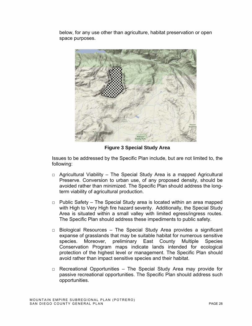
M O U N T A I N E M P I R E S U B R E G I O N A L P L A N ( P O T R E R O ) S A N D I E G O C O U N T Y G E N E R A L P L A N PAGE 28
below, for any use other than agriculture, habitat preservation or open space purposes.
Figure 3 Special Study Area
Issues to be addressed by the Specific Plan include, but are not limited to, the following:
□ Agricultural Viability – The Special Study Area is a mapped Agricultural Preserve. Conversion to urban use, of any proposed density, should be avoided rather than minimized. The Specific Plan should address the long-term viability of agricultural production.
□ Public Safety – The Special Study area is located within an area mapped with High to Very High fire hazard severity. Additionally, the Special Study Area is situated within a small valley with limited egress/ingress routes. The Specific Plan should address these impediments to public safety.
□ Biological Resources – The Special Study Area provides a significant expanse of grasslands that may be suitable habitat for numerous sensitive species. Moreover, preliminary East County Multiple Species Conservation Program maps indicate lands intended for ecological protection of the highest level or management. The Specific Plan should avoid rather than impact sensitive species and their habitat.
□ Recreational Opportunities – The Special Study Area may provide for passive recreational opportunities. The Specific Plan should address such opportunities.
M O U N T A I N E M P I R E S U B R E G I O N A L P L A N ( P O T R E R O ) S A N D I E G O C O U N T Y G E N E R A L P L A N PAGE 29
□ Geologic Conditions – The entire Special Study Area is a mapped liquefaction hazard area. The Specific Plan should address this hazard to public safety.
□ Groundwater Quality & Quantity – Like all of the Community Plan area, the Special Study Area is dependent upon groundwater. The Specific Plan should, consistent with existing County requirements such as the Groundwater Ordinance, address this natural limitation to development.
□ Wastewater Disposal - Like all of the Community Plan area, the Special Study Area is devoid of municipal wastewater treatment facilities. The Specific Plan should, consistent with existing County requirements such as the Groundwater Ordinance, address this natural limitation to development.
M O U N T A I N E M P I R E S U B R E G I O N A L P L A N ( P O T R E R O ) S A N D I E G O C O U N T Y G E N E R A L P L A N PAGE 30
2. Circulation and Mobility
2.1 Circulation Plan and Road Design
Issue CM 1.1 Potrero relies upon a limited network of public roads to obtain vehicular access throughout the community. The continued sparse use of paved roads, whether publicly or privately owned, is desirable as it facilitates the preservation of Potrero’s rural character. Public and private roadways provide an important contribution to Potrero’s rural character through their reduced pavement widths, absence of overhead lighting or utilities and use of natural drainage management.
Goal CM 1.1 A circulation system of public roads, which provides for uncongested travel, along with safe routes for bicyclists and pedestrians, retaining Potrero’s rural character by omitting streetlights, curbs, gutters and paved sidewalks.
Policy CM 1.1.1 Expand the road system, whether publicly or privately owned, only when it improves public safety or accompanies new development that is, on the whole, consistent with General Plan and Community Plan policies.
Policy CM 1.1.2 Designate and retain the existing public roads on the Circulation Element Roadways diagram, as follows:
1. Potrero Valley Road as a Minor Collector (2.3C) between Route 94 and Potrero Park Drive.
2. Potrero Valley Road as a Light Collector (2.2E) between Potrero Park Drive and Harris Ranch Road.
3. Potrero Park Drive as a Local Public Road (LPR).
4. Route 94 as a Community Collector Series (2.1).
Policy CM 1.1.3 Encourage improvements to children’s safety under the desired Safe Routes to School Program by enabling more bicycling and walking while maintaining Potrero’s rural character by avoiding the use of paved sidewalks, curbs, gutters, and overhead lighting.
Implementation Program CM 1.1.1 Circulation Element including the Roadways diagram; San Diego County Public Road Standards; Road Planning Design Manual.
Policy CM 1.1.4 Prohibit the use of streetlights, curbs, gutters and paved sidewalks except where necessary to maintain public safety and when no other alternative(s) exist.
M O U N T A I N E M P I R E S U B R E G I O N A L P L A N ( P O T R E R O ) S A N D I E G O C O U N T Y G E N E R A L P L A N PAGE 31
Policy CM 1.1.5 Maintain roads in Potrero as two-lane routes, with the possible additions of bicycle lanes, turn lanes at intersections, and turnouts for slow-moving traffic.
Policy CM 1.1.6 Encourage roadway materials used on private property to be non-toxic and provide for water reuse through percolation, detention, and retention.
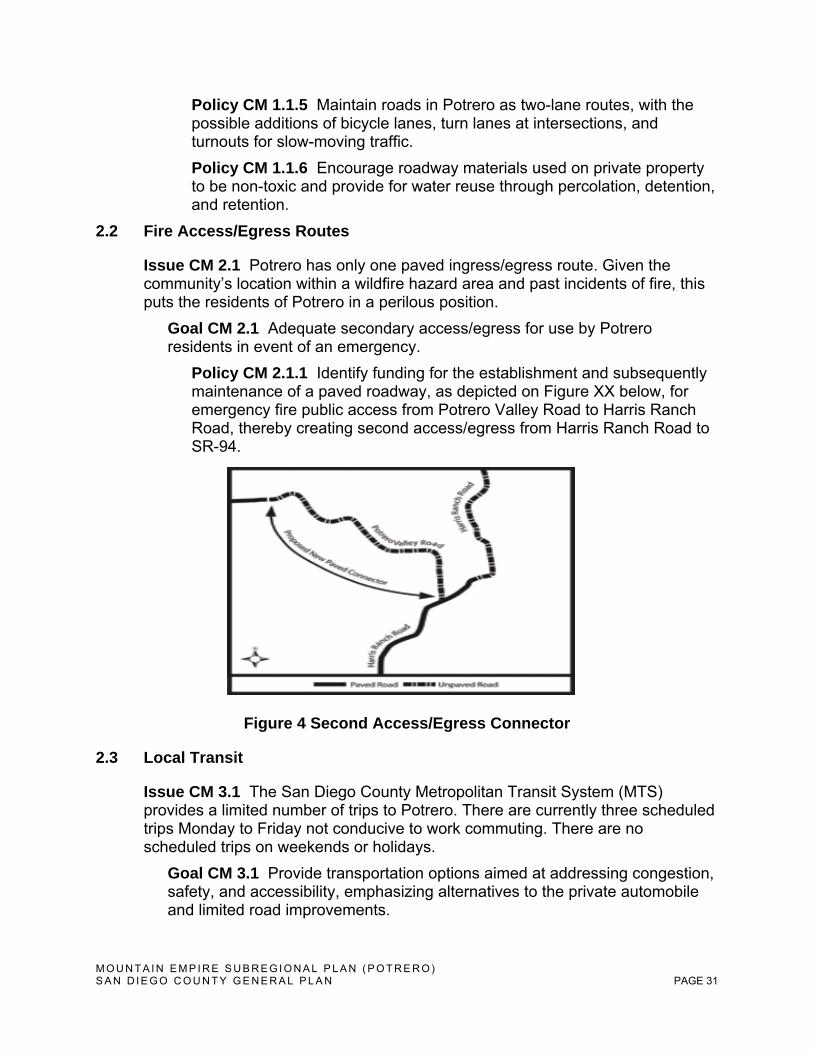
2.2 Fire Access/Egress Routes
Issue CM 2.1 Potrero has only one paved ingress/egress route. Given the community’s location within a wildfire hazard area and past incidents of fire, this puts the residents of Potrero in a perilous position.
Goal CM 2.1 Adequate secondary access/egress for use by Potrero residents in event of an emergency.
Policy CM 2.1.1 Identify funding for the establishment and subsequently maintenance of a paved roadway, as depicted on Figure XX below, for emergency fire public access from Potrero Valley Road to Harris Ranch Road, thereby creating second access/egress from Harris Ranch Road to SR-94.
Figure 4 Second Access/Egress Connector
2.3 Local Transit
Issue CM 3.1 The San Diego County Metropolitan Transit System (MTS) provides a limited number of trips to Potrero. There are currently three scheduled trips Monday to Friday not conducive to work commuting. There are no scheduled trips on weekends or holidays.
Goal CM 3.1 Provide transportation options aimed at addressing congestion, safety, and accessibility, emphasizing alternatives to the private automobile and limited road improvements.

M O U N T A I N E M P I R E S U B R E G I O N A L P L A N ( P O T R E R O ) S A N D I E G O C O U N T Y G E N E R A L P L A N PAGE 32
Policy CM 3.1.1 Identify opportunities for improved MTS service to and from Potrero including, but not limited to, increased trip frequency and weekend service.
Policy CM 3.1.2 Coordinate existing and new trip schedules to allow greater compatibility with commuter work schedules.
Policy CM 3.1.3 Work with MTS to create a monthly, rural transit pass with a further reduced fare or other incentive as a method to increase ridership, make fares more affordable and decrease automobile dependence.
2.4 Trails
Issue CM 4.1 Potrero has an abundance of open space and public lands but lacks an interconnected, multi-modal trail network for non-motorized travel.
Goal CM 4.1 Interconnected public access trails that facilitate active recreation and appreciation of Potrero’s natural assets, considering appropriate users to reduce conflicts and potential impacts to natural resources.
Policy CM 4.1.1 Identify suitable locations for public access trails, including but not limited to a connection beginning in Potrero Regional Park, passing through Hauser Canyon, Lake Morena Park and ultimately connecting with the Pacific Crest National Scenic Trail.
Policy CM 4.1.2 Situate trails at adequate distances from streams to protect riparian habitat and wildlife corridors. Trails may occasionally diverge close to the top of the bank to provide visual access and opportunities for interpretive displays on the environmental sensitivity of creek habitats.
Policy CM 4.1.3 Develop a plan to amend the San Diego County Regional Trail System and Community Trails Master Plan to include new public trail(s) within the Community of Potrero.
Policy CM 4.1.4 Identify suitable locations for equestrian staging and riding in coordination with the Potrero Planning Group, Parks and Recreation and other interested parties.
2.5 Trip Reduction Strategies
Issue CM 5.1 Excessive single-driver trips contribute to regional traffic congestion and reduced air quality.
Goal CM 5.1 Affordable and convenient transportation alternatives that reduce our dependence on single occupancy vehicles, conserve resources, improve air quality, and reduce traffic congestion.
M O U N T A I N E M P I R E S U B R E G I O N A L P L A N ( P O T R E R O ) S A N D I E G O C O U N T Y G E N E R A L P L A N PAGE 33
Policy CM 5.1.1 Encourage use of the existing Park and Ride lot on Route 94 through increased education and community awareness.
2.6 Parking
Issue CM 6.1 Paved off-street parking may adversely impact Potrero’s rural character either due to its size or design.
Goal CM 6.1 On-site parking spaces associated with redevelopment or new development that minimize impervious surface area and include ample landscaping to blend with the area’s rural character.
Policy CM 6.1.1 Permit the installation of only those off-street parking spaces necessary to satisfy the Zoning Regulations minimum requirement(s) within impervious surface parking areas. Any proposed spaces above the minimum parking space requirement shall be reasonably related to an expected demand and placed within pervious surface parking areas including ample native drought-tolerant landscaping.
2.8 Infrastructure and Utilities
a. Water
Issue CM 8.1 Potrero’s rural character and abundant open space is, in part, the result of its dependency upon groundwater. The construction of a new water delivery device or facility to supplement existing well water supplies would induce development inconsistent with Potrero’s rural character. Potrero relies upon a finite source of groundwater to sustain its residents, its limited commerce and its agricultural activities. Uncontrolled extraction may jeopardize the health, safety and welfare of Potrero’s citizens.
Goal CM 8.1 Adequate and sustainable well yields, for both individual properties and the whole groundwater basin upon which Potrero is dependent. Water delivery limited to a level supportive of the low density of development indicated on the Potrero Land Use Plan.
Policy CM 8.1.1 Prohibit new privately and publicly owned water delivery facilities serving more than one private property owner.
Policy CM 8.1.2 Prohibit the exportation of groundwater from Potrero and prohibit the importation of water, from any commercial or private source, that would promote or enable any development that would be inconsistent with Potrero's community character.
Policy CM 8.1.3 Discourage land use types which require large quantities of groundwater or that put the purity of the groundwater at risk, including but not limited to hotels, motels and golf courses.
M O U N T A I N E M P I R E S U B R E G I O N A L P L A N ( P O T R E R O ) S A N D I E G O C O U N T Y G E N E R A L P L A N PAGE 34
Policy CM 81.4 Prohibit new development from depleting groundwater reserves, contravening existing water rights, interfering with the economic advantages of pumping, excessively depleting stream flows, impacting groundwater-dependent vegetation, and resulting in land subsidence, or otherwise degrading water quality.
Implementation Program CM 8.1.1 The County shall monitor groundwater levels throughout the community plan area and consider regulatory measures if long-term depletion of groundwater resources is occurring.
Implementation Program CM 8.1.2 San Diego County Groundwater Ordinance (Title 6, Division 7, Chapter 7); County Standards for Site Specific Hydrogeologic Investigations; California Environmental Quality Act (CEQA) including, but not limited to, San Diego County Guidelines for Determining Significance and Report Format and Content Requirements: Groundwater Resources.
b. Sewer/septic
Issue CM 8.2 Potrero’s rural character and abundant open space is, in part, the result of a lack of wastewater treatment facilities. The construction of a new private or public wastewater treatment facility could induce development inconsistent with Potrero’s rural character.
Goal CM 8.2 Wastewater treatment that is consistent with a level supportive of the low density of development indicated on the Potrero Land Use Plan.
Policy CM 8.2.1 Prohibit privately and publicly owned wastewater treatment facilities serving more than one private property owner, except where needed to provide for the public health and safety.
c. Energy
Issue CM 8.3 Energy projects may include structural elements that, due to size or scale, are inconsistent with Potrero’s rural character. They may also include noise-generating elements that detract from Potrero’s quiet ambience.
Goal CM 8.3 The prolific use of alternative energy sources that serve individual buildings and are consistent with Potrero’s rural character.
Policy CM 8.3.1 Discourage the location of overhead electricity transmission lines and solar or wind farms.
Policy CM 8.3.2 Promote increases in the amount of energy produced through locally available energy sources only when the resulting technological design approach is consistent with Potrero’s rural character and scenic qualities.
M O U N T A I N E M P I R E S U B R E G I O N A L P L A N ( P O T R E R O ) S A N D I E G O C O U N T Y G E N E R A L P L A N PAGE 35
d. Telecommunications
Issue CM 8.4 Telecommunication facilities can improve the quality of life through enhanced communication. However, telecommunication facilities that are improperly sited and designed may diminish the quality of scenic roadways and vistas, and Potrero’s rural character.
Goal CM 8.4 Reduce the visibility of telecommunication facilities through citing away from prominent ridgelines, and using stealth design approaches and co-location.
Policy CM 8.4.1 To the extent allowed by law, telecommunications facilities and transmission lines shall not be located within view of any scenic roadway unless they are sited and designed so as to be virtually invisible to the naked eye from the roadway, are designed to appear as a natural feature of the environment and do not block views or disrupt scenic vistas, or are so well architecturally-integrated into an existing building as to effectively be unnoticeable.
Policy CM 8.4.2 The County shall support the expansion of telecommunication services to Potrero, consistent with General Plan and Community Plan policies and other applicable state and federal regulations, when such services are needed to support the development of locally appropriate jobs and services, including home-based businesses.
M O U N T A I N E M P I R E S U B R E G I O N A L P L A N ( P O T R E R O ) S A N D I E G O C O U N T Y G E N E R A L P L A N PAGE 36
3. Conservation and Open Space
3.1 Resource Conservation and Management
a. Agricultural soils and production
Issue COS 1.1 Potrero contains agricultural land that contributes to the local economy and continuation of the community’s open space and rural character.
Goal COS 1.1 The preservation of existing agricultural land uses, such as traditional cattle grazing and dry land farming practices, and the continued planning for sustainable agriculture and related activities such as low water consumption and organic growing methods that preserve open space, wildlife habitats, along with Potrero’s rural character.
Policy COS 1.1.1 Encourage the establishment of new Williamson Act contracts including renewal of existing contracts.
Policy COS 1.1.2 Encourage local agricultural producers to become recognized as Organic growers and participate in a Community Supported Agriculture (CSA) program.
Policy COS 1.1.3 Minimize pesticide and herbicide use and encourage research and use of integrated pest control methods such as cultural practices, biological control, host resistance, and other factors.
Policy COS 1.1.4 Prohibit new large-scale industrial agricultural operations such as producers of poultry, swine, beef and their corresponding feed lots from impacting existing non-compatible development.
Policy COS 1.1.5 Encourage food production of all kinds in individual buildings and on their lots consistent with their setting in order to promote decentralization, self-sufficiency, and reduced transportation impacts on the environment.
Implementation Program COS 1.1.1 San Diego County Department of Agriculture, Weights and Measures.
b. Plant and animal habitats and wildlife corridors
Issue COS 1.2 As confirmed by the County’s Multi-Species Habitat Conservation Plan, Potrero provides habitat for many rare, threatened, and endangered plant and animal species. The community’s open space must, therefore, be protected and enhanced as an important natural resource and wildlife habitat.
Goal COS 1.2 Effectively managed and enhanced native habitat, which maintains viable native plant and animal populations, provides for improved biodiversity and protects sensitive resources throughout Potrero.
M O U N T A I N E M P I R E S U B R E G I O N A L P L A N ( P O T R E R O ) S A N D I E G O C O U N T Y G E N E R A L P L A N PAGE 37
Policy COS 1.2.1 Support programs and proven methods to limit the impacts of “Gold-spotted Oak Borer” mortality and any other diseases harmful to native vegetation and wildlife in Potrero.
Policy COS 1.2.2 Encourage the use of integrated pest management and organic practices to manage pests with the least possible hazard to the environment. Restrict the use of insecticides, herbicides, or any toxic chemical substance in sensitive habitats, except when an emergency has been declared; the habitat itself is threatened; a substantial risk to public health and safety exists, including maintenance for flood control; or such use is authorized pursuant to a permit issued by the agricultural commissioner.
Policy COS 1.2.3 Ensure that important corridors for wildlife movement and dispersal are protected as a condition of discretionary permits, including consideration of cumulative impacts. Features of particular importance to wildlife for movement may include riparian corridors and ridgelines. Linkages and corridors shall be provided that connect sensitive habitat areas such as woodlands, forests, wetlands, and essential habitat for special-status species, including an assessment of cumulative impacts.
Policy COS 1.2.4 Encourage the adoption of a Tree Preservation or Tree Protection Ordinance.
Policy COS 1.2.5 Protect large native trees, trees with historical importance; oak woodlands; and trees with known raptor sites. Prevent the untimely removal of trees through avoidance or incorporation into landscape planting designs.
Policy COS 1.2.6 Restrict or modify proposed development in areas that contain essential habitat for special-status species, sensitive natural communities, wetlands and riparian habitats, as necessary to ensure the continued health and survival of these species and sensitive areas. Development projects should preferably be modified to avoid impacts on sensitive resources, or to adequately mitigate impacts by providing on-site or (as a lowest priority) off-site replacement at a higher ratio.
Goal COS 1.3 Limited development near creeks, streams and ponds that protects riparian habitat and prohibits their channelization or damming.
Policy COS 1.3.1 Encourage riparian habitat to be retained for conservation purposes, and require development adjacent to creeks, streams and ponds to mitigate for impacts to this habitat.
c. Scenic resources and highways
Issue COS 1.3 Potrero has an abundance of scenic resources to be protected and enhanced. It offers views of distinctive topography, climate, vegetation, wildlife, land use and life style. SR-94 is part of the County Scenic Highway System.
M O U N T A I N E M P I R E S U B R E G I O N A L P L A N ( P O T R E R O ) S A N D I E G O C O U N T Y G E N E R A L P L A N PAGE 38
Goal COS 1.3 The protection and enhancement of scenic resources, view corridors and valley views.
Policy COS 1.3.1 Prohibit billboards and off-premise commercial signage in Potrero.
Policy COS 1.3.2 Minimize vehicular access to Route 94 wherever possible and, when concerning multiple properties, consolidate them into single points of ingress/egress when consistent with public safety.
Policy COS 1.3.3 Prohibit grading on slopes exceeding 25% except for access purposes and when no less environmentally damaging alternative is possible.
Policy COS 1.3.4 Encourage water tanks be painted and/or screened with ample landscaping to minimize visual impacts.
Policy COS 1.3.5 Discourage the use of manufactured slopes yet, when infeasible to avoid the use of such slopes, they shall be rounded and contoured to resemble natural slopes.
Policy COS 1.3.6 Promote and support the designation of SR-94 as a State Scenic Highway, while maintaining the integrity of Potrero Valley Road from State Route 94 to Potrero County Park as a local scenic route.
Policy COS 1.3.7 Require fences proposed in proximity to roadways providing views to be placed, sized and designed to prevent view obstruction.
d. Surface, groundwater, and watersheds
Issue COS 1.4 New development or redevelopment may adversely impact the quality of groundwater or surface water. Uncontrolled stormwater runoff may cause unnecessary erosion and not capture opportunities for groundwater recharge.
Goal COS 1.4 Site design strategies which minimize the quantity and improve the quality of stormwater from new development and redevelopment.
Policy COS 1.4.1 Protect bodies of water and their natural watersheds wherever possible, along with the natural systems which promote recharge of aquifers and prevent flooding.
Implementation Program COS 1.4.1 County of San Diego Municipal Stormwater Permit (Regional Water Quality Control Board (RWQCB) Order No. R9-2007-0001; County of San Diego Low Impact Development Handbook (December 31, 2007).
M O U N T A I N E M P I R E S U B R E G I O N A L P L A N ( P O T R E R O ) S A N D I E G O C O U N T Y G E N E R A L P L A N PAGE 39
Issue COS 1.4 Potrero includes areas of potential flooding not depicted on Federal Emergency Management Agency (FEMA) Flood Insurance Rate Maps (FIRMs). Consideration of County prepared maps identifying additional flood risk areas not shown in FIRMS should occur during the development review process (see Figure 5 – One Hundred Year Floodplain Maps.
Goal COS 1.5 The maximum avoidance practicable to developed property (existing or proposed) and its accompanying public infrastructure from flood risks.
Policy COS 1.5.1 Preserve, to the extent practicable, lands subject to flood risk as open space and/or agricultural uses, facilitating natural and agricultural uses.
Policy COS 1.5.2 Require lot sizes in flood hazard areas be of sufficient size to include a main house and accessory buildings without impacting flood hazard area.
Policy COS 1.5.3 Encourage flood control reduction projects to give full consideration to scenic, fish, wildlife and other environmental benefits when computing costs of alternative methods of flood control
Policy COS 1.5.4 Require proposed projects in a floodplain to include an evaluation of potential flood impacts that may result from the projects.
Implementation Program COS 1.5.1 County of San Diego Floodplain Management Plan, County of San Diego Watershed Protection, Stormwater Management, and Discharge control Ordinance, and San Diego County Hydrology Manual
e. Mineral resources
Issue COS 1.5 Despite one known historic mining activity, the geologic opportunities for future mineral extraction in Potrero are not clearly known. Should mineral resources be discovered in the future, extraction techniques and corresponding landform changes would be inconsistent with Potrero’s rural character depending upon their proposed location.
Goal COS 1.5 Protect Potrero’s rural character and compatible land uses by directing mineral resource extraction such as sand, gravel and other mineral mining to appropriate locations.
Policy COS 1.5.1 Direct mineral extraction activities to locations not providing or containing wetlands, sensitive species or their habitat or views from scenic roadways.
Policy COS 1.5.2 Provide sufficient buffers between designated mineral resource sites or potential extraction areas and uses incompatible with mining, such as housing.
M O U N T A I N E M P I R E S U B R E G I O N A L P L A N ( P O T R E R O ) S A N D I E G O C O U N T Y G E N E R A L P L A N PAGE 40
Policy COS 1.5.3 Require best available management practices through the use-permit or other discretionary permit process to minimize or avoid nuisances, view impacts, hazards, or adverse environmental impacts.
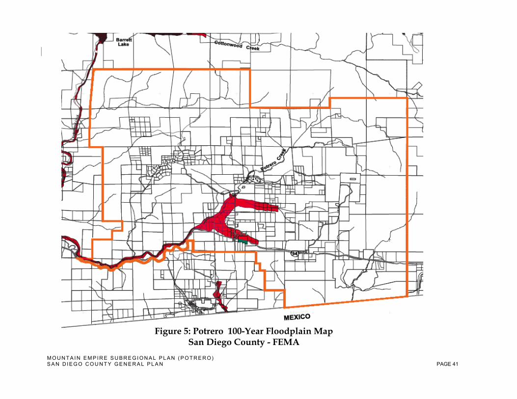
M O U N T A I N E M P I R E S U B R E G I O N A L P L A N ( P O T R E R O ) S A N D I E G O C O U N T Y G E N E R A L P L A N PAGE 41
Figure 5: Potrero 100-Year Floodplain Map San Diego County - FEMA

M O U N T A I N E M P I R E S U B R E G I O N A L P L A N ( P O T R E R O ) S A N D I E G O C O U N T Y G E N E R A L P L A N PAGE 42
Figure 6: Potrero 100-Year Floodplain Map San Diego County Department of Public Works (DPW)
M O U N T A I N E M P I R E S U B R E G I O N A L P L A N ( P O T R E R O ) S A N D I E G O C O U N T Y G E N E R A L P L A N PAGE 43
f. Air quality
Issue COS 1.6 Clean, fresh air is one of Potrero’s most unique and valuable assets.
Goal COS 1.6 Clean air that minimizes the potential impacts from land uses that may emit pollution and/or harmful odors to sensitive land uses, while acknowledging some odors that are part of Potrero’s rural and agricultural character.
Policy COS 1.6.1 Discourage odors associated with commercial uses - in particular, those generated by chemical or industrial processes - and require development to mitigate their effects on nearby businesses and residences in accordance with standards of the San Diego Air Pollution Control District (SDAPCD).
f. Water and energy
Issue COS 1.7 Potrero is totally dependent on groundwater and has been subject to prolonged droughts. Wasteful use of this finite resource jeopardizes the health, safety and welfare of Potrero and its environs.
Goal COS 1.7 Protect the quality and quantity of groundwater and encourage water conservation community-wide.
Policy COS 1.7.1 The County shall promote cost-effective water conservation and water efficiency measures that reduce water loss, waste, and water demand.
Policy COS 1.7.2 All aspects of landscaping from the selection of plants to soil preparation and the installation of irrigation systems should be designed to reduce water demand, retain runoff, decrease flooding, and recharge groundwater.
Issue COS 1.8 Buildings may excessively consume resources such as energy, water, and materials, and may have impacts upon human health and the environment during their lifecycle. Consideration should be given to counter these outcomes through better approaches to siting, design, construction, operation, maintenance, and removal.
Goal COS 1.8 Promote “green building” as a method to efficiently use energy, water, and other resources, to protect occupant health and improve employee productivity, and to reduce waste, pollution and environmental degradation.
Policy COS 1.8.1 Building materials should be rapidly renewable, salvaged, recycled, recyclable and have low embodied energy. Alternatively, materials should be chosen for their durability, exceptional longevity and sound construction, taking advantage of thermal mass properties to reduce energy usage.

M O U N T A I N E M P I R E S U B R E G I O N A L P L A N ( P O T R E R O ) S A N D I E G O C O U N T Y G E N E R A L P L A N PAGE 44
Policy COS 1.8.2 Promote the use of small-scale advanced and renewable energy technology by encouraging the use of renewable resources in residential, commercial, and agricultural projects and uses.
Policy COS 1.8.3 Increase the amount of energy produced through locally available energy sources only when the resulting technological design approach is consistent with Potrero’s rural character and scenic qualities.
Policy COS 1.8.4 Reduce the energy impacts from new buildings by applying Title 24 energy standards as required by law and providing information to the public and builders on available energy conservation techniques, products, and methods available to exceed those standards by 15 percent or more.
Policy COS 1.8.5 Require “green building” design, development, and construction through the achievement of Leadership in Energy and Environmental Design (LEED) standards set by the U.S. Green Building Council, the Green Point Rated system standards set by Builditgreen.org, or equivalent programs. Actions in support of this policy shall include:
a. Amend the County Code as necessary to remove barriers to and encourage “green” construction.
b. Encourage all new development projects and major renovation of existing facilities to be based on Green Building Council standards utilizing sustainable construction and practices to achieve a minimum LEED rating of Silver, or comparable level on the Green Point Rated system per standards set by Builditgreen.org or other comparable updated rating systems; and
c. Support state and federal incentive programs that offer rebates and cost sharing related to the implementation of “green building” standards and LEED certification.
M O U N T A I N E M P I R E S U B R E G I O N A L P L A N ( P O T R E R O ) S A N D I E G O C O U N T Y G E N E R A L P L A N PAGE 45
3.2 Parks and Recreation
a. Park needs, locations, and facilities
Issue COS 2.1 The Potrero Regional Park provides a valuable amenity to local residents and visitors. Its maintenance and enhancement will provide a civic amenity for residents and visitors to coalesce around.
Goal COS 2.1 Continued utilization of Potrero Regional Park as the focal point for outdoor recreation where the Park’s amenities are maintained and enhanced consistent with community needs.
Policy COS 2.1.1 Encourage the formation of a subcommittee to, when necessary, work on Potrero Regional Park recreational program issues and provide advice to County staff and the Park Advisory Committee.
Policy COS 2.1.2 Investigate and, where appropriate, pursue opportunities for equestrian uses, along with the construction of tennis and basketball courts at Potrero Regional Park including facilities needed to accommodate their special access needs.
b. Commercial recreation facilities
Issue COS 2.2 Recreational amenities in Potrero contribute to the community’s rural character by incorporating and highlighting nature with minimal use of pavement, lighting, and built structures. Commercial recreation facilities including, but not limited to, play fields and racetracks with nighttime lighting are inconsistent with Potrero’s character.
Goal COS 2.2 Recreation facilities that incorporate nature through minimal structural improvement and an absence of lighting.
Policy COS 2.2.1 Encourage recreation facilities that contribute to Potrero’s rural character and incorporate nature, while being constructed with minimal structural improvements and an absence of lighting.
Policy COS 2.2.2 Prohibit recreational facilities that include nighttime lighting, off-road vehicles or all-terrain vehicles.
M O U N T A I N E M P I R E S U B R E G I O N A L P L A N ( P O T R E R O ) S A N D I E G O C O U N T Y G E N E R A L P L A N PAGE 46
3.3 Dark Skies
Issue COS 3.1 Dark skies are a natural resource in the community of Potrero. Excessive outdoor lighting can brighten its dark skies and, thereby, impact the community character of this rural area, diminish views of the night sky, and critically reduce amateur astronomers efforts to observe and study the cosmos.
Goal COS 3.1 A night sky that is not impacted by sky glow, light trespass and/or glare caused by public and private improvements, but retains Potrero’s rural character, to preserve unspoiled views of the night sky and enable amateur astronomer’s activities.
Policy COS 3.1.1 Require that both public and private development projects within the community of Potrero minimize contributing to significant sky glow, light trespass, and glare.
Policy COS 3.1.2 All exterior lighting to be limited to what is necessary for safety and security.
Policy COS 3.1.3 Restrict recreational amenities at Potrero Regional Park and commercial recreation facilities from the use of nighttime lighting for uses, other than pedestrian and vehicle circulation needs or to protect public safety, which include the lowest possible luminescence.
Implementation Program COS 3.1.1 Light Pollution Code (Title 5, Division 9, Sections 59.101-59.113); Zoning Ordinance (Performance Standards) Sections 6320, 6322, 6324; Guidelines for Determining Significance and Report Format and Content Requirements: Dark Skies and Glare, dated July 30, 2007.
M O U N T A I N E M P I R E S U B R E G I O N A L P L A N ( P O T R E R O ) S A N D I E G O C O U N T Y G E N E R A L P L A N PAGE 47
4. Safety 4.1 Hazards/Risk Avoidance and Mitigation
a. Wildland fire/Urban fire
Issue S 1.1 Potrero is located within a mapped Wildland Urban Interface area. This has significant implications for wildfire management including the potential for wildfires to threaten structures and people. The Wildland Urban Interface creates an environment in which fire can move readily between structural and vegetation fuels.
Goal S 1.1 Residents in Potrero who have been educated to take all precautions to prevent and, if necessary, to respond to wildland fire disasters to minimize loss of life and property, should they occur.
Policy S 1.1.1 Promote implementation of a “Potrero Firewise” program through information and education programs, community outreach, and fuel modification.
Policy S 1.1.2 Provide residents with landscape and vegetation management tips in selecting fire-resistant plants and vegetation clearing methods.
Policy S 1.1.3 Pursue funding and a program to assist low-income residents and senior citizens in maintaining defensible space.
b. Emergency Preparedness and Response
Issue S 1.2 Potrero is particularly susceptible to three natural disaster types: wildfire, floods, and earthquakes. Community awareness and education are vital in a rural community such as Potrero.
Goal S 1.2 Central, easily identifiable and accessible locations and materials for community education on issues of emergency preparedness.
Policy S 1.2.1 Pursue options, including funding mechanisms, to assist in the maintenance of the Volunteer Fire Department and Kiwanis Community Center as central locations for emergency preparedness education.
M O U N T A I N E M P I R E S U B R E G I O N A L P L A N ( P O T R E R O ) S A N D I E G O C O U N T Y G E N E R A L P L A N PAGE 48
5. Noise 5.1 Noise Standards and Mitigation
Issue N 1.1 Noise is unwanted sound. Potrero maintains a quiet environment with low, mobile ambient noise levels limited to Route 94.
Goal N 1.1 Accept those sounds that are part of Potrero’s rural character while protecting residents from exposure to excessive mobile and stationary noise sources.
Policy N 1.1.1 Support and understand that noises associated with agriculture, including agricultural processing, are considered an acceptable and necessary part of the community character of Potrero, and are not considered to be undesirable provided that normal and reasonable measures are taken to avoid significantly impacting adjacent uses.
Policy N 1.1.2 Limit noise impacts of commercial recreational uses - including shooting ranges and other noise-producing equipment - through the enforcement of applicable laws (such as requirements for mufflers) and limits on the location and/or extent of such uses.
M O U N T A I N E M P I R E S U B R E G I O N A L P L A N ( P O T R E R O ) S A N D I E G O C O U N T Y G E N E R A L P L A N PAGE 49
ADDENDUM
APPENDICES
APPENDIX A – POTRERO PLANNING AREA MAP
APPENDIX B – POTRERO TOPOGRAPHICAL MAP
APPENDIX C – POTRERO AGGREGATED VEGETATION MAP
APPENDIX D – POTRERO RARE, THREATENED & ENDANGERED SPECIES LIST
APPENDIX E – POTRERO EXISTING LAND USE % MAP
APPENDIX F – POTRERO PLANNING GROUP RECOMMENDATION 2008 - Modified and adopted by the Potrero Planning Group, August 14, 2008. PHOTOGRAPHS: PHOTOGRAPH PAGE 1 – HAUSER MT_HAUSER CANYON PHOTOGRAPH PAGE 2 – MCALMOND HOUSE_METATE PHOTOGRAPH PAGE 3 – POTRERO PARK_ENDANGERED SPECIES PHOTOGRAPH PAGE 4 – POTRERO LIBRARY_GENERAL STORE PHOTOGRAPH PAGE 5 – ANTI-BLACKWATER_HARRIS FIRE
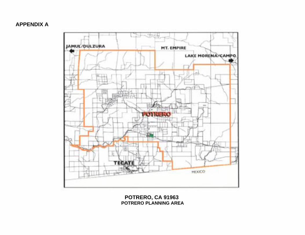
APPENDIX A
POTRERO, CA 91963 POTRERO PLANNING AREA
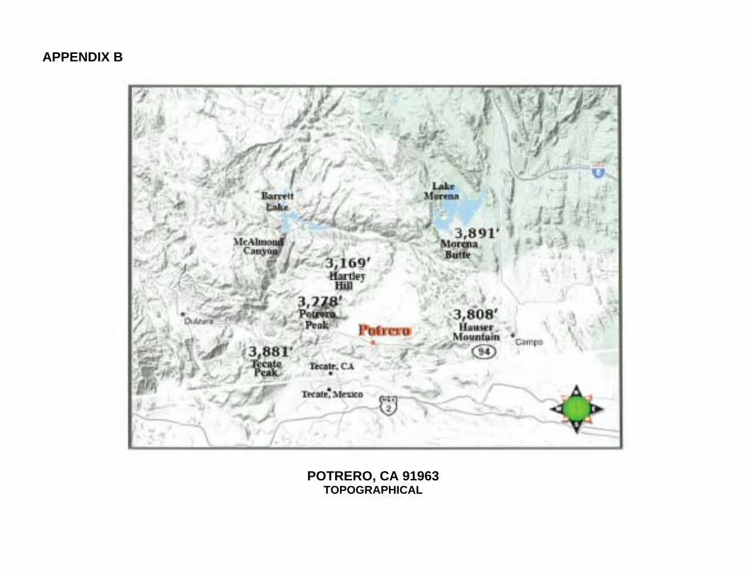
APPENDIX B
POTRERO, CA 91963 TOPOGRAPHICAL
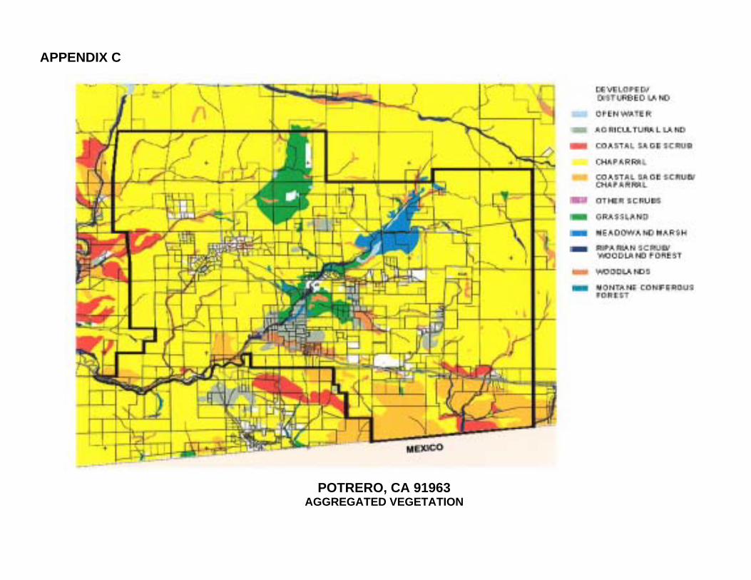
APPENDIX C
POTRERO, CA 91963 AGGREGATED VEGETATION
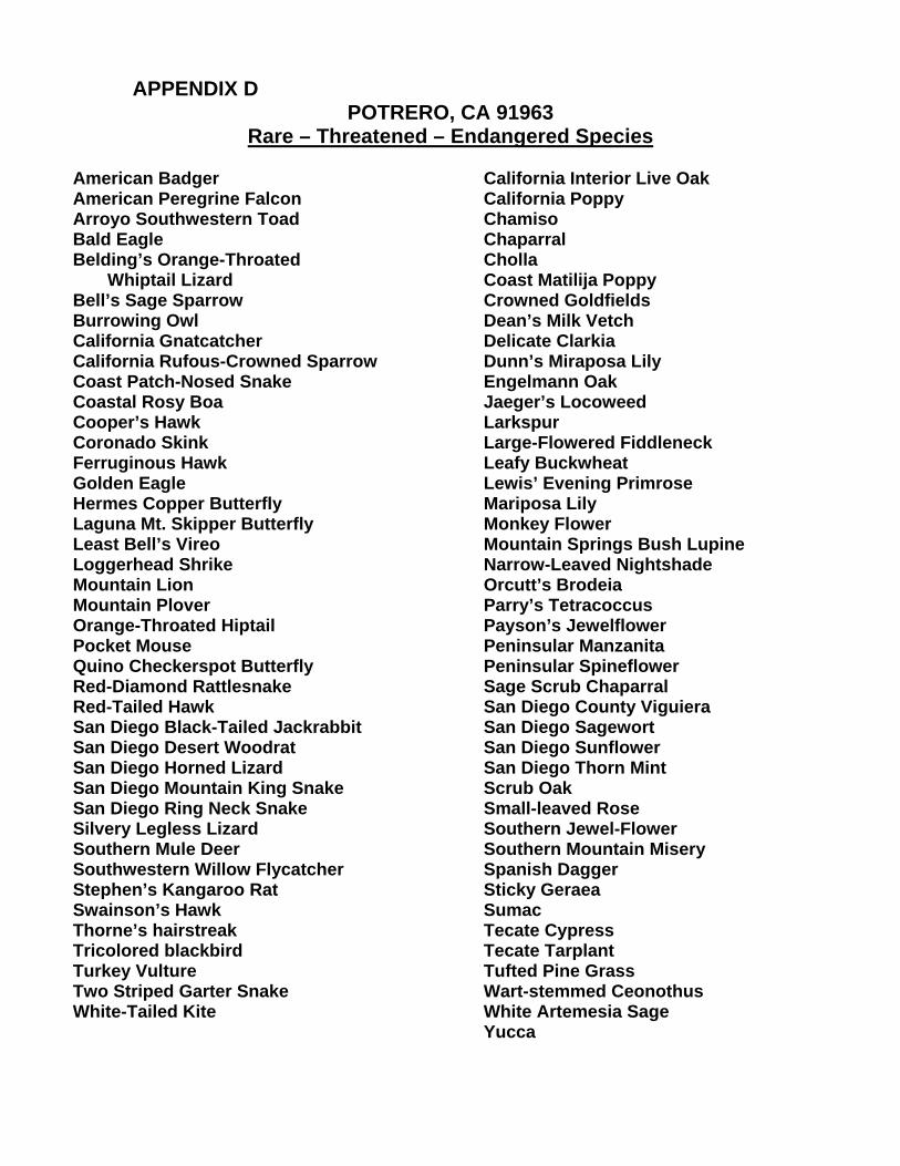
APPENDIX D
POTRERO, CA 91963 Rare – Threatened – Endangered Species
American Badger American Peregrine Falcon Arroyo Southwestern Toad Bald Eagle Belding’s Orange-Throated Whiptail Lizard Bell’s Sage Sparrow Burrowing Owl California Gnatcatcher California Rufous-Crowned Sparrow Coast Patch-Nosed Snake Coastal Rosy Boa Cooper’s Hawk Coronado Skink Ferruginous Hawk Golden Eagle Hermes Copper Butterfly Laguna Mt. Skipper Butterfly Least Bell’s Vireo Loggerhead Shrike Mountain Lion Mountain Plover Orange-Throated Hiptail Pocket Mouse Quino Checkerspot Butterfly Red-Diamond Rattlesnake Red-Tailed Hawk San Diego Black-Tailed Jackrabbit San Diego Desert Woodrat San Diego Horned Lizard San Diego Mountain King Snake San Diego Ring Neck Snake Silvery Legless Lizard Southern Mule Deer Southwestern Willow Flycatcher Stephen’s Kangaroo Rat Swainson’s Hawk Thorne’s hairstreak Tricolored blackbird Turkey Vulture Two Striped Garter Snake White-Tailed Kite
California Interior Live Oak California Poppy Chamiso Chaparral Cholla Coast Matilija Poppy Crowned Goldfields Dean’s Milk Vetch Delicate Clarkia Dunn’s Miraposa Lily Engelmann Oak Jaeger’s Locoweed Larkspur Large-Flowered Fiddleneck Leafy Buckwheat Lewis’ Evening Primrose Mariposa Lily Monkey Flower Mountain Springs Bush Lupine Narrow-Leaved Nightshade Orcutt’s Brodeia Parry’s Tetracoccus Payson’s Jewelflower Peninsular Manzanita Peninsular Spineflower Sage Scrub Chaparral San Diego County Viguiera San Diego Sagewort San Diego Sunflower San Diego Thorn Mint Scrub Oak Small-leaved Rose Southern Jewel-Flower Southern Mountain Misery Spanish Dagger Sticky Geraea Sumac Tecate Cypress Tecate Tarplant Tufted Pine Grass Wart-stemmed Ceonothus White Artemesia Sage Yucca
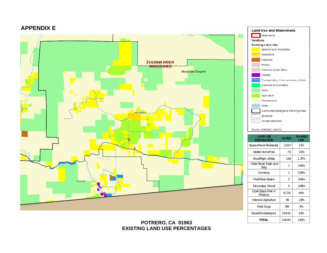
APPENDIX E
LAND USE
DESIGNATION ACRES
% LANDUSE
Spaced Rural Residential 2,567 11%
Mobile Home Park 76 .31%
Road Right of Way 188 1.27%
Other Retail Trade andStrip 1 .024%
Cemetery 1 .024%
Fire/Police Station 5 .044%
Elementary School 6 .048%Open Space Park or
Preserve 9,726 40%
Intensive Agriculture 99 .28%
Field Crops 944 4%
Vacant/Undeveloped 10,436 43%
TOTAL: 24,049 100%
POTRERO, CA 91963 EXISTING LAND USE PERCENTAGES
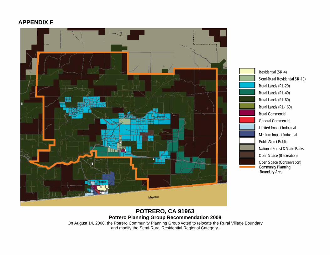
APPENDIX F
Residential (SR-4)
Semi-Rural Residential SR-10)
Rural Lands (RL-20)
Rural Lands (RL-40)
Rural Lands (RL-80)
Rural Lands (RL-160)
Rural Commercial
General Commercial
Limited Impact Industrial
Medium Impact Industrial
Public/Semi-Public
National Forest & State Parks
Open Space (Recreation)
Open Space (Conservation) Community Planning Boundary Area
POTRERO, CA 91963 Potrero Planning Group Recommendation 2008
On August 14, 2008, the Potrero Community Planning Group voted to relocate the Rural Village Boundary and modify the Semi-Rural Residential Regional Category.

HAUSER MOUNTAIN
Potrero, CA
HAUSER CANYON
Potrero, CA
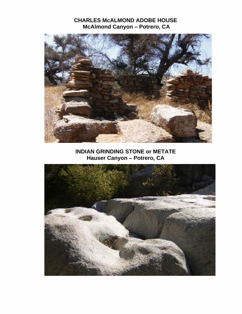
CHARLES McALMOND ADOBE HOUSE
McAlmond Canyon – Potrero, CA
INDIAN GRINDING STONE or METATE
Hauser Canyon – Potrero, CA
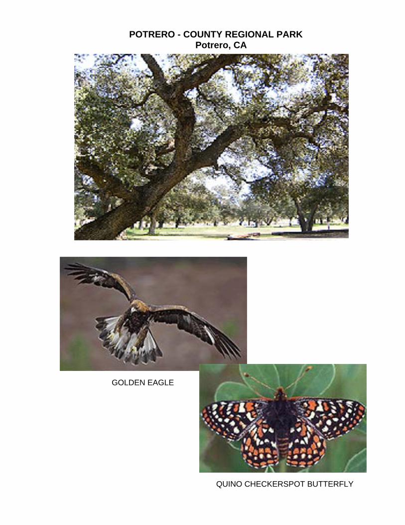
POTRERO - COUNTY REGIONAL PARK
Potrero, CA
GOLDEN EAGLE
QUINO CHECKERSPOT BUTTERFLY
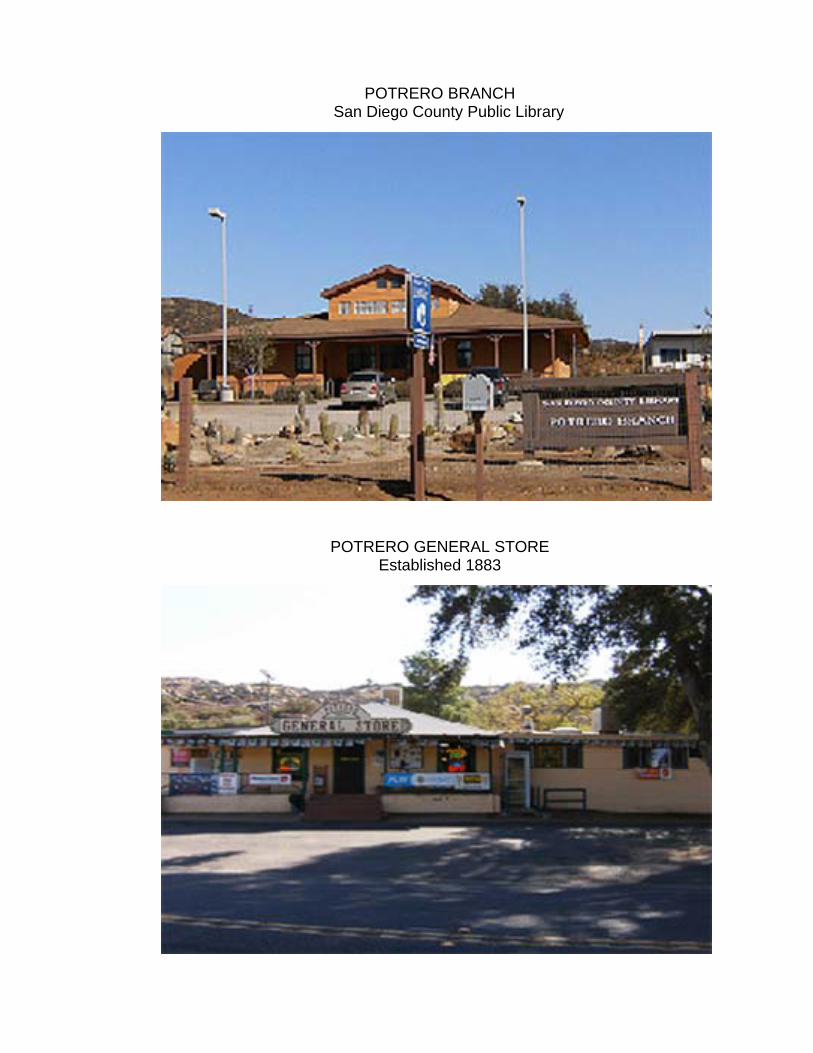
POTRERO BRANCH San Diego County Public Library
POTRERO GENERAL STORE Established 1883
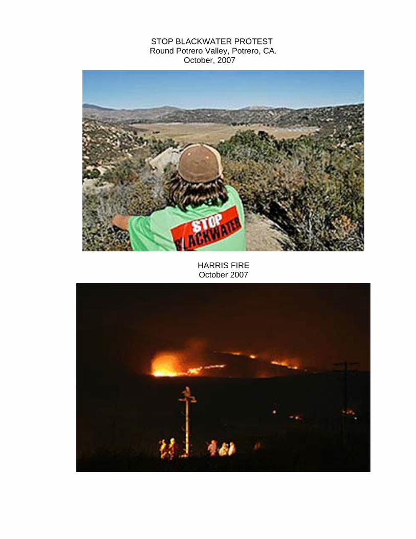
STOP BLACKWATER PROTEST Round Potrero Valley, Potrero, CA. October, 2007
HARRIS FIRE October 2007