MOUNT LOFTY RANGES, SOUTH AUSTRALIA V. Tokarev and V ...crcleme.org.au/RegLandEvol/MtLofty.pdf ·...
6
© CRC LEME 2003 Mount Lofty Ranges Page 1 MOUNT LOFTY RANGES, SOUTH AUSTRALIA V. Tokarev and V. Gostin Department Geology and Geophysics, University of Adelaide, Adelaide, SA 5005 [email protected] INTRODUCTION The Mount Lofty Ranges is an arcuate north–south oriented upland region in South Australia flanked by the St. Vincent and western Murray Basins. This paper focuses on the southern part of the Ranges between the Fleurieu Peninsula in the south and the Torrens River in the north (Figure 1). Traditionally, the Mount Lofty Ranges was considered to be an intraplate region uplifted since the early Tertiary with inherited tectonic fabrics from the Delamerian structure (~500 Ma). Previous models refer to Eocene uplift resulting from compressional reactivation along Paleozoic faults (e.g., Benbow et al., 1995; Love et al., 1995). A new model of neotectonic movements, independent of ancient tectonic fabrics controlling landscape and regolith development has been proposed by Tokarev et al. (1999). In this study we incorporate both neotectonic movements and sea-level change as factors governing landscape and regolith evolution within the southern part of the Mount Lofty Ranges. Initial tectonic forces involved subsidence and downwarping which significantly lowered the high- standing pre-Middle Eocene palaeoplain. These processes in combination with significant sea-level changes resulted in an increase of topographic relief and the stripping of regolith from the western portions of the Mount Lofty Ranges. A major sea-level fall in the Oligocene resulted in exposure of sedimentary surfaces to active weathering and pedogenesis in the southwestern part of the Murray Basin. Pleistocene uplift of the Mount Lofty Ranges changed the initial geomorphic setting including the drainage network, and preserved the watershed in the eastern portion from direct active erosion. METHODS Tertiary sequences were examined in order to elucidate stream erosional and transport capabilities, sedimentary pattern and thickness distribution. A study of the effects of sea-level fluctuations on erosional base level allowed us to isolate the response of regolith–landscape development to neotectonic movements. Palaeoplain remnants, newly created valleys, and watersheds were examined in order to obtain the main features of landscape evolution that Figure1. Location map of the Mt Lofty Ranges using a Digital Elevation Model (1 arc sec, DENR SA). The shaded landscape shows the Ranges surrounded by Tertiary and Quaternary filled basins. would correlate with sedimentation within and around the Mount Lofty Ranges. Our method included Digital Elevation Model (DEM) data processing and visualisation, geomorphological analysis, field survey, and neotectonic structural interpretation. This enabled us to define the main features of regolith–landscape response to the Middle Eocene–Middle Miocene neotectonic deformation and sea-level change. PRE-MIDDLE EOCENE PALAEOPLAIN The Gondwanan glaciation was widespread throughout the Australian continent. This glaciation played a significant role in post-Delamerian landscape planation by eroding local uplifts and infilling many small depressions. Preservation of Permian landforms and sediments within this region highlights post- Permian tectonic quiescence, landscape planation and deep weathering and thus provides important evidence of post-Middle
Transcript of MOUNT LOFTY RANGES, SOUTH AUSTRALIA V. Tokarev and V ...crcleme.org.au/RegLandEvol/MtLofty.pdf ·...

© CRC LEME 2003 Mount Lofty Ranges Page 1
MOUNT LOFTY RANGES, SOUTH AUSTRALIAV. Tokarev and V. Gostin
Department Geology and Geophysics, University of Adelaide, Adelaide, SA [email protected]
INTRODUCTION
The Mount Lofty Ranges is an arcuate north–south oriented upland region in South Australia flanked by the St. Vincent and western Murray Basins. This paper focuses on the southern part of the Ranges between the Fleurieu Peninsula in the south and the Torrens River in the north (Figure 1). Traditionally, the Mount Lofty Ranges was considered to be an intraplate region uplifted since the early Tertiary with inherited tectonic fabrics from the Delamerian structure (~500 Ma). Previous models refer to Eocene uplift resulting from compressional reactivation along Paleozoic faults (e.g., Benbow et al., 1995; Love et al., 1995). A new model of neotectonic movements, independent of ancient tectonic fabrics controlling landscape and regolith development has been proposed by Tokarev et al. (1999).
In this study we incorporate both neotectonic movements and sea-level change as factors governing landscape and regolith evolution within the southern part of the Mount Lofty Ranges. Initial tectonic forces involved subsidence and downwarping which significantly lowered the high-standing pre-Middle Eocene palaeoplain. These processes in combination with significant sea-level changes resulted in an increase of topographic relief and the stripping of regolith from the western portions of the Mount Lofty Ranges. A major sea-level fall in the Oligocene resulted in exposure of sedimentary surfaces to active weathering and pedogenesis in the southwestern part of the Murray Basin. Pleistocene uplift of the Mount Lofty Ranges changed the initial geomorphic setting including the drainage network, and preserved the watershed in the eastern portion from direct active erosion.
METHODS
Tertiary sequences were examined in order to elucidate stream erosional and transport capabilities, sedimentary pattern and thickness distribution. A study of the effects of sea-level fluctuations on erosional base level allowed us to isolate the response of regolith–landscape development to neotectonic movements. Palaeoplain remnants, newly created valleys, and watersheds were examined in order to obtain the main features of landscape evolution that Figure1. Location map of the Mt Lofty Ranges using a Digital Elevation Model (1 arc
sec, DENR SA). The shaded landscape shows the Ranges surrounded by Tertiary and Quaternary filled basins.
would correlate with sedimentation within and around the Mount Lofty Ranges. Our method included Digital Elevation Model (DEM) data processing and visualisation, geomorphological analysis, field survey, and neotectonic structural interpretation. This enabled us to define the main features of regolith–landscape response to the Middle Eocene–Middle Miocene neotectonic deformation and sea-level change.
PRE-MIDDLE EOCENE PALAEOPLAINThe Gondwanan glaciation was widespread throughout the Australian continent. This glaciation played a significant role in post-Delamerian landscape planation by eroding local uplifts and infilling many small depressions. Preservation of Permian landforms and sediments within this region highlights post-Permian tectonic quiescence, landscape planation and deep weathering and thus provides important evidence of post-Middle
© CRC LEME 2003 Mount Lofty Ranges Page 2
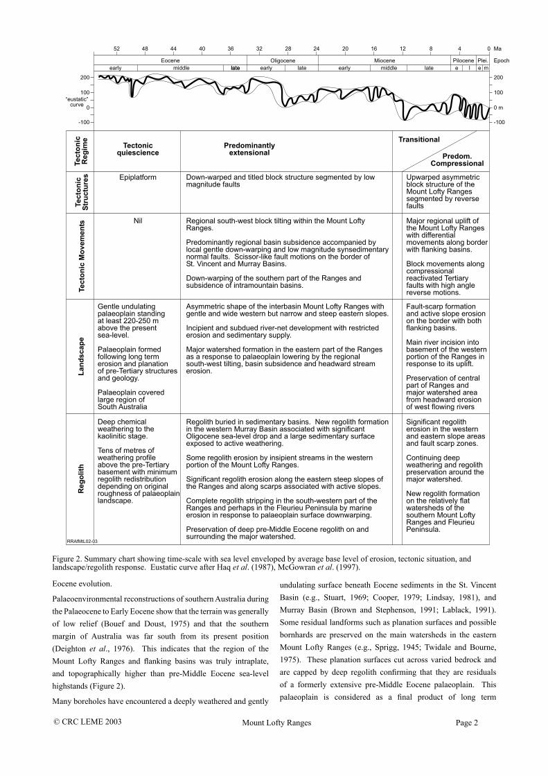
Figure 2. Summary chart showing time-scale with sea level enveloped by average base level of erosion, tectonic situation, and landscape/regolith response. Eustatic curve after Haq et al. (1987), McGowran et al. (1997).
Eocene evolution.
Palaeoenvironmental reconstructions of southern Australia during the Palaeocene to Early Eocene show that the terrain was generally of low relief (Bouef and Doust, 1975) and that the southern margin of Australia was far south from its present position (Deighton et al., 1976). This indicates that the region of the Mount Lofty Ranges and flanking basins was truly intraplate, and topographically higher than pre-Middle Eocene sea-level highstands (Figure 2).
Many boreholes have encountered a deeply weathered and gently
undulating surface beneath Eocene sediments in the St. Vincent Basin (e.g., Stuart, 1969; Cooper, 1979; Lindsay, 1981), and Murray Basin (Brown and Stephenson, 1991; Lablack, 1991). Some residual landforms such as planation surfaces and possible bornhards are preserved on the main watersheds in the eastern Mount Lofty Ranges (e.g., Sprigg, 1945; Twidale and Bourne, 1975). These planation surfaces cut across varied bedrock and are capped by deep regolith confirming that they are residuals of a formerly extensive pre-Middle Eocene palaeoplain. This palaeoplain is considered as a final product of long term

© CRC LEME 2003 Mount Lofty Ranges Page 3
erosion, denudation and deep weathering (e.g., Ollier and Pain, 2000). Applying the global sea-level curve (Haq et al., 1987; McGowran, 1989; Figure 2) this palaeoplain was located at least 220–250 m above present sea-level before Middle Eocene tectonic deformation (subsidence and downwarping) and subsequent erosion remodelled this region. Thus we consider that the deepest weathering profile was formed on the palaeoplain and therefore that the oldest regolith must be pre-Middle Eocene in age.
MIDDLE EOCENE TO MIDDLE MIOCENE TECTONICS AND REGOLITH–LANDSCAPE EVOLUTION
The global curve shows that Tertiary sea-level was generally dropping since the Palaeocene (Figure 2), and therefore sedimentary accommodation space in the St Vincent and Murray Basins must have been provided by downward neotectonic movements. “Accommodation space” is the space available for sediment accumulation controlled largely by tectonic movements, changes in sea-level, volcanic activity and compaction (Reading and Levell, 1996). Since neither volcanic activity nor sediment compaction significantly affected accommodation space, subsidence of these basins must have formed initial accommodation space as recorded by the Middle Eocene North Maslin Sand and Olney Formation. Fluvio-lacustrine deposition of these basal sediments suggests limited stream erosion and transport capabilities in the source region. Tens of metres of these basal units were deposited near the source area in both basins (Cooper, 1979; Lindsay, 1981; Brown and Stephenson, 1991). However, lenticular very fine sands, clays, and lignites of the Clinton Formation were deposited in small shallow lakes, and swamps widespread in the eastern and northern parts of the St. Vincent Basin in the Late Eocene. At the same time, carbonaceous silt, siltstone, sand and kaolinitic clay interbedded with lignitic brown coal were deposited in the western Murray Basin (the Olney Formation) near the eastern border with the Mount Lofty Ranges.
The kaolinitic clays and lignites were most likely formed on a gently undulating surface with restricted sediment supply. Wide distribution of these sediments does not suggest major uplift of nearby source areas. This indicates that the western portion of the Mount Lofty Ranges (near the Clinton depocentres) had been gently downwarped from a high standing palaeoplain. The western Murray Basin depocentres have also received limited sediment supply indicating low relief and apparently limited stream catchments on the eastern slope of the Mount Lofty Ranges. In contrast, had there been significant uplift of the Ranges at this stage, the Eocene sediments would have probably been thicker and coarser grained. Deep incision would also have provided fresh clasts of pre-Permian basement rocks, generally absent in the Eocene sands (Lindsay, 1981).
The combination of a general sea-level fall and marine inundation within the St. Vincent and western Murray Basins in the Late Eocene indicates that the high standing palaeoplain had subsided significantly. Total subsidence at the end of Eocene was probably
in the range of 250–300 m that included general sea-level fall, shallow depth of water and thickness of sediments. Such subsidence would have lowered the high-standing palaeoplain to present sea-level and initiated headward stream erosion on the margins of the Mount Lofty Ranges.
There are a significant amount of marine and marginal-marine sediments in the intramontain Hindmarsh Tiers, Myponga Basin and Meadows-Kuitpo areas (Furness et al., 1981; Lindsay and Alley, 1995). The Late Oligocene marine incursion into the southern Mount Lofty Ranges during the maximum eustatic sea-level fall is crucial evidence that downward tectonic movements affected this source region. These movements lowered the initial surface and provided accommodation space for the sediments.
The dominance of carbonates and paucity of terrigenous grains in the Late Eocene to Middle Miocene sedimentary units indicates that after the first sedimentary influx, stream erosion and transport capabilities were significantly reduced. An absence of coarse alluvial or colluvial sediments indicates the subdued character of steam transport and limited erosion into the basement. Such evidence allowed Fenner (1930, 1931) to suggest that the Mount Lofty Ranges were further eroded down to a new palaeoplain following their supposed uplift. However, sediments indicative of significant erosion of this source region to a new palaeoplain are absent in both flanking basins. Preservation of soft Permian sediments and a deep regolith are also incompatible with significant surface lowering by erosion. Thus subsidence and down-warping of the high-standing palaeoplain are more likely tectonic processes than an uplift controlled regolith–landscape development in the Mount Lofty Ranges in the Middle Eocene to Middle Miocene.
These tectonic movements explain the asymmetric shape of the incipient Mount Lofty Ranges with wide and gentle western slopes, but narrow and steep eastern slopes. Such slopes at approximately 10/1 initial areal ratios are consistent with the general pattern of the drainage system with long western and short eastern flowing rivers and streams. The major watershed is clearly associated with the eastern part of the Ranges that remained higher than the entire down-warped palaeoplain and subsiding basins. Remnants of this palaeoplain capped by deep regolith are preserved on and surround this watershed (Figure 3A). Regional geomorphological analysis shows that the process of down-warping was probably uniform throughout the source region with local variations complicated by normal fault movements.
Normal fault displacements with scissor-like motions were the most prominent type of neotectonic movements along the Para, Eden-Burnside, Clarendon and Willunga Faults on the western border of the Mount Lofty Ranges (Figure 3B). The Meadows and other unnamed faults occur in the interior of the Mount Lofty Ranges. The eastern slope of the Ranges was initially associated with downward movements along several parallel normal faults including the Encounter and Palmer Faults (eastern fault in Figure 3A). Limited coarse debris in the sedimentary sequence alongside the faults indicates that displacements were of low magnitude and

© CRC LEME 2003 Mount Lofty Ranges Page 4
Figure 3A. Block diagram of southern part of Mt Lofty Ranges showing early Tertiary faults as solid lines. Original watershed is dashed. Remnants of the oldest regolith are shown striped. Double arrows indicate possible Oligocene marine passage along the Inman/Finniss valleys. A=Adelaide CBD.
Figure 3B. Block diagram showing present topography and cross-section with buried pre-Tertiary palaeoplain and step faults active during the Tertiary. A=Adelaide CBD.
apparently contemporaneous with sedimentation. Preservation of the pre-Middle Eocene palaeoplain with a deep regolith occurred on the major watershed area due to limited topographic relief, with downwarping to sea-level resulting in limited erosion (Figure 3A).
SEA-LEVEL AS A FORCING FACTOR OF THE REGOLITH–LANDSCAPE DEVELOPMENT
In the southwestern part of the Murray Basin a major episode of weathering occurred within the Buccleuch beds (Late Eocene). This mature pedogenic surface is apparently correlated with a major sea-level drop at the end of the early Oligocene that exposed a large sedimentary surface to active weathering. This episode clearly points to the significant influence of sea-level on regolith formation. This regolith was later covered by the Compton Conglomerate at the base of the Murray Group (Brown and Stephenson, 1991).
The Compton Conglomerate typically contains pebbles, sand, glauconite and a ferruginous matrix that indicates active stripping of a regolith from a nearby source region. We believe that
significant downwarping of the southern Mount Lofty Ranges and Fleurieu Peninsula in the Late Oligocene allowed the rising sea to completely strip the deep regolith from the most of this area (excluding the drainage divide). In the absence of large river systems capable of supplying pebble clasts to the Compton Conglomerate it is probable that the pebbles were reworked from Permian glacigene deposits by strong eastward sea currents passing from the St. Vincent to the Murray Basin. The Inman and lower Finniss valleys could be the most likely residuals of such a passage (Figure 3A).
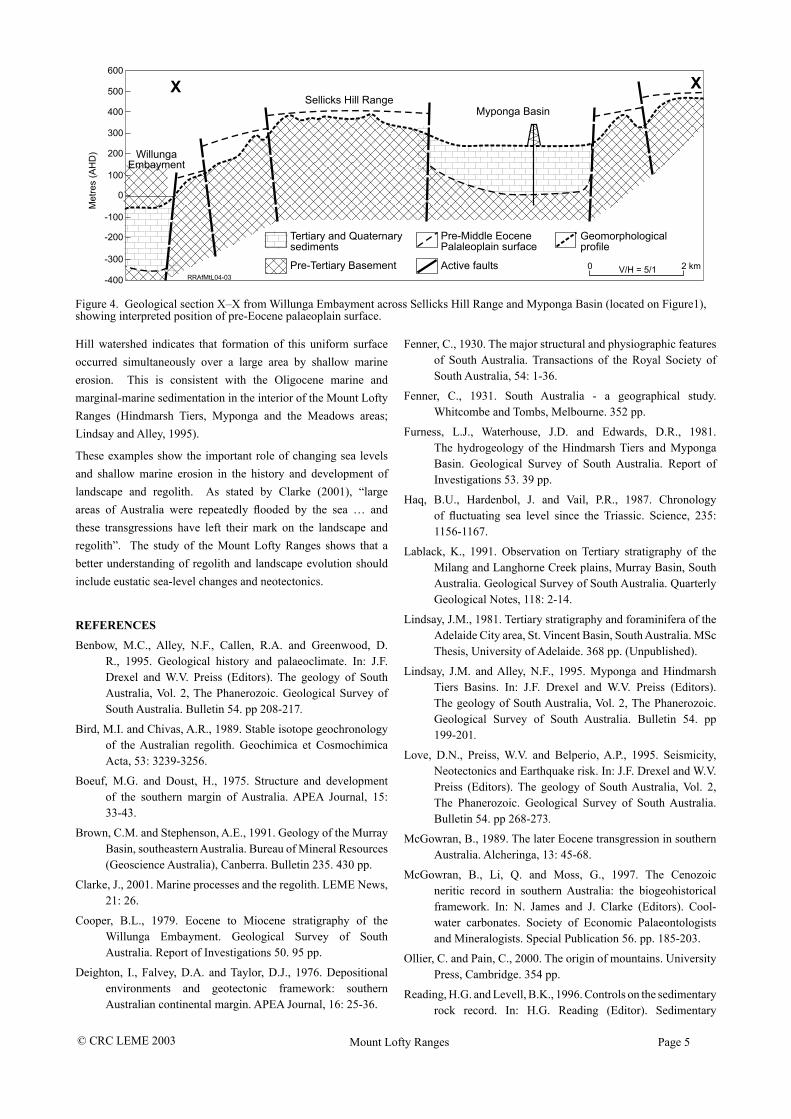
The thin regolith cover in the southwestern Mount Lofty Ranges and Fleurieu Peninsula contrasts with a thick regolith (tens of metres) in the north-eastern portion of the Ranges surrounding the watershed. A thin regolith on the Sellicks Hill Range (separating the Myponga and Willunga Basins) and on the watersheds of the lower Fleurieu Peninsula suggests that the deep regolith was stripped off these areas (Figure 4). This explains the post-Late Tertiary age of the regolith on the summit surface of the Fleurieu Peninsula as indicated by the oxygen isotope dating (Bird and Chivas, 1989). The flat character of the Sellicks
© CRC LEME 2003 Mount Lofty Ranges Page 5
Figure 4. Geological section X–X from Willunga Embayment across Sellicks Hill Range and Myponga Basin (located on Figure1), showing interpreted position of pre-Eocene palaeoplain surface.
Hill watershed indicates that formation of this uniform surface occurred simultaneously over a large area by shallow marine erosion. This is consistent with the Oligocene marine and marginal-marine sedimentation in the interior of the Mount Lofty Ranges (Hindmarsh Tiers, Myponga and the Meadows areas; Lindsay and Alley, 1995).
These examples show the important role of changing sea levels and shallow marine erosion in the history and development of landscape and regolith. As stated by Clarke (2001), “large areas of Australia were repeatedly flooded by the sea … and these transgressions have left their mark on the landscape and regolith”. The study of the Mount Lofty Ranges shows that a better understanding of regolith and landscape evolution should include eustatic sea-level changes and neotectonics.
REFERENCES
Benbow, M.C., Alley, N.F., Callen, R.A. and Greenwood, D. R., 1995. Geological history and palaeoclimate. In: J.F. Drexel and W.V. Preiss (Editors). The geology of South Australia, Vol. 2, The Phanerozoic. Geological Survey of South Australia. Bulletin 54. pp 208-217.
Bird, M.I. and Chivas, A.R., 1989. Stable isotope geochronology of the Australian regolith. Geochimica et Cosmochimica Acta, 53: 3239-3256.
Boeuf, M.G. and Doust, H., 1975. Structure and development of the southern margin of Australia. APEA Journal, 15: 33-43.
Brown, C.M. and Stephenson, A.E., 1991. Geology of the Murray Basin, southeastern Australia. Bureau of Mineral Resources (Geoscience Australia), Canberra. Bulletin 235. 430 pp.
Clarke, J., 2001. Marine processes and the regolith. LEME News, 21: 26.
Cooper, B.L., 1979. Eocene to Miocene stratigraphy of the Willunga Embayment. Geological Survey of South Australia. Report of Investigations 50. 95 pp.
Deighton, I., Falvey, D.A. and Taylor, D.J., 1976. Depositional environments and geotectonic framework: southern Australian continental margin. APEA Journal, 16: 25-36.
Fenner, C., 1930. The major structural and physiographic features of South Australia. Transactions of the Royal Society of South Australia, 54: 1-36.
Fenner, C., 1931. South Australia - a geographical study. Whitcombe and Tombs, Melbourne. 352 pp.
Furness, L.J., Waterhouse, J.D. and Edwards, D.R., 1981. The hydrogeology of the Hindmarsh Tiers and Myponga Basin. Geological Survey of South Australia. Report of Investigations 53. 39 pp.
Haq, B.U., Hardenbol, J. and Vail, P.R., 1987. Chronology of fluctuating sea level since the Triassic. Science, 235: 1156-1167.
Lablack, K., 1991. Observation on Tertiary stratigraphy of the Milang and Langhorne Creek plains, Murray Basin, South Australia. Geological Survey of South Australia. Quarterly Geological Notes, 118: 2-14.
Lindsay, J.M., 1981. Tertiary stratigraphy and foraminifera of the Adelaide City area, St. Vincent Basin, South Australia. MSc Thesis, University of Adelaide. 368 pp. (Unpublished).
Lindsay, J.M. and Alley, N.F., 1995. Myponga and Hindmarsh Tiers Basins. In: J.F. Drexel and W.V. Preiss (Editors). The geology of South Australia, Vol. 2, The Phanerozoic. Geological Survey of South Australia. Bulletin 54. pp 199-201.
Love, D.N., Preiss, W.V. and Belperio, A.P., 1995. Seismicity, Neotectonics and Earthquake risk. In: J.F. Drexel and W.V. Preiss (Editors). The geology of South Australia, Vol. 2, The Phanerozoic. Geological Survey of South Australia. Bulletin 54. pp 268-273.
McGowran, B., 1989. The later Eocene transgression in southern Australia. Alcheringa, 13: 45-68.
McGowran, B., Li, Q. and Moss, G., 1997. The Cenozoic neritic record in southern Australia: the biogeohistorical framework. In: N. James and J. Clarke (Editors). Cool-water carbonates. Society of Economic Palaeontologists and Mineralogists. Special Publication 56. pp. 185-203.
Ollier, C. and Pain, C., 2000. The origin of mountains. University Press, Cambridge. 354 pp.
Reading, H.G. and Levell, B.K., 1996. Controls on the sedimentary rock record. In: H.G. Reading (Editor). Sedimentary
© CRC LEME 2003 Mount Lofty Ranges Page 6
environments: processes, facies and Stratigraphy (3rd edition). University Press, Cambridge. 688 pp.
Sprigg, R.C., 1945. Some aspects of the geomorphology of portion of the Mt. Lofty Ranges. Royal Society of south Australia Transactions, 69: 277-302.
Stuart, W.J., 1969. Stratigraphic and structural development of the St. Vincent Basin, South Australia. PhD Thesis, University of Adelaide. 260 pp. (Unpublished).
Tokarev, V., Sandiford, M., Gostin, V., 1999. Landscape evolution in the Mount Lofty Ranges: implication for regolith development. In: G. Taylor and C. Pain (Editors). Proceedings of Regolith ’98, New Approaches to an Old Continent. CRC LEME, Perth, Australia. pp 127-134.
Twidale, C.R. and Bourne, J.A., 1975. Geomorphological evolution of part of the eastern Mt. Lofty Ranges, South Australia. Royal Society of South Australia Transactions, 99: 197-209.