
Mosman Local Environmental Plan 1998 · services provided, (f) to enhance and protect the scenic...
88
MOSMAN LOCAL ENVIRONMENTAL PLAN 1998 Mosman Municipal Council Amended - 12 December 2008 Mosman Local Environmental Plan 1998 under the Environmental Planning and Assessment Act 1979 I, the Minister for Urban Affairs and Planning, make the following local environmental plan under the Environmental Planning and Assessment Act 1979. (S94/00827/PC) CRAIG KNOWLES MP Minister for Urban Affairs and Planning Sydney 18 December 1998 DISCLAIMER This reprinted version of Mosman Local Environmental Plan 1998 is not a legal document. Reference should be made to the notice published in Government Gazette No. 178, 24 December 1998. Amended by: Mosman Local Environmental Plan 1998 (Amendment No.1) - Heritage Conservation, GG No. 41, 23 February 2001. Mosman Local Environmental Plan 1998 (Amendment No. 2) - Exempt and Complying Development, GG No. 126, 5 November 1999. Mosman Local Environmental Plan 1998 (Amendment No. 3) - GG No. 29, 25 February 2000. Mosman Local Environmental Plan 1998 (Amendment No. 5) - Queenwood Sites, GG No. 88, 14 July 2000. Mosman Local Environmental Plan 1998 (Amendment No. 6) - Wolger Road, GG No. 143, 3 November 2000. Mosman Local Environmental Plan 1998 (Amendment No. 7) - in respect of land at 3 Ellamatta Avenue, GG No.86, 18 May 2001 Mosman Local Environmental Plan 1998 (Amendment No. 8) - in respect of all land zoned 7(a) Environment Protection (Bushland) and the unformed portion of Stanton Road, GG No. 48, 22 February 2002. Mosman Local Environmental Plan 1998 (Amendment No. 9) - Acid Sulfate Soils & Wetlands, GG No. 119, 19 July 2002. Mosman Local Environmental Plan 1998 (Amendment No. 11) - Mapping Anomalies, GG No. 146, 28 September 2001.
Transcript of Mosman Local Environmental Plan 1998 · services provided, (f) to enhance and protect the scenic...

MOSMAN LOCAL ENVIRONMENTAL PLAN 1998
Mosman Municipal Council Amended - 12 December 2008
Mosman Local Environmental Plan 1998 under the Environmental Planning and Assessment Act 1979 I, the Minister for Urban Affairs and Planning, make the following local environmental plan under the Environmental Planning and Assessment Act 1979. (S94/00827/PC) CRAIG KNOWLES MP Minister for Urban Affairs and Planning Sydney 18 December 1998 DISCLAIMER This reprinted version of Mosman Local Environmental Plan 1998 is not a legal document. Reference should be made to the notice published in Government Gazette No. 178, 24 December 1998. Amended by: Mosman Local Environmental Plan 1998 (Amendment No.1) - Heritage Conservation, GG No. 41, 23 February 2001. Mosman Local Environmental Plan 1998 (Amendment No. 2) - Exempt and Complying Development, GG No. 126, 5 November 1999. Mosman Local Environmental Plan 1998 (Amendment No. 3) - GG No. 29, 25 February 2000. Mosman Local Environmental Plan 1998 (Amendment No. 5) - Queenwood Sites, GG No. 88, 14 July 2000. Mosman Local Environmental Plan 1998 (Amendment No. 6) - Wolger Road, GG No. 143, 3 November 2000. Mosman Local Environmental Plan 1998 (Amendment No. 7) - in respect of land at 3 Ellamatta Avenue, GG No.86, 18 May 2001 Mosman Local Environmental Plan 1998 (Amendment No. 8) - in respect of all land zoned 7(a) Environment Protection (Bushland) and the unformed portion of Stanton Road, GG No. 48, 22 February 2002. Mosman Local Environmental Plan 1998 (Amendment No. 9) - Acid Sulfate Soils & Wetlands, GG No. 119, 19 July 2002. Mosman Local Environmental Plan 1998 (Amendment No. 11) - Mapping Anomalies, GG No. 146, 28 September 2001.

MOSMAN LOCAL ENVIRONMENTAL PLAN 1998
Mosman Municipal Council Amended - 12 December 2008
Mosman Local Environmental Plan 1998 (Amendment No. 14) - Heritage Items, GG No. 154, 27 September 2002 Mosman Local Environmental Plan 1998 (Amendment No. 16) - Exempt and Complying Development, GG No. 170, 3 September 2002. Mosman Local Environmental Plan 1998 (Amendment No. 4) - Mosman Bowling Club site, GG No. 25, 24 January 2003 Mosman Local Environmental Plan 1998 (Amendment No. 15) - 3 Windward Avenue, GG No. 33, 31 January 2003 Mosman Local Environmental Plan 1998 (Amendment No. 12) - Foreshore Building Line, GG No. 168, 24 October 2003 Mosman Local Environmental Plan 1998 (Amendment No. 19) - Raglan Street, GG No. 179, 14 November 2003 Mosman Local Environmental Plan 1998 (Amendment No. 20) - Clause 14, GG No. 51, 5 March 200432 Mosman Local Environmental Plan 1998 (Amendment No. 18) - 647 & 653 Military Road, GG No. 49, 22 April 2005 Mosman Local Environmental Plan 1998 (Amendment No. 21) - Miscellaneous, GG No. 102, 12 August 2005 Mosman Local Environmental Plan 1998 (Amendment No. 22) - Child care centres, GG No. 40, 31 March 2006 Mosman Local Environmental Plan 1998 (Amendment No. 23) - Warringah Bowling Club site, GG No. 175, 8 December 2006 Mosman Local Environmental Plan 1998 (Amendment No. 24) - Exempt and Complying Development, GG No. 180, 7 December 2007 State Environmental Planning Policy (Repeal of Concurrence and Referral Provisions) 2008, GG No. 157, 12 December 2008

MOSMAN LOCAL ENVIRONMENTAL PLAN 1998
Mosman Municipal Council 1
Amended 12 December 2008
Contents
Part 1 Preliminary..............................................................................................................................3 1 What is this plan called?....................................................................................................... 3 2 What are the objectives of this plan?.................................................................................... 3 3 Where does this plan apply? ................................................................................................ 4 4 How does this plan affect other environmental planning instruments?................................. 4 5 How are terms defined in this plan? ..................................................................................... 4 6 Which model provisions does this plan adopt? .................................................................... 4 7 Who is the consent authority for this plan?........................................................................... 4 8 What special provisions apply to the temporary use of land?............................................... 4 9 How are trees preserved? .................................................................................................... 4 10 What savings provisions apply in this plan? ......................................................................... 5
Part 2 Residential zones...................................................................................................................7 11 What residential zones apply in this plan? ........................................................................... 7 12 What controls apply to subdivision in residential zones?.................................................... 10 13 Height limits in residential zones ........................................................................................ 10 14 Floorspace ratios in residential zones ................................................................................ 11 15 Landscaped area requirements in residential zones .......................................................... 12
Part 3 Business Zones................................................................................................................... 13 16 What business zones apply in this plan?............................................................................ 13 17 Floorspace ratios in business zones .................................................................................. 18 18 Height limits in business zones .......................................................................................... 19 19 What restrictions apply to drive-in take-away food shops?................................................. 19 20 Brothels .............................................................................................................................. 19
Part 4 Community Uses Zone....................................................................................................... 21 21 What community uses zone applies in this plan?............................................................... 21 22 Can schools be developed for community uses? ............................................................... 21 22A Queenwood Sites, Balmoral ............................................................................................... 22
Part 5 Open Space Zones.............................................................................................................. 23 23 What open space zones apply in this plan? ....................................................................... 23 24 What special considerations apply to development in open space zones? ........................ 25
Part 6 Environment Protection Zone ........................................................................................... 26 25 What environment protection zone applies in this plan? .................................................... 26
Part 7 National Parks Zone............................................................................................................ 27 26 What national parks zones apply in this plan? ................................................................... 27
Part 8 Environmental Controls ..................................................................................................... 29 27 Foreshore scenic protection area....................................................................................... 29 28 Foreshore building line ....................................................................................................... 29 29 Contaminated sites............................................................................................................. 30 30 Natural watercourses ......................................................................................................... 30 31 Excavation.......................................................................................................................... 31 31A Acid sulfate soils................................................................................................................. 31 31B Wetlands ............................................................................................................................ 32

MOSMAN LOCAL ENVIRONMENTAL PLAN 1998
Mosman Municipal Council
Amended 12 December 2008
Part 9 Heritage Conservation........................................................................................................ 34 32 Heritage conservation objectives ....................................................................................... 34 33 Protection of heritage items and heritage conservation areas............................................ 34 34 Deleted 35 Development of known or potential archaeological sites.................................................... 35 36 Original estate roads .......................................................................................................... 36 37 Development in the vicinity of heritage items ..................................................................... 36 38 Conservation incentives ..................................................................................................... 36 38A Significant interiors ............................................................................................................. 37 38B Taronga Zoo....................................................................................................................... 37
Part 10 Miscellaneous...................................................................................................................... 38 39 What public land is classified or reclassified as operational land? ..................................... 38 40 Exceptions.......................................................................................................................... 38 Schedules
Schedule 1 Definitions (Clause 5) ............................................................................ 39 Schedule 2 Heritage Items (Clauses 33 and 34 and Schedule 1) ............................ 48 Schedule 2A Heritage Conservation Areas (Schedule 1) ........................................... 70 Schedule 3 Archeological Sites (Schedule 1)........................................................... 71 Schedule 4 Original Estate Roads (Clause 36) ........................................................ 73 Schedule 4A Significant Interiors (Heritage Items Of State Significance Only)........... 74 Schedule 5 Classification And Reclassification Of Public Land (Clause 39) ............ 75 Schedule 6 Exceptions (Clause 40(1)) ..................................................................... 76 Schedule 7 Exceptions (Clause 40(3)) ..................................................................... 78 Schedule 8 Light Industries (Clause 16)................................................................... 79
Extract from the Model Provisions, 1980
Schedule 1 (to Clause 35)
Sydney Regional Environmental Plan No. 23 - Sydney and Middle Harbours: General Aims of the Plan

MOSMAN LOCAL ENVIRONMENTAL PLAN 1998
Mosman Municipal Council 3
Amended 12 December 2008
Part 1 Preliminary 1 What is this plan called? This plan is called Mosman Local Environmental Plan 1998. 2 What are the objectives of this plan? The objectives of this plan are the following: (a) to provide an easily understood planning document based on clear objectives which meet
community expectations, (b) to provide housing opportunities appropriate to environmental constraints while maintaining
the existing residential amenity, (c) to provide business opportunities for a range of uses, including residential, which encourage
local employment and economic growth, (d) to provide for a range of recreational and sporting opportunities to meet the needs of residents
of and visitors to Mosman, (e) to identify land required for community purposes to allow for the improvement of the range of
services provided, (f) to enhance and protect the scenic amenity of Sydney and Middle Harbours, (g) to retain views to and from water and foreshore reserves from and to public areas and streets
and residential allotments, (h) to protect and conserve the natural and built heritage of Mosman, (i) to manage change in a way that ensures an ecologically and economically sustainable urban
environment in which the needs and aspirations of the community are recognised, (j) to limit potential for additional traffic on the road system and to reduce car dependence
through development that supports public transport, cycling and walking, (k) to minimise the level of, with the aim of eliminating, pollution of all types, including air, land,
water, visual and noise pollution, which may result from development allowed by this plan, (l) to protect, conserve and enhance the landform and vegetation, especially foreshores or
bushland, in order to maintain the landscape amenity of Mosman, (m) to provide for the social, recreational and support needs of people with disabilities and the
needs of their carers, (n) to ensure that the housing needs of senior residents and residents with disabilities are met
with appropriate housing options, (o) to minimise and manage all waste generated in Mosman in accordance with the principles of
ecologically sustainable development, (p) to have regard to principles of ecologically sustainable development in assessing development
applications.
MOSMAN LOCAL ENVIRONMENTAL PLAN 1998
Mosman Municipal Council 4
Amended 12 December 2008
3 Where does this plan apply? (1) This plan applies to all land in Mosman as shown on the zoning map. (2) However, this plan does not apply to certain land at Middle Head and Georges Heights, shown
as ‘Deferred Matter’ on the zoning map, except for the provisions of Part 9 (Heritage conservation) and Schedules 1, 2, 3 and 4 to the extent that Part 9 applies to those Schedules.
4 How does this plan affect other environmental planning instruments? All local environmental plans applying to Mosman that were in force immediately before the commencement of this plan are repealed, except to the extent they apply to any land shown as ‘Deferred Matter’ on the zoning map. 5 How are terms defined in this plan? (1) Definitions of terms used in this plan are contained in Schedule 1. (2) Notes in this plan and the list of contents do not form part of this plan. 6 Which model provisions does this plan adopt? This plan adopts clauses 12, 19, 21, 22 and 31 of, and Schedule 1 to, the Environmental Planning and Assessment Model Provisions 1980. 7 Who is the consent authority for this plan? The Council is the consent authority for the purposes of this plan. 8 What special provisions apply to the temporary use of land? Regardless of any other provision of this plan, the Council may grant consent to any development, other than designated development, being carried out for a maximum period of 28 days, whether consecutive or non-consecutive, in any one year. 8A Application of plan to Markham Close, Middle Head (1) This plan applies to development within a Sydney Harbour Foreshore Site listed as Markham
Close, Middle Head in Sydney Harbour Federation Trust Management Plan – Mosman No 3 (Markham Close) (9 December 2003, and amended 28 February 2005).
(2) The development controls in that management plan apply to development on land identified as
Markham Close where there is an inconsistency with other controls in this plan or any Mosman development control plan.
9 How are trees preserved? (1) The Council, may, by resolution, make, revoke or amend a tree preservation order. (2) A tree preservation order may prohibit the ringbarking, cutting down, topping, lopping, pruning,
root pruning, removal, injury or wilfull destruction of any tree except with the consent of the Council.
Amendment 1 GG No. 41
Amendment 1 GG No. 41
Amendment 21 GG No. 102
MOSMAN LOCAL ENVIRONMENTAL PLAN 1998
Mosman Municipal Council 5
Amended 12 December 2008
(3) A tree preservation order and any revocation or amendment of such an order, does not have effect until it has been published in a newspaper circulating in the area of the Council.
(4) A person must not contravene a tree preservation order. (5) The tree preservation order applying to the land to which this plan applies immediately before
the commencement of this plan is taken to be a tree preservation order made and published in accordance with this clause.
10 What savings provisions apply in this plan? (1) Nothing in this plan restricts or prohibits, or enables the Council to restrict or prohibit: (a) the carrying out of development described in Schedule 1 to the Environmental Planning
and Assessment Model Provisions 1980, or (b) the use of existing buildings of the Crown by the Crown, or (c) home occupations carried on in dwelling houses. (2) Despite their repeal by clause 4 of this plan, local environmental plans applying to Mosman
that were in force immediately before the commencement of this plan continue to apply, as so in force, to development applications that were made but had not been finally determined before that commencement.
10A What is exempt and complying development?
(1) Development of minimal environmental impact listed as exempt development in
Mosman Development Control Plan – Exempt and Complying Development as adopted y the Council on 31 August 1999 and amended on 12 February 2002, 3 September 2002 and 2 October 2007 is exempt development, despite any other provision of this plan.
(2) Development listed as complying development in Mosman Development Control Plan –
Exempt and Complying Development as adopted by the Council on 31 August 1999 and amended on 12 February 2002, 3 September 2002 and 2 October 2007 is complying development if:
(a) it is local development of a kind that can be carried out with consent on the land
on which it is proposed, and
(b) it is not an existing use, as defined in section 106 of the Act. (3) Development is exempt or complying development only if it complies with the standards
and other requirements applied to the development by Mosman Development Control Plan - Exempt and Complying Development as adopted by the Council on 31 August 1999 and amended on 12 February 2002, 3 September 2002 and 2 October 2007.
(4) A complying development certificate issued for any complying development is subject to
the conditions for the development specified in Mosman Development Control Plan – Exempt and Complying Development adopted by the Council, as in force when the certificate is issued.
Amendment 2 GG No. 2 Amendment 9 GG No. 119
Amendment 2 GG No. 126
Amendment 16 GG No. 170
Amendment 16 GG No. 170
Amendment 16 GG No. 170
Amendment 24 GG No. 180
Amendment 24 GG No. 180
Amendment 24 GG No. 180

MOSMAN LOCAL ENVIRONMENTAL PLAN 1998
Mosman Municipal Council 6
Amended 12 December 2008
10B What general provisions apply to advertisements?
Despite any other provision of this plan, development may be carried out with consent on any land for the purpose of an advertisement if the Council is satisfied that:
(a) the advertisement only indicates the purpose for which the premises or site on which the
advertisement is located is used, and (b) the advertisement will not interfere with the amenity of the area.

MOSMAN LOCAL ENVIRONMENTAL PLAN 1998
Mosman Municipal Council 7
Amended 12 December 2008
Part 2 Residential zones 11 What residential zones apply in this plan? (1) The following residential zones apply as identified on the zoning map:
2 (a1) Residential 2 (a2) Residential 2 (a3) Residential 2 (b) Residential 2 (c) Residential 2 (d) Residential 2 (e) Residential
(2) The following development control tables outline the objectives of residential zones and
specify what development may be carried out without development consent, or only with development consent, and what development is prohibited, in each residential zone.
Amendment 2 GG No. 126

MOSMAN LOCAL ENVIRONMENTAL PLAN 1998
Mosman Municipal Council 8
Amended 12 December 2008
Development Control Table
2 (a1) Residential, 2 (a2) Residential and 2 (a3) Residential Zones
Retain the single dwelling character of the environmentally sensitive residential areas of Mosman
Maintain the general dominance of landscape over built form, particularly on harbour foreshores
Maintain the existing subdivision pattern
Ensure that sites are of sufficient size to provide for buildings, vehicular and pedestrian access, landscaping and retention of natural topographical features
Ensure that development is of a height and scale which complements existing buildings and streetscapes
Allow for some non-residential uses that would not adversely affect the living environment of the area
Encourage residential development which has regard to local amenity and, in particular, public and private views
1 Objectives of zones
Maintain the natural character of the harbour foreshore by ensuring that landscape dominates over built form.
2 Development allowed without development consent
Exempt development
3 Development allowed only with development consent
Demolition
Development for the purpose of: bed and breakfast establishments child care centres (allowed in the 2 (a1) Residential and 2 (a3) Residential zones only) drainage dwelling houses home businesses open space places of public worship roads semi-detached dwellings utility installations (other than gas holders or generating works)
Subdivision
4 Development which is prohibited Development not included in item 2 or 3
Amendment 12 GG No. 168
Amendment 22 GG No. 40

MOSMAN LOCAL ENVIRONMENTAL PLAN 1998
Mosman Municipal Council 9
Amended 12 December 2008
Development Control Table
2 (b) Residential, 2 (c) Residential, 2 (d) and 2 (e) Residential Zones
Ensure a variety of housing types in Mosman
Maintain and enhance landscaping as a major element in the residential environment
Provide for housing which is compatible with surrounding development in terms of bulk, height and scale
Allow for some non-residential uses that would not adversely affect the living environment of the area
Provide for some flexibility in development standards in the 2 (e) Residential zone to provide more housing opportunities
Ensure that development includes adaptable and accessible housing
1 Objectives of zones
Encourage residential development which has regard to local amenity and, in particular, public and private views
2 Development allowed without development consent
Exempt development
3 Development allowed only with development consent
Demolition
Development for the purpose of: bed and breakfast establishments boarding houses child care centres drainage dwelling houses educational establishments home businesses multiple dwellings open space places of public worship roads semi-detached dwellings utility installations (other than gas holders or generating works)
Subdivision
4 Development which is prohibited Development not included in item 2 or 3

MOSMAN LOCAL ENVIRONMENTAL PLAN 1998
Mosman Municipal Council 10
Amended 12 December 2008
12 What controls apply to subdivision in residential zones? (1) The objectives of this clause are:
(a) to retain the pattern of subdivision in residential areas while allowing infill development of smaller lots in some localities, and
(b) to ensure lots have a minimum size which would be sufficient to provide useable area
for building and landscaping, and
(c) to require larger lots along the foreshore or where the topography or other natural features of a site limit its subdivision potential, and
(d) to provide small lot subdivision in some zones as an alternative to redevelopment for the
purpose of multiple dwellings to ensure the retention of the existing dwelling stock and the amenity of the area.
(2) A lot resulting from a subdivision of land in a residential zone for the purpose of dwellings and
a lot on which a dwelling house or semi-detached dwelling is erected in a residential zone must comply with the requirements of the Table to this subclause.
Table
Zone Minimum Lot Size
2(a1) Residential 700 m2
2(a2) Residential 930 m2
2(a3) Residential 450 m2 (except for erection of a semi-detached dwelling) 230 m2 (for erection of a semi-detached dwelling
2(b), 2(c), 2(d), 2(e) Residential 300 m2 for erection of a dwelling house or semi-detached dwelling 700 m2 for erection of all other residential buildings
(3) For the purpose of subdivision access handles shall not be included in the calculation of site
area. (4) An allotment created by a subdivision pursuant to Part 3 of State Environmental Planning
Policy No 25 - Residential Allotment Sizes and Dual Occupancy Subdivision or clause 14C of Mosman Local Environmental Plan No 1 must not be further subdivided to create a separate land title for a dwelling.
13 Height limits in residential zones (1) The objectives of this clause are: (a) to protect public and private views, and (b) to minimise the visual impact of buildings when viewed from the harbour and
surrounding foreshores, and (c) to ensure buildings resulting from new development are compatible with existing
buildings in terms of height and pitched roof form, and
(d) to minimise the effects of bulk and scale of buildings arising from new development in existing residential areas.
Amendment 11 GG No. 146

MOSMAN LOCAL ENVIRONMENTAL PLAN 1998
Mosman Municipal Council 11
Amended 12 December 2008
(2) A building must comply with the requirements of the Table to this subclause. Table
Zone Maximum building height Maximum wall height
2(a1), 2(a2), 2(a3), 2(b), 2(c), 2(d) Residential
8.5 metres 7.2 metres
2(e) Residential 11 metres N/A
(3) A maximum of two storeys applies to all residential zones except the 2 (e) Residential zone.
However, the Council may allow an additional storey: (a) in attic roof space of existing and new buildings, or (b) in the existing basement of existing buildings, provided that in either case they do not add to bulk or building height. 14 Floorspace ratios in residential zones (1) The objectives of this clause are: (a) to control the scale of development so that it is compatible with housing characteristics
of the locality, and (b) to limit excavation of sites and retain natural ground levels for the purpose of
landscaping and containing urban run-off, and (c) to minimise the effects of bulk and scale of new development. (2) A building must not exceed the floorspace ratio indicated in the Table to this subclause. Table
Zone Maximum floorspace ratio
2(a1), 2(a2), 2(a3) Residential 0.5:1 for that part of the site area 700 m2 and 0.4:1 for that part of the site area > 700 m2
2(b) Residential 0.55:1
2(c) Residential 0.6:1
2(d) Residential 0.7:1
2(e) Residential 1:1
(3) Despite subclause (2), the Council may consent to development that results in a higher
floorspace ratio for buildings on land zoned 2 (e) Residential than the maximum allowed by that subclause if: (a) lot consolidation has resulted in a site area greater than or equal to 2000 m2, and (b) access other than from Spit or Military Roads can be provided to the site, and
Amendment 20 GG No. 51

MOSMAN LOCAL ENVIRONMENTAL PLAN 1998
Mosman Municipal Council 12
Amended 12 December 2008
(c) the Council is satisfied that the extra floorspace resulting will not have a detrimental
impact on the amenity of the neighbourhood. 15 Landscaped area requirements in residential zones (1) The objectives of this clause are: (a) to maintain and enhance the landscape and townscape character of Mosman’s
residential areas by requiring landscaping of sites in conjunction with other development, and
(b) to maintain a general dominance of landscape over buildings, particularly on harbour
foreshores and in the 2 (a1) and 2 (a2) Residential zones, and (c) to maintain and enhance significant vegetation, especially mature trees, and (d) to maintain natural ground levels, especially near boundaries, and to limit excavation of
sites, and (e) to ensure there is adequate and useable ground level open space for recreation,
landscaping and containing urban run-off. (2) The Council may refuse development consent to development involving the erection of a
building in a residential zone unless at least the minimum landscaped area as specified in the Table to this subclause is provided.
Development resulting in one dwelling per lot or a non-residential building
Site Area Minimum landscaped area as a percentage of gross floor area
< 500 m2 60%
500 m2 or more (Site area in square metres x 0.125)%
Development resulting in more than one dwelling per lot
Zone Minimum percentage of site to be landscaped
2(b) Residential 50%
2(c) Residential 50%
2(d) Residential 40%
2(e) Residential 40%
Amendment 2 GG No. 126

MOSMAN LOCAL ENVIRONMENTAL PLAN 1998
Mosman Municipal Council 13
Amended 12 December 2008
Part 3 Business Zones 16 What business zones apply in this plan? (1) The following business zones apply as identified on the zoning map:
3 (a1) Spit Junction Town Centre 3 (a2) Cremorne Business 3 (a3) Mosman Junction Town Centre 3 (b) Commercial/Residential 3 (c) Local Business 3 (d) The Spit Waterside Business
(2) The following development control tables outline the objectives of business zones and specify
what development may be carried out without development consent, or only with development consent, and what development is prohibited, in each business zone.
Amendment 2 GG No. 126

MOSMAN LOCAL ENVIRONMENTAL PLAN 1998
Mosman Municipal Council 14
Amended 12 December 2008
Development Control Table
3(a1) Spit Junction Town Centre Zone
3(a2) Cremorne Business Zone
3(a3) Mosman Junction Town
Centre Zone
Encourage office development in order to increase employment opportunities on public transport routes
Allow a diverse range of retail, commercial and entertainment opportunities as part of Cremorne Junction Centre
Maintain shopfronts at street level with a predominance of retail use in the centre
Allow a range of retail, business and entertainment opportunities which meet the needs and expectations of the local community and enhance the viability and vitality of the centre
Encourage residential development as part of the use of sites within the zone
Maintain and enhance the heritage streetscape
Encourage redevelopment for business purposes on sites outside the heritage conservation area
Improve, by civic design and landscape proposals, the amenity of this business zone
Maintain Military Road streetscape by allowing buildings of two storeys in height
1 Objectives of zones
Improve pedestrian and functional links between Bridgepoint and businesses on Spit and Military Roads
Ensure that development has regard to the relevant objectives and controls in the adjoining North Sydney area
Allow residential development as part of the use of sites at Mosman Junction
Encourage residential development as part of the use of sites at Spit Junction
Allow a range of light industrial type uses which meet the needs of the local community and would not adversely affect the amenity of the area
Encourage reinstatement of facades on altered buildings to match height and features of the heritage conservation area

MOSMAN LOCAL ENVIRONMENTAL PLAN 1998
Mosman Municipal Council 15
Amended 12 December 2008
3(a1) Spit Junction Town Centre Zone
3(a2) Cremorne Business Zone
3(a3) Mosman Junction Town
Centre Zone
Buildings to be of a height, bulk and form that is compatible and complementary to the existing streetscape
Allow a limited range of light industrial type uses which meet the needs of the local community and would not adversely affect the amenity of the area
Allow a limited range of light industrial type uses which meet the needs of the local community and would not adversely affect the amenity of the area
2 Development allowed without development consent
Exempt development
3 Development allowed only with development consent
Demolition Development for the purpose of: advertisements boarding houses brothels car repair stations carparking facilities child care centres clubs commercial premises community centres drainage dwelling houses educational establishments home businesses hospitals hotels light industries in Schedule 8 motels motor showrooms multiple dwellings open space places of assembly places of public worship public utility undertakings recreation facilities restaurants roads semi-detached buildings

MOSMAN LOCAL ENVIRONMENTAL PLAN 1998
Mosman Municipal Council 16
Amended 12 December 2008
3(a1) Spit Junction Town Centre Zone
3(a2) Cremorne Business Zone
3(a3) Mosman Junction Town
Centre Zone
service stations shops utility installations subdivision
4 Development which is prohibited
Development not included in item 2 or 3
Development Control Table
3 (b) Commercial/Residential Zone
1 Objectives of zones Encourage redevelopment for mixed residential/business uses which do not include shops
Ensure that the retail strip along Military Road is not extended
Ensure a reasonable level of residential amenity within sites in terms of noise, air quality and outdoor landscaped open space
2 Development allowed without development consent
Exempt development
3 Development allowed only with development consent
Demolition
Development for the purpose of: advertisements boarding houses child care centres commercial premises community centres drainage dwelling houses educational establishments home businesses multiple dwellings open space places of assembly places of public worship public utility undertakings recreation facilities roads semi-detached dwellings utility installations
Subdivision
4 Development which is prohibited Development not included in item 2 or 3

MOSMAN LOCAL ENVIRONMENTAL PLAN 1998
Mosman Municipal Council 17
Amended 12 December 2008
Development Control Table
3 (c) Local Business Zone
1 Objectives of zones Allow business and services which primarily meet the day to day needs of the local community
Allow residential development as part of the use of sites in local business areas
Maintain shop uses on street level
Minimise the effect of business development on adjacent residential areas, having regard to the carparking capacity of the roads in those areas
Allow buildings of two storeys in height
2 Development allowed without development consent
Exempt development
3 Development allowed only with development consent
Demolition
Development for the purpose of: advertisements boarding houses child care centres commercial premises community centres drainage dwelling houses educational establishments home businesses light industries in Schedule 8 multiple dwellings open space places of assembly places of public worship public utility undertakings recreation facilities restaurants roads semi-detached dwellings service stations shops utility installations
Subdivision
4 Development which is prohibited Development not included in item 2 or 3

MOSMAN LOCAL ENVIRONMENTAL PLAN 1998
Mosman Municipal Council 18
Amended 12 December 2008
Development Control Table 3 (d) The Spit Waterside Business Zone
1 Objectives of zones Maintain The Spit as a prime recreational boating resource and working marine area with associated commercial activities
Allow development which is unlikely to generate additional traffic and demand for additional parking
Maintain and improve the scenic quality of The Spit by ensuring the external appearance of buildings is of suitable materials and colours and of a height and scale which is unlikely to affect the environment adversely
2 Development allowed without development consent
Exempt development
3 Development allowed only with development consent
Demolition
Development for the purpose of: boating industry facilities carparking facilities coastal patrol administration and operations drainage marinas marine sales and service centres open space restaurants roads utility installations (other than gas holders or generating works)
Water based clubs and activities
4 Development which is prohibited Development not included in item 2 or 3
17 Floorspace ratios in business zones
(1) The objective of this clause is to control the bulk and site coverage of buildings so that buildings resulting from new development are compatible with existing buildings.
(2) Floorspace ratios in business zones must not exceed the floorspace ratios in the Table to this subclause.

MOSMAN LOCAL ENVIRONMENTAL PLAN 1998
Mosman Municipal Council 19
Amended 12 December 2008
Table
Zone Maximum floorspace ratio
3 (a1) Spit Junction Town Centre 2:1
3(a2) Cremorne Business 2:1
3(a3) Mosman Junction Town Centre 2:1
3(b) Commercial/Residential 2:1
3(c) Local Business 1.3:1
3(d) The Spit Waterside Business 1:1
18 Height limits in business zones (1) The objectives of this clause are:
(a) to ensure that buildings resulting from new development are compatible with existing buildings in terms of height and roof form to produce a cohesive streetscape, and
(b) to provide opportunities for higher buildings in suitable locations to achieve the Council’s
residential strategy and provide employment opportunities. (2) Generally, building heights in business zones are to complement the heights of adjacent
buildings, except in the following zones:
(a) the 3 (b) Commercial/Residential zone, in which a building may be up to 12 metres high, regardless of the height of the adjacent buildings, and
(b) the 3 (d) The Spit Waterside Business zone, in which a building may be up to 8 metres
high, regardless of the height of the adjacent buildings. (3) Buildings within the 3 (a3) Mosman Junction Town Centre zone are generally to be no higher
than two storeys on the Military Road and Middle Head Road frontages. 19 What restrictions apply to drive-in take-away food shops? The Council must not consent to development for the purpose of a drive-in take-away food shop on land within any business zone if the land concerned has frontage to: (a) that part of Spit Road between The Spit and Military Road, or (b) Military Road. 20 Brothels (1) When assessing an application for consent to the use of premises for the purpose of a brothel,
the Council must consider the following:
(a) the distance between the premises and any place of worship, school, community facility, residential development, hospital or medical centre or any place in the vicinity of the premises regularly frequented by children for any reason,
(b) whether the operation of the brothel could cause a disturbance in the neighbourhood,
taking into account the location of any other brothels operating in the neighbourhood,
Amendment 21 GG No. 102

MOSMAN LOCAL ENVIRONMENTAL PLAN 1998
Mosman Municipal Council 20
Amended 12 December 2008
(c) whether sufficient off-street parking will be provided, (d) whether the brothel will be accessed by a separate entrance, (e) whether the operation of the brothel would interfere with the amenity of the
neighbourhood because of its size, operating hours, traffic generation, lighting or noise or the number of its employees and clients,
(f) whether the operations of the brothel will utilise circulation areas common to any other
use of the premises.
(2) Development for the purpose of a brothel is prohibited on land to which this plan applies if the brothel is located at ground level within a business zone.
(3) Development for the purpose of a brothel is prohibited on land to which this plan applies in any part of premises on an allotment within a business zone if any part of the allotment is used for residential purposes.

MOSMAN LOCAL ENVIRONMENTAL PLAN 1998
Mosman Municipal Council 21
Amended 12 December 2008
Part 4 Community Uses Zone 21 What community uses zone applies in this plan? (1) The following community uses zone applies as identified on the zoning map:
5 (a) Community Uses
(2) The following development control table outlines the objectives of the community uses zone
and specifies what development may be carried out without development consent, or only with development consent, and what development is prohibited, in the zone.
Development Control Table
5(a) Community Uses Zone
1 Objectives of zones Identify land for the provision of community services and facilities
Allow land to be used for a limited range of community uses in addition to the specific land use for which it is zoned
Contribute to the scenic quality of Mosman and the harbour.
2 Development allowed without development consent
Exempt development
Structures solely for the purposes of exhibition, conservation and care of animals on land zoned Community Uses 5(a) – Zoo
3 Development allowed only with development consent
Demolition
Development for the purpose of: the particular land use indicated on the zoning map child care centres drainage open space recycling drop-off centres roads utility installations (other than gas holders or generating works)
Subdivision
4 Development which is prohibited Development not included in item 2 or 3
22 Can schools be developed for community uses? The Council may grant development consent for the community use of the facilities and sites of schools, colleges or other educational establishments and for the commercial operation of these facilities and sites.
Amendment 2 GG No. 126
Amendment 12 GG No. 168
MOSMAN LOCAL ENVIRONMENTAL PLAN 1998
Mosman Municipal Council 22
Amended 12 December 2008
22A Queenwood Sites, Balmoral
(1) This clause applies to land situated in the Mosman area, known as:
Nos. 47, 49 and 51 Mandolong Road and No. 21 Hunter Road, Mosman, being Lot 1 DP 71569 and Lots 48, 49, 52 and 53 DP 6314, lots 48, 52 and 53 being shown coloured yellow on the map marked “Mosman Local Environmental Plan 1998 (Amendment No. 5) (Map A)”; No. 44 Mandolong Road, being Lots 1,2, and 3 DP 307922 and Lots 6A and 6B DP 307704; Lots A, B, C, and D DP 349211, being land bounded by Raglan Street, The Esplanade and Esther Road, shown coloured yellow on the map marked “Mosman Local Environmental Plan (Amendment No. 5) (Map B)”.
(2) The Council shall not grant consent to development on land referred to in subclause (1) unless it is generally satisfied that the proposed development will meet the following objectives for that land: (a) to ensure that any new buildings are of a height, bulk and scale which complements
existing buildings and streetscapes within the neighbourhood; (b) to maintain the amenity of the neighbourhood in terms of solar access, privacy and
noise; (c) to ensure that development does not significantly obstruct views from surrounding
properties and public places and where possible to enhance existing views; (d) to encourage a high quality design for the school use within a residential setting; (e) to provide adequate off-street car parking to meet existing and future demand
generated by use of the land as a school; (f) to ensure adequate outdoor areas and separation between buildings on the land in
order to provide an appropriate scale of development; (g) to ensure consideration has been given to the Queenwood Development Control
Plan (as adopted by the Council on 28 March 2000). (3) When considering an application for development for consent to carry out a community
use, or for the purpose of a commercial operation of facilities and sites, on land referred to in subclause (1), the Council must have regard to the following: (a) evidence of specific locational need; (b) satisfactory access (including promotion and use of means other than the private car)
and parking arrangements; (c) the capacity of the locality or neighbourhood to absorb the proposed activity; (d) any likely adverse impacts on residential amenity.
Amendment 5 GG No 88

MOSMAN LOCAL ENVIRONMENTAL PLAN 1998
Mosman Municipal Council 23
Amended 12 December 2008
Part 5 Open Space Zones 23 What open space zones apply in this plan? (1) The following open space zones apply as identified on the zoning map:
6(a) Public Recreation 6(b) Private Recreation
(2) The following development control tables outline the objectives of open space zones and
specify what development may be carried out without development consent, or only with development consent, and what development is prohibited, in each zone.
Development Control Table
6(a) Public Recreation Zone
1 Objectives of zones Provide a viable open space system which supports a diversity of leisure and educational opportunities
Maintain and provide open space links to a diversity of public and private spaces and facilities as an integral part of the open space system
Ensure that open space is managed on a sustainable basis including the maintenance of ecological processes, genetic diversity and geo-diversity
Ensure conservation and proper management of cultural values within the open space system
Ensure that open space contributes to the aesthetic quality, experience and image of the community
2 Development allowed without development consent
Development for the purpose of park furniture (including seats, bins, picnic tables and similar items) and lighting (other than lighting to be used in connection with active recreation, such as sporting activities, or active recreation facilities)
Exempt development
Works for the purpose of gardening, landscaping and bushfire hazard reduction
Amendment 2 GG No.126

MOSMAN LOCAL ENVIRONMENTAL PLAN 1998
Mosman Municipal Council 24
Amended 12 December 2008
6(a) Public Recreation Zone
3 Development allowed only with development consent
Demolition
Development for the purpose of: beach and foreshore protection works buildings associated with landscaping, gardening or bushfire hazard reduction and vehicular access to those buildings carparking ancillary to another permissible use child care centres drainage kiosks recreation areas recreation facilities recreation, sporting and cultural activities roads utility installations
Subdivision
4 Development which is prohibited Development on reserved or dedicated Crown land that does not comply with the public purpose notified under the Crown Lands Act 1989 or does not comply with acceptable uses identified in an adopted Plan of Management for the reserve, under the Crown Lands Act 1989
Other development not included in item 2 or 3
Development Control Table
6(b) Private Recreation Zone
1 Objectives of zones Identify private land which is set aside for recreational purposes
2 Development allowed without development consent
Development for the purpose of landscaping and gardening
Exempt development
3 Development allowed only with development consent
Demolition
Development for the purpose of: carparking ancillary to another permissible use clubs recreation areas recreation facilities utility installations
Subdivision
4 Development which is prohibited Development not included in item 2 or 3

MOSMAN LOCAL ENVIRONMENTAL PLAN 1998
Mosman Municipal Council 25
Amended 12 December 2008
24 What special considerations apply to development in open space zones? In determining development applications relating to land in open space zones, the Council must consider the following: (a) the need for the proposed development, and (b) the impact of the proposed development on the existing or likely future use of the land, and (c) the need to retain the land for its existing or likely future use.

MOSMAN LOCAL ENVIRONMENTAL PLAN 1998
Mosman Municipal Council 26
Amended 12 December 2008
Part 6 Environment Protection Zone 25 What environment protection zone applies in this plan? (1) The following environment protection zone applies as identified on the zoning map:
7 (a) Environment Protection (Bushland)
(2) The following development control table outlines the objectives of the environment protection
zone and specifies what development may be carried out without development consent, or only with development consent, and what development is prohibited, in the zone.
Development Control Table
7(a) Environment Protection (Bushland) Zone
1 Objectives of zones Retain and manage bushland areas for their scenic and environmental values
Conserve native plant and animal species through the maintenance of suitable habitats
Contribute to the scenic quality of Mosman and the harbour
2 Development allowed without development consent
Development for the purpose of bushland regeneration or bushfire hazard reduction
Drainage works that are:
(a) carried out by or on behalf of the Council and involve the maintenance of existing drainage lines, or
(b) carried out by or on behalf of the Council and involve the installation of pollution control devices on so much of the land within the zone as is coloured brown and diagonally hatched on the map marked “Mosman Local Environmental Plan 1998 (Amendment No. 8)”
3 Development allowed only with development consent
Drainage works (other than drainage works referred to in item 2)
Works to enable pedestrian access to facilitate recreational use of the bushland
4 Development which is prohibited Development not included in item 2 or 3
Amendment 8 GG No. 48

MOSMAN LOCAL ENVIRONMENTAL PLAN 1998
Mosman Municipal Council 27
Amended 12 December 2008
Part 7 National Parks Zone 26 What national parks zones apply in this plan? (1) The following national parks zones apply as identified on the zoning map:
8 (a) National Parks 8 (b) National Parks (Proposed)
(2) The following development control tables outline the objectives of the national parks zones
and specify what development may be carried out without development consent, or only with development consent, and what development is prohibited, in each zone.
Development Control Table
8(a) National Parks Zone
1 Objectives of zones Identify land dedicated or reserved as a national park under the National Parks and Wildlife Act 1974
Conserve areas of natural ecological, scenic, educational, scientific, cultural or historical importance
2 Development allowed without development consent
Any development authorised by or under the National Parks and Wildlife Act 1974 and any development incidental or ancillary to that development
3 Development allowed only with development consent
Nil
4 Development which is prohibited Development not included in item 2

MOSMAN LOCAL ENVIRONMENTAL PLAN 1998
Mosman Municipal Council 28
Amended 12 December 2008
Development Control Table
8(b) National Parks (Proposed) Zone
1 Objectives of zones Identify land which is to be reserved or dedicated under the National Parks and Wildlife Act 1974
Protect the values of that land for the use for which it is proposed to be so reserved or dedicated
2 Development allowed without development consent
Nil
3 Development allowed only with development consent
Any development authorised by or under the National Parks and Wildlife Act 1974 and development incidental or ancillary to that development
4 Development which is prohibited Development not included in item 3
(3) Before determining an application for consent required by this clause, the Council must refer
the application to the Director-General of National Parks and Wildlife and consider any advice of the Director-General received within 28 working days after the referral.
MOSMAN LOCAL ENVIRONMENTAL PLAN 1998
Mosman Municipal Council 29
Amended 12 December 2008
Part 8 Environmental Controls 27 Foreshore scenic protection area (1) The objectives of establishing a foreshore scenic protection area are:
(a) to recognise, protect and enhance the natural, visual, environmental and heritage
qualities of Mosman, and (b) to co-ordinate planning controls with Sydney Regional Environmental Plan (Sydney
Harbour Catchment) 2005 and ensure its objectives are met.
(2) The Council must not consent to the alteration or erection of a building on land in the foreshore scenic protection area unless it has made an assessment, having regard to the objectives of Sydney Regional Environmental Plan (Sydney Harbour Catchment) 2005, the impact of the proposed development on the natural environment, the visual environment and the environmental heritage of Mosman.
(3) If, after having made the assessment, the Council considers that the proposed development impacts adversely on the natural environment, the visual environment or the environmental heritage of Mosman, the Council may refuse to consent to the proposed development.
(4) This clause does not affect any requirement of Sydney Regional Environmental Plan (Sydney Harbour Catchment) 2005.
28 Foreshore building line (1) The objectives of this clause are:
(a) to protect the natural landform and landscape of the foreshore, and (b) to contribute to a bushland and wildlife corridor around the foreshore of Mosman, and (c) to control pollution by limiting stormwater run-off directly into waterways by retaining and
protecting vegetation along the foreshore, and (d) to protect the visual amenity of the foreshore, and (e) to protect dwellings from potential rising sea levels resulting from the global warming. (f) to minimise the visual scale and bulk of development when viewed from the water, and (g) to protect the public views and the visual amenity of the foreshore when viewed from the
water by ensuring that native vegetation growth (trees, shrubs and groundcover species) along the foreshore is protected and enhanced, and
(h) to ensure that foreshore areas that are developed provide adequate areas for protecting
and enhancing local native vegetation growth (trees, shrubs and groundcover species). This native vegetation growth should protect adjacent waterways from runoff and contribute to a habitat corridor (including by providing shelter and organic matter) for both terrestrial and aquatic ecosystems.
Amendment 12 GG No. 168
Amendment 12 GG No. 168
Amendment 12 GG No. 168
Amendment 12 GG No. 168
Amendment 12 GG No. 168

MOSMAN LOCAL ENVIRONMENTAL PLAN 1998
Mosman Municipal Council 30
Amended 12 December 2008
(2) Except as provided by subclause (3), the Council must not consent to the erection of a building or the carrying out of a work on land between the foreshore building line and adjacent tidal waters.
(3) The Council may consent to:
(a) the erection of single storey boatsheds, wharves or jetties, or (b) the erection of a structure or the carrying out of a work, at or below the surface of the
ground, between a foreshore building line and adjacent tidal waters, but only if it has considered the probable aesthetic appearance of the proposed structure, or the result of the carrying out of the work, in relation to the foreshore.
29 Contaminated Sites (1) The objective of this clause is to require the remediation of contaminated sites to make them
safe before development takes place on the sites. (2) In determining whether to grant development consent in respect of land that is contaminated,
the Council must consider: (a) the need for testing and remediation and validation plans to make the land suitable for
the proposed use, and (b) the effect of proposed remediation on adjoining land, and (c) the need to restrict the range of land uses allowable if the land is assessed as being
suitable for a limited number of land uses only. (3) Nothing in this clause affects the application of State Environmental Planning Policy No 55 -
Remediation of Land to land to which this plan applies. 30 Natural watercourses (1) The objective of this clause is to protect natural watercourses and their role in disposing of
stormwater and controlling pollution and sedimentation, and to facilitate continuing biodiversity in a freshwater environment.
(2) In assessing an application for development consent relating to land in the vicinity of a natural
watercourse, the Council must consider: (a) whether the proposed development would affect the water quality or obstruct the natural
waterflow, and
(b) the likelihood of increased run-off from the proposed development leading to degradation or erosion of the natural watercourse, and
(c) whether flora and fauna habitats would be affected by the proposed development.
Amendment 12 GG No. 168

MOSMAN LOCAL ENVIRONMENTAL PLAN 1998
Mosman Municipal Council 31
Amended 12 December 2008
31 Excavation (1) The objective of this clause is to control soil erosion, sedimentation, tree loss and drainage
impacts associated with land form modification. (2) The consent of the Council is required to carry out works or any other development on land
which has the effect of materially altering the shape or natural form of the land. 31A Acid sulfate soils (1) The objectives of this clause are:
(a) to minimize disturbance to acid sulfate soils in Mosman so as to avoid any potential environmental hazard, and
(b) to require development consent for works that would disturb soils or ground water levels
in localities identified as having acid sulfate soils, and (c) to require the special assessment of certain development of land identified as being
subject to risks associated with the disturbance of acid sulfate soils. (2) A person must not, without the consent of the Council, carry out the following works on or
under land identified on the foreshore protection map: (a) as being within an acid sulfate soil area – works beyond 1 metre below the existing
ground surface or involving the disturbance of more than 1 tonne of soil (such as occurs in carrying out the construction or maintenance of drains, dredging, the construction of artificial waterbodies including detention basins, the construction of underground structures including basement carparks, the construction of foundations or flood mitigation works) or both, or
(b) as being within a buffer area – works involving excavation below 1m AHD, or (c) in relation to any land identified on the foreshore protection map – works that are likely
to lower the ground water table, regardless of how much soil is to be disturbed. (3) Despite sub-clause (2), development consent is not required for the carrying out of such works
if: (a) a copy of a preliminary assessment of the proposed works undertaken in accordance
with the Acid Sulfate Soils Assessment Guidelines has been given to the Council; and (b) the Council has provided written advice to the person proposing to carry out the works
confirming that the results of the preliminary assessment indicate that the proposed works need not be carried out pursuant to an acid sulfate soils management plan prepared in accordance with the Acid Sulfate Soils Assessment Guidelines.
(4) The Council must not grant a consent required by this clause unless the Council has
considered: (a) the adequacy of an acid sulfate soils management plan prepared for the proposed
development in accordance with the Acid Sulfate Soils Assessment Guidelines, and (b) the likelihood of the proposed development resulting in the discharge of acid water, and
Amendment 9 GG No. 119

MOSMAN LOCAL ENVIRONMENTAL PLAN 1998
Mosman Municipal Council 32
Amended 12 December 2008
(5) This clause requires consent for development to be carried out by a public authority, despite
clause 10 (1) (a). However, despite subclause (2) of this clause, consent is not required for a public authority to carry out development for the purposes of: (a) emergency work, or (b) routine maintenance, or (c) minor excavation work.
(6) Despite subclause (2), the following development may be carried out by the Council without
development consent: (a) the installation of stormwater quality improvement devices and drainage works, and (b) any work ancillary to that development, such as the construction of accessways, the
provision of power, water and sewerage supplies, and landscape works. (7) If the Council carries out work referred to in subclause (6) and is reasonably likely to encounter
acid sulfate soils in carrying out that work, the Council: (a) must conduct a preliminary assessment of the proposed works in accordance with the
Acid Sulfate Soils Assessment Guidelines so as to minimise the actual or potential impact to the environment arising from the disturbance of the soils, and
(b) must implement reasonable measures to minimise that impact.
31B Wetlands (1) The objectives of this clause are:
(a) to protect Mosman’s wetlands from inappropriate development by preventing or
regulating, or preventing and regulating, development that has the potential to fragment, pollute, disturb or diminish the value of the wetlands, and
(b) to protect, restore and maintain ecological processes, natural systems and biodiversity
within the wetlands, and (c) to improve, maintain and restore the quality of water within the wetlands and water
entering the wetlands so as to ensure that wetland values and natural ecological functions are not diminished.
(2) This clause applies to land within the Mosman local government area identified as “Wetlands”
or “Wetland buffer” on the map marked “Wetlands” drawn by SPH in May 2001. (3) The Council must not consent to the carrying out of works on land to which this clause applies
that have the potential to fragment, pollute, disturb or diminish wetland values, unless the Council: (a) has made an assessment of the predicted environmental impacts of the proposed works
and proposed measures for mitigation, and (b) has considered the relevant objectives and requirements of:
Amendment 9 GG No. 119

MOSMAN LOCAL ENVIRONMENTAL PLAN 1998
Mosman Municipal Council 33
Amended 12 December 2008
(i) Sydney Regional Environmental Plan No. 23 - Sydney and Middle Harbours:, and
(ii) any relevant policies and guidelines published from time to time by NSW
Fisheries. (4) If, after making an assessment, the Council considers the proposed development will have
either a direct or indirect adverse impact on land to which this clause applies identified as wetland areas or wetland buffer areas, the Council may refuse to consent to the proposed development.
(5) Despite subclauses (3) and (4), the following development may be carried out by the Council
without development consent: (a) the installation of stormwater quality improvement devices and drainage works, or (b) any work ancillary to that development, such as the carrying out of minor excavation
work, the construction of accessways, the provision of power, water and sewerage supplies, and landscape works.
(6) If the Council plans to carry out work referred to in subclause (5), the Council:
(a) must have regard to the predicted environmental impact of the work on land to which
this clause applies identified as wetland areas, and (b) must implement reasonable measures for mitigation of that impact, such as suitable
erosion and sediment controls. (7) The requirements imposed by this clause apply to development to be carried out by a public
authority, despite clause 10(1)(a). However, the requirements do not apply to a public authority carrying out development for the purposes of: (a) emergency work, or (b) routine maintenance, or (c) minor excavation work.

MOSMAN LOCAL ENVIRONMENTAL PLAN 1998
Mosman Municipal Council 34
Amended 12 December 2008
Part 9 Heritage Conservation 32 Heritage conservation objectives (1) The objectives of this Part are:
(a) to conserve the environmental heritage and cultural significance of the local
government area of Mosman, and (b) to ensure that any development does not adversely affect the heritage
significance of heritage items and heritage conservation areas and their settings, and
(c) to ensure that archaeological sites and places of Aboriginal significance are
conserved, and (d) to maintain traditional streetscapes in areas where older style houses
predominate, and (e) to encourage an appreciation of the heritage of the local government area of
Mosman. 33 Protection of heritage items and heritage conservation areas (1) The following development requires the Council’s consent:
(a) demolishing or moving a heritage item or a building, work, relic or place within a
heritage conservation area, (b) altering a heritage item or a building, work, relic or place within a heritage
conservation area by making structural or non-structural changes to its exterior including to the detail, fabric, finish or appearance,
(c) moving a relic, or excavating land for the purpose of discovering, exposing or
moving a relic, (d) erecting a building on, or subdividing, land on which a heritage item is located or
which is within a heritage conservation area. (2) The Council’s consent is not required if:
(a) the Council is of the opinion that the proposed development is of a minor nature
or consists of maintenance of an item or of a building, work, relic or place within a heritage conservation area, and
(b) the Council is satisfied that the proposed development would not adversely affect
the significance of the heritage item or heritage conservation area and, in the case of external alterations, would only have a minor visual impact when viewed from the street or any other public place and, in the case of maintenance work, is necessary for the ongoing protective care of the heritage item or the building, work or relic within the heritage conservation area.
Amendment 1 GG No. 41
Amendment 1 GG No. 41

MOSMAN LOCAL ENVIRONMENTAL PLAN 1998
Mosman Municipal Council 35
Amended 12 December 2008
(3) When determining a development application required by this clause, the Council: (a) must take into consideration the extent to which the carrying out of the proposed
development would affect the heritage significance of the heritage item or heritage conservation area, and
(b) must not grant consent until it has considered a statement of heritage impact that
identifies and assesses the impact of the proposal on the heritage significance of the item and its setting, or on the heritage conservation area, and
(c) may decline to grant consent to the application until it has considered a heritage
assessment to enable the Council to fully assess the levels of heritage significance of the item and its setting, or of the heritage conservation area, and
(d) must not grant consent to development involving heritage items classified in
Schedule 2 as being of State significance unless it has considered a conservation plan which sets out management constraints for development or unless it is of the opinion that the proposed development is of a minor nature.
Note: The website of the Heritage Branch of the Department of Planning has
publications that provide guidance on assessing the impact of proposed development on the heritage significance of items (for example, Statements of Heritage Impact).
34 Deleted 35 Development of known or potential archaeological sites (1) The Council may consent to the carrying out of development on an archaeological site
that has Aboriginal heritage significance (such as a site that is the location of an Aboriginal place or a relic, within the meaning of the National Parks and Wildlife Act 1974) or a potential archaeological site that is reasonably likely to have Aboriginal heritage significance, only if: (a) it has considered an assessment of how the proposed development would affect
the conservation of the site and any relic known or reasonably likely to be located at the site prepared in accordance with any guidelines for the time being notified to it by the Director-General of National Parks and Wildlife, and
(b) except where the proposed development is integrated development, it has notified
the local Aboroginal communities (in such a way as it thinks appropriate) of the development application and taken into consideration any comments received in response within 21 days after the notice was sent; and
(c) it is satisfied that any necessary consent or permission required under the
National Parks and Wildlife Act 1974 has been granted. (2) The Council may consent to the carrying out of development on an archaeological site
that has non-Aboriginal heritage significance or a potential archaeological site that is reasonably likely to have non-Aboriginal heritage significance only if: (a) it has considered an assessment of how the proposed development would affect
the conservation of the site and any relic known or reasonably likely to be located at the site prepared in accordance with any guidelines for the time being notified to it by the Heritage Council, and
Amendment 1 GG No. 41
Amendment 11 GG No. 146
SEPP 2008 GG No. 157
SEPP 2008 GG No. 157
SEPP 2008 GG No. 157

MOSMAN LOCAL ENVIRONMENTAL PLAN 1998
Mosman Municipal Council 36
Amended 12 December 2008
(b) it is satisfied that any necessary excavation permit required by the Heritage Act 1977 has been granted.
(3) Subclause (2) does not apply if the proposed development does not involve disturbance
of anything below ground level and the Council is of the opinion that the heritage significance of things at or above ground level would not be adversely affected by the proposed development.
36 Original estate roads Consent must not be granted for development that consists of or involves the realignment of an original estate road or historic road alignment described in Schedule 4 unless the consent authority has made an assessment of the effect of the realignment on the heritage significance of the road and its alignment. 37 Development in the vicinity of heritage items (1) The Council, when determining an application for consent to carry out development on
land in the vicinity of a heritage item, must consider:
(a) the likely effect of the proposed development on the heritage significance, curtilage and setting of the item, and
(b) the impact of the proposed development on any significant views to or from the
heritage item. (2) The Council may decline to grant the application until it has considered a statement of
heritage impact to assist it to assess the impact of the proposed development on the heritage item.
38 Conservation incentives (1) The Council may consent to the use, for any purpose, of a building that is a heritage item
or of the land on which any such building is erected (including its conversion to multiple dwellings), even though the use would otherwise be prohibited by this plan, if it is satisfied that: (a) the proposed use would not adversely affect the heritage significance of the item
or heritage conservation area, and (b) the conservation of the building depends on the granting of the consent, and (c) the amenity of the locality would not be adversely affected by the proposed use of
the building or land. (2) When considering an application for consent to erect a building on land on which a
heritage item is located, the Council may, for the purpose of determining: (a) the floorspace ratio, and (b) the number of parking spaces to be provided on the site, exclude the floorspace of the building from its calculation of the floorspace of the buildings erected on the land, but only if it is satisfied that:
Amendment 1 GG No. 41
Amendment 1 GG No. 41
Amendment 1 GG No. 41
SEPP 2008 GG No. 157

MOSMAN LOCAL ENVIRONMENTAL PLAN 1998
Mosman Municipal Council 37
Amended 12 December 2008
(c) the exclusion would not result in development that would adversely affect the heritage significance of the heritage item, and
(d) the conservation of the heritage item depends upon the exclusion.
38A Significant interiors (1) This clause applies to any interior features described in Schedule 4A of heritage items
classified in Schedule 2 as being of State significance.
(2) The Council must not grant consent for any alteration of a heritage item of State significance that makes structural changes to the interior of the item, unless it is satisfied that the significance of any interior feature to which this clause applies will not be adversely affected by the alteration.
38B Taronga Zoo Nothing in this Part requires development consent for the carrying out of works within Taronga Zoo, unless the works specifically affect an individual heritage item that is listed in Schedule 2.
Amendment 1 GG No. 41
Amendment 1 GG No. 41
MOSMAN LOCAL ENVIRONMENTAL PLAN 1998
Mosman Municipal Council 38
Amended 12 December 2008
Part 10 Miscellaneous 39 What public land is classified or reclassified as operational land? The public land referred to in Schedule 5 is classified, or reclassified, as operational land for the purposes of the Local Government Act 1993. 40 Exceptions (1) Nothing in this plan prevents a person, with the consent of the Council, from carrying out, on
land specified in Schedule 6, the development specified in that Schedule in relation to that land, subject to such conditions (if any) as are so specified.
(2) Subclause (1) does not affect the application, to or in respect of development to which that subclause applies, of such of the provisions of this plan as are not inconsistent with that subclause or with a consent granted by the Council in respect of the development.
(3) Regardless of the other provisions of this plan, the land specified in Schedule 7 is subject to the prohibitions or restrictions specified in that Schedule in relation to that land.
MOSMAN LOCAL ENVIRONMENTAL PLAN 1998
Mosman Municipal Council 39
Amended 12 December 2008
Schedule 1 Definitions (Clause 5) acid sulfate soils means actual acid sulfate soils and potential acid sulfate soils, as defined in the Acid Sulfate Soils Assessment Guidelines.
Acid Sulfate Soils Assessment Guidelines means the Acid Sulfate Soils Assessment Guidelines published by the NSW Acid Sulfate Soils Management Advisory Committee and adopted for the time being by the Director-General.
actual acid sulfate soils means soils:
(a) containing highly acidic soil horizons or layers resulting from the aeration of soil materials that are rich in iron sulfides, and
(b) the soil material of which has a pH of 4 or less when measured in dry season conditions.
advertisement means the display of symbols, messages or other devices for promotional purposes or for conveying information, instructions, directions or the like, whether or not the display includes the erection of a structure or the carrying out of a work.
amusement centre means a building or place used for the purpose of providing entertainment by means of video machines, pinball machines, pool tables and the like.
archaeological site means a site described in Schedule 3 and identified on the heritage conservation map.
bed and breakfast establishment means a dwelling house that:
(a) provides temporary overnight accommodation for travellers, and
(b) offers at least breakfast for guests, and
(c) does not utilise more than three bedrooms for guest accommodation, and
(d) does not contain facilities in rooms for the preparation of meals by guests, and
(e) is not used for the permanent or long-term accommodation of any persons other than those, and the family of those, who operate and manage the facility and who normally reside in the dwelling.
boarding house means a building or place:
(a) where accommodation, meals and laundry facilities are provided, for payment, to the residents of the building or place, and
(b) which is not licensed to sell liquor under the Liquor Act 1982.
boating industry facilities means buildings, structures or facilities used primarily for the construction, maintenance, repair, sale or hire of boats or other vessels, but does not include a marina.
boat shed means a single storey building or other structure that is used solely for the storage and routine maintenance of a boat or boats and that has a direct connection with the waterway.
Schedule 1 Definitions (Clause 5)
Amendment 9 GG No. 119
Amendment 9 GG No. 119
Amendment 9 GG No. 119
Amendment 1 GG No. 41

MOSMAN LOCAL ENVIRONMENTAL PLAN 1998
Mosman Municipal Council 40
Amended 12 December 2008
brothel means premises used for the purposes of prostitution, that is, the engaging in sexual activity by persons for payment. Premises may constitute a brothel even though used by only one prostitute for the purposes of prostitution.
building height means the greatest distance measured vertically from any point on the roof of a building (excluding chimneys, vents, lift towers and other service installations) to the ground level as it was on 22 January 1982.
bushfire hazard reduction means the reduction or modification (by burning, mechanical or manual means) of material that constitutes a bushfire hazard.
carparking facility means a building or place used for parking vehicles, and any manoeuvring space and access to it, whether operated for gain or not.
car repair station means a building or place used for the purpose of carrying out repairs to motor vehicles.
child care centre means a building or place used for the purpose of supervising or caring for children which:
(a) caters for six or more children under 6 years of age, whether or not those children are related to the owner or operator of the building or place, and
(b) may include an educational function, and
(c) may operate for the purpose of gain,
but does not include a building or place providing residential care for those children.
club means a building or place used by persons associated, or by a body incorporated, for social, literary, political, sporting, athletic or other lawful purposes and which is, or is intended to be, registered under the Registered Clubs Act 1976.
commercial premises means a building or place used as an office or for other business or commercial purposes, but does not include a building or place elsewhere specifically defined in this Schedule or a building or place used for a purpose specifically defined elsewhere in this Schedule.
community centre means a building or place owned or occupied by the Council where public services and amenities are provided, and includes public libraries, public halls, exhibition spaces, public buildings, places of public worship, health and welfare services, rest rooms, meeting rooms, club rooms, indoor recreation facilities, occasional child-minding services, restaurants, housing for elderly persons, and carparking, shops and commercial premises where provided in relation to that building or place.
community land means land classified as community land within the meaning of the Local Government Act 1993.
conservation plan means a document establishing the heritage significance of a heritage item or a heritage conservation area and identifying conservation policies and management mechanisms that are appropriate to enable that significance to be retained.
Council means Mosman Municipal Council.
Schedule 1 Definitions (Clause 5)
Amendment 2 GG No. 126

MOSMAN LOCAL ENVIRONMENTAL PLAN 1998
Mosman Municipal Council 41
Amended 12 December 2008
demolition means the total or partial destruction, dismantling or removal of a building and includes decontamination or rehabilitation of a site.
destruction of a tree means any activity leading to the death, disfigurement or mutilation of the tree.
dormer window means a window in the roof plane which measures no more than 25% of the width of the roof in that plane.
dwelling means a room or suite of rooms occupied or used or so constructed or adapted as to be capable of being occupied or used as a separate domicile.
dwelling house means a building which contains one, but not more than one, dwelling on its own allotment.
educational establishment means a building used as a school, college, technical college, academy, lecture hall, gallery or museum, but does not include a building used wholly or principally as an institution or child care centre.
emergency work means the repair or replacement of any part of existing public works due to damage by natural disaster, accident, vandalism or malfunction, and includes work reasonably necessary to prevent or limit any further damage or malfunction.
floorspace ratio means the ratio of the gross floor area of a building to the area of the site on which the building is or is proposed to be erected.
foreshore building line is the line shown as the foreshore building line on the foreshore protection map.
foreshore protection map means the map marked “Mosman Local Environmental Plan 1998 (Amendment No 9) – Foreshore Protection Map”, as amended by the maps, or sheets of maps, marked as follows:
Mosman Local Environmental Plan 1998 (Amendment No 12) – Foreshore Building Line Mosman Local Environmental Plan 1998 (Amendment No 21) – Sheets 1-4
foreshore scenic protection area means that area indicated by red cross-hatching on the foreshore protection map.
gross floor area means the sum of the areas of each floor of a building where the area of each floor is taken to be the area within the outer face of the external enclosing walls as measured at a height of 1400 millimetres above each floor, excluding:
(a) the floor area of lift towers and motor rooms, and
(b) where a dwelling house or a semi-detached dwelling is the only dwelling on the allotment, garage floor area not exceeding that of two standard garages (for a dwelling house) or that of one standard garage (for a semi-detached dwelling), and
(c) where paragraph (b) does not apply, the floor area of any parking needed to meet any requirement of the Council, and
(d) space for the loading and unloading of goods to meet the requirements of the Council.
Amendment 12 GG No. 168 Amendment 21 GG No. 102
Amendment 9 GG No. 119
Amendment 9 GG No. 119
MOSMAN LOCAL ENVIRONMENTAL PLAN 1998
Mosman Municipal Council 42
Amended 12 December 2008
Schedule 1 Definitions (Clause 5) For the purposes of this definition, a standard garage has a floor area of 18 square metres, which is taken to be a development standard to which State Environmental Planning Policy No 1 - Development Standards may apply.
heritage assessment means an assessment (prepared in accordance with the provisions of the publication Heritage Assessments published by the Heritage Council and the Department of Urban Affairs and Planning) of the level of heritage significance of a heritage item and its setting and any heritage conservation area, and may or may not include a management strategy for the ongoing conservation of the item or area.
heritage conservation area means land (including buildings, works, relics, trees and places situated on or within the land) shown edged heavy blue on the heritage conservation map and listed in Schedule 2A.
heritage conservation map means the map marked “Mosman Local Environmental Plan 1998 – (Amendment No 1) - Heritage Conservation”, as amended by the maps, or sheets of maps, marked as follows:
“Mosman Local Environmental Plan 1998 (Amendment No. 11)” – Sheet 2” “Mosman Local Environmental Plan 1998 (Amendment No. 14)" “Mosman Local Environmental Plan 1998 (Amendment No. 19)” “Mosman Local Environmental Plan 1998 (Amendment No. 21)” – Sheets 5-8”
heritage item means a building, work, relic, tree or place described in Schedule 2 and identified on the heritage conservation map.
heritage significance means historic, scientific, cultural, social, archaeological, architectural, natural or aesthetic significance.
home business means a business or a professional practice carried out, or partially carried out, in a dwelling house or within an allotment which contains a dwelling house, but only if:
(a) the business or practice is undertaken by the permanent residents, and
(b) not more than two non-residents are employed at any time by the business or practice, and
(c) the business or practice does not interfere with the amenity of adjoining properties or the locality by reason of the emission of noise, vibration, smell, fumes, smoke, vapour, steam, soot, ash, dust, waste water, waste products, grit or oil, or otherwise, and
(d) the business or practice does not involve the display of goods, whether in a window or otherwise, and
(e) the business or practice does not involve the exhibition of any notice, advertisement or sign (other than a notice, advertisement or sign exhibited on the dwelling house to indicate the name and occupation of the resident), and
(f) the business or practice does not involve the sale of items (whether goods or materials) or the exposure or offer for sale of items, by retail, and
(g) the business or practice is not carried on in a brothel.
home occupation means an occupation carried on in a dwelling house by the permanent residents of the dwelling house which does not involve:
Amendment 1 GG No. 41
Amendment 11 GG No. 146 Amendment 14 GG No. 154 Amendment 19 GG No. 179 Amendment 21 GG No. 102
Amendment 1 GG No. 41
Amendment 1 GG No. 41
MOSMAN LOCAL ENVIRONMENTAL PLAN 1998
Mosman Municipal Council 43
Amended 12 December 2008
Schedule 1 Definitions (Clause 5) (a) prostitution, or
(b) the registration of the building under the Factories, Shops and Industries Act 1962, or
(c) the employment of persons other than those residents, or
(d) interference with the amenity of the neighbourhood by reason of the emission of noise, vibration, smell, fumes, smoke, vapour, steam, soot, ash, dust, waste water, waste products, grit or oil, or otherwise, or
(e) the display of goods, whether in a window or otherwise, or
(f) the exhibition of any notice, advertisement or sign (other than a notice, advertisement or sign exhibited on the dwelling house to indicate the name and occupation of the resident), or
(g) the sale of items (whether goods or materials) or the exposure or offer for sale of items, by retail.
hospital means a building or place used for providing professional health care services (such as preventative or convalescent care, diagnosis, medical or surgical treatment, care for people with developmental disabilities, psychiatric care or counselling and services provided by health care professionals) to people admitted as in-patients (whether or not out-patients are also cared for or treated there), and includes:
(a) ancillary facilities for the accommodation of nurses or other health care workers, ancillary shops or refreshment rooms and ancillary accommodation for persons receiving health care or for their visitors, and
(b) facilities situated in the building or at the place and used for educational or research purposes, whether or not they are used only by hospital staff or health care workers, and whether or not any such use is a commercial use.
hotel means premises for the lawful operation of which a hotelier's licence is required under the Liquor Act 1982.
kiosk means a building or place in a recreation area used for the sale of take-away food and beverages.
landscaped area means any open or vacant area within a site, being an area designed, constructed or adapted for outdoor living or outdoor recreation that is suitable for vegetation and able to sustain vegetation growth, but does not include driveways, parking areas, drying yards or other service areas, swimming pools, tennis courts, undercroft areas, balconies, rooftop gardens, terraces, decks, verandahs and the like.
light industry means an industry, not being an offensive or hazardous industry, in which the processes carried on, the transportation involved or the machinery or materials used do not interfere with the amenity of the neighbourhood by reason of noise, vibration, smell, fumes, smoke, vapour, steam, soot, ash, dust, waste water, waste products, grit or oil, or otherwise.
local significance means, in relation to a place, building, work, relic, moveable object or precinct, the significance to an area in relation to the historical, scientific, cultural, social, archaeological, architectural, natural or aesthetic value of the item.
Amendment 1 GG No. 41

MOSMAN LOCAL ENVIRONMENTAL PLAN 1998
Mosman Municipal Council 44
Amended 12 December 2008
Schedule 1 Definitions (Clause 5) lopping means cutting between branch unions or at internodes on young trees.
maintenance means the ongoing protective care of a heritage item or a building, work, relic or place within a heritage conservation area, but does not include alterations, the painting of face brickwork or stone or the introduction of new materials or technology.
map means a map kept at the office of the Council.
marina means a permanent boat storage facility with fewer than 30 berths located on the waterway with support facilities on an adjoining area of land or the waterway, and includes any single mooring or multiple mooring managed in association with the facility and in its vicinity.
marine sales and service centre means a building or place used or intended for use for any one or more of the following purposes:
(a) the sale by retail of marine craft, equipment and accessories or the hiring of marine craft, equipment or accessories,
(b) the repair and maintenance of marine craft, equipment and accessories.
minor excavation work means new work carried out by a public authority that does not disturb soil more than one metre below the existing ground level, such as the provision of surface irrigation for landscaping.
motel means premises used for the temporary or short-term accommodation of travellers, but (in a development control table) does not include premises elsewhere defined in this Schedule.
motor showroom means a building or place used for the display or sale of motor vehicles, caravans or boats, whether or not accessories are also sold or displayed at the building or place.
multiple dwellings means two or more dwellings, whether attached or not.
operational land means land classified as operational land within the meaning of the Local Government Act 1993.
original estate road means a road described in Schedule 4.
place of assembly means a public hall, theatre, cinema, music hall, concert hall, dance hall, open air theatre, drive-in theatre, music bowl or any other building of a like character used as such, whether used for the purpose of gain or not, but does not include a place of public worship or an educational establishment.
place of public worship means a building or place used for the purpose of religious worship by a congregation or religious group, whether or not the building or place is also used for counselling, social events, instruction or religious training.
potential acid sulfate soils means soils:
(a) that are waterlogged and contain iron sulfides or sulfidic material that has not been exposed to air and oxidised, and
(b) that have a pH or 4 or more, and
(c) that will become severely acidic when exposed to air and oxidised.
Amendment 1 GG No. 41
Amendment 9 GG No. 119
Amendment 11 GG No. 146
Amendment 9 GG No. 119

MOSMAN LOCAL ENVIRONMENTAL PLAN 1998
Mosman Municipal Council 45
Amended 12 December 2008
Schedule 1 Definitions (Clause 5) potential archaeological site means a site known to the consent authority to have archaeological potential.
prune means the following activities as specified in Australian Standard AS 4373�1996, “Pruning of Amenity Trees”:
(a) crown maintenance pruning involving:
(i) general pruning,
(ii) thinning,
(iii) Dead wooding,
(iv) selective pruning,
(v) formative pruning,
(b) crown modification pruning involving:
(i) reduction pruning,
(ii) crown lifting,
(iii) pollarding,
(iv) remedial pruning,
(v) line clearance
recreation area means:
(a) a children’s playground,
(b) an area used for sporting activities or sporting facilities,
(c) an area used by the Council to provide recreational facilities for the physical, cultural or intellectual welfare of the community, and
(d) an area used by a body of persons associated for the purposes of the physical, cultural or intellectual welfare of the community to provide recreational facilities for those purposes,
but does not include a racecourse or a showground.
recreation facility means a building or place used for indoor or outdoor sporting, recreational or leisure activities, whether or not operated for the purpose of gain, but (in a development control table) does not include a building or place elsewhere defined in this Schedule.
recycling drop-off centre means a building or place used for collecting and temporarily storing second-hand or scrap materials for the purpose of their transfer for recycling.
relic means any deposit, object or material evidence (which may include human remains) relating to:
(a) the use or settlement of Mosman, not being Aboriginal habitation, which is more than 50 years old, or
(b) Aboriginal habitation of Mosman whether before or after its occupation by persons of non-Aboriginal extraction.
removal of a tree means to cut down, take away or transplant a tree from its place of origin.

MOSMAN LOCAL ENVIRONMENTAL PLAN 1998
Mosman Municipal Council 46
Amended 12 December 2008
Schedule 1 Definitions (Clause 5) restaurant means a building or place, the principal purpose of which is the provision of food to people for consumption on the premises.
root pruning means cutting or severing a tree root that is larger than 75 millimetres in diameter.
routine maintenance means the periodic inspection, cleaning, repair and replacement of existing public works, but does not include work that would result in an increase in the design capacity of any part of the works or necessitate the deepening of any existing works below the existing ground level.
semi-detached dwelling means a dwelling on its own allotment which is attached to not more than one other dwelling.
service station means a building or place used for the fuelling of motor vehicles involving the sale by retail of petrol, oil and other petroleum products whether or not the building or place is also used for any one or more of the following purposes:
(a) the sale by retail of spare parts and accessories for motor vehicles,
(b) washing and greasing of motor vehicles,
(c) installation of accessories,
(d) repairing and servicing of motor vehicles involving the use of hand tools (other than repairing and servicing which involves top overhaul of motors, body building, panel beating, spray painting, or suspension, transmission or chassis restoration).
shop means a building or place used for the purpose of selling items (whether goods or materials), whether by retail or auction, or for hiring or displaying them for the purpose of selling or hiring them.
State significance means, in relation to a place, building, work, relic, moveable object or precinct, the significance to the State in relation to the historical, scientific, cultural, social, archaeological, architectural, natural or aesthetic value of the item.
statement of heritage impact means a statement (prepared in accordance with the provisions of the publication Statement of Heritage Impact published by the Heritage Council and the Department of Urban Affairs and Planning) which assesses the impact of proposed development on the heritage significance of a heritage item and its setting and any heritage conservation areas within which it is situated, and outlines measures proposed to minimise any identified impact.
storey means:
(a) the space between two floors,
(b) the space between any floor and its ceiling or roof above, and
(c) building foundation areas, garages, workshops, storerooms and the like, where the height between existing ground level and the top of the floor above is 1.5 metres or more.
A storey which exceeds 4.5 metres in height is counted as two storeys.
stormwater quality improvement device means a device designed to capture pollutants.
Amendment 9 GG No. 119
Amendment 1 GG No. 41
Amendment 9 GG N0. 119
Amendment 21 GG No. 102
Amendment 1 GG No. 41

MOSMAN LOCAL ENVIRONMENTAL PLAN 1998
Mosman Municipal Council 47
Amended 12 December 2008
Schedule 1 Definitions (Clause 5) streetscape means (for the purposes of Schedule 2) the road reserve, including street trees, and any footpath.
topping of a tree means cutting away part or all of the tree canopy leaving a trunk and stubbed main branches.
tree means a perennial plant with at least one self-supporting woody or fibrous stem.
utility installation means a building or work used for a public utility undertaking, but does not include a building used wholly or principally for administration or as business premises, or a showroom, workshop or depot.
vegetation means trees, shrubs and understorey plants.
wall height means the vertical distance between the top of the eaves at the wall line (excluding dormer windows that are no more than 25% of the width of the roof plane and gable ends), parapet or flat roof (not including a chimney) whichever is the highest, and the existing ground level (at 22 January 1982) immediately below that point.
water table means the level below which the ground is saturated.
zoning map means the map marked “Mosman Local Environmental Plan 1998 – Zone Index”, as amended by the maps, or sheets of maps, marked as follows:
Mosman Local Environmental Plan 1998 (Amendment No. 3)
Mosman Local Environmental Plan 1998 (Amendment No. 4)
Mosman Local Environmental Plan 1998 (Amendment No. 5) – Queenwood Sites
Mosman Local Environmental Plan 1998 (Amendment No. 6) – Wolger Road
Mosman Local Environmental Plan 1998 (Amendment No. 7)
Mosman Local Environmental Plan 1998 (Amendment No. 8)
Mosman Local Environmental Plan 1998 (Amendment No. 11) – Sheet 1
Mosman Local Environmental Plan 1998 (Amendment No. 15) – 3 Windward Avenue
Mosman Local Environmental Plan 1998 (Amendment No. 21) – Sheet 9
Amendment 9 GG No. 119
Amendment 3 GG No. 29
Amendment 4 GG No. 25
Amendment 5 GG No. 88
Amendment 6 GG No. 143
Amendment 7 GG No. 86
Amendment 8 GG No. 48
Amendment 11 GG No. 146
Amendment 15 GG No. 33
Amendment 21 GG N0. 102
Amendment 21 GG No. 102

MOSMAN LOCAL ENVIRONMENTAL PLAN 1998
Mosman Municipal Council 48
Amended 12 December 2008
Schedule 2 Heritage Items (Clauses 33 and 34 and Schedule 1)
Street No.
Property description Name of item Level of significance
Alexander Avenue
2A Lot 11 DP 609320 Electrical Substation No 206
Local
Alexander Avenue
2B Lot 10 DP 876965
Mosman Private Hospital
Local
Almora Street, cnr Redan Lane (also known as Upper Almora Street)
52 Lot 1 DP 455991 Lot 2 DP 455991 Lot 1 Sec B DP 2420
House Local
Archer Street and Keston Avenue
Road Reserve Archer Street/Keston Avenue Divided road and steps
Local
Avenue Road and Park Avenue
Part Reid Park Lot 7078 DP 93732 Lot 1 DP 172712
Mosman Bay Aqueduct/Footbridge
State
Avenue Road, Centenary Drive, Harnett Avenue and Park Avenue
Reid Park Local
Avenue Road Lot C DP 396388 Lot 2 DP 852696
Mosman Wharf Local
Avenue Road Around head of Mosman Bay
Mosman Bay Seawall Local
Avenue Road 1 SP 34299 SP 46000 SP 32177
‘Monterey’, Flats State
Avenue Road 3C Lot 1 DP 929358 ‘The Barn’, Scout Hall State Avenue Road 13, 15 &
17 Lot 11 DP 816398 Lot 1 DP 579508 Lot 31 Sec 1 DP 3025
Group of 3 houses Local
Avenue Road 44 Lot 2 DP 739916 ‘Avenue Cottage’, stone cottage, now offices
Local
Avenue Road 67 & 67A SP 11064 Lot A DP 155250
Group of 2 blocks of flats
Local
Avenue Road 68 SP 1332 Flats Local Avenue Road 69 SP 47862 House at front of
block Local
Avenue Road 117 Lot A DP 337398 ‘Hillcrest’, House Local Avenue Road 119–121 SP 31737 Pair of shops with
dwellings above Local
Avenue Road 131, 133 & 135
Lot C DP 444898 Lot B DP 444898 Lot A DP 444898
Group of 3 shops Local
Avenue Road, cnr Shadforth Street
139 SP 3986 ‘Casa Blanca’, Flats Local
Amendment 1 GG No. 41
Amendment 11 GG No. 146

MOSMAN LOCAL ENVIRONMENTAL PLAN 1998
Mosman Municipal Council 49
Amended 12 December 2008
Avenue Road, cnr Shadforth Street
157–159 Lot B DP 346287 SP 20663
‘Pinegrove’, Flats Local
Avenue Road 163 SP 13111 Flats Local Awaba Street Road Reserve Awaba Street,
Divided road Local
Awaba Street 114 Lot 1 DP 983765 House Local Awaba Street, cnr Congewoi Road
133A Lot 1 DP 184409 Electrical Substation No 372
Local
Badham Avenue and Mosman Street
Road Reserve Badham Street/Mosman Street, Divided road
Local
Ballantyne Street
Road Reserve Street trees Local
Ballantyne Street
2 Lot B DP 338771 ‘Buona’, Flats Local
Balmoral Avenue
Road Reserve Balmoral Avenue, Divided road
Local
Balmoral Avenue
17 Lot A DP 406997 House Local
Bapaume Road and Mitchell Road
Bapaume Road/Mitchell Road Steps
Local
Bapaume Road, cnr Amiens Avenue
11 SP 2569 Flats Local
Bay Street Road Reserve Bay Street, Divided road and Steps
Local
Bay Street 30 Lot 2 DP 807131 House State Bayview Avenue/ Gordon Street
Road Reserve Bayview Avenue/Gordon Street, Divided road
Local
Beaconsfield Road and Coronation Avenue
Bungaree Lane Steps Local
Beauty Point Road and Bay Street
Road Reserve Beauty Point Road/Bay Street, Divided road
Local
Beauty Point Road
Road Reserve Beauty Point Road, Divided road
Local
Beauty Point Road and Delecta Avenue
Lot 111 DP 10912 Hughes Steps Local
Beauty Point Foreshore Reserve
Lot 7070 DP 752067 Beauty Point Foreshore Reserve
Local
Belmont Road 5 SP 45890 ‘Windsor’ Flats Local Belmont Road 9 Lot 8 DP 3440
Lot 9 DP 3440 Scots Kirk Group Local
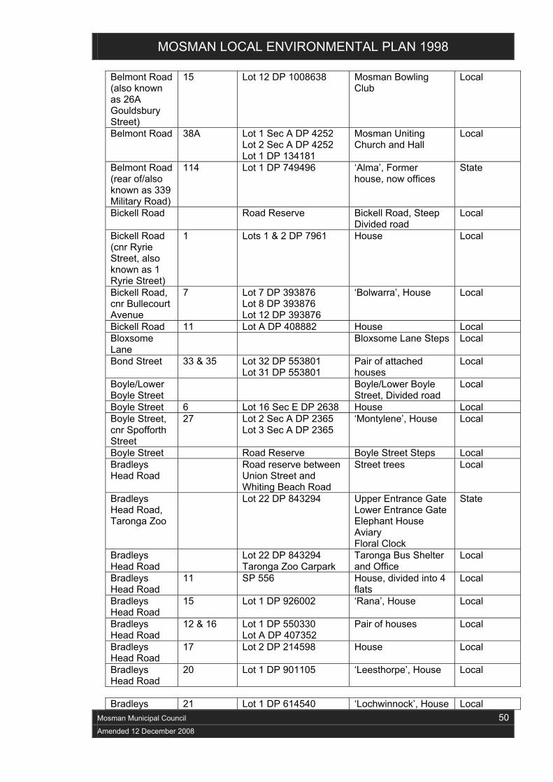
MOSMAN LOCAL ENVIRONMENTAL PLAN 1998
Mosman Municipal Council 50
Amended 12 December 2008
Belmont Road (also known as 26A Gouldsbury Street)
15 Lot 12 DP 1008638 Mosman Bowling Club
Local
Belmont Road 38A Lot 1 Sec A DP 4252 Lot 2 Sec A DP 4252 Lot 1 DP 134181
Mosman Uniting Church and Hall
Local
Belmont Road (rear of/also known as 339 Military Road)
114 Lot 1 DP 749496 ‘Alma’, Former house, now offices
State
Bickell Road Road Reserve Bickell Road, Steep Divided road
Local
Bickell Road (cnr Ryrie Street, also known as 1 Ryrie Street)
1 Lots 1 & 2 DP 7961 House Local
Bickell Road, cnr Bullecourt Avenue
7 Lot 7 DP 393876 Lot 8 DP 393876 Lot 12 DP 393876
‘Bolwarra’, House Local
Bickell Road 11 Lot A DP 408882 House Local Bloxsome Lane
Bloxsome Lane Steps Local
Bond Street 33 & 35 Lot 32 DP 553801 Lot 31 DP 553801
Pair of attached houses
Local
Boyle/Lower Boyle Street
Boyle/Lower Boyle Street, Divided road
Local
Boyle Street 6 Lot 16 Sec E DP 2638 House Local Boyle Street, cnr Spofforth Street
27 Lot 2 Sec A DP 2365 Lot 3 Sec A DP 2365
‘Montylene’, House Local
Boyle Street Road Reserve Boyle Street Steps Local Bradleys Head Road
Road reserve between Union Street and Whiting Beach Road
Street trees Local
Bradleys Head Road, Taronga Zoo
Lot 22 DP 843294 Upper Entrance Gate Lower Entrance Gate Elephant House Aviary Floral Clock
State
Bradleys Head Road
Lot 22 DP 843294 Taronga Zoo Carpark
Taronga Bus Shelter and Office
Local
Bradleys Head Road
11 SP 556 House, divided into 4 flats
Local
Bradleys Head Road
15 Lot 1 DP 926002 ‘Rana’, House Local
Bradleys Head Road
12 & 16 Lot 1 DP 550330 Lot A DP 407352
Pair of houses Local
Bradleys Head Road
17 Lot 2 DP 214598 House Local
Bradleys Head Road
20 Lot 1 DP 901105 ‘Leesthorpe’, House Local
Bradleys 21 Lot 1 DP 614540 ‘Lochwinnock’, House Local

MOSMAN LOCAL ENVIRONMENTAL PLAN 1998
Mosman Municipal Council 51
Amended 12 December 2008
Head Road, cnr Thompson Street Bradleys Head Road
30 Lot B DP 415734 House Local
Bradleys Head Road
40 DP 921008 DP 938207
House Local
Bradleys Head Road, cnr Union Street
50 Pt 1 DP 3715 Pt 2 DP 3715
‘Strathairlie’, House Local
Bradleys Head Road
53 Lot 4 DP 456195 ‘Gooyang’, House Local
Bradleys Head Road
54 Lot A DP 957002 ‘Nagoya Castle’, House
State
Bradleys Head Road
56 Lot B DP 957002 ‘Westmeath’, House Local
Bradleys Head Road, cnr Ellamatta Avenue
59 Pt 1 DP 3479 Presbytery (Blessed Sacrament Church)
Local
Bradleys Head Road
62–64 Lot 36 DP 3627 Lot 37 DP 3627
Blessed Sacrament Church
Local
Bradleys Head Road, cnr Effingham Street
63 Lot 10 DP 875220 ‘Trelawney’, House Local
Bradleys Head Road
96A Lot 1 DP 781262 Mosman Police Station
Local
Bray Street Road Reserve Bray Street, Divided road
Local
Bray Street 2 Lot 31 DP 3985 ‘Bray Cottage’, House Local Brierley Street Lot 2 DP 213091 Cartref Park Local Brierley Street, cnr Cartref Lane
19 Lot 1 DP 213091 ‘Cartref’, House Local
Brierley Street 20 Lot 39 Sec C DP 2509 Lot 40 Sec C DP 2509
‘Hawlock’, House and garden
Local
Brierley Street 26 SP 62759 ‘Brierwood’, Flats Local Buena Vista Avenue
1 Lot 1 DP 956163 House Local
Buena Vista Avenue
2 Lot C DP 922541 ‘Urunga’, House Local
Buena Vista Avenue
4 Lot 2 DP 314165 House Local
Buena Vista Avenue
6 Lot 1 DP 135538 ‘Curraweena’, House Local
Buena Vista Avenue
10 Lot 2 DP 181356 ‘Kew Place’, House Local
Buena Vista Avenue
12 & 14 Lot 2 DP 187227 Lot 1 DP 187227
Pair of houses ‘Airlie’ (No 12)
Local
Bullecourt Avenue
Road Reserve Bullecourt Avenue, Divided road
Local
Bullecourt 34 Lot B DP 408882 House State

MOSMAN LOCAL ENVIRONMENTAL PLAN 1998
Mosman Municipal Council 52
Amended 12 December 2008
Avenue Burran Avenue
Road Reserve Burran Avenue, Divided road
Local
Burrawong Avenue and Clifton Street
Road Reserve Burrawong Avenue/Clifton Street, Divided road
Local
Burrawong Avenue and Illuka Road
Burrawong Avenue/Illuka Road Steps
Local
Burrawong Avenue
16 Lot 9 Sec 4 DP 2395 House Local
Burrawong Avenue
40 Lot 6 Sec 5 DP 6294 House Local
Cabban Street
Cabban Street, Divided road
Local
Cabramatta Road
39 & 41 Lot 17 Sec 3 DP 2311 Lot 16 Sec 3 DP 2311
Group of 2 Houses ‘Feldwick’ (No 39)
Local
Calypso Avenue
Road Reserve Calypso Avenue, Divided road
Local
Calypso Avenue, cnr Magic Grove
17 Lot B DP 381265 House State
Calypso Avenue
28A Lot 2 DP 363188 Electrical Substation No 794
Local
Cardinal Street
13 & 15 Lot 1 DP 115784 SP 21691
Group of 2 houses Local
Carrington Avenue/ Inkerman Street
Quakers Hat Baths Remnant
Local
Carrington Avenue/ Inkerman Street
Carrington Avenue/ Quakers Hat Bay Steps
Local
Carrington Avenue
15–17 Lot B DP 329365 House Local
Centenary Drive (off Harnett Avenue)
Between Harnett Park and Mosman Marina
Mosman Rowing Club
Local
Central Avenue
11 SP 10936 Flats Local
Central Avenue
13 & 15 Lots 10 & 11 DP 4000 Group of 2 houses Local
Chowder Bay Road
Lot 2 DP 831153 Army Maritime School
State
Chowder Bay Road
Lot 2 DP 831153 Naval Caretakers Quarters
Local
Chowder Bay Road
Lot 2 DP 831153 Original Naval Fuel Storage Tanks
State
Clanalpine Street
Road Reserve Clanalpine Street, Divided road
Local
Clanalpine Street
2 Lot 6 DP 60889 Flats Local
Clanalpine 4 Lot 24 DP 738552 House Local

MOSMAN LOCAL ENVIRONMENTAL PLAN 1998
Mosman Municipal Council 53
Amended 12 December 2008
Street Clanalpine Street
18 Lot 1 DP 972665 Lot 4 DP 455961
House, in the form of a terrace pair
Local
Clanalpine Street
55 Lot 1 DP 38132 House Local
Clifton Gardens Reserve, Morella Road
Clifton Gardens Reserve
Local
Clifton Gardens Reserve, Morella Road
Chowder Bay Wharf and Pool in Clifton Gardens Reserve
Local
Clifton Gardens Reserve, Morella Road
Sewage Pumping Station No 54
Local
Congewoi Lane/ Macpherson Street
Congewoi Lane Steps
Local
Cowles Road (cnr Wolger Road, also Ballantyne Street)
Memory Park Local
Cowles Road (Military Road to Belmont Road)
Road Reserve Street trees Local
Cowles Road, cnr Glover Street
36 Lot B DP 382320 ‘Rivergaro’, House Local
Cowles Road, cnr Belmont Road (also known as 40 Belmont Road)
40 Lot 1 DP 310154 ‘Waveney’, House Local
Cowles Road 42, 44 & 46
Lot C DP 915583 Lot B DP 915583 Lot A DP 915583
Group of 3 houses State
Cowles Road (also known as 89B Cowles Road)
87C Lot 4 DP 536939 ‘The Whitehouse’, former house now offices
Local
The Crescent 27 Lot 46 Sec 1 DP 3513 Pt Lot 45 Sec 1 DP 3513
‘Omaha’, house Local
Cross Street Lot 875 DP 752067 Lot 7062 DP 752067
Rawson Park Local
Cross Street, Rawson Park
The Grandstand Local
Cross Street, Rawson Park
The Keith Anderson Memorial
Local
Cross Street, The Scotland Local

MOSMAN LOCAL ENVIRONMENTAL PLAN 1998
Mosman Municipal Council 54
Amended 12 December 2008
Rawson Park Australia Cairn Cross Street Road Reserve Street trees Local Cross Street 10 Lot 1 DP 962910 ‘Glasslyn’, house Local Crux Lane Crux Lane Local Cyprian Street Cyprian Street
Steep, divided road Local
Dalton Road Road Reserve Road pavement—Dalton Road
Local
Dalton Road 2 Lot 12 DP 605556 ‘Killarney’, former House, now part of retirement village
Local
Dalton Road 8 Lot 9 DP 5745 ‘Clementine’, House Local Dalton Road 29 Lot 1 DP 505766 ‘Coromandel’, House State Dalton Road, cnr Cowles Road
64 Lot 30 DP 5745 House Local
David Street Road Reserve Stone kerb Local Dugald Road Dugald Road, Divided
road Local
Effingham Street
4 Lot 1 DP 131592 House Local
Effingham Street
8 Lot 1 DP 901619 House Local
Elfrida Street/ Sirius Cove Road
Elfrida Street Steps Local
Ellamatta Avenue
1, 3 & 5 Lot 111 DP 884230 Lot 1 DP 927200 Lot 1 DP 931380
Group of 3 houses Local
Erith Street 15 Lot 5 DP 4103 ‘Aotea Roa’, House Local The Esplanade
Balmoral Beach, including Edwards Beach
State
The Esplanade
Balmoral Beach Baths
Local
The Esplanade
Balmoral Beach Promenade
Local
The Esplanade
Balmoral Boatshed - site only
Local
The Esplanade
Bathers Pavilion State
The Esplanade
Balmoral Baths Pavilion
Local
The Esplanade
Lot 7125 DP 1006491 Bus Terminus Office and Shelter
Local
The Esplanade
Clem Morath Pool Local
The Esplanade
Edwards Beach Shark Net
Local
The Esplanade
Bounded by Hunter Road, The Esplanade, Almora Street and Park Lane
Hunter Park, Western Section
Local
The Balmoral Beach Local
Amendment 14 GG No. 154

MOSMAN LOCAL ENVIRONMENTAL PLAN 1998
Mosman Municipal Council 55
Amended 12 December 2008
Esplanade Rotunda The Esplanade
Rocky Point Footbridge and Park Walkway
Local
The Esplanade
Sewage Pumping Stations Nos 69 & 70
Local
Fairfax Road and Burran Avenue
Fairfax Road/ Burran Avenue Steps
Local
Gladstone Avenue, Cnr Keston Avenue
6 SP 11102 ‘Astor’ Flats Local
Glencarron Avenue
2 Lot 2 DP 858379 ‘Iorana’ House Local
Glover Street 4 Lot C DP 300401 Front fence Local Glover Street 48 Lot 12 Sec 2 DP 2311 House Local Glover Street 82 & 84 Lot 1 DP 926574
Lot 2 DP 926574 Pair of houses Local
Glover Street 86 SP 16064 House Local Glover Street 88–90, &
92–94 Lot B DP 394431 Lot A DP 394431 Lot A DP 387796 Lot B DP 387796
2 pairs of semi-detached houses
Local
Gordon Street 5, 7, 9, 11, 13 & 15
Lot D DP 442432 Lot C DP 442432 Lot B DP 442432 Lot A DP 442432 Lot 4 DP 550493 Lot 3 DP 550493
Group of 3 pairs of semi detached houses
State
Gordon Street 12 Lot 2 Sec A DP 1398 House Local Gouldsbury Street
2 Lot 11 DP 1008638 Mosman Primary School
Local
Gouldsbury Street
20, 22, 24, 26 & 28
Lot A DP 444702 Lot B DP 444702 Lot 3 DP 504882 Lot 4 DP 504882 Lot 1 DP 618222
Group of 5 houses Local
Gouldsbury Street
32 Lot 8 Sec 4 DP 3513 Lot 9 Sec 4 DP 3513
The Manse (Scots Kirk)
Local
Gouldsbury Street
34, 36, 38 & 40
Lot 7 Sec 4 DP 3513 Lot 1 DP 523340 Lot 2 DP 523340 Lot 5 Sec 4 DP 3513
Group of 4 houses Local
The Grove 14A Lot 2 DP 329738 House Local Hale Road 8 Lot 2 Sec 2 DP 3308 ‘The Cottage’, Arts
Education Centre Local
Hale Road 12A & 14 Lot 3 DP 831351 Lot 1 DP 831351
‘Oreel’ (14) House with stone fence and garden Stone fence (12A)
Local
Hamlet Lane Hamlet Lane Local Hampden Street
Hampden Street, Divided road
Local
Hampden Hampden Street/ Local
Amendment 21 GG No. 102
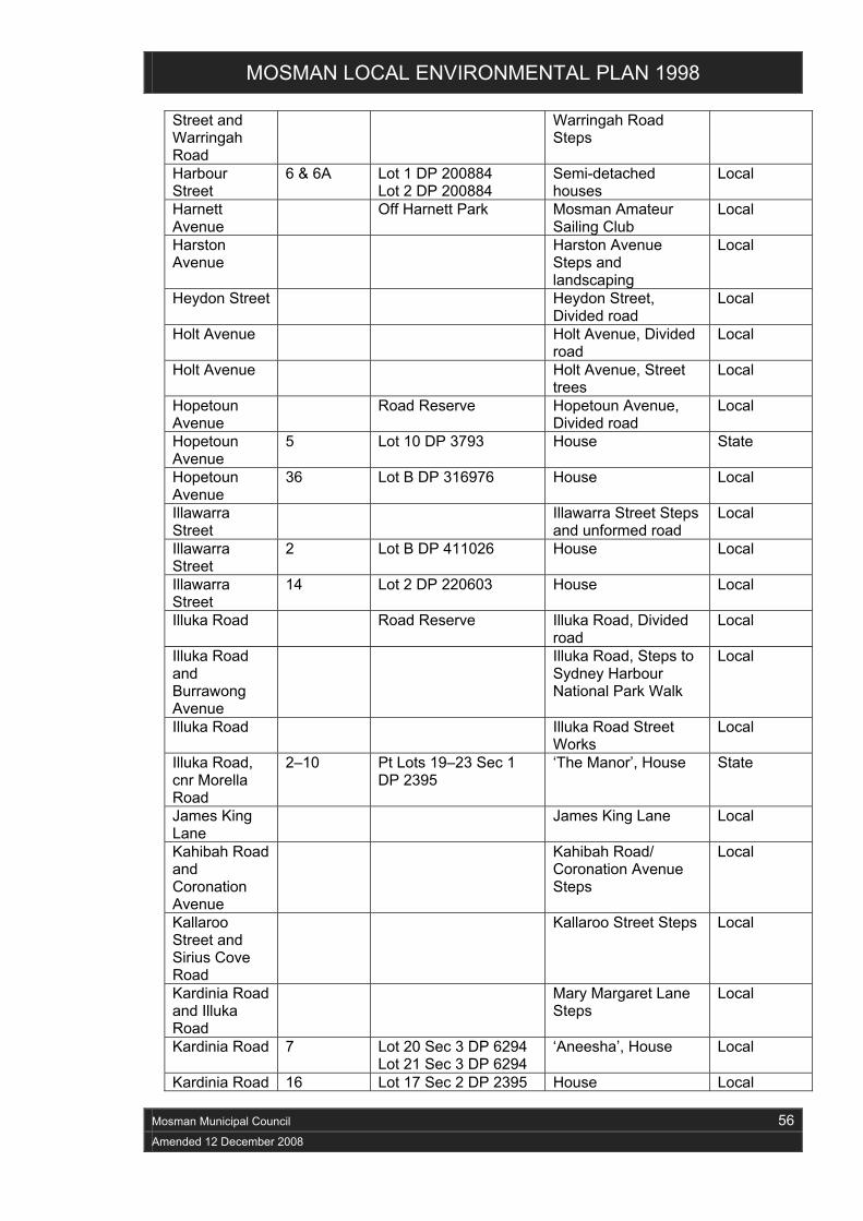
MOSMAN LOCAL ENVIRONMENTAL PLAN 1998
Mosman Municipal Council 56
Amended 12 December 2008
Street and Warringah Road
Warringah Road Steps
Harbour Street
6 & 6A Lot 1 DP 200884 Lot 2 DP 200884
Semi-detached houses
Local
Harnett Avenue
Off Harnett Park Mosman Amateur Sailing Club
Local
Harston Avenue
Harston Avenue Steps and landscaping
Local
Heydon Street Heydon Street, Divided road
Local
Holt Avenue Holt Avenue, Divided road
Local
Holt Avenue Holt Avenue, Street trees
Local
Hopetoun Avenue
Road Reserve Hopetoun Avenue, Divided road
Local
Hopetoun Avenue
5 Lot 10 DP 3793 House State
Hopetoun Avenue
36 Lot B DP 316976 House Local
Illawarra Street
Illawarra Street Steps and unformed road
Local
Illawarra Street
2 Lot B DP 411026 House Local
Illawarra Street
14 Lot 2 DP 220603 House Local
Illuka Road Road Reserve Illuka Road, Divided road
Local
Illuka Road and Burrawong Avenue
Illuka Road, Steps to Sydney Harbour National Park Walk
Local
Illuka Road Illuka Road Street Works
Local
Illuka Road, cnr Morella Road
2–10 Pt Lots 19–23 Sec 1 DP 2395
‘The Manor’, House State
James King Lane
James King Lane Local
Kahibah Road and Coronation Avenue
Kahibah Road/ Coronation Avenue Steps
Local
Kallaroo Street and Sirius Cove Road
Kallaroo Street Steps Local
Kardinia Road and Illuka Road
Mary Margaret Lane Steps
Local
Kardinia Road 7 Lot 20 Sec 3 DP 6294 Lot 21 Sec 3 DP 6294
‘Aneesha’, House Local
Kardinia Road 16 Lot 17 Sec 2 DP 2395 House Local

MOSMAN LOCAL ENVIRONMENTAL PLAN 1998
Mosman Municipal Council 57
Amended 12 December 2008
Kardinia Road 21 Lot 11 Sec 3 DP 2395 House Local Kardinia Road, cnr Burrawong Avenue
42 SP 2494 SP 42391 SP 45267
‘Clifton Manor’, House, divided into 3 flats and front gates
Local
Keston Avenue
11 Lot 1 DP 798679 ‘Kiama’, House Local
Keston Avenue
23–25 & 27–29
Lot 241 DP 619608 Lot 242 DP 619608 Lot B DP 439739 Lot A DP 439739
Group of 2 pairs of semi-detached houses
State
Killarney Street
Unformed Road Reserve
Killarney Street Steps Local
Killarney Street, cnr Bullecourt Avenue
23 Lot 18 DP 10956 Lot 2 DP 584593
House Local
Kiora Avenue Road Reserve Kiora Avenue, Divided road
Local
Kirkoswald Avenue
Road Reserve Kirkoswald Avenue, Divided road
Local
Kirkoswald Avenue
2 Lot B DP 376697 ‘Kirkoswald House’, House
Local
Koowong Avenue
4 Lot 15 DP 22694 House Local
Kurrawong Lane
Road Reserve Kurrawong Lane Local
Lang Street Road Reserve Lang Street, Divided road
Local
Lavoni Street 6 Lot 26 DP 6648 House Local Lavoni Street 18 Lot 32 DP 6648 House State Lennox Street Road Reserve Lennox Street,
Divided road Local
McLeod Street
Road Reserve McLeod Street, Steep divided road
Local
McLeod Street
McLeod Street Steps Local
Major Street Road Reserve Major Street, Divided road
Local
Mandolong Road/Arbutus Street
Mandolong Road/ Arbutus Street Steps
Local
Mandolong Road
13 Lot 12 DP 4022 House Local
Mandolong Road
16 Lot 1 DP 724864 House Local
Mandolong Road
22 Lot 2 DP 85137 House Local
Mandolong Road
59 Lot 56 DP 6314 House and plantings Local
Mandolong Road
67 & 69 SP 12572 Pair of Flat buildings Local
Medusa Street
4 Lot 1 DP 172131 House Local
Melrose 23 Lot A2 DP 430090 Electricity Substation Local

MOSMAN LOCAL ENVIRONMENTAL PLAN 1998
Mosman Municipal Council 58
Amended 12 December 2008
Street No 149 Middle Head Road
Lot 2 DP 604478 AUS AID Training Centre
State
Middle Head Road
Defence Housing Local
Middle Head Road and Suakin Drive
Lot 2 DP 831153 Georges Heights Military Barracks Complex
State
Middle Head Road
Lot 2 DP 831153 Group of Navy Cottages
Local
Middle Head Road
Lot 2 DP 831153 HMAS Penguin Naval Base
Local
Middle Head Road (off Markham Close)
Lot 1 DP 233157 Mosman Scout and Guides Hall
Local
Middle Head Road
Lot 2 DP 604478 10 Terminal Regiment HQ
Local
Middle Head Road
12 Lot A DP 110449 House and grounds Local
Middle Head Road
20 Lot 1 DP 102385 House and grounds Local
Middle Head Road
26 Lot 1 DP 541752 House and garden Local
Middle Head Road
34 Lot 1 DP 4289 ‘Fawley’, House Local
Middle Head Road, cnr Effingham Street
40 Lot 1 DP 901586 House and grounds Local
Middle Head Road
43, 45, 47 & 49
Lot E DP 12576 Lot D DP 12576 Lot C DP 12576 Lot B DP 12576
Group of 4 houses Local
Middle Head Road, cnr King Max Street
46 Pt Y DP 919045 House and ground Local
Middle Head Road
54, 56, 58 & 60
Lot A DP 438858 Lot B DP 438858 Lot C DP 438858 Lot D DP 438858
Terrace group of 4 dwellings
Local
Middle Head Road
115 & 117 Lot B DP 107003 Lot A DP 107003
Semi-detached houses
Local
Middle Head Road
139–153 SP 61182 2-storey façade of 6 shops
Local
Military Road, cnr Macpherson Street
414–416 Lot 21 DP 666687 Commercial building (former bank)
Local
Military Road, cnr Cardinal Street
485–485A Lot 1 DP 845743 Sacred Heart Church Local
Military Road 581–595 Lot 211 DP 813624
Lot 212 DP 813624 8 shops with dwellings above
Local

MOSMAN LOCAL ENVIRONMENTAL PLAN 1998
Mosman Municipal Council 59
Amended 12 December 2008
Lot 13 DP 600250 Lot 14 DP 600250 Lot 5 DP 219883 Lot 61 DP 599894 Lot B DP 440424
Military Road, (incl Nos 29-31 The Crescent)
613-621 Lot 8 Sec 1 DP 3513 Lot 9 Sec 1 DP 3513 Lot 47 Sec 1 DP 3513 Lot 48 Sec 1 DP 3513
Christian Science Reading Room, Sunday School and Third Church of Christ Scientist
State
Military Road 624 Lot 1 DP 739374 ‘Boronia’, former house, now restaurant
State
Military Road, cnr Gouldsbury Street
707 Lot 1 DP 725831 ‘Rothesay’, Café/shops
Local
Military Road 742 Lot 1 DP 4022 Lot 1 DP 172814
Former Anzac Memorial Hall
State
Military Road, cnr Beach Lane
744 SP 53477 House and commercial use
Local
Military Road 769 Bounded by Military Road, Avenue Road, Gladstone Street and Belmont Road
Mosman High School, group of 2 buildings
Local
Military Road, South cnr of Avenue Road
771 SP 32927 Suite of shops with upstairs dwellings
State
Military Road 787–801 Lot 1 DP 595187 Lot 2 DP 550906 Lot 15 DP 630129 Lot 11 DP 534751 Lot 12 DP 534751 Lot 13 DP 595486 Lot 2 DP 585273 Lot 2 DP 582922
Group of 8 shops with dwellings above
Local
Military Road 866–872 Lot 35 DP 224749 Lot 34 DP 224749 Lot 1 DP 514928 Lot 2 DP 514928
‘The Strand’ Shops and upstairs dwellings
Local
Military Road 878 SP 57270 Shop with dwelling Local Milner Street Milner Street, Divided
road Local
Milner Street 4 Lot 27 DP 1571 House Local Milton Avenue 5, 7, 9 &
11 Lot 1 DP 921673 Lot 1 DP 971770 Lot 25 DP 3627 Lot 26 DP 456192 Lot B DP 349400 Lot A DP 349400
Group of 4 houses Local
Mistral Avenue
14 Lot A DP 956310 House Local
Mistral Avenue, cnr
28 Lot 4 DP 611597 Lot 1 DP 556986
House State

MOSMAN LOCAL ENVIRONMENTAL PLAN 1998
Mosman Municipal Council 60
Amended 12 December 2008
Magic Grove (also known as 8 Magic Grove) Morella Road Road Reserve Morella Road,
Divided road Local
Morella Road Sarah’s Walk Steps Local Morella Road Steps to Clifton
Gardens Reserve Local
Morella Road (south)
Beside No 1 Morella Road
Morella Road (south) Steps to Clifton Gardens
Local
Morella Road 5 Lot 3 DP 8543 House and garden State Morella Road 11 Lot 12 DP 9674 House Local Morella Road 17 Lot 1 DP 302384 House Local Morella Road and David Street
18 (Morella Road) and 2-12 David Street
Lots 333-37 Sec 3 DP 6294, Lot 1 DP 304682, Lot 39 DP 651524, and Lots 40-42 Sec 3 DP 6294
Stone walling to front boundary, historic associations with 6 David Street
Local
Morella Road 26 Lot 2 DP 583753 ‘Cara Mia’, House Local Morella Road 30A Lot 3 DP 583799 ‘Vino del Mar’, House Local Moruben Road
Road Reserve Moruben Road, Divided road
Local
Moruben Road, cnr Mandolong Road
2 Lot 1 DP 540317 Lot 2 DP 45675
‘Tower House’, House and stone fence
Local
Moruben Road
6 Lot B DP 311227 House Local
Moruben Road, cnr Awaba Road
47 Lot 23 DP 4021 Lot 24 DP 4021
‘Cora Lynn’, House Local
Mosman Street
Road Reserve Mosman Street, Divided road
Local
Mosman Street/ Mosman Wharf
Mosman Street Steps to Mosman Wharf
Local
Mosman Street
Walkway to No 13 Mosman Street
Local
Mosman Street
9 & 13 SP 5539 Lot 1 DP 900128
House on No 13, Stone front walls to Nos 9 & 13
Local
Mosman Street
35 Lot 3 DP 977101 House Local
Mosman Street
37 & 39 Lot 2 DP 61223 Lot 1 DP 61223
Terrace-type pair of houses
Local
Moss Lane (off Pearl Bay Avenue)
Road Reserve Moss Lane Local
Musgrave Street
Road Reserve Musgrave Street, Divided road
Local
Musgrave Street/Raglan
Herron Walk Steps Local
Amendment 14 GG 154
Amendment 14 GG 154

MOSMAN LOCAL ENVIRONMENTAL PLAN 1998
Mosman Municipal Council 61
Amended 12 December 2008
Street Musgrave Street/Raglan Street, unformed part of McLeod Street
McLeod Street, Unformed road section
Local
Musgrave Street
9A, 9B & 11
Lot 2 DP 534080 Lot 1 DP 534080 Lot 1 DP 926798
Group of 2 houses (3 dwellings)
Local
Musgrave Street
16 Lot B DP 327998 ‘Rutledge Lodge’, House
Local
Musgrave Street
24 Lot 3A DP 449492 House Local
Musgrave Street
28 Lot 2 DP 32915 Historic site Local
Musgrave Street
39 Lot A DP 313281 House Local
Musgrave Street
Lot 1 DP 326448 (between 52A & 54)
Electricity Substation No 380 and front fence
Local
Muston Street 2 & 4-6 Lot 2 DP 3396 SP 5085
Front fence (stone wall)
Local
Muston Street, cnr Almora Street
81 Lot 21 DP 3953 House Local
Muston Street 97 Lot 29 DP 3953 House Local Muston Street 102 Lot 111 DP 774079 House Local Myahgah Road, Civic Square
Closed portion of Myahgah Road, outside Mosman Council offices
Leahy Memorial Local
Myahgah Road, Civic Square
Closed portion of Myahgah Road
The Antico Fountain Local
Myahgah Road, cnr Short Street
25A Lot 13 DP 2717 Lot 14 DP 2717
Mosman Community Centre
Local
Myahgah Road and The Crescent
Lot 1 DP 919853 Mosman Park—oval and park
Local
Myahgah Road, cnr The Crescent
War Memorial and Steps
Local
New Lane Road Reserve New Lane Local Noble Street (Rear 84 Avenue Road)
1A Lot 1 DP 115997 Electrical Substation No 207
Local
Nock Lane Road Reserve Nock Lane Local Orlando Avenue
South end Orlando Avenue
McCauley Outlook - Unformed road
Local
Orlando Avenue
24 Lot 28 Sec A DP 2365 ‘Talarah’, House Local
Orlando Avenue
30 Lot D DP 409287 Lot E DP 409287
House Local
Amendment 14 GG No. 154

MOSMAN LOCAL ENVIRONMENTAL PLAN 1998
Mosman Municipal Council 62
Amended 12 December 2008
Oswald Street/ Park Avenue
From Oswald/ Reginald Streets through to Park Avenue
Oswald Street/ Park Avenue Steps
Local
Oswald Street 2 Lot 26 Sec C DP 2509 House and garden Local Ourimbah Road, cnr Heydon Street
Lot 67 DP 3994 Lot 68 DP 3994
St Luke’s Anglican Church Group
Local
Ourimbah Road, cnr Brady Street
8–34 Lot 1 DP 225539 Lot 2 DP 225539 Lot 91 DP 877997 Lot 92 DP 877997 Lot 81 DP 586004 Lot 82 DP 586004 Lot 12 DP 584804 Lot 11 DP 584804 Lot A DP 393858 Lot B DP 393858 Lot A DP 447934 Lot B DP 447934 Lot 1 DP 576982 Lot 2 DP 576982
Group of 7 pairs of semi-detached cottages
Local
Ourimbah Road, cnr Rosebery Street
60 SP 12208 Shops and Flats Local
Park Avenue Road Reserve Park Avenue, Divided road
Local
Park Avenue/ Avenue Road
Park Avenue/ Avenue Road Steps
Local
Park Avenue 36A SP 8031 Flats Local Parriwi Park Lot 263 DP 752067 Parriwi Park Local Parriwi Road/ Kiora Avenue
Between 17 & 19 Parriwi Road (through to Kiora Avenue)
Barney Kearns Steps Local
Parriwi Road Burkes Steps Local Parriwi Road Bus shelter Local Parriwi Road Middle Harbour
Sewerage Syphon Local
Parriwi Road 46 Lot 3 DP 17697 Lot 4 DP 17697
House and Garden Local
Parriwi Road 53B & 53 Lot 1 DP 800420 Lot 2 DP 800420
Rosherville Lighthouse
Local
Parriwi Road 65 Lot 17 DP 71366 House State Pearl Bay Avenue/ Delecta Avenue (Marsala Street)
Pearl Bay Avenue/Delecta Avenue (Marsala Street) Steps
Local
Pearl Bay, Middle Harbour
Houseboat No 3 Local
Pearl Bay Avenue
10 Lot 26 DP 8492 House Local
Pearl Bay 16 Lot 29 DP 8492 ‘Atherton’, House Local
Amendment 21 GG No. 102

MOSMAN LOCAL ENVIRONMENTAL PLAN 1998
Mosman Municipal Council 63
Amended 12 December 2008
Avenue, cnr Moss Lane Pretoria Avenue
Pretoria Avenue Steps
Local
Prince Albert Street
Road Reserve Prince Albert Street, Divided road
Local
Prince Albert Street
3 Lot 2 DP 601067 House Local
Prince Albert Street
5 & 7 Lot 1 DP 601067 Lot 1 DP 902590
Pair of houses Local
Prince Albert Street
13 Lot 1 DP 932354 ‘Candida’, House Local
Prince Albert Street
19 Lot A DP 389110 ‘Ardagh’, House State
Prince Albert Street
21 & 23 Lot 1 DP 901720 Lot D DP 435443
Pair of houses Local
Prince Albert Street
24 Lot 11 DP 8397 ‘Araluen Heights’, House
Local
Prince Albert Street
27 Lot 2 DP 105546 House Local
Prince Albert Street, cnr Union Street
37 Lot 1 DP 983943 House Local
Prince Albert Street
45 Lot 1 DP 900685 ‘Ravenstan’, House State
Prince Albert Street
70 SP 14335 ‘Alameda’ Flats Local
Prince Albert Street, cnr Queen Street
74 Lot 2 DP 208058 House Local
Prince Albert Street
98 Lot 11 DP 455964 Lot 12 DP 976424
House Local
Prince Albert Street, cnr Raglan Street
120–122 SP 22664 Group of shops with dwellings above
State
Prince Lane Road Reserve Prince Lane Local Prince Street 49 & 49A Lots 1 & 2 DP 590014 House (divided into 2
dwellings) Local
Prince Street 46, 48 & 50
Lot 1 DP 100298 Lot 1 DP 922508 Lot 1 DP 925077
Group of 3 houses Local
Prince Street 66B SP 9101 ‘Clumba Court’, Flats Local Pulpit Lane Pulpit Lane Steps to
Beauty Point Foreshores Walk
Local
Punch Street 4 Lot 1 DP 918187 ‘Hendon’, House Local Quakers Road
Quakers Road steps Local
Queen Street, cnr Milton Avenue
2 Lot 5–8 DP 3627 Lot 1 DP 212571 Lot 1 DP 205962
Blessed Sacrament School
Local
Queen Street 6 Lot 1 DP 791997 Queenwood School for Girls
Local
Queen Street, cnr Clanalpine
16A 18–20
Lot 1 DP 981534 Lot 4 DP 522939
Group of 5 dwellings Local
Amendment 21 GG No. 102
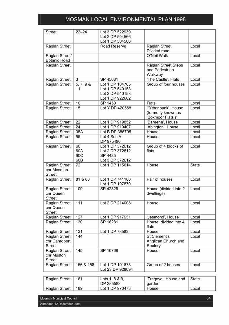
MOSMAN LOCAL ENVIRONMENTAL PLAN 1998
Mosman Municipal Council 64
Amended 12 December 2008
Street 22–24 Lot 3 DP 522939 Lot 2 DP 504566 Lot 1 DP 504566
Raglan Street Road Reserve Raglan Street, Divided road
Local
Raglan Street/ Botanic Road
O’Neil Walk Local
Raglan Street Raglan Street Steps and Pedestrian Walkway
Local
Raglan Street 3 SP 45081 ‘The Castle’, Flats Local Raglan Street 5, 7, 9 &
11 Lot 1 DP 104765 Lot 1 DP 540158 Lot 2 DP 540158 Lot 1 DP 922602
Group of four houses Local
Raglan Street 10 SP 1450 Flats Local Raglan Street 15 Lot Y DP 420568 “‘Ythanbank’, House
(formerly known as ‘Boxmoor Flats’)”
Local
Raglan Street 22 Lot 1 DP 919852 ‘Bareena’, House Local Raglan Street 24 Lot 1 DP 919407 ‘Abington’, House Local Raglan Street 35A Lot B DP 386795 House Local Raglan Street 55 Lot 4 Sec A
DP 975490 House Local
Raglan Street 60 60A 60C 60B
Lot 1 DP 372612 Lot 2 DP 372612 SP 4485 Lot 3 DP 372612
Group of 4 blocks of flats
Local
Raglan Street, cnr Mosman Street
72 Lot 1 DP 115014 House State
Raglan Street 81 & 83 Lot 1 DP 741186 Lot 1 DP 197870
Pair of houses Local
Raglan Street, cnr Queen Street
109 SP 42325 House (divided into 2 dwellings)
Local
Raglan Street, cnr Queen Street
111 Lot 2 DP 214008 House Local
Raglan Street 127 Lot 1 DP 917951 ‘Jesmond’, House Local Raglan Street 130 SP 16281 House, divided into 4
flats Local
Raglan Street 131 Lot 1 DP 78583 House Local Raglan Street, cnr Canrobert Street
144 St Clement’s Anglican Church and Rectory
Local
Raglan Street, cnr Muston Street
145 SP 16768 House Local
Raglan Street 156 & 158 Lot 1 DP 101878 Lot 23 DP 928094
Group of 2 houses Local
Raglan Street 161 Lots 1, 8 & 9,
DP 285582 ‘Tregoyd’, House and garden
State
Raglan Street 189 Lot 1 DP 970473 House Local

MOSMAN LOCAL ENVIRONMENTAL PLAN 1998
Mosman Municipal Council 65
Amended 12 December 2008
Raglan Street, cnr Redan Street
200 (also known as 200A)
Lot 1 DP 917840 ‘Boondabah’, House Local
Raglan Street 200B Lot B DP 322321 House Local Raglan Street 218 Lot 1 DP 925220 House Local Raglan Street 243 SP12621 Flats Local Rangers Avenue
Road Reserve Rangers Avenue, Divided road
Local
Rangers Avenue
Stone culvert Local
Rangers Avenue
69 Lot 2 DP 527924 House State
Rangers Avenue
101A Lot 1 DP 315777 (Between 59 Spofforth Street & 101 Rangers Avenue)
Electrical Substation No 208
Local
Redan Street Road Reserve Redan Street, Divided road
Local
Redan Street 5 & 7 SP 31955 SP 14519
Group of 2 blocks of flats
Local
Redan Street 9, 11 & 11A
Lot 4 DP 8684 Lot 5 DP 8684 Lot 6 DP 8684
Group of 3 houses Local
Redan Street 12 Lot 1 DP 455989 DP 913559
House Local
Redan Street 18 Lot 1 DP 115715 House Local Redan Street 28 Lot 21 DP 1350
Lot 22 DP 1350 House Local
Redan Street, cnr Balmoral Avenue
29 Lot 11 DP 4251 House Local
Redan Street 36–38 Lot B DP 438077 Lot A DP 438077
Pair of semi-detached houses
State
Redan Street 37A Lot 1 DP 321248 (Fronting 37 Redan Street)
Electrical Substation No 205
Local
Reginald Street
31–33 Lot 2 DP 511641 Lot 1 DP 511641
Pair of semi-detached houses
Local
Rose Crescent
Road Reserve Rose Crescent, Divided road
Local
Rosebery Street
Road Reserve Rosebery Street, Divided road
Local
Rosherville Reserve
Rosherville Reserve Local
Royalist Road Road Reserve Royalist Road, Divided road
Local
Ruby Street Road Reserve Ruby Street, Divided road
Local
Ruby Street 6 Lot A DP 378291 House Local Ryan Avenue/ Balmoral Avenue
Ryan Avenue Steps Local
Sadlier Walk (between Awaba Street
Sadlier Walk Pedestrian Way
Local

MOSMAN LOCAL ENVIRONMENTAL PLAN 1998
Mosman Municipal Council 66
Amended 12 December 2008
and Dalton Road) Shadforth Street
11 & 13 Lot A DP 436554 Lot B DP 436554
Pair of houses Local
Shadforth Street, cnr Crux Street
24 Lot 56 DP 34076 House Local
Shadforth Street
34 Lot 1 DP 198499 ‘Winter-garden’, House
Local
Shadforth Street
36–38 & 40–42
Lot 1 DP 785875 Lot 1 DP 641761 Lot 1 DP 589154 Lot 2 DP 589154
Group of 2 semi-detached pairs
Local
Shadforth Street
53 Lot 3A DP 378615 ‘Motfield’, House Local
Shadforth Street
70 & 72 Lot B DP 158943 Lot A DP 158943
House, divided into 2 occupancies
Local
Shadforth Street
71 Mosman Church of England Preparatory School Group
Local
Shadforth Street
85–87 Lot 11 DP 76778 Lot 12 DP 974982
Pair of houses Local
Shadforth Street
99–101 Lot 12 DP 806116 Lot 11 DP 806116
Semi-detached pair of houses
Local
Shadforth Street, cnr Hamlet Lane
107 Lot 1 DP 539812 ‘Hamlet House’, House
State
Silex Road 11A SP 13603 Flats Local Silex Road 13 Lot A DP 367843 House Local Sirius Cove Road, at Sirius Avenue
Footbridge over Sirius Cove Road
Local
Sirius Cove Road
Sirius Cove Seawall Local
Sirius Cove Road
1A Lot 1 DP 86329 Lot 2 DP 86329
House Local
Sirius Park (Between Sirius Cove Road and Curlew Camp Road)
Divided road through Sirius Park
Local
Spencer Road Road Reserve Divided road and Street Trees
Local
Spencer Road 64 Lot 1 DP 945643 House Local Spit Road/Parriwi Road
(Between 191 and 193 Spit Road, 30 & 32 Parriwi Road)
Quarry Steps Local
Spit Road Spit Bridge State Spit Road 42-44 Lot 29 DP 3994 Mosman Masonic
Centre Local
Spit Road 51 SP 30300 ‘Jerpoint’, Flats Local Spit Road (Rear - on Punch Lane)
61 Lot 2 DP 229664 Electrical Substation No 204
Local
Spit Road, cnr Ourimbah Road
68 SP14513 Former House, now flats
Local
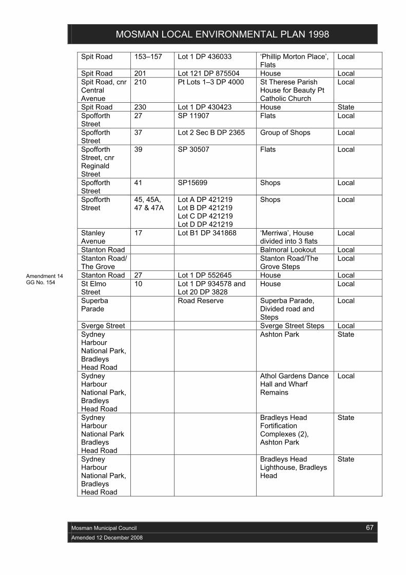
MOSMAN LOCAL ENVIRONMENTAL PLAN 1998
Mosman Municipal Council 67
Amended 12 December 2008
Spit Road 153–157 Lot 1 DP 436033 ‘Phillip Morton Place’, Flats
Local
Spit Road 201 Lot 121 DP 875504 House Local Spit Road, cnr Central Avenue
210 Pt Lots 1–3 DP 4000 St Therese Parish House for Beauty Pt Catholic Church
Local
Spit Road 230 Lot 1 DP 430423 House State Spofforth Street
27 SP 11907 Flats Local
Spofforth Street
37 Lot 2 Sec B DP 2365 Group of Shops Local
Spofforth Street, cnr Reginald Street
39 SP 30507 Flats Local
Spofforth Street
41 SP15699 Shops Local
Spofforth Street
45, 45A, 47 & 47A
Lot A DP 421219 Lot B DP 421219 Lot C DP 421219 Lot D DP 421219
Shops Local
Stanley Avenue
17 Lot B1 DP 341868 ‘Merriwa’, House divided into 3 flats
Local
Stanton Road Balmoral Lookout Local Stanton Road/ The Grove
Stanton Road/The Grove Steps
Local
Stanton Road 27 Lot 1 DP 552645 House Local St Elmo Street
10 Lot 1 DP 934578 and Lot 20 DP 3828
House Local
Superba Parade
Road Reserve Superba Parade, Divided road and Steps
Local
Sverge Street Sverge Street Steps Local Sydney Harbour National Park, Bradleys Head Road
Ashton Park State
Sydney Harbour National Park, Bradleys Head Road
Athol Gardens Dance Hall and Wharf Remains
Local
Sydney Harbour National Park Bradleys Head Road
Bradleys Head Fortification Complexes (2), Ashton Park
State
Sydney Harbour National Park, Bradleys Head Road
Bradleys Head Lighthouse, Bradleys Head
State
Amendment 14 GG No. 154

MOSMAN LOCAL ENVIRONMENTAL PLAN 1998
Mosman Municipal Council 68
Amended 12 December 2008
Sydney Harbour National Park, Bradleys Head Road
Sandstone Pillar, Bradleys Head
Local
Sydney Harbour National Park, Chowder Bay Road
Lot 1 DP 604478 Georges Head Fortifications Complex
State
Sydney Harbour National Park, Chowder Bay Road
Obelisk Point Fortifications Complex
State
Sydney Harbour National Park, Chowder Bay Road
Pair of Navigational Obelisks
Local
Sydney Harbour National Park, Chowder Bay Road
Rock Casemate State
Sydney Harbour National Park, Chowder Bay Road
Semi- Underground Armoured Casemate Battery
State
Sydney Harbour National Park, Old Fort Road
Middle Head Fort Complex
State
Thompson Street
4 SP12375 Flats State
Thompson Street, cnr Silex Road
7 Lot 2 DP 324874 ‘Rothesay’, House Local
Thompson Street, cnr St Elmo Street (also known as 4 St Elmo)
12 Lot 2 DP 962380 House, divided into 2 occupancies
Local
Tivoli Street 2 Lot 1 DP 946855 ‘Corrielyn’, House Local Tivoli Street 5-7 Lot 2 DP 316033
Lot 1 DP 316033 Semi-detached pair Local
Tivoli Street 14 Lot B DP 390148 House Local Upper Avenue Road
Road Reserve Upper Avenue Road, Divided road
Local
Upper Avenue Road/Crux Street (unformed)
Road Reserve
Upper Avenue Road/Crux Street (unformed), Unformed road
Local
Upper Fairfax Road
Road Reserve Upper Fairfax Road, Divided road
Local

MOSMAN LOCAL ENVIRONMENTAL PLAN 1998
Mosman Municipal Council 69
Amended 12 December 2008
Upper Spit Road/Parriwi Road
Upper Spit Road/Parriwi Road Steps
Local
Upper Spit Road
1 Lot A DP 339624 Flats Local
Upper Spit Road, Mosman
7 Lot 100 DP 583214 Lot 101 DP 583214
‘Easterly’, House Local
Upper Spit Road, Mosman
13 Lot 1 DP 216853 ‘Sessiagh’, House Local
Warringah Lane
Road Reserve Warringah Lane Local
Warringah Road
Road Reserve Warringah Road, Divided road
Local
Water Lane Water Lane Pathway Local Whiting Beach Road, cnr Prince Albert Street
9 Lot 6 DP 8400 House Local
Wolger Road 9 Lot B DP 331985 House Local Wolseley Road
Road Reserve Wolseley Road, Divided road
Local
Wolseley Road
34 Lot G DP 918077 ‘Yattendon’, House Local
Wudgong Walk
Wudgong Walk Pathway
Local
Wunda Road Road Reserve Wunda Road, Divided road
Local
Wunda Road 25 Lot 1 DP 934781 House Local Wyargine Street/The Esplanade
Wyargine Street/The Esplanade Steps
Local
Wyargine Street
6–8 SP 4856 ‘Stancliff’, Flats State
Wyong Road Wyong Road, Divided road
Local
Wyong Road/ Shellbank Avenue
Wyong Road—Steps to Shellbank Avenue
Local
Wyong Road 73 Lot 5 DP 16492 Lot 6 DP 16492 Lot 7 DP 16492 Lot 8 DP 16492
‘Shellbank’, House Local

MOSMAN LOCAL ENVIRONMENTAL PLAN 1998
Mosman Municipal Council 70
Amended 12 December 2008
Schedule 2A Heritage Conservation Areas (Schedule 1) Note. The extent of all heritage conservation areas can be seen on the Heritage Conservation
Map.
Number Name of Heritage Conservation Area
1 Bradleys Head Road Conservation Area
2 The Crescent Conservation Area
3 Holt Estate Conservation Area
4 Keston Avenue Conservation Area
5 Killarney Estate Conservation Area
6 Lang Street Conservation Area
7 Military Road Conservation Area
8 Orlando Conservation Area
9 Raglan Street Conservation Area
10 Shadforth Street Conservation Area
11 Upper Avenue Road Conservation Area
Amendment 1 GG No. 41

MOSMAN LOCAL ENVIRONMENTAL PLAN 1998
Mosman Municipal Council 71
Amended 12 December 2008
Schedule 3 Archeological Sites (Schedule 1)
Street Street No Property description Name of item Level of significance
Avenue Road Road Reserve at end of Avenue Road
Former Tram Terminus, including enclosing sandstone walls
Local
Avenue Road 65A–69A Excavated indentation on eastern side of Avenue Road
Former Stone Quarry
Local
Athol Wharf Road
Road reserve adjacent to Taronga Zoo Ferry Wharf
Former Athol Wharf Tram Terminus, including escarpment and retaining walls
Local
Athol Wharf Road
Taronga Zoo Ferry Wharf
Site of first wharf serving Taronga Zoo
Local
Centenary Drive, Mosman Bay
Sandstone seawall around Quarry Point between Mosman Rowers Club and Mosman Amateur Sailing Club
Former Quarry Wharf
Local
The Esplanade From end Mulbring Street to Plunkett Road through public reserve
Abandoned tramway cutting
Local
Harnett Avenue and Royalist Road
Steep escarpment between Harnett Avenue and Royalist Road from end of Calliope Street to waterfront
Site of former Harnett’s Quarry
Local
Sydney Harbour National Park
National park at Middle Head, Georges Heights, Taylors Head and Bradleys Head
Sydney Harbour National Park
State
Middle Head Road HMAS Penguin Naval Depot
Ventilation stack and former original septic tank, now a swimming pool
Local
Musgrave Street
At end of Musgrave Street
Site of original 1870s Musgrave Street wharf
Local
Parriwi Road Remains of Grant’s Wharf
Local
Pearl Bay Avenue
Site of former Pearl Bay Pleasure Grounds
Local
Public land Aboriginal sites listed in Mosman Municipality Study of Aboriginal Sites
Amendment 1 GG No. 41

MOSMAN LOCAL ENVIRONMENTAL PLAN 1998
Mosman Municipal Council 72
Amended 12 December 2008
Street Street No Property description Name of item Level of significance
1991, available at the office of the Council
Sirius Cove Road
Bushland between Little Sirius Cove and Whiting Beach
Sites of Curlew and Mia Mia Camps
Local
Spit Road Site of former Explosives Wharf
Local
Spit Road Remains of former bridge and seawall
Local
Upper Spit Road
Parriwi Park, end of Upper Spit Road
Site of former road to the Spit
Local

MOSMAN LOCAL ENVIRONMENTAL PLAN 1998
Mosman Municipal Council 73
Amended 12 December 2008
Schedule 4 Original Estate Roads (Clause 36)
Road Reserve Estate or Other Description
Avenue Road Mosman Bay Township
Bradleys Head Road Mosman Bay Township
Cross Street Silex Estate
Crux Street Mosman Bay Township
Fairfax Road Park Gate Estate
Government Road Park Gate Estate
Grecia Lane (M6) Park Gate Estate
Hamlet Lane (M58) Mosman Bay Township
King Max Street Silex Estate
Lane M1 (Bay Street to Water Street) Park Gate Estate
Lane M3 (Ida Avenue to Pearl Bay Avenue) Park Gate Estate
Barney Kearns Steps (Parriwi Road to Kiora Avenue)
Park Gate Estate
Lane M50 Silex Estate
Marsala Street Park Gate Estate
Military Road (from Spofforth Street to Middle Head Road)
Historic Road Alignment
Mitchell Road Park Gate Estate
Prince Albert Street Silex Estate
Quakers Road Park Gate Estate
Queen Street Silex Estate
Raglan Street Mosman Bay Township
Rosherville Road Park Gate Estate
Shadforth Street Mosman Bay Township
Spit and Parriwi Roads (from Spit Junction to James Street)
Historic Road Alignment
Union Street Silex Estate
Upper Fairfax Road Park Gate Estate
Water Lane (M53) Silex Estate

MOSMAN LOCAL ENVIRONMENTAL PLAN 1998
Mosman Municipal Council 74
Amended 12 December 2008
Schedule 4A Significant Interiors (Heritage Items Of State Significance Only) (Clause 38A)
Amendment 1 GG No. 41

MOSMAN LOCAL ENVIRONMENTAL PLAN 1998
Mosman Municipal Council 75
Amended 12 December 2008
Schedule 5 Classification and Reclassification of Public Land (Clause 39)

MOSMAN LOCAL ENVIRONMENTAL PLAN 1998
Mosman Municipal Council 76
Amended 12 December 2008
Schedule 6 Exceptions (Clause 40(1)) Property Development
Development for the purpose of professional health services (including preventative care, diagnosis, medical or surgical treatment or counselling), if:
(a) the gross floor area of the premises does not exceed 430 square metres, and
(b) the height of the building does not exceed 12.6 metres, and
748 - 752 Military Road (Lot 921 DP 807617)
(c) the landscaped area is not less than 484 square metres.
Balmoral Bathers Pavilion, 4 The Esplanade
Development for the purpose of a restaurant.
Balmoral Baths Pavilion, 2A The Esplanade
Development for the purpose of a restaurant.
Development for the purpose of commercial premises or a shop, if:
(a) the commercial premises or shop occupies an area not greater than 86 square metres, is confined to the ground floor of the building and occupies the part of the building having direct pedestrian access to Military Road, and
(b) the remainder of the building is to be used solely for the purpose of a single dwelling, and
(c) the original fabric of the building is conserved, and
744 Military Road (Lot 10, DP 771687)
(d) the residential amenity and character of the garden setting of the building is retained.
The section of Stanton Road, Mosman, fronting 22B Burran Avenue, Mosman (Lot 5, DP 539344). (Amendment 8)
Development for the purpose of vehicular access to 22B Burran Avenue, Mosman.
Mosman Bowling Club (Lot 12, DP 1008638, 15 Belmont Road, Mosman)
Development for the purpose of a bowling club and ancillary uses.
Unformed section of Amaroo Crescent, Mosman, zoned 7 (a) Environment Protection (Bushland), fronting 3 Windward Avenue, Mosman (Part Lot 1, DP 12611), as shown on Engineering Drawing titled “Proposed property access and turning path”, Drawing Number C01 Issue 02, prepared by Jeff Moulsdale & Associates and dated November 2002, approved by the Council on 12 November 2002 and deposited in the office of the Council.
Development for the purpose of vehicular access to the rear of 3 Windward Avenue, Mosman.
Amendment 8 GG No. 48
Amendment 4 GG No. 25
Amendment 15 GG No. 33

MOSMAN LOCAL ENVIRONMENTAL PLAN 1998
Mosman Municipal Council 77
Amended 12 December 2008
647 and 653 Military Road (Lot 15, DP 663532 and Lot 16, Section 1, DP 3513)
Development for the purposes of commercial premises or a shop (other than a shop used principally for the preparation and sale of food by retail), if:
(a) development for such a purpose is carried out on the ground floor only, and
(b) the maximum floorspace ratio for that part of the development as is development for such a purpose does not exceed 0.3:1; and
(c) the maximum floorspace ratio of all development on the site does not exceed 1:1, and
(d) the façade elements and landscaped setting of the building at No 653 Military Road are maintained and integrated into the development; and
(e) the residential and commercial development of Nos 647 and 653 Military Road is undertaken concurrently; and
(f) any existing use rights enjoyed by No 653 Military Road are surrendered pursuant to a condition of the Council’s consent to the development.
Despite paragraph (c) of this item, additional floorspace may be created in the roof space of a building with a pitched roof, but not so as to increase the floorspace ratio of the building beyond 1.3:1 or to add to the height or bulk of the building.
Warringah Bowling Club site, 72-82 Bradleys Head Road
Development for the purpose of a child care centre
Amendment 18 GG No. 49
Amendment 23 GG No. 175

Extract from the Model Provisions, 1980
Mosman Municipal Council 78
Amended 12 December 2008
Mosman Municipal Council 78
Amended 12 December 2008
Schedule 7 Exceptions (Clause 40(3)) Property Prohibition or Restriction
20 Clifford Street (Lot 1, DP 848673)
Shops, restaurants, service stations and motor showrooms are prohibited
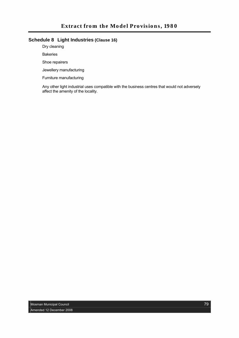
Extract from the Model Provisions, 1980
Mosman Municipal Council 79
Amended 12 December 2008
Schedule 8 Light Industries (Clause 16) Dry cleaning
Bakeries
Shoe repairers
Jewellery manufacturing
Furniture manufacturing
Any other light industrial uses compatible with the business centres that would not adversely affect the amenity of the locality.

Extract from the Model Provisions, 1980
Mosman Municipal Council 80
Amended 12 December 2008
Land used for commercial or industrial purposes
12 (1) This clause shall apply to all land having a frontage to a main or arterial road used or to be used for commercial or industrial purposes, whether or not it forms the site of a building.
(2) If -
(a) there is no building on the land or the only building thereon is of a minor character - the land; or
(b) the land forms the site of a building other than one of a minor character - the land between the road frontage and the buildings, shall not be used for the storage, sale or display of goods or for advertising purposes without the consent of the consent authority.
Service stations or car repair stations
19 A building or work shall not be erected or used and land shall not be used for the purpose of a service station unless -
(a) the site is more than 90 metres from the junction or intersection of a main or arterial road, with another main or arterial road;
(b) where the site has frontage to a main or arterial road –
(i) the Traffic Authority of New South Wales has been consulted; and
(ii) where the site is not a corner lot, the frontage to the road is not less than 38 metres, or, where the site is a corner lot, the frontage to the road is not less than 30 metres;
(c) where the site has frontage to a road other than a main or arterial road, the frontage is not less than 30 metres;
(d) the width of a vehicular crossing over a footpath is not more than 9 metres;
(e) any a vehicular crossing over a footpath is not closer than 6 metres to a road intersection;
(f) separate entrances to an exits from the site are provided and those entrances and exits are separated by physical barriers constructed on the road alignment and so identified by suitable signs readily visible to persons using the adjoining road or entering;
(g) where the site is a corner lot and the council so requires, separate entrances and exits are provided to and from each of the adjoining roads and a physical barrier is erected so that a vehicle entering the site must, when leaving it, use an exit leading only to the road from which entrance was gained.
(h) inlets to bulk fuel storage tanks are so situated on the site as to ensure that tankers, while discharging fuel into such tanks, shall stand wholly within the site;
(i) fuel pumps are within the site not closer than 3 metres to the road alignment;
(j) the layout of the site is such as to facilitate the movement of vehicles entering into or leaving the site with the flow of traffic on the adjoining road;
(k) vehicular access to or from the site from or to an adjoining road is situated not less than 24 metres to any traffic lights on the roads; and

Extract from the Model Provisions, 1980
Mosman Municipal Council 81
Amended 12 December 2008
(l) the site is suitably landscaped to the satisfaction of the consent authority.
Drive-in take-away food shops
21 A drive-in take-away food shop shall not be erected or used unless the following conditions are complied with -
(a) the site area is not less than 1000 square metres;
(b) where the site has a frontage to a main or arterial road –
(i) the frontage is not less than 27 metres; and
(ii) there is provided on the site parking space for not less than 30 motor vehicles;
(c) where the site has a frontage to any other road -
(i) that frontage is not less than 21 metres; and
(ii) there is provided on the site parking space for so many motor vehicles as the consent authority may determine;
(d) and vehicle crossing is not -
(i) less than 6 metres wide;
(ii) closer than 9 metres to another vehicular crossing on the site; or
(iii) closer than 7.6 metres to a road intersection;
(e) the site is landscaped to the satisfaction of the consent authority; and
(f) not more than 2 advertising structures are displayed outside the shop.
Motor Showrooms
22 A person shall not carry out development for the purposes of a motor showroom on any land unless-
(a) where the land has a frontage to a main or arterial road, vehicular access to the site where alternative access is available is only by way of a road, other than the main or arterial road; and
(b) where the site is a corner lot, the council is satisfied that the layout and placement of caravans, boats or motor vehicles (as the case may be) will not obstruct the vision of drivers using the intersection.

Extract from the Model Provisions, 1980
Mosman Municipal Council 82
Amended 12 December 2008
Development below high water mark
31 A person shall not carry out development on any land -
(a) below high water mark;
(b) forming part of the bed of a river, creek, bay, lagoon or other natural watercourse shown uncoloured on the map; or
(c) which has been reclaimed;
without the consent of the consent authority.
Schedule 1 (to Clause 35)
Mosman Municipal Council 83
Amended 12 December 2008
1 The carrying out by persons carrying on railway undertakings on land comprised in their undertakings of -
(a) any development required in connection with the movement of traffic by rail, including the construction, reconstruction, alteration, maintenance and repair of ways, works and plant; and
(b) the erection within the limits of a railway station or buildings for any purpose,
but excluding -
(c) the construction of new railways, railway stations and bridges over roads;
(d) the erection, reconstruction and alteration of buildings for purposes other than railway undertaking purposes outside the limits of a railway station and the reconstruction or alteration so as materially to affect the design thereof of railway stations or bridges;
(e) the formation or alteration of any means of access to a road; and
(f) the erection, reconstruction and alteration of buildings for purposes other than railway purposes where such buildings have direct access to a public place.
2 The carrying out by persons carrying on public utility undertakings, being water, sewerage, drainage, electricity or gas undertakings, of any of the following development, being development required for the purpose of their undertakings, that is to say -
(a) development of any description at or below the surface of the ground;
(b) the installation of any plant inside a building or the installation or erection within the premises of a generating station or substation established before the appointed day of any plant or other structures or erections required in connection with the station or substation;
(c) the installation or erection of any plant or other structures or erections by way of addition to or replacement or extension of plant or structures or erections already installed or erected, including the installation in an electrical transmission line of substations, feeder-pillars or transformer housing, but not including the erection of overhead lines for the supply of electricity or pipes above the surface of the ground for the supply of water, or the installation of substations, feeder-pillars or transformer housings of stone, concrete or brickworks;
(d) the provision of overhead service lines in pursuance of any statutory power to provide a supply of electricity;
(e) the erection of service reservoirs on land acquired or in process of being acquired for the purpose thereof before the appointed day, provided reasonable notice of the proposed erection is given to the council; or
(f) any other development except -
(i) the erection of buildings, the installation or erection of plant or other structures or erections and the reconstruction or alteration, so as materially to affect the design or external appearance thereof, of buildings; or
(ii) the formation or alteration of any means of access to a road.
3 The carrying out by persons carrying on public utility undertakings, being water transport undertakings, or land comprised in their undertakings, of any development required in connection with the movement of traffic by water, including the construction, reconstruction, alteration, maintenance and repair of ways, buildings, wharves, works and plant required for that purpose, except –

Schedule 1 (to Clause 35)
Mosman Municipal Council 84
Amended 12 December 2008
(a) the erection of buildings and the reconstruction or alteration of buildings so as materially to affect the design or external appearance thereof; or
(b) the formation or alteration of any means of access to a road.
4 The carrying out by persons carrying on public utility undertakings, being wharf or river undertakings, on land comprised in their undertakings, of any development required for the purposes of shipping or in connection with the embarking, loading, discharging or transport of passengers, live-stock or goods at a wharf or the movement of traffic by a railway forming part of the undertaking, including the construction, reconstruction, alteration, maintenance and repair of ways, buildings, works and plant for those purposes, except -
(a) the construction of bridges, the erection of any other buildings, and the reconstruction or alteration of bridges or of buildings so as materially to affect the design or external appearance thereof; or
(b) the formation or alteration of any means of access to a road.
5 The carrying out by persons carrying on public utility undertakings, being air transport undertakings, or land comprised in their undertakings, within the boundaries of any aerodrome, of any development required in connection with the movement of traffic by air, including the construction, reconstruction, alterations, maintenance and repair of ways, buildings, wharves, works and plant required for that purpose, except -
(a) the erection of buildings and the reconstruction or alteration of buildings so as materially to affect the design or external appearance thereof; or
(b) the formation or alteration of any means of access to a road.
6 The carrying out by persons carrying on public utility undertakings, being road transport undertakings, on land comprised in their undertakings, of any development required in connection with the movement of traffic by road, including the construction, reconstruction, alteration, maintenance and repair of buildings, works and plant required for that purpose, except -
(a) the erection of buildings and the reconstruction or alteration of buildings so as materially to affect the design or external appearance thereof; or
(b) the formation or alteration of any means of access to a road.
7 The carrying out by the owner or lessee of a mine (other than a mineral sands mine), on the mine, of any development required for the purposes of a mine, except -
(a) the erection of buildings (not being plant or other structures or erections required for the mining, working, treatment or disposal of minerals) and the reconstruction, alteration or extension of buildings, so as materially to affect the design or external appearance thereof; or
(b) the formation of any means of access to a road.
8 The carrying out of any development required in connection with the construction, reconstruction, improvement, maintenance or repair of any road, except the widening, realignment or relocation of such road.
9 The carrying out of any forestry work by the Forestry Commission, School Forest Trust or Community Forest Authorities empowered under relevant Acts to undertake afforestation, roading, protection, cutting and marketing of timber, and other forestry purposes under such Acts or upon any Crown land temporarily reserved from sale as a timber reserve under the Forestry Act, 1916.
10 The carrying out by a Pastures Protection Board of any development required for the improvement and maintenance of travelling stock and water reserves, except -

Schedule 1 (to Clause 35)
Mosman Municipal Council 85
Amended 12 December 2008
(i) the erection of buildings and the reconstruction or alteration of buildings so as materially to affect the design or purpose thereof;
(ii) any development designed to change the use or purpose of any such reserve.
11 The carrying out or causing to be carried out by a council engaged in flood mitigation works or by the Water Resources Commission of any work for the purposes of soil conservation, irrigation, afforestation, reafforestation, flood mitigation, water conservation or river improvement in pursuance of the provisions of the Water Act, 1912, the Irrigation Act, 1912, the Farm Water Supplies Act, 1946, or the Rivers and Foreshores Improvement Act, 1948, except -
(i) the erection of buildings, the installation or erection of plant or other structures or erection and the reconstruction or alteration of buildings so as materially to affect the design or external appearance thereof;
(ii) the formation or alteration of any means of access to a road.

SYDNEY REGIONAL ENVIRONMENTAL PLAN NO. 23 ANNEXURE SYDNEY AND MIDDLE HARBOURS General Aims of the Plan
Mosman Municipal Council 86
Amended 12 December 2008
(a)
to establish a framework which encourages a consistent and co-ordinated approach to the planning, development and management of the waterway, islands and foreshores of Sydney and Middle Harbours; and
(b) to establish an efficient and effective development control system for the Harbours and their foreshores and islands; and
(c) to ensure that the Harbours and their foreshores are developed and promoted as a community asset, with due recognition being given to their role as a recreation and tourist focal point; and
(d) to ensure that the special value of certain foreshore areas as access points to the waterway are fully considered in future planning and development control; and
(e) to recognise, protect and enhance the natural, scenic, environmental, cultural and heritage qualities of the land to which this plan applies in future planning and development control; and
(f) to ensure that appropriate facilities are provided for water based and foreshore recreational activities which are compatible with the commercial role of the Port of Sydney and give due regard to the environmental and cultural attributes; and
(g) to encourage balanced multiple use of the Harbours and their foreshores, in a manner that is consistent with their environmental and cultural attributes and the commercial functions of the Port of Sydney; and
(h) to ensure that consistent guidelines are applied to the assessment of development of the Harbours and their foreshores and islands; and
(i) to encourage an appreciation of the Harbours and their foreshores and islands as areas of outstanding heritage significance and, in particular, the significance of individual heritage items within those areas; and
(j) to encourage an appreciation of the remaining natural foreshores around the Harbours.


