MORPHOLOGICAL TYPIFICATIONS OF SLOVENIA’S...
12
MORPHOLOGICAL TYPIFICATIONS OF SLOVENIA’S SURFACE USING GLOBAL CLASSIFICATION METHODS AUTHORS Mauro Hrvatin, Drago Perko Scientific Research Centre of the Slovenian Academy of Sciences and Arts, Anton Melik Geographical Institute, Gosposka ulica 13, SI – 1000 Ljubljana, Slovenia [email protected], [email protected] UDC: 911.2:551.43(497.4) COBISS: 1.01 ABSTRACT Morphological typifications of Slovenia’s surface using global classification methods Morphology is often the most important factor in distinguishing landscapes and is an important element in geographical classifications, typifications, and regionalizations. Therefore, morphological divisions of the surface have a long tradition in Slovenia and abroad. The development of geographic information sys- tems has significantly increased the number of methods and indicators used for determining, analyzing, and classifying morphological units at various size levels. In terms of spatial combinations, one distinguishes between continuous and discontinuous surface classifications, and between global and regional surface classifications in terms of the values and value limits of indicators. This article presents examples of for- eign methods of global surface classification of Slovenia and compares them to the established Slovenian typification of Slovenia’s surface. KEY WORDS geomorphology, relief, surface, continuous and discontinuous surface classification method, global and region- al surface classification method, digital elevation model, geographic information system, Slovenia IZVLEČEK Morfološke tipizacije površja Slovenije z globalnimi metodami Oblikovanost površja je pogosto najpomembnejši dejavnik razlikovanja med pokrajinami in pomembna prvina pri geografskih klasifikacijah, tipizacijah in regionalizacijah, zato imajo morfološke delitve površja v tujini in pri nas že dolgo tradicijo. Z razvojem geografskih informacijskih sistemov se je močno povečalo število metod in kazalnikov za določanje, analizo in razvrščanje enot oblikovanosti površja na različnih velikostnih ravneh. Glede na prostorsko združevanje lahko ločimo zvezne in nezvezne delitve površja, glede na vrednosti in meje vrednosti kazalnikov pa globalne in regionalne delitve površja. V prispevku predstavljamo primere tujih metod globalne delitve površja Slovenije in jih primerjamo z uveljavljeno slovensko tipizacijo površja Slovenije. KLJUČNE BESEDE geomorfologija, relief, površje, metoda zvezne in nezvezne delitve površja, metoda globalne in regionalne delitve površja, digitalni model višin, geografski informacijski sistem, Slovenija The article was submitted for publication on July 12, 2011. 39 Geografski vestnik 84-1, 2012, 39–50 Articles ARTICLES
Transcript of MORPHOLOGICAL TYPIFICATIONS OF SLOVENIA’S...

MORPHOLOGICAL TYPIFICATIONS OF SLOVENIA’S SURFACEUSING GLOBAL CLASSIFICATION METHODSAUTHORSMauro Hrvatin, Drago PerkoScientific Research Centre of the Slovenian Academy of Sciences and Arts, Anton Melik Geographical Institute,Gosposka ulica 13, SI – 1000 Ljubljana, [email protected], [email protected]
UDC: 911.2:551.43(497.4)COBISS: 1.01
ABSTRACTMorphological typifications of Slovenia’s surface using global classification methodsMorphology is often the most important factor in distinguishing landscapes and is an important elementin geographical classifications, typifications, and regionalizations. Therefore, morphological divisions ofthe surface have a long tradition in Slovenia and abroad. The development of geographic information sys-tems has significantly increased the number of methods and indicators used for determining, analyzing,and classifying morphological units at various size levels. In terms of spatial combinations, one distinguishesbetween continuous and discontinuous surface classifications, and between global and regional surfaceclassifications in terms of the values and value limits of indicators. This article presents examples of for-eign methods of global surface classification of Slovenia and compares them to the established Sloveniantypification of Slovenia’s surface.
KEY WORDSgeomorphology, relief, surface, continuous and discontinuous surface classification method, global and region-al surface classification method, digital elevation model, geographic information system, Slovenia
IZVLEČEKMorfološke tipizacije površja Slovenije z globalnimi metodamiOblikovanost površja je pogosto najpomembnejši dejavnik razlikovanja med pokrajinami in pomembnaprvina pri geografskih klasifikacijah, tipizacijah in regionalizacijah, zato imajo morfološke delitve površjav tujini in pri nas že dolgo tradicijo. Z razvojem geografskih informacijskih sistemov se je močno povečaloštevilo metod in kazalnikov za določanje, analizo in razvrščanje enot oblikovanosti površja na različnihvelikostnih ravneh. Glede na prostorsko združevanje lahko ločimo zvezne in nezvezne delitve površja, glede navrednosti in meje vrednosti kazalnikov pa globalne in regionalne delitve površja. V prispevku predstavljamoprimere tujih metod globalne delitve površja Slovenije in jih primerjamo z uveljavljeno slovensko tipi zacijopovršja Slovenije.
KLJUČNE BESEDEgeomorfologija, relief, površje, metoda zvezne in nezvezne delitve površja, metoda globalne in regionalnedelitve površja, digitalni model višin, geografski informacijski sistem, Slovenija
The article was submitted for publication on July 12, 2011.
39
Geografski vestnik 84-1, 2012, 39–50 Articles
ARTICLES

1 Introduction
Morphology is often the most important factor in distinguishing between landscapes and an impor-tant element in geographical classifications, typifications, and regionalizations. Therefore, morphologicalclassifications of the surface have a long tradition in Slovenia and abroad. The development of geo-graphic information systems has significantly increased the number of methods and indicators usedfor determining, analyzing, and classifying morphological units at various size levels.
The former tedious and time-consuming landform classifications based on maps have been replacedby faster and more accurate classifications using computer-supported geographic information systems.These types of classifications are more objective, even though the selection of classification elements andtheir classes remain subjective. Iwahashi and Pike (2006) prepared an overview of 12 landform classi-fications that have been published in recent years and all of them were developed electronically.
Slovenia has an extremely varied relief and can thus serve as a good indicator of the effectivenessor suitability of individual methods and indicators used in landform classification.
2 Global, non-global, continuous, and discontinuous landform classifications
In terms of spatial combinations, one distinguishes between continuous and discontinuous land-form classifications, and between global and regional surface classifications in terms of the values andvalue limits of indicators.
Landform classification may be continuous or discontinuous. Classification and typification maybe either continuous or discontinuous, but it is more common for classification to be continuous andtypification discontinuous; regionalization is always discontinuous.
In discontinuous landform classification, individual parts of the surface are combined into areaswith the same or similar values of selected relief indicators and clear borders with adjacent areas withdifferent values of selected relief indicators. These areas can be referred to as units. Areas with the sameor similar values of relief indicators may appear several times in the landscape studied, but they areseparated from one another by areas with different values of relief indicators.
In continuous landform classification, individual parts of the surface are classified only based onthe values of selected relief indicators, regardless of their spatial position. These non-spatial units aremost commonly referred to as classes. Parts of the surface are thus not necessarily connected or do nottouch one another, and they can appear anywhere in the landscape studied.
Discontinuous classification is more qualitative, is based on expert knowledge, and has greater appliedvalue; however, it is more subjective. Continuous classification is more quantitative and objective, andhas greater analytical value. Continuous landform classification is often only the first stage of discon-tinuous classification – or, in other words: discontinuous classification is usually an improvedcontinuous landform classification.
In older landform classifications used in Slovenia and elsewhere, discontinuous classifications pre-dominated; however, after the introduction of computers and geographic information systems, continuousclassifications and combinations of continuous and discontinuous classifications prevailed.
If a landform classification uses the same values and value limits of selected relief indicators as are usedfor the entire world, this is referred to as the global landform classification method. If their values and valuelimits are adjusted to individual areas, this is referred to as the regional landform classification method.
The advantages of the global classification method is that it makes it possible to compare all partsof the world and the advantage of the regional classification method is that internal differences can beshown even in those parts of the world that would remain completely unclassified under the global clas-sification method; this can be achieved by adjusting the values and value limits of relief indicators tode-facto conditions in the selected landscape.
40
Mauro Hrvatin, Drago Perko Morphological typifications of Slovenia’s surface using global …
In Slovenian and international classifications, typifications, and regionalizations, the global land-form classification methods or adjusted global classification methods prevail; the use of the regionallandform classification method, which in itself contains elements of adaptation to various landscapes,is very rare. Adjusted global landform classification methods thus represent a type of intermediate solu-tion between global and regional landform classifications.
3 Hammond
One of the first and best-known morphological typifications was developed by the American geo-grapher Edwin H. Hammond, who classified the land-surface forms of the U.S. in greater detail(Hammond 1964). Later on, his method was reused several times using the geographic informationsystem and the digital elevation model (Dikau, Brabb, and Mark 1991; Brabyn 1998; Gallant, Douglas,and Hoffer 2005).
Hammond used a square cell with a baseline of 6 miles (approximately 9.65 km and an area of93.12 km2) as the basic surface unit for calculating relief elements; this may seem enormous, but in theU.S. context this does not even account for 0.001% of its entire territory. The cells followed one anoth-er without overlapping. Using 1 : 250,000 maps, he defined the following three elements for each cell:slope, local relief, and profile type. He labeled each element with an agreed-upon sign and used theircombinations to determine the land-surface form units.
The first element in Hammond’s classification is slope. For each cell, he calculated what share ofits area has a slope below 8% (approximately 4.57°). He labeled this element with capital letters:• A: > 80% of area gently sloping,• B: 50–80% of area gently sloping,• C: 20–50% of area gently sloping,• D: < 20% of area gently sloping.
The second element in Hammond’s classification is local relief. He defined the maximum and min-imum elevation and their difference for each cell. He labeled this element with numerals:• 1: 0–30 m,• 2: 30–90 m,• 3: 90–150 m,• 4: 150–300 m,• 5: 300–900 m,• 6: 900–1,500 m.
The third element in Hammond’s classification is profile type. For each cell he defined the percentageof gently inclined surface that lies below or above the average local relief of the cell. He labeled this ele-ment with lower-case letters:• a: > 75% of gentle slope is in lowland,• b: 50–75% of gentle slope is in lowland,• c: 50–75% of gentle slope is on upland,• d: > 75% of gentle slope is on upland.
Hammond combined these elements to define the land-surface forms. He drew them onto a large colormap at a scale of 1 : 5,000,000. However, he did not present the results of his classification in square form,but with the land-form boundaries that he set subjectively by following the edges of flat plains, tablelands,hills, and similar major relief forms. Because of this the map is slightly generalized, but more synoptic.
To define the landform units, Hammond used three elements with four (slope), six (local relief),and another four (profile type) classes; this theoretically makes up 96 combinations or 96 possible land-form units. However, he actually only chose 21 units, which he combined into five groups (plains,tablelands, plains with hills or mountains, open hills and mountains, and hills and mountains).
41
Geografski vestnik 84-1, 2012 Articles

Only 13 of his 21 landform units (morphological types) appear in Slovenia (Table 1, Figure 1).
Table 1: Morphological types of Slovenia according to Hammond.
Unit km2 %
1 Flat plains 99.83 0.492 Smooth plains 93.40 0.463 Tablelands with moderate relief 1.93 0.014 Plains with hills 609.21 3.015 Plains with high hills 1,102.06 5.446 Plains with low mountains 1,371.04 6.767 Open hills 141.44 0.708 Open high hills 819.23 4.049 Open low mountains 3,990.24 19.68
10 Open high mountains 411.04 2.0311 High hills 147.23 0.7312 Low mountains 6,003.36 29.6113 High mountains 5,482.92 27.05
4 Meybeck, Green and Vörösmarty
The classification by Meybeck, Green, and Vörösmarty (2001) is the simplest of all the ones pre-sented because the authors only used two classification elements: relief roughness and mean elevation.They used the global digital elevation model GTOPO30 with 30 arc seconds grid resolution, which cor-responds to approximately 1 km.
The first element used in the classification by Meybeck, Green, and Vörösmarty is relief roughness.They defined the maximum and minimum elevation for each cell and divided their difference by thecell’s baseline length. The unit of relief roughness calculated this way is 1 m/km or ‰. They dividedthe values estimated into seven classes:• 1: < 5‰,• 2: 5–10‰,• 3: 10–20‰,• 4: 20–40‰,• 5: 40–80‰,• 6: 80–160‰,• 7: > 160‰.The second classification element is the average elevation. The values estimated were divided into eight classes:• 1: 0–200 m,• 2: 200–500 m,• 3: 500–1,000 m,• 4: 1,000–2,000 m,• 5: 2,000–3,000 m,• 6: 3,000–4,000 m,• 7: 4,000–5,000 m,• 8: 5,000–6,000 m.
42
Mauro Hrvatin, Drago Perko Morphological typifications of Slovenia’s surface using global …
Figure 1: Morphological typification of Slovenia according to Hammond. p

43
Geografski vestnik 84-1, 2012 Articles
JA
D
R
A
N
S K
O
M
O
R
J E
Cer
kno
Kra
njsk
a G
ora
Moz
irje
Boh
injs
ka B
istr
ica
Bov
ec
Cer
knic
a
Dra
vogr
ad
Gor
nja
Rad
gona
Ilirs
ka B
istr
ica
La{k
o
Lena
rtv
Slo
vens
kih
goric
ahLe
ndav
a
Ljut
omer
Met
lika
Orm
o`
Pira
n
Rad
lje o
b D
ravi
^rn
ana
Kor
o{ke
m
Rib
nica
Ru{
e
Se`
ana
Slo
vens
keK
onjic
e
Rog
a{ka
Sla
tina
Tolm
in
Treb
nje
Tr`i
~
@el
ezni
ki
@iri
[en
tjur
Ajd
ov{~
ina
Bre
`ice
^rn
omel
j
Gro
supl
je
Hra
stni
k
Idrij
a
Kam
nik
Ko~
evje
Kr{
ko
Litij
a
Loga
tec
Pos
tojn
a
Ble
d
Rad
ovlji
ca
Rav
nena
Kor
o{ke
m
Sev
nica
Slo
venj
Gra
dec
Slo
vens
ka B
istr
ica
Vrh
nika
Zag
orje
ob
Sav
i
@al
ecC
elje
Do
m`a
le
Izo
la
Jese
nic
e
Ko
per
Kra
nj
Mu
rska
So
bo
ta
No
va G
ori
ca
No
vo m
esto
Ptu
j
[ko
fja
Lo
kaTr
bo
vlje
Vel
enje
LJU
BL
JAN
A
MA
RIB
OR
Reka
Mir
na
Pivka
Idrij
ca
Sotla
Savinja
Dra
vinj
a
Dra
gon
ja
Vip
ava
Me`
a
Pesnica[~a
vnic
a
Ledava
Sora Lj
ublja
nica
Savi
nja
Kolpa
Krka
So~a
Sava
Sava
Dra
va
Mur
a
Au
tho
rs:M
auro
Hrv
atin
,Dra
go P
erko
010
2030
4050
km
Car
tog
rap
hy:
Dra
go P
erko
,Mau
ro H
rvat
in
Flat
pla
ins
Smoo
th p
lain
s
Tabl
elan
ds w
ith
mod
erat
e re
lief
Pla
ins
wit
h h
ills
Pla
ins
wit
h h
igh
hill
s
Pla
ins
wit
h lo
w m
oun
tain
sO
pen
hill
s
Op
en h
igh
hill
s
Op
en lo
w m
oun
tain
s
Op
en h
igh
mou
nta
ins
Hig
h h
ills
Low
mou
nta
ins
Hig
h m
oun
tain
s
Un
its
©Z
RC
SA
ZU
GIA
M

Meybeck, Green, and Vörösmarty combined these elements to define 15 landform units, of which13 also appear in Slovenia. The typification of Slovenia’s surface, which was performed as part of thetypification of the surface of the entire world following the methodology developed by Meybeck, Green,and Vörösmarty, was taken from the website of the Institute for Environment and Sustainability, whichis part of the European Commission Joint Research Centre (Internet 1).
Table 2: Morphological types of Slovenia according to Meybeck, Green, and Vörösmarty.
Unit km2 %
1 Plains 1,063.04 5.242 Mid Altitude Plains 1,723.99 8.503 High Altitude Plains 145.31 0.724 Lowlands 580.66 2.865 Rugged Lowlands 66.96 0.336 Very Low Plateaus 5,514.21 27.207 Low Plateaus 2,554.05 12.608 Mid Altitude Plateaus 305.83 1.519 High Altitude Plateaus 10.15 0.05
10 Hills 1,904.12 9.3911 Low Altitude Mountains 4,529.24 22.3412 Mid Altitude Mountains 1,815.29 8.9513 High Altitude Mountains 60.10 0.30
5 Iwahashi and Pike
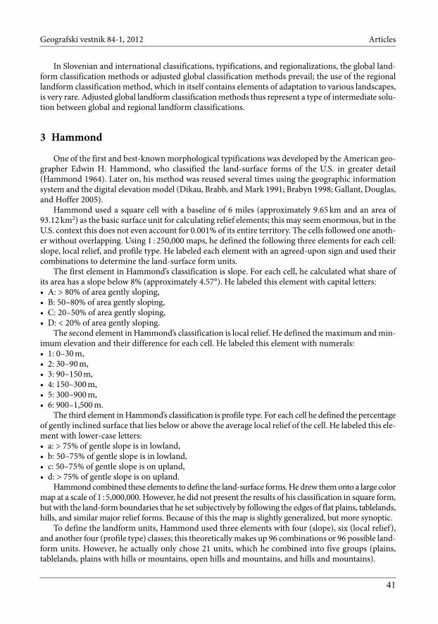
Iwahashi and Pike (2007) developed their landform classification in three areas of various size usingthree different digital elevation models. Their landform classification of a part of Hokkaido was basedon a 55-meter digital elevation model, their classification of Japan was based on a 270-meter digitalelevation model, and their classification of the world was based on a 1,000-meter digital elevation model.
They used the same criteria in all of their classifications:• Slope gradient,• Local convexity,• Surface texture.
They calculated slope gradient with ArcGIS, which uses Horn’s algorithm (1981). They determinedlocal convexity using the highly permeable Laplacian filter for detecting edges, which is similar to themathematical operation of the second derivative. This filter enhances the edges in all directions andthus the basic features of landforms such as the bottoms of valleys and the peaks of ridges. They deter-mined the surface texture so that they first calculated the median of every cell using a 9-cell movingwindow (3 × 3 cells). Then they subtracted the layer with the median values from the original digitalelevation model and thus gained a layer in which the peaks of ridges and the bottoms of valleys werethe most pronounced. From the geomorphological viewpoint, this layer could be named the map ofdensity of valleys and ridges. At the same time, this layer shows the terrain or the surface texture. Infurther developing the surface texture indicator, they took into account all of the positive and nega-tive cells and ascribed them the value 1; all the other cells retained the value 0. Then they used a round
44
Mauro Hrvatin, Drago Perko Morphological typifications of Slovenia’s surface using global …
Figure 2: Morphological typification of Slovenia according to Meybeck, Green, and Vörösmarty. p

45
Geografski vestnik 84-1, 2012 Articles
JA
D
R
A
N
S K
O
M
O
R
J E
Cer
kno
Kra
njsk
a G
ora
Moz
irje
Boh
injs
ka B
istr
ica
Bov
ec
Cer
knic
a
Dra
vogr
ad
Gor
nja
Rad
gona
Ilirs
ka B
istr
ica
La{k
o
Lena
rtv
Slo
vens
kih
goric
ahLe
ndav
a
Ljut
omer
Met
lika
Orm
o`
Pira
n
Rad
lje o
b D
ravi
^rn
ana
Kor
o{ke
m
Rib
nica
Ru{
e
Se`
ana
Slo
vens
keK
onjic
e
Rog
a{ka
Sla
tina
Tolm
in
Treb
nje
Tr`i
~
@el
ezni
ki
@iri
[en
tjur
Ajd
ov{~
ina
Bre
`ice
^rn
omel
j
Gro
supl
je
Hra
stni
k
Idrij
a
Kam
nik
Ko~
evje
Kr{
ko
Litij
a
Loga
tec
Pos
tojn
a
Ble
d
Rad
ovlji
ca
Rav
nena
Kor
o{ke
m
Sev
nica
Slo
venj
Gra
dec
Slo
vens
ka B
istr
ica
Vrh
nika
Zag
orje
ob
Sav
i
@al
ecC
elje
Do
m`a
le
Izo
la
Jese
nic
e
Ko
per
Kra
nj
Mu
rska
So
bo
ta
No
va G
ori
ca
No
vo m
esto
Ptu
j
[ko
fja
Lo
kaTr
bo
vlje
Vel
enje
LJU
BL
JAN
A
MA
RIB
OR
Reka
Mir
na
Pivka
Idrij
ca
Sotla
Savinja
Dra
vinj
a
Dra
gon
ja
Vip
ava
Me`
a
Pesnica[~a
vnic
a
Ledava
Sora Lj
ublja
nica
Savi
nja
Kolpa
Krka
So~a
Sava
Sava
Dra
va
Mur
a
©Z
RC
SA
ZU
GIA
M
Au
tho
rs:M
auro
Hrv
atin
,Dra
go P
erko
010
2030
4050
km
Car
tog
rap
hy:
Dra
go P
erko
,Mau
ro H
rvat
in
Pla
ins
Mid
Alt
itu
de P
lain
sH
igh
Alt
itu
de P
lain
s
Low
lan
dsR
ugg
ed L
owla
nds
Ver
y Lo
w P
late
aus
Low
Pla
teau
s
Mid
Alt
itu
de P
late
aus
Hig
hA
ltit
ude
Pla
teau
s
Hill
s
Low
Alt
itu
de M
oun
tain
s
Mid
Alt
itu
de M
oun
tain
sH
igh
Alt
itu
de M
oun
tain
s
Un
its

moving window with a diameter of 10 cells to determine the frequency of the terrain. This data finalyenabled them to calculate the percentage of terrain occurrence for each cell by dividing the frequen-cy of occurrence by the area of the round moving window.
Iwahashi and Pike connected the prepared classification layers (slope gradient, local convexity, and sur-face texture) using the nested-means classification procedure, which was introduced to geographical researchand classification by Scripter (1970) and makes it possible to divide the surface into 8, 12, or 16 classes.
This procedure is especially recommended for dividing unevenly or asymmetrically classified datasuch as data on the elevation and slope gradient, in which greater values are increasingly rarer.
The typification of Slovenia’s surface made following Iwahashi’s and Pike’s methodology as part ofthe typification of the entire world’s surface was based on the website of the Geospatial InformationAuthority of Japan (Internet 2).
Of the 16 landform units defined by Iwahashi and Pike in their classification of the world surface,13 appear in Slovenia (Table 3, Figure 3).
Table 3: Morphological types of Slovenia according to Iwahashi and Pike.
Unit km2 %
1 Gentle surface with low convexity and coarse texture 190.03 0.942 Gentle surface with low convexity and fine texture 574.63 2.833 Gentle surface with high convexity and fine texture 59.83 0.304 Moderately gentle surface with low convexity and coarse texture 44.13 0.225 Moderately gentle surface with low convexity and fine texture 925.44 4.566 Moderately gentle surface with high convexity and fine texture 245.37 1.217 Moderately steep surface with low convexity and coarse texture 80.25 0.408 Moderately steep surface with low convexity and fine texture 3,060.27 15.109 Moderately steep surface with high convexity and fine texture 1,720.62 8.49
10 Steep surface with low convexity and coarse texture 95.61 0.4711 Steep surface with low convexity and fine texture 5,599.23 27.6212 Steep surface with high convexity and coarse texture 10.05 0.0513 Steep surface with high convexity and fine texture 7,667.47 37.82
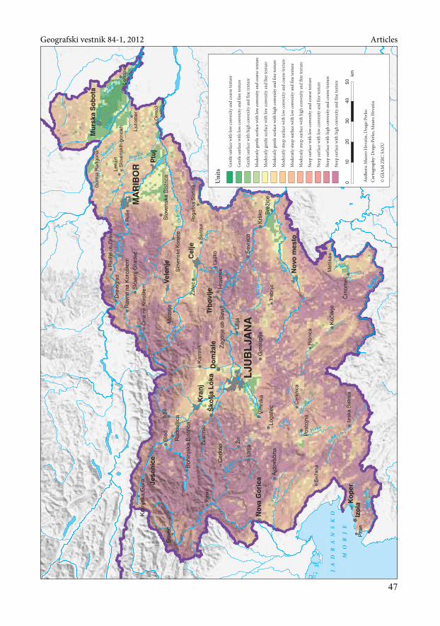
6 Perko
The first computerized relief typification in Slovenia was created by Drago Perko, who initially divid-ed Slovenian territory into eight landform units (Perko 1992; 2001; 2007), and later on into seven (Table 4,Figure 4).
This classification is based on spatial variability in elevation and slope. For each square cell ofa 100-meter digital elevation model, Perko took into account its eight neighboring cells (a moving win-dow measuring 9 ha or 3 × 3 cells) to first calculate the elevation variation and the slope variationcoefficient; following this, he used both variation coefficients to calculate their geometric mean, whichhe called the relief coefficient (Perko 2001). By generalizing the relief coefficient, he defined the land-form units. He manually adjusted the final borders between these units to the natural borders in thelandscape (rivers, plateau edges, etc.).
Later he determined the variability of Slovenia’s relief (Perko 2007) using a new version of the reliefcoefficient, which he calculated as a geometric mean of the slope variation coefficient and the aspect
46
Mauro Hrvatin, Drago Perko Morphological typifications of Slovenia’s surface using global …
Figure 3: Morphological typification of Slovenia according to Iwahashi and Pike. p
47
Geografski vestnik 84-1, 2012 Articles
JA
D
R
A
N
S K
O
M
O
R
J E
Cer
kno
Kra
njsk
a G
ora
Moz
irje
Boh
injs
ka B
istr
ica
Bov
ec
Cer
knic
a
Dra
vogr
ad
Gor
nja
Rad
gona
Ilirs
ka B
istr
ica
La{k
o
Lena
rtv
Slo
vens
kih
goric
ahLe
ndav
a
Ljut
omer
Met
lika
Orm
o`
Pira
n
Rad
lje o
b D
ravi
^rn
ana
Kor
o{ke
m
Rib
nica
Ru{
e
Se`
ana
Slo
vens
keK
onjic
e
Rog
a{ka
Sla
tina
Tolm
in
Treb
nje
Tr`i
~
@el
ezni
ki
@iri
[en
tjur
Ajd
ov{~
ina
Bre
`ice
^rn
omel
j
Gro
supl
je
Hra
stni
k
Idrij
a
Kam
nik
Ko~
evje
Kr{
ko
Litij
a
Loga
tec
Pos
tojn
a
Ble
d
Rad
ovlji
ca
Rav
nena
Kor
o{ke
m
Sev
nica
Slo
venj
Gra
dec
Slo
vens
ka B
istr
ica
Vrh
nika
Zag
orje
ob
Sav
i
@al
ecC
elje
Do
m`a
le
Izo
la
Jese
nic
e
Ko
per
Kra
nj
Mu
rska
So
bo
ta
No
va G
ori
ca
No
vo m
esto
Ptu
j
[ko
fja
Lo
kaTr
bo
vlje
Vel
enje
LJU
BL
JAN
A
MA
RIB
OR
Reka
Mir
na
Pivka
Idrij
ca
Sotla
Savinja
Dra
vinj
a
Dra
gon
ja
Vip
ava
Me`
a
Pesnica[~a
vnic
a
Ledava
Sora Lj
ublja
nica
Savi
nja
Kolpa
Krka
So~a
Sava
Sava
Dra
va
Mur
a
Au
tho
rs:M
auro
Hrv
atin
,Dra
go P
erko
010
2030
4050
km
Car
tog
rap
hy:
Dra
go P
erko
,Mau
ro H
rvat
in
Gen
tle s
urfa
ce w
ith
low
con
vexi
ty a
nd c
oars
e te
xtur
e
Gen
tle s
urfa
ce w
ith
low
con
vexi
ty a
nd fi
ne te
xtur
e
Gen
tle s
urfa
ce w
ith
high
con
vexi
ty a
nd fi
ne te
xtur
e
Mod
erat
ly g
entle
sur
face
wit
h lo
w c
onve
xity
and
coa
rse
text
ure
Mod
erat
ly g
entle
sur
face
wit
h lo
w c
onve
xity
and
fine
text
ure
Mod
erat
ly g
entle
sur
face
wit
h hi
gh c
onve
xity
and
fine
text
ure
Mod
erat
ly s
teep
sur
face
wit
h lo
w c
onve
xity
and
coa
rse
text
ure
Mod
erat
ly s
teep
sur
face
wit
h lo
w c
onve
xity
and
fine
text
ure
Mod
erat
ly s
teep
sur
face
wit
h hi
gh c
onve
xity
and
fine
text
ure
Stee
p su
rfac
e w
ith
low
con
vexi
ty a
nd c
oars
e te
xtur
e
Stee
p su
rfac
e w
ith
low
con
vexi
ty a
nd fi
ne te
xtur
e
Stee
p su
rfac
e w
ith
high
con
vexi
ty a
nd c
oars
e te
xtur
e
Stee
p su
rfac
e w
ith
high
con
vexi
ty a
nd fi
ne te
xtur
e
Un
its
©Z
RC
SA
ZU
GIA
M

variation coefficient of each square cell of the 25-meter digital elevation model and its 120 neighbors(a moving window measuring 75,625 ha or 11 × 11 cells).
Table 4: Morphological types of Slovenia according to Perko.
Unit km2 %
1 Plains 1,918.31 9.462 Rough Plains 1,195.38 5.903 Low Hills 4,842.91 23.894 Rough Low Hills 2,645.48 13.055 High Hills 6,686.63 32.986 Rough High Hills 1,028.94 5.087 Mountains 1,955.29 9.64
7 Conclusion
Various surface classifications are more or less successful in dividing Slovenia’s surface. Themajority show Slovenia as a hilly or even mountainous country with a diverse relief. Some areas areplaced in classes that deviate considerably from the actual conditions. The classification criteria haveobviously been adjusted to areas with less diverse relief, such as the North European Plain, the WestSiberian Plain, and the Tibetan Plateau. However, with appropriate modification of the classificationcriteria (Perko and Hrvatin 2009) the same classifications yield significantly better results even for coun-tries with such a diverse relief as Slovenia.
Hammond’s method proved to be of relatively good quality in classifying the surface of the UnitedStates. However, for Slovenia, where the morphological features of the surface change rapidly in space, thismethod is insufficiently accurate. Thus a number of Slovenian landscapes are classified in units that donot show their actual morphological features because, due to the size of the basic square cell, the morphologicalfeatures of their neighboring landscapes are also taken into account. The original basic cell with an areaof nearly 100 km2 is significantly too large to determine all three of Hammond’s elements for Slovenia.
The results of Meybeck, Green, and Vörösmarty’s method are the closest to our idea of Slovenia’slandforms. Among all three foreign methods selected, it is the only one that does not require majoradjustments. However, as in practically all computerized surface classifications, individual relief unitsare spatially too fragmented.
Of the 16 classes in the original classification of the entire world’s surface following Iwahashi andPike’s method, 13 classes appear in Slovenia. The percentage of the surface covered by individual class-es is very uneven because nearly nine-tenths of Slovenian territory is classified under only four classes.The weaknesses noticed in this classification include the excessive similarity between the second andthird classification criteria (the percentage of local convexity and surface texture), which consequent-ly partly duplicate each other.
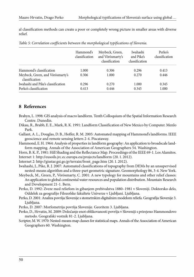
It is interesting that all three selected foreign classifications are statistically more correlated withthat of Perko (correlation coefficients between 0.345 and 0.446) than with one another (correlation coef-ficients between 0.270 and 0.306). The classification by Meybeck, Green, and Vörösmarty statisticallycorrelates the best with Perko’s classification (correlation coefficient of 0.446) (Table 5).
By comparing the units in Perko’s classification or typification with the units used by Hammond,by Meybeck, Green, and Vörösmarty, and by Iwahashi and Pike, it can be seen how the use of the glob-
48
Mauro Hrvatin, Drago Perko Morphological typifications of Slovenia’s surface using global …
Figure 4: Morphological typification of Slovenia according to Perko. p
49
Geografski vestnik 84-1, 2012 Articles
JA
D
R
A
N
S K
O
M
O
R
J E
Cer
kno
Kra
njsk
a G
ora
Moz
irje
Boh
injs
ka B
istr
ica
Bov
ec
Cer
knic
a
Dra
vogr
ad
Gor
nja
Rad
gona
Ilirs
ka B
istr
ica
La{k
o
Lena
rtv
Slo
vens
kih
goric
ahLe
ndav
a
Ljut
omer
Met
lika
Orm
o`
Pira
n
Rad
lje o
b D
ravi
^rn
ana
Kor
o{ke
m
Rib
nica
Ru{
e
Se`
ana
Slo
vens
keK
onjic
e
Rog
a{ka
Sla
tina
Tolm
in
Treb
nje
Tr`i
~
@el
ezni
ki
@iri
[en
tjur
Ajd
ov{~
ina
Bre
`ice
^rn
omel
j
Gro
supl
je
Hra
stni
k
Idrij
a
Kam
nik
Ko~
evje
Kr{
ko
Litij
a
Loga
tec
Pos
tojn
a
Ble
d
Rad
ovlji
ca
Rav
nena
Kor
o{ke
m
Sev
nica
Slo
venj
Gra
dec
Slo
vens
ka B
istr
ica
Vrh
nika
Zag
orje
ob
Sav
i
@al
ecC
elje
Do
m`a
le
Izo
la
Jese
nic
e
Ko
per
Kra
nj
Mu
rska
So
bo
ta
No
va G
ori
ca
No
vo m
esto
Ptu
j
[ko
fja
Lo
kaTr
bo
vlje
Vel
enje
LJU
BL
JAN
A
MA
RIB
OR
Reka
Mir
na
Pivka
Idrij
ca
Sotla
Savinja
Dra
vinj
a
Dra
gon
ja
Vip
ava
Me`
a
Pesnica[~a
vnic
a
Ledava
Sora Lj
ublja
nica
Savi
nja
Kolpa
Krka
So~a
Sava
Sava
Dra
va
Mur
a
Au
tho
rs:M
auro
Hrv
atin
,Dra
go P
erko
010
2030
4050
km
Car
tog
rap
hy:
Dra
go P
erko
,Mau
ro H
rvat
in
Pla
ins
Rou
gh P
lain
s
Low
Hill
sR
ough
Low
Hill
s
Hig
h H
ills
Rou
gh H
igh
Hill
s
Mou
nta
ins
Un
its
©Z
RC
SA
ZU
GIA
M
al classification methods can create a poor or completely wrong picture in smaller areas with diverserelief.
Table 5: Correlation coefficients between the morphological typifications of Slovenia.
Hammond’s Meybeck, Green, Iwahashi Perko’sclassification and Vörösmarty’s and Pike’s classification
classification classification
Hammond’s classification 1.000 0.306 0.296 0.413Meybeck, Green, and Vörösmarty’s 0.306 1.000 0.270 0.446
classificationIwahashi and Pike’s classification 0.296 0.270 1.000 0.345Perko’s classification 0.413 0.446 0.345 1.000
8 References
Brabyn, L. 1998: GIS analysis of macro landform. Tenth Colloquium of the Spatial Information ResearchCentre. Dunedin.
Dikau, R., Brabb, E. E., Mark, R. K. 1991: Landform Classification of New Mexico by Computer. MenloPark.
Gallant, A. L., Douglas, D. B., Hoffer, R. M. 2005: Automated mapping of Hammond’s landforms. IEEEgeoscience and remote sensing letters 2-4. Piscataway.
Hammond, E. H. 1964: Analysis of properties in landform geography: An application to broadscale land-form mapping. Annals of the Association of American Geographers 54. Washington.
Horn, B. K. P., 1981: Hill Shading and the Reflectance Map. Proceedings of the IEEE 69-1. Los Alamitos.Internet 1: http://eusoils.jrc.ec.europa.eu/projects/landform (20. 1. 2012).Internet 2: http://gisstar.gsi.go.jp/terrain/front_page.htm (20. 1. 2012).Iwahashi, J., Pike, R. J. 2007: Automated classifications of topography from DEMs by an unsupervised
nested-means algorithm and a three-part geometric signature. Geomorphology 86, 3-4. New York.Meybeck, M., Green, P., Vörösmarty, C. 2001: A new typology for mountains and other relief classes:
An application to global continental water resources and population distribution. Mountain Researchand Development 21-1. Bern.
Perko, D. 1992: Zveze med reliefom in gibanjem prebivalstva 1880–1981 v Sloveniji. Doktorsko delo,Oddelek za geografijo Filozofske fakultete Univerze v Ljubljani. Ljubljana.
Perko, D. 2001: Analiza površja Slovenije s stometrskim digitalnim modelom reliefa. Geografija Slovenije 3.Ljubljana.
Perko, D. 2007: Morfometrija površja Slovenije. Georitem 3. Ljubljana.Perko, D., Hrvatin, M. 2009: Določanje enot oblikovanosti površja v Sloveniji s prirejeno Hammondovo
metodo. Geografski vestnik 81-2. Ljubljana.Scripter, M.W. 1970: Nested-means map classes for statistical maps. Annals of the Association of American
Geographers 60. Washington.
50
Mauro Hrvatin, Drago Perko Morphological typifications of Slovenia’s surface using global …