MONTEREY COUNTY COASTAL SUBDIVISION ORDINANCE
141
, . i I I . MONTEREY COUNTY COASTAL SUBDIVISION ORDINANCE Approved by the Monterey County Planning Commission February 24, 1988 Adopted by the Monterey County Board of Supervisors May 3 I, 1988
Transcript of MONTEREY COUNTY COASTAL SUBDIVISION ORDINANCE
, . i
I
I
~
. MONTEREY COUNTY COASTAL
SUBDIVISION ORDINANCE
Approved by the Monterey County Planning Commission February 24, 1988 Adopted by the Monterey County Board of Supervisors May 3 I, 1988
!l
U
IJ lJ []
[J n LJ
o o o
o ,0 Q
J o o ;J i]
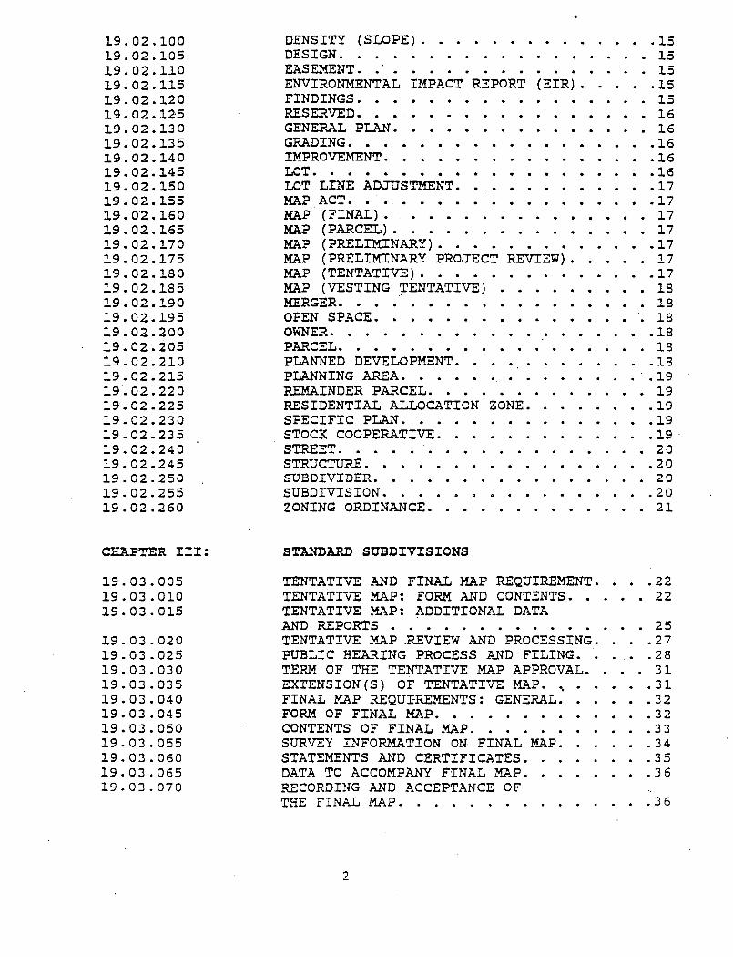
CHAPTER I:
19.01.005 19.01. 010 19.01. 015 19.01.020 19.01.025 19.01.030 19.01.035 19.01.040 19~0:t..045 19.01.050 19.01.055 19.01.060 19.01.065 19.01. 066
19.01.070
19.01.075
19.01.080
CHAPTER II:·
19.02.005 19.02.010 19.02.015 19.02.016 19.02.020 19.02.025 19.02.030 19.02.035 19.02.040 19.02.045 19.02.050 19.02.055 19.02.060 19.02.065 19.02.070 19.02.075 19.02.080 19.02.085 19.02.086 19.02.090 19.02.095
TABLE OF CONTENTS SUBDIVISION ORDINANCE
TITLE 19
GENERAL PROVISIONS
CITATION AND AUTHORITY. .1 PURPOSE. • . • • . . . . . . . • 1 CONSISTENCY. • . . . . . . . . • 2 EXCEPTIONS ........ '~ ...•.•. 2 MINOR SUBDIVISION COMMITTEE. . •• ..4 SUBDIVISION COMMITTEE ...•..•••.. 4 PLANNING COMMISSION. '0 0 •••••••• 5 BOARD OF SUPERVISORS.'., .....•.•. 6 FEES AND FORMS. . . . . . . . . . • . • 0 6 APPEALS 0 • • • • •.• • • • • 0 • • • • • .6 PUBLI C HEARINGS 0 • 0 0 • • 0 • • • • • • 0 8 APPLICABILITY. . . . . . . • . •. ..8 STATE PRE-EMPTION. . . . . . . •. ..8 COMPLIANCE WITH LOCAL, STATE AND. . FEDERAL 'LAWS. . • . . . . . • • . . . . . 8 MINOR SUBDIVISION· COMMITTEE, SUBDIVISION COMMITTEE,PLANNING COMMISSION AND BOARD OF SUPERVISORS TO CONSIDER HOUSING NEEDS OF REGION. • ....•.. 9 LIMITATION ON IMPROVEMENT REQUIREMENTS UNDER A PARCEL MAP. ........'... 9 DESIGNATED REMAINDER PARCEL IMPROVEMENT REQUIREMENTS .....•... 10
DEFINITIONS
ADVISORY AGENCY .............. 11 ADVISORY COMMITTEE. . . . . . • • . . . . 11 ALLOCATION. . _. . . . . . . . • . • . . . 11 APPROPRIATE DECISION MAKING BODY .11
'BUILDING ENVELOPE. . . . . . .11 BUILDING SETBACK LINE. . . . ... 11 BUILDING SITE.' .............. 11 CERTIFICATE OF COMPLIANCE ......... 11 CEQA. . . . . . . . . . . . . . . . . . . 12 CITIZEN'S EVALUATION COMMITTEE .•.... 12 COMMON INTEREST DEVELOPMENT ..•..... 12 COMMUN~TY APARTMENT PROJECT ........ 13 CONDOMINIUM PLAN ............. 13 COASTAL LAND USE PLAN ........... 13 COASTAL ZONE ............... 13 CONDOMINIUM PROJECT ............ 14 COUNTY. . . . . . . . . . . . . . . . 0' • 14 COMBINED DEVELOPMENT PERMIT.. . ... 14 DEVELOPMENT. . .. ... . . . .15 DENSITY. . . .. ... .15 DENSITY (GROSS). . ... 15
1
19.02.100 19.02.105 19.02.110 19.02.115 19.02.120 19.02.125 19.02.130 19.02.135 19.02.140 19.02.145 19.02.150 19.02.155 19.0'2.160 19.02.165 19.02.170 19.02.175 19.02.180 19.02.185 19.02.190 19.02.195 19.02.200 19.02.205 19.02.210 19.02.215 19.02.220 19.02.225 19.02.230 19.02.235 19.02.240 19.02.245 19.02.250 19.02.255 19.02.260
CHAPTER III:
19.03.005 19.03.010 19.03.015
19.03.020 19.03.025 19.03.030 19.03.035 19.03.040 19.03.045 19.03.050 19.03.055 19.03.060 19.03.065 19.03.070
DENSITY (SLOPE). . . • . . . • . • . .15 DESIGN. . . . . . . . . . . . . . . . . . 15 EASEMENT. .'. . . • . . . . . . • . . . . 15 ENVIRONMENTAL IMPACT REPORT (EIR) ..•.. 15 FINDINGS. • • • •. .•... 15 RESERVED. . . . • . • • . . . . . . . • • 16 GENERAL PLAN. . • • • . . . . . . . . • . 16 GRADING. • . • • • •• . . • • . • . • 16 IMPROVEMENT. • • • .• • • • . . • . . 16 LOT. . . . • • . • •• . . • . 16 LOT LINE ADJUSTMENT.. . .•.•.•. 17 MAP ACT. • ..• . • .. . . . .17 MAP (FINAL). •••.....•.•••• 17 MAP (PARCEL). . • • . . . . • . • . . • . 17 MAp· (PRELIMINARY). . . • . . . • . • . • .17 MAP (PRELIMINARY PROJECT REVIEW) .•... 17 MAP (TENTATIVE) ..•......••... 17 MAP (VESTING ~ENTATIVE) . . . . •. . 18 MERGER. • • . • • • • • . • • • • • . • . ·18 OPEN SPACE. . . • . • . . . . . • . . .. 18 OWNER. • . • • • • • • • • • • • • • . • • 18 PARCEL. . • . . • • • . • . .' . . . . . . 18 PLANNED DEVELOPMENT ............. 18 PLANNING AREA. . • . . . . . . . . . . . .. 19 REMAINDER PARCEL. . . • . . . . . . . . . 19 RESIDENTIAL ALLOCATION ZONE .•...... 19 SPECIFIC PLAN ••............. 19 STOCK COOPERATIVE ........•.... 19· STREET. . . . . . . • . . . . . . . . . . 2 a STRUCTUR.E. • • • • . • . • . • • • • • • • 20 SUBDIVIDER. . . . . . . . . . . . . . . . 20 SUBDIVISION ...........•.... 20 ZONING ORDINANCE. . • . . . . . . . . . . 21
STANDARD SUBDIVISIONS
TENTATIVE AND FINAL MAP REQUIREMENT ..•. 22 TENTATIVE MAP: FORM AND CONTENTS •.•.. 22 TENTATIVE MAP: ADDITIONAL DATA AND REPORTS . . . • . . . . . . . . . . . 25 TENTATIVE MAP .REVIEW AND PROCESSING .... 27 PUBLIC HEARING PROCESS AND FILING •.... 28 TERM OF THE TENTATIVE MAP APPROVAL .... 31 EXTENSION(S) OF TENTATIVE MAP. ~ .31 FINAL MAP REQU~REMENTS: GENERAL. .32 FORM OF FINAL MAP. . . • . . . . .. .32 CONTENTS OF FINAL MAP. . . . . . .. .33 SURVEY INFORMATION ON FINAL MAP ...... 34 STATEMENTS AND CERTIFICATES. .35 DATA TO ACCOMPANY FINAL MAP ........ 36 RECORDING AND ACCEPTANCE OF THE FINAL MAP. . . . . . . .
2
.36
Il \J
~j
il
n n o n n
CRAPTER IV:
19.04.005 19.04.010 . 19.04.015
19.04.020
19.04.025 19.04.030 19.04.035 19.04.040 19.04'.045 19.04.050 19.04.055
19.04.060
CRAPTER V:
19.05.005' 19.05.010 19.05.015
19.05.020 19.05.025 19.05.030 19.05.035.
19.05.040
19.05.045
19.05.050 19.05.055 19.05.060 19.05.065
19.05.070, 19.05.075 19.0S.d80
CHAPTER VI:
19.06.005 19.06.010
19.06.015
19.06.020 19.06.025 19.06.030
MINOR SUBDIVISIONS
TENTATIVE AND PARCEL MAP REQUIRED ..... 38 TENTATIVE PARCEL MAP: FORM AND CONTENTS. 38 TENTATIVE PARCEL MAP APPLICATIO~; ADDITIONAL DATA AND . REPORTS .... '. . . .38 TENTATIVE PARCEL MAP REVIEW AND PROCESSING. . . . . • . . . . . . . . . . 38 PUBLIC HEARING PROCESS AND FILING ..... 38 ACTION QN TENTATIVE PARCEL MAP. . . . . . 40 TERM OF TENTATIVE PARCEL MAP APPROVAL ... 41 EXTENSION(S) OF THE TENTATIVE PARCEL MAP. 41 PARCEL MAP REQUIREMENTS: GENERAL ...... 41 Fo.RM AND CONTENTS OF PARCEL MAP. . .. .42 STATEMENTS AND CERTIFICATES. TO APPEAR ON PARCEL MAP. . . . . . . . . . . . . . .43 RECORDING AND ACCEPTANCE OF THE PARCEL MAP. '. . . . . . . . . . . . . 44
VESTING TENTATIVE MAPS
PURPOSE AND INTENT. . . . . . . . . . .. 45 TERM OF VESTED RIGHTS ....... , .. '~ .45 COMPLIANCE WITH LOCAL, STATE AND FEDERAL LAWS. . ... ' .... 46 VESTING TENTATIVE MAP NOT MANDATORY .... 46 FEES AND FORMS. . . . . . . . • ... . ' • .'-. 46 BUNK. . . . . . . . . . . . . . . . 46 VESTING TENTATIVE MAP SUBMITTAL:' FORM AND CONTENTS. 0" • • • • ••• . . .46 VESTING TENTATIVE MAP SUBMITTAL: .~ ,
ADDITIONAL DATA AND REPORTS ...... o· .49 VESTING TENTATIVE MAP: REVIEW AND PROCESSING ........... 52 FILING ......... 0 0 '.' • • • •• 53 ACTION ON VESTING TENTATIVE MAP .....• 54 EXPIRATION OF THE VESTING TENTATIVE MAP. 56 EXTENSION(S) OF APPROVAL THE VESTING TENTA.TIVE MAP. . 0 • • - 0 • • • • • 56 VESTING TENTATIVE MAP AMENDMENTS ..... 56 DUTIES OF RESPONSIBLE DEPARTMENT. . . . 0 57
. FINAL AND PARCEL MAP REQUIREMENTS. ',' .. 57
PRELIMINARY MAPS
PRELIMINARY MAPS . . . . . PRELIMINARY MAP SUBMITTAL:
.59
FORM AND CONTENTS. '. . . . PRELIMINARY MAP: ADDITIONAL
. • .59
DATA AND REPORTS. . ....... . ACTION BY THE SUBDIVISION COMMITTEE. . . ACTION BY THE PLANNING COMMISSION . . . ACTION BY THE BOARD OF SUPERVISORS .
3
.60
.61
. 61
.62
CHAPTER VII:
19.07.005
19.07.010
1.9.07.01.5
19.07.020
1.9.07.025
CHAPTER
1.9.08.005 1.9.08.010
19.08.015
VIII:
CHAPTER IX:
1.9.09.005 .1.9.09.010
1.9.09.015 19.09.020
19 .. 09.025 1.9.09.030
1.9.09.035
' .. CHAPTER X:
19.1.0.005 19.10.010 1.9.10.015 19.10.020 19.10.025 19.10.030 19.10.035 19.10.040 19.10.045 19.10.050 19.10.051
19.10.052 19.10.055
PRELIMINARY PROJECT REVIEW MAPS
PRELIMINARY PROJECT REVIEW PROCEDURE REQUIRED IN RESIDENTIAL ALLOCATION ZONES. . . . . . . ...... 63 PURPOSE OF REQUEST FOR PRELIMINARY PROJECT REVIEW. ... . . . . . . . . . . 63 PRELIMINARY PROJECT REVIEW MAP: FORM AND CONTENTS. . . . . . . . .63 PRELIMINARY PROJECT REVIEW: ADDITION~L DATA AND APPLICATION REQUIREMENTS •• • . . . . . . . . . . . 66 PRELIMINARY PROJECT REVIEW MAP REVIEW AND PROCESSING ........... 68
MODIFIC~TIONS OF CONDITIONS, REVISED TENTATIVE MAPS AND CORRECTION OF AND AMENDMENT TO RECORDED FINAL OR PARCEL MAPS
REVISION(S) TO AN APPROVED TENTATIVE MAP. 72 MODIFICATION(S) OF CONDITIONS TO AN APPROVED TENTATIVE MAP ......... 72 CORRECTION AND AMENDMENT OF RECORDED FINAL OR PARCEL MAPS ........... 73
LOT LINE ADJUSTMENTS . . LOT LINE ADJUSTMENT MAP REQUIREMENT. . ..... 76 LOT LINE ADJUSTMENT MAP SUBMITTAL: FORM AND CONTENTS. . ... . . • . . . . ... 76 LOT LINE ADJUSTMENT MAP APPLICATION. . 77 LOT LINE ADJUSTMENT: REVIEW AND PROCESSING. . . • . . . • . . • . . . 78 ACTION ON THE LOT LINE ADJUSTMENT ..... 79 TERM OF APPROVAL OF AN APPROVED . LOT LINE ADJUSTMENT. . . . . . . . . EXTENSION(S) OF THE LOT LINE ADJUSTMENT MAP APPROVAL. . .
DESIGN AND IMPROVEMENT STANDARDS
.79
.79
GENERAL REQUIREMENTS ........... 80 IMPROVEMENT PLANS ............. 80 INSTALLATION OF REQUIRED IMPROVEMENTS ..• 82 CONSTRUCTION INSPECTION .......... 82 ACCEPTANCE OF IMPROVEMENTS ........ 83 LOT DESIGN. • . . . . . . . . . . . . . . 83 PEDESTRIAN AND BICYCLE ACCESS ....... 84 CIRCULATION AND TRAFFIC .. ' ........ 84 ACCESS. . . . • . . . . . . . . .. 85 DRAINAGE. . . . . . . . . . . . . . . . . 85 PUBLIC ACCESS TO COASTLINE OR BAY SHORELINE. . . .' . .. . . . . . . 86 ACCESS TO LAKE, RIVERS AND STREAMS . . . 86 GRADING. . . . . . . . . . . . . . . . . . 87
4
PUBLIC ROAD STANDARDS ........... 88 PRIVATE ROA~ STANDARDS .......... 88 WATER SUPPLY. . . . . . . . . . . . . . . 89 SEWAGE DISPOSAL. . . . . . . . . . . . . .91 ENERGY CONSERVATION. . . . . . . . '. . . .92 MON1JMENTS. . . ..• . . . . ;, . . . . . . .93 FIRE PROTECTION .............. 95 UNDERGROUND UTILITIES. . •....... 95 RAILROAD CROSSING. . . . . . . . . . . . .96
REVER.SION TO ACREAGE
ALLOWS FOR REVERSION TO ACREAGE ...... 97 OWNERS OF RECORD MAY INITIATE PROCEEDINGS. . . . . .. . ...... 97 APPLICATION ..•.•........... 97 PUBLIC HEARING REQUIRED. . . . . .. . . . . 97 NECESSARY' FINDINGS BY THE BOARD OF SUPERVISORS ........... 97 CONDITIONS OF REVERSION. . . . . .. .98 EFFECTIVE DATE OF REVERSION. . . . . . . .9.8 RETURN OF FEES AND DEPOSIT; RELEASE OF SECURITY . . . . . . . . . . . 98 NO TAX BOND REQUIRED. .' . . . . . . . . . 98 AUTHORIZATION FOR PARCEL MAP. . . . . . . 98 MERGING AND RESUBDIVIDING WITHOUT REVERSION. . . . . . . . . . . . . . . . .99
DEDICATIONS, RESERVATIONS AND EASEMENTS
DEDICATION OF STREETS, ALLEYS AND OTHER PUBLIC RIGHTS-OF-WAY OR EASEMENTS. 100 RECREATION REQUIREMENTS .......... 100 SCHOOL FACILITIES/FEES DEDICATION. .107 TITLE .. ' .' . . . . . . . .. .107 AUTHO:RITY. . • . . . . . . . . . . 107 PURPOSE. . . . . . . . . . . . . .. . 107 REGULATIONS. . . . . ..' .. .107 GENERAL PLAN. . . . . . . . . . . . . . . 107 DEFINITIONS ............. ' ... 107. OVERCROWDING ATTENDANCE AREA. . . . . . . 109 FINDINGS' AND NOTI'CE OF OVERCROWDING IN ATTENDANCE AREAS. .. .. .. .109 FINDINGS - REQUIREMENTS .......... 109 CONCURRENCE BY COUNTY ........... 110 FINDINGS FOR DEVELOPMENT APPROVAL .... ".110 REQUIREMENTS, STANDARDS AND PROCEDURES .. 110 PAYMENT OF FEES, DEDICATION OF LAND OR DEDICATION OF FACILITIES ........ 110 PAYMENT OF FEES IN SMALL RESIDENTIAL DEVELOPMENTS. . . . . . . . . . . . . . . 111 STANDARDS FOR FEES OR LAND. . . . . . . . 111 AMOUNT FOR FEES OR LAND .......... 111 FEE REQUIRED. . . . . . . . . . . . . . . 113
.. LAND DEDICATION. . . . . . . . . . . . . .113
5
e-
------_. -------I
19.12.110 19.12.115 19.12.120 19.12.125
19.12.130 19.12.135 19.12.140 19.12.145 19.12.150
CHAPTER XIII:
19.13.005 19.13.010 19.13.015 19.13.020
CHAPTER XIV:
19.14.005 19.14.010 19.14.015 19.14.020 19.14.025 19.14.030 19.14.035 19.14.040 19.14.041 19.14.045 I.: • _ •• -::OC:;O
19.14.055
19.14.060
".
REFUNDS. . . . . . . . . . . . . . . . . . 113 SCHOOL DISTRICT SCHEDULE .. - .. . PROHIBITIONS .......... . PROHIBITION ON LEVY OF FEE OR
,DEDICATION OF LAND AFTER RECEIPT
. 114 . . . . 114
OF APPORTIONMENT.. . . . . . . . . . . . . 114 CONDITIONS OF SUBSEQUENT OVERCROWDING ... 115 USE OF FEES, LAND, AND FACILITIES ..... 115 AGREEMENT FOR FEE,DISTRIBUTION ...... 115 ACCOUNT. . . . . . . . . . . . . . . 115 TERMINATION OF DEDICATION OR FEE REQUIREMENTS. . . . ....... 115
IMPROVEMENT AGREEMENTS
IMPROVEMENT AGREEMENTS .......... 121 EXTENSION OF IMPROVEMENTS AGREEMENTS ... 122 IMPROVEMENT SECURITY REQUIRED. . . .122 RELEASE OF IMPROVEMENT SECURITIES. .123
ENFORCEMENT AND PENALTY
NO CONSTRUCTION OR USE IN VIOLATION. .125 ALL COUNTY OFFICIALS SHALL ENFORCE .... '126 CIVIL ENFORCEMENT AGAINST NUISANCE. . . . 126 EACH DAY IS A VIOLATION .......... 126 CIVIL ENF.ORCEMENT. . . . . . . . . . . . .126 PENALTY DESIGNATED. . . . . . . . . . . . 126 TRANSFERS OR CONVEYANCES IN VIOLATION ... 127 REAPPLICATION ............... 127 PARCEL LEGALITY STATUS DETERMINATION ... 127 UNCONDITIONAL CERTIFICATES OF COMPLIANCE. 128 CONDITIONAL CERTIFICATES OF COMPLIANCE .. 130 FINAL MAPS AND PARCEL MAPS CONSTITUTE A CERTIFICATE OF COMPLIANCE . . . . . . . 133 ;.:; :~"'T~RABILITY . . . . . . . . . . . . . . . 133
6
II
II o o o o o
o lJ g o [J r-J <-
ORDINANCE NO. 3326
AND ORDINANCE AMENDING TITLE 19 OF THE MONTEREY COUNTY CODE, OTHERWIS~ KNOWN'AS MONTEREY COUNTY'S SUBDIVISION ORDINANCE, REGULATING AND CONTROLLING THE DIVISION OF LAND WITHIN THE COUNTY OF MONTEREY AND IMPLEMENTATING THE PROVISIONS OF THE STATE SUBDIVISION. MAP ACT
The Board of Supervisors of the County of Monterey ordains as follows:
section 1. Title 19 of the Monterey County Code is amended to read as follows:
Chapter I. GENERAL· PROVISIONS
19.01.005 CITATION AND AUTHORITY.
This title is enacted pursuant of Chaptar XI., Section 7 of the California Consti tu'tion and the Subdivision Map Act, Section 66410, et. seq. " of the Government. Code and may be cited as the Subdivision Ordinance of· the County of Monterey.
19.01. 010 PURPOSE.
A.
B.
c.
It is the purpose of this title to regulate and control the division· of land in the unincorporated areas of the County of Monterey and to implement the provisions of the Subdi vi-': sion Map Act c'oncerning the design, improvement and survey data of subdivisions, the form and c-ontent of all. maps provided for by the Subdivision Map Act and the procedure to be followed in securing the official approval of the appropriate governing . body. To accomplish this purpose, the regulations contained in this title are determined to be necessary to preserve the public health, safety and general welfare: to promote orderly growth and development and to promote open space, conservation, protection, and proper use of land: and to ens'ure provision for adequate traffic circulation, utilities, and other services in the County.
It is the purpose of this title to ensure compliance of the goals, objec~ives and policies of the Monter~y County General Plan, Area Plans, Specific Plans, and Local Coastal Plans as certified by the State of California and any amendments of the above cited plans.
It·is the purpose of this title to ensure compliance with Title 20 (Zoning) of the county of Monterey.
Titie 19-1
t,
19.01.015 CONSISTENCY.
No land shall be subdivided and developed for any purpose which is inconsistent with the General Plan, Area Plan, Local Coastal Plan or any appl'icable specific plan of the CQunty or which is not permitted by Title 19.1. and 20 (Zoning) or other applicable provisions of this ti~le.
The type and intensity of land use as shown on the General Plan and any applicable plan shall determine, together with the requirements of the Subdivision Map Act and this title, the type of streets, roads, highways I util i ties, and other pub 1 ic services that shall be provided by the subdivider.
19.01.020 EXCEPTIONS.
This title shall not be applicable, to:
A. The financing or leasing of apartments, offices, stores or similar space wi thin apartment buildings I industrial buildings I commercial buildings, mobilehome parks or trailer parks.
B. Mineral, oil or gas leases.
C. Land dedicated for cemetery purposes under the state Health and Safety Code.
D. Boundary I ine or exchange agreements' to which the state Lands Commission or a local agency holding a trust grant of tide and submerged lands is a party.
E. Any separate assessment under section 2188.7 of the Revenue and Taxation Code.
F. Unless a parcel or final map was approved by the Board of Supervisors, the conversion of a community apartment proj ect, as defined in section 11004 of the Business and Profes,sions Code, to a condominium, as defined in section 783 of the civil Code, but only if all of the following requirements are met: '
1. At least 75 percent of the units in the project were occupied by record owners of the project on March 31, 1982.
2. A fina'l or parcel map of the project was properly recorded, if the property was subdivided, as defined in section 66424, after January 1, 1964, with all of the conditions of that map remaining in effect after the conversion.
3. The County certifies that the above requirements were satisfied if the County by ordinance, provides for that certification.
Title 19-2
..
II]
n 11 u
o [l
[J
o o o o o
J
[1 [J
o r-I \~r
, /] \
G.
H.
I.
J.
K.
Unless a parcel or final ma~ was approved by the Board of Supervisors, the conversion of a stock cooperative, as defined in section 11003.2 of the Business and Professions Code, to a condominium, as defined in section 783 of the ci vil- Code, but only if all of the following requirements are met: '
1.
2.
At least 51 percent of the units in the cooperative were occupied by stockholders of the cooperativ-e on January 1, 1981, or individually owned by stockholders of the cooperative on January 1, 1981. ' As used in this paragraph, a cooperative unit is "individually owned ll if and only if the stockholder of that unit owns or partially owns an "interest in no more than one unit in the cooperative.
No more than 25 percent of the shares of the cooperative were owned by anyone person, as defined in Section 17, including an incorporator or director of the 'cooperative~ on ,January. 1, 1981. :' '
3. A person renting a unit in' a cooperative shall be entitled at the time of conversion to all tenant rights in state or local law, including, but ,not limited to, rights respecting first refusal, noti'c'e, displacement and relocation benefits.
4. The County certifies that the above requirement·s were satisfied if the County, by o.rdinarice, provides 'for. that certification.
The leasing of, or the granting of an easement to, a parcel of land, or any portion or portions thereof, in conjunction with the financing, erection, and sale or lease of a' windpowered electrical generation device on the land, if the project is subject to discretionary action by the
'Planning commission or the Board of Supervisors. ~,
The financing' or leasing of any parcel of land, or any portion thereof, in conjunction with the construction of commercial or industrial buildings on a single parcel, unless the project is not subject to review under other ordinances regulating design and improvement.
The financing or leasing of existing separate commercial or , industrial bu~ldings on a single parcel. '
The ,construction, financing, or leasing of dwelling units pursuant to Section 65852.1 or second units pursuant to Section 65852.2, but this division shall be applicable to the sale or transfer, but not leasing, of those units.
Title 19-3
19.01.025 MINOR SUBDIVISION COMMITTEE.
A. There is a created Minor Subdivision Committee to consist of ope memb~r of the Planning commission and one alternate, the Director' of Public Works, Director of Environmental Health, two representatives the Department of Planning and Building Inspection, General Manager of the Monterey County Flood Control and Water Conservation District, County Fire Warden or their designated representatives. The Planning Commission shall designate which voting' member and alternate shall sit on the Minor Subdivision committee for a period of one year on a rotational basis. The Director of Planning and Bui~ding Inspection or his designated representative shall be the secretary of the committee.
The Minor Subdivision Committee shall be charged with the following duties and responsibilities:
1. To serve in a technical capacity to the Board of Superv is ors and .the PI anning . Commi ss ion and make recommendations on the design' and improvements of minorsribdivisions, standard subdivisions and combined development permits where appropriate.
2. Designated as the advisory agency authorized to approve, conditionally approve or disapprove minor subdivisions and divisions of property tequiring a parcel map under Section 66426 of:the Government Code of the State of California except for division of five or more parcels each of which is forty acres or is a quarter quarter section or larger and except for divisions of land or one hundred sixty acres or more, regardless of the number of parcels ..
3. To approve, disapprove or conditionally approve lot line adjustments.
4. To be the decision-making body or advisory agency on revised minor subdivisions and requests for reconsideration of conditions prior to the recordation of the parcel map where the Minor Subdi v is ion Committee is authorized.
5. To make recommendatio~s to the Board of Supervisors to reduce, alter or add to the development standards contained in this title.
19.01.030 SUBDIVISION COMMITTEE.
A. There is created a Subdivision Committee to consist of the Director of Public Works, two representatives of the Department Planning and Building Inspection, Director of Environmental Health, General Manager of the Monterey County Flood Control and Water Conservation District, Director of Parks and Recreation, County Fire Warden, or
Title 19-4
:l \ . \->
n o o
o o o [1
Q
o J ~J r-I '~'
their designated representatives. The committee shall the powers and duties sp~cified by this title. Director of Planning and Building Inspection or designated representative shall be the secretary of committee.
have The his the
The Subdivision committee shall be in charged with the following duties and responsibilities:
1.
2.
To serve in a technical capacity to the Board of Supervisors and the Planning Commission and make recommendations on the design and improvements of standard subdivisions and combined development permits where appropriate.
Designated as the advisory agency authorized to recommend approval, conditional, approval or disapproval of divisions of property 'requiring a final map under section 66426 of the Government Code of the State of California and for divisions of five or more parcels each of which is forty acres or is a quarter quarter section or larger and except for divisions of land of one hundred sixty acres or more, regardless of the number of parcels,
19,01',035 PLANNING COMMISSION.
A. The Planning Commission is hereby designated the advisory agency with respedt to standard subdivisions as defined in this title and section 66415 of the the Government Code of the state of California.
1.
2. ",
4 .
The Planning commission shall make recommendations to the Board of Supervisors with respect to standard subdivisions and combined development permits, where
,appropriate.
The Planning commission shall have the powers and" duties with respect to tentati~e parcel maps for"minoi subdivisions of five or more parcels, each of which is forty acres or larger or is a quarter quarter section or larger, and for divisions of land of one hundred sixty acres or more, regardless of the number of parcels, and the procedure relating thereto, which are specified by this title.
The Pla!lning Commission shall have the authority to review and make recommendations to the Board ( of Supervisors for the reconsideration of tentative maps for standard subdi vis ions 'and requests for reconsiderations of conditions prior to the recordation of the final map.
The Planning Commission shall be charged with the duty of making recommendations to the Board of Supervisors
Title 19-5
-----------_._ ... _----_ .. _ .. _-
to reduce, alter 9r add to the provisions as contained in this title.
19.01.040 BOARD OF SUPERVISORS.
A. The 'Board o'f supervisors is hereby designated the legislative body with respect to standard subdivisions, combined development permits where appropriate and proposed minor or standard subdivisions that are currently under the provisions of Williamson Act contracts. The Board of Supervisors shall also have the authority to hear and decide appeals made based upon the decisions of the Planning Commission or the Minor Subdivision Committee as provided in this title.
19.01.045 FEES AND FORMS.
No application, appeal or certificate of compliance shall be considered received pursuant to this title without payment of the required fees unless the fees have been waived by resolution of the Board of Supervisors. "
The Director of Planning and Building Inspection shall prescribe various application forms and when made available to the public, all applications, for the division of real property shall be made on such forms.
19.01.050 APPEALS.
A. An appeal to the Board of supervisors may be filed· by the subdivider, any public agency or any person aggrieved by a decision of the Planning Commission or Minor Subdivision Committee. Such appeals shall be in writing and shall be filed with the Clerk of the Board of Sup"ervisors within ten (10) days after the decision has been made by the Planning commission or the Minor Subdivision Committee. At the time of the filing of the appeal, the appellant, other than the applicant or public agency, shall pay the required filing tee, as established from time to" time by the Board of Supervisors, to the Clerk of the Board of Supervisors. An appeal shall set forth specifically the points at issue, the reasons for the appeal,"" and wherein the appellant believes there was an error or abuse of discretion by the Planning commission or Minor Subdivision committee.
B. Upon receipt of the notice of appeal, the Board of Supervisors shall set a date for public hearing within thirty (30) days following the filing of the appeal. The Board of Supervisors may reverse or affirm, wholly or partly, or may modify the order, requirement, decision or determination appealed from, and may make such order, requirement, decision, as should be made, and such action shall be final.
Title 19-6
fJ
iJ
[J
n U
o r-\
U
o [J g
u. "-', U
c.
D.
E.
F.
G.
Upon conclusion of the hearing, the Board of Supervisors shall render their decision.within ten (10) days based upon the evidence produced before it. They may sustain, modify, rej ect or overrule any recommendations, findings or conditions imposed by the Planning Commission or the Minor Subdivision' committee., The decision shall comply with the provisions of section 19.01.015.
If the Board· of Supervisors fails to act upon an appeal within the time limit specified in this title, the tentative map or tentative parcel map, insofar as it complies with applicable requirements of this title, shall be deemed to be approved or conditionally approved as last approved or conditionally appr6ved by the Planning commission or the Minor Subdivision Committee.
At the time of the filing of the appeal the appellant shall pay the required filing' fee ·as established from time to time by r,esolution of the Board of Supervisors to the Clerk of the Board of supervisors.
" ,
Requirements for contents of Appeal
The appellant must specifically state in the notice of appeal:
1.
2.
3 .
4.
5.
The identity of the appellant and his/her interest in the decision; . The identity of the decision appealed from and the conditions appealed from; A clear, . complete, but brief, statemen~ of the reasons why, in the opinion of the appellant, the decision .. or the conditions imposed were unjustified or inappropriate because:
a. there was lack of a fair and impartial hearing; or
b. the findings or' decision or conditions are not supported by the evidence; or
c. the decision was contrary to law.
The specific reasons the appellant disagrees with the findings of the Planning c::ommission or the Minor Subdivision committee, .if he/she disagrees. The notice of appeal shall set fotth specific facts of the matter in SUfficient detail to notify interested persons ,of the nature of the proceedings, to place the interested persons upon notice as to how any proposed action .may affect their interest so that they may formulate their defense or opposition without being subj ected to surprise. The Board will not accept an appeal stated in generalities, legal o.r otherwise.
An appeal shall not be accepted by the Board of Supervisors unless it is complete and complies with all requirements'.
Title 19-7

of this title as specified. The Clerk of the Board shall not accept a notice of appeal if it is obvious on the face of the notice that it is incomplete.
H. The Board of Supervisors shall consider the appeal hearing de novo. However, the Board of supervisors maintains the option to refer the matter back to the designated approving authority, if the Board finds the substantial new evidence has been introduced at the appeal hearing.
19.01.055 PUBLIC HEARINGS.
A. Any action to approve, conditionally approve or disapprove a tentative map, tentative parcel map, lot line adjustment, revised tentative map or reconsideration of conditions applied to the approval of the above listed applications may be taken only after a duly noticed public hearing at wh~ch time any interested person(s) may appear and be heard.
B. It:shall be the responsibility of the applicant to supply the list of property owners within 300 feet of the proposed development and pre-addressed stamped envelopes for each application which requires a public hearing.
19.01.060 APPLICABILITY.
Except as otheZ"W'ise specifically provided, the provisions. of each chapter of t~is title shall apply to all subdivisions except that the pr6visions of Cha~ter III shall apply only to standard subdivisions; and the provisions of Chapter IV shall apply o~lyto minor subdivisions.
19.01.065 STATE PRE-EMPTION.
The provisions of this title are mandated by the Subdivision Map Act are subj ect to change without notice or action by the County in the event the state Legislature amends the Subdivision Map A~t. This title will be periodically updated to reflect such changes.
19.01.066 COMPLIANCE WITH LOCAL, STATE AND FEDERAL LAWS.
A. This title does not enlarge, diminish, or alter the types of conditions which may be imposed by the Board 0 f Supervisors on a development, nor in any way will diminish or alter the power of the County of Monterey to protect against a condition dangerous to the public health or safety.
B. The rights confer~ed by this title shall relate only to the imposition by the County of conditions of requirements created and imposed by ordinances. Nothing in this title removes, diminishes, or affects the Obligation of any subdivider to comply with the conditions and requirements
Title 19-8
n CJ
o
o n U
o IJ o
Q [}
IJ
of any state or federal laws, regulations, or policies and does not grant the County the option to disregard any state or federal laws, regulationi, or policies. ..
19.01. 070 -MINOR SUBDIVISION COMMITTEE , SUBDIVISION COMMITTEE, PLANNING COMMISSION AND BOARD OF SUPERVISORS TO CONSIDER HOUSING NEEDS OF REGION.
In carrying out the provisions of this title, each decision making body shall consider the effect of ordinances and actions adopted pursuant to this . title upon the housing needs of the region in which the County is situated and balance these needs against the public service needs of its residents and available fiscal and environmental resources.
19.01.075 LIMITATION ON IMPROVEMENT REQUIREMENTS UNDER A PARCEL MAP.
A.
B.
Whenever the County requires improvemen~s for a division of land which is not a subdivision of five' or more lots, such regulations shall be limited to the dedication of rightsof-way, easements, and the construction of reasonable offsite and onsite improvements for the parcels being created. Requirements for the construction of suchoffsite and onsite improvements shall be noti6ed by a statement. on the parcel map, on the instrument evidencing th.e waiver of the parcel map, or by separate instrument and shall be' recorded. on, concurrently with, or prior to the parcel ma~ or instrument of waiver of a parcel map being 'filed for record. '
Fulfillment of the construction requirements shall not be required until the time as a permit or other grant of approval for development of the parcel is issued by the County or, until the time as the construction of such improvements is required pursuant to an agreement between the subdivider and the County except that in the absence of such an agreement the County may require fulfillment of such construction requirements within a reasonable time following approval of the parcel map and prior to the issuance of a permit or other" grant of approval for th~ development of a parcel upon a finding by the Minor Subdivision committee, Planning Commission or Board of Supervisors that fulfillment of the construction requirements is necessary for either of the the follqwing reasons:
1. 2 .
The public health and safety; or The required construction is a necessary prerequisite to the orderly development of the surrounding area:
Title 19-9
,..
19.01.080 DESIGNATED REMAINDER PARCEL IMPROVEMENT REQUIREMENTS.
A. When a subdivision is of a portion of any unit or units of improved or unimproved land, the subdivider may designate as a.. , remainder that portion which is not divided for the purpose of sale, lease, or financing. The designated remainder shall not be counted as a parcel for the purpose of determining whether a parcel map or final map is required.
B. For a designated remainder parcel described in subdivision (A), the fulfillment of construction requirements for improvements shall not be required until a permit or other grant of approval for development of the remainder parcel is issued by the County, or until the construction of the improvements is required pursuant to an agreement between the subdivider and the County. In the absence of that agreement, the County may 'require fulfillment of the construction requirements within a reasonable time following approval of the final or parcel map and prior to the issuance of a permit or other grant of approval for the development of a remainder parcel upon' a finding by the Minor Subdivision Committee, Planning commission or Board of Supervisors that fulfillment of the construction requirements is necessary for reasons of:
1. The public health and safety; or 2. The required" construction is a nece,ssary prerequisite
to the orderly development of the sur~ounding'area.
",
A ,designated remainder may subsequently be sold -.... ~ ':~out any further requirement of the filing of a pa=ce~ m~; or final map, but the County may require a certificate 0": compliance or .conditional certificate of compliance.
Title 19-10
n
!l
n IJ
o n o II
lJ
o o o (J
o ~J-~ ,
, I
J
Chapter II. DEFINITION OF TERMS.
19.02.005 ADVISORY AGENCY.
A designated official or an official body charged with the duty of making investigations and reports on the design and improvement of proposed divisions of real property, the imposing of requirements pr conditions and having the authority by law to approve or disapprove maps.
19.02.010 ADVISORY COMMITTEE.
A committee appointed by the Planning Commission to review and eval ua te the effect of discretionary permits and to make recommendations to the designated official hearing body charged with making decisions on projects.
19.02.015' ALLOCATION.
Allocation means the number of lots approved for division or division and development, for a subdivision application in a Residential Allocation Zone (RAZ).
19.02.016 APPROPRIATE DECISION'MAKING BODY
Means the, designated official approving authority, for minor subdivisions or standard subdivisions charged wtth the duty and authority to impose reason~ble con.ditions on,;, the design and improvements of divisions of real property.
19.02.020 BUILDING ENVELOPE.
The portion of a lot designated on a fin?l or parcel map for building or placement of structures.
19.02.025 BUILDING SETBACK LINE.
As set. forth in Title 20 (Zoning) or a line on a final or parcel map which establishes the minimum distance for structures from any topographic feature, property line, easement line or right of way (public or private) . .'
19.02.030 BUILDING SITE.
A parcel of land occupied or int'ended to be occupied by main buildings, accessory buildings and other related uses.
19.02.035 CERTIFICATE OF COMPLIANCE.
A document describing a unit or contiguous units of real property and stating that the parcel complies with applicable provisions of the Subdivision Map Act and County Ordinances enacted pursuant.thereto. .
Title 19-11
19.02.040 CEQA.
Cali fornia Environmental Qual i ty Act contained in Public Resources Code sections 21000 et seq.
19.02.045 CITIZEN'S EVALUATION COMMITTEE.
A committee appointed by the Board of supervisors to evaluate proj ects wi thin the Residential Allocation Zones (RAZ) .of a Master or General Plan Area.
19.02.050 COMMON INTEREST DEVELOPMENT.
Means real property development:
A. Which consists or will cons'ist of separately owned lots, parcels I areas, or spaces w.i th either or both of the following features:
1. One pr more additional contiguous or noncontiguous lots, parcels, areas, or spaces owned in common by the owners of the separately owned lots, parcels, areas, or spaces.
2. Mutual, common, or reciprocal interests in, or restrictions upon, all or a portion of' these separately owned lots, parcels,' areas I or spaces, . or both.
'"' .... ..., in· which the owners of the separately' owned lots, parce~~( areas, or spaces have rights directly or indirectly, ::':- the beneficial use and enj oyment of the lots, parcels, areas :":' spaces referred to in. subparagraph (1) of paragraph (A) or anyone or more of them or portions thereof on interests the~~in, or the interests or restrictions referred to in s~~oaragraph (2) of paragraph (A) •
The estate in a separately or common:y owned lot, parcel, area, or space may be an estate of inherita~ce or perpetual estate, an estate for life, an estate for years, or' any combination of the foregoing.
Ei ther common ownership of the additional contiguous or noncontiguous lots, parcels, or areas for the purpose of the mutual, common, or reciprocal interests in, or restrictions upon, the separately owned lots, parcels, areas, or spaces and may be through ownership of shares of stock or membership in an association or otherwise. Shares of stock, if any exist, shall be deemed to be interests in a common interest development and real estate development for purposes of subdivision (f) of Section 25100 of the Corporations Code.
Title 19-12
iJ )]
o ·n .~
o o o
o
i]
\]
19.02.055 COMMUNITY APARTMENT PROJECT.
Means a common interest development in interest in land is coupled with the occupancy of ~ny apartment located thereon.
which right
an of
undivided exclusive
19.02.060 CONDOMINIUM PLAN.
Means a plan consisting of:
A.
B.
C.
A description or survey map of a condominium project, which shall refer to or show monumentation on the ground.
A three-dimensional description of a condominium proj ect, one or more dimensions of which may extend for an indefinite distance upwards or downwards, in sufficient detail to identify the common areas and each separate
_ inter'est .
A certificate consenting to the recordation of the condominium plan pursuant to this title signed and acknowledged by the record owners of fee title to that property included in 'the condominium project. In the case of a condominium project. which will terminate upon the termination of an estate for years, the certificate shall be signed 'and acknowledged by all lessors and lessees'" of the estate for years and, in the case of a: condominium proj ect subj ect to a life estate, the' certificate shall be s;igned and acknowledged by all life tenants and remainder interests. The. certif icate shall also be signed and acknowledged by all life tenants and remainder interests. The certificate shall also be signed and acknowledged by either th~ trustee or the beneficiary of each recorded deed of trust, and the mortgagee of each recorded mortgage encumbering the property. Owners of mineral rights, easements, rights-of-ways,and other nonpossessory interests' do not need to sign the condominium plan . A condominium plan may be amended or revoked by a subsequently acknowledged recorded instrument executed by'" all the persons whose signatures would be required to record a condominium plan pursuant td this subdivision.
19.02.065 COASTAL LAND USE PLAN.
Means a land use plan specifically prepared and adopted by the County of Monterey and certified by the State of California pursuant to California Coastal Zone Conservation Act (commencing with Government C6de 27000).
19.02.070 COASTAL ZONE .
. Land and water area of .the state of California from the Oregon border to the border of the Republic of Mexico, specified on the maps identified and set forth in Section 17 of that chapter of the Statutes of the 1975-76 Regular Session enacting this
Title 19-13
division, extending seaward to the state's outer limit of jurisdiction, including all offshore islands, and extending inland generally 1,000 yards from the mean high tide line of the sea and significant coastal estuarine, habitat, and recreational areas.
19.02.075 CONDOMINIUM PROJECT.
A. Means a common interest development consisting of condominiums. A condominium consists of an undivided interest in common in a portion of real property coupled wi th a separate interest in space called a unit, the boundaries of which are described on a recorded final map, parcel map, or c,ondominium plan in sufficient detail to locate all boundaries thereof. The area within these boundaries may be filled with air, earth, or water, or any combination thereof, and need not be physically attached to land except by easements for access and, if necessary, support. The description of the unit may refer to:
1. Boundaries described in the recorded final map, parcel map, or condominium plan,
2.' Physical boundaries, ei ther in existence, or to be constructed, such as walls, floors, and ceilings of a structure or any portion thereof,
3. An entire structure containing one or more units, or 4. Any combination thereof.
B. The portion or ,portions of ,the real property hel<;i in u·ndivided interest may be all of the real property, except for the' separate interests, or may include a particular. three-dimensional portion thereof, the boundaries of which are described on a recorded final map, parcel map, or condominium plan. The area within these boundaries may be filled with air, earth, or water, or any combination thereof, and need not be physically attached to land except by easements for access and, if necessary, support. An individual condominium within a condominium project may include, in addition, a separate interest in other portions of the real property.
19.02.080 COUNTY.
County of Monterey, State of California. The designation of any particular officer in this title means the particular officer of the County of Mo~terey.
19.02.085 COMBINED DEVELOPMENT PERMIT.
A process whereby a proposed development requiring a multiple of discretionary permits pursuant to Title 20 (Zoning) and Title 19 (Subdivisions), Monterey county Code can be considered under a single discretionary permit encompassing all phases and aspects of the development (Title 20 section 20.210 Zoning Ordinance).
Title 19-14
J
il I.J
Ii
:.1
lJ o I]
o [J
o o o
19.02.086 DEVELOPMENT.
Development means the uses to which the land which is the subject of a map shall be put, the buildings to be constructed on it, and all alterations of the land and construction incid~nt th~reto. - .
19.02.090 DENSITY.
The ratio of single family living units to acreage.
19.02.095 DENSITY (GROSS~.
The ratio of single fami1y living units. wi thin the distinct boundaries of any property including the area to th~ center of an abutting street or access within the street or access road. Density does not include those areas within a dedicated public right of way for road or highway, purposes.
19.02.100 DENSITY (SLOPE).'
The density per project derived from the use of the slope density formula .as outlined in the Monterey County General Plan (policy ,3.2.4 and companion policy 36.0.4).
19.02.105 DESIGN.
Design means: (A) street alignments, grades and widths; (B) drainage and sanitary faqil ij:ies' and util i ties, inc 1 uding alignments and grades thereof; (C) location .and siz.e·: of al.l required easements and rights-of-ways; (D) f ire roads and firebreaks; (E) lot size and configuration; (F) traffic access; (G) grading; (H) land to be dedicated for park or recreational purposes; and (I) such other specific' physical requirements in the plan and configuration 6f the entire subdivision as may be necessary to ensure consistency with, or implementation of, the Monterey county General Pla.n, Area Plan, Local Coastal Plan or any applicable specific plan.
19.02.110 EASEMENT.
An interest in land owned by another'~hat entitles its holder to a specific limited use or enjoyment.
19.02.115 ENVIRONMENTAL IMPACT REPORT (EIR).
A detailed statement pursuant to California Environment Quality Act setting forth the significant environmental effects of a proposed project, identifying alternative and possible ways to reduce or avoid possible environmental damage or impacts.
19.02.120 FINDINGS.
A statement of facts that support a decision made by a legislative body or advisory agency.
Title 19-15
19.02.125 RESERVED.
19.02.130 GENERAL PLAN.
The General Plan ~f the County of Monterey adopted by the Board of supervisors on September 1982 and any amendments to the Plan including Area Plans and Specific Plans adopted by the Board of Supervisors for each of eight planning areas. The General Plan and the Area Plans, Coastal Land Use Plans and Specific Plans contain elements which are sufficiently detailed to indicate the kinds, location and intensity of land uses and applicable resource protection and development policies.
19.02.135 GRADING.
Any excavating or filling or combination thereof of soil.
19.02.140 IMPROVEMENT.
Such street work and utilities to be installed, 9r agreed to be installed (for which a security instrument is first accepted), by the subdivider on the subdivision or land adjacent thereto to be used for public or private streets, highways, ways, and easements, as are necessary for the general use of the lot owners in the subdivision and local neighborhood traffic and drainage needs as a condition precedent to - the approval and acceptance of the parcel or final map thereof. _
Improvement also refers to-such other specific improvements, the installation of which, :either by the subdivide,r, 'by public agencies, by 'private utilities, by any other entity approved by the local agency or by a combination thereof, is necessary or
. convenient to insure conformity to or implementation of the Monterey County General Plan.
19.02.145 LOT.
A unit of land which has been created. under the provisions of the Subdivision Map Act or any prior law regulating the division of land or a local ordinance enacted pursuant ·thereto or was created prior to th~ time any local or state law regulated divisions of land or which were not subject to any local or state regulation of the time of its creation. In the Coastal Zone, an existing parcel means a separate legal parcel recorded as of December 31, 1976, or later if approved under a coastal development permit. Existing parcels do not include parcels recorded without benefit of coastal development permit where such permit was required by law prior to 1977. Parcels crossed by public road or highway rights-of-way will not be considered to have been "subdivided" by such a road or highway. Except where a legal determination by the county (or by the Coastal Commission on appeal of a permit application) concludes otherwise for a particular ownership, contiguous lots conveyed by U. S. patent or aggregated under a single ownership will be considered as a single parcel for Subdivision Map Act purposes.
Title 19-16
n fJ
n u
l]
o I) U
[J
(J
f'l ~ .
[)
19.02.150 LOT LINE ADJUSTMENT.
A lot line adjustment between two or more existing adj acent parcels, yY'here t;he land taken from one parcel is added to an adj acent parcel, and where a greater number of parcels than originally existed is not thereby created. A lot line a~justment which results in the relocation of the building area or has the potential to result in the creation of additional lots shall be considered major. A lot line adjustment which does not result in the relocation of the building area shall be considered minor. :A relocation which results in. the creation of
"additional lots or parcels shall be treated as a subdivision. Lots may be consolidated through the lot line adjustment application procedure.
19.02.155 MAP ACT.
The Subdivision Map Act of the State ot California as set forth , in Government Code - 66410 et seq.
19.02.160 MAP (FINAL).
A map showing a subdivision for which a tentative "and final map is required by the Subdivision Map Act or this chapter, prepared in accordance with the provisions of this chapter and the Subdivision Map Act and designed to be recorded in the office of the County Recorder.
19.02.165 MAP (PARCEL) .
A map showing a subdivision for which a final map is "not required by the Map Act or this code and which is prepared in accordance with the provisions of this code and the Map Act and designed to be recorded in the Office of the County Recorder.
19.02.170 MAP (PRELIMINARY).
A ma-p··showing in preliminary form a proposed development plan or subdivision.
19.02.175 MAP (PRELIMINARY PROJECT REVIEW).
A map made for the purpose of showing the design and improvement of a proposed division of 1 and located in a Residential All.ocation Zone - (RAZ).
19.02.180 MAP (TENTATIVE).
A map made for the purpose of showing the design and improvement of a proposed subdivision and the existing conditions in and around it; a tentative map is required for all subdivisions.
Title 19-17
19.02.185 MAP (VESTING TENTATIVE)
A tentative map which confers 'particular vested rights upon approval of such a tentative map.
19.02.190-MERGER.·
Shall mean the joining of two or more contiguous parcels under one owne'rs'hip into one parcel.
19.02.195 OPEN SPACE.
Those areas suitable for common recreational use or which provide visual relief to developed areas, areas devoted to parking, vehicular traffic or private use, and any other area which does not significantly lend itself to the overall benefit of either the particular development or surrounding environment. Open space may include areas in private lot ownership, provided that such areas are not fenced.
19.02.200 OWNER.
The individuals, firms, partnerships or corporation having proprietary interests in the land sought to be subdivided except those who hold title solely for the purpose of security.
19.02.205 PARCEL.
A unit of land which has been created under the provisions of the Subdivision Map Act or any prior law regulating the d~vision -:-! land or a local ordinance enacted pursuant thereto or was c::-e;;.;. '~""d prior to the time any local or state law regulating divis.:..o;:.::; of land or which were not subject to any local or state regula~~~n of the time of its creation. In the·Coastal Zone, an existing ;~rcel means a separate legal parcel recorded as of December 31, 197 <5 I r:::- later i': approved under a coastal development permit. Exis-:.ing parcels do not include parcels recorded without benefit of coastal development permit where such ~ermit was required by law prior to 1977. Parcels crossed by public road or highway rights-of-way will not be considered to have been " subdivided" by such a road or highway. Except where a legal determination by the' County (or by the Coastal Commission on appeal of a permit application) concludes otherwise for a particular ownership, contiguous lots conveyed by U.S. patent or aggr~gated under a single ownership will be considered as a single parcel for Subdivision Map Act purposes.
19.02.210 PLANNED DEVELOPMENT.
A. Means a common interest development (other than a community apartment proj ect, a condominium itroj ect, or a stock cooperative) having either or both of the following features:
1. Any contiguous or noncontiguous lots, parcels, or
Title 19-18
[J
tJ ,0
fJ n (J
o
u
2 .
areas in which owners of separately owned lots, parcels, or areas are. owners in common, possessing appurtenant rights to the beneficial use and enjoyment of the commonly owned property.
A power exists in the association to enforce 'an obligation of an owner of a separately owned lot, parcel, or area with respect to the beneficial use and enjoyment by means of an assessment which may become a 'lien upon the separately owned lot, parcel, or area in accordance with Goyernment Code section 1367.
19.02.215 PLANNING AREA.
One of eight geographic sub-areas of Monterey County established for purposes of the General Plan Update Program. They are the Toro, North County, Greater Monterey Peninsula,' Central Salinas Valley, South County, Greater ~alinas, Coast, and Cachagua Planning Areas.
19.02.220 REMAINDER PARCEL.
A portion of any unit or units of improved or unimproved land, the subdivider may designate as a- remainder that' portion which
,is not divided for .the purpose of sale, lease, or financ:ing. The designated remainder shall not be counted as a parc'el for the purpose of determining whether a parcel map or final map is r:equried. .
19.02.225 RESIDENTIAL ALLOCATION ZONE.
A combining zoning district whose purpose is to establish an area within which limited development is allocated. The limits of, development and system of allocation are set forth in the master plan of the area in which the ,zone is established.
19.02.230 SPECIFIC PLAN.
Regulations, programs and le'gislation designed, to ' implement, the Coun~y's General Plan and adopted pursuant to Government Code -65450 et seq.
19.02.235 STOCK COOPERATIVE.
Means a common interest development in which a corporation is formed or availed of primarily for the purpose of holding title to, either in fee ,simple or for a term of years, 'improved real property, and all or substantially all of the shareholders of the corporation receive a right of exclusive occupancy in a portion of the real property , title to which is held by the corporation. The owners I interest in the corporation, Whether evidenced by a share of stock, a certificate of membership, or otherwise, shall, be deemed to be an interest in a common interest development and a real estate development for purposes of subdivision (f), section 25100 of the Corporations Code.
Title 19-19
A "stock coopera ti ve" includes a 1 imi ted equity hous ing cooperative which is a stock cooperative that meets the criteria of section 33007.5 of the Health and Safety Code.
i9.02.240 STREET.
A public or private thoroughfare which affords principal means of access to abutting property, including avenue, place, way, drive, lane, boulevard, highway, road.
19.02.245 STRUCTURE.
That which is built or constructed, an edifice or building of any kind, or any piece of work artificially built up or composed of parts joined together in some definite manner whether constructed on or off site.
19.02.250 SUBDIVIDER.
A person, firm, corporation, partnership, or association who proposes to divide, divides, or causes to be divided real property into a subdivision for him/herself or for others except that employees and consultants' of such persons or entities, a~~ing in such capacity, are not "subdividers".
19.02.:~~ SUBDIVISION.
A. Subdivision mea~s ~he division, by any . subdivider, of any unit or. units of imp-=~ved or unimproved i·and, or any portion thereof, shown on the : ~est equalized county assessment roll as a unit or as contiguous units, for the purpose of sale, lease or financing, whether immediate or future except for leases of agricultural land for agricul tural purposes. Property shall be considered as contiguous units, even if it is separated by roads, streets, utility easement or railroad rights-of-way. "S.ubdivision" includes a condominium project, as defined in Section 1350 of the civil Code, a community apartment project, as defined in section 1J..004 of the Business and Professions Code, or the cq;nversion of five or more existing dwelling units to a stock cooperative, as defined in Section 11003.2 of the Business and Professions Code. As used in this section, "agricultural purposes" means the CUltivation of food or fiber or the grazing or pasturing of livestock.
B. Any conveyance of land to a government agency, public entity or public utility or SUbsidiary of a public utility for conveyance to such public utility for rights of ways shall not be considered a division of land for purposes of computing the number of parcels.
c. Subdivision does not include a division of property into parcels when said parcels were shown on the 1964-65 county
Title 19-20
n u
o
o Q
fJ o
tax roll under separate ownership, or a division of property into four or less. parcels shown on a record of survey recorded prior to March 2, 1964, or record of survey of four or less parcels, each of which is over two and onehalf acres, recorded prior to March 2, 1972, or parcels of two and one"';half acres or over when said parcels were· shown under separate ownership prior to March 7, 1972, when shown on a deed or deeds recorded .on or before March 7, 1972, when said parcels comply with applicable zoning ordinances in effect at the time ·of division y or when said parcels are lots on a recorded subdivision map approved by the .Board o.f Supervisors of the County of Monterey.
"19.02.260 ZONING ORDINANCE.
Zoning Ordinance shall mean Title 19.1 and 20 of the Monterey County Code and interim ordinances endcted pursuant to state Planning and Zoning Laws.
" .
Title 19-21

", "
:l \
o [1
lJ
o Q
'\
[J )l \ I ~/
[J
Chapter III. STANDARD SUBDIVISIONS
19.03.005 TENTATIVE AND FINAL MAP REQUIREMENT.
A tentative and' final map meeting the· requirements of this chapter shall be required for all subdivisions creating five or more parcels, five or more condominiums as defined in Section 783 of the civil'Code, a community apartment project containing five or more parcels, or for the conversion of a dwelling to a stock cooperative containing five or more dwelling units, .except where:
1.
2 .
3 •
4.
The land before division contains less than five acres, each parcel created by the division abuts upon a maintained 'public street of highway and no dedications - or improvements are required by the, appropriate decision making body, or Each parcel created by the division has a gross area of 20 acres or more and has an approved access to a maintained public street or highway, or The land consists of a parcel or parcels of land having approved access to a public street or highway which comprises part of a tract of land' zoned for industrial or commercial development, and which" .has the approval of the appropriate decis ion making-' b'ody as to street alignments and widths, o~ Each parc~l created by the division has a gross area of not less than 40 acres or is not less than a quarter o,f a qUarter section.
A parcel map shall be required for those land div'isiohs described in section 19.03.005 (1), (2), (3), and (4).
19.03.010 TENTATIVE MAP: FORM AND CONTENTS.
The tentative map shall be prepared in a manner acceptable to the Monterey County Plan.ning and Building Inspection by a regis·tered civil engineer or licensed land surveyor and shall be submi tted with the, Planning Department along with all required fees. The tentative map shall be clearly and legibly drawn and contain the following: .'
A. Title block located in the lower right corner of the map which shall contain the name "Tentative Map" and the type of development proposed.'
B. Name and address o.f prepar ing the map applicable) .
legal. owner , subdivider, (including registration
and person number if
C. Assessor's parcel number(s) .
D. Da te prepared, interval. The
north arrow, scale scale of the map
Title 19-22
111 = 100' and may be varied
contour by the
Director of Planning and Building Inspection if it is found that the project can be .effectively illustrated at a different scale.
E. A vicinity.map (1" = 2000') showing roads, towns, major creeks, railroads and other data sufficient to locate the proposed subdivision and show its relation to the community and the current surrounding land uses.
F. Existing topography of the proposed site, including but not limited to: The contour of the land at intervals of 5 feet of elevation up to 5% slope, or lesser contour intervals as may be approved by the Director of Planning and Building Inspection. contours shall be indicated on contiguous property for a distance of 200 feet. Every fifth contour shall be a heavier weight line.
G. The approximate location and height of major yegetation and existing structures on the property and on adjacent parcels which might affect solar access to the site(s) proposed for development. Applicants shall indicate how many of the housing units in the proposed subdivision have full southwall solar access and any other information pertinent to solar access. structures and trees to be removed shall .be so indicated.
The location o'f the floodway and/or floodway fringe bound-9.ries as well as the approximate location -of all areas 5_~~~Ct to inundation or st6rm water overflow and the 10catio~1 width and direction of flow of each water course.
I. The location, pa·Je.:n~nt and right-of-way width, grade and name of existing streets or highways.
J. The widths, location and type qf all existing easements.
K. The location and size of existing sanitary sewers, water mains,and storm drains. The approximate slope of existing 'sewers and storm drains shall be indicated. The location of existing overhead utility lines on p'eripheral county or private roads.
L. Proposed improvements shall b~ shown including but not be limited to:
1. The location, grade, centerline radius and arc length of curves, pavement and right-of-way width and proposed name of all streets. Typical sections of all streets shall be shown as well as an indication if they will be offered for dedication.
2. The location and radii of all curb returns and cul-desacs.
3. The location, width and purpose of all easements.
Title 19-23
r-----" I \
Lj
i) ,._1}
:J o o [f
i.J
r-\
iJ
M.
N.
o.
4 .
5.
6.
7.
The approximate lot layout and the approximate dimensions of each lot. The number of each lot shall be indicated. and shall be numbered consecutively.
Propos·ed recreation sites, trails and parks for private or public use and other dedicated or reserved areas.
Proposed common areas and areas to be dedicated to public open space common areas and open space parcels shal.l be indicated by letter designation.
The location and size of proposed sanitary sewers, water mains, and storm drains and stormwater detention ponds. Proposed slopes and approximate elevations of sanitary sewers and storm drains shall be indicated.
8. Approximate. location of all rivers, watercourses drainage channels, drainage structures and reservoirs.
A subdivider's statement describing the existing and proposed use(s) of the property.
The subdivider's statement shall contain the foll.owing information and shall be on the face or first sheet of the tentative map or a separate statemen:t to be included wi"th the application.
1.
:2 •
3.
4 . , .
5.
6.
7.
Existing zoning and proposed uses of the land;
Measures proposed ~egarding erosioh control.
Proposed source of water supply and. name of water system , method of sewage disposal and the name of sewage utility system if sewered.
Indicate type of tree planting or removal proposed;
Proposed public areas to be dedicated and common area or scenic easements proposed. If conunon areas are proposed method of maintenance shall be stated:
Proposed height.of all structures.
Proposed type development of lots or unit and whether they are for sale as lots or fully developed units.
The name or names of any geologists or soils engineer whose services were required in the preparation of the design of the tentative map.
If the subdivider .plans to develop the site as shown on the tentative map in phases, a description of the proposed phases ..
Title 19-24
P. The Director of Planning and Buil~ing Inspection may modify any of the foregoing tentative map requirements whenever the Director of Planning and' Building Inspection it finds that-the type of subdivision is such as not to necessitate compliance with these requirements, or that other circumstances justify such modifications.
19.03.015 TENTATIVE MAP: ADDITIONAL DATA AND REPORTS
The tentative map shall be accompanied by the following data or report$:
A. Appropriate numbers of copies of a completed subdivision application as prescribed by the Director of Planning and Building Inspection.
B. Appropriate number of copies' of the tentative map. All maps shall be folded to an approximate size of 8 1/2" x 1~". If multiple pages, the maps shall also be stapled and collated.
C. Two copies of a slope aenisty analysis map of the proposed proj ect that shows the following slope categories and a tabulation of the total area (acres or square feet) within each category as specified by the Monterey County General Plan and any amendments to the Plan including Coastal Land Use Plans as certified by the state of California ~ The categories for the countywide General Plan are as follows: 0-19.9%r 20-29.9%, and 30%+. The following categories shall apply to the Big Sur Land Use Plan area east of State Highway 1; under 15%, over 30%. The map shall be of the same scale of the tentative map.
D. TwO copies of a slope analysis map indicating all areas greater than 25% slope (North County Land Use Plan Area only). The map shall be the same scale as the tentative map '.
E. One transparency of each page of the tentative map (maximum size: 8-1/2" x 11").
F. A photocopy of the Assessor's parcel page (s) showing the parcel involyed and parcels within 300' of the subj ect property. Applicants must indicate on the assessor's map which parcels are included on the list of property owners.
G. A list of the names, addresses, and assessor's parcel numbers of all property owners wi thin 300 feet of the property I including the parcel proposed for subdivision. The list shall be taken from the most recent· records of the Monterey County Assessor.
H. Three sets of pre-addressed stamped envelopes with no return address, to all property owners shown of the list.
Title 19-25
-, \
;.01
(l .' I
iJ
'[1 IIJ
o ~I u
fl
Q
o
fJ ! (1
'-_/
I;~-'I !.. ... _J
Additional sets may be required if an application is continued or tabled by the appropriate hearing body.
I. Two (2) copies of preliminary title report showing the legal owners at the time of submittal of the tentative map application.'
J. Three copies of a preliminary soils report by a registered civil engineer based upon adequate test borings. If the preliminary soils report indicates the presence of critically expansive soils or other soils problems Which, if not corrected, would lead to structural defects, the Director of Planning and Building Inspection' may require a soils report investigating each lot within the subdivision. This soils investigation report shall recommend corrective action which is iikely to prevent structural damage to each structure proposed to be constructed in the area where such soils problems exist as well 'as precautions required for erosion control and prevention of sedimentation and' damage to adjacent p~operty.
K. If sewage disposal for. the proposed subdivision will be provided by a public or private enti ty, a letter or
- document shall be submitted from the entity to the Division of Environmental Health and the Director: of Planning and Building Inspection stating that the entity can and will serve the proposed subdivision. The public entity must ·comply with ali state and county allocation and capacity requirements. The letter or document shall also state the expiration date of such a commitment. In the event that an individual sewage disposal system will be utilized, preliminary percolation testing and soil profile analysis shall be required to be ,submitted along with a tentative map application. The report shall analyze at least one soil profile analysis test per lot and one percolation t~st hole per two lots. Soil profile analysis may be reduced if conformity to a given soil type can be established. The report submitted shall demonstrate the feasibility of the proposed lot design and density and shall address nitrate loading of subsoil surfaces' when septic systems are proposed. The soil tests and percolation tests shall meet the standards of the Division of Environmental Health. The
,applicant shall also provide proof that sewage disposal systems, both individual and package, for all lots which are proposed to be created through subdi vision~ will net exceed nitrate and chemical loading levels in aquifers pursuant to the Regional Water Quality cont'rol Basin Plan. If wastewater reclamation is proposed for a subdivision, the reclamation system must comply with the Basin Plan and the California Administrative Code subject to the review of the Director of Environmental Health.
L. If water for the subdivision will be provided by a public utility or existing water system, a letter or document from the utility or water system shall be submitted to the
Title 19-26
Director of Divis ion of Environmental Health indicating that the utility" can and will serve the proposed subdivision. The public entity must comply with all state and county allocation and capacity requirements. The letter or document sha11 also state the expiration date of ',such a comrni tment. Hydrological evidence shall be submit'Fed to the Director of Division of Environmental Real th tb show evidence of water quality and quantity. The applicant shall also provide proof of an assured, long-term water supply in terms of sustained yield and adequate quality for all lots which are proposed to be created through subdivisions. The water supply must meet both water quality and quantity standards expressed in Title 22 of the California Administrative ·Code and Title 15.04 of the Monterey County Code subj ect to review of the Director of Environmental Health.
M. Three copies of a detailed geological report prepared in conformance with California Division of Mines and Geology standards, that addresses seismic hazards, faulting, slope stabili ty and liquefaction potential and containq,: measures recommended by the geologist for any g~,ologic hazards that are shown as a result of the report. The report' shall be prepared by a California registered geologist. The report shall be subj ect to the approval of the Director of Planning and ,Building Inspection. In the case of a minor subdivision, a preliminary' geologic report shall be required' where it is determined that the subj ect proj ect' lies within a zone IV to VI geologic hazard. ' .'
N. . Two .copies of an archaeology r'eport prepared by a certified archaeologist (SOPA, Society of Professional Archaeologists) where the proposed project is located in a "moderate or higp. sensitivity" archaeologic zone as shown on an Archaeological Sensitivity Map of the General Plan, Area Plan or Coastal Land Use Plan.
O. In the event the proposal is for tlii:e conversion of a mobile home park to another use, a report as prescribed by Government Code Section 66427.4 shall be submitted to address the impact of the conversion upon displaced residents of the mobile home park to be converted.
P. A description of prior development activity on the site such as the removal of any vegetation, grading, etc. which may affect the proposed subdivision.
Q. Other data or information necessary to complete processing the map and environmental documents.
19.03.020 TENTATIVE MAP REVIEW AND p'ROCESSING.
A. Within thirty (30) days of the receipt of an application by a subdivider, the Director Planhing and Building Inspection shall determine in writing whether application is complete
Title 19-27
n
o o fl u
1]
,0 iJ
lJ
B.
and forward the determination to the subdivider. If the application is determined to be incomplete, the Planning Director shall inform the subdivider of the additional information required or procedure by which said application can be made complete. I f the Director of Planning and Building Inspection fails to make such determination within thirty (30) days, the application shall be deemed complete.
wi thin ten (10) days prior to the public hearing for a tentative map, the Director of Planning and Building Inspection shall send a notice of the filing of the tentative map to the governing board of any elementary, high school or unified school district within the boundaries of which the subdivision is proposed to be located. Su'ch' notice shall also contain information about the location r;:>f the proposed subdivision, the number of units, density and other information which would be relevant to the affected school district. - The governing board of the school district may comment on the proposed subdivision within twenty working days of the date on which notice is mailed pursuant to the requirements. Failure of any such school district to comment wi thin the· twenty working day period shall be deemed to recommend approval wei thout comment on the proposed subdivision.
19.03.025 PUBLIC HEARING PROCESS AND FILING. .- .:'"'
A. A proposed tentative subdivision map shall not be considered filed until it is considered at its first,duly noticed public hearing of the Planning commissi.on. The Planning' commission shall make its written report· to the Board of Supervisors within fifty calendar days (SO) ,after the tentative map has been accepted as filed.
B. A proposed tentative subdivision map shall not be accepted for filing by the Planning commission unles~ ac~ompanied by an environmental recommendation. An environmental recommendation includes:
c.
". 1.
2.
3 •
A preparednegative'declaration accompanied by an environmental initial stud~! or;
A circulated draft environmental impact report;
Data supplementing a previously certified environmental impact report, the data for a supplemental environmental impact report shall deemed as adequate or inadequate by the Planning Commission prior to making its report to the Board of Supervisors.
If the data is found to be inadequate the Planning commission shall reject the data and find that a new environmental impact report shall be prepared.
After the .application has been determined complete and
Title 19-28
--~-.------
placed on an agenda for a public hearing, the Director of Planning and Building Inspection shall forward copies of the tentative map application to affected departments, committees and public agencies or their consultants which shall - in turn, forward to the Director of Planning and Building Inspection their findings, recommendations and proposed conditions.
D. The Subdivision committee shall hold a duly noticed public hearing to review and cqnsider the proposed development and make recommendations of proposed findings, conditions of approval or 'recommend disapproval· to the Planning Commission.
E. After consideration by the· Subdivision committee the Director of Planning and Building Inspection shall set the matter for public hearing before the Planning Commission to review and consider the report of Subdivision committee of the proposed development and make recommendations of proposed findings, conditions of to the Board of Supervisors, the Planning Commission shall' act within 50 dais of the date of filing.
F. The report of the Planning Commission shall then be forwarded to the Board of supervisors and the Board of Supervisors shall hold a duly noticed public hearing to approve, conditionally approve or disapprove the proposed tentative subdivision map within thirty' (30) calendar days of receipt of the report. However, if an envi::t:or:ime~tal impact report is prepared for the proposed t~ntative 'map subdivision, the Board of' Supervisors shall render its decision with 45 days after certification of the environmental impact report.
G. A tentative map may be denied law. A tentative map shall following findings are made:
on any grounds provided by be denied if any of the
l'~ That the proposed map is not consistent with the applicable general plan, area plan, coastal land use plan or specific plan.
2. That the des ign or improvement 0 f the proposed subdivision is not consistent with general plan, area plan, coastal land use plan or specific plan.
3. That the site is not physically suitable for the type of development.
4. That the site is not physically suitable for the proposed density of development.
5. That the design of the subdivision or the proposed improvements are likely to cause SUbstantial environmental damage or substantially and avoidably
Title 19-29
r--.
" I 1
CI
IJ n u
o· o 'i l.l
11
U
Ll
o 1]
H.
I.
J.
6.
7.
injure fish or wildlife or their habitat.
That the' design of the subdivision or type of improvements is likely to cause serious public health problem~.
,
That the design of the subdivision or the type of improvements will conflict with easements, acquired by the public at large, for access .through or use of, property wi thin the proposed subdivision. In this connection, the governing body may approve a map if it finds that alternate easements, for ~ccess or for use, will be provided, and that these will be substantially equivalent to ones previously acquired by the public. This subsection shall apply only to easements of record or to easements established by judgment of a court of competent jurisdiction and no authority is hereby granted to a legislative body to determine that the public at large has acquired easements 'for access through o·r use of property wi thin the proposed subdivision.
The Board qf supervisors may approve a subdivision or project where the soils 'investigation report discloses soils problems which if not corrected c~uld lead to structural defects and determines that the engineer's recommended actions are likely to prevent structural damage-' to each structure to be' const.ructed. The Board 0 f Supervisors shall insure that subsequent permi ts are conditioned upon incorporation of the recommended corrective action in the construction of each structure.
In the event the Airport Land Use Commission has determined that the' proposed subdivision is inconsistent with the airport land use plan.and would be harmful to the airport and adjacent area, the legislative body may approve such subdivision or project on a 2/3 affirmative vote in' with Public Utilities Code section 21676 .
.....
In the event the' Board of Superv isors proposes to disapprove or approve at a lower density a housing development proj ect which is" in compl iance wi th the applicable plans, zoning and development policies in effect at the time the project's application was determined to be complete, the "Board of Supervisors shall make written findings based upbn SUbstantial evidence in the record that both of the following conditions exist:
1. The housing development project would have a specific, adverse impact upon the public health or safety unless the proj ect is disapproved or approved upon the condi tion that the proj ect be developed at a lower density.
Title 19-30
.-~-~~- ---------------._----

2. There is no feasible method to satisfactorily mitigate or avoid the adverse'· impact identified other than disapproval of the housing development project or ~pproval upon condition that the project be developed at a lower density.
K. The Board of Supervisors in approving a subdivision from the conversion of a mobile home park to another use shall conform to Government Code section 66427.4 as amended from time to time.
L. If a negative declaration is adopted or an environmental impact report is certified by the Board of Supervisors for an application for a tentative map at a noticed public hearing, the application can be considered at the hearing and also considered for approval at the same hearing; provided that all other reqUirements of the application have been met.
M. The Director of Planning and Building Inspection shall transmit to the County Surveyor a copy of any approved tentative map along with the resolution approving the same.
19.03.030 TERM OF THE TENTATIVE MAP APPROVAL.
A. An approved tentative map shall expire twenty-four (24) months after its approval, subj ect .Oto the following exceptions:
1. If a development moratorium has been imposed, the provisions of Government Code section 66452.6 shall govern.
2. If litigation involving the approval of the tentative map has been filed and a stay of such time period is approved by the Board of supervisors following written request of the subdivider .
. '.
B. The expiration of the approved or conditionally approved tentative map shall terminate all proceedings, and no final map of all or any portion of the real property included within such tentative map should be filed without first obtaining approval for a new tentative map. Once a timely filing .ismade, subsequent actions of the County including, but not limited to, processing, approving, and recording, map lawfully occur after the date of expiration of the tentative map. Delivery to the county surveyor shall be deemed a timely filing for purposes of this section.
19.03.035 EXTENSION(S) OF TENTATIVE MAP.
The subdivider may, upon written application, request extension(s) of the approval of the tentative map. such application shall be filed with the Director of Planning and Building Inspection sixty (60) days before the map is due to
Title 19-31
I~\ I I \ I' '" r
rl -/ I,.,.,
o.
n c._
\l '-../
o
lJ o
fJ
o j]
expire and shall state the reason (s) for requesting the ext ens ion. The Board of Superviso.rs may grant an extension (s) not to cumulatively exceed" ·j;.fl~~ve(;O')5 years. The Board of Supervisors may deny the extension in the event the subdivision is no lopger cQnsistent with the general plan, area plan
. • , • • I
coastal land use plan or speclflc plan, zonlng or there lS new information or a substantial change in circumstances which would have affected the original approval. Prior to the expiration of an approved or conditionally approved tentative map upon an application by the subdivider to extend that map, the map approval shall automatically be extended for 60 days or until the application for the exten~ion is approved, conditionally approved, or denied, whichever occurs first.
19.03.040 FINAL MAP REQUIREMENTS: GENERAL.
The final map shall be prepared by or under the direction of a registered civil engineer or licensed land surveyor so authorized by his or her enabling acts and shall be based on a survey, and shall substantially conform to the approved or conditionally approved ·tentative map and the requirements of the Subdivision Map Act and this title. Multiple final maps relating to an approved or conditionally approved tentative map may be filed provided that the subdivider either informed the Board of Supervisors of the subdivider's intention to file such multiple final maps at the time' the tentative map was filed or after filing the tentative map the Board of Supervisors and subdivider concurred in the filing of multiple final maps.
19.03.045 FORM OF FINAL MAP.
A.
B.
c.
The- final map shall be clearly and legibly drawn, printed or reproduced by a process guaranteeing a permanent record in black on tracing cloth of good quality, or on polyester base film which has at least' one s-ide matte. Where ink is used, it sha'll be black waterproof opaque India ink and shall be on a matte side of film. Typewriting or rubber
. stamps, except notarial seals, shall not be used on final. maps submitted for recording. Where ihk is used on polyester base film, the ink surface shall b~ coated with a suitable substance to assure permanent legibility. The map shall be ,so made and shall be in such condition when filed that good legible copies, positive or negative, can be made therefrom. In addition to the tracings, four sets df paper prints shall be sUbmittedw
The size of - the map sheets shall be eighteen (18) by twenty-six (26) inches. A marginal line shall be drawn completely around each sheet leaving an entirely blank margin of one inch. The scale of the map shall be large enough to show all details clearly and enough sheets shall be used to accomplish this end.
The boundary of the tract shall be designated by a border applied to the reverse side of the tracing. Such border
Title 19-32
-----_ ... ---
shall not interfere with the legibility of figures or other data.
19.03.050 CONTENTS OF FINAL MAP. - .
A. The title sheet shall contain the title, consisting of the tract number and the name of the tract, if any. Such names shall not be the same as the name of any existing city, town, tract or subdivision of land into lots in this county, of which a map or plat has been previously recorded, or so nearly the same as to mislead the public or cause confusion as to the identity of the tract. If any of the land being subdivided has been previously shown on a recorded map, a subtitle referring to such recorded map shall also be shown on the title sheet. If the property included within the subdivision lies wholly in unincorporated territory, the following words shall appear below the title: "In the county of Monterey"; if partly in unincorporated territory and p~rtly within an incorporated city, the following words shall be .used: "Lying within and adjoining the city of ". Reference to tracts and subdiv~si6ns in the description shall' be worded identically with original records, and reference to book and page of record shall be complete. The assessor's parcel number shall appear in. the lower .right hand corner.
B. Every sheet 0 f the final' map shall };:lear the scal e, north point, sheet number and number· of' sheets comprising the map.
C. The basis of bearings shall be clearly noted on the final map.
D. Maps filed for the purpose of reverting subdivided land to acreage shall be conspicuously so designated as "REVERSION TO ACREAGE"; maps filed for the purpose of resubdivision shall be conspicuously so designated "RESUBDIVISION".
E. When a soils report and/or geologic report or other reports have been prepared specifically for the subdivision, such fact shall be noted on the final map together with the location where the report (s) are on fi"le for public inspection.
F. The map shall show the location of each parcel and its relation to surrounding surveys. Parcels shall be numbered and shown entirely on one sheet. Remainders may be indicated only by deed reference to existing record boundaries and not as a matter of survey if the remainder has a gross area of five acres or more.
G. The final map shall show the floodway, floodway fringe and the line of coastal flood hazard if the subdivision is adjacent to rivers, streams or tidewater areas. Any area subj ect to periodic inundation by flood water shall be
Title 19-33
IJ
r;-)I . L.
n I II L-J
Ii
l.J [}
o
i]
u
H.
I.
J.
K.
L.
M.
denoted by the words: lettering.
"Subj ect to Inundation" in bold
Lots in tracts' containing more than one block may be numbered for clarity, in which case the 'lots shall be numbers in numerical order, commencing with the number "1" with no omissions or duplications. If possible, each block shall be shown entirely on one sheet. In the event of ~ultiple final maps, numbering shall be continuous.
The center and sidelines of all streets, the total width of all streets, the width of the portion being dedicated and the width of existing dedications, the width, each side of the centerline, and the width of railroad rights-of-way appearing on the map. All streets shall be named as approved by the advisory agency.
The sidelines of all ea~ement~ to wh±ch the lots are subj ect. Easements shall be clearly labeled and identified if already of record, their recorded reference given. If any easement is not definitely located of· record, a statement of such easement shall appear on the title sheet. Easements for- storm drain sewers and other purposes shall be denoted by fine dotted lines. Building lines shall be indicated by dashed lines. Distances and bearings dn:.the sidelines of lots which are cut by an easement sh,all be arrowed or so shown that the map will indicate clearly the 'actual lengths of the lot lines. The width of the easement and .sufficient lengths and bearings 9£ the line th~rebf to defini tely locate the easement with respect to the lot lines shall be shown. If the easement is being dedicated by map, it shall be properly set out in the owner's certificate of dedication. All notes or figures pertaining to the easement shall be legible~
All parcels intended for sale or reserved for private purposes, all parcels offered for dedication for public purposes and any private streets which have been permitted, wlth all dimensions, boundaries and course~, shall be clearly shown and defined in every case.
In the event that an owner I s development lien has been created pursuant to Education Code - 39327, a note shall be placed on the face of the final map specifically referring to the book' and page in the County Recorder I s Office in which the resolution creating the owner's development lien was recorded.' The notice shall meet the requirements of Government Code - 66434.1.
.AII other data required by law or approval of the tentative map shall be shown on the final map. o 19.03.055 SURVEY INFORMATION ON FINAL MAP.
A. Whenever the County Surveyor hag. established a system of
Title 19-34
coordinates, the survey shall be tied to such system. until such time as the coo.rdinate system is established, the survey shall be tied to one of the following: a recorded subdivision, a recorded survey, a section corner or quarter. section corner of record, or county or city survey monuments. The map shall show clearly what stakes, monuments,or other evidence was found on the ground to determine the boundaries of the tract and the ties thereto. The adjoining corners of all adjoining sUbdivisions shall be identified by lot numbers, if any, tract name and place of record, or by section I township and range, or other proper designation.
B. All survey and mathematical information and data necessary to locate all monuments and to locate and retrace any and all interior and exterior boundary lines appearing on the final map shall be shown including bearings and distances of straight lines and radii and arc length or cord bearings and lengths of all curves as may be necessary to determine the location of the centers of curves shall be shown and· ties ·to existing monuments used to establish the subdivision boundaries. Dimensions of lots ·shall be given as to
·net dimensions to the boundaries of adjoining streets and shall be shown in feet and hundredths of feet. No ditto m~rks shall be used.
C. Whenever the County Surveyor or a city e~gineer has established the centerline of a street, the data shall be shown on the final. map, indicating all monuments found and making. reference to a filed document or map. If the points were reset by ties, that fact shall be stated.
19.03.060 STATEMENTS AND CERTIFICATES.
The following statements, certificates and acknowledgments set out below and all others required by law shall appear on the final map. The County Surveyor may require that the statement, certificate or acknowledgment be made by separate instrument in which case a reference shall be made on the final map to the separately recorded document.
A. A statement signed and acknowledged by all parties, having any recorded title interest in the real property to be subdivided, consenting to the preparation and recordation of the final map and offering for dedication all interests in real property specified for public use. with such exceptions as provided in Government Code Section 66436
B. A statement by the civil engineer or licensed land surveyor responsible for the survey and final map. Such certificate shall give the date of the survey, state that the survey and final map were made by him or her or under his or her direction, and that the survey is true and complete as shown. The statement shall also state that all the monuments are of the character and occupy the positions
Title 19-35
'l \ (
'il LJ
i I 'J'.
[J
C.
D.
E.
indicated, or that they will be set in such positions on or before a specified later da:te. The statement shall also state that the monuments are, or will be, sufficient to enable the survey to be retraced. The signature of the engin.eer or. surveyor shall be attested unless accompanied. by the engineer's or surveyor's seal.
A statement for execution by the County Surveyor and the Secretary to the Planning Commission which shall state that she or he has ~xamined the map, that the subdivision as shown is substantially the same as it appeared on the tentati ve map and any approved alterations thereof, all provisions of this chapter and the Subdivision Map Act applicable at the time of approval of the tentative map have been complied with and that he or she is satisfied that the map is technically correct.
A. statement for execution by the stating that the body approved ,the map and accepted, accepted subj ect to improvement, or rej ected on behalf of the public any real property offered for public use in conformity with the offer.of dedication and approval of any required security to guara'ntee payment of tax liens.
A statement for execution by the County Recorder indicating the date of recordation of the final map. The certificate shall conform for the provisions of Section 66464 of the state Map Act . '
19.03.065 DAT~ TO ACCOMPANY FINAL MAP.
The following data shall accompany the final map when submitted to the County Surveyor for checking:
A.
B.
C.
D.
A subdivision guarant~e in favor of the County of Monterey showing all holders of record title interest, and the nature of the interest(s).
A'" tax certificate and' security, if necessary, to cover taxes and assessments against the property which are a lien but which are .not yet payable.
Any necessary subdivision improvement agreement approved in form by County Counsel, signed by the subdivider and all required security.
A statement from the agency· providing any public water supply that all improvements required by the agency have been or will be installed in accordance with the standards established by ,this title, together with information as to the source and qdequacy of the supply.
19.03.070 RECORDING AND ACCEPTANCE OF THE FINAL MAP.
A. The subdivider shall submit the final map and final map
Title 19-36

documents wi th the County Surveyor for checking and approval at least thirty (3"0) days prior to the meeting of the Board of Supervisors.
B. After the -final map has been checked by the County Surveyor, the subdivider or his agent shall make any necessary corrections as directed and return the final map with all certificates execut~d, together with the necessary prints and any required security, to the County Surveyor by noon of the Tuesday preceding the meeting of the Board of Supervisors at which consideration of the map is desired.
C. When all the statements, certificates and acknowledgments which appear on the final map, except the approval certificates of the Board of Supervisors, have been signed, the County Surveyor shall forward the final map to the Clerk of the Board for action by the Board of Supervisors. The Board of supervisors shall, at the meeting at which it receives the map or at its next regular meeting after the meeting at which it receives the map, approve such map if it conforms to all the requirements of the Subdivision Map Act and the provisions of this chapter.
D. In the event that all improvements required by law or conditions imposed upon the approval are not completed, the Board of Supervisors shall enter into an agreement with the subdivider guaranteed by the required security.
E. The Board of Supervisors shall, at the time of .its actions on the· final map, accept or reject any or all offers of dedication.
F. Upon the approval of any final map, and after the signatures and seals have been affixed, the Clerk of the Board of Supervisors shall transmit the map to the office of the County Recorder who shall, if the map is found to be in proper order, record the same upon payment of the required fee and presentation of a title guarantee by the ·subdivider. The filing for rec.ord of a final map by the county Recorder shall automatically and finally determine the validity of such map, and when recorded shall impart constiuctive notice thereof.
Title 19-37
11 , I l,J-
o
U eJ
n '.-1
I \
.I I '-~
Chapter IV. MINOR SUBDIVISIONS
19.04.005 TENTATIVE AND PARCEL MAP REQUIRED.
A. The form and contents, submittal and approval of applications for tentative maps for four (4) or less parcels shall be governed by the provisions of this chapter. Subdivisions of five or more parcels, each of which is a quarter-quart~r section or forty acres or larger and divisions of land of one hundred and sixty acres or more regardless of the number of parcels shall be considered as minor subdivisions.
B.. The Minor Subdivision Committee or Planning commission may waive the parcel map requirement upon making the finding that the proposed subdivision complies with all requirements as to area,' improvement and de!?ign, flood and storm wa ter drainage control, appr'oved publ ic roads, sanitary disposal facilities, water supply availability, environmental protection, and other applicable requirements of the Subdivision Map Act and this title. In th.e event the parcel map requirement is waived, the Minor Subdivision Committee or PlanningCommiss ion may require ",th,at. an instrument of waiver of parcel map be filed for r.ecord or that, a record of survey by filed for record in-lieu of a parcel map.
19.04.010 TENTATIVE PARCEL MAP: FORM AND CQNTENTS.
The tentati've parcel map shall be prepared in a manner acceptable to the Department of Planning and Building Inspection and shall be prepared bya registered civil engineer or licensed land surveyor. The form and contents shall comply and be consistent with the requirements of Section 19.03.010.
19.04.015 TENTATIVE PARCEL MAP APPLICATION; ADDITIONAL DATA AND ,REPORTS.
",
The tentative map application shall be submitted to Department of Planning and Building Inspection for review in accordance with the same provisions of ~ection 19.03.015.
19.04.020 TENTATIVE PARCEL MAP REVIEW AND PROCESSING.
The tentative parcel map shall be submitted to the Department of Planning and Building Inspection for review and processing in accordance with the same provisions of section 19.03.02 O. '
19.04.025 PUBLIC HEARING PROCESS AND FILING.
A. A proposed tentative parcel map s}.lbdivision shall not be considered filed until it is considered at its first duly noticed public hearing of the Minor Subdivision committee. The Minor Subdivision Committee shall make its decision
Title 19-38
within fifty (50) calendar days after the tentative parcel map has been accepted as filed.
B. Where a proposed tentative parcel map is required by this ti tIe to b.e approved by the Planning Commiss ion, the proposed tentative parcel map subdivision shall not be considered filed until it is considered at _its first duly noticed public hearing of the Planning Conunission. The Planning Commission shall make its decision within fifty (50) calendar days after the tentative parcel map has been accepted as filed.
C. A application for a proposed tentative parcel map shall not be accepted for filing by the Minor Subdivision committee or Planning Commission unless accompanied by an environmental recommendation. An environmental recommendation may include:
1. A prepared negative declaration accompanied by an environmental initial study;
2. A circulated draft environmental impact report;
3. Data supplementing a prev.iously certified environmental impact report, the data for a supplemental environmental impact report shall deemed as adequate or inadequate by the Planning commission or Minor Subdivision Committee.
. .. ·I:e· t;.he data is found to be inadequate tpe Planning commission or Minor Subdivision Coromi ttee -shall rej ect the data and require that a new environmental impact report be prepared. .
D. If a negative declaration is adopted or an environmental impact report is certified by the appropriate decision making body for an application for a tentative parcel map at a noticed public hearing, th~ application can be filed ·at the hearing and also considered for approval at the same hearing; provided that all other requirements of the application have been met.
E. A tenta ti ve parcel map may be denied on any grounds provided by law. A tentative parcel map shall be denied if
. any of the following findings are made:
1. That the tentative map is not' consistent with applithe general plan, area plan, coastal land use plan or specific plan.
2. That the design or improvement of the proposed subdivision is not consistent with the general plan, area plan, coastal land use plan or specific plan.
3. That the site is not physically suitable for the type
Title 19-39
(\
. I l,~
J
~lj I I
'L
n u
n
IJ
4.
5.
6.
7.
8.
of development.
That the site is not physically suitable for the proposed density of development.
That the 'design of the subdivision or the proposed improvements are likely to caus'e sUbstantial environmental damage or substantially and avoidably injure fish or wildlife or their habitat.
That the design of the subdivision or type of improvement's is likely to cause serious public health problems.
That the design of the subdivision or the type of improvements will conflict with easements, acquired by the public at large, for access through or use of, property within the proposed subdivision. In this connection, the approving body may approve a map if it finds that alternate easements, for access or for use, will be proviqed, and that these will be substantially equivalent to ones previously acquired by the public. This SUbsection shall apply only to easements of record or to easements established by judgement of a court of competent jurisdiction and no authority is hereby granted to approving body to determine that the public at large has acquired easements for access through or use of property wi thin the proposed subdivision.
That the subdivision fails to meet any of the requirements or conditions imposed by the Subdivision Map Act or this title.
19.04.030 ACTION ON TENTATIVE PARCEL.MAP.
A.
B.
Upon completion of the environmental documents, the Director of Planning and Building Inspection shall set the matter for public hearing before the advisory agency which shall approve, disapprove, or conditionally approve the tentati ve parcel map in conformance with standards set forth in the Subdivision Map' Act and this title. Such action shall take place within the applicable time limits of this title.
The Minor subdivision Committee or Planning Commission may approve a subdivision ,where the soils investigation report discloses soils problems which if not corrected could lead to structural defects if it determines that the engineer's recommended actions are likely to prevent structural damage, to each structure to be constructed. The Minor Subdivision committee or Planning Commission shall ensure that SUbsequent permits are conditioned upon incorporation of the recommended corrective action in the construction 0 f each structure.
Title 19-40
._------_.- -----
C. In the event the Airport Land Use Commission has determined that the proposed subdivision is inconsistent with the airport land use plan and would be harmful to the airport and. adj ace,nt area, the advisory agency ~ay. approve such sUbdivision on a' 4j5ths affirmative vote in conformance with Public Utilities Code Section 21676.
D. The Minor Subdivision committee or Planning Commission in approving a subdivision to be created from the conversion of a mobile home park to another use shall, pursuant to Government Code Section 66427.4 as amended from time to time.
19.04.035 TERM OF TENTATIVE PARCEL MAP APPROVAL.
A. An approved tentativ~ parcel map shall expire twenty-four (24) months after its approval, subj ect to the following exceptions:
1. If a development moratorium has been imposed the provisions of Government Code section 66452.6 shall govern.
2. If litigation involving the approval of the tentative map has been filed and a stay of such time period is approved by the County following written request of the subdivider.
, ,
B. The expiration of the approved or conditionally approved tentative parcel map shall terminate all proceedings, and no parcel map of all or any portion of the real property included within such tentative map shall be-filed without first processing a new tentative map.
19.04.040 EXTENSION(S) OF THE TENTATIVE PARCEL MAP.
The subdivider may, upon written application, request extension (s) of the tentative map approval. Such application shall be filed with the Director of Planning and Building Inspection, before approval is due to expire and shall state the reason (s) for requesting the extension. The Minor Subdivision Committee or Planning Commission may grant extension(s) not to cumulati vely exceed two (2) years or may deny an extension in the event the subdivision is no' longer consistent with the general plan, area plan, coastal land use plan or specific plan, zoning or there is new information or SUbstantial changes in circumstances which would have affected the original approval. Prior to the expiration of an approved or conditionally approved tentative map upon an application by the subdivider to extend that map, the map approval shall automatically be extended for 60 days or until the application for the extension is approved, conditionally approved, or denied, whichever occurs first.
19.04.045 PARCEL MAP REQUIREMENTS: GENERAL.
Tit:.le 19-41
it ,--1'
l ,,' l __ ,Y
,~ II \ , j\ I. -
'I \ __ _ l
I In i J
n I-
n \ J l.
: n I
I __ J
I
t'-I
: I .... ~
11 L-
J I) I.J
0 0 ,---y
rl tJ
r--, LJ
r--\
LJ e-l
U
0
The parcel map shall be prepareq by or under the direction of a registered civil engineer or licensed land surveyor, shall show the location of streets and property lines bounding the property ·and shall substantially conform to the approved or conditionally approved" tentative parcel map and the requirements of this chapter. The parcel map submitted shall be accompanied by a parcel map guarantee acceptable to County Counsel in the favor of the County -of' Monterey showing all holders of record title interest and the nature of the interest. The parcel map must be filed prior to the expiration of the tentative parcel map. Unless otherwise provided by this Chapter, the procedures used by the county Surveyor for checking and processing parcel maps shall be in accordance with the procedures established for checking and processing final maps pursuant to Chapter III of this title. The parcel map itself shall be acted on by the Board of Supervisors.
19.04.050 FORM AND CONTENTS OF PARCEL MAP.
A. The parcel map shall be legibly drawn, printed or reproduced by a prqcess guaranteeing a permanent record in black on tracing cloth or polyester base film. Certificates may be legibly stamped or printed upon the map with opaque ink. If the ink is used on polyester base film, the ink surface shall be coated with a suitable substance to assure permanent legibility. In ,addition to the tracings, four sets of paper prints shall be submitted .
B. . The size of each sheet shall be 18 x 26 inches. A marginal line shall be drawn completely ~round each sheet, leaving an entirely blank margin of one inch. The scale of the map shall be large enough to show all details clearly. The particular number of the sheet and the total number .of sheets, and its relation to each adjoining sheet shall beclearly shown. The first sheet shall contain the title and number of the subdivision and if the map is a resubdivision.
C. Each lot or parcel shall be numbered or otherwise designated and shown entirely on one sheet.
D. The exterior boundary 0 f the land incl uded wi thin the subdivision shall be indicated by distinctive symbols and clearly so designated.
E. The map shall show the location of each parcel and its relation to surrounding surveys. The location of a designated remainder parcel shall be indicated but need not be indicated as a matter of survey but only by deed reference to existing record boundary of such'remainder if the remainder has a gross area of 5 acres of more or if the parcel map will be filed by reference to record data only_
T::"tle 19-42
--_.-----------,
F. Where there are map sheets I each sheet shall bear the scale, legend, sheet number I number of sheets comprising the map and the basis of bearings.
G. The map shall show the floodway, floodway fringe and line of extreme high tide or coastal flood hazard area. Any area subj ect to periodic inundation by flood water shall be denoted by the words: "Subject to Inundation" in bold lettering.
19.04.055 STATEMENTS AND CERTIFICATES TO APPEAR ON PARCEL MAP.
The statements certificates and acknowledgments set forth below and all others required by law shall appear on the parcel map . The County Surveyor may require that the certificates or acknowledgments be made by separate instrument, in which case a reference shall be made on the parcel map by the County Recorder to the separately recorded document.
A. A statement signed and acknowledged by all parties, with such exceptions as provided in the Subdivision Map Act, Government Code section 66436, havil1g any record title interest in the real property subdivided, consenting to the preparation and recordation of the parcel map, shall be required where dedications or offers of dedication are required. Where dedications or offers of dedication are not required, the certificate may be signed and acknowledged by the subdivider only if the subdivider has a record title ownership. If the subdivider does not have a record title ownership, the subdivider shall provide satisfactory evidence that persons with record title ownership h~ve consented to the division.
B. A statement signed by the registered civil engineer or licensed land surveyor responsible for the parcel map that the map was prepared by such person or under his or her direction was based either upon a field surveyor compiled from record data as the case may be and is in accordance wi th the Subdivision Map Act and the provisions of this chapter. The certificate shall also state at whose request the map was made, the date and that.the map conforms to the tentative map, if any. In adqition, the certificate shall state that all monuments are of the character and occupy the positions indicated that the monuments will be set on or before a specified date, and that the monuments are (or will be) sufficient to enable the survey to be retraced.
C. A statement signed by the County Surveyor that the map conforms with the Subdivision Map Act and provisions of this chapter.
D. A statement signed by the County Recorder indicating the date of recordation o.f the parcel map. The certificate shall conform to Section 66464 of the State Map Act.
Ti<:le 19-4J
I]
n I I I-I
n Ll
flJ 1.-
(.-) I , I I
'~J
n U
f1 IJ
11 ~J
E. Any other certificate required by law or condition of the tentative map.
19.04.060 RECORDING AND ACCEPTANCE OF THE PARCEL MAP.
A.
B.
C.
D.
E.
F.
The. subdivider shall submit the parcel map and parcel map documents with the County Surveyor for checking and approval at least thirty (30) days prior to the meeting of the Board of Supervisors.
After the parcel map has been checked by the County Surveyor, the subdivider or his agent shall make any necessary corrections as directed and return the parcel map with all certificates executed, together with the necessary prints and any required security, to the County Surveyor by noon of the Tuesday preceding the meeting of the Board of supervisors at which consideration of the map is desired.
When all the statements, certificates and acknowledgements which appear on the final map, except th-e approval certificates of the Board of Supervisors, have been signed, the county Surveyor shall forward the parcel map to the Clerk of the Board for ac~ion by the Board of Supervisors. The Board of Supervisors shall, at the meeting at which it ,receives the map or at its next regular meeting after the meeting at which it receives the map, approve such map if it conforms to all the requirements of the Subdivision Map Act and the provisions of this chapter~
In the event that all improvements required by law or conditions imposed upon the approval are not comoleted, the Board of Supervisors may enter into an agreement with the subdivider guaranteed by the required security.
The' Board of Supervisors shall, at the time of their acceptance of the parcel map, accept or reject any or all offers of dedication.
Upon the approval of any parcel map, and after the signaturej -and seals have been affixed, the Clerk of the Boaid of Supervisors shall transmit the map to the office of the County Recorder who shall, i~ the map is found to be in proper order, record the 1 same upon payment of the required fee and presentation of a title guarantee by the subdivider. The filing for record ofa parcel map by the County Recorder shall automatically and finally determine the validity of such map, and when recorded shall impart constructive notice thereof.
Title 19-44
---------------------- -----
'I . \ i-J
n U
o
o L.j
n U
o
'.' .. , Chapter V. vESTING TENTATIVE MAPS
19.05.005 PURPOSE AND INTENT.
A.
B.
c.
D.
Whenever a provision of this title requires that a tentative map or tentative parcel map be filed, a vesting tentative map may instead be filed.
When the Board of Supervisors approves or conditionally approves a vesting tentative map, that approval shall confer a vested right to proceed with development in substantial compliance with the ordinances, policies, and standards described in Section 66474.2 of the State Map Act. However, if section 66474.2 of th~ State Map Act is repealed, that approval, shall confer a vested. right to. proceed wi~h development in sUbstantial compliance with the ordinances; policies, and standards in effect at the time the vesting tentative map 'is approved or conditionally' approved.
The Board of supervisors may condition or deny a permit, approval, extension, or entitlement if it determines any of the following:
1.
2.
A failure to do so would place the residents .of the subdivision or the immediate community, or both; in a condi tion dangerous to their health or safety, or both.
Tbe condition or denial is required, in order to comply with state or federal law.
The rights conferred by this section shall expire if a final map is not approved prior to the expiration of the vesting tentative map. ·If~the final map is approved, the rights conferred by this section shall be subj ect. to the periods of time set forth in Section 19.05.010 CA) ~nd (B) of this Chapter.
19.05.010 TERM OF VESTED RIGHTS.
A. ..
The rights conferred by a vesting tentative map shall last for an initial time period of one year beyond the recording of the final map. Where several final maps are recorded on various phases of a proj ect covered by a single vesting tentative map, the one year initial time period shall begin for each phase when the final map for that phase is recorded.
The initial time period shall be automatically extended by any time used by the County. for processing a complete application for a grading permit or for design or architectural review, if the, time used by the local agency to process the application exceeds 30 days, from the date tha~
Title 19-45
...
a complete application is filed. Any time prior to the expiration of the initial· time period provided by this section, the subdivider may apply for a single, one-year time extension.
B. If the subdivider submits a complete application for a building pend t during the periods of time specified in subdivision, the rights conferred by a vesting tentative map shall continue until the expiration of that permit', or any extension of that permit granted by the county.
19.05.015 COMPLIANCE WITH LOCAL, STATE AND FEDERAL LAWS.
A. This chapter does not enlarge, diminish, or alter the types of conditions which may be imposed by the Board of Supervisors on a developm~nt, nor in any way will diminish or alter the power of the County of Monterey to protect against a condition dangerous to the public health or safet;y.
B. The rights conferred by this chapter shall relate only to the imposition by the County of conditions or requirements created and imposed by ordinances. Nothing in this chapter removes, diminishes, or affects the obligation of any subdi vider to comply with the conditions and requirements of any state or federal laws, regulations, or policies and does not grant the County the option to disregard any state or federal laws, regulations, or policies.
19.05.020 VESTING TENTATIVE MAP NOT MANDATORY.
If a subdivider does not seek the rights conferred by this chapter, the filing of a vesting tentative map shall not be a prerequisite to any approval for any proposed SUbdivision, permit for construction, or work preparatory to construction.
19.05.025 FEES AND FORMS.
No application for a vesting tentative map shall be received for processing pursuant to this chapter without payment of the required fees unless either the" fees have been waived by resolution of the Board of Supervisors or the applicant is a public entity exempted from payment of such fees. Fees may be adjusted from time to time by resolution of the Board of Supervisors.
The Director of Planning and Building Inspection shall prescribe various application forms and when made available to the public, all applications shall be made on such forms.
19.05.030 BLANK.
19.05.035 VESTING TENTATIVE MAP SUBMITTAL: FORM AND CONTENTS.
The vesting tentative map shall be prepared in a manner accept-
Title 19-46
,'I , \
: :,)
n ,i I Li
"': 1.1
n u
o i'l. LI-
(J\
U
o
'able to the Director of Planning and Building Inspection. The 'vesting tentative map shall be clearly and legibly drawn and shall include not less than the'following:
A. Title block located in the lower right corner of the map which shall contain' the name "Vesting Tentative Map'.. and the, type of development 'proposed.
B.
C.
D.
E.
F.
G.
H.
I.
J.
K.
Name and address of preparing the map applicable) .
legal owner, subdivider, (including registration
and person number if
Assessor's parcel number(s).
Date prepared, north arrow, scale 1" = 100' and contour interval., The scale of the map may be varied by the Director of Planning and Building Inspection if it is found that the· project can be effectively illustrated at a different scale.
A vicinity map (1" = 2000') showing roads, creeks, railroads arid other data sufficient proposed subdivision and show its relation to and the current surrounding land uses.
towns, maj or to locate the the community
Existing topography of the proposed site, including .put, not -limited to: The contour of the land at intervals 'of' 5 feet of elevation up to 5% slope, or lesser contour intervals as may be approved" by the Director of Planning and Building Inspection. Contours shall be indicated on contiguous property for a distance of 200 feet. Every fifth contour shall be a heavier weight line.
The approximate location and height 6f major vegetation and existing structures on the property and on adjacent parcels which might affect solar access to the site(s) proposed for development. Applicants, shall indicate how' many of the housing units in the proposed subdivision have full southwall solar access and any other information pertinent to solar access~ structures and trees' to be remov~d shall be so indicated.
.-
The location of the floodway and/or floodway fringe boundaries as well as the approximate location of all areas subject to inundation or storm water overflow and the location, width and direction of flow of each water course.
The lqcation, pavement and right-of-way width, grade and name of existing streets or highways.
The widths, location and type of all existing easements.
The location and size cif existing sanitary sewers, water mains, and storm drains. The approximate slope of existing sewers an.d storm drains shall be indicated. The location
T:-:.le 19-47
of existing overhead utility lines on peripheral county or private roads.
L. Proposed improvements shall be shown including but not be limited to:
l. The location, grade, centerline radius and arc length of curves, pavement and right-of-way width and proposed name of all streets. Typical sections of all streets shall be shown as well as an indication if they will be offered for dedication.
2. The location and radii of all curb returns and cul-desacs.
3. The location, width and purpose of all easements.
4. The approximate lot layout and the approximate dimensions of each lot. The number of each lot shall be indicated and shall be numbered consecutively.
5. Proposed recreation sites, trails and parks for private or public use and other dedicated or reserved areas.
6. Proposed common areas and areas to be dedicated to public open space common areas and open space parcels shall be indicated by letter designation.
7. The location and size of proposed sanitary sewers, water mains, and storm drains and stormwater detention
'ponds. Proposed slopes and approximate elevations of sanitary sewers and storm drains shall be indicated.
8. Approximate location of all rivers, watercourses drainage channels, drainage structures and reservoirs.
M. A subdivider's statement describing the existing and proposed use(s) of the property.
The subdivider's statement ~hall contain the following information and shall be on the face or first sheet of the tentative map or a separate statement to be included with the application.
l. Existing zoning and proposed uses of the land;"
2. Measures proposed regarding erosion control.
3. Proposed source of water supply and name of water system , method of sewage disposal and the name of sewage utility system if sewered.
4. Indicate type of tree planting or removal proposed;
T':'tle 1.9-48
'1 ! .1
. 11
LJ
o
jl. U
]"1 u
tl ·Ut ,
o
N.
O.
P.
Q.
R.
5.
6 •
7.
Proposed public areas to be dedicated and common area or scenic easements proposed. If common areas are proposed method of maintenance shall be stated;
Proposed height of all structures.
Proposed type development of lots or' unit and whether they are for sale as lots or fully developed units.
The name or names of any geologists or soils engineer whose services were required in the preparation of the design of the tentative map.
If the subdivider plans to develop the site as shown on the tentative map' in phases, a description of the proposed phases.
The Director of Planning and Building Inspection may modify any of the foregoing vesting tentative map· requirements whenever the Director of Planning and Bu.ilding Inspection it finds that the type of subdivision is such as not to necessitate compliance with these requirements, or that other circumstances justify such modifications.
The name or names of any geologists or soils engineer whose services were required in the preparation of the vesting tentative map. .
If the subdivider plans to develop the site as shown on the vesting tentative map in phases, a description of the proposed phases. '
19.05.040 VESTING TENTATIVE MAP SUBMITTAL: ADDITIONAL DATA AND REPORTS.
. The vesting tentative map shall be accompanied by the following data or reports provided by the applicant:
A. Appropriate numbers of· copies ofa completed subdivision application as prescribed by the Director of Planning and Building Inspection.
B.
C.
Appropriate number of copies"of the tentative map. All maps shall be folded to an approximate size of 8 1/2" x 11". If multiple pages, the maps shall als6 be stapled and collated.
Two copies ·of a slope density analysis map of the proposed proj ect that shows the following slope categories and a tabulation of the total area (acres or square feet) within each category as specified by the Monterey county General Plan and any amendments to the Plan including Coastal Land Use Plan as certified by the State of California. The categories for the countywide General Plan are as follows: 0-19.9%, 20-29.9%, and 30%+. The following categories
Tit.le 19-49

..
shall apply to the Big Sur Land Use Plan area east of State Highway 1; under 15%, over. 30%. The map shall be of the same scale of the vesting tentative map.
D. Two copies of a slope analysis map indicating all areas greater than 25% slope (North county Land Use Plan, Area only) . The map shall be the same scale as the vesting tentative map
E. One transparency of each page of the tentative map (maximum size: 8-1/2" x 11").
F. A photocopy 0 f the Assessor I s parcel page ( s) showing the parcel involved and parcels within 300 I of the subject property. Applicants must indicate on the map which parcels are included on the list of property owners~
G. A list of the names, addresses, and assessor's parcel numbers of all property owners within 300 feet of the property, inc I uding the parcel proposed for subdivision. The list shall be taken from the most recent records of the Monterey County Assessor.
H. Three sets of pre-addressed stamped envelopes with no return address, to all property owners shown of the list. Additional sets may be required if an application is continued or tabled by the appropriate approving authoirty.
I. Two (2) copies of preliminary title report showing the legal owners at the time of submittal of the vesting tentative map application.
J. Three copies of a preliminary soils report by a registered civil engineer based upon adequate test. borings. If the preliminary soils report indicates the presence of critically expansive soils or other soils problems which, if not corrected, would lead to structural defects, the Director of Planning and Building Inspection may require a soils report investigating ·each lot within the subdivision. This soils investigation report shall recommend corrective action which is likely to prevent structural damage to each structure proposed to be constructed in the area where such soils problems exist as well as precautions required for
. erosion control and prevention of sedimentation and damage to adjacent property.
K. If sewage 9.isposal for the proposed subdivision will be provided by a public or private entity, a letter or document shall be submitted from the entity to the Division of Environmental Health and the Director of Planning and Building Inspection stating that the entity can and will serve the proposed subdivision. The public entity must comply with all state and county allocation and capacity requirements. The letter or document shall also state the expiration date of such a commitment. In the event that an
Title 19-50
n n l ... J
n .,
o [J
n D
o
II
i1 LJ
individual sewage disposal system will be utilized I preliminary. percolation testing and soil· profile analysis shall be required to be submitted along with a tentative map application. The report shall analyze at least one soil profile analysis test per lot and one percolation test hole per two lots. Soil profil~ analysis may be reduced if conformity to a given soil type can be established. The report submitted shall demonstrate the feasibility of the proposed lot design and density and shall address nitrat·e loading - of subsoil surfaces when septic systems are proposed. The soil tests and percolation tests shall meet the standards of the Division of Environmental Health. The applicant shall also provide proof that sewage disposal systems, both individual and package, for all lots which are proposed to be created through subdivision will not exceed nitrate and chemical loading, levels in aquifers pursuant to the Regional Water Quality Control Basin Plan. If wastewater reclamation is proposed for a Subdivision, the reclamation system must comply with the Basin Plan and the California Administ~ative Code subject to the review of the Director of Environmental Health.
L. If water for the subdivision will be provided by a public utility or existing water system, a letter or document from the utility or water system shall be sUbmitted to the Director of Division of Environmental Health indicating that the utility can and will serve the proposed'subdivision. The public entity must comply with all state and county allocation and capacity requirements. The letter or document shall also state the expiration date of such a commitment. Hydrological .- evidence shall be submitted to the Director of Divis ion of Environmental Health to show evidence of water quality and quantity. The applicant shall also provide proof of an assured, long-term water supply in terms of sustained yield and adequate quality for all lots which are proposed to be created through subdivision. The water supply must meet both water quality and quantity standards expressed in Title 22 of the California Administrative Code and Title 15.04 of the Monterey County Code subject to review of the Director of Environmental Health.
M.Three copies of a detailed geological report prepared in conformance with California Division of Mines and Geology standards, that addresses seismic hazards, faulting, slope stability and liquefaction potential and contains measures recommended by the geologist for any geologic hazards that are shown as a result of the report. The report shall be prepared by a California registered geologist. The report shaJ.l be subject to the approval of the Director of Planning and Building Inspection. In the case of a minor subdivision, a preliminary geologic report shall be required where it is determined that the subj ect proj ect lies within a zone IV to VI geologic hazard.
Title 19-51
--'--~ ----------~.--------.~~
N. Two copies of an archaeology report prepared by a certified archaeologist (SOPA, Society of Professional Archaeologists) where the proposed project is located in a "moderate or high sensitivity" archaeologic zone as shown on an Archaeological Sensitivity Map· of the General Plan., Area Plan or Coastal Land Use Plan.
O. In the event the proposal is for the conversion of a mobile home park to another use, a report as prescrlbed by Government Code section 66427.4 shall be submitted to address the impact of the conversion upon displaced residents of the mobile home park to be converted.
P. A description of prior development acti vi ty· on the site such as the removal of any vegetation, grading, etc. which may affect the proposed subdivision.
Q.. other data or information n~cessary to complete processing the map and environmental documents.
R. Two copies of drainage and erosion. control plan that meets the requirements the Monterey County Flood Control and Water Conservation District and the Public Works Department. The plan shall delineate the types, sizes and locations of all proposed drainage and flood control facili ties and structures including proposed on-site and off-site improvements subject to approval by the Public Works Department and the Monterey county Flood Control and Water Conservation District.
s. Two copies of a flood analysis if the proposed development or portion of the proposed develop~ent is determined to be located within a designated 100 year flood plain as shown on the Federal Emergency Management Agency (FEMA) flood maps. The report shall:
1. Determine if the proposed development is in or affects a known flood plain.
2. Determine if there is a practicable alternative or site for the proposed development.
3. . Identify the proposed development activities within the flood plain.
4. Provide a proposed mitigation plan to lessen the impact of development within the flood plain. The report shall be prepared by a registered civil engineer and be approved by the Monterey County Flood Control and Water Conservation District.
19.05.045 VESTING TENTATIVE MAP: REVIEW AND PROCESSING.
A. No vesting tentative map may be acceflted for processing unless the map is consistent with the applicable general
Title 19-52
n. n n o o o D D
o o D
o Ll o
rJ
B.
C.
plan, area plan, coastal land use plan, master plan or specific plan.
within thirty (30) days of the receipt of an application for filing by a subdivider, the Director of Planning and Building Inspection shall determine in writing whether such application is complete and forward the determination to the subdivider. I f determined to be incompl ete, the subdivider shall be informed of additional information required or procedure by which said application can be made co'mplete. If the Director of Planning and Building Inspection fails to make such determination wi thin thirty (:3 0) days, the application shall be deemed complete ..
within ten (10) days of the filing of a vesting tentative map, the Director·of Planning and Building Inspection shall send a notice of the filing of the vesting tentative map to the governing board of any elementary, high school or unified school district w.ithin the boundaries of which the subdivision is proposed to be located. Such notice shall also contain information about the location of the proposed subdivision,' the number of proposed units, proposed density and other information which would be relevant to the affected school district. The governing board of the school district may comment on the proposed subdivision wi thin twenty working days of the date on which,n.ot:ice is mailed pursuant to the requirements. Failure of any such school district to comment wi thin the twenty working day period shall be deemed to recommend approval wi thout comment on the proposed subdivisi~n. .
D. The Director of Planning and Building Inspection shall forward copies of the vesting tentative map to affected departments, advisory agencies and other public agencies which may, in turn, forward to the Director of Planning and Building'Inspection their findings and recommendations thereon within the time specified.
19.05.050 FILING.
A. A proposed vesting tentative map subdivision shall not be considered filed until it is"considered at its first duly noticed public hearing' of the Planning Commission. The Planning Commission shall make its written report to the Board of Supervisors within fifty calendar days (50) after the vesting tentative map has been accepted as filed.
B. A proposed vesting tentative map subdivision shall not be accepted for filing by the Planning Commission unless accompanied an environmental recommendation. An environmental recommendation includes:
1. A prepared negative declaration accompanied by an environmental initial study;
Title 19-53
2. A circulated draft environmental impact report;
3. Data supplementing a previously certified environmental impact report, the data for a supplemental environmental impact report shall deemed as adequate or inadequate by the Planning Commission prior to making its report to the Board of Supervisors.
If the data is found to be inadequate the Planning commission shall reject the data and find that a new environmental impact report shall be prepared.
C. The report of the Planning Commission shall then be forwarded to the Board of Supervisors and the Board of Supervisors shall hold a duly noticed public hearing to approve, condi tionally approve or disapprove the vesting tentative map within thirty (30) calendar days of receipt of the report. However, if .an environmental impact report is prepared for the vesting tentative map I the Board of· Supervisors shall render its decision with 45 days after certification of the environmental impact report.
D. If a negative declaration is adopted or an environmental impact report is certified by the Board of Supervisors for an application for a vesting tentative map at a noticed public hearing, the application can be filed at the hearing and also considered for approval at the same hearing; provided that all other requirements of the application have been met.
~9.05.055 ACTION ON VESTING TENTATIVE MAP.
A. Upon completion of the required environmental documents, the Director of Planning and Building Inspection shall set the matter for public hearing before the advisory agencies which shall recommend approval, disapproval, or conditional approval of the vesting tentative map in conformance with standards set forth in the Subdivision Map Act and this code for vesting tentative maps. Such action shall take place within the applicable time limits.
B. A vesting tentative map may be denied on any ground provided by law. A vesting tentative map shall be denied if any of the following findings are made:
1. That the proposed map is not consistent with the general plan, area plan, coastal land use plan, or specific plan.
2. That the design or improvement of the proposed subdivision is not consistent with applicable general plan, area plan, coastal land use plan, master plan or specific plan.
Title 19-54
n l II [J
D n D o o o o u ~
D o o o o
C.
D.
E.
3. That the site is not physically suitable for the type of development.
4. That the site is not physically suitable for the proposed density of development.
5. That the design of subdivision or type of improvements is likely to cause sUbstantial environmental damage or substantially and avoidably injure fish or wildlife or their habitat.
6. That the des ign of the subdi vis ion or type 0 f improvements is likely to cause serious public health problems.
7. That the design of the subdivision or the type of improvements will conflict with easements, acquired by the public at large, for access through or use of, property within the proposed subdivision. In this connection, the governing body may approve a map if it finds that alternate easements, for access or for use,
'will be provided, and that these will be substantially equiva,lent to ones previously acquired by the public. This sub-section shall. apply only to easements of record or to easements established by judgment of a court of competent jurisdiction and .no authority is hereby granted to a legislative body to determine that the public at large has acquired easements for access through or use of property wi thin' the proposed subdivision.
8. That the subdivision fails to meet any of the requirements or conditions imposed by the SUbdivision Map Act or this Code.
The Board of c Supervisors may approve. a subdi vis ion where the soils investigation report discloses soils problems which if not corrected could lead to structural defects if . it determines that the engineer I s recommended actions are likely :to prevent structural damage to each structure to be cO,nstructed. The Department of Building Inspections shall erisure that subsequent per1tli ts are condi tioned upon incorporation of the recommended corrective action in the construction of each structure.
In the event the Airport Land Use Commission has determined that the proposed subdivision is inconsistent with the airport land use plan and would be harmful to the airport andadj acent area t the Board of Supervisors may approve such subdivision on a 2/3rds affirmative vote in conformance with 'public utilities Code Section 21676.
The Director of transmi t to the approved vesting
Planning and Public Works
tentative
Title 19-55
Building Inspection shall Department a copy 0 f the'
map wi th a memorandum or
resol ution setting: forth the action of the Board of Supervisors.
19.05.060 EXPIRATION OF THE VESTING TENTATIVE MAP. - .
An approved vesting tentative map shall expire twenty-four (24) months after its approval, subject to the following exceptions:
A. If a development moratorium has been imposed, the provisions of Government Code section 66452.6 shall govern.
B. If litigation involving the approval of the tentative map has been filed and a stay of such time period is approved by the County following written request of the subdivider.
The expiration of the approved or conditionally approved vesting tentative map shall terminate all proceedings, and 'no parcel map of all or any portion of the real property included within such vesting tentative map shall be filed without first processing a new vesting tentative map.
19.05.065 EXTENSION(S) OF APPROVAL THE VESTING TENTATIVE MAP.
The subdivider may, upon written application, request extension(s) of the vesting tentative map approval. Such application shall be filed with the Director of Planning and Building Inspection 60 days before approval is due to expire and shall state the reason(s) for· the extension. The Board of Supervisors may grant an extension(s) not to cumulatively exceed three (3) years for standard subdivisions. In the case of a vesting tentative map for a minor subdivision the Board of Supervisors may grant an extension(s) not to cumulatively exceed two (2) years. Prior to the expiration of an approved or conditionally approved vesting tentative map upon an application by the subdivider to extend the approval of the map, the map approval shall automatically be extended for 60 days or until the extension is approved, conditionally approved, or denied whichever occurs first.
19.05.070 VESTING TENTATIVE MAP AMENDMENTS.
A. Modifications to vesting tentative Supervisors, upon provided:
conditions or revision of an approved map may be considered by the Board of
application in writing by the subdivider
1. No lots, units or building sites are added: 2. The changes are consistent with both the intent and
spirit of the original vesting tentative map approval; 3. There are no resulting violations that affect Monterey
County Codes: and 4. There will be no new significant adverse environmental
effect from the change.

:1 n n n n D o o o D
o o o Q
o
o
B.
c.
Any proposed modification(s) shall be indicated on the revised vesting tentative ~ap or by a letter of request for any proposed modification of condition(s). Any proposed modification(s) shall be considered only at a duly noticed public hearing by the advisory agency for recommendation to the Board of Supervisors. Only the Board of Supervisors shall have the authority to render a final decision of the proposed modification. Any such approved modification shall not al ter the expiration date of the vesting tentative map, and shall not relieve the burden of responsibili ty to complete all conditions of the tenta'tive map.
Any p~oposed modification to any' approved vesting tentative map or request of the modification of conditions of the vesting tentative map, the subdivider shall,pay a fee ~qual to one-fourth of the required filing fees for the vesting tentative map. The fee may be waived wher1 the modification of the map or modification .of conditions is initiated by the Board of Supervisors, advisory agencies or any other County agencies involved in the processing of v~~ting tentative maps.
Any proposed modification to an approved vesting tentative map other than a modification as described above shall be processed as an application for a new subdivision.
19.05.075 DUTIES OF RESPONSIBLE DEPARTMENTS.
When a subdivider has demonstrated to the responsible department that conditions of the vesting tentative map including improvement plans have been satisfied and all required fees paid, the responsible department shall in writing notify the Public Works Department of the same. 'It shall be the duty of the 'County Surveyor to examine the checkprint of the parcel or final map as to the sufficiency of the affidavits, consents to the making thereof, certificates of dedications, acceptance of dedi cati oris, acknowledgments, corrections or surveying material, approval of any subdivision improvement agreement, written sign-off by the responsible department as to satisfaction of vesting tentative map conditions, and to notify the subdivider of any deficiencies or corrections.
i9.05.080 FINAL AND PARCEL MAP REQUIREMENTS.
The final or parcel map shall be prepared' by or ,under the direction of a registered civil engineer or licensed land surveyor, shall ,show the location of streets and property lines bounding the property and shall substantially conform to the
. approved or conditionally approved tentative map and the requirements of this Code. The final or parcel map submitted shall be accompanied by a final or parcel map guarantee acceptable to the Director of Public Works in the favor of the County of Monterey showing all holders of record title interest and the nature of the interest. The final or barcel mao must be filed prior to the expiration of the vesti~g tentative map.
Title 19-57
Unless otherwise provided by this Chapter, the procedures used by the County Surveyor for checking and processing final or parcel maps shall be in accordance with the procedures established for checking and processing final and parcel 'map as contained in Chapter III (Final Map) and Chapter IV (Parcel Maps) of "this title.
Title 19-58
n n [J
o
n n D [J
D o
f]
o o [J
Chapter VJ:. PRELJ:HINARY HAPS
19.06.005 PRELIMINARY MAPS
The purp~se of the preparation and consideration of a pr~liminary map is to provide an optional means of review of a proposed subdivision by the Subdivision Committee, Planning comrnissionand if requested by the subdividers the prelim~nary map can be reviewed by the Board of Supervisors. From this preliminary level of review, it is expected that the subdivider will be made aware of the constraints in the use of land, conditions of approval and improvements which may be required if the application for the preliminary 'map is converted to an application for a tentative subdivision map. In addition, the preliminary map may also be used to conduct an initial study (CEQA) to oetermine significant environmental impacts (if any) of the proposed project. In turn, the County will be made aware of proposals for the subdivision of land that will require consideration of expansion of public services and facilities prior to the proposed use of land within a subdivision.
19.06.010 PRELIMINARY MAP SUBMITTAL: FORM AND CONTENTS.
The preliminary map shall be prepared in a manner acceptabIe to the Department of Planning and Building Insp,ection.· by a registered civil engineer or licensed land surveyor and 'shall be filed with the Planning Department along with all required fees. The preliminary· map shall be clearly and legibly drawn and contain the following:
A. The land area proposed to be subdivided and a statement of the number of acres therein.
B.
c.
D.
E.
F.
G.
H.
r.
The placement and location of all existing streets, easements, rights-of-ways on the land proposed to be subdivided, and those abutting said land.
Sufficient contours to indicate the elevations and the fall of the land adjacent to ~he surrounding area.
Any large land fills.
The proposed uses of all portions of the subdivision.
The approximate alignment _of the proposed streets within the subdivision and their connections with existing-streets or methods of terminating proposed streets.
The number of acres of open space in the subject subdivision, calculated to the nearest one-half. acre.
The approximate number I size I and acreage size of lots in
Title 19-59
..
the proposed subdivision.
J. The approximate density proposed.
K. The north point and date of preparation of the map.
L. Drainage, existing and proposed.
M. utilities proposed.
N. Names and addresses of subdivider and record owner ln the lower right hand corner.
O. Name and address of person who prepared map in lower right hand corner.
P.' Vicinity map. (1"=2000')
19.06.015 PRELIMINARY MAP: ADDITIONAL DATA AND REPORTS.
The preliminary map shall be accompanied by the following data or reports:
A. Appropriate number of copies of a completed preliminary subdivision map application as prescribed by the Director of Planning and Building Inspection.
B. Appropriate number of copies of the map. All maps shall be folded to an approximate size of 8 1/2" x 11". If multiple pages, the maps shall also be stapled and collated.
C. Two cbpies of a slope analysis map of the proposed project that shows the following slope categories and a tabulation of the total area (acres or square feet) within each category as specified by the Monterey County General Plan and any amendments to the Plan including Coastal Land Use Plan as certified by the State of California. The categories for the countywide General Plan are as follows: 0-19.9%, 20-29.9%, and 30%+. The following categories shall apply to the Big Sur Land Use Plan area east of State Highway 1; under 15%, over 30%. The map shall be of the same scale of the preliminary map.
D. Two copies of a slope analysis map indicating all areas grater than 25% slope (North County Land Use Plan Area only). The map shall be the same scale as the preliminary map.
E. One transparency of each page of the preliminary map (maximum size: 8-1/2" xlI").
F. A photocopy of the Assessor's parcel page (s) showing the parcel involved and parcels within 300' of the subject property.' Applicants must indica te on the map' which
"!:'it!.e 19-60
: ~) I
:n n
[1
lJ
o D
IJ o D o
o
G.
H.
I.
J.
K.
L.
parcels are included on the list of property owners.
Indicate the method of water supply and sewage disposal for the subdivision.
A lLst of the names, addresses, and assessor's parcel numbers of all property owners within 300 feet of the property, including the parcel for which this application is received. The list shall be taken from the most recent records of the Monterey county Assessor.
Th~ee sets of pre-addressed stamped envelopes with no return address, to all property owners shown of the list. Additional sets may be required if an a,ppl ication is continued or tabled by the advisory agency or legislative body.
Two (2) copies of preliminary title. report showing the legal owners at the time of -submittal of the preliminary map application.
A description of prior development activity on the site such as the removal of any vegetation, grading, etc. which may affect the proposed subdivision.
other data or information necessary to complete processing the map and environmental documents.
19.06.020 ACTION BY THE SUBDIVISION COMMITTEE.
The Subdivision Committee shall consider the preliminary map at a duly noticed public hearing and thereafter make a rep~rt to the Planning Commiss ion. The report shall cont_ain recommendations pursuant to this title and shall address proposed conditions which would be applied in the event that ~he preliminary map. is converted to a tentative map application. The report' shall also address the preliminary map's compliance to the provisions of this Ordinance, other applicable Ordinances, the General Plan, Area Plan, Coastal Land Use Plan, MasterPlan and any specific plan.
19.06.025 ACTION BY THE PLANNING COMMISSION
The Planning Commission shall receive the report from the Subdivision committee at a duly noticed public hearing. The Planning Commission shall consider. the staff's environmental recommendation based upon the initial study prepared for -the project and the' recommendation of' the Subdivision Committee regarding environmental impacts and proposed conditions which would be applied in the event the preliminary map is converted to a tentative map application. The Planning Commission shall make a report to the Board of Supervisors which will consist of the recommendations 'as reported by the Subdivision Committee and additional recommendations as a result of the public hearing held by the Planning commission.
Title 19-61

19.06.030 ACTION BY THE BOARD OF SUPERVISORS
The Board of Supervisors shall consider the report from the Planning Commission at a duly noticed public hearing. The Board of Supe~visors. shall consider the staff's environmental recommendation based upon the initial study prepared for the proj ect and the recommendation of the Planning Commiss ion regarding environmental impacts and proposed conditions in the event of the preliminary map is converted to a tentative map application. Receipt of the preliminary map and the report of eith,er the Subdivision Committee or the Planning Commission shall not be construed as approval of the project.
Title 19-62
!l n :J
[l o o o D o D
o o
[J
o [J
o
Chapter VII. PRELIMINARY PROJECT REVIEW SUBDIVISION HAPS IN RESIDENTIAL ALLOCATION ZONES
19.07.005 PRELIMINARY PROJECT REVIEW PROCEDURE REQUIRED IN RESIDE'NTIAL ALLOCATION ZONES.
Applicants for subdivision shall be required to follow the preliminary proj ect review procedure prior to submittal of a tentative subdivision map or tentative parcel map application.
19.07.010 PORPOSE OF REQUEST FOR PRELIMINARY PROJECT REVIEW.
The purpose of the request for the preliminary project review map is to provide a means of review and scoring of the proposed subdivision by the Citizen I s Subdivision Evaluation Committee (CSEC) .
19.07.015 PRELIMINARY PROJECT REVIEW MAP: . FORM AND CONTENTS.
The preliminary project review map shall be prepared in a manner acceptable to the Monterey County. Planning and Building Inspection by a registered civil engineer or licensed land surveyor and shall be submitted with the Monterey County Planning and Building Inspection along with all required:" fees. The preliminary project review map shall be cl~arly and". legibly drawn and contain the following: .
A . Title block located in the lower right corner of the map which shall contain the name "preliminary Proj ect Review Map" and the type of development proposed.
B.
C.
D.
E.
F.
Name and address of legal owner, subdivider, prepar ing the map (including reg istra tion applicable) .
Assessor I S parcel number (s) .
and person number if
Date prepared, north arrow, scale 1"= 100' and contour interval. The scale of the map may be varied by the Director of Planning and Building. Inspection if it is found that the project can be ef'rectively illustrated at a different scale.
A vicinity map (1" = 2000 ') showing roads, towns, major creeks, . rivers, railroads and. other data sufficient to locate the -proposed subdivision and show its relation to the community and the current surrounding land uses.
Existing topography of the proposed site, including but not limited to: The contour of the land at intervals of 5 feet of elevation uP. to 5% slope, or lesser contour intervals as may be approved by the Director of Planning and Building Inspection. Contours shall be indicated on contiguous
Title 19-63
property for a distance of 200 feet. shall be a heavier weight ~ine.
Every fifth contour
G. The approximate location and height of major vegetation and existing structures on the property and on adjacent parcels which might affect solar ac~ess to the site(s) proposed for" development. Applicants shall indicate how many of the housing units in the proposed subdivision have full southwall solar access and any o,ther information pertinent to solar access. structures and trees to be removed shall be so indicated.
H. The location of the floodway and/or floodway fringe boundaries as well as the approximate location of all areas subject to inundation or storm water overflow and the location, width and direction of flow of each water course.
I. The location, pavement and right-of-way width, grade and name of existing streets or highways.
J. The widths, location and type of all existing easements. "
K. The location and size of existing sanitary sewers, water mains, and storm drains. The approximate slope of existing sewers and storm drains shall be indicated. The location of existing overhead utility lines on peripheral county or private roads.
L. Proposed improvements shall be shown including but not be limited to:
1. The location, grade, centerline radius and arc length of curves, pavement and right-of-way width and proposed name of all streets. Typical sections of all streets shall be shown as well as an indication if they will be offered for dedication.
2. The location and radii of all curb returns and cul-desacs.
3. The location, width and purpose of all easements.
4. The approximate lot layout and the approximate dimensions of each lot." The number of each lot shall be indicated and shall be numbered consecutively.
5. Proposed recreation sites, trails and parks for pri vat'e or public use and other dedicated or reserved areas.
6. Proposed common areas and areas to be dedicated to public open space common areas and open space parcels shall be indicated by letter designation.
Title 19-64
il n i]
Ll n
o o D o o o o [J
U U
M.
N.
o.
P.
7.
8.
The location and size of proposed sanitary sewers, water mains, and storm drains and stormwater detention ponds. Proposed slopes and approximate elevations of sani tary sewers and storm drains shall be indicated.
-Approximate location of all rivers, watercourses drainage channels, drainage structures and reservoirs.
9. Any proposed landscaping of the project.
A subdivider's statement describing the existing and proposed use(s) of the property.
The subdivider's statement shall contain the following information and shall be on the face or first sheet of the preliminary proj ect review map or a separate statement to be included with the application.
1. Existing zoning and proposed uses of the land.
2. Measures proposed regarding erosion control.
3 •
4.
5.
6.
7.
Proposed source of water supply and name of water system , method of sewage disposal and the name of sewage utility system if sewered.
Indicate type oJ tree planting or removal proposed.
Proposed public areas to be dedicated and common area or scenic easements proposed. If common areas are proposed method of maintenance shall be stated.
Proposed height of all structures.
Proposed type development of lots or unit and whether they are for sale as lots or fully developed units.
The name or' names ot any geologists or soils engineer whose services were required in the preparation of the design of the preliminary project review map.
If the subdivider plans to develop the Bite as shown on the preliminary proj ect review map in phases I a description of the proposed phases.
The Director of Planning and Building Inspectiori m~y modify any of the foregoing prel iminary proj ect review map' requirements' whenever the Director of Planning and Building Inspection finds that the type of subdivision is such as not to necessitate compliance with these requirements, or that other circumstances justify such modifications~
Title 19-65
. __ ._--_._. ---- ----- --' ... - ...•... _--_ ... _,
19.07.020 PRELIMINARY PROJECT REVIEW MAP: ADDITIONAL DATA AND APPLICATION REQUIREMENTS.
The preliminary project review map shall be accompanied by the following data o.r reports:
A. Appropriate numbers of copies of a completed subdivision application as prescribed by the Director of Planning and Building Inspection.
B. Appropriat.e number of copies of the Preliminary Proj act Review' Map. All maps shall be folded to an approximate size of 8 1/2/1 x 11". If multiple pages, the maps shall also be stapled and collated. .
C. Two copies of a slope density analysis map of the proposed proj ect that shows the following slope categories and a tabulation of the total area (acres or square feet) within each category as specified by the Monterey county General Plan and any amendments to the Plan. The categories for the countywide General Plan are as follows: 0-19.9%, 20-29.9%, and 30%+. The map shall be~of the same scale of the preliminary project review map.
D. One transparency of each page of the preliminary proj ect review map (maximum size: 8-1/2" x 11").
E. A photocopy of the Assessor's parcel page e.s) showing the parcel involved and parcels within 300' of the subject property. Applicants must indicate on the map which parcels are included on the list of property owners.
F.' A list of the names, addresses, and assessor's parcel numbers of all property owners within 300 feet of the property, including the parcel for which this application is received. The list shall be taken from the most recent records of the Monterey County Assessor.
G. Four sets of pre-addressed stamped envelopes with no return address, to all property owners shown of' the list. Addi tional sets may be required if an application is continued or tabled by the advisory' agency or legislative body.
H. Two (2) copies of preliminary title report showing the . legal owners at the time of submittal of the preliminary project review map application.
I. Three copies of a preliminary soils report by a registered civil engineer based upon adequate test borings. If the preliminary soils report indicates the presence of critically expansive soils or other soils problems Which, if not corrected, would lead to structural defects, the Director of Planning and Building Inspection may require a soils report investigating each lot within the subdivision. This
Title 19-66
11
il n n
n
o -0 [J
o o
so il s investigation report sha 11 recommend corrective action which is likely to prevent structural damage to each structure proposed to be constructed in the area where such soils problems exist as well as. precautions required for erosion control and prevention of sedimentation and damage to adjacent property.
J. If sewage disposal for the' proposed subdivision will be provided.by a' public or private entity, a letter or document shall be submitted from the entity to the division of Environmental Health and the Director of Planning and Building Inspection stating that the entity' can and will serve the proposed subdivision. The public entity must comply with all state and county allocation and capacity requirements. The letter or document shall also state the
'expiration date of such a commitment. In the event that an individual seT..,age .disposal system will be utiliz'ed, preliminary percolation' test,ing and soil profile· analysis will be required to be submitted along with a tentative map application. The report shall analyze at least one soil profile analysis test per lot and one percolation test hole per two lots. Soil profile analysis may be reduced if conformity to a given soil type can be established. The report submitted shall demonstrate the feasibility of the proposed lot design and density and shall address nitrate loading of subsoil surfaces when septic systems' are proposed. The soil tests and percolation tests shall meet the standards of the Division of' Environmental Health. The applicant shall provide proof that sewage disposa; systems, both individual and package, for all lots which are proposed to be 'created through subdivision will not exceed nitrate and chemical loading levels in aquifers pursuant to the Regional Water Quality control Basin Plan. If wastewater reclamation is proposed for a subdivision, the reclamation system must comply with the Basin Plan and the California Administrative Code subject to the approval Director of Environmental Health.
K. If water for the subdivision will be provided by a public utility or existing water system, a letter or document from the utility or water system sha'll be submitted to the Director of Division of Env·ironmental Health indicating that the utility can and will serve the proposed subdi vision. A'n 'applicant requesting water service by a public entity must comply with all stat~ and county capacity and allocation requirements. The let·ter or .document shall also state the expiration date of such a commit~ent. Hydrologic~l evidence shall be ,submitted to the Director of Division of Environmental Health to show evidence of water quality and quantity. The applicant shall provide proof of an assured, long-term water supply in terms' of sustained yield and adequate quality for all lots which are proposed to be created through subdivision. The water supply must meet both water quality and quantity standards expressed in Ti tIe 22 of the California Administrative Code and Title
T:tle 19-67
---------------_.---_._._._------
15.04 of the Monterey County Code subject to review of the Director of Environmental Health.
L. Three copies of a detailed geological report prepared in conformance with California Division of Mines and Geology standards, ·that addresses seismic hazards , faulting, slope stability and liquefaction potential and contains measures recommended by the geologist for any geologic hazards that are shown as a result of the report. The report shall be prepared by a California registered geologist. The report shall be subject to the approval of the Director. of Planning and Building Inspection. In the case of a minor subdivision, a preliminary geologic report shall be required where it is determined that the subject project lies within a zone IV to VI geologic hazard.
M. Two copies of an archaeology report prepared by a certified archaeologist (SOPA, Society of Professional Archaeologists) where the proposed project is located in a "moderate or high sensitivity" archaeologic zone as shown on an Archaeological Sensitivity Map of the General Plan, or Master Plan. .
-N. In the eyent the proposal is for the conversion of a mobile home park to another use, a report as prescribed by Government Code Section 66427.4 shall be submitted to address the impact of the conversion upon displaced residents .of the mobile home park to be converted.
O. A description of prior development activity on the site such as. the removal 0 f any vegetation, grading, etc. which may affect the proposed subdivision.
P. other data or information necessary to complete processing the map and environmental documents.
19.07.025 PRELIMINARY PROJECT REVIEW MAP REVIEW AND PROCESSING.
A. Within thirty (30). days of the date of submittal of a package for scoring a preliminary proj·ect review map, the Director of Planning and Building Inspection shall determine in writing whethe~ the submittal package is complete and forward such a determination to the subdivider in writing. If the submittal package is determined to be
. incomplete, the Director of Planning and Building Inspection shall inform the subdivider in writing of the additional information required, or the procedure by which the preliminary project review map submittal package can be completed.
B. A proposed preliminary project review map submittal shall be considered for scoring at duly noticed public hearing held by the citizen's Subdivision Evaluation Committee.
C. The Citizen's Evaluation Committee shall not accept a
Title 19-68

f]
lJ iJ
IJ lJ o o lJ o o
o
I]
\J
IJ
U o
D.
E.
F.
preliminary project review map submittal unless accompanied by an environmental recpmmendation. A environmental recommendation includes:
1.
2.
3 •
A prepared negative declaration accompanied by an envir6nmental initial study, or;
A circulated draft environmental impact ,report;
Data supplementing a previously. certified environmenta~ impact report, the data for a supplemental environmental impact report shall deemed as adequate or inadequate by Staff prior to making its report to the 'Cit~zen's Subdivision Evaluation Committee.
After the submittal package for the preliminary proj ect review map has been determined complete and placed on an agenda for a public hearing for scoring, the Director of Planning and Building Inspection shall forward copies of the preliminary proj ect review map and appl ication to members of the Citizen's Subdivision Evaluation Committee.
Action by the citizen's Subdivision Evaluation committee:
The citizen's Subdivision Evaluation committee shall review .the proposed preliminary project review map to evaluate the merits of the subdivision proposal and score it according ·to committee procedures. For the purposes of this ordinance "scoring" shall mean a numerical value based upon adopted criteria as established by the Carmel Valley Master Plan where development proposals are evaluated in relation to policies of the Carmel Valley Master Plan and environmental issues and given points so that the relative importance of a policy or environmental issue is stressed. A proj ect must achieve compliance with all policies in order to be considered for approval. In order to gain approval, a proj ect must score at least half the points within each evaluated category as itemized in the scoring sheet in accord with the Carmel Valley Master -Plan. A proj-ect receiving a low score or less than 1/2 of the applicable points in any category may revise and reapply to the citizen's Subdivision Evaluation Committee only once in any calendar year from the date of scoring by the citizen's Subdivision Evaluation Committee.
Action by the Subdivision Committee or Minor Subdivision Committee:
The Subdivision Committee or Minor Subdivision committee shall hold a duly noticed public hearing to review and consider the proposed development and make recommendations of proposed findings, conditions o~approval or recommend disapproval to the Planning commission. The Subdivision Committee or Minor Subdivision commit~ee shall only review
Title 19-69
,.
the proposed project from a technical standpoint and will not evaluate the project to confirm scoring a development.
G. Action by the Planning Commission:
The Planning Commission after consideration by the Subdivision Committee or the Minor Subdivision Committee, the Director of Planning and Building Inspection shall set the matter for public hearing before the Planning commission to review and consider the report of Subdivision committee of the proposed development.
The Planning Commission shall review the preliminary project review map and report of the Subdivision or Minor Subdivision committee and make recommendations relating to technical matters , subdivision design and consistency of the map with the land use element and provisions of the applicable General Plan, Area Plan or Master Plan documents.
H.' Action by the Board of Supervisors:
The Board of Supervisors shall review preliminary project review map at a noticed public hearing. The purpose of the review shall be to evaluate the score given the preliminary project review map by the Citizen's Subdivision Eval ua tion Committee. Upon review 0 f the score and evaluation of the Planning Commission report, the Board of Supervisors shall confirm or modify the preliminary project review map score and issue a resolution with findings that establishes the subdivision's evaluation score. Scores shall be valid 'for 2 years from the date of the Board of Supervisors resolution.
Once a proje~t preliminary review map has received a score, the application shall be held in abeyance until the Board holds its annual allocation hearing. All preliminary project review maps in the group to be reviewed receiving a score 30 days or longer before the Board of Supervisors annual allocation hearing shall be considered competitively on that date. preliminary project review maps scored after the 30 day date prior to the allocation hearing shall be held until the next allocation hearing.
The allocation hearing will review all scored SUbdivisions received for that hearing. Based upon scores, design elements, community need, environmental factors and availability of public facilities required, the Board of Supervisors shall allocate lots, established as available to be considered, to the preliminary proj ect review maps within the limits set forth in the Carmel Valley Master Plan. Based upon findings made by the Board of Supervisors, any .given preliminary project review map may receive 0-25 lots per year. The Board of Supervisors, at its discretion may allocate lots in subsequent years.
Title 19-70
I
i~-l "I
"
n 'IJ
n , --j
n Ll 0
, n ,"" '\J
!J 0 0 0 0 Q
0 \' \J
CJ
D 0
I.
Those lots allocated in future years would be monitored. Lots allocated, for which a· tentative map is subsequently approved, and then expires prior to recordation of a final map shall revert to the allocation quantity in the year of map e_xpiratipn. Affirmation of a score shall not be construed an approval of a project.
After the Board of Supervisors has completed public hearings relative to allocating lots to a proposed standard subdivision or minor subdivision, the preliminary project review map may be converted to a tentative map or tentative parcel map. Applications for a tentative map or tentative parcel map shall follow the procedures as setforth in Chapte~s III and IV of Title 19.
Title 19-7'1
lJ o o
o
lJ
(, lJ
u o .:1 1 I 1,---",
n
Chapter VIII. MODIFICATION OF CONDITI'ONS I REVI SED TENTAT!VE MAPS AND CORRECTION OF AND AMENDMENT TO RECORDED FINAL OR PARCEL MAPS
19.08.005 REVISION(S) TO AN APPROVED TENTATIVE MAP.
A. Revision of an approved tentative map or· tentative parcel map may be considered by the appropr ia te approv ing authority, upon application in writing by the subdivider or developer provided:
1.
2.
3 •
4.
5.
0··
That the final or parcel map has not been filed· for record; No lots, units or building sites are added or deleted; The changes are consistent with the General Plan,· Area Plan, Coastal Land Use Plan, Master Plan or Specific Plan; There are no resulting violations of Monterey County Codes: and There will be no new. significant adverse environmental affect from the change.
B. A proposed revision of a t~nt~tive map (standard ·subdivision) shall be conside·red at duly not1ced public hearing held consecutively by the Subdivision Committee, Planning Commission and, Board- of Supervisors. A proposed revision of a tentative parcel map (minor sUbdivision) shall be considered at a duly noticed public hearing held by the Minor Subdivision Committee. -. I'n cases where a tentative par.cel map was approved by the Planning Commission, duly noticed public hearings shall be held consecutively by the Minor Subdi vis ion Committee and the Planning Commission. The Board of Supervisors, Planning commission, Subdivision Committee and the Minor Subdivision Committee shall confine the public hearings to. 'consideration of ,. and action on the proposed revisions to the tentative map or tentative parcel map.
C. Any such approved revision shall not alter the expiration date of the tentative map or tentative parcel map, and shall not relieve the burden of responsibility to complete all conditions of the tentative map by the subdivider. Any proposed modification to an approved tentative map other than an insignificant modification as described above shall be processed as an application for a new subdivision.
19.08.010 MODIFICATION(S) OF CONDITIONS TO AN APPROVED TENTATIVE MAP.
A. Modifications of conditions to an approved tentative map or approved tentative parcel map may be considered by the advisory agency or legislative body provided that:
Title 19-72
..
1. That the final or parcel map has not been filed for record;
2. - No lots, units or building sites are added or deleted;
3. The changes are consistent with the General Plan, Area Plan, Coastal Land Use Plan, Master Plan or Specific Plan;
4. There are no resulting violations of Monter~y County Codes; and
5. There will be no new significant adverse environmental affect from the change.
B. A proposed modification of conditions of an approved tentative map (standard subdivision) shall be considered at duly noticed public hearing held consecutively by the Subdivision Committee, Planning Commission and Board of Supervisors. A propo~ed modification of conditions of an
.. approved tentative parcel map (minor subdivision) shall be considered at a duly noticed public hearings held consecutively by the Minor Subdivision Committee. In cases the where modification of conditions involves a tentative parcel map approved by the Planning Commission, a duly noticed public hearing shall be held by the Minor Subdivision Committee and the Planning Commission. The Board of Supervisors, Planning Commission, Subdivision Committee and the Minor Subdivision Committee shall conIine . the public hearings to consideration of, and action on the proposed modified conditions of approved tentative map or tentative parcel map.
C. Any such approved modification of conditions shall not alter the expiration d~te of the tentative map or tentative parcel map, and shall not relieve the burden of responsibility to complete all conditions of the tentative ln~p by the subdivider. Any proposed modification of conditions to an approved tentative map or tentative parcel map other than an insignificant modification as described above shall be processed as an application for a new subdivision.
19.08.015 CORRECTION AND AMENDMENT OF RECORDED FINAL OR PARCEL MAPS.
A. After a final or parcel map is filed in the office of the County Recorder, it may be amended by a certificate of correction or an amending map to accomplish the following:
1. To correct an error in any course or distance shown thereon;
2. To show any course or distance that was omitted
Title 19-73
'] ~.
'J
n u
o o rl I) [J
o o
[J I] '-
B.
C.
3 •
4.
5.
6.
7.
therefrom;
To correct an error in the description the real property shown on the map;
-To indicate monuments set after the death, d~sability or retirement from practice of the engJ.neer or surveyor c~arged with responsibilities for setting monuments;
To show the proper location of any monument which as been changed in location, or character,or originally was shown at the wrong location or incorrectly as to its character.
To correct any other type of map error or omission as ' approved by the County, Surveyor which does not affect any property right. Errors and omissions may include, " but are not limited to, lot ntlmbers, acreage, street name& and identification of adjacent record maps. : Error' does not include changes, in courses,' distances from which an error is not ascertainable from the data shown on the final or parcel map.
To make modifications to a final map or parcel map where there are changes which make any or all' of the conditions of the map no longer appropria te or necessary and that the modifications do not impose any additional burden on the present . fee owner of the property, and if the modifications do not alter any right, ti,tle or interest in the real property reflected on the recorded map. Th~ modification shall be considered at consecutive public hearings by the appropriate hearing body(s) that approved or recommended approval the original tentative map or the tentative parcel. map. The Board of Supervisors, Planning Commission , Subdivision commi tt'ee and Minor Subdivision Committee shall confine the hearing to consideration of, and action on, the proposed' modification.
The amending firial or parcel ma'p or certificate or correction shall be prepared by a registered civil engineer or licensed land surveyor. The form and contents of the amending map shall conform to the requirements of Sections 19.03.040 if a final map, and section 19.04.045 if a parcel map. The certificate of correction shall set forth in detail the corrections made and show the names of the present fee owners of the property affected by the correction.
The amending final or parcel map or certificate of correction, complete as to final form, shall be submitted to the County Surveyor for revJ.ew and approval. The County Surveyor shall examine the amending final or parcel map or
Title 19-74
certificate of correction and if the only changes made are those set forth in Section' 19.08.015, this fact shall be certified by the County Surveyor on the amending map or certificate of correction.
D. The amending final or parcel map or certificate of correction certified by the County Surveyor shall be filed in the office of the County Recorder. Upon such filing, the County Recorder shalf index the names of the fee owners and the appropriate subdivision designation shown on the. amending. map or certificate of correction in the general index and map index, respectively. Thereupon, the original final or parcel map shall be deemed to have been CuneI us i vely so corrected, and t'herea fter shall impart constructive notice of all such corrections in the same manner as though set forth upon the original map.
' ..
Title 19-75
[]
[]
fl . \,.-
lJ [1
f]
iJ
chapter IX. LOT LINE ADJUSTMENTS (
19.09.005 LOT LINE ADJUSTMENT MAP REQUIREMENT.
A.
B.
- . A lot line adjustment map shall be filed for any adjustment between two or more existing adj acent parcels I where the land taken from one parcel is' added to an adjacent pa~cel, and '~here a greater number of p~rcels than originally existed is not' thereby created. The Minor Subdivisi-on Committee shall I imi tits rev iew and approval to a determination of whether or not the par'cels resulting from the lot line adjustment will conform to county Zoning and Building ordinances. The Minor Subdivision Committee shall not impose conditions or exactions on its approval of a.lot line adjustment except to conform to County Zoning and Building ordinances except to facilitate the relocation of existing util i ties, infras·tructure I or easements. No tentative map, parcel map, or firial map shall be required. as a condition to the approval of a lot line adj ustment . The lot line adjustment shall be reflected in a deed or record' of survey which shall be recorded.
A lot line adjustment which results in the relocation of the building area or has the potential to result: in. the creation of additional lots shall be conside~ed major and subject to the provisions of the California Environmental Qual i ty Act (CEQA). : .. '
C. A lot line' adj ustment which does not result in the: relocation of the building area shall be considered minor. and categorically exempt from the provisions of the California Envir6nmental Quality Act (CEQA).
D. A relocation which results in the creation of additional lots or parcels shall be treated as a subdivision.
E. Lots may be consolidated through the lot line adj ustmen,t _~pplication procedure.
19.09.010 LOT LINE ADJUSTMENT MAP ~PBMITTAL: ,FORM AND CONTENTS.
A. The lot line adjustment map shall be prepared in a manner acceptable to the Director of Planning and Building Inspection. The map shall be clearly and legibly drawn and contain not· less that the following:
1. Title which shall contain the name and address of legal owner(s) and the person preparing the map.
2. Existing and proposed boundary lines, dimensions, and approximate areas of the original parcels and of the adjusted parcels.
3. Approximate location of all existing structures,
Title 19-76
-~----.~~-
distances between structures, and distances between structures and bounda:ry lines of both the original parcel boundaries and the adjusted parcel boundaries.
4. Names, locations and widths of all existing streets, roads and rights-of-way on or bounding the original parcels.
,5. Locations and dimensions of all existing and proposed streets, roads, and right-of-way.
6. Existing topography of th'e proposed site, including but not I imi ted to: the contour 0 f the land at intervals of ,2 feet of elevation up to 5%, or lesser contour intervals as may be approved by the Director of Planning and Building Inspection. contours shall be indicated on continguous property for a distance of 200 feet. Every fifth contour shall be a heavier weight line.
'7. Vicinity map (1" = 2,000') showing roads, towns, major creeks, railroads and other data sufficient to locate the proposed lot line adjustment.
8. Approximate location of wells and location of tanks and leach fields adjustment.
existing and proposed domestic existing and proposed septic· for all lots affected 'by the
"
9. Approximate location of all watercourses, drainage channels, and drainage structures.
10. Approximate locations of 100-year floodplain, reservoirs, streams, rivers, and existing and proposed drainage structures .
11~ Date of preparation of the map.
12. Assessor's parcel numbers on all parcels affected by the adjustment.
13. Proposed improve,ments if any.
14. Proposed easements or rights-of-way.
19.09.01,5 LOT LINE ADJUSTMENT MAP APPLICATION.
A. The proposed lot line adjustment map shall be accompanied by the following data or reports:
1. Appropriate number of copies of the completed lot line adj ustment application, as prescribed by the Director of Planning and Building Inspection.
Title 19-77

'\
U
fl.
[J n lJ
o lJ o o o n t::::1
n L-.J
[J
,-'I
i I I .. 1
2.
3 .
4 .
5.
6.
7.
8 .
Appropriate number of copies of the lot line adjustment map and one (1) transparency of the map (8-1/2" x 11"). All maps m.ust be folded t~ an approximate size of 8-1/2 x 11". One (~) copy of the current Assessor's Parcel Map of the properties to be adjusted.
A description of any prior development activity on the site as' removal of vegetation, grading, etc. which may affect the proposed .adjustment.
Other data or information necessary to c.omplete processing of the map and environmental documents.
A list of the names, addresses, and assessor's parcel numbers of all property owners within 300 f~et of the property, including the parcel for which this application is filed. -The list shall be taken from the most recent records . of the Monterey County Assessor.
A photoc'opy of the Assessor IS' parcel page (s) showing the ,parcel involved and' parcels within 300 I of the subj ect property. Please indicate on the map which parcels are included on the list of· property owners.
One set of pre-addressed stamped envelopes, with no return address, to'all property owners shown on the list. Additional sets may be requir~d if an application is continued or tabled by the ,Minor Subdivision committee.
19.09.020 LOT LINE ADJUSTMENT: REVI,EW AND PROCESSING.
A. No lot line adjustment may be accepted for processing unless the' map is consistent with applicable zoning and building ordinances.
B.
c.
within thirty (30) days of the receipt of an application for filing by a subdivider, the Director of Planning and Building Inspection shall dete~ine in writing whether such application is complete and forward the determination to the subdivider. If determined to be incomplete, 'the applicant will be informed of addi tional information required or procedure by which said application can be made complete. If the Director of Planning and Building Inspection fails to make such determination wi thin thirty (30) days, the application shall be deemed complete.
The Director of Planning and Building Inspection ~hall forward copies of the. proposed lot line adjustment map to the affected departments, committees and public agencies or their consul tants which may, in turn, forward to the Director of Planning and Building Inspection their findings and recommendations thereon within the time specified.
Title 19-78

.,
19.09.025 ACTION ON THE LOT LINE ADJUSTMENT.
A. Upon completion of the environmental documents, or finding tha t the proposed adj ustment is exempt from CEQA, the Director of Planning and Building Inspection shall set the matter for public hearing' before the Minor Subdivision Committee which shall approve, disapprove, or conditionally approve the lot line adjustment in conformance with standards set forth in the Subdivision Map Act and this' chapter.
B. A lot line adjustment application may be granted based upon, the following findings:
1. That the lot line adjustment is between two (or more) existing adjacent parcels.
2. A greater number of parcels than originally existed will not be created as a result of the lot line adj ustment.:
3. The parcels resulting from the lot line adjustment conforms to County Zoning and Building Ordinances.
19.09.030 TERM OF APPROVAL OF AN APPROVED LOT LINE ADJUSTMENT.
A. An approved lot line adjustment map shall expire twentyfour (24) months after its approval, subj ect to the following exceptions:
1.
2.
~ "
If a development moratorium has been imposed the provisions of Government Code section 66452.6' shall govern.
If litigation involving the approval of the lot line adjustment map has been filed and a stay of such time period is approved by the County following written request of the subdivider.
B. The expiration of the approved or conditionally lot line adjustment map shall terminate' all proceedings.
19.09.035 EXTENSION(S) OF THE LOT LINE ADJUSTMENT MAP APPROVAL.
The applicant may, upon written application, request extension of the lot line adjustment map approval. Such application shall be filed with the Director of Planning and Building Inspection, before approval is due to expire and shall state the reason{s) for requesting the extension. The Minor Subdivision Committee may grant extension(s) not ,to cumulatively exceed two (2) years. They also may deny an extension in the event the lot line adjustment no longer conforms with the County Zoning or Building Ordinances where there is new information or substantial changes in circumstances which would have affected the original approval.
Title 19-79
I]
o rJ (l I.J
tJ
n I U
Il LJ
'll I \ '--'
i I
II
Chapter X. DESIGN AND IMPROVEMENT STANDARDS
19.10.005 GENERAL'REQUIREMENTS.
A. Th-e purpo·se of this chapter is to provide regulations for the design and physical improvement of minor subdivisions and standard subdivisions.
B.
C.
D.
E.
The design and improvement of each subdivision shall comply with the applicable provisions of this chapter, other ordin~nces and adopted General Plan, Area Plan, Master Plan, coastal Land Use Plan or specific plans affecting design and improvement of development.
Deed restrictions, when required, shall run be recorded and shall run with the land and be enforceable by subsequent owners of property lying within the subdivision. When deemed necessary to effectuate conditions on approved maps, the County shall be named' a third party beneficiary of those restrictions and the proposed restrictions sha~l be filed concurrently with the map and noticed in the owner's certificate.
To the extent legally feasible, the subdivider shall assure long-term maintenance of the improvements by use of a homeowner's association, maintenance agreement or other similarly enforceable vehicle approved by .. County .Counsel.
Lots, building sites and improvements. shall be' designed to meet the standards as required by this Title. .
19.10.010· IMPROVEMENT PLANS.
A. Improvement plans for all improvements other than landscaping shall be prepared under the direction and signed by a California registered Professional .. Civil Engineer. Improvement plans shall be in accordance with the Stand~rd
B.
~\ Details; Roadway Design Standards and Standard Property Development Specification of the County of Monterey on file in the office of .the County ~~rveyor.
Plans, profiles and details shall be legibly drawn, printed or reproduced on sheets not smaller than 22 inches by 34 inches. A border shall be made on each sheet providing at least one-half inch on top, bottom and right side and one and one-half inch on the left side.. A suitable title block shall be placed on· the lower right hand corner or along the right edge and provide adequate space for approval by the resp6nsible department and for approval of plan revisions. The design for all improvements required by this chapter shall conform to standard civil engineering practice and particularly shall comply ~ith the specific requirements in effect at the time of approval ~f·the tentative map.
Title 19-80

The final form of all plans shall specifically include:
1. Typical cross-sections and proposed final finished grades 0 f all roads, streets, and highways in the subdivision together with a profile showing the relation between finished grade and existing ground elevation's,
2. Proposed length, size, slope and type of any drainage pipes and culverts or structures, necessary for drainage, erosion control or to insure the public safety,
3. Elevations which shall be referenced to United States Geological, Surveyor other method approved by the County Surveyor.
C. The subdivider shall submit 4 set's 'of improvement plans and one copy of all computation sheets to the County Surveyor for review. Upon completion of such review, one set of the preliminary plans with any required revisions indicated thereon, will be returned to the subdivider I s engineer. After completing any required revisions, the subdivider IS
engineer shall transmit one set of the original improvement plans to the County Surveyor for signature. Upon finding that all required revisions have been made and that the plans conform to allappl icable county ordinances, design· review requirements and conditions of approval of the tentative map, the County Surveyor shall sign and date the plans. The original will be returned i::0 the subdivider's engineer and notification of such approval shall be sent to the County Surveyor. Approval by the county Surveyor shall in no way relieve a subdivider or the subdivider's engineer for responsibility for the design of the improvements or for any deficiencies resulting from the design thereof or from any required conditions of approval for the tentative map.
D. Requests by the subdivider or engineer for revisions to the approved plans appearing necessary or desirable during
.. ··construction shall be submitted in writing to the County Surveyor and shall be accompanied by two sets of revised drawings showing the proposed, revision., If the revision is acceptable, the County Surveyor shall initial the revisions and return the original to the subdivider I s engineer who shall submit two sets of the revised plans to the r'esponsible department. Construction of any proposed revision will not be permitted to commence until the revised pians have been received and forwarded to the responsible department's inspection division and the subdivider engineer.
E. When revisions are deemed necessary by the responsible department to protect publ ic health and safety or if undisclosed field conditions require, a r~quest in writing shall be made to the subdivider and the subdivider's
Title 19-81
il
il ~I ,J
fJ
Ii U
r) U
o n LJ
[J
[]
engineer. The subdivider's engineer shall revise the plans and transmit the orig inai to the County Surveyor for initialing within such time as specified. Upon receipt of the initialed originals, the subdivider's engineer shall immediately. transmit two sets of revised drawings to' the responsible depa·rtment. Construction of all or any portion of the improvements may be stopped by the responsible department until the revised drawings have been submitted and approved. The subdivider may appeal revisions required by the County Surveyor by f il ing an appeal with the Subdivision Committe e wi thin fou+:" working days following receipt of the request to revise the plans.
F. If required, costs incurred by the County for the checking of plans or calculations or inspection as a result of the revisions to the approved plans shall be borne by the subdivider. A deposit, when required, shall be submitted with the revised prints and such deposit shall be applied toward the actual cost.
19.10~015 INSTALLATION OF REQUIRED IMPROVEMENTS.
A. Improvements set forth as conditions of approval shall be installed or improvement security agreements entered into prior to accept~nce of the final or parcel map by the Board of Supervisors for all subdivisions where it is found by the advisory agency that installation of the improvements is necessary for the orderly development of the area or for public health and safety. '
'B. Where remainders or phased developments are made part of a final or parcel map, the county may enter into an agreement wi th the subdivider that improvements be built at some future date prior to issuance of a permit or other grant of development approval. In absence of such agreement I fulfillment of construction requirements shall be required if the advisory agency finds that the improvements are necessary for the orderly development of the area or for public health and safety. .
C. In the event improvements are not required to be installed prior to acceptance of the final or parcel map by the Board of Supervisors, required improvements shall be noticed by an improvement certificate either on the map, or by a recorded. separa·te instrument and shall be recorded on, concurrently with or prior to the map being filed for record. Construction of improvements shall be required before a permit or other grant or approval for development may be issued~
19.10.020 CONSTRUCTION INSPECTION.
A. All improvements are sUbject.to inspection by a registered civil engineer. . The civil engineer shall make such inspections as necessary to ensure that all construction is
Title 19-82
... --~ --_._ ... --~-~ -"----- ------------ --~------~-- - - - --- -
done in accordance wi th ~he approved improvement plan. Inspections shall be staged to ensure adequate subgrade, base, for~s, pourings, and other improvements. A certificate signed by a registered civil engineer cert-ifying . that the work of improvement has been constructed in accordance with the approved plans and specifications and will not adversely affect adjoining properties will be an acceptable sUbstitution for county inspection.
B. Prior to commencing any construction, the subdivider shall give twenty-four (24) h~urs notice to the responsible department or civil Engineer responsible for construction inspection. Upon completion of the· subdivision improvement, or any part theredf, the su~dividers Engineer shall apply in writing to the responsible department for a preliminary final inspection.. A deficiency list shall be completed during such inspection, noting all corrections or any additional work required. If the number qf items is excessive or the subdivision appears incomplete, the preliminary final inspection may be halted and rescheduled on a date as determined by the appropriate department. When the preliminary final inspection has been completed, a copy of the deficiency list. shall b~. transmitted to the subdivider for corrections. Upon having c'onipleted all corrections or additional work as outlined by the deficiency list, the subdivider Engineer shal-l certify· in writing that all corrections have been completed satisfactorily and request final inspection. The responsible department shall then make a final inspection. The completion of corrections indicated on the deficiency list shall not relieve the subdivider from the responsibility of correcting any deficiency not shown on the list which may be subsequently discovered.
19.10.025 ACCEPTANCE OF IMPROVEMENTS.
A. When all improvement deficiencies have been corrected and i~-built improvement plans filed, those subdivision improvements which will be dedicated to the County may be considered for acceptance. Improvements of subdivisions for which a final map is required shall be accepted by the Board of Supervisors. The County Surveyor or authorized representative may accept improvements for other subdivisions. Acceptance of improvements shall imply only that the improvements. have been completed satisfactorily and that they have ~een accepted for public use.
B. When the improvements have been accepted by the County, the County Clerk shall file a Notice of Completion with the County Recorqer.
19.10.030 LOT DESIGN.
A. Minimum lot size, lot width and depth and building setback
Title 19-83
'I i.J
n u
n ! r . I L.-
\] ;---'1 \ ' U
i\
U
l]
["J l.
I]
lines shall conform to the standards established by county zoning regulations and. other applicable laws and regulations.
B. In other than planned unit developments, lot width shall not- be less than an average of sixty (60). feet, nor the depth of the lot less than necessary to provide the minimum lot size required. Moreover, the depth shall not be less than eight-five (85) feet nor greater than three times the width, excl usi ve of rights-of-way or easements -necessary for road purposes. Where topographic features warrant or where the property is to be used for commercial or industrial purposes, the appropriate decision making body may require a greater minimum'width and depth requirement. Corner lots shall be increased in width to not less than an average of seventy (70) feet.
C.To the extent practicable, the side lines of lots shall run at right angles to any street upon which the lot faces.
D. Double frontage lots less than two hundred (200) feet in depth shall be avoided except where essential to provide
-separation of ~esidential developments and traffic arterials or where . required by unusual or topographical condi tions. Where double frontage lots are permitted or re.quired, ve.hicular access rights designated by the approprite dec~sion making body shall be dedicated to the County along t~at street. The subdivider may be required to construct walls or fences and install a planting strip adjacent thereto with approved landscaping. .
. E. A building setback line shall be established adj acent to
natural-streams and waterways to protect riparian corridors, not to be less than a distance measured from the toe of the strearnbank outward -at a slope of one point five (1.5) to one (I), plus thirty feet, or thirty feet outward from the top of theb~nk, whichever is greater, or setbacks applicable as defined by other ordinances or G,eneral Plan
,peguirememts.
19.10.035 PEDESTRIAN AND BICYCLE ACCESS.
Pedestrian ways and bike paths' may be required to' connect dead end streets, or to provide access to stream, lake, bay or ocean frontage, or such park or playground areas as may be indicated.
19.10.040 CIRCULATION AND TRAFFIC.
The subdivision shall be consistent in concept, alignment and level of improvement with the circulation and transportation element of the General Plan, Area Plan, Coastal Land Use Plan, Master Plan and any applicable specific plan, as well as any Streets and Highways Master Plan. Where necessary to' insure traffic safety and ease of circulation, off and on site traffic control devices such as signing and signalization shall be
Title 19-84
,.
required. On site parking shall be required to meet zoning regulations. Whenever the subdivider is required to dedicate land for trails or bikeways, the advisory agency may require the same to be improved if necessary to comply with the General Plan, Area Plan, coastal Land Use Plan Master Plan or Specific Plan or implementing ordinances.
19.10.045 ACCESS.
Access to each parcel shall be provided either by fronting on a Publicly maintained road or by having approved legal access via a private ,road of adequate right-of-way width. Access shall meet the applicable road standards and be deemed adequate only if it. will allow reasonable ingress and egress for emergency vehicles.
19.10.050 DRAINAGE.
A.
B.
. C.
Storm water runoff from the subdivision shall be collected and conveyed by an approved storm drainage system. The storm drainage system shall be designed by a registered civil engineer for ultimate development of the watershed and shall provide for the protection of abutting and off site properties that may be adversely affected by any' increase in runoff attri~uted to the development; offsite storm drain improvements may be required to satisfy this requirement. In addition detention ponds, drainage swales and/or check dams may be required to reduce offsite peak storm 'flow generated by projects. The maintenance of the on-site drainage facilities, including detention ponds, shall be the responsibility of a homeowners association or other similar entity, where applicable, and .provisions for annual inspection and maintenance shall be included in the conditions, covenants and restrictions.
Improvements shall be designed to meet Flood Control Design criteria and improvement plans shall be submitted to the Monterey County Flood Control and Water Conservation ..Qistrict for review and approval. Drainage improvements for runoff from impervious surfaces shall be engineered to minimize erosion through the use of rocked culvert inlets and outfalls, energy reducers and location of cuI verts. Design features shall include reseeding exposed slopes as well as minimizing the' use of artificial slopes. Improvements shall be constructed in . accordance with the approved plans. Fees to ensure County provided inspection ~hall be paid before approval of the final or parcel map. The subdivider shall also provide written assurance in a form satisfactory to County from a registered civil engineer that the improvements have in fact been constructed in accordance with the plans and specifications.
The subdivider shall provide sufficient easements for open channel or closed condui t drainage system to ensure
Title 19-85
n l _)
f]
n n n
n u
o
o o o
n U
reasonable stability and adequate access for maintenance. Drainage easements shall be offered for dedication to the County or another public entity. The County, will accept improvements which drain a public right of way and are comprised of either a closed permanent system or open channel which drains a public right-of-way or an open channel; 'provided the Monterey County Flood Control and Wa ter Conservation District accepts open channels as meeting Flood Control criteria. In the event a publ ic safety entity will not accept the drainage facilities, subdivider shall provide for future private maintenance of
'the drainage system in a form sa tis factory to, County 'Counsel.
19.10.051 PUBLIC ACCESS TO OCEAN COASTLINE OR BAY SHORELINE.
A.
B.
c.
The appropriate decision making body shall no't approve ei ther the tentative map or " tentative parcel map of any subdivision fronting upon ocean coastline or bay shoreline; in which the subdivision does not provide or have available reasonable public access by fee or easement from public highways to land below the ordinary nighwater mark on 'any ocean coastline or bay shoreline within, or at a reasonable distance from the subdivision .. Any public access route(s) provided by the subdivider shall be designated on thE_final or parcel map and shall expressly designate the government entity to which such access route(s) are dedicated.
In making the determination of what, shali be reasonable pubic access, the appropriate decision "making body shall consider:
1.
-2. 3.
4.
That access may be by highway, foot trail, bike tra.il, horse trial, or any other means of travel. The size of the subdivision. The type of coastline or shoreline and the various appropriate recreational, educational, and scientific uses" including, but not limited to, diving, su.nbathing, surf ing, walking, swimming, fishing, beachcombing, taking of shellfish and scientific exploratiori. .'
,The likelihood of trespass on private property and reasonable means of avoiding such trespasses.
In the Coastal Zone, access shall be in accordance with the Public Access Development Standards of the Coastal Implementation Plan, as from time to time may be amended.
19.10.052 ACCESS TO LAKE, RIVERS AND STREAMS.
A. The County shall not approve a tentative parcel map of any division of land fronting upon any lake, reservoir, river or strea~ which is owned in part or entirely by any public agency including the state, ,which ·subdivision does not provide or have reasonal access by fee or easement from the
Title 19-86 '
pUblic highways to any water of the lake or reservoir upon which the subdivision borders either within the subdivision or a reasonable distance from the subdivision. such public access route or routes provided by the subdivision shall be expressly designated on the final or parcel map and such map -shall expressly designate the governmental entity to which such route(s) are dedicated and acceptance of such dedication.
B. In making the determination of· what shall be reasonable, public access the appropriate decision making body shall consider:
1. That access may be by highway, foot trail, bike trail,· horse trails, or any other means of.travel;
2. The size of the subdivision;
3. The type of riverbank and the various appropriate recr~at~onal, educational, and scientific uses incl uding, but not I imi ted to, swimming , diving, boating, fishing, water skiing, scientific collection and teaching;
3. The likelihood of trespass on private property and reasonable means of avoiding such trespass.
4. ·For the purposes of this sUbsection public waterway, river or stream means those waterways, rivers and streams defined in section 100 through 106 of the Harbors and Navigation Code; any stream declared to be a public highway for fishing pursuant to Section 25660 through 25662 of the Government Code; the rivers listed in Section 1505 of the Fish and Game Code as spawning areas; all waterways, rivers and streams downstream from any state or federal salmon or steelhead fish hatchery.
19.10.055 GRADING.
A. Grading plans shall be required for· all subdivisions if appropriate. When necessary, .. the plan shall provide for both on and off site grading and shall be submitted as part of the subdivision I s improvement plan. No grading shall commence until the improvement plan has been approved by the County. The issuance of ·building permits or release of security for improvement agreements may be conditioned upon receipt of approved written assurance by a registered civil engineer that the lot grading has been done in conformance with the approved plan.
B. In areas of eroding slopes and near drainageways, development (building pads, leachfield areas, driveways) shall maximize retention of natura·l land forms such as rolling hills, ridgetops, areas of extensive vegetation and water
Title 19-87

,,....,
:1
i1 n, \ J c.
o [J
(1 LJ
o u
I) l-J
o
courses. Grading shall not produce large flat planes or sharp angles or intersect"ion with the natural terrain. Slopes shall be rounded to blend with existing terrain. Extensive terracing shall be prohibited.
19.10.060 PUBLIC ROAD STANDARDS.
A.
B.
C.
D.
E.
All roads to be dedicated to the public for all subdivisions shall be designed and constructed to meet those relevant standards set forth in the County Road Standar"ds including without limitation those standards regarding county road grade, alignments, width, surfacing standards, etc. The size of the right-of-way to be dedicated shall also meet the standards set forth in the County Road Standards which are incorporated herein by reference. Copies of such documents are, on file in the Office 'of the County Surveyor where they are available for public inspection.
Sidewalks, curbs and gutters shall also be required for subdivisions in those areas where the Board of Supervisors, by resolution or an adopted specific plan, calls for urban-level services. Curb and gutter may be required if the' subdivision fronts on a public street.
Reserve strips controlling aCCeSS to public ways shall not' be permitted unless it is first demonstrated that~the same is necessary for the protection of the public safety or welfare or SUbstantial property rights. ' Where allowed, the control, or disposal of the land comprising such streets shall be placed within the jurisdiction of ~he county under conditions approved by appropriate decision making body.
All streets shall, as far as practicable, be in alignment wi th existing and adj acent s'treets by continuation' of centerlines, or by adjustment by curves" and shall be in general conformity with the plans made for the most advantageous' development of the area in which the 'subdivision lies. Streets shall b.e required ,to intersect one another at an angle as near to a right angle as a practicable in each specific case.
All streets standards. allowed.
shall be named Duplication of
in accordance existing names
with existing shall not be
F. Drainage plans shall be prepared by a registered civil engineer for county approval for all roads which will be dedicated to the county and for associated driveways.
19.10.065 PRIVATE ROAD STANDARDS.
A. General Requirements: All, private roads shall meet the following minimum requirements:
Title 19-88
1. Rights-of-way and improvements shall meet the County Road Standards which are incorpora ted herein by reference. Copies of such documents are on file in the off ice of the County Surveyor, where they are
. available for public inspection.
2. Mitigation measures such as approved traffic control devices, road design, etc., shall be utilized whenever speed is a concern.
3. Drainage and improvement plans driveways shall be prepared by engineer for County approval.
for all roaq,s and a registered civil
4. Bridges on private roads shall meet the requirements of all state, local and federal agencies having jurisdiction.
5. Road grades shall not exceed J.5 percent unless approved by the County Fire Warden, County Surveyor and the Chief of the local fire district.
6. Driveways and private roads serving four lots or less shall meet County g'rade and alignment standards for private roads. Improvement of driveways may be varied depending upon factors such as terrain and grade lengths.
7. Additional or higher standards may be required after consultation with the California Department of Forestry or the local fire protection district in order to insure adequate emergency vehicle access.
19.10.070 WATER SUPPLY.
A. Provision shall be mad'e for such domestic water supply as may be necessary to protect public health, safety, or welfare. Such water supply may be:
1. By connection to a public utility, in which case a letter from the public ,utility shall be submitted showing its ability to serve the proposed subdivision and evidence indicating that a satisfactory agreement has been entered into for such services.
2. By the establishment of a two or more connection approv~d water system or by connection to an existing approved water system with the provision of service to each lot.
3. From a single connection water source on each parcel.
B. In the event the subdivider proposes establishment of a water system, the subdivider shall submit evidence to the Director of Environmental Health that the source of supply
Title 19-89
'I
!J 'I
U
fJ []
lJ r-J c"
r--·, : I , I
U
c.
D.
E.
F.
is adequate and potable. In order to demonstrate adequacy, the supply must comply with title 15.04 of the Monterey County Codes or Title 22 of the California Administrative Code. Unless waived, the subdivider shall submit a design plaD of t.he system for review by the Director of Environmental Heal th. The design plan shall meet the Residential Subdivision Water Supply Standards. Any proposal to share a water source with five or more connections requires compliance with the State Domestic Water Act set forth in Health and Safety Code section 4010 et. seq. A water source with two to four connections must comply with Title 15 of the 'Monterey county Code. For all Domestic Water Sources: '
1.
2.
3 •
Chemical testing shall be performed with the results meeting recognized standards of potability. organic chemical and radiological testing is required for water sources with 15 or-more connections.
The water ,well must meet the setback requirements as specified under the Monterey County Code.
The water well shall have an adequate; sanitary seal and an adequate annular seal' (as determined from the well log).
The appropriate approving authority,upon reason t9-believe the existence of salt, bacteriological, mineral or other contamination, may require a water quality test for such wells 'to be conducted by a State Department of Health, Service's certified labora tory. Test resul ts shall be submitted to the Environmental Health Division for approval or disapproval.
Springs may be used as the primary domestic water source. In such case, yields from springs and the required storage capaci ty shall be the same minimum requirements as for wells. Springs shall be perennial. The water collection, f,acilities from the springs, shall be designed to the satis-: faction of the Director of Environmental Health and in any case shall 'be designed in s~~h a manner as to exclude entrance of surface water, animals and insects.
All required improvements shall conform'to good civil engineering practice, and in particular, shall comply with the specific requirements in effect at the time of approval of the tentative map as contained in the Residential Subdivision Water Supply standards (1984 revision) which are incorporated herein by reference. copies of such documents are on file in the office of the Mont~rey County Health Department and the' County Surveyor, where they are available for public inspection.
Conditions necessary to- insure, compliance with water system regulations prior to filing the final or parcel map may be
Title 19-90
.,.
imposed by the advisory agency.
19.10.075 SEWAGE DISPOSAL.
A. Provi~ion shall be made for adequate sewage disposal by:
1. Connection to a sanitary sewer where available, in which case a letter shall be submitted to the Director of Environmental Health from the governing board of the sewer system showing the ability of the system to handle sewage from the proposed subdi vis ion and evidence that a sat.isfactory agreement had been entered into for connection to the system and required fees paid. Unless waived, the subdivider shall provide proper installation of service laterals to the property line of each lot.
2. Connection to an on-site sewage disposal system.
a. Parcels must be of sufficient size to accommodate the private sewage disposal system for a typical three-bedroom house plus unencumbered area to expand or replace the system by 200%.
b. The minimum lot size shall be 2 1/2 gross acres when single connection wells are the source of domestic water.
c. Parcels, or lots less than 2 1/2 gross acres must have water supplied by either a public utility or shared water system operating under a valid' permit from the State of California or the County of Monterey Division of Environmental Health.
d. Evidence shall be provided of suitable soil percolation characteristics on each lot· to meet the current criteria of the Monterey County Health Code (Title 15) and the Basin Plan of the appropriate Regional W~ter Quality Control Board, Central Coast Basin.
B. Common sewage disposal systems for standard subdivisions may be approved if:
1. A public or private entity discharger is empowered to conduct a program of regular sewage system monitoring, maintenance and repairs is created;
2. Easements are contained only within the common lands of the subdivisions and such common lands are owned and controlled by the entity created;
3. The easement for each lot is entirely separate and distinct from the easement for any other lot;
Title 19-91
.-
:l ·c •.. '
:l-~-- y
,-"
:J
n 0 0 "
LI .--, U
0 n LJ
[l
U 0 Q " lJ
LJ
fl LJ
r] '-,
Ii
U
4. The use of easements -is not used as a basis to allow lot sizes smaller than those specified in this chapter for lots with private sewage disposal systems.
- -C. Each proposed leach£ield shall meet the applicable stan-
dards of the Monterey County Health Department and Basin Plan of the appropriate Regional Water Quality control Board including without limitation the following:
1. Leachfields shall not' be on slopes of greater than 30%;
2. Leachfield areas must be located a minimum of one hundred (100) feet from a perennial waterway or 100 feet from the top of the bank waterway or drainage courses.
3. Leachfields shall be located according to the minimum setbacks given in Monterey County Code, Title. 15, and the Basin Plan of the regional Water Quality Control Basin, Central Coast Basin .
4. On parcels where drainage may adversely affect leachfield function, an approval . by a registered civil_ engineer and/or provision of drainage easements may be required;
5. Leachfields shall be' located' to avoid areas of land slippage or instability and shall not be placed in areas where land slippage or instability could be induced or accelerated by leachfield discharge. In areas designated potentially unstable, an analysis by a registered geologist or certified engineering geologist will be required.
D. All improvements shall conform to good civil engineering practice and, in particular, shall co'mply with the specific J;"equirements in effect at the time' of approval of the tentative map as determined complete.
19.10.080 ENERGY CONSERVATION.
A. The design of a subdivision shall prov.ige, to the extent feasible, for future passive or natural heating or cooling opportuni ties in the subdivision. Examples of passive or natural· heating opportunities in subdivision design, include design of lot size and configuration to penni t orientation of a structure in east-west alignment for southern exposure. Examples of passive or natural cooling bpportunities in subdivision design include design of lot size and configuration to permit orientation of a structure to take advantage of shad~ or prevailing breezes. In providing for future passive or natural heating and cooling o~portuhities in the design of a SUbdivision, consideration
Title 19-92
shall be given to local cl~mate, to contour, to configuration of the parcel to be divided, and to other design improvement requirements. The requirements of this section do not apply to condominium projects which consist of the subdivision of air space in an existing building where no new structures are added. For the purposes of this section, "feasible" means capable of being accomplished in a successful manner wi thin a reasonable period of time, taking into account economics, environmental, social and technological factors.
19.10.085 MONUMENTS.
A. At the time of making the survey for the final or parcel map, the engineer or surveyor shall set sufficient durable monuments to conform to the standards described in section 8771 of the Business and Professions Code so that another engineer or surveyor may readily retrac.e the survey .
. Spec~fically, such durable monuments shall be iron pipes, or iron pins or iron tees not less sUbstantial than 3/4 inch by 18 inches and shall be placed at the beginning and end of all curves, at all angle points, in block lines, and at all block corners. In cases where the subdivision boundary or lot lines are, railroad rights of way (fee title) the intermediate points within the tapers need not be monumented; however, the beginning and end of the taper as well as any lot, corner, or boundary angles within the taper shall be monumented. All monuIT\ents shall be permanently and visibly mqrked or tagged with the registration number of the surveyor:or engineer.
B. When making a survey for a subdivision for which a f'inal map is required, an engineer or surveyor shall set two permanent monuments wi thin sight of each other in each block and with a distance between them which will enable an accurate resurvey of the block. Concrete monuments pairs shall be placed near enough to all lot corners so that they may be readily re-established; the maximum distance shall J:;ie 3,000 feet. Permanent monuments shall not be less substantial than 6 inches in diameter by 36 inches in length reinforced concrete posts with the exact point permanently marked on the middle pin or disk. With the approval of the County Surveyor, permanent monuments may be set wi thin the right-of-way of streets and roads in accordance with the following conditions: . '
1. The monuments shall meet all requirements of this section except for the requirement of two monuments in each block;
2. The monuments shall be readily accessible from the street area;
3. The monuments shall be set in locations where they are least likely to be disturbed by operations in connec-
Title 19-93

"I " ( c_ )
:] )1 1,1 ',J
if ',- -I
II
n u
[j
U :\ , \ L,
n u
tion with the construction, maintenance or repair of, streets or roads and o~ underground facilities;
4. When the monuments are to be set within the traveled -,way or'within the sidewalk area, they shall conform to the Department of Public Works Subdivision Survey Monument (drawing Plate No. 27).
C. A benchmark shall be established for all subdivisions for, which a final map is required on the improvement plans at least one permanent monument and its elevation, by reference to mean sea level united states Geological Survey datum, shall be shown on the improvement plan together with a description of the object and its relation to a lot and block in a subdivision.
D. As to those monuments marking the exterior boundaries of a subdivision that may fall in streams or other inaccessible positions or within the construction limits of the requirement improvement, a substantial reference point may be set with approval of the county Surveyor. ,Upon completion of the construction, the point on 'the exterior boundary shall be set from the reference. If it is physically impractical to set a final monument marking a point on the exterior boundaries, the County Surveyor may approve a setting,7of a fin.al reference monument or monuments. Such monuments
'marking the exterior boundaries as described above may b~ set after the filing of the .final or parce~ map subject to the terms a'nd conditions prescr'ibed, for the setting. of other monuments. '
E. All monuments shall be set in th~ field as'calculated and shown an the map.
F. All monuments and benchmarks shall be subject to inspection and approval by the County Surveyor. Interior monuments for a final map required by this tile or any other provisions of Monterey County Code' may be set' after the' r'~cording of the final map if the subdivider's engineer or surve'yor certifies on the map that such monuments will be set on or before a specified "date and if the subdivider furnishes to the County security guaranteeing the payment of the cost of setting the monuments. At the time of making the survey for the final map or parcel map unless the survey is not required pursuant to section 66448, the engineer or surveyor shall set sUfficient durable monuments to conform with the standards described in section 8771 of the Business and Professions Code ~o that' another engineer or surveyor may readily retrace the survey. At least one exterior boundary line of the land being subdivided shall be adequately monumented or referenced before the map is recorded.
G. After completion of exterior and/or interior monumentings
Title 19-94
for subdivisions for which a parcel or final map is required, the subdivider~s engineer or surveyor shall notify in writing the county Surveyor of such completion at least two weeks prior to any. requested inspection and approval.
H. Within five days after completion of the final setting of all monuments, the subdivider's engineer or surveyor shall give written notice of such to the subdivider and the County Surveyor.
I. In the event of the death, disability or retirement from practice of the engineer or surveyor, charge for the responsibili ty for setting monuments, or in the event of his refusal to set such monuments, the Board of Supervisors may direct the County Surveyor or such registered civil engineer or licensed surveyor as it may select to set such monuments. If the original engineer or surveyor is replaced by another, the former may, by letter to the County Surveyor, release his obligations to set the final monument to the surveyor or engineer who rep.laced him. When the monuments are so set, the substitute engineer or surveyor shall amend any map filed pursuant ·to the provisions of Government code section 66469-664 72 of t·his chapter.
J. The County Surveyor may waive monumentation requirements of., this chapter upon determining that such requirement(s) would place an undue hardship ·on the subdivider and that the. remaining monumentation will satisfy the requirements of the' Subdivision Map Act and 'the requirements of the Monterey County Subdivision Ordinance.
19.10.090 FIRE PROTECTION.
A. A design for an adequate .turnaround area at the building site shall be required to insure adequate emergency vehicle circulation.
B. A'ccess for fire protection purposes shall be provided.
C.
Where determined necessary or advisable by the decision making body, additional emergency access may be required. The extent and improvement of such emergency access shall depend upon the circumstances of each case as deemed necessary by the local fire district and/or California. Department of Forestry.
In all cases all subdivisions Hazards Policy (17.3.5) and Monterey county General Plan plan.
shall conform to the Fire Table 2 (pg. 62) of the
and any· amendments to the
19.10.095 UNDERGROUND UTILITIES.
All utility distribution facilities (including but not limited
Title 19-95
~l
!J
j~ Ij
ill L_
n l.
i1 L-.•
.n
U n
U
g rr i I l-;!
to electric, communication and cable television lines) installed in and for the purpose of supplying service to any subdivision or minor' subdivision shall be placed underground, except as follows:
A.
B.
-Equipment appurtenant to underground facilities, such as surface-mounted transformers, pedestal-mounted terminal boxes and meter cabinets, and concealed ducts, or such. equipment when concealed by shrubbery. landscaping or other screening and approved by the Director of Planning and Building Inspection.
The appropriate decision making body may waive the requirements of this sUbsection if topographical, soil or other physical conqitions make underground installations of said facilities unreasonable or impractical. The decision making body may require underground services to be install"ed in subdivisions whE~re underground utilities are not otherwise required, or where the overhead distribution lines presently exist to serve the l'ots and underground services are not otherwise required. The appropriate decision making body may require separate approval of the location and extent to any proposed overhead system to achieve minimum visual effect.
19.10.100 RAILROAD CROSSING.
Provision shall be made for any and all railroad' crossings necessary to provide acc:ess to or circulation with'in the proposed subdivision, including. the preparation of all' docum,ents necessary for application to the State Public Utilities commission for the establishment of a public crossing.· All costs necessitated by the establishment and improvement of such crossings shall be assumed by the subdivider.
""
Title 19-96
l'
iJ l LJ
!\ U
n u
n I II
lJ
0 n L (
f1 I, J
0 0 0 o o rv tJ
11 . I LJ
n
U
Chapter XI. REYERSION TO ACREAGE
19.11.005 ALLOWS FOR REVERSION TO ACREAGE.
Subdi vided real 'property may be reverted to acreage pursuant to the provisions of this chapter.
19.11.010 OWNERS OF RECORD MAY INITIATE PROCEEDINGS.
Proceedings for reversion to acreage may be initiated by the legislative body on its own motion or by petition of all of the owners of record of the real property within the subdivision.
19.11.015 APPLICATION.
The application shall be in a form prescribed by 'the Director of Planning and Building Inspection and shall contain the following:
A. Adequate evidence 'of title to the real property within the subdivision.
B. SUfficierit data to enable the decision making body to make all of, the determinations and findings required by' this chapter.
C. A final map or parcel; map which will not be vacated condition to reversion.
which delineates dedications and dedications which are. a
,D. 'Such other pertinent information as may be required. upon review of the application~
19.11.020' PUBLIC HEARING REQUIRED.
A public hearing shall be held on the proposed reversion to acreage. Notice thereof shall be. given in the manner required in Section 19.01.055.
"
19.11.025 NECESSARy FINDINGS BY THE BOARD OF SUPERVI·SORS.
Subdivided real property may be reverted to acreage only if the Board of Supervisors finds that:
. A.
B.
... Dedications or offers of dedication to be vacated or abandoned by the r~versicn to acreage are unnecessary for present or prospective public purpose; and
Either;
1. All the
2. None madE?
owners of an ~nterest in the real property within subdivision have consented to reversioh; or.
of the improvements requiTed to be made have ,been within two years from the date th~' final or
Title 19-97
..
parcel map was filed for record, or within the time allowed by agreement for completion of the improvements, whichever is the later; or
3. No lots shown on the final map or parcel map have been - sold wii;hin five years from the date such map was
recorded for public record.
19.11.030 CONDITIONS OF REVERSION.
As conditions of reversion the Board of Supervisors may require:
A. Dedications or offers of dedication necessary for the pu~poses specified by ordinance following reversion.
B. Retention of all previously paid fees if necessary to acqomplish the purposes of this division or local ordinance adopted pursuant thereto.
C. Retention of any portion of required improvement security or deposits if necessary to accomplish the purposes of this division of local ordinance adopted pursuant thereto.
19.11.035 EFFECTIVE DATE OF REVERSION.
Reversion shall be effective upon the parcel ~ap being filed for record by the County Recorder, and there upon aIr dedications and offers of dedication not shown thereon shall be of no further force or effect.
19.11.040 RETURN OF FEES AND DEPOSIT; RELEASE' OF SECURITY. ,-
When a reversion· is. effective, all fees and deposits shall be returned and all improvement security released.
19.11.045 NO TAX BOND REQUIRED.
A tax bond shall not be required in reversion proceedi~gs.
19.11\,050 AUTHORIZATION FOR PARCEL MAP.,
The Board of Supervisors may authorize a parcel map to be recorded under the provisions of this chapter for the purpose of reverting to acreage land previously subdivided and consisting of four or less contiguous parcels under the same ownership. Any map so submitted shall be accompanied by evidence of title and nonuse or lack of necess.i ty of any streets or easements which are to be 'vacated or abandoned. Any streets or easements to be left in effect after the reversion shall be adequately delineated on the map. After approval of the reversion by the Board of Supervisors, the map shall be delivered to the courity Recorder. The filing of the map shall constitute legal reversion to acreage of the land affected thereby, and shall also constitute abandonment of all streets and easements not shown on the map. The filing of the map shall a~so constitute a merger of the separate parcels into one parcel for purposes of
Title 19-98
]
]
D c o
n U
o
D D [J
o I '
I I LJ
this chapter and shall thereafter be shown as such on the assessment roll subject to th~ provisions of Section 66445. Except as provided in subdivision (f) of section 66445, on any parcel map used for reverting acreage, a certificate shall appear signed and acknowledged by all parties having any record ti tle interest In the land being reverted, consenting to the preparation and filing of the parcel map.
19.11.055 MERGING AND RESUBDIVIDING WITHOUT REVERSION.
Subdi v ided lands may be merged and resubdi vided without reverting to' acreage by complying with all the applicable
,requirements, for the subdivision of land as provided by this ti tIe. T'he filing of the final map or par~el map shall constitute legal merging, of the separate parcels into one parcel and the resubdivision of such parcel,. and' the real property shall thereafter be shown with the new lot or parcel boundaries on'the assessment roll. Any unused fees or deposits previously made pursuant to this title pertaining to the property shall be credited pro rata towards any requirements for the same purposes which are applicable at the time of resubdivision. Any streets or easements to be left in effect after the resubdivision shall be adequately delineated on the final o,r parcel map. After approval of the merger and resubdivision by the map shall be delivered to the County Recorder. ~he recording of the final. or parcel map' shall constitute legal merger and resubdivIsi'on for the land affected thereby, and shall also constitute abandonment of all streets and easements not shown on the map.
\.. .. '
. '
Title 19-99
-
1· L~
J n
n u n o o
o D o
Chapter XII. DEDICATIONS, RESERVATIONS AND EASEMENTS
19.12.005 DEDICATION OF STREETS, ALLEYS AND OTHER PUBLIC RIGHTSOF-WAY OR EASEMENTS.
A. As a condition of approval of a final or parcel map, the subdivider shall dedicate or make an irrevocable offer of dedication of all land within the subdivision that is resonably necessary to meet public needs arising as a result of public streets and alleys, including access rights and abutters' rights; drainage; public greenways; scenic easement?, public utility easements; and other
,public easements. The subdivider shall improve or agree to improve ~ll streets and alleys, including apcess rights and abutters' rights; and drainage, public utility and other public easements in accordance with Chapter X of this title. Rights-of-way shal.l be of sUfficient size to accommodate the required i~provements. In addition, where parcels front on a County maintained road of insufficient width, or when the existing right-of-way is not deeded, the subdivider shall dedicate right-of-way sufficient for the u~timate improvement of the facility.
B. If the subdivision, a? shown on the final map, cont.ains two hundred (200) . or more parcels, any subdivider w1'io is req1,l ired to dedicate roadways to the public, may be required to dedicate additional land for bicycle paths for the use and safety of the public.
C. Whenever the subdivision falls wi thin an area marked for the development of bikeways, hiking or equestrian trails in the General Plan, Area Plan, Master Plan or specific plan, or implementing legislation~ the subdivider shall dedicate such land as is necessary and feasible to provide for such ways.
19.12.010 RECREATION REQUIREMENTS.·
A. ~~eneral. This section is enacted pursuant to the authority granted by the Subdivision Map Act and is for the purpose of providing such additional park, recreational facilities and open space as appropriate pursuant to ·the General Plan of the County. The park and recreational facilities for
.. which dedication of land and/or payment of a fee is required by this title are in accordance with the policies, principles and standards for park and recreational facilities contained in the General Plan. (Policy 51).
For purposes of this title,park and recreational purposes shall include land and facilities for the act~vity of "recreational community gardening," which activity consists of the cuI ti vation by persons other than, or in addition to, the o~ner of such land, bf plant material not for sale.
Title 19-100
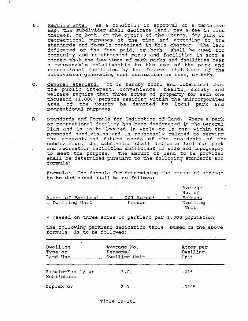
B. Requirements. As a condition of approval of a tentative map, the subdivider shall dedicate land, pay a fee in lieu thereof, or both, at the option of the County, for park or recreationa"l purposes at the time and according to the standards and formula contained in this chapter. The land dedicated or the fees paid, or both, shall be used for community and neighborhood parks and facilities in such a manner that the locations of such parks and facilities bear a reasonable relationship to the use of the park and recreational facilities by the future inhabitants of the subdivision generating such dedication or fees, or both.
C. General Standard. It is hereby found and determined that the publ ic interest I convenience I health I safety and welfare require that three acres of property for each one thousand (1,000) persons residing within the unincorporated area of the County be devoted to local park and recreational purposes.
"D. Standards and Formula "for Dedication of Land. Where a park or recreational facility has been designated in the General Plan and is to be located in whole or in part wi thin the proposed subdivision and is reasonably related to serving the present. and future needs of the" residents of the subdivision, the subdivider shall dedicate land' for park and recreation facilities sufficient in size and topography to meet the purpose. The amount of land to be provided shall be determined pursuant to the fol"lowing standards and formula":
Formula: The formula for determining the amount of acreage to be dedicated shall be as follows:
Acres of Parkland = .003 Acres* .. , Dwelling Unit Person
x
Average No. of Persons Dwelling unit
* (Based on three acres of parkland per 1,00"0 population)
The following parkland dedication table, based on the above formula, is to be followed:
Dwelling Type or Land Use
Single-Family or Mobilehome
Duplex or
Average No. Persons/ Dwelling unit
3.0
2.1
Title 19-101
Acres per Dwelling Unit
.015
.0105
"I'
n [I"" L.
lJ
n n u D n D 0 D 0-
lJ W
rl L~
D j-l l--.J
r-l I I I ' L.-i
II
i l L;
Multifamily
For the purpose of this section, the number of proposed dwelling units shall be determined as follows:' In areas zoned for one dwelling unit per lot or parcel, the number of dwelling units shall equal the n-qmber. of parcels indicated on the tentative map. When all or part of the subdivision is located in _ an area z,oned for mul tiple dwelling units per parcel, the number of dwelling units in the' area so zoned shall e'qual the maximum number of dwelling units allowed under that zone. For residential condominium proj ects, the number of dwelling units shall equal the number of condominium units indicated on the tentative map. For planned development proj ects., the number of dwelling units shall equal the number o! dwelling uni ts indicated on the. approved final development plan. The term "new dwelling unit" does not include dwelling uni ts lawfully in place prior to the date on which the tentative map is approved.
Lands to be dedicated or reserved for park and/or recreational purposes shall be suitable in the opinion of the Director of, Planning and Building Inspection, the Director of Public Works, and the Director of parks::,: and Recreation in 10ci3.tion, topography, environmental
'characteristics and development potential as related to the intended ~se. The primary intent of this section shall be construea to provide the land for' functional recreation uni ts of local or neighborhood service, including put not limited to: tot lots, play lots, playgrounds, neighborhood parks ,playfields, cs>mrnuni ty or district parks, and other specialized recreational facilities that may serve the family group and also senior citizen and child care activities. principal consideration shall be given therefore to lands that offer:
1. A variety of recreational potential for all age
2.
groups;
R~creational opportunit~es within walking distance from residents homes;
3 . Possibility for expansion or connection with school grounds;
4. Integration with hiking, riding and bicycle trails I natural stream reserves and other open space;
5. Coordination with all other park systems; and
6. AccesS to at least one existing or proposed public street.
E. Formula' for Fees in Lieu of Land Dedication.
Title 19-102
1. General Formula. If there is no park or recreational facility designated in the General Plan to be serve the immediate and future needs of the residents of the
_subdivision, the subdivider shall, either dedicate land in the amount provided in section 19.12.010(D) or pay a fee in lieu of dedication equal to the value of the land prescribed for dedication in Section 19.12.010(D) and in an amount determined in accordance with the provisions of Section 19.12.010(G).
2. Fees in Lieu of Land - Fifty (50) Parcels or Less. Except as provided in Section 19.12.010(F), if and has no park or recreational facility, the subdivider shall pay a fee equal to the land value of the portion of the park or recreational facilities required to serve the needs of the residents of the proposed subdivision as prescribed in Section" 19.12.010(D) and in an amount determined in accordance with the" provisions of section 19.12.010(G).
3. Use of Monev. The money collected shall be used, in accordance with the schedule developed pursuant to section 19.12.010 (K), for the purpose of developing new or rehabilitation existing neighborhood or communi ty park or recreational facilities reasonably related to serving the subdivision, including the purchase of necessary land and/or improvement of such land for park or recreational purposes. The money shall be committed within five (5) years after payment" thereof or the issuance of building" permits on" onehalf (1/2) of the lots created by the subdivision, whichever occurs later. If the money is not commi tted, it shall be distributed and paid to the then record owners of the subdivision in the same proportion that the size of their lot bears to the total area of all lots in the subdivision.
F. Gri teria for Requiring Both Dedication and Fee. If the proposed subdivision contains more than fifty (50) parcels, or, in "the case of a condominiym project, stock cooperative or community apartment, if the proposed subdivis ion contains more than fifty (50) dwelling units although the actual number of parcels may be less than fifty (50), the subdivider shall both dedicate land and pay a fee in lieu of dedication in accordance wfth the following:
1. When only a portion of the land to be subdivided is proposed in the General Plan as the site for a local park or recreational facility, such portion shall be dedicated for local park purposes and a fee computed pursuant to the provisions of Section 19.12.010 (G) shall be paid for any additional land that would have been required to be dedicated pursuant to section 19.12.010(G) .
Title 19-103
I ,] i I
I,
n '.-.
[J
o
D D
o 0, o D o IJ lJ
(l l )
G.
H.
2 . When a maj or part of the local park or recreational si te has already been" acquired by the County and only a small portion of land is needed from the. subdivision to complete the site, such portion shall be dedicated, and a' fee, computed according to section 19.12.010(G) shall be paid in an amount equal to the value of the land which would otherwise have been required to be dedicated according to Section 19.12.010(D). The fee shall be used for the improvement of the existing park or . recreational facility or for the improvement of other neighborhood or community parks and recreational facilities reasonably related to serving the subdivision.
Amount of Fee in Lieu of Parkland Dedication. When a fee is required to be paid in lieu of parkland dedication,' the amount of the fee shall be .based upon the estimated fair market value of the land being subdivid~d and· the estimated fair ·market value of the land which would otherwise be required to be dedicated according to Section 19.12.010(D).
The fair market value shall be as determined by the County Assessor at the time of final map or'parcel map approval. I f the subdivider obj ects to the fa ir market value determination, the subdivider may request the Cp.unty to obtain an appraisal of· the property by a qualified real estate appraiser mutually agreed upon by the County and the subdivider, which appraisal will be considered by the County in . det~rmining the fair,,' market value. All costs required to obtain such appraisal shall be borne by the subdivider.
For purposes of determining fair market value pursuant to this subsection, the County Assessor and any appraiser shall consider,a~ong pther things:
1. Conditions of approval of the tentative. mapi
'2 ..
3 •
4 .
The General Plan and zoning requirements for the area;
The location and site cha·racteristics of the property; and Off-site and on-site improvements facilitating use of the property.
Determination of Land or Fee. Whether the County accepts land dedication, or elects to require the payment of a fee in lieu of, or a combination of both, shall be determined by consideration of the following:
1. Policies, standards and principles for park a·nd recreation facilities in the .General Plan;
Title 19-104

2. Topography, geology, access and location of land in the subdivision available for dedication;
3. Size and shape of the subdivision and land available for de9ication;
4. Feasibility of dedication;
5. compatibility of dedication with the General Plan;
6. Availability of previously acquired park property.
The determination by the County as to whether land shall be dedication, or whether a fee shall be charged, or a combination, shall be final and conclusive.
I. Credi t for Improvements and Private Open Space. If the subdivider' provides park and recreational improvements to the dedicated land, the value of the improvements together wi th any equipment 'located thereon shall be a credi t against the payment of fees or dedication of land required by this section.
Planned developments, real estate ,developments, stock cooperatives, and community apartment srojects, as defined in SeC"tions 11003, 10003.1,11'003.4" '--and 11004, respectively, of the Business and Professions Code, and condominiums shall be eligible to, receive a credit, ,as determined by the Board of Supervisors, ~gainst the amount
·of land required to be dedicated, or the amount of the fee imposed, pursuant to this section, for the value of private open space within the development which is usable for active recreational uses.
J. Procedure.
1. At the time of the approval or conditional approval of the tentative map, the Board of Supervisors, shall
'0', determine, after a report and recommendation from the Director of Parks and Recreation, whether land, inlieu fees, or a combination of land and fees, shall be dedication and/or paid bi'the subdivider.
2. The Board of Supervisors, may approve, modify, or disapprove the recommendation of the Director of Parks and Recreation; provided, however, any modification of the proposed recommended condition not previously considered by the Director of Parks and Recreation shall first be referred back to the Parks -and Communi ty Services Director for a report and further recommendation. The Director of Parks and Recreation shall report back to the Board of Supervisors wi thin thirty (30) days. Afte~ the receipt and consideration of the report, gr after thirty (30) days have passed in the event no report is received, the Board of
Title 19-105
'f'
n ~ ..
II
[1
n Il (--1
n [l
0 [j
0 []
0 D 0 f] l_
0 [] i--I
I j
Supervisors may adapt the canditian.
3. The recommendation .of the Directar of Parks and Recreation shall include the fallawing:
a. The amount .of. land required; .or
b. That a fee be charged in lieu .of land; .or
c. That a cambinatian .of land and a fee be required; and
d. The locatian .af the park land and, where appra~riate, the siting and conceptual design Df the park facilities appurtenant thereto, ta be dedicated .or used in lieu .of fees; and
e. The approximate time when the develapment of the park .of recreatian facility shall cammence.
4. At the time .of the rec.ording .of the final map .or parcel map, the subdivider shall dedicate the land and/or pay the fees as determined by the County.
5 . Open space covenants, conditions and' restri·ctions .. far private park .or recreatianal facilities shall be submitted to the Directar .of Parks and Recreatian' prior to appraval of the final map .or parcel map and, if appraved, shall be recorded cancurrently with the final map or parcel map.
K. Schedule of Use .. At the time .of the approval of the final map .or parcel map, the the Director .of Parks and Recreatian shall develap a schedule specifying haw, when, and where it will use the' land .or fees, .or bath, to develop .or rehabilitate park .of recreatianal facilities to serve the residents of the subdivisian.
L. Nat Applicable to Certain Subdivisians.The pravisions .of this Chapter 19.12.010 shall nat apply to the follawing:
1. Subdivisions cantaining four (4) or less parcels and n.at used for residential purpases. However, a candition may be placed an the approval .of such parcel map that if a building permi t is requested far canstructian of a residential structure .or structures an one ·or mare .of the parcels within faur (4) years, the fee pursuant to this secti.on may be required ta be paid by the owner· of such parcel asa canditian to the issuance .of such permit.
2. Commercial or industrial subdivisians.
3. Condaminium proj ects .or stack coaperati ves which consist .of the subdivisian .of airspace in an existing
Title 19-106
.' .
----_._ ..
.,.
apartment building which is more than five (5) years old when no new dwelling units are added.
19.12,.015 SCHOOL FACILITIES/FEES DEDICATION. . ' ,
This section provides for the dedication of land, payment of fees, dedication of facilities, or a combination, for elementary or high school classrooms and related facilities upon the making of certain findings, as a condition of the approval of a residential development.
19.12.020 TITLE.
This section shall be known and may be cited as the "School Facilities/tees Dedication Ordinance".
19.12.025 AUTHORITY.,
This section is adopted pursuant to the provisions of Chapter 4.7, (commencing with section 65970) of Division 1 of Title 7 of
'the Government Code of California.
19.12.030 PURPOSE.
The purpose of this section is to provide a method for financing interim school facilities necessitated by new residential developments causing conditions of overcrowding.
19.12.035 REGULATIONS.
The Board of Supervisors may, from time to time, by Resolution, issue regulations t'o provide for the administration and implementation of this section.
19.12.040 GENERAL PLAN.
The County of Monterey General Plan provides for the location of public schools. Where facilities are to be constructed from fees or land required to be dedicated hereunder, or both, they shall be consistent with the General Plan.
19.12.045 DEFINITIONS.
The following definitions are applicable to this section.
A. CONDITIONS OF OVERCROWDING. "Conditions of overcrowding" means that the total enrollment of an attendance area IS'
school or schools, including enrollment from proposed development, exceeds the capacity of such school or schools within the attendance area, as determined by the governing body of the school district in accordance with standards established in the Education Code.
B. DECISION-MAKING BODY. "Decision-making body" means the Board of Supervisors.
Title 19-107
!\ 
?
2. The conversion of an existing apartment building into a condominium or stock cooperative where no new dwelling units are created.
3. - Any rebuilding of a legally established dwelling unit destroyed or damaged by fire, flood, explosion, act of God or other accident or catastrophe.
4. Any rebuilding of a historical building recognized, acknowledged and designated as such by the County.
5. Any residential complex which, through special use permit, is designated as senior citizens' housing.
6. Any residential unit with one bedroom or less. For the purpo~es of this ~xemption, miscellaneous-use rooms (such as I sewing rooms, solariums, recreation rooms, or a study or a den) and rooms designed for sleeping shall be considered and counted as bedrooms.
19.12.050 OVERCROWDING ATTENDANCE AREA.
The following criteria determine whether there is overcrowding in the school district attendance area:
19.12.055 FINDINGS AND NOTICE OF OVERCROWDING IN ATTENDANCE AREAS.
Pursuant to Government Code section 65970 et:. seq., the governing body of a school district may make a fInding supported by clear and ~onvincinq e~idence that:
A. Conditions of overcrowding exist in one or more attendance areas within the district which will impair the normal functioning of educational programs, including the reasons for such conditions existing;
B. All reasonable methods of mitigating conditions of overc~owding have been evaluated, including district unification, consolidation and reorganization;
C. No feas ible method for reducing such conditions exists. Upon making these findings, the school district must provide the County with written notice of its findings as provided in Section 19.12.55.
19.12.060 FINDINGS - REQUIREMENTS.
Any notice of findings sent by a school district to the County shall specify:
A. The findings listed in Section 19.12.055;
B. A summary of the evidence upon which the findings in Section 19.12.055 were based;
Title 19-109
'" r-] \ .
D'·'
0 0 n lJ 0 n 0 0 0 0 0 ~
0 0 0 0 [1
C. The mitigation measures and methods, including those listed in section 19.12.045 (D), considered by the school district in any de~erminatidn made concerning them by the district;
D.The preci se geographic boundaries of, the overcrowded attendance area or area;
E. Such other information as may be required by a Board regulation.
19.12.065 CONCURRENCE BY COUNTY.
After receipt of any notice offi:t:ldings complying with the requirements of section 19.11.055, the Board, if it concurs with such school 'district findings, shall do so by Resolution.
19.12.070 FINDINGS FOR DEVELOPMENT APPROVAL.
Within an attendance area, where the Board has concurred in a school district's findings that conditions of overcrowding exist, no decision-making body shall approve an application for a residential development with such area, unless such decisionmaking body makes one of the following findings:
A. That pursuant to thi~ section, provision, has been made for payment of fees, dedication of land, or both, or some other provision has· b~en agreed upon by the applicant for a residential development in the school district to mitigate the conditions of overcrowding within that attendance area; or
B. That there ar,e specific, . overriding physical, economic, social or environmental factors, which, in the judgment of the decision-making body, would benefit the County, thereby justifying the approval of ~ residential development otherwise, subj ect to _ the provisions of this Ordinance without
,requiring the payment of fees or the dedication of land or' other alternate provision required by this section; or
C. That agreement has been reach~d between the developer and the school district to alleviate existing conditions of overcrowding.
19.12.075 REQUIREMENTS, STANDARDS AND PROCEDURES.
The following are the requirements, standards and procedures to implement this section:
19.12.080 PAYMENT OF FEES, DEDICATION OF LAND OR DEDICATION OF FACILITIES.
In an attendance area overcrowding exists, the
where the, Board applicant of a
Title 19-:-110
has concurred that proposed residential

T
development, as a condition of approval, or the obtaining of a building permit, shall select among the following forms of contribution:
" . A. Pay fees, make an equivalent arrangement as determined by
the decision-making body in lieu thereof;
B. Dedicate land;
C. Dedicate facilities, or
D. Do a combination thereof, unless excepted as .provided in section 19.12.070, subsection (B)~, as determined by the decision-making body during the hearings and other proceedings on specific residential development applications falling within their respective jurisdictions. Prior to the imposition of the fees, the dedication of land, dedication of facilities, or combination thereof, i"t shall be necessary for the decision-making body acting on the application to make the following determination: "That the facilities to be constructed, purchased, leased, or rented from such fees or the land or facilities to be dedicated, or combination thereof, are consistent with the General Plan. Any facilities to be dedicated shall be consistent with the requirements of the Field Act as specified in the California Education Code.
19.12.085 PAYMENT OF FEES IN SMALL RESIDENTIAL DEVELOPMENTS.
Only the payment of fees may be required i'n subdi:visions containing 50 parcels, or less, or other developments containing 50 units, or less.
19.12.090 STANDARDS FOR FEES OR LAND.
Any requi+,ement imposed pursuant to this section shall bear reasonable relationship and will be limited to the needs of the commupity for interim elementary, or high school facilities, and shall' be reasonably related and limited to the need for the schools caused by the development; provided, the fees shall not exceed the amount necessary to pay five annual lease payments for the interim facilities.
19.12.095 AMOUNT FOR FEES OR LAND.
A. For purposes of computation of fees required by this division, reasonable factors related to the amount necessary to pay five annual lease payments for interim facilities have been determined to be and are hereby adopted as follows:
1. Elementary (K-6) student yield per dwelling unit: .37 students
Title 19-111
"I ~ J
-,
i~J
,I u
0 0 0 0 n LJ
o· 0 0
B.
0 0 0 0 0 0 ~J !]
2. Junior high school (7-8) student yield per dwelling unit: .11 students
3. High school (9-12) student yield per dwell-ing unit: .23 students
4. Number of students per interim classroom: 30 students
5. Amount of five annual leasepayrnents per classroom: $28,800.00
6. Average number of bedrooms per dwelling unit: 2.12 bedrooms
7. Average number of bedrooms in excess of one bedroom per dwelling unit: 1.12 bedrooms
8. Cost of interim classrooms per student ($28,800 - 30): $960.00
9. Average number of. students per bedroom in excess of one bedroom per dwelling unit:
Elementary (.37 - 1.12)= .33 Junior High School (.11 - 1.12)= .10 High School (.23 - 1.12)= . .21
10. Cost per bedroom in excess of one bedroom dwelling unit:
Elementary ($960 x .33)= Junior High School ($960 x .10)= High School ($960 x .21)=
$317.00 96.00
202.00
When fees are required by this division to be paid in lieu of land dedication o~ facilities, ~uch fees shall be, and paid as follows:
•. ,1. Fees per bedroom in excess of one bedroom per· dwelling unit shall be:
$317 for elementary'·school interim facilities $ 96 for junior high school interim facilities $202 for high school interim facilities Any room designed for sleeping and miscellaneoususe rooms (such as sewing rooms, solariums, recreation ·rooms, or a study or a den), is a
. bedroom for the purpose·s· of this section.
2. Fees for each dwelling unit, rented over 60 days, in a mobile horne rental park shall be one-half of the amounts in Section 19. i2. 095 above. It shall be the duty of the park own~r to collect the fee for. the County.
Title 19-112
3. The fees for a mobile horne manufactured housing or site-delivered home on a purchased lot shall be the same as for a site-built home.
4. Provided that if the Board has determined that conditions of overcrowding do not exist with respect to any of the three levels of schools, i. e., elementary I junior high school, high school, then no fee for that level will be assessed.
5. The maximum total fee per bedroom in excess of one bedroom per d~elling unit shall be the sum of the fees for the elementary, junior high school, and high school levels as determined in this section. The maximum total fee per dwelling unit shall be $2,000.
C. For purposes of this section, the annual lease payment per class-room, given in subparagraph (a) above as $28,800, is subject to annual adjustment by the Monterey county Board of Supervisors. When an adjustment of the annual lease payment is made as provided for in this subparagraph, the fees provided for in this section shall be adjusted proportionately.
D. The total' land area required by this section to be dedicated shall be at least equal in monetary value as to the fees which would be otherwise required by section 19.12.095 (B). The Assessor shall determine and establish the monetary value of' land area for the. purposes or this Division.
19.12.100 FEE REQUIRED.
If the payment of a fee is required, such payment shall be made at the time the building permit for a residence is approved and issued or, in the case of a mobile home, at the time the lot or space is first occupied. Fees shall be held in trust by the County until transferred to the affected school district or districts.
19.12.105 LAND DEDICATION.
When land is to be dedicated, it shall be offered for dedication in substantially the same manner as prescribed in the County Subdivision Ordinance. Land shall be deeded directly to the school district or districts under procedures adopted by the County.
19.12.110 REFUNDS.
A. If a final subdivision map, a parcel map, or conditional use permit is vacated or' voided, and the County still retains the land, and if the applicant so requests, the Board shall order such land returned.
Title 19-113
il L ..... J
II
U
n LJ
·n I I L-,
[J
'0
r~
I I I I L~
B. If a residential development approval is vacated or voided, and if the County still retains the fees collected therefor,. and if the applicant so requests, the Board shall order the fees returned to the applicant.
19.12.115 SCHOOL DISTRICT SCHEDULE.
Following concurrence by the Board pursuant to Section 19.12.070, the Director of Planning and Building Inspection shall notify each school district affected thereby. The governing body of the school district shall then submit a schedule specifying how it will use the fees, land, or facilities to solve the conditions of overcrowdl.ng. The schedule shall include the school sites ,to be used., the classroom facilities to be, made available, and the time when such facilities will be available.' In the event the governing body of the school district ~annotmeet the schedule, it shall submit modifications· to the Board of Supervisors and the reasons for the modifications.
19.12.120 PROHIBITIONS.
The following are prohibitions on levy of fee or dedicati:on of land after receipt ot apportionment and uses and limitations 'of uses of lands and fees:
19.12.125 PROHIBITION ON LEVY OF FEE OR DEDICATION OF. LAND AFTER RECEIPT OF APPORTIONMENT.
After facilities have been completed with funds received pursuant to. the Leroy F. Green State School Building Lease-Purchase Law of 1976 (Chapter 22 (commencing with-Section 17700) of .Part 10 of the Education Code), the City or County shall not be permitted thereafter, pursuant to this chapter or· pursuant to any other school facilities financing arrangement such district may have with builders of residential devel'opments, to levy any fee o~ to require the dedication 6f land within the attendance area of the district.
After facilities have been complet'ed and occupied with funds received pur~;uant to the Leroy' F •. Green State School Building Lease-Purchase Law of 1976 (Chapter 22 (commencing with Section 17700) . of Part 10 of the Education Code), the County shall refund to the developer of the residential development who has made a contribution under this ordinance, the amount of any fee paid which is in excess of the amount necessary to meet the needs of the school district for interim, elementary, or high school facilities.
Al though the school may have received Green Act money, it. may still have a need for interim facilities created by local development.
Ti"':.le 19-114
19.12.130 CONDITIONS OF SUBSEQUENT OVERCROWDING.
Nothing in this agreement is intended to prohibit the district from subsequently filing another resolution of overcrowded conditions pursuant to this Ordinance as specified in this section. - .
19.12.135 USE OF FEES, LAND, AND FACILITIES.
All fees, land, and facilities, collected pursuant to this Ordinance and transferred to a school district, shall be used by the district only for the purpose of providing interim elementary or high school classroom and related facilities.
19.12.140 AGREEMENT FOR FEE DISTRIBUTION.
If two separate school districts operate schools in an attendance area where the Board concurs that overcrowding conditions exist f6r both school districts, the Board will enter into an agreement with the governing bodies of both school districts for the 'purpose of determining the division of revenues from the fees levied pursuant to this section.
19.12.145 ACCOUNT.
Arty school district receiving funds, land facilities pursuant to this Ordinance shall maintain a separate account for any fees paid and disposition of land received, and shall file a report wi th the Board on the balance and account at the end 'of the previous fiscal year and the facilities leased, purchased, or constructed during the previous fiscal year. In addition, the report shall specify which attendance areas will continue to be overcrowded when the fall term begins and where conditions of overcrowding will no longer exist. such report shall be filed by August 1 of each year, and shall be filed more frequently at the request of the Board.
19.12.150 TERMINATION OF DEDICATION OR FEE REQUIREMENTS.
When ~"i t is determined by the Board 0 f Supervisors that conditions of overcrowding no longer exist in attendance area, the decision-making body shall ceaSe imposition of any requirements under this section.
19.12.155 BRIDGE AND MAJOR THOROUGHFARE CONSTRUCTION FEES.
The purpose of this section is to make provision pursuant to Government Code section 66484, for the assessment and collection of bridge facility and major thoroughfare construction fees as a condition for the approval of a final map or parcel map when the fees are necessary to defray the actual or estimated costs 'of constructing such bridge facilities or major thoroughfares.
Title 19-1i5
:]
IJ n Ii
lJ
fJ
n n o o u o o
[,
U
19.12.160 DEFINITIONS.
Whenever the following terms are' used in this section they shall have the meanings ascribed to them in this section:
A. "Areas of benefit" means those areas which are established by the County Board of Superv isors pursuant to the provisions of section 19.12.175 for the purpose of assessing and collecting fees for the construction of bridge facilities and major thoroughfares.
B.
C.
D.
E.
"Construction" includes way, administration of construction.
design, acquisition of right-ofconstruction contracts and actual
"County" means the County of Monterey.
"Major thoroughfare" means anyco.unty or state maintained road, whether existing or proposed which is shown on the circulation element of the county's General Plan.
"Subdivider" means a person, firm, corporation, partnership or association who proposes to divide, divides, or~auses to be divided, real property intq a subdivision for himself or for others except that employees and consultants of .such persons or entities, acting in. such capa~ity, ar~ not subdividers.
F. "Subdivision" means the division, by any subdivider, or any unit or units of improved or unimproved land, or any portion thereof, shown on the latest equalized county assessment roll as a unit or as contiguous units, for the purpose of sale, lease or financing, whether immediate or future ,except for le~ses of agricultural land for agricul tural purposes. Property shall' be considered as contiguous units even if i t its separa ted by roads, streets , utility easements or railroad rights-of-way. "Subdivision'" includes a condominium project, a community apartment project, and the conversion of five or more ~xisting dwelling units to a stock cooperative, as defined in section 66424 of the Government Code.
19.12.165 FEES .
. In order to defray the costs of construction of needed· bridge facilities and major thoroughfares, fees shall be imposed as a condition for the approval of final maps and parcel maps as follows:
A. As a condition for approving a final map or parcel m~p (pursuant to the provisions of the Subdivision· Map Act, Government C.ode Section 66410 et seq. and related county ordinances) when any portion thereof includes property which is located within an a'rea of benefit, the subdivider shall pay the fee' apportioned to the property as
Title 19-116
...
established by the Board of supervisors for that area of benef i t pursuant to the procedures set forth in Section 19.12.175
B. In the case of maj or thoroughfares, the payment of fees shail not be required unless the thoroughfares are in addition to or a reconstruction of any existing major thoroughfare serving the area at the time of the adoption of the boundaries of the area of benefit.
C. In rE~gards to planned bridg'e facilities, the payment of fees shall not be required unless the facil i ty is an original bridge serving the area or an addition to any existing such facility serving the area at the time of the adoption of the boundaries of the area of benefit.
D. Fees required to be paid pursuant to subsection A of this section shall be paid prior to the approyal of a final map or parcel map.
19.12.170 PAYMENT METHODS.
A. Consideration in lieu of fees required by Section 19.12.065 may be accepted.
B. 'When fees are required by Section 19.12.065 su~h fees shall be deposited in a planned bridge facility and/or, maj or thoroughfare fund. A separate fund shall be establfshed for each area of benefit. Moneys in the fund shall be expended solely for the construction or reimbursement for construction of the bridge facilities and/or major thoroughfares serving the area to be benefited and from which the fees - comprising the fund were collected or to reimburse the county for the costs of constructing the
,bridge facility or major thoroughfare.
C. The County may advance money from its general fund or road fund to pay the cost of constructing the bridge facilities ~nd/or major thoroughfares and may reimburse the general f'und or road fund for the advances from planned' bridge facility and/or major thoroughfare funds established to finance the construction of the bridge facilities and/or major thoroughfares.
D. The County may require or accept the dedication and/or improvements along a major thoroughfare and may reduce the fees assessed against that property by an amount equal to the cost of the improvements as determined by the Director of Public Works, if the value of improvements were included in the calculation of the fee.
E. Funds shall be disbursed upon wri tten authority of the Director of Public Works.
Title 19-117
.,.
n ~I"
., I L __ ,
n D O·
0 0 fJ [l
0 0 0 0 Q
0 []
0 1] (I
Li.
F. Notwithstanding any other provision of the ordinance codified in this chapter, . the fees collected herein as a resul t of a development proj ect may be allocated between different areas of benefit, provided, that:
1. The pioject ia in one designated area of benefit and contiguous to another such area of benefit; or is in two different areas of benefit as a result of an area of benef.it boundary bisecting the project; and
2. It is demonstrated to the satisfaction of the Director of Public Works that each affected area of benefit will be significantly ,impacted by the proj ect. A traffic study or supplemental traffic study shall be conducted at the expense of the party requesting allocation of funds and approved by the Director of Public Works documenting the impacts to each area of 'benefit; and
3. The project consists of more than fifty (50) lots in' the case of a subdivision.
G. ,The amount to be paid or percentage of allocation to each impacted area of benefit shall be determined by the Board of supervisors.
19.12.175 AREAS OF BENEFIT.
Puriuant to the procedures set forth in this chapter, the Board of Supervisors may establish areas of benefit and impose reasonable fees on final maps and parcel maps. which affect properties within such areas which are benefited by the construction of bridge facilities or major thoroughfares.
, .'
19.12.180 HEARING.
A. Areas of benefit may be established by the Board of supervisors following .a public. hearing thereon. At the Fearing the boundaries of the area of benefit, the costs;' whether actual or estimated, and a fair. method of allocation of costs to the area of benefit and fee apportionment shall .be established.
B. A description of the boundaries of the area of benefit, the costs, whether actual or estimated, and the method of fee apportionment established at the hearing shall be incorpora ted in a Board of Supervisors resol ution, a certified copy of which shall be recorded with the County Recorder.
C. In the case of major thoroughfares, the method of fee apportionment established by 'the Board of Supervisors shall not provide for higher fees on land abutting the proposed improvement, except where the abutting property is provided' direct usable access to the major thoroughfare.
Title 19-118
,.
19.12.185 OBJECTION HEARING.
A. At any time not later than the hour set for hearing, pursuant to section 19.12.180, any owner of property located within an area of benefit may make protest against the proposed bridge facility and/or maj or thoroughfare or against the extent of' the area to be assessed or against both of them. The protests must be in writing and must contain a description of the property in which each signer
. of the protest is interested, sufficient to identify the same, and if the signers are not shown on the last equalized assessment roll as the owners of the property, mus~ contain or be accompanied by written evidence that the signers are the owners of the property. All such protests shall be delivered to the Clerk of the .Board of Supervisors and no other protests or objections shall be considered. Any protests may be withdrawn by the owners making them, in writing, at any time prior to the conclusion of a public hearing.
B. If there is a written protest filed with the Clerk of the Board of Supervisors by the owners of more than one-half of the area of the property to be benefited by ~he improvement, and sufficient protests are not withdrawn so as to reduce the area represented to less than one-half of that to be benefited, then the proposed proceedings shall be abandoned, and the Board of supervisors shall not, for one year from the filing of the written protests, commence. 'or carryon any proceedings for the same improvement under the provisions of this chapter.
C. If any majority protest is directed against only a portion of the improvement, then all further proceedings under the provisions of this chapter to construct that portion of the improvement so protested against shall be barred for a period of one year, but the Board of Supervisors, wi thin the one-year period, from commencing and carrying on new proceedings for the construction of a portion of the improvement so protested against if it finds by the affirmative vote of four-fifths of its members that the owners of a maj ori ty of the property wi thin the area of benefit are in favor of going forward with the portion of the improvement or acquisition.
19.12.190 HEARING NOTICE.
Notice of any hearing held pursuant to this chapter shall be given in accordance with Section 65091 of the Government Code. In addition to the requirements of Section 65091 of the Government Code, the notice shall contain preliminary information related to the boundaries of the areas of benefit, estimated cost and method of fee apportionment. The area of benefit may include land or improvements in addition to the land or improvements which are the subj ect of any map or building
Title 19-119
'I :~ j
l' 1..J
n [,-1
U
LJ
rl L~
n [1
0 0 n LJ
0 ,'\ u 0 0 0 0 [j (1 l !
...
permit application to be considered at the proceedings for which notice of the hearing was given~
19.12.195 CONSTRUCTION CONTRACTS.
Whenever-, pursuant to this chapter, a subdivider or land developer is required to pay a fee for the, construction of a bridge facility and/or maj or thoroughfare as a condition precedent to the approval o~ a final map or parcel map and the bridge facility and/or major thoroughfare is dedicated to the publ ic, the Board of Supervisors inay contract wi th the subdivider or land developer for the construction of the bridge facility and/or major thoroughfare, .and reimburse the subdivider or land developer for the cost of constructing the bridge facility and/or major thoroughfare~
19.12.200 GENERAL P~ CONFORMANCE.
The bridge and major thoroughfares for which payment of a fee is required shall conform to the circulation element of the General Plan and the transportation or flood control provi~ions therein.
19.12.205 REGULATIONS ISSUANCE.
The Board of Supervisors may" by resolution, issue regulations to establish administration procedures, interpretatio;ns: and policy direction under this section.
19.12.210 PROVISIONS ADDITIONAL.
The provisions of this section are intended to be an addition to and not a sUbstitute for other requirements of this code and the Subdivision Map, Act including those provisions concerning the dedication' of lands for public roads and the improvement of public roads as a condition of approval of a final map or parcel map.
Title 19-120
l'
\J ~I' I , \ __ J
:l t __ ,
:J '-
i] L_
r-' U
n l_~
0 n i I "--'
o
'I I ' I I l---.J
LJ f""""l
" I I
U
u o
Chapter XIII. IMPROVEMENT AGREEMENTS
19.13.005 IMPROVEMENT AGREEMENTS.
A. If the improvement works required pursuant to Chapter 10 of this title are not satisfactorily completed before the filing of either the final map or the parcel map for which the required finding has been made pursuant to hereof, the owner(s) of the subdivision shall, prior to or concurrently with the approval of such' map, enter into an agreement with County, agreeing to have the work completed within the time required, and specifying that should such work not be satisfactorily completed within the time limit, the County may complete all specified improvements 'and be completely reimbursed for such improvements by the owner of the subdiv is ion. Any such impr.ovement agreement shall be approved as· to form by County Counsel and shall at a minimum provide:
E.
1. Construction of all improvements per the approved plans.
2.
3 •
4.
5.
6. ....
7.
8 .
Completion of improvements within .approval of the final or parcel map. date may be extended by the decision provided in this Chapter. -'
one year from This .comp:letion making body as
Evidence of Insurance to protect owners of adjacent properties from adverse affects of construction of the improvements.
Payment of inspection fees in accordance with the County's' established fees and charges.
Improvement security.
Maintenance and repair of any defects of the construction or failures and causes thereof .
Release of the County from all liability incurred by the development and payment of all reasonable attorney's fees that the County may incur because of any legal action arisin~from the development. .
Registered Civil Engineer's statement of approved" construction.
Any such agreement may recognize and allow for the subdivider to seek to initiate and consummate" proceedings under an appropriate assessment act for the financing and completion of the improvements so long as the subdivider remains responsible to construct the - improvements at the subdi v ider I s expense. Any agreement to construct or
Title 19-121

install off-site improvements on land in which the County does not have sufficient title or interest, shall be condi tioned to. require action at such time as the County obtains an interest in the land which will permit the improvements to be made.
19.13.01a EXTENSION OF IMPROVEMENTS AGREEMENTS.
A. The completion date for any improvements to be constructed under an improvement agreement may be extended by the County upon written request by the subdivider and th~ submittal of evidence to justify such extension. The request shall be· made not less than thirty (30) days prior to the expiration of the improvement agreement. In consideration of the extension, the following will be required:
1. Revision of the improvement plan to provide the current design and construction standards required by the responsible department;
2. revised improvement construction ·estimate to reflect current improvement costs as approved by the responsible department;
3. increase of improvement securities in accordance with revised construction estimates;
4. increase in any inspection fees to reflect current fees.
19.13.015 IMPROVEMENT SECURITY REQUIRED.
A. The furnishing of security shall be required in connection. with any security agreement. No final or parcel map may be approved until all required security has been received and approved. Unless a different form of security allowed in Government Code section 66499 is specifically authorized by the Board of Supervisors, the se~urity to ensure performance I payment of labor and materials I maintenance and warranty, the form of security shall be one or a co~ination of the followi~g:
'l:. A bond or bonds by one or more duly authori zed corporate sureties in the form set forth in Government. Code sections 66499.1 and· 66499.2.
2. A deposit, either with the County or a responsible escrow agent or trust company of money or negotiable bonds of kind approved for securing deposits of public monies.
3. An instrument of credit or a set aside letter from one or more financial institutions subj ect to regulation by the state or federal government and pledging that the funds necessary to carry out the act or agreement are on deposit and guaranteed for payment.
Title 19-122
n
il n
II
(l
i I L.
('1
li
",
a.
b.
PERFORMANCE SECURITY A performance bond or . securi ty in the. amount of one hundred percent (100%) of the estimated construction cost to guarantee the construction or installation of all improvements shall be' requ ired 0 fall subdivisions. An addi tional amount of fifty pe~cent (50%) of the estimated construction cost shall be required to guarantee the payment to the subdivider's contractor, subcontractors, and to persons furnishing labor, materials or equipment for the construction or installation of improvements. MATERIAL AND LABOR SECURITY The estimate of construction or installation costs shall be as approved by the County and shall provide for:
1.
2.
Not less than five percent (5%) nor more than ten pe·rcent (10%) 'of the total construction cost for contingencies.
Increase foi .projected inflation computed to the estimated midpoint of construction.
c. The estimat.e of maintenance costs for private landscaping and' irrigation shall be included. for the estimated maintena~ce for up to two years .
. l
d.. WARRANTY SECURITY Upon acceptance of dedicated subdivision improvements by the County, the subdivider shall provide security in the ~mount as required by the County· to guarantee. the improvements throughout the warranty period. The amount of the warranty security shall be not less than twenty (20%) of the cost of the construction. The security shall be retained for the one year warranty period.
e. MONUMENT SECURITY To the extent permitted by Chapter 9 'of the Subdivision Map Act and .this chapter, monuments may be set after the recording
. of the final map if the subdivider's engineer or surveyor certifies On the map that the monuments will be seton or before a specified later date, and prov ided that the sUbd.:LV ider furnishes security pursuant to an agreement with the County guaranteeing the payment of the cost of setting the monuments.
19.13.020 RELEASE OF IMPROVEMENT SECURITIES.
A. PERFORMANCE SECURITY The performance security for dedicated improvements shall be released only upon acceptance of the improvements by the County and when the approved warranty security has been filed with the County. The performance security for other· improvements shall be
Title 19-123
. .
. __ ._-- ---- ----~
released only upon satisfactory passage of final inspection and/or receipt of the engineer's certification of satisfactory completion as required for the improvement and when any required maintenance and/or warranty agreements and secu~ity haye been delivered to the County.
B. MATERIAL AND LABOR SECURITY Security given to secure payment to the contractor, subcontractors, and to persons passage of the time within which claims of lien are required to be recorded pursuant to civil Code - 3114 et. seq. and after acceptance of the work, be reduced to an amount equal to the amount of all claims therefor filed and of which notice has been given to the County. The balance of the security shall be released upon the settlement of all,such claims and obligations for which the security was given.
C. WARRANTY SECURITY The warranty security shall be released upon satisfactory completion of the warranty period provided:
1. All deficiencies appearing on the warranty deficiency list for the subdivision have been corrected.
2. Not less than twelve (12) months have elapsed since the acceptance of the improvements by the county or the filing of the notice of completion by the subdivider, whichever is later.
D. MONUMENT SECURITY The monument security shall be releas.ed upon sa'tisfactory completion of the monumenting work and that the Engineer or Surveyor doing such work has received payment for such work.
"',
Title 19-124
I. :J
"
lj
i'J ' I L
IJ o
[J
Chapter XIV. ENFORCEMENT AND PENALTY
19.14.005 NO CONSTRUCTION OR USE IN VIOLATION.
A.
B.
C.
No person shall sell, lease, or finance any parcel or parcels of real property or commence construction of, any building for sale, lease or financing thereon, except for model homes, or allow occupancy 'thereof, for which a final map or parcel map is required by this ordinance until sucr\ map thereof is in full compliance with the provisions of this ordinance and has been filed for record by the County, Recorder.
Nothing contained in this ordinance shall be deemed to prohibit an offer or contract to sell, lease, or finance real property or to construct improvements thereon where such sale, lease, or financing, or the commencement of such construction,' is expressly conditioned· upon the approval and filing of a final subdivision map or parcel map, as required under this subdivision.
Nothing in this section shall in any way modify or affect the provisions of section 11018.2 of the Busines~ and Professions Code.
D.' ~ No grading or clearing of trees, brush or vegetation exceeding shall be allowed that which is, necessary ,for surveying or on-going land'and vegetation maintenance purposes as evidenced by a field inspection of the property to be s'ubdivided prior to the approval of a tentative map or tentative parcel map shall be cause for disapproval or the tentative map.or tentative parcel map. No application for a tentative map or tentative parcel map may be accepted for processing of a subdivision for a term determined by the Board of Supervisors to allow for proper compaction and re-establishment of disturbed soil covered by appropriate vegetation.
E. '''\
No grading or clearing of trees, brush or vegetation shall be allowed exceeding that which is necessary for surveying or on-going land and vegetation, maintenance purposes as evidenced by a field inspection of the property to be subdivided prior to the approval of the improvement plans by the Board of Supervisors. Any such grading and clearing of trees, brush or vegetation may be cause for disapproval of the final' or parcel map by the Board of Supervisors. No final or parcel map may be processed for a term determined by the Board of Supervisors to allow for proper compaction and re-establishment of disturbed soil covered by appropriate vegetation.
Title 19-125
19.14.010 ALL COUNTY OFFICIALS SHALL ENFORCE.
All departments, officials, and public employees of the County of Monterey which are vested with the duty of authority to issue permi ts Gr licenses, shall conform to the provisi.ons of this ti tle, and shall issue no such permits or licenses for uses, buildings, or purposes where the same would be in conflict with the provisions of this title, and any such permits or licenses, if issued in conflict with the provisions of this title, shall be null and void.
19.14.015 CIVIL ENFORCEMENT AGAINST NUISANCE.
A. Any building 'or structure set up, erected, constructed, altered, enlarged, converted~ moved, or maintained, contrary to the provisions of this title, and/or any use of any land, building, or premises, establ ished, conducted, operated, or maintained contrary to the provisions of this title, shall be, and the same is hereby declared to be a violation of this title, and a public nuisance.
B. The County may summarily abate the public nuisance and the county Counselor the District Attorney upon order of the Board of Supervisors may bring civil suit, or other action, to enjoin or 'abate the nuisance.
19.14.020 EACH DAY IS A VIOLATION.
Each day any violation of this title continues shall be regarded as a new ano. separate offense. The remedies provided in this chapter shall be cumulative and not exclusive.
19.14.025 CIVIL ENFORCEMENT.
Any person, firm or corporation who creates or maintains a public nuisance in violation of this title shall be liable for the costs of abatement which shall include, but not be limited to:
A. Costs of' investigation; B. Court costs; C. Attorney's fees; D. Costs of monitoring compliance.
Upon a continuation of the public nuisance after notice from the County to cease the nuisance, any person, firm or corporation shall be liable for the costs of abatement set forth above plus a civil penalty of fifty percent (50%) of those costs payable to the County in addition to any other costs of enforcement imposed by the Court.
19.14.030 PENALTY DESIGNATED.
A. Any offer to sell, contract to sell, or sale made contrary to the provisions of this title shall be a misdemeanor, and
Title 19-126
\~I
l '- j
J ,I
: . .-1
o
D o " I I LJ
, .. , I I I :
I I·
I ~ • __ .:.
II
any person, firm, corporation or partnership, upon conviction thereof, shall be punishable by a fine of not more than five hundred dollars or by imprisonment in the County Jail for a period of not more than six months, or by both such fine a~d imprisonment.
B. Nothing contained herein shall be deemed to bar any legal, equi tabl e, or summary remedy to which the County 0 f Monterey or other political subdivision or person, firm,
. corporation, partnership or co-partnership may otherwise be entitled, and the County of Monterey or any other political subdivision, person, firm, corporation, or partnership may bring an action in any court possessing jurisdiction or restrain or enjoin any attempted or proposed subdivision or sale in violation of this title.
19.14 .. 035 TRANSFERS OR CONVEYANCES IN VIOLATION.
Any transfer or conveyance,or purported transfer or conveyance, or agreement to transf~r br convey any parciel of land withou~ compliance with the terms of this title shall be voidable at the option of the grantree in accordance with the provisions of Sections 66499.32 and 66499.33 of the Government Code of the State of Calif6rnia, as the same may be amended from time to t~me.
19~14.040 REAPPLItATION.
When an application for a Standara.· or Minor Subdivision is . denied by, the appropriate authority, no ne~' appli!=ation for a Standard or: Minor Subdi vis-ion which is substantially the same design as the one denied shall be considered for a period of one year following such denial.
19.14.041 PARCEL LEGALITY STATUS DETERMINATION.
A. A particular parcel Which has the status of being a legal parcel shall be determined by consideration of whether the parcel is:
B.
1.
2 .
Enti tIed to a certificate of Compliance pursuant to Chapter. In violation of the Subdivision Map Act or the Mont~rej County Subdivision Ordinance.
An interested 'person may apply for a Parcel Legality status Determination by application pursuant to the procedures set forth in this Chapter. If the county determines that the parcel in question is shown ·on a duly filed and recorded Final Map, Parcel Map, or Official Map (as defined at Government' Code section 66410 et seq.) or entitled t.o an Unconditional Certificate of Compliance, or has satisfied all conditions of a conditional Certificate of Compliance,
Title 19-127
.'
such parcel shall be determined to be a legal parcel so long as it is not combined or merged with another parcel or in violation of the Subdivision Map Act or the Monterey county Subdivision Ordinance. Determination that a parcel is a· legal 'parcel does not entitle the parcel owner to issuance of a building permit or other development permit or approval absent application for and compliance with the requirements for a building penni t or other development permit or approval.
1. The application shall consist of a letter of request for a Farcel Legality Status Determination with the following information:
a. The names(s) of the current owner of record; b. The assessor's parcel numbers(s) ; c. The assessor's parcel map(s) with boundary
lighted of the par~el in question; d. evidence which indicates legality of the parcel
of the time of its creation.
2. Evidence of parcel legality shall consi:::;t of the requirements as indicated in section 19.14.045.
3. If a parcel (s) is deemed legal, the County shall record an Unconditional certificate of compliance describing said real property. '
4. If the County determines that the pa'rcel in question does not meet the requirements, the County shall issue a Ccndi tional Certificate of Compliance pursuant .... to section 19.14.050:
19.14.045 UNCONDITIONAL CERTIFICATES OF COMPLIANCE.
A. Any person who owns real property, or is buying such land under a contract of sale may request the County to determine by application for Parcel Legality status Determination whether the real property in question complies with the provisions of the Subdivision Map Act and. t:dunty Ordinances enaC'~ed pursuant thereto.
1. A parcel qualifies for an ,Unconditional certificate of Compliance if the real property in question complies with the provisions of the Subdivision Map Act and County Ordinances enacted pursuant thereto as follows:
a. The subject property is 2.5 acres or greater and was conveyed by a separate document as a separate parcel on or before March 7, 1972. written ev idence shall be required to support this finding.' Evidence may' be in the form of a contract of sale, grant deed, or deed of trust which was recorded on or before March 7, 1972, or other evidence such as copies of receipts for installment payments, etc., or similar written documentation which establishes a bonafide
Title 19-128
i ! I ''-. .J
i ( I I
I ' ! ( LJ
! \
( ! I
; "
'--'
I \ , I
'---<
\
1 " I, I
i t , i
2.
3 • .........
b.
c.
d.
e.
conveyance on or before March 7, 1972; The subject proper.ty is less than 2.5 acres and was conveyed by a separate document as a separate parcel on or before March J, 1964. Evidence may ,be in the form of a contract of sale, grant deed, or'deed of trust which was recorded on or before March 3, 1964 or other evidence ~uch as copies of receipt~ for installme'nt payments, etc., or similar written documentation which establishes a bonaf ide conveyance on or before March 3, 1964; 'and The parcel in question complies with the provisions of the Subdivision Map Act at the time of its creation; and ' At the time the contract, deed, or other document creating the sUbject parcel was signed, the subject parcel, complied with the applicable county ordinances then in effect, including the parcel size required by the then applicable zone district; and The parcel in question has not been ccmbined by the owner, and is not subject to merger; or
The parcel development" 66499.34:
in question pursuant to
has been "approved for Government Code section
a.
b.
c.
.,'
By issuance of a permit or.g~ant of. approval fo!;". development of the parcel in ques.ti6h i or By improvements that have been completed prior to
'the time' a permi t or 'grant of approval for development was required by the County Ordinance.s in effect at the time of the improvement; or By improvements that have been completed in reliance upon a permit or grant of approval for development; or
The parcel in question is conclusively presumed to be lawfully created,' pursuant to Government Code section, 66412.6, under the following circumstances:
a.
b.
A parcel created by a minor land division shall be conclusively presumed to be, lawfully created if: Fewer than five parcels were created at the time of creation of the parcel in question; and the parcel was created on or before March 7, 1972.
A parcel owned by a subsequent bona fide purchaser shall be conclusively presumed to be lawfully created if the parcel was created on or before March 7, 1972; and the parcel was acquired by a subsequent, purchaser for val uabl e consideration and without actual or constructive knowledge of a violation of the Subdivision Map
Title 19-1-29
,.
Act or county Ordinance enacted pursuant thereto; and
c. At,the time of its creation, the parcel complied with the Subdivision Map Act and County Ordinances enacted pursuant thereto. If the parcel owned by the subsequent bona fide purchaser did not comply with the subdivision Map Act and County' Ordinances enacted pursuant thereto at the time of its creation, then a Conditional (rather than an Unconditional) certificate of Compliance shall be issued pursua~t to 19.14.050.
4. For purposes of Subsection 19.14.045(A.l.b), a parcel shall be deemed created on or before March 7, 1972, if prior thereto the parcel was conveyed by a deed, deed of trust, or bona fide contract of sale (and in the case of a division creating five or more parcels was. in compliance with County Ordinances in effect at the time, including minimum parcel size). A parcel shall riot be deemed created if it was:
a.
b.
c.
d.
e.
Solely the result of a right-of~way dividing parc.els; or Shown solely on an unrecorded subdivision map or an unrecorded parcel map; or As to divisions creating five .or more pa,rcels, the parcel did not meett~ . .;: min.imum parcel size. of the zoning applicable to the property., at the time such parcels were originally created; or The parcel was described as a lIparcel" on one deed and the owner is unable to present documentation showing that the parcel was previously separately conveyed by a separate recorded deed on or before March" 7, 1972; or The parcel was created under circumstances which demonstrate an intent to circumvent th~ Subdivision Map Act or County Ordinances adopted pursuant thereto.
19.14.050 CONDITIONAL CERTIFICATES OF COMPLIANCE.
A. If the County determines that the parcel in question does not comply with the provisions of the Subdivision Map Act or County Ordinances enacted pursuant thereto, and does not otherwise qualify for an Unconditional Certificate of Compliance, it shall issue a Conditional Certificate of Compliance, as follows:
1. If applicant is the current owner of record and was the owner of record a't the time of the initial violation, the County shall issue and record a Conditional Certificate of Compliance imposing such
Title 19-140
B.
IJ
{' \
Ll
C.
, ,
2.
conditions as would be applicable to a current division of the property. If applicant was not the owner at the time of the initial violation, the County shall issue and record a Conditional certificate of Compliance imposing such conditions as would have been appl icable to, the division of the property at the time applicant acquired his or her interest,therein.
The effect of the certificate of Compliance is as follows:
1.
2.
An Unconditiona~ certificate of Compliance operates as a final determination that the parcel in question is a legal parcel for the purpose of sale, .lease or financing. such certificates does not entitle the parcel owner to a building permi t 'or grant of development approval absent compliance with other requirements for such building permit or development approval.
A Conditional. Certificate Of Compliance serves as notice to the applicant or subsequent grantee,' transferee I or assignee tha tf,ul f illment and implementation of the conditions given shall be required 'prior to the parcel in question being deemed a legal parcel for the purpose' of sale l lease, or financing. For that reason, conditions relating to violation, 'combination or merger shall' be included. Compl iance ,with such conditions does not e:t;lti tIe, the parcel owner to a building permit or grant' of dev~lopment approval absent compliance wit~:othe~~ requirements for such building permit or deve~opment approval. .
The County may, as a condition to granfing a Certificate of Compl iance, (impose such conditions as wo·uld have been applicable to the division of the property at the time the ~pplicant acquired his or her interest therein, and which. had been established at such time by this title enacted pursuant thereto, except that where the applicant was the owner of record at the ·time of the initial violation of the provisions of this title enacted pursuant. tbereto who by a grant of the real property creat~d a parcel or parcel in violation of title enacted pursuant thereto, and such person is the current owner of record of one or more of the parcels which were created as a result of the grant in violation of'this title ~nacted pursuant thereto, then the County may i~pose such conditions as would be applicable to a current division of the property. Upon making such a determinat,ion and establ,ishing such conditions I the County shall record a Conditional Certificate of Compliance to be filed for record with the County Recorder. The certificate shall serve as notice to the' property owner or vendee who has applied for the certificate pursuant to this title, a
Title 19-131
-----~ -------~------------- ------------------,
grantee of the property owner, or any subsequent transferee or ass ignee of the property that the fulfillment and implementation of such conditions shall be required prior to subsequent issuance of a permi t or other grant of approyal for.development of the property.
D. Whenever the County has knowledge that real property has been divided in violation of the provisions of this title enacted pursuant to state Law, it shall cause to be mailed by certified mail to the then current owner of record of the property a notice of intention to record a notice of violation, describing the real property in detail, naming the owners tpereof, and stating that an opportunity will be given to the owner to present evidence. The notice shall specify a time, date, and place for a meeting at which the owner may present evidence to the appropriate decision making body why the notice should riot be recorded. The notice shall also contain a d~scription o~ the violations and an explanation as to why the subj ect parcel is not lawful.
E.' The meeting shall take place no sooner than 30 days and no later than 60 days from date of mailing. If, wi thin 15 days of receipt of. the notice, the owner of the real property fails to inform the County of his or her objection to recording the notice of violation, the appropriate decision· making body shall direct the' recording of the notice of violation with the County Recorder. If, after the owner has presented evidence, the appropriate/decision making body determines that the property has in fact been illegally". dividE;Q., .the County shall reco:r:d i;:ne notice of' violation with the county recorder. The notice of violation, when recorded, shall be deemed' to be constructive notice of the violation to all successors in interest in such property. The County Recorder shall index the names of the fee owners in the general index .
...... ..... ,
Title 19-132

'l I I
~\ U
I' , I . l~~
n tJ
19.14.055 FINAL MAPS AND PARCEL MAPS CONSTITUTE A CERTIFICATE OF COMPLIANCE
A recorded final map or parcel map, shall constitute a certificate of Compliance with respect to the parcels of real property ?escrib~d therein.
19.14.060 SEVERABILITY
If any section, subsection, sentence, clause or phrase of this Title is for any reason held to be invalid, such decision shall not affect the validity of the remaining portions of this Title. 'I'he Board of Supervisors hereby declare that it would have passed this Title and each section, subsection, sentence, clause and phrase thereof, irrespective of the fact that anyone or more sections, subsection, sentences, ,clause, or phrases be declared invalid.
PASSED AND ADOPTED this 31st day 'of Nay ----~-----------------1988, by the following vote:
AYES: Supervisors Del Piero, Shipnuck, Petrovic, Karas and Strasser Kauffman.
NOES: None.
.ABSENT: None.
ERNEST K. MORISHITA fl Clerk of said J lA1
n L
. l._·.
, I ) L
I ,,~
il
By 71
Title 19-133