Monitoring the Geomorphological Chacteristics of the...
12
International Journal of Applied Environmental Sciences ISSN 0973-6077 Volume 9, Number 2 (2014), pp. 153-164 © Research India Publications http://www.ripublication.com Monitoring the Geomorphological Chacteristics of the Lower Zarqa River Changes in Jordan, during the Time Peroid from 1963 to 2011 Yusrah Alhusban Assistant Professor, Department of Geography, Faculty of Arts, The University of Jordan, Amman, Jordan [email protected], [email protected] Abstract The objective of this study is to analyze the changes of the lower Zarqa River basin during the time period from 1963 to 2011. The Zarqa river basin has been affected by water scarcity, frequent drought conditions which lead to the decadence of the discharge level of the Jordan River, which form the base level. The studied area is part of Jordan Rift Valley (JRV), and located 40 km from king Talal dam (KTD), and reach about 4 km in length. The data used for the analysis was the digital elevation model derived from SRTM and historical Air photo and topographic maps from 1963 and 1978. The interpretation was aimed to determine the changes patterns of the channel and valley characteristics that caused by the large reduction of water flow, and the increase of sediment concentration in the bed river. Parameters of analysis that has been taken place in the river properties were grouped into three categories as follows: (1) The Channel length, width, and meandering level. (2) The centerline migration level, (3) and the bank full width. The results of the interpretation show that there is an enlargement in the channel length which reaches about 7% in the monitoring period. Also the total active channel area was increased by 300 m² between 1963 and 2011. The direction of the migration rates was varied towards north and south, the average migration rate for south and north was 2.9 m per\year. River meandering was increased from 1.4 m to 1.8 m in the time period from 1963 to 2011. Finally there is a development of more than 22 of mid-channel bars within a channel length of 2.324 km, and with height ranges between 1.4-2.3 m, and a total decline in bank full width to 41m. Keywords: Zarqa River, Jordan Rift Valley, adjustment, Centerline, Migration, Valley.
Transcript of Monitoring the Geomorphological Chacteristics of the...
International Journal of Applied Environmental Sciences ISSN 0973-6077 Volume 9, Number 2 (2014), pp. 153-164 © Research India Publications http://www.ripublication.com
Monitoring the Geomorphological Chacteristics of the Lower Zarqa River Changes in Jordan, during the Time
Peroid from 1963 to 2011
Yusrah Alhusban
Assistant Professor, Department of Geography, Faculty of Arts, The University of Jordan, Amman, Jordan
[email protected], [email protected]
Abstract
The objective of this study is to analyze the changes of the lower Zarqa River basin during the time period from 1963 to 2011. The Zarqa river basin has been affected by water scarcity, frequent drought conditions which lead to the decadence of the discharge level of the Jordan River, which form the base level. The studied area is part of Jordan Rift Valley (JRV), and located 40 km from king Talal dam (KTD), and reach about 4 km in length. The data used for the analysis was the digital elevation model derived from SRTM and historical Air photo and topographic maps from 1963 and 1978. The interpretation was aimed to determine the changes patterns of the channel and valley characteristics that caused by the large reduction of water flow, and the increase of sediment concentration in the bed river. Parameters of analysis that has been taken place in the river properties were grouped into three categories as follows: (1) The Channel length, width, and meandering level. (2) The centerline migration level, (3) and the bank full width. The results of the interpretation show that there is an enlargement in the channel length which reaches about 7% in the monitoring period. Also the total active channel area was increased by 300 m² between 1963 and 2011. The direction of the migration rates was varied towards north and south, the average migration rate for south and north was 2.9 m per\year. River meandering was increased from 1.4 m to 1.8 m in the time period from 1963 to 2011. Finally there is a development of more than 22 of mid-channel bars within a channel length of 2.324 km, and with height ranges between 1.4-2.3 m, and a total decline in bank full width to 41m. Keywords: Zarqa River, Jordan Rift Valley, adjustment, Centerline, Migration, Valley.

154 Yusrah Alhusban
Introduction Zarqa River is the third largest River in Jordan after Jordan River (the Holly River), and Yarmouk River. The Zarqa basin extends from the foothills of Jabel Al-Druz Mount at elevation of 1580m (ASL) in the south-west of Syria, to its estuary in the Jordan River at elevation of 370m (BSL). The lower part of the Zarqa River forms a part of The Jordan Rift Valley (JRV). The average annual precipitation is 300 mm per year; the river consists of two main branches which are the Wadi Al-Dhuleil and the Seil-Al- Zarqa. Wadi Al-Dhuleil receives the discharge from the eastern part of the catchment area, and Seil-Al- Zarqa receives it from the western part of Jordan River. Both branches meet at Sukhna region to form the Zarqa River. The natural was supplement of the eastern branch is only from flood flows as a result of precipitation, whereas the western branch resources is from the water flood and base flows. Zarqa River flow characterized by low base flow which ranges from 0.5-1 m³\s. in addition to irregular flash floods in winter which reaches about 5-8 MCM in winter, and monthly flows of 2-3MCM during summer. Zarqa river basin occupied by the most densely populated area in Jordan which is comprises around 68% of the country's population and more than 78% of its industries [1].The total catchment area is about 3405km² in Jordan, and 325km² in Syria, this area forms about 3.8% of the total area of Jordan. Many geomorphological studies have been focused on changes of river basin characteristics, such as study the patterns of adjustment in channel and valley properties over time, that caused by changing in the river flow regime The fluvial system tends towards equilibrium condition as a response to changes in flow reduction, or by Dam construction on the river basin, and drought condition in the region[2]. Brandt classified the impact of Dam construction on the geomorphologic of downstream rivers[3].Gregory studied the role of lithology, and construction of dams on abandoned channel as form of adjustment [4].Chen and Duan studied width adjustment in meandering channels[5]. Beechie and other studied forms of channel adjustment by increasing the width, and slope[6]. Pohl Studied the Channel bed mobility downstream dams [7]. Hooke Studied River channel adjustment[8]. Paul and others Studied Channel bed Mobility downstream of dams[9]. Fan and others discussed channel migration, and river mouth formation [10]. Musselman studied the role of local base level lowering on channel adjustment [11]. Kolla focused on sinuosity of channel and avulsion [12]. Jiongxin and others studied river system changes due to decreasing the river discharges amount resulting from climate change, or population growth [13].Nicoll and Hickin studied channel migration of confined meandering river [14]. Magdaleno and Fernandez studied Meander dynamics as a pattern of adjustment [15].Hong and others studied the phenomenon of abandoned Channel [16].Malik studied lateral channel migration [17]. 1.1- Study area: The study area lays between °32 '6 30'' N - °32 '7 00'' N latitudes, and °35 '33 00'' E -°35 '34 00'' E longitudes. It represents the lower Zarqa River and extents 4 km in length and 4.3 km in width with a total area of 10 km² as shown in fig (1). The study area covered with Holocene, and Pleistocene non-cohesive geological formations. It

Monitoring the Geomorphological Chacteristics 155
consist mainly from Zor unit the narrow floodplain of Jordan River which extends from the junction of Yarmouk River in the north to the Dead Sea in the south [18]. The climatic regime is characterized by Ustic-Aridic transitional zone. The dominant soil type is classified as fine, mixed, hyperthemic, deep family of ustollic camborthids, brown to strong brown silty clay loam and alluvial gravels [19].The flow in the Zarqa River was controlled by establishment of King Talal Dam (KTD), which provides a storage capacity of 86 MCM, with 108m height. It connected through a canal and pipes to the King Abdullah Canal [20].The geomorphological characteristics of the study area were derived from the DEM. The elevation of the study area varied between -240 m and -370 m below sea level (BSL), the total amount of Relief is about -610 m within 4km length from the river mouth. The gradient map is varied and classified into three major categories as shown in fig (2). The channel and valley slope is ranging between (0-2) percent. The mid bars slopes ranges between (2-5) percent. The surrounding area is small and has gradient ranges between (5-10) percent. Finally, the majority of the slope aspect is going towards the northeast, then east and south direction.
Fig. location map of the study area taken from Arial photo 1978
156 Yusrah Alhusban
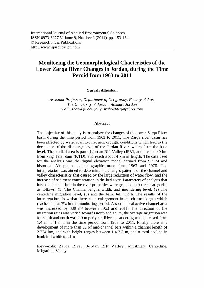
Fig. 2 slope map of the study area.
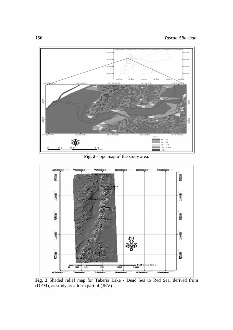
Fig. 3 Shaded relief map for Taberia Lake - Dead Sea to Red Sea, derived from (DEM), as study area form part of (JRV).

Monitoring the Geomorphological Chacteristics 157
2.1-Data sources and Methodology Analysis of the river variables was includes the channel width, length, sinuosity, and centerline migration. Measuring the river variables and dimensions of the channel and valley was based on the topographic maps, aerial photography and DEM derived from (SRTM) data. Details of the data are shown below. The earliest available topographic map called Damea with scale of 1: 25, 000; was produced by Jordanian Survey Department in 1963. This map is consider the base map of the study area showing the dimensions of valley, and channel network before the establishment of the King Talal Dam. The Ariel photographs of 1978 were produced by the Royal Jordanian Geographic Center. The Ariel photo and maps were scanned and georectified using the georeferencing tools available in ARCGIS, the ground control points (GCPs) that used for rectification process were obtained from topographic maps. The third source is the DEM derived from Shuttle Radar Topographic Mission (SRTM) with 30 meter ground resolution. The digital elevation model (DEM) was used to analyze the channel and valley properties and variables along the river pathway. 3.1Research importance and objectives Jordan has limited water resources and high population growth and its classified as the most Arab countries that suffers from water scarcity in the region. Zarqa River is the thired bigest river in Jordan and it suffering from drougth and pullutions since the beginning of the eighties of the twentieth century. King Talal Dam was constructed in 1977 with 108 m height and have storage capacity about 75 MCM. The Dam region forms the local base level for the Zarqa river basin [21] and it connected to the King Abdullah Canal. The study area is considered as a part of the Jordan Reft Valley (JRV), and reach to the Dead Sea as the ultimate base level which is suffer from significant reduction in inflow value and a drop of about -23 m in mean sea level [22].The objectives of this study are to assess the recent dynamics of changes in the floodplain over the monitoring period from 1963 to 2011, and to investigate the impact of decreasing discharge level as results of establishment of King Talal dam and successive drought cycles. In addition to analyse the impact of decreasing the amount of water discharge on the river dimensions (e.g. length, width, centerline miggration), and to compare the variation between channel dimensions during the study period. Results and Discussion: This section discuss the changes of the Channel dimensions in terms of length; width, meandering, and Centerline migration parameters during the monitoring periods. 1:2 – Changes in the active channel characteristics: A: Active channel length (ACL), and area (ACA): The value of the active channel length in 1963 which is the base year was 5.224 Km, and it was increased by 342 M in 1978 and up to 5.611 Km in 2011. The total increment of change is 387 m or about 7% during the monitoring time. The reason of

158 Yusrah Alhusban
this change is the decrease in the amount of water discharge, and the decreasing of the river power in both vertical and lateral dimension. This also led to increasing the channel meandering from 1.4 to 1.5 and 1.8 respectively. The area of the active channel has been increased by 27% between 1963 and 2011 as shown in fig (6). These changes in length and area form a type of the channel adjustment [23]. B: Active channel migration (center line): Channel activity is measured by the rate and direction of migration. In order to determine the channel migration rate and direction ten test locations were examined for the 1963, 1978 and 2011. The results showed that the direction of active channel migration is concentrated towards North, with mean rate of channel centerline migration about 2.9 m\year between 1963 and 201. The position of channel centerline for 1963 was began towards the north with only a 54 m from the north bank, then it meander into southern direction within a distance of 2.5 km, where closed to South Bank completely. There is a general trend for the center channel in 1963 is directed southward, comparing with for active Channel in 1978, the measurement showed that the total migration towards northern about 1042m, and 450m towards southward, which means that about 1492 m, represent as abandoned channel between 1963 and 1978, and the rest represents as stable active channel, then it joins into the Jordan River at a distance of 2m northern former. In 2011 the total channel migration is towards the southern direction with a value of 463 m, and 1616 m towards northern. The general trend of Channel River migration in 2011 is toward northward, and then is join into its estuary Jordan River northern former with about 15 m. Figure (4) shows the location of the active channel in related to the base year of 1963. Many studies have been focused on the effect of changing water discharge, slope, and bed sediment on the mobility of channel by migration, one of the most important factors responsible for this trend in immigration is that the majority of gradient aspect is towards the northeast [6].
Fig. 4 Channel centerline migrations in related to base year 1963.

Monitoring the Geomorphological Chacteristics 159
C- Center line location in related to valley center: In order to determent the position of the active channel center line in related to valley center ten points were chosen for the analysis as shown in Fig. 5. The measurements showed that there were a significant changes and shifting (migration) in the active channel center line toward south and north from the valley center. In the base year of 1963 about 1.802 kilometers of the total active channel located northern of valley center line was mapped, while 2.432 kilometers southern of valley center line was measured. This means that the general trend for the active channel position is southern from the valley centerline. In comparison of 1978 with 1963, it found that about 1.780 kilometers is located northern direction from the valley center line, and 2.947 kilometers toward southern direction. Finally in 2011 the total migration direction towards northern is about 2.399 kilometers, while the amount of migration direction towards southern is 1.242 kilometers. This means that the general trend for active channel heading position and migration northward, the rest with relative stability. These dynamics of channel and meandering is due to the changes in water discharge, gradient as shown in Fig. (4).
Fig. 5 Active Channel location related to valley center.

160 Yusrah Alhusban
D- Changes in channel Meandering: Over the last century, freely meandering channels have attracted a great deal of attention from morphologists [14]. The meandering channel was calculated in ten channel segments and presented in Figure (6). The purpose is to determine the changing in meandering level during 1963 and 2011. The channel meandering explains the relationship between the length of the channel and the length of the valley. (P (sinuosity) =LC/LV) [21], the channel could be considered as meander if the meander value increases more than 1.5. The measurements showed that there were changes in the mean channel meandering from 1.4m in 1963 to 1.5m in 1994 and 1.8m in 2011. The result of development show that there are more than 22 of mid-channel bars with a total of 2.324 km length, and with height ranges between (1.4 - 2.3) m during the monitoring time. The meandering changes is classified as an irregular patterns and the curved shape was the common one among the river meandering[24]Figure (5, 6) showed the river channel meandering, and meander belt width with significant changes between 1963 and 2011. The meandering shows a pattern of adjustment for the reduction of water discharge, geological structure, and increasing the valley bed height due to the sediment accumulation[3, 5, 15].The factors that controlled this mobility of active channel are: (1). geomorphical controls, relief, slope, aspect. (2). lithology structure. The rate of reduction in Bank full width depends on the geological controls surrounding the banks and representing by Holocene deposit[24]This covers all the study area including the ruggedness and high salinity badlands. In addition to the reduction of flow after constructions of King Talal Dam in 1977, which cause reduction of stream power, and security of peak floods.
Fig. 6 Changes in channel meandering (1963-2011). E-Abandoned channel in freely meandering: One of the most common landscape development in floodplain is the abandoned
Monitoring the Geomorphological Chacteristics 161
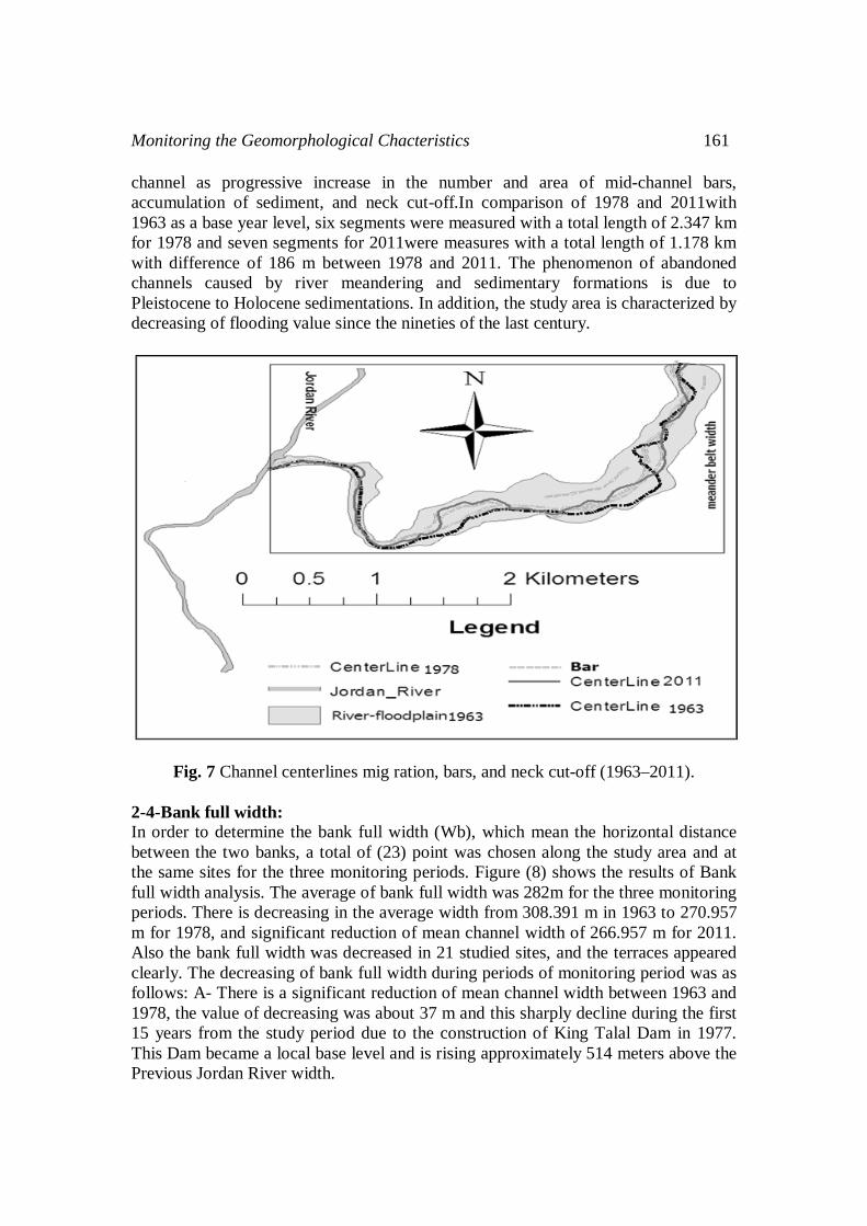
channel as progressive increase in the number and area of mid-channel bars, accumulation of sediment, and neck cut-off.In comparison of 1978 and 2011with 1963 as a base year level, six segments were measured with a total length of 2.347 km for 1978 and seven segments for 2011were measures with a total length of 1.178 km with difference of 186 m between 1978 and 2011. The phenomenon of abandoned channels caused by river meandering and sedimentary formations is due to Pleistocene to Holocene sedimentations. In addition, the study area is characterized by decreasing of flooding value since the nineties of the last century.
Fig. 7 Channel centerlines mig ration, bars, and neck cut-off (1963–2011). 2-4-Bank full width: In order to determine the bank full width (Wb), which mean the horizontal distance between the two banks, a total of (23) point was chosen along the study area and at the same sites for the three monitoring periods. Figure (8) shows the results of Bank full width analysis. The average of bank full width was 282m for the three monitoring periods. There is decreasing in the average width from 308.391 m in 1963 to 270.957 m for 1978, and significant reduction of mean channel width of 266.957 m for 2011. Also the bank full width was decreased in 21 studied sites, and the terraces appeared clearly. The decreasing of bank full width during periods of monitoring period was as follows: A- There is a significant reduction of mean channel width between 1963 and 1978, the value of decreasing was about 37 m and this sharply decline during the first 15 years from the study period due to the construction of King Talal Dam in 1977. This Dam became a local base level and is rising approximately 514 meters above the Previous Jordan River width.
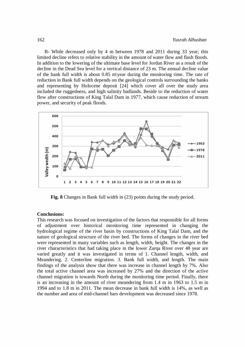
162 Yusrah Alhusban
B- While decreased only by 4 m between 1978 and 2011 during 33 year; this limited decline refers to relative stability in the amount of water flow and flash floods. In addition to the lowering of the ultimate base level for Jordan River as a result of the decline in the Dead Sea level for a vertical distance of 23 m. The annual decline value of the bank full width is about 0.85 m\year during the monitoring time. The rate of reduction in Bank full width depends on the geological controls surrounding the banks and representing by Holocene deposit [24] which cover all over the study area included the ruggedness, and high salinity badlands. Beside to the reduction of water flow after constructions of King Talal Dam in 1977, which cause reduction of stream power, and security of peak floods.
Fig. 8 Changes in Bank full width in (23) points during the study period. Conclusions: This research was focused on investigation of the factors that responsible for all forms of adjustment over historical monitoring time represented in changing the hydrological regime of the river basin by constructions of King Talal Dam, and the nature of geological structure of the river bed. The forms of changes in the river bed were represented in many variables such as length, width, height. The changes in the river characteristics that had taking place in the lower Zarqa River over 48 year are varied greatly and it was investigated in terms of 1. Channel length, width, and Meandering. 2. Centerline migration. 3. Bank full width, and length. The main findings of the analysis show that there was increase in channel length by 7%. Also the total active channel area was increased by 27% and the direction of the active channel migration is towards North during the monitoring time period. Finally, there is an increasing in the amount of river meandering from 1.4 m in 1963 to 1.5 m in 1994 and to 1.8 m in 2011. The mean decrease in bank full width is 14%, as well as the number and area of mid-channel bars development was decreased since 1978.

Monitoring the Geomorphological Chacteristics 163
References
[1] Ministry of Environment, the Hashemite Kingdom of Jordan, 2006, a proposal for restoration of the Zarqa River, the integrated environmental management of the Zarqa River, P.1-50.
[2] Brandt, S.A, 2000, Classification of geomorphological effects-downstream of dams, Catena 40, 375–401.
[3] Gregory K.J., 2006, The human role in changing river channels, Geomorphology 79, 172–191.
[4] Chen D., Duan J.G., 2006, modeling width adjustment in meandering channels, Journal of Hydrology 321, 59–76.
[5] Beechie.T.J, Martin Liermann, Michael M. Pollock, Sarah Baker, Jeremy Davies, 2006, Channel pattern and river-floodplain dynamics in forested mountain river systems, Geomorphology 78, 124–141.p127.
[6] Pohl M., 2004, Channel Bed Mobility Downstream from the Elwha Dams, Washington The Professional Geographer, 56(3) 2004, pages 422–431.
[7] Hooke J.M, 1995, River channel adjustment to meander cutoffs on the River Bollin and River Dane, northwest England, Geomorphology 14, 235-253.p236.
[8] Paul E.G., ; Schmidt, John C, 2002, Streamflow regulation and multi-level flood plain formation: channel narrowing on the aggrading Green River in the eastern Uinta Mountains, Colorado and Utah, Geomorphology, 4 4, 337–360.
[9] Fan H, Haijun Huang, Thomas Q. Zeng, Kairong Wang, 2006, River mouth bar formation, riverbed aggradation and channel migration in the modern Huanghe (Yellow) River delta, China Geomorphology 74, 124– 136.p128.
[10] Musselman.Z.A, 2011, The localized role of base level lowering on channel adjustment of tributary streams in the Trinity River basin downstream of Livingston Dam, Texas, USA, Geomorphology, 128, 42-56.
[11] Kolla V., 2007, a review of sinuous channel avulsion patterns in some major deep-sea fans and factors controlling them, Marine and Petroleum Geology 24, 450–469.
[12] Jiongxin Xu Michiel C. J. Damen & Robert A. van Zuidam, 2002, River sedimentation and channel adjustment of the lower Yellow River as influenced by low discharges and seasonal channel dry-ups, Geomorphology 43, 151– 164.p152.
[13] Nicoll.T. J.and Hickin.E J. 2010, Planform geometry and channel migration of confined meandering rivers on the Canadian prairies, Geomorphology 116, 37–47.
[14] Magdaleno F., Fernández-Yuste j A., 2011, Meander dynamics in a changing river corridor, Geomorphology 130, 197–207.
[15] Hong II., Joongu Kang, Hongkoo Yeo, Yonguk Ryu, 2011, Channel Response Prediction for Abandoned Channel Restoration and Applicability Analysis, Engineering, 2011, 3, 461-469.
[16] Malik I, 2005, Rates of lateral channel migration along the Mala Panew River (southern Poland) based on dating riparian trees and Coarse Woody Debris, Dendrochronologia 23, 29–38.

164 Yusrah Alhusban
[17] Bender, 1974, Geology of Jordan (1968, 1974), Natural Resources Authority, and German Geological Mission in Jordan, Hanover, Germany.
[18] The hashemite Kingdam of Jordan, Ministry of Agriculture, commission of the European contract, National Soil Map, and land use project (The soil of Jordan), level 1, Vol.2, Main Report.1994. p.183
[19] The Ministry of Water and Irrigation, 2010, unpublished data. [20] op.sit.p.13-14 [21] Hassan, M.A., and Klein, M., 2002, Fluvial adjustment of the lower Jordan
River to a drop in the Dead Sea level, Geomorphology, 45 21-33. [22] William L., and Graf, 2006, downstream hydrologic and geomorphic effects of
large dams on American rivers, Geomorphology 79 (2006) 336–360. [23] op.sit.p.432. [24] op.sit.p265. [25] (Report to, Toronto &Region Conservation Authority, 2004, Belt width
Delineation procedures, p5, 6, 12. [26] Op.Sit.P5. [27] O’Connora, J.E., Myrtle A. Jones, Tana L. Haluska, , 2003, Flood plain and
channel dynamics of the Quinault and Queets Rivers, Washington, USA, Geomorphology 51, 31–59.
[28] Op.Sit.P.23. [29] Hassan Ramadan H., , Auda S., , 1986, geomorphologic Katar around the lower
part of the Zarqa River, Human and Social Sciences, Volume 13, Issue 7, pp. 23-61.