Monitoring of rainfall and soil moisture at the Rebaixader ...
7
_________ * Corresponding author e-mail address: [email protected] 7 th International Conference on Debris-Flow Hazards Mitigation Monitoring of rainfall and soil moisture at the Rebaixader catchment (Central Pyrenees) Marcel Hürlimann a, *, Raül Oorthuis a , Clàudia Abancó a,b , Luigi Carleo c , José Moya a a Department of Civil and Environmental Engineering, UPC BarcelonaTECH, Jordi Girona 1-3, 08034 Barcelona, Spain b Institut Cartogràfic i Geològic de Catalunya, Parc de Montjuïc, 08038 Barcelona, Spain c Department of Civil Engineering, University of Salerno, Via Giovanni Paolo II 132, 84084 Fisciano, Italy Abstract The instrumental monitoring of torrential catchments is a fundamental research task and provides necessary information to improve our understanding on the mechanisms of debris flows. While most monitoring sites include meteorological sensors and analyze the critical rainfall conditions, only very few contain soil moisture measurements. In our monitoring site, the Rebaixader catchment, 11 debris flows and 24 debris floods were detected during the last nine years. Herein, the initiation mechanisms of these torrential flows were analyzed focusing on the critical rainfall conditions and the soil water dynamics. Comparing the temporal distribution of both rainfall episodes and torrential flows, the Kernel density plots showed maximum values for rainfalls at the beginning of June, while the peak for torrential flows is at July 20 th . This means that highest probability of debris flows and debris floods triggering is about 1.5 months later than the one of rainstorms in the catchment. Thus, the antecedent rainfall and especially the soil moisture conditions may influence the triggering of torrential flows. In a second step, a new updated rainfall threshold was proposed including total rainfall duration and mean intensity. The analysis of soil moisture data was more complicated and no clear trends were observed in the dataset. Therefore, additional data has to be recorded in order to quantitatively analyze the role of soil moisture on the triggering of flows and for the definition of thresholds. Some preliminary results show that the soil moisture at the beginning of a rainfall event affects the maximum increase of soil moisture, while a slight trend was visible comparing the initial soil moisture with the necessary rainfall amount to trigger a torrential flow. Keywords: monitoring; rainfall infiltration; soil moisture; threshold; Pyrenees 1. Introduction Detailed data recorded at catchments with monitoring systems are necessary to improve our knowledge about the triggering mechanisms of debris flows and other torrential processes. Herein, we present data recorded at the Rebaixader torrent, where torrential activity is high and a comprehensive time series on the initiation of debris flows and debris floods is available. In this study, we distinguish between the torrential flows using the classification of Hungr et al. (2001, 2014). There are three principal approaches to monitor and analyze debris-flows triggering. The most common approach focuses on rainfall measurements and generally defines thresholds for debris-flow triggering (e.g. Abancó et al., 2016; Bel et al., 2017; Coe et al., 2008; Deganutti et al., 2000). The second approach analyses the soil water dynamics by recording moisture and/or pore water pressure in natural slopes of the catchment (e.g. Comiti et al., 2014) or in the channel bed (McCoy et al., 2012). The third approach investigates the channel discharge (e.g. Gregoretti et al., 2016). The present investigation focusses on the rainfall and the soil moisture measured at the Rebaixader catchment. The rainfall time-series covers the last 10 debris flow seasons (2009 to 2018), while the soil moisture records started in 131
Transcript of Monitoring of rainfall and soil moisture at the Rebaixader ...
_________
* Corresponding author e-mail address: [email protected]
7th International Conference on Debris-Flow Hazards Mitigation
Monitoring of rainfall and soil moisture at the Rebaixader catchment (Central Pyrenees)
Marcel Hürlimanna,*, Raül Oorthuisa, Clàudia Abancóa,b, Luigi Carleoc, José Moyaa
a Department of Civil and Environmental Engineering, UPC BarcelonaTECH, Jordi Girona 1-3, 08034 Barcelona, Spain b Institut Cartogràfic i Geològic de Catalunya, Parc de Montjuïc, 08038 Barcelona, Spain
c Department of Civil Engineering, University of Salerno, Via Giovanni Paolo II 132, 84084 Fisciano, Italy
Abstract
The instrumental monitoring of torrential catchments is a fundamental research task and provides necessary information to improve our understanding on the mechanisms of debris flows. While most monitoring sites include meteorological sensors and analyze the critical rainfall conditions, only very few contain soil moisture measurements. In our monitoring site, the Rebaixader catchment, 11 debris flows and 24 debris floods were detected during the last nine years. Herein, the initiation mechanisms of these torrential flows were analyzed focusing on the critical rainfall conditions and the soil water dynamics. Comparing the temporal distribution of both rainfall episodes and torrential flows, the Kernel density plots showed maximum values for rainfalls at the beginning of June, while the peak for torrential flows is at July 20th. This means that highest probability of debris flows and debris floods triggering is about 1.5 months later than the one of rainstorms in the catchment. Thus, the antecedent rainfall and especially the soil moisture conditions may influence the triggering of torrential flows. In a second step, a new updated rainfall threshold was proposed including total rainfall duration and mean intensity. The analysis of soil moisture data was more complicated and no clear trends were observed in the dataset. Therefore, additional data has to be recorded in order to quantitatively analyze the role of soil moisture on the triggering of flows and for the definition of thresholds. Some preliminary results show that the soil moisture at the beginning of a rainfall event affects the maximum increase of soil moisture, while a slight trend was visible comparing the initial soil moisture with the necessary rainfall amount to trigger a torrential flow.
Keywords: monitoring; rainfall infiltration; soil moisture; threshold; Pyrenees
1. Introduction
Detailed data recorded at catchments with monitoring systems are necessary to improve our knowledge about thetriggering mechanisms of debris flows and other torrential processes. Herein, we present data recorded at the Rebaixader torrent, where torrential activity is high and a comprehensive time series on the initiation of debris flows and debris floods is available. In this study, we distinguish between the torrential flows using the classification of Hungr et al. (2001, 2014).
There are three principal approaches to monitor and analyze debris-flows triggering. The most common approach focuses on rainfall measurements and generally defines thresholds for debris-flow triggering (e.g. Abancó et al., 2016; Bel et al., 2017; Coe et al., 2008; Deganutti et al., 2000). The second approach analyses the soil water dynamics by recording moisture and/or pore water pressure in natural slopes of the catchment (e.g. Comiti et al., 2014) or in the channel bed (McCoy et al., 2012). The third approach investigates the channel discharge (e.g. Gregoretti et al., 2016).
The present investigation focusses on the rainfall and the soil moisture measured at the Rebaixader catchment. The rainfall time-series covers the last 10 debris flow seasons (2009 to 2018), while the soil moisture records started in
131

Hürlimann / 7th International Conference on Debris-Flow Hazards Mitigation (2019)
2013. The main objective of the study is to improve our understanding on the initiation mechanisms of debris flows and debris floods. A secondary goal includes the definition of critical values or thresholds that are necessary information for the launch of early warning or alarm systems.
2. The Rebaixader monitoring site
2.1. Settings
The Rebaixader monitoring site is located in a small first order basin at the Southern Central Pyrenees, which shows a typical morphology of a torrential system (Fig. 1) developed in an old glacial valley. The catchment drains an area of 0.53 km2; the altitude ranges from 1350 m asl at the fan apex up to 2475 m asl at the highest peak. The debris flows and debris floods initiate in a steep bare scarp with a badland-like morphology and progresses to the channel zone. This latter is 150 m long and has a mean slope of 21º. At the bottom of the slope, the fan has area of 8.4 Ha and an average slope of 18º.
The bedrock consists of Palaeozoic slates and phyllites formed during Hercyanian orogeny (Muñoz, 1992), while the soils include colluvium and glacial deposits. The main scarp is located in a thick lateral till, which consists of sandy gravels, and provides almost unlimited sediment availability.
The climate conditions are affected by three principal factors: i) the west winds from the North-Atlantic, ii) the vicinity of the Mediterranean Sea; and, iii) the orographic effects of the Pyrenean mountain range. In the Pyrenees, the most common triggering rainfalls are on one side short duration and high intensity convective summer storms, and on the other side long-lasting rainfalls with moderate intensity during autumn (Hürlimann et al., 2003).
a) b)
Fig. 1. The Rebaixader monitoring site. (a) General view of the catchment with the open scarp, where the debris flows and debris floods initiate. (b) Situation of the monitoring stations used in this study (green dot indicates the rain gauge, light blue squares represent the infiltration stations and the red rectangle specifies the area where the sensors of the flow detection station are installed).
132

Hürlimann / 7th International Conference on Debris-Flow Hazards Mitigation (2019)
2.2. Monitoring description
The monitoring in the Rebaixader torrent started in summer 2009 and includes at the moment five different stations. In this study, we used records of the two meteorological stations METEO-CHA and METEO-TOP, two infiltration stations (INF-SCARP1 and INF-SCARP2) and the FLOW-WR station, which detects and identifies the different torrential flows (Fig. 1).
The principal rain gauge is METEO-CHA, which is installed in the lower part of the catchment. It is a standard tipping bucket rain gauge with a resolution of 0.2 mm (until 2015, the resolution was 0.1 mm). The rain gauge METEO-TOP was temporarily installed just above the main scarp and not used in this study. The infiltration stations are built in a steep (30-40º) bare slope at the highest part of the open scarp, which is actually stable but very close to the most active portion of the initiation zone. They consist of eight soil moisture sensors (Decagon 10HS) and two water potential sensors (Decagon MPS-2). This set-up is totally different to other sites in the literature, where soil moisture and pore water pressure are measured in the channel bed (McCoy et al., 2012). All of the monitoring stations have a sampling rate of 5 minutes.
The most important part of the monitoring system forms the FLOW-WR station, which detects and allows classifying the flows. Sensors in this station include five geophones, one ultrasonic device, one radar sensor and one video camera. All these devices are located in the channel reach or at the highest part of the fan (Fig.1) and register the data at 1 Hz. Detailed information on the monitoring system is available in Hürlimann et al. (2014).
3. Analysis of the rainfall data
Between July 2009 and September 2018 a total of 11 debris flows and 24 debris floods were observed. Rainfall data from METEO-CHA are available for all events except one debris flows, which was measured by METEO-TOP. Moreover, 446 rainfall episodes that did not trigger any important torrential flow were selected. Rainfall parameters like duration (D), total rainfall (Ptot), mean intensity (I) and maximum intensity for different durations (e.g. Imax_5min for 5 minute), were evaluated. An important and critical task during the rainfall analysis is the definition of the total rainfall duration. Herein, this parameter was determined by the condition that no rainfall was observed one hour before and after the episode.
In the first step, the rainfall events were analyzed searching for seasonal or cyclic patterns using Kernel density plots. The Kernel density is a method to estimate the density of a sample smoothly by removing the dependence of the end points of histogram bins centering the blocks at each data point (Duong, 2001). The temporal distribution of all the 481 rainfall episodes (both triggering torrential flows or not) is plotted in Figure 2a. The results show that the highest density for the rainfall episodes is at 14:00 UTC and between April and July, with a maximum at June 5. If this density plot is compared with the one of debris flows and debris floods occurrence (Fig. 2b), some interesting facts can be observed. First of all, the maximum Kernel density for the triggering of torrential flows is shifted 45 days to July 20 and the range of high density values is between June and August. In contrast, the maximum density of a trigger is approximately at the same hour as for the rainfall episodes (13:00 UTC). The difference of the temporal occurrence between rainfall and triggering of torrential flows (about 1.5 months) may be associated with the effects of antecedent rainfall and the soil moisture evolution during late spring and early summer. The importance of antecedent rainfall and the corresponding increase of soil moisture has been reported many times in debris-flow and landslide research (Gregoretti and Dalla Fontana, 2007; Wieczorek and Glade, 2005), but until now no clear relation between antecedent rainfall and debris-flow triggering was observed at Rebaixader (Abancó et al., 2016). Nevertheless, a possible effect of snowmelt cannot be neglected for debris flows that occur in late spring or early summer (Hürlimann et al., 2010; Abancó et al., 2016). It must be stated that additional information of rainfall (intensity, duration or total rainfall) was not incorporated in the density plot. However, the measurements gathered at Rebaixader confirm the hypothesis that debris flows are generally triggered in summer by convective rainstorms of short duration and high intensity, while long-lasting rainfalls during spring normally not provoke events (Hürlimann et al., 2014).
133
Hürlimann / 7th International Conference on Debris-Flow Hazards Mitigation (2019)
a)
b)
Fig. 2. Temporal distribution of rainfall and torrential activity. Kernel density plots of 481 rainfall episodes (a) and 35 debris-flow or debris-flood events (b).
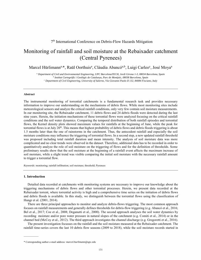
In the second step, the rainfall threshold for the triggering of torrential flows was assessed. Abancó et al. (2016) already proposed two thresholds for the data registered during 2009 and 2014. The present dataset includes additional records of the last four years. Therefore, the threshold for the relation between total duration and the mean intensity was reconsidered and updated. The new threshold line was defined applying the following procedure: first, a power-law trend line was fitted using the data of the 11 debris-flow triggering rainfalls. Then, the scale parameter defined in the previous step was reduced, keeping constant the exponent, until all the debris flows were located above the threshold line. The new updated threshold can be expressed by
I = 11 D-0.74 (1)
, where I is the mean intensity (in mm/hours) and D is the duration (in hours) of the rainfall events. Although the rainfall events, which triggered debris floods, were not used to define the threshold, it is noteworthy that most of them are located above the threshold. Indeed, only four debris floods (usually of small volume) did not fulfill the threshold condition.
134

Hürlimann / 7th International Conference on Debris-Flow Hazards Mitigation (2019)
Fig. 3. Relation between total rainfall duration and mean intensity for debris flows/debris floods triggering and non-triggering (no-trig) events. The resulting threshold is illustrated by the red line and expressed in Eq. (1).
4. Analysis of the soil moisture data
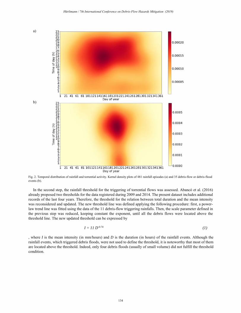
The analysis of the soil moisture due to rainfall infiltration focuses on the station with the longest record (INF-SCARP1). Figure 4 shows two examples of the soil moisture response during rainfalls that produced torrential flows. The soil moisture is given by the volumetric water content (VWC) and is measured at three different depths (-15, -30 and -50 cm). The first case shows the fast response and sharp increase of the VWC at the three depths due to a short and intense rainstorm (Ptot = 15.8 mm in 3.3 h) that triggered a large debris flow of about 10000 m3. The second example illustrates the soil moisture response during a rainfall with a longer duration and smaller intensity (Ptot = 54.5 mm in 7h), which triggered two debris floods with a total volume of about 2000 m3. In this case, the VWC slowly increased during about 2 – 3 h and maximum values were generally lower than in the first example, although the total rainfall is more than three times higher. A significant time lag occurred between the start of the rainfall and the increase of VWC.
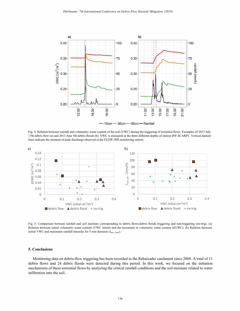
Unfortunately, soil moisture measurements are not available for all the debris flows and debris floods occurred in the site. Technical problems have been occurring many times, since maintenance is complicated in such a remote high-mountain environment and because processes like soil thawing and freezing, rock falls and other slope instabilities are very common. Nevertheless, a complete record of rainfall and soil moisture is available for seven of the torrential events (three debris flows and four debris floods). Figure 5 shows the soil moisture values measured at -30 cm at INF-SCARP1. The seven events are compared with soil moisture data from non-triggering rainfalls, which were selected for Imax_5min-values larger than 35 mm/h.
The relation between the initial VWC before the rainfall and the increment of VWC due to the rainfall is presented in Figure 5a. A tentative trend is observed for the rainfalls that triggered torrential flows: a larger increase of soil moisture was measured when the soil was dryer at the beginning of the rainfall. In addition, maximum rainfall intensity recorded in 5 min were compared with the initial VWC (Figure 5b). A slight trend might be identified, which show that smaller rainfall is needed to trigger debris flows when the initial VWC is higher. Such a pattern was already observed during a rainfall analysis in Italy (Gregoretti and Dalla Fontana, 2007).
135
Hürlimann / 7th International Conference on Debris-Flow Hazards Mitigation (2019)
Fig. 4. Relation between rainfall and volumetric water content of the soil (VWC) during the triggering of torrential flows. Examples of 2013 July 17th debris flow (a) and 2013 June 5th debris floods (b). VWC is measured at the three different depths of station INF-SCARP1. Vertical dashed lines indicate the moment of peak discharge observed at the FLOW-WR monitoring station.
a) b)
Fig. 5. Comparison between rainfall and soil moisture corresponding to debris flows/debris floods triggering and non-triggering (no-trig). (a) Relation between initial volumetric water content (VWC initial) and the increment in volumetric water content (ΔVWC). (b) Relation between initial VWC and maximum rainfall intensity for 5 min duration (Imax_5min).
5. Conclusions
Monitoring data on debris-flow triggering has been recorded in the Rebaixader catchment since 2009. A total of 11debris flows and 24 debris floods were detected during this period. In this work, we focused on the initiation mechanisms of these torrential flows by analyzing the critical rainfall conditions and the soil moisture related to water infiltration into the soil.
136
Hürlimann / 7th International Conference on Debris-Flow Hazards Mitigation (2019)
The results show that most of the torrential flows in the test site occurred in summer (between June and August) and at around 13:00 UTC. In contrast, the highest probability of rainstorms is about 1.5 months earlier (between April and July), which supports the hypothesis that antecedent rainfall, snowmelt and/or soil moisture conditions are important for debris-flow triggering. The intensity and duration of rainfall is not included in this analysis, but previous studies at Rebaixader showed that most debris flows are provoked by short and intense rainstorms in summer, while spring rainfalls of lower intensity and longer duration normally do not trigger debris flows. In addition, a new updated threshold was defined including total duration and mean intensity of the rainfalls.
Regarding the soil water dynamics, the VWC changes during rainstorms were analyzed. Preliminary results show that a higher soil moisture increment is produced when the soil is dryer at the beginning of a rainstorm. Comparing rainfall and soil moisture measurements, the data indicate that the maximum 5 minutes rainfall intensities required for the triggering of torrential flows are generally larger than the non-triggering rainfalls, as it could be expected. Moreover, it seems that the initial soil moisture content affects the values of the triggering rainfalls and smaller rainfall amounts are necessary to trigger a torrential flow when soil moisture content is higher at the beginning of the rainstorm. However, a complete data set is available only for a small number of events. Therefore, additional data are necessary to confirm the former hypothesis and to define threshold values of soil moisture causing torrential flows.
Acknowledgements
The study is funded by the national research project called “Slope mass-wasting under climate change (SMuCPhy)” granted by the Spain Government (project reference number BIA 2015-67500-R) and co-funded by AEI/FEDER, UE and the EC H2020 project ANYWHERE (DRS-01-2015-700099).
References
Abancó, C., Hürlimann, M., Moya, J. and Berenguer, M., 2016, Critical rainfall conditions for the initiation of torrential flows. Results from the Rebaixader catchment (Central Pyrenees): J. Hydrol., p. 541, 218–229, doi:10.1016/j.jhydrol.2016.01.019.
Bel, C., Liébault, F., Navratil, O., Eckert, N., Bellot, H., Fontaine, F. and Laigle, D., 2017, Rainfall control of debris-flow triggering in the Réal Torrent, Southern French Prealps: Geomorphology, 291, p. 17–32.
Coe, J. A., Kinner, D. A. and Godt, J. W., 2008, Initiation conditions for debris flows generated by runoff at Chalk Cliffs, central Colorado: Geomorphology, 96(3–4), p. 270–297.
Comiti, F., Marchi, L., Macconi, P., Arattano, M., Bertoldi, G., Borga, M., Brardinoni, F., Cavalli, M., D’Agostino, V., Penna, D. and Theule, J., 2014, A new monitoring station for debris flows in the European Alps: first observations in the Gadria basin: Nat. Hazards, 73(3), p. 1175–1198, doi:10.1007/s11069-014-1088-5.
Deganutti, A. M., Marchi, L. and Arattano, M., 2000, Rainfall and debris-flow occurrence in the Moscardo basin (Italian Alps), in Proceedings, Debris-Flow Hazards Mitigation: Mechanics Prediction and Assessment, Taipei, Taiwan, Balkema, p. 67–72,.
Duong, T., 2001, Notes of seminar at Weatherburn Lecture Series for the Department of Mathematics and Statistics, University of Western Australia, 24th May 2001
Gregoretti, C. and Dalla Fontana, G., 2007, Rainfall threshold for the initiation of debris flows by channel bed failure of the Dolomites, in Proceedings, Debris-Flow Hazards Mitigation: Mechanics Prediction and Assessment. Chengdu, China, Millpress, p. 11–21.
Gregoretti, C., Degetto, M., Bernard, M., Crucil, G., Pimazzoni, A., De Vido, G., Berti, M., Simoni, A. and Lanzoni, S., 2016, Runoff of small rocky headwater catchments: Field observations and hydrological modeling: Water Resour. Res., 52(10), p. 8138–8158, doi:10.1002/2016WR018675.
Hungr, O., Evans, S. G., Bovis, M. J. and Hutchinson, J. N., 2001, A review of the classification of landslides of the flow type: Environ. Eng. Geosci., 7(3), p. 221–238.
Hungr, O., Leroueil, S. and Picarelli, L., 2014, The Varnes classification of landslide types, an update: Landslides, 11(2), p. 167–194, doi:10.1007/s10346-013-0436-y.
Hürlimann, M., Corominas, J., Moya, J. and Copons, R., 2003, Debris-flow events in the Eastern Pyrenees. Preliminary study on initiation and propagation, in Proceedings, Debris-Flow Hazards Mitigation: Mechanics Prediction and Assessment, Davos, Switzerland, Millpress, p. 115–126.
Hürlimann, M., Abancó, C. and Moya, J., 2010, Debris-flow initiation affected by snowmelt. Case study of the Senet monitoring site, Eastern Pyrenees, in Proceedings, Mountain Risks: Bringing Science to Society, Florence, Italy, p. 81–86.
Hürlimann, M., Abancó, C., Moya, J. and Vilajosana, I., 2014, Results and experiences gathered at the Rebaixader debris-flow monitoring site, Central Pyrenees, Spain: Landslides, 11, p. 939–953.
McCoy, S.W., Kean, J.W., Coe, J.A., Tucker, G.E., Staley, D.M., and Wasklewicz, T.A., 2012, Sediment entrainment by debris flows: In situ measurements from the headwaters of a steep catchment: J. Geophys. Res. 117, F03016.
Muñoz, A., 1992, Evolution of a continental collision belt: ECORS-Pyrenees crustal balanced cross-section, in Thrust Tectonics, edited by McClay, K. R. ed., Thrust Tectonics, Chapman & Hall, pp. 235–246., Chapman & Hall.
137