MOIRA VOL 4H NTC 28April07 - DELWPdsewebapps.dse.vic.gov.au/Shared/ATSAttachment1... · MOIRA SHIRE...
21
MOIRA SHIRE STAGE TWO HERITAGE STUDY 2007 VOLUME FOUR of Five: HERITAGE PRECINCTS: COBRAM, NATHALIA NATHALIA TOWN CENTER PRECINCT Heritage Intelligence Pty Ltd: Architectural Historians: Professional Heritage and Design Consultants Director: Lorraine Huddle B.Architecture (Hons) Melb. ICOMOS 189 Contents SUPPORTING DOCUMENTATION Nathalia Town Centre PRECINCT LOCATION 190 • Precinct Boundaries and Map 190 HISTORICAL BACKGROUND 191 • List of Culturally Significant Places 191 • Historical Context 192 PHYSICAL DESCRIPTION 196 • Urban Design, Views and Foci 196 • Culturally Significant Places 198 STATEMENT OF CULTURAL SIGNIFICANCE 207 References: 209
Transcript of MOIRA VOL 4H NTC 28April07 - DELWPdsewebapps.dse.vic.gov.au/Shared/ATSAttachment1... · MOIRA SHIRE...
MOIRA SHIRE STAGE TWO HERITAGE STUDY 2007 VOLUME FOUR of Five: HERITAGE PRECINCTS: COBRAM, NATHALIA
NATHALIA TOWN CENTER PRECINCT
Heritage Intelligence Pty Ltd: Architectural Historians: Professional Heritage and Design Consultants Director: Lorraine Huddle B.Architecture (Hons) Melb. ICOMOS
189
Contents SUPPORTING DOCUMENTATION
Nathalia Town Centre PRECINCT LOCATION 190
• Precinct Boundaries and Map 190
HISTORICAL BACKGROUND 191 • List of Culturally Significant Places 191 • Historical Context 192
PHYSICAL DESCRIPTION 196
• Urban Design, Views and Foci 196 • Culturally Significant Places 198
STATEMENT OF CULTURAL SIGNIFICANCE 207 References: 209
MOIRA SHIRE STAGE TWO HERITAGE STUDY 2007 VOLUME FOUR of Five: HERITAGE PRECINCTS: COBRAM, NATHALIA
NATHALIA TOWN CENTER PRECINCT
Heritage Intelligence Pty Ltd: Architectural Historians: Professional Heritage and Design Consultants Director: Lorraine Huddle B.Architecture (Hons) Melb. ICOMOS
190
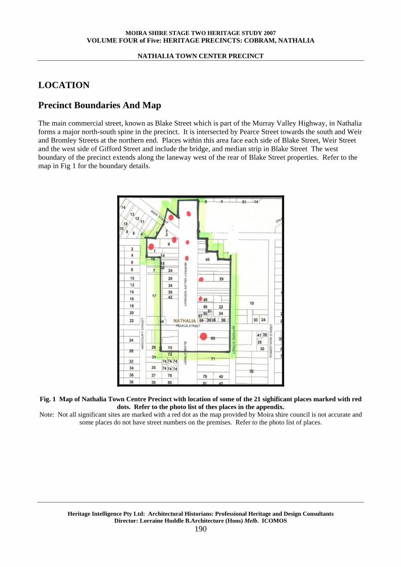
LOCATION Precinct Boundaries And Map The main commercial street, known as Blake Street which is part of the Murray Valley Highway, in Nathalia forms a major north-south spine in the precinct. It is intersected by Pearce Street towards the south and Weir and Bromley Streets at the northern end. Places within this area face each side of Blake Street, Weir Street and the west side of Gifford Street and include the bridge, and median strip in Blake Street The west boundary of the precinct extends along the laneway west of the rear of Blake Street properties. Refer to the map in Fig 1 for the boundary details.
Fig. 1 Map of Nathalia Town Centre Precinct with location of some of the 21 sighificant places marked with red
dots. Refer to the photo list of thes places in the appendix. Note: Not all significant sites are marked with a red dot as the map provided by Moira shire council is not accurate and
some places do not have street numbers on the premises. Refer to the photo list of places.
MOIRA SHIRE STAGE TWO HERITAGE STUDY 2007 VOLUME FOUR of Five: HERITAGE PRECINCTS: COBRAM, NATHALIA
NATHALIA TOWN CENTER PRECINCT
Heritage Intelligence Pty Ltd: Architectural Historians: Professional Heritage and Design Consultants Director: Lorraine Huddle B.Architecture (Hons) Melb. ICOMOS
191
HISTORICAL BACKGROUND Table One: List of Culturally Significant Places, their location , database number and historical context. Source Lorraine Huddle Pty Ltd 2006. Period Associated Historical
Themes Date Extant Places within the
Nathalia Town Centre Precinct
Location
Victorian 1880s to 1900
Early agricultural development; Expansion of Primary production Flour mills and commercial concerns. Beautification of Blake Street Development of local institutions. Infrastructure: Railways open 1888. Water Supply from Broken Creek
1882 1887 1889 1890 1891 1895 1898
Bridge Hotel Post & Telegraph Office Bank of Australasia Blake Street Reserve and Peppercorn Trees Nathalia Hotel Nathalia Herald Office Commercial Bank
Blake Street Blake Street Blake Street Blake Street Blake Street Blake Street Blake Street
Federation 1900s-1914
Infrastructure: Water Reticulation, Electricity and Fire Brigade.
1905 1905
Bridge Hotel alterations Courthouse Hotel
Blake Street Blake Street
Interwar 1920-30s
1921 1927 1937 1939 1941
State Savings Bank War Memorial Nathalia Bridge Water Tower Poplar Trees Avenue of Honour
Blake Street Blake Street Blake Street/ Weir St Broken Creek Blake Street Reserve Blake Street Reserve
Post War period 1946 - 1960s
Immigration; Soldier Settlement; improved irrigation and influx of new farmers. Population peak.
1950/60s
Remodelled shops
Blake Street Blake Street
MOIRA SHIRE STAGE TWO HERITAGE STUDY 2007 VOLUME FOUR of Five: HERITAGE PRECINCTS: COBRAM, NATHALIA
NATHALIA TOWN CENTER PRECINCT
Heritage Intelligence Pty Ltd: Architectural Historians: Professional Heritage and Design Consultants Director: Lorraine Huddle B.Architecture (Hons) Melb. ICOMOS
192
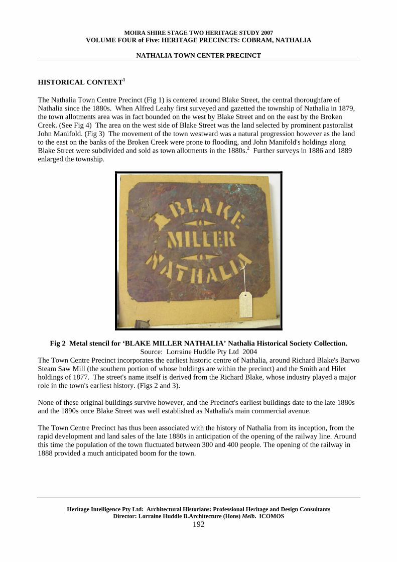
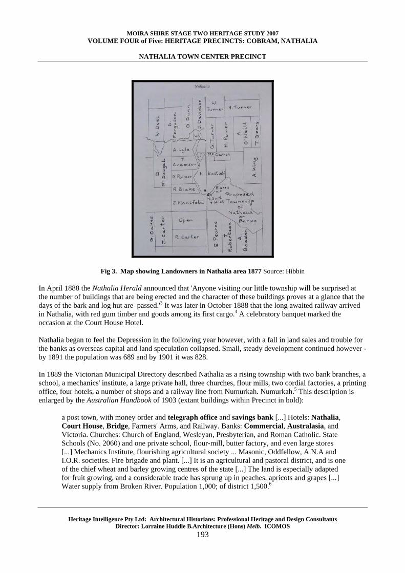
HISTORICAL CONTEXT1 The Nathalia Town Centre Precinct (Fig 1) is centered around Blake Street, the central thoroughfare of Nathalia since the 1880s. When Alfred Leahy first surveyed and gazetted the township of Nathalia in 1879, the town allotments area was in fact bounded on the west by Blake Street and on the east by the Broken Creek. (See Fig 4) The area on the west side of Blake Street was the land selected by prominent pastoralist John Manifold. (Fig 3) The movement of the town westward was a natural progression however as the land to the east on the banks of the Broken Creek were prone to flooding, and John Manifold's holdings along Blake Street were subdivided and sold as town allotments in the 1880s.2 Further surveys in 1886 and 1889 enlarged the township.
Fig 2 Metal stencil for ‘BLAKE MILLER NATHALIA’ Nathalia Historical Society Collection. Source: Lorraine Huddle Pty Ltd 2004
The Town Centre Precinct incorporates the earliest historic centre of Nathalia, around Richard Blake's Barwo Steam Saw Mill (the southern portion of whose holdings are within the precinct) and the Smith and Hilet holdings of 1877. The street's name itself is derived from the Richard Blake, whose industry played a major role in the town's earliest history. (Figs 2 and 3). None of these original buildings survive however, and the Precinct's earliest buildings date to the late 1880s and the 1890s once Blake Street was well established as Nathalia's main commercial avenue. The Town Centre Precinct has thus been associated with the history of Nathalia from its inception, from the rapid development and land sales of the late 1880s in anticipation of the opening of the railway line. Around this time the population of the town fluctuated between 300 and 400 people. The opening of the railway in 1888 provided a much anticipated boom for the town.
MOIRA SHIRE STAGE TWO HERITAGE STUDY 2007 VOLUME FOUR of Five: HERITAGE PRECINCTS: COBRAM, NATHALIA
NATHALIA TOWN CENTER PRECINCT
Heritage Intelligence Pty Ltd: Architectural Historians: Professional Heritage and Design Consultants Director: Lorraine Huddle B.Architecture (Hons) Melb. ICOMOS
193
Fig 3. Map showing Landowners in Nathalia area 1877 Source: Hibbin In April 1888 the Nathalia Herald announced that 'Anyone visiting our little township will be surprised at the number of buildings that are being erected and the character of these buildings proves at a glance that the days of the bark and log hut are passed.'3 It was later in October 1888 that the long awaited railway arrived in Nathalia, with red gum timber and goods among its first cargo.4 A celebratory banquet marked the occasion at the Court House Hotel. Nathalia began to feel the Depression in the following year however, with a fall in land sales and trouble for the banks as overseas capital and land speculation collapsed. Small, steady development continued however - by 1891 the population was 689 and by 1901 it was 828. In 1889 the Victorian Municipal Directory described Nathalia as a rising township with two bank branches, a school, a mechanics' institute, a large private hall, three churches, flour mills, two cordial factories, a printing office, four hotels, a number of shops and a railway line from Numurkah. Numurkah.5 This description is enlarged by the Australian Handbook of 1903 (extant buildings within Precinct in bold):
a post town, with money order and telegraph office and savings bank [...] Hotels: Nathalia, Court House, Bridge, Farmers' Arms, and Railway. Banks: Commercial, Australasia, and Victoria. Churches: Church of England, Wesleyan, Presbyterian, and Roman Catholic. State Schools (No. 2060) and one private school, flour-mill, butter factory, and even large stores [...] Mechanics Institute, flourishing agricultural society ... Masonic, Oddfellow, A.N.A and I.O.R. societies. Fire brigade and plant. [...] It is an agricultural and pastoral district, and is one of the chief wheat and barley growing centres of the state [...] The land is especially adapted for fruit growing, and a considerable trade has sprung up in peaches, apricots and grapes [...] Water supply from Broken River. Population 1,000; of district 1,500.6
MOIRA SHIRE STAGE TWO HERITAGE STUDY 2007 VOLUME FOUR of Five: HERITAGE PRECINCTS: COBRAM, NATHALIA
NATHALIA TOWN CENTER PRECINCT
Heritage Intelligence Pty Ltd: Architectural Historians: Professional Heritage and Design Consultants Director: Lorraine Huddle B.Architecture (Hons) Melb. ICOMOS
194
As an agricultural town, the fortunes of Nathalia were inextricable from those of its farming communities, and the history of the town was particularly affected by droughts such as those of 1908 and floods such as that of 1887. During and after the Great War of 1914-18 no less than 39 families left the area because of droughts, explaining the relatively staid population growth in the early twentieth century.7 Several floods also also affected the town during the early twentieth century.8
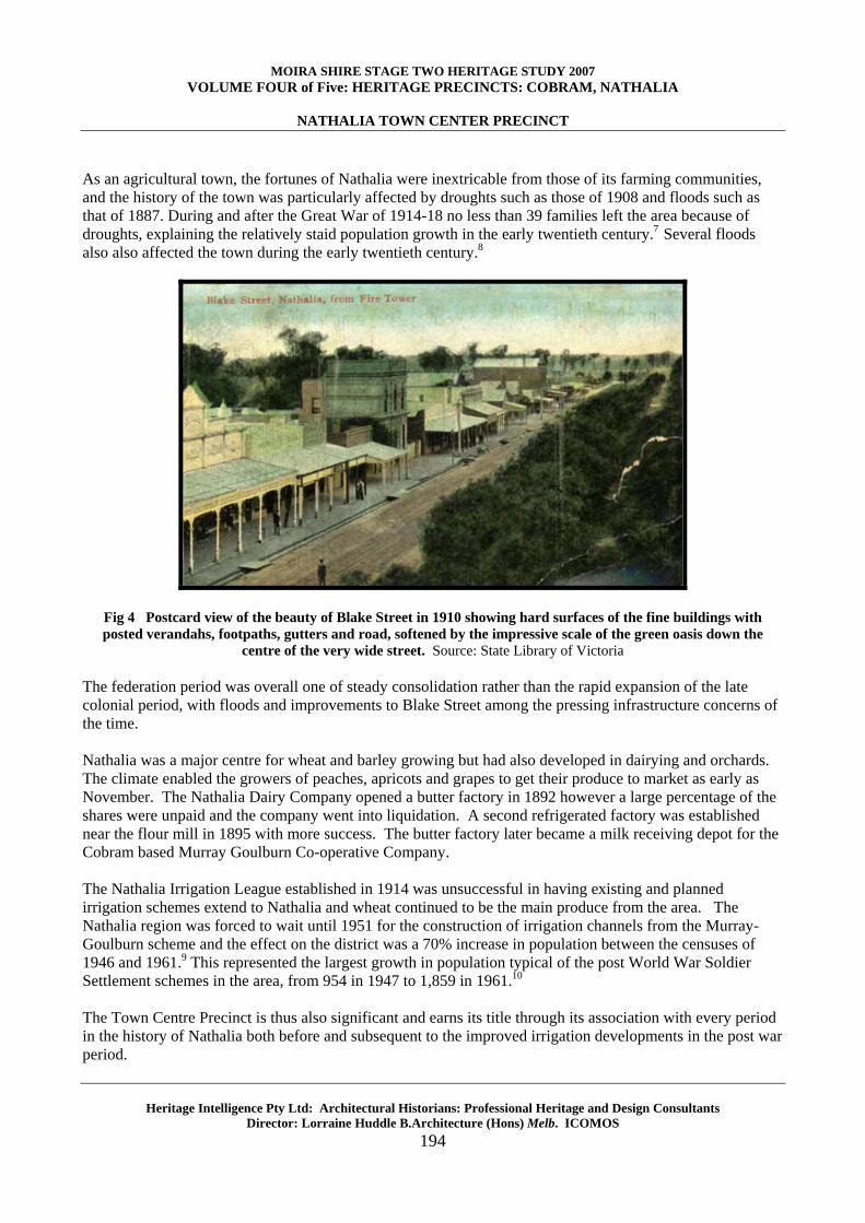
Fig 4 Postcard view of the beauty of Blake Street in 1910 showing hard surfaces of the fine buildings with posted verandahs, footpaths, gutters and road, softened by the impressive scale of the green oasis down the
centre of the very wide street. Source: State Library of Victoria The federation period was overall one of steady consolidation rather than the rapid expansion of the late colonial period, with floods and improvements to Blake Street among the pressing infrastructure concerns of the time. Nathalia was a major centre for wheat and barley growing but had also developed in dairying and orchards. The climate enabled the growers of peaches, apricots and grapes to get their produce to market as early as November. The Nathalia Dairy Company opened a butter factory in 1892 however a large percentage of the shares were unpaid and the company went into liquidation. A second refrigerated factory was established near the flour mill in 1895 with more success. The butter factory later became a milk receiving depot for the Cobram based Murray Goulburn Co-operative Company. The Nathalia Irrigation League established in 1914 was unsuccessful in having existing and planned irrigation schemes extend to Nathalia and wheat continued to be the main produce from the area. The Nathalia region was forced to wait until 1951 for the construction of irrigation channels from the Murray-Goulburn scheme and the effect on the district was a 70% increase in population between the censuses of 1946 and 1961.9 This represented the largest growth in population typical of the post World War Soldier Settlement schemes in the area, from 954 in 1947 to 1,859 in 1961.10 The Town Centre Precinct is thus also significant and earns its title through its association with every period in the history of Nathalia both before and subsequent to the improved irrigation developments in the post war period.
MOIRA SHIRE STAGE TWO HERITAGE STUDY 2007 VOLUME FOUR of Five: HERITAGE PRECINCTS: COBRAM, NATHALIA
NATHALIA TOWN CENTER PRECINCT
Heritage Intelligence Pty Ltd: Architectural Historians: Professional Heritage and Design Consultants Director: Lorraine Huddle B.Architecture (Hons) Melb. ICOMOS
195
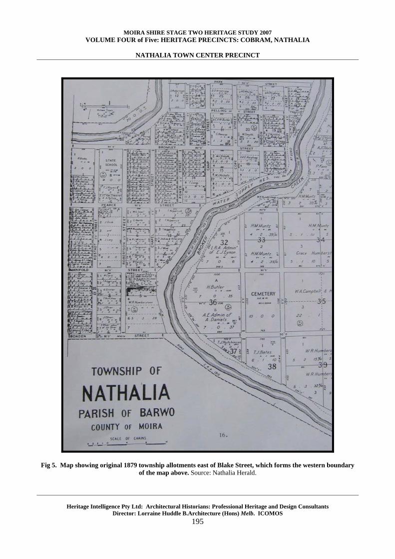
Fig 5. Map showing original 1879 township allotments east of Blake Street, which forms the western boundary
of the map above. Source: Nathalia Herald.
MOIRA SHIRE STAGE TWO HERITAGE STUDY 2007 VOLUME FOUR of Five: HERITAGE PRECINCTS: COBRAM, NATHALIA
NATHALIA TOWN CENTER PRECINCT
Heritage Intelligence Pty Ltd: Architectural Historians: Professional Heritage and Design Consultants Director: Lorraine Huddle B.Architecture (Hons) Melb. ICOMOS
196
PHYSICAL DESCRIPTION
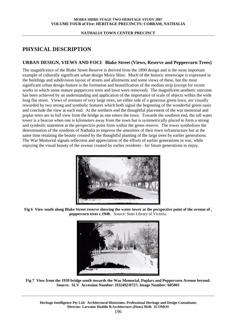
URBAN DESIGN, VIEWS AND FOCI Blake Street (Views, Reserve and Peppercorn Trees) The magnificence of the Blake Street Reserve is derived from the 1890 design and is the most important example of culturally significant urban design Moira Shire. Much of the historic streetscape is expressed in the buildings and subdivision layout of streets and allotments and some views of these, but the most significant urban design feature is the formation and beautification of the median strip (except for recent works in which some mature peppercorn trees and lawn were removed). The magnificent aesthetic outcome has been achieved by an understanding and application of the importance of scale of objects within the wide long flat street. Views of avenues of very large trees, set either side of a generous green lawn, are visually rewarded by two strong and symbolic features which both signal the beginning of the wonderful green oasis and conclude the view at each end. At the northern end the thoughtful placement of the war memorial and poplar trees are in full view from the bridge as one enters the town. Towards the southern end, the tall water tower is a beacon when one is kilometers away from the town but is symmetrically placed to form a strong and symbolic statement at the perspective point from within the green reserve. The tower symbolizes the determination of the residents of Nathalia to improve the amenities of their town infrastructure but at the same time retaining the beauty created by the thoughtful planting of the large trees by earlier generations. The War Memorial signals reflection and appreciation of the efforts of earlier generations in war, while enjoying the visual beauty of the avenue created by earlier residents - for future generations to enjoy.
Fig 6 View south along Blake Street reserve showing the water tower at the perspective point of the avenue of ,
peppercorn trees c.1940. Source: State Library of Victoria.
Fig 7 View from the 1939 bridge south towards the War Memorial, Poplars and Peppercorn Avenue beyond.
Source: SLV Accession Number: H32492/8727; Image Number: b05001
MOIRA SHIRE STAGE TWO HERITAGE STUDY 2007 VOLUME FOUR of Five: HERITAGE PRECINCTS: COBRAM, NATHALIA
NATHALIA TOWN CENTER PRECINCT
Heritage Intelligence Pty Ltd: Architectural Historians: Professional Heritage and Design Consultants Director: Lorraine Huddle B.Architecture (Hons) Melb. ICOMOS
197
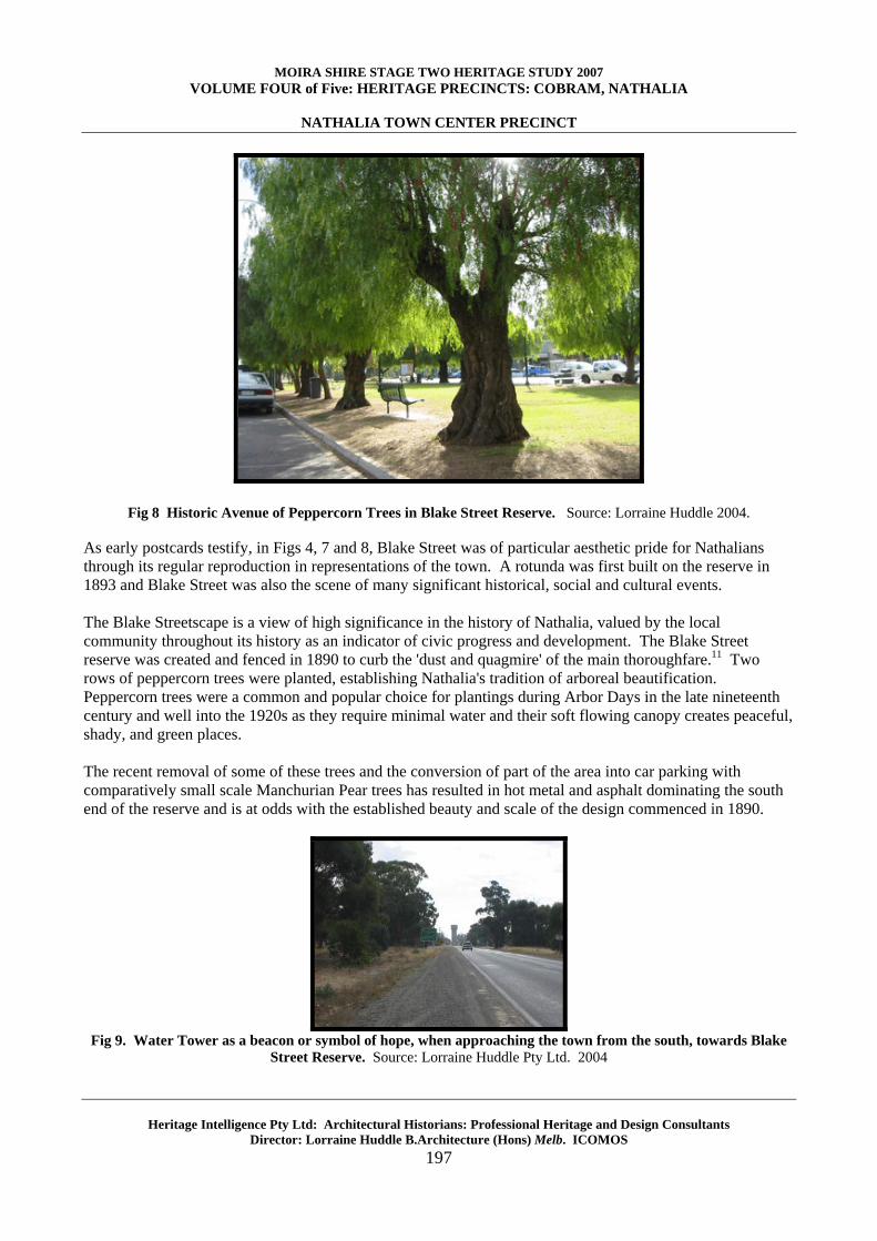
Fig 8 Historic Avenue of Peppercorn Trees in Blake Street Reserve. Source: Lorraine Huddle 2004. As early postcards testify, in Figs 4, 7 and 8, Blake Street was of particular aesthetic pride for Nathalians through its regular reproduction in representations of the town. A rotunda was first built on the reserve in 1893 and Blake Street was also the scene of many significant historical, social and cultural events. The Blake Streetscape is a view of high significance in the history of Nathalia, valued by the local community throughout its history as an indicator of civic progress and development. The Blake Street reserve was created and fenced in 1890 to curb the 'dust and quagmire' of the main thoroughfare.11 Two rows of peppercorn trees were planted, establishing Nathalia's tradition of arboreal beautification. Peppercorn trees were a common and popular choice for plantings during Arbor Days in the late nineteenth century and well into the 1920s as they require minimal water and their soft flowing canopy creates peaceful, shady, and green places. The recent removal of some of these trees and the conversion of part of the area into car parking with comparatively small scale Manchurian Pear trees has resulted in hot metal and asphalt dominating the south end of the reserve and is at odds with the established beauty and scale of the design commenced in 1890.
Fig 9. Water Tower as a beacon or symbol of hope, when approaching the town from the south, towards Blake
Street Reserve. Source: Lorraine Huddle Pty Ltd. 2004
MOIRA SHIRE STAGE TWO HERITAGE STUDY 2007 VOLUME FOUR of Five: HERITAGE PRECINCTS: COBRAM, NATHALIA
NATHALIA TOWN CENTER PRECINCT
Heritage Intelligence Pty Ltd: Architectural Historians: Professional Heritage and Design Consultants Director: Lorraine Huddle B.Architecture (Hons) Melb. ICOMOS
198
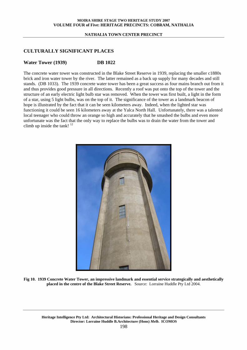
CULTURALLY SIGNIFICANT PLACES Water Tower (1939) DB 1022 The concrete water tower was constructed in the Blake Street Reserve in 1939, replacing the smaller c1880s brick and iron water tower by the river. The latter remained as a back up supply for many decades and still stands. (DB 1033). The 1939 concrete water tower has been a great success as four mains branch out from it and thus provides good pressure in all directions. Recently a roof was put onto the top of the tower and the structure of an early electric light bulb star was removed. When the tower was first built, a light in the form of a star, using 5 light bulbs, was on the top of it. The significance of the tower as a landmark beacon of hope is illustrated by the fact that it can be seen kilometers away. Indeed, when the lighted star was functioning it could be seen 16 kilometers away at the Yalca North Hall. Unfortunately, there was a talented local teenager who could throw an orange so high and accurately that he smashed the bulbs and even more unfortunate was the fact that the only way to replace the bulbs was to drain the water from the tower and climb up inside the tank! 12
Fig 10. 1939 Concrete Water Tower, an impressive landmark and essential service strategically and aesthetically
placed in the centre of the Blake Street Reserve. Source: Lorraine Huddle Pty Ltd 2004.
MOIRA SHIRE STAGE TWO HERITAGE STUDY 2007 VOLUME FOUR of Five: HERITAGE PRECINCTS: COBRAM, NATHALIA
NATHALIA TOWN CENTER PRECINCT
Heritage Intelligence Pty Ltd: Architectural Historians: Professional Heritage and Design Consultants Director: Lorraine Huddle B.Architecture (Hons) Melb. ICOMOS
199
War Memorial (1927)
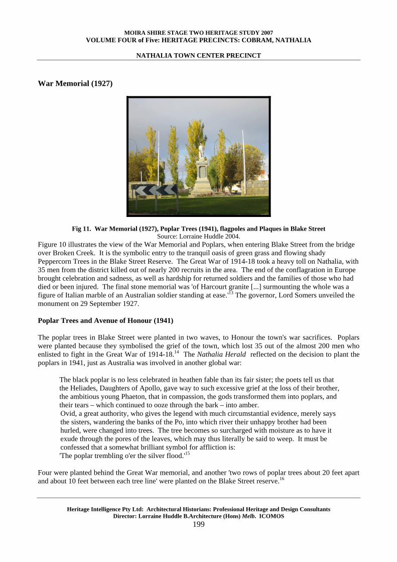
Fig 11. War Memorial (1927), Poplar Trees (1941), flagpoles and Plaques in Blake Street Source: Lorraine Huddle 2004.
Figure 10 illustrates the view of the War Memorial and Poplars, when entering Blake Street from the bridge over Broken Creek. It is the symbolic entry to the tranquil oasis of green grass and flowing shady Peppercorn Trees in the Blake Street Reserve. The Great War of 1914-18 took a heavy toll on Nathalia, with 35 men from the district killed out of nearly 200 recruits in the area. The end of the conflagration in Europe brought celebration and sadness, as well as hardship for returned soldiers and the families of those who had died or been injured. The final stone memorial was 'of Harcourt granite [...] surmounting the whole was a figure of Italian marble of an Australian soldier standing at ease.'13 The governor, Lord Somers unveiled the monument on 29 September 1927. Poplar Trees and Avenue of Honour (1941) The poplar trees in Blake Street were planted in two waves, to Honour the town's war sacrifices. Poplars were planted because they symbolised the grief of the town, which lost 35 out of the almost 200 men who enlisted to fight in the Great War of 1914-18.14 The Nathalia Herald reflected on the decision to plant the poplars in 1941, just as Australia was involved in another global war:
The black poplar is no less celebrated in heathen fable than its fair sister; the poets tell us that the Heliades, Daughters of Apollo, gave way to such excessive grief at the loss of their brother, the ambitious young Phaeton, that in compassion, the gods transformed them into poplars, and their tears – which continued to ooze through the bark – into amber. Ovid, a great authority, who gives the legend with much circumstantial evidence, merely says the sisters, wandering the banks of the Po, into which river their unhappy brother had been hurled, were changed into trees. The tree becomes so surcharged with moisture as to have it exude through the pores of the leaves, which may thus literally be said to weep. It must be confessed that a somewhat brilliant symbol for affliction is: 'The poplar trembling o'er the silver flood.'15
Four were planted behind the Great War memorial, and another 'two rows of poplar trees about 20 feet apart and about 10 feet between each tree line' were planted on the Blake Street reserve.16
MOIRA SHIRE STAGE TWO HERITAGE STUDY 2007 VOLUME FOUR of Five: HERITAGE PRECINCTS: COBRAM, NATHALIA
NATHALIA TOWN CENTER PRECINCT
Heritage Intelligence Pty Ltd: Architectural Historians: Professional Heritage and Design Consultants Director: Lorraine Huddle B.Architecture (Hons) Melb. ICOMOS
200
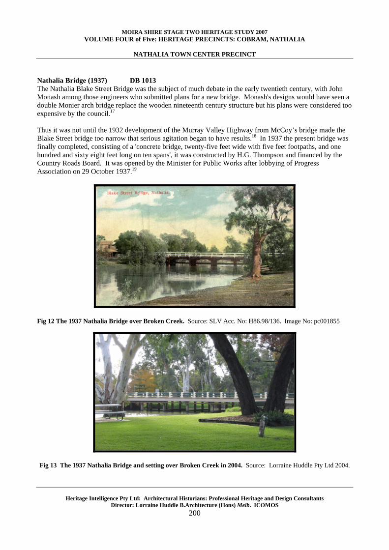
Nathalia Bridge (1937) DB 1013 The Nathalia Blake Street Bridge was the subject of much debate in the early twentieth century, with John Monash among those engineers who submitted plans for a new bridge. Monash's designs would have seen a double Monier arch bridge replace the wooden nineteenth century structure but his plans were considered too expensive by the council.17 Thus it was not until the 1932 development of the Murray Valley Highway from McCoy’s bridge made the Blake Street bridge too narrow that serious agitation began to have results.18 In 1937 the present bridge was finally completed, consisting of a 'concrete bridge, twenty-five feet wide with five feet footpaths, and one hundred and sixty eight feet long on ten spans', it was constructed by H.G. Thompson and financed by the Country Roads Board. It was opened by the Minister for Public Works after lobbying of Progress Association on 29 October 1937.19
Fig 12 The 1937 Nathalia Bridge over Broken Creek. Source: SLV Acc. No: H86.98/136. Image No: pc001855
Fig 13 The 1937 Nathalia Bridge and setting over Broken Creek in 2004. Source: Lorraine Huddle Pty Ltd 2004.
MOIRA SHIRE STAGE TWO HERITAGE STUDY 2007 VOLUME FOUR of Five: HERITAGE PRECINCTS: COBRAM, NATHALIA
NATHALIA TOWN CENTER PRECINCT
Heritage Intelligence Pty Ltd: Architectural Historians: Professional Heritage and Design Consultants Director: Lorraine Huddle B.Architecture (Hons) Melb. ICOMOS
201
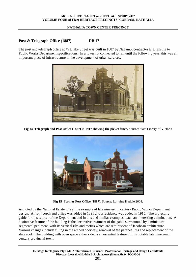
Post & Telegraph Office (1887) DB 17 The post and telegraph office at 49 Blake Street was built in 1887 by Nagambi contractor E. Brensing to Public Works Department specifications. In a town not connected to rail until the following year, this was an important piece of infrastructure in the development of urban services.
Fig 14 Telegraph and Post Office (1887) in 1917 showing the picket fence. Source: State Library of Victoria
Fig 15 Former Post Office (1887), Source: Lorraine Huddle 2004.
As noted by the National Estate it is a fine example of late nineteenth century Public Works Department design. A front porch and office was added in 1891 and a residence was added in 1915. The projecting gable form is typical of the Department and in this and similar examples reach an interesting culmination. A distinctive feature of the building is the decorative treatment of the gable surmounted by a miniature segmental pediment, with its vertical ribs and motifs which are reminiscent of Jacobean architecture. Various changes include filling in the arched doorway, removal of the parapet urns and replacement of the slate roof. The building with open space either side, is an essential feature of this notable late nineteenth century provincial town.
MOIRA SHIRE STAGE TWO HERITAGE STUDY 2007 VOLUME FOUR of Five: HERITAGE PRECINCTS: COBRAM, NATHALIA
NATHALIA TOWN CENTER PRECINCT
Heritage Intelligence Pty Ltd: Architectural Historians: Professional Heritage and Design Consultants Director: Lorraine Huddle B.Architecture (Hons) Melb. ICOMOS
202
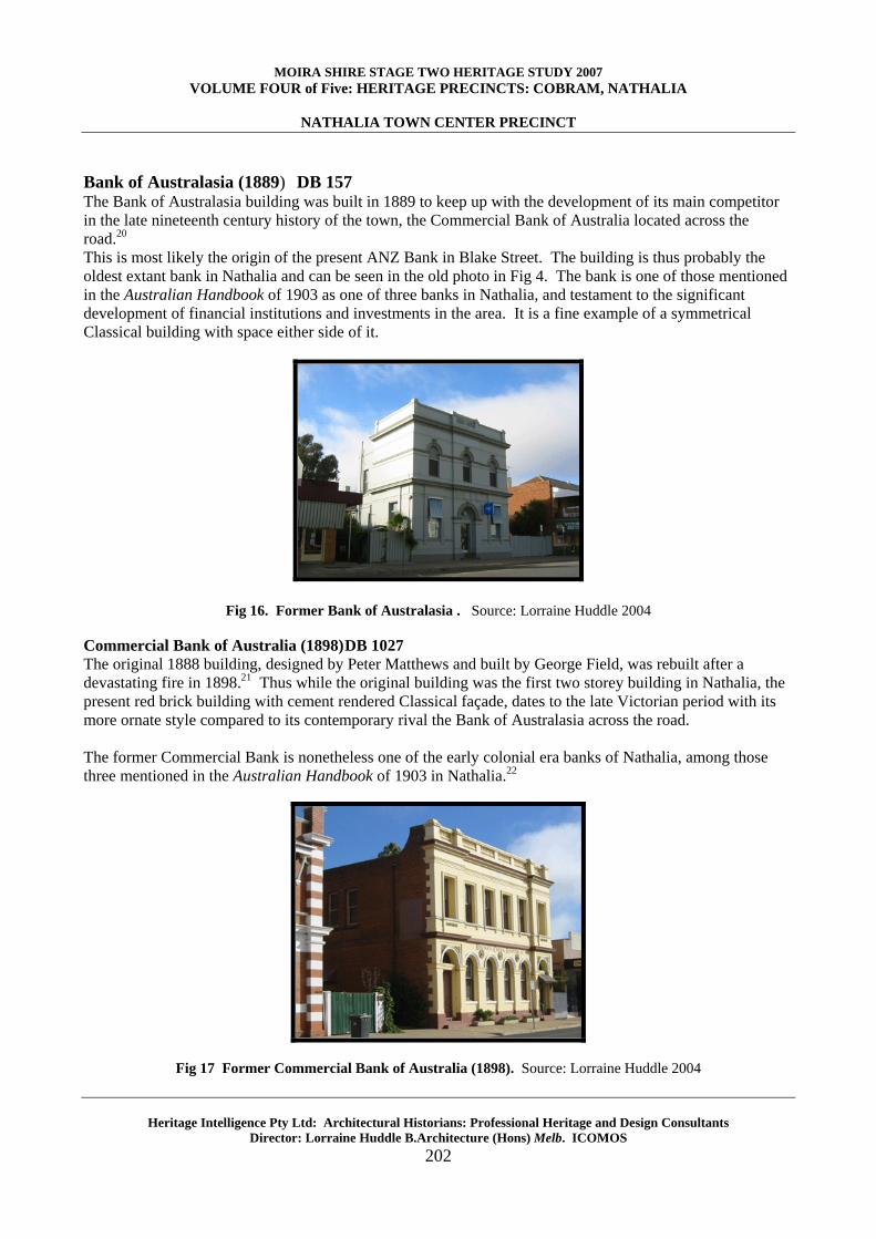
Bank of Australasia (1889) DB 157 The Bank of Australasia building was built in 1889 to keep up with the development of its main competitor in the late nineteenth century history of the town, the Commercial Bank of Australia located across the road.20 This is most likely the origin of the present ANZ Bank in Blake Street. The building is thus probably the oldest extant bank in Nathalia and can be seen in the old photo in Fig 4. The bank is one of those mentioned in the Australian Handbook of 1903 as one of three banks in Nathalia, and testament to the significant development of financial institutions and investments in the area. It is a fine example of a symmetrical Classical building with space either side of it.
Fig 16. Former Bank of Australasia . Source: Lorraine Huddle 2004
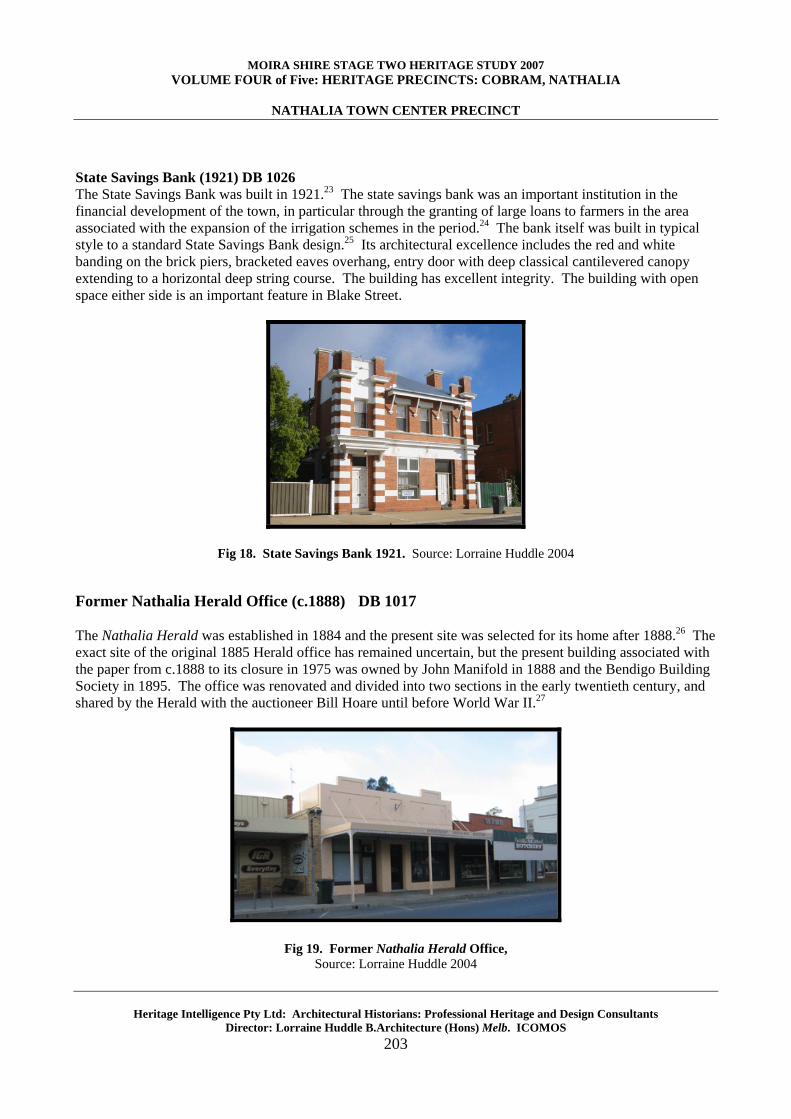
Commercial Bank of Australia (1898) DB 1027 The original 1888 building, designed by Peter Matthews and built by George Field, was rebuilt after a devastating fire in 1898.21 Thus while the original building was the first two storey building in Nathalia, the present red brick building with cement rendered Classical façade, dates to the late Victorian period with its more ornate style compared to its contemporary rival the Bank of Australasia across the road. The former Commercial Bank is nonetheless one of the early colonial era banks of Nathalia, among those three mentioned in the Australian Handbook of 1903 in Nathalia.22
Fig 17 Former Commercial Bank of Australia (1898). Source: Lorraine Huddle 2004
MOIRA SHIRE STAGE TWO HERITAGE STUDY 2007 VOLUME FOUR of Five: HERITAGE PRECINCTS: COBRAM, NATHALIA
NATHALIA TOWN CENTER PRECINCT
Heritage Intelligence Pty Ltd: Architectural Historians: Professional Heritage and Design Consultants Director: Lorraine Huddle B.Architecture (Hons) Melb. ICOMOS
203
State Savings Bank (1921) DB 1026 The State Savings Bank was built in 1921.23 The state savings bank was an important institution in the financial development of the town, in particular through the granting of large loans to farmers in the area associated with the expansion of the irrigation schemes in the period.24 The bank itself was built in typical style to a standard State Savings Bank design.25 Its architectural excellence includes the red and white banding on the brick piers, bracketed eaves overhang, entry door with deep classical cantilevered canopy extending to a horizontal deep string course. The building has excellent integrity. The building with open space either side is an important feature in Blake Street.
Fig 18. State Savings Bank 1921. Source: Lorraine Huddle 2004
Former Nathalia Herald Office (c.1888) DB 1017 The Nathalia Herald was established in 1884 and the present site was selected for its home after 1888.26 The exact site of the original 1885 Herald office has remained uncertain, but the present building associated with the paper from c.1888 to its closure in 1975 was owned by John Manifold in 1888 and the Bendigo Building Society in 1895. The office was renovated and divided into two sections in the early twentieth century, and shared by the Herald with the auctioneer Bill Hoare until before World War II.27
Fig 19. Former Nathalia Herald Office, Source: Lorraine Huddle 2004

MOIRA SHIRE STAGE TWO HERITAGE STUDY 2007 VOLUME FOUR of Five: HERITAGE PRECINCTS: COBRAM, NATHALIA
NATHALIA TOWN CENTER PRECINCT
Heritage Intelligence Pty Ltd: Architectural Historians: Professional Heritage and Design Consultants Director: Lorraine Huddle B.Architecture (Hons) Melb. ICOMOS
204
Nathalia Hotel (1914) DB 1019
Fig 20. Nathalia Hotel: Source: Lorraine Huddle 2004
The first Nathalia Hotel was built by D. Nicholson on the approximate site of the present hotel in 1882, making it the earliest hotel site in Nathalia. The hotel was expanded in 1891.28 The Nathalia Herald reported in April of that year: 'Mr Maguire intends adding a large front to his hotel and we also learn the Nathalia Hotel is to have a large two storey building erected on its present site.'29 It was one of five hotels listed at Nathalia in the 1903 Australian Handbook. In 1914 the hotel was rebuilt in brick with a second storey.30 Throughout this time the hotel retained a social as well as commercial significance in the town's life. During the interwar period a Myer showroom was also opened in the hotel, adding to its commercial history.31 Bridge Hotel (1882, 1905) DB 138 The original Bridge Hotel at 6 Blake Street was built by Richard Blake opposite his mill, on land that formed a part of his selection west of Blake Street in 1882. It was originally called the Temperance Hotel and run by M. J. Oates. The site is thus significant as one associated with a hotel since the early history of the town. It changed name with successive proprietors, becoming the Bridge Temperance Hotel in 1886, Kinsella's Bridge Hotel in 1887 and known as Lightband's Hotel in the early 1900s. It was one of five hotels listed at Nathalia in the 1903 Australian Handbook. The present building took much of its form in 1905 when the Bridge Hotel was expanded by M. Colgan who joined two brick premises and substantially rebuilt the property.32 The second storey was added by Ellen Mary after 1952, following the death of her husband and the previous owner of the hotel Owen Gray, who had taken over the hotel in 1913.33
Fig 21. Bridge Hotel (1905) Source: Lorraine Huddle 2004
MOIRA SHIRE STAGE TWO HERITAGE STUDY 2007 VOLUME FOUR of Five: HERITAGE PRECINCTS: COBRAM, NATHALIA
NATHALIA TOWN CENTER PRECINCT
Heritage Intelligence Pty Ltd: Architectural Historians: Professional Heritage and Design Consultants Director: Lorraine Huddle B.Architecture (Hons) Melb. ICOMOS
205
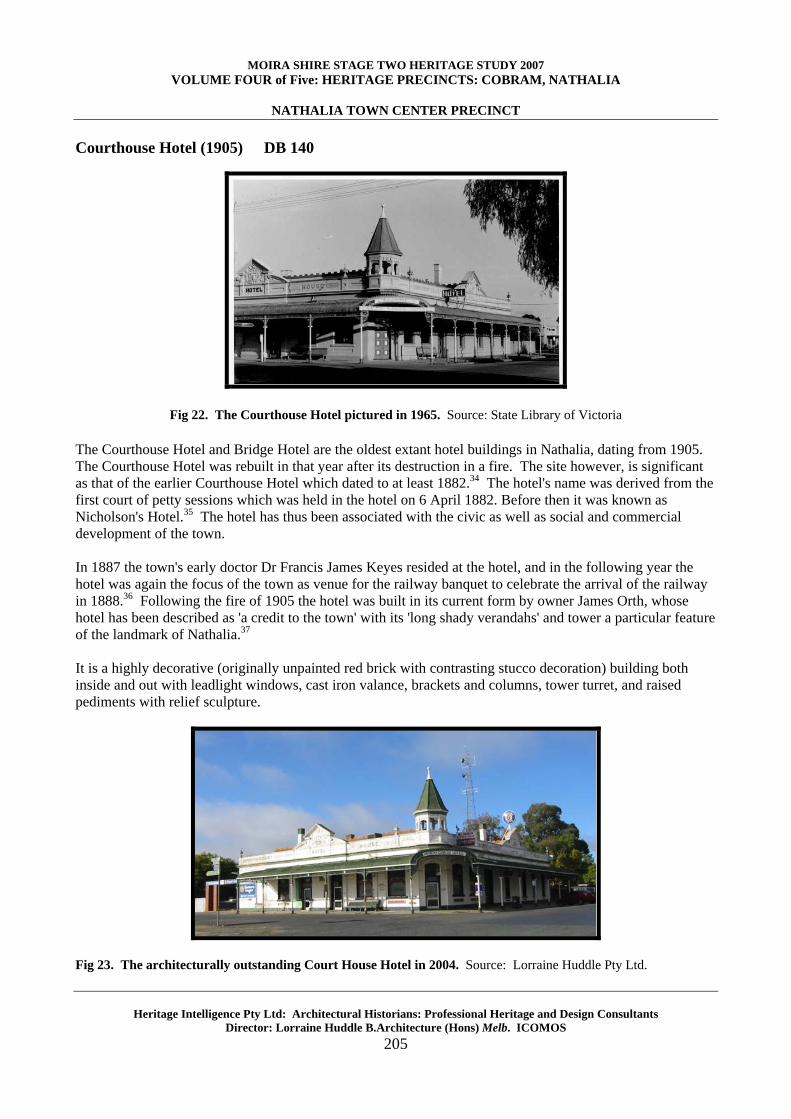
Courthouse Hotel (1905) DB 140
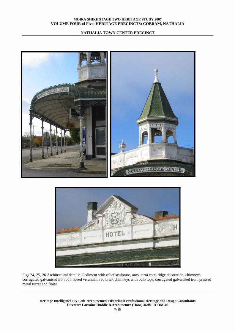
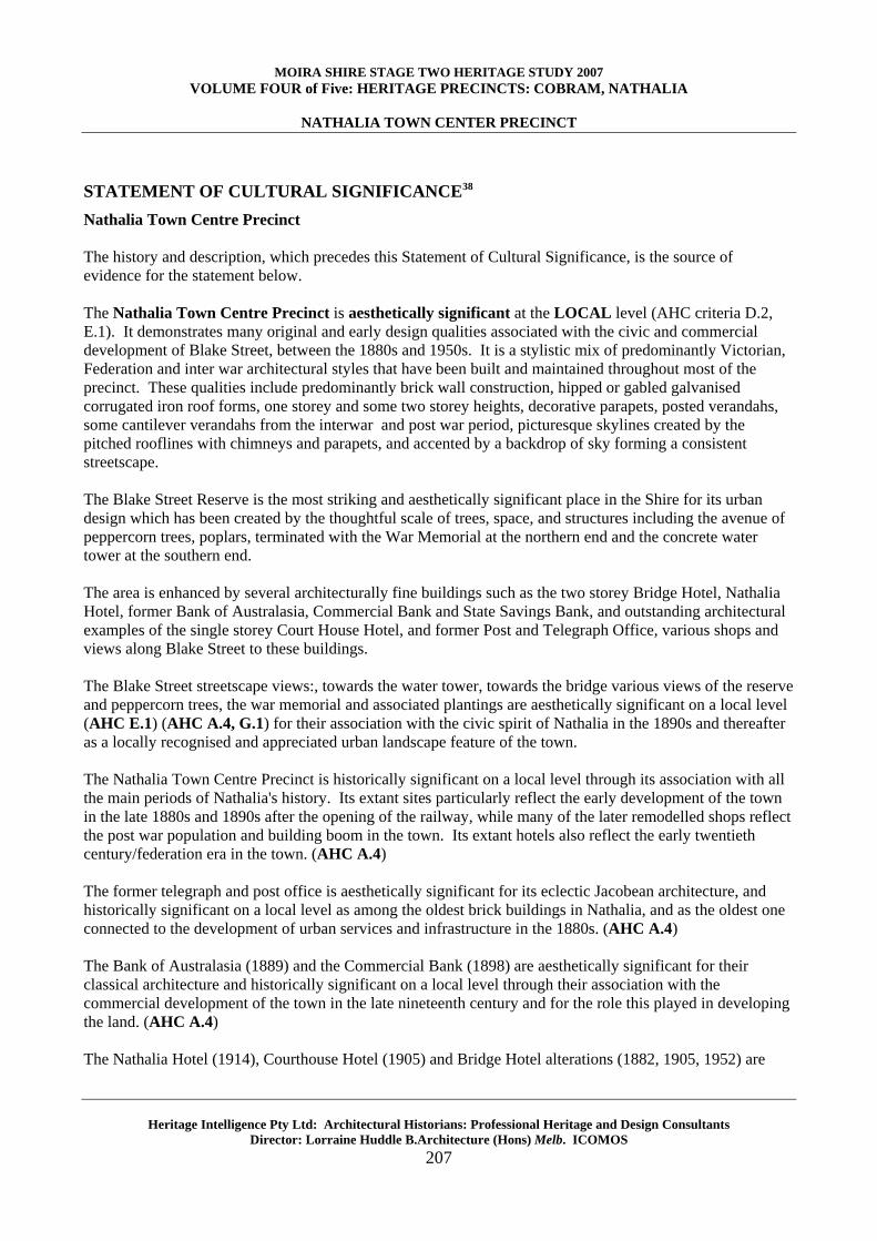
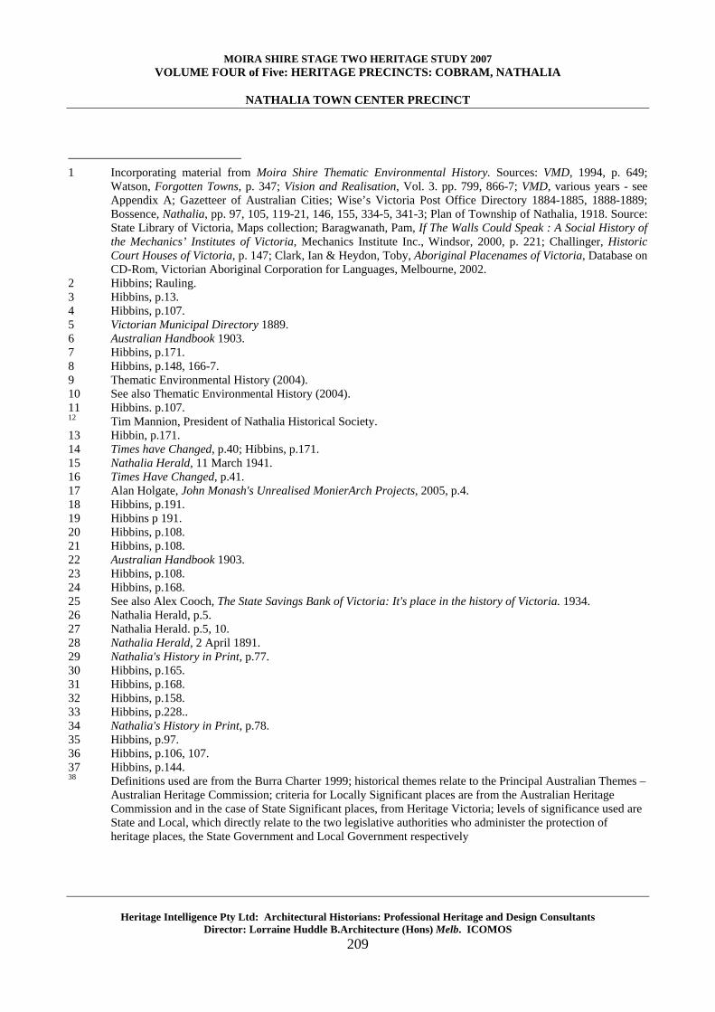
Fig 22. The Courthouse Hotel pictured in 1965. Source: State Library of Victoria The Courthouse Hotel and Bridge Hotel are the oldest extant hotel buildings in Nathalia, dating from 1905. The Courthouse Hotel was rebuilt in that year after its destruction in a fire. The site however, is significant as that of the earlier Courthouse Hotel which dated to at least 1882.34 The hotel's name was derived from the first court of petty sessions which was held in the hotel on 6 April 1882. Before then it was known as Nicholson's Hotel.35 The hotel has thus been associated with the civic as well as social and commercial development of the town. In 1887 the town's early doctor Dr Francis James Keyes resided at the hotel, and in the following year the hotel was again the focus of the town as venue for the railway banquet to celebrate the arrival of the railway in 1888.36 Following the fire of 1905 the hotel was built in its current form by owner James Orth, whose hotel has been described as 'a credit to the town' with its 'long shady verandahs' and tower a particular feature of the landmark of Nathalia.37 It is a highly decorative (originally unpainted red brick with contrasting stucco decoration) building both inside and out with leadlight windows, cast iron valance, brackets and columns, tower turret, and raised pediments with relief sculpture.
Fig 23. The architecturally outstanding Court House Hotel in 2004. Source: Lorraine Huddle Pty Ltd.
MOIRA SHIRE STAGE TWO HERITAGE STUDY 2007 VOLUME FOUR of Five: HERITAGE PRECINCTS: COBRAM, NATHALIA
NATHALIA TOWN CENTER PRECINCT
Heritage Intelligence Pty Ltd: Architectural Historians: Professional Heritage and Design Consultants Director: Lorraine Huddle B.Architecture (Hons) Melb. ICOMOS
206
Figs 24, 25, 26 Architectural details: Pediment with relief sculpture, urns, terra cotta ridge decoration, chimneys, corrugated galvanised iron bull nosed verandah, red brick chimneys with bulb tops, corrugated galvanised iron, pressed metal turret and finial.
MOIRA SHIRE STAGE TWO HERITAGE STUDY 2007 VOLUME FOUR of Five: HERITAGE PRECINCTS: COBRAM, NATHALIA
NATHALIA TOWN CENTER PRECINCT
Heritage Intelligence Pty Ltd: Architectural Historians: Professional Heritage and Design Consultants Director: Lorraine Huddle B.Architecture (Hons) Melb. ICOMOS
207
STATEMENT OF CULTURAL SIGNIFICANCE38
Nathalia Town Centre Precinct The history and description, which precedes this Statement of Cultural Significance, is the source of evidence for the statement below. The Nathalia Town Centre Precinct is aesthetically significant at the LOCAL level (AHC criteria D.2, E.1). It demonstrates many original and early design qualities associated with the civic and commercial development of Blake Street, between the 1880s and 1950s. It is a stylistic mix of predominantly Victorian, Federation and inter war architectural styles that have been built and maintained throughout most of the precinct. These qualities include predominantly brick wall construction, hipped or gabled galvanised corrugated iron roof forms, one storey and some two storey heights, decorative parapets, posted verandahs, some cantilever verandahs from the interwar and post war period, picturesque skylines created by the pitched rooflines with chimneys and parapets, and accented by a backdrop of sky forming a consistent streetscape. The Blake Street Reserve is the most striking and aesthetically significant place in the Shire for its urban design which has been created by the thoughtful scale of trees, space, and structures including the avenue of peppercorn trees, poplars, terminated with the War Memorial at the northern end and the concrete water tower at the southern end. The area is enhanced by several architecturally fine buildings such as the two storey Bridge Hotel, Nathalia Hotel, former Bank of Australasia, Commercial Bank and State Savings Bank, and outstanding architectural examples of the single storey Court House Hotel, and former Post and Telegraph Office, various shops and views along Blake Street to these buildings. The Blake Street streetscape views:, towards the water tower, towards the bridge various views of the reserve and peppercorn trees, the war memorial and associated plantings are aesthetically significant on a local level (AHC E.1) (AHC A.4, G.1) for their association with the civic spirit of Nathalia in the 1890s and thereafter as a locally recognised and appreciated urban landscape feature of the town. The Nathalia Town Centre Precinct is historically significant on a local level through its association with all the main periods of Nathalia's history. Its extant sites particularly reflect the early development of the town in the late 1880s and 1890s after the opening of the railway, while many of the later remodelled shops reflect the post war population and building boom in the town. Its extant hotels also reflect the early twentieth century/federation era in the town. (AHC A.4) The former telegraph and post office is aesthetically significant for its eclectic Jacobean architecture, and historically significant on a local level as among the oldest brick buildings in Nathalia, and as the oldest one connected to the development of urban services and infrastructure in the 1880s. (AHC A.4) The Bank of Australasia (1889) and the Commercial Bank (1898) are aesthetically significant for their classical architecture and historically significant on a local level through their association with the commercial development of the town in the late nineteenth century and for the role this played in developing the land. (AHC A.4) The Nathalia Hotel (1914), Courthouse Hotel (1905) and Bridge Hotel alterations (1882, 1905, 1952) are

MOIRA SHIRE STAGE TWO HERITAGE STUDY 2007 VOLUME FOUR of Five: HERITAGE PRECINCTS: COBRAM, NATHALIA
NATHALIA TOWN CENTER PRECINCT
Heritage Intelligence Pty Ltd: Architectural Historians: Professional Heritage and Design Consultants Director: Lorraine Huddle B.Architecture (Hons) Melb. ICOMOS
208
historically significant on a local level as continuous sites of hotels in the town dating to the late nineteenth century and as sites of social, recreational and cultural activity in Nathalia since that period. The Bridge Hotel was first established in 1882 and may have some remnants dating from that time until the main alterations in 1905 and 1952. (AHC A.4) The Courthouse Hotel (1905) is architecturally significant for its highly intact Federation style architectural form and decorative details and also historically significant on a local level for its civic associations as the site of the first court and socially significant on a local level as a recognised heritage site interwoven with the history of Nathalia. (AHC G.1, H.1) Unlike the Bridge Hotel which was modified in 1952, the Courthouse Hotel has also retained its original form and as such is the oldest preserved hotel in Nathalia. The War Memorial (1927) and poplars are aesthetically, historically and socially important on a local level through its association with the history of defending Australia, particularly in the Great War of 1914-18, and as a recognised site of local memory and the great losses and sacrifices of the town in war. The site has been associated with both the first and subsequently the Second World War. (AHC A.4, G.1) The Nathalia Bridge (1937) is historically and aesthetically significant on a local level as an example of interwar transport infrastructure in the town. (AHC A.4) The Nathalia Town Centre Precinct is scientifically significant on a LOCAL level (Criteria C2, F1). Building materials such wrought iron, cast iron, terra cotta roof decoration, marble and granite, and stained glass re testament to the high level of technical skill that artisans in Nathalia possessed. The use of these materials is becoming rare and their presence forms an integral part of the precinct’s fabric. The interwar concrete bridge and water tower are excellent examples of infrastructure design of their era.
Overall, the Nathalia Town Centre Precinct is culturally significant at the LOCAL level.
MOIRA SHIRE STAGE TWO HERITAGE STUDY 2007 VOLUME FOUR of Five: HERITAGE PRECINCTS: COBRAM, NATHALIA
NATHALIA TOWN CENTER PRECINCT
Heritage Intelligence Pty Ltd: Architectural Historians: Professional Heritage and Design Consultants Director: Lorraine Huddle B.Architecture (Hons) Melb. ICOMOS
209
1 Incorporating material from Moira Shire Thematic Environmental History. Sources: VMD, 1994, p. 649;
Watson, Forgotten Towns, p. 347; Vision and Realisation, Vol. 3. pp. 799, 866-7; VMD, various years - see Appendix A; Gazetteer of Australian Cities; Wise’s Victoria Post Office Directory 1884-1885, 1888-1889; Bossence, Nathalia, pp. 97, 105, 119-21, 146, 155, 334-5, 341-3; Plan of Township of Nathalia, 1918. Source: State Library of Victoria, Maps collection; Baragwanath, Pam, If The Walls Could Speak : A Social History of the Mechanics’ Institutes of Victoria, Mechanics Institute Inc., Windsor, 2000, p. 221; Challinger, Historic Court Houses of Victoria, p. 147; Clark, Ian & Heydon, Toby, Aboriginal Placenames of Victoria, Database on CD-Rom, Victorian Aboriginal Corporation for Languages, Melbourne, 2002.
2 Hibbins; Rauling. 3 Hibbins, p.13. 4 Hibbins, p.107. 5 Victorian Municipal Directory 1889. 6 Australian Handbook 1903. 7 Hibbins, p.171. 8 Hibbins, p.148, 166-7. 9 Thematic Environmental History (2004). 10 See also Thematic Environmental History (2004). 11 Hibbins. p.107. 12 Tim Mannion, President of Nathalia Historical Society. 13 Hibbin, p.171. 14 Times have Changed, p.40; Hibbins, p.171. 15 Nathalia Herald, 11 March 1941. 16 Times Have Changed, p.41. 17 Alan Holgate, John Monash's Unrealised MonierArch Projects, 2005, p.4. 18 Hibbins, p.191. 19 Hibbins p 191. 20 Hibbins, p.108. 21 Hibbins, p.108. 22 Australian Handbook 1903. 23 Hibbins, p.108. 24 Hibbins, p.168. 25 See also Alex Cooch, The State Savings Bank of Victoria: It's place in the history of Victoria. 1934. 26 Nathalia Herald, p.5. 27 Nathalia Herald. p.5, 10. 28 Nathalia Herald, 2 April 1891. 29 Nathalia's History in Print, p.77. 30 Hibbins, p.165. 31 Hibbins, p.168. 32 Hibbins, p.158. 33 Hibbins, p.228.. 34 Nathalia's History in Print, p.78. 35 Hibbins, p.97. 36 Hibbins, p.106, 107. 37 Hibbins, p.144. 38 Definitions used are from the Burra Charter 1999; historical themes relate to the Principal Australian Themes –
Australian Heritage Commission; criteria for Locally Significant places are from the Australian Heritage Commission and in the case of State Significant places, from Heritage Victoria; levels of significance used are State and Local, which directly relate to the two legislative authorities who administer the protection of heritage places, the State Government and Local Government respectively