Unit 2: Human Geography Review Unit 2: Human Geography Review.
Module 1.1: What is Human Geography? (ch. 1) Test A AP Human Geography Mr. Rackley
1. Poverty, the failure of equal food distribution, and the cultural practice of men being favored
over women and children are all causes of?
a. Homelessness
b. Wage Slavery
c. Malnourishment
d. Impotency
e. Communism
2. What type of biome falls between the poles and both arctic circles, its name means “treeless
mountain tract?”
a. Forests
b. Deserts
c. Grasslands
d. Wetlands
e. Tundra Regions
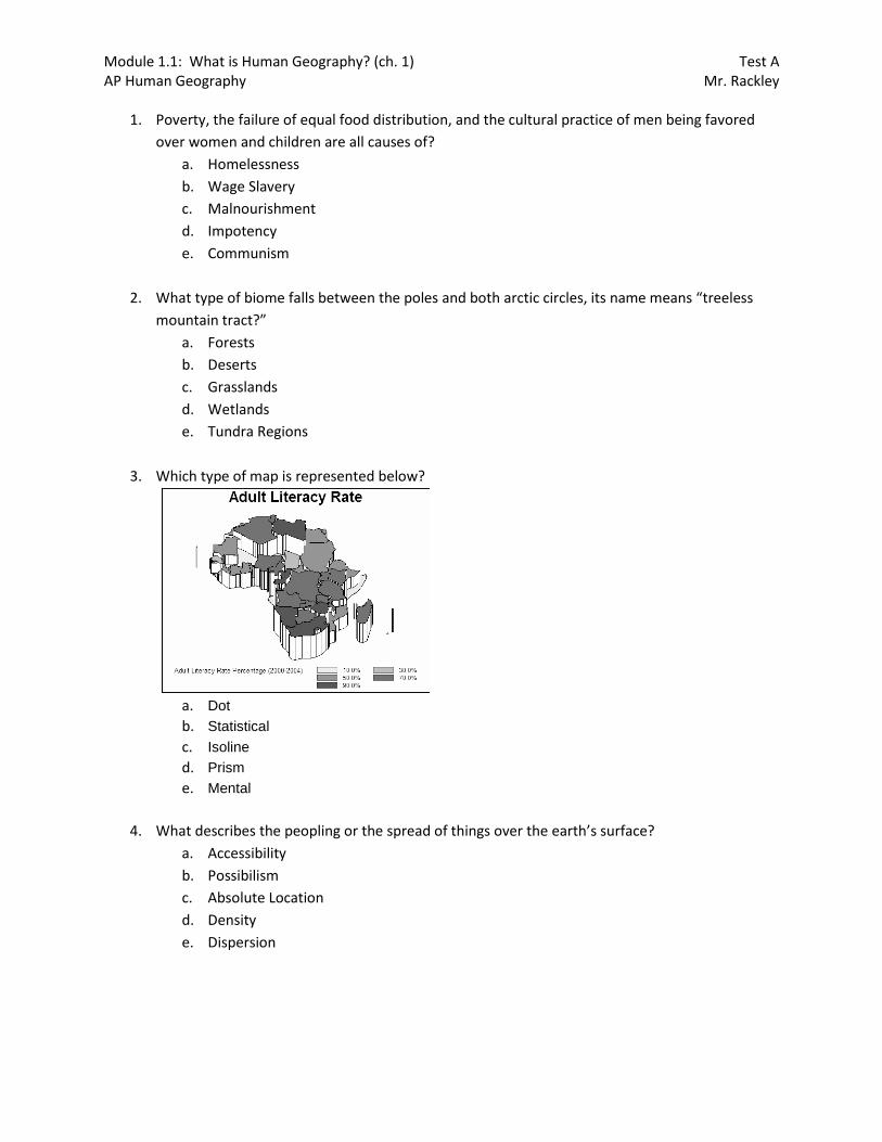
3. Which type of map is represented below?
a. Dot
b. Statistical
c. Isoline
d. Prism
e. Mental
4. What describes the peopling or the spread of things over the earth’s surface?
a. Accessibility
b. Possibilism
c. Absolute Location
d. Density
e. Dispersion

Module 1.1: What is Human Geography? (ch. 1) Test A AP Human Geography Mr. Rackley
5. In examining a country’s type of territorial morphology, what type of region is extremely hard to
conquer, but it is also extremely hard to control?
a. Compact
b. Elongated
c. Prorupt
d. Fragmented
e. Perforated
6. Using the diagram below, analyze the colored area’s morphology and determine what type of
region it is?
a. Compact
b. Elongated
c. Prorupt
d. Fragmented
e. Perforated
7. In the ancient period of human history, what was it called when natural surroundings influenced
human decision?
a. Dispersion
b. Accessibility
c. Possibilism
d. Environmental Determinism
e. Spatial Distribution

Module 1.1: What is Human Geography? (ch. 1) Test A AP Human Geography Mr. Rackley
8. The map below shows the world’s number of deaths, based on wars and combat. What type of
map is this?
a. Cartogram
b. Prism
c. Isotherm
d. Dot
e. Statistical
9. The marshlands of the Everglades would be defined as what type of region?
a. Possible
b. Formal
c. Perceptual
d. Functional
e. Absolute
10. What type of biome occurs at the Arctic Circle, the Antarctic Circle, and the equator, and
receives on average over thirty inches of rain?
a. Forests
b. Deserts
c. Grasslands
d. Wetlands
e. Tundra Regions
Module 1.1: What is Human Geography? (ch. 1) Test A AP Human Geography Mr. Rackley
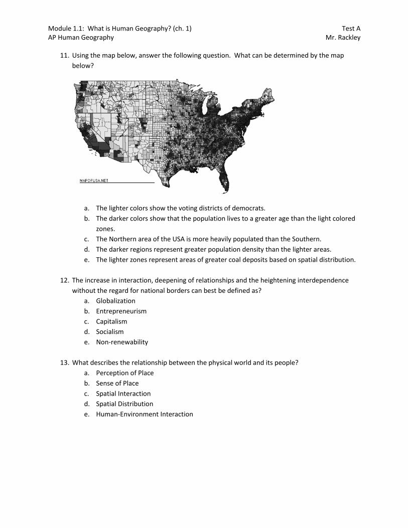
11. Using the map below, answer the following question. What can be determined by the map
below?
a. The lighter colors show the voting districts of democrats.
b. The darker colors show that the population lives to a greater age than the light colored
zones.
c. The Northern area of the USA is more heavily populated than the Southern.
d. The darker regions represent greater population density than the lighter areas.
e. The lighter zones represent areas of greater coal deposits based on spatial distribution.
12. The increase in interaction, deepening of relationships and the heightening interdependence
without the regard for national borders can best be defined as?
a. Globalization
b. Entrepreneurism
c. Capitalism
d. Socialism
e. Non-renewability
13. What describes the relationship between the physical world and its people?
a. Perception of Place
b. Sense of Place
c. Spatial Interaction
d. Spatial Distribution
e. Human-Environment Interaction
Module 1.1: What is Human Geography? (ch. 1) Test A AP Human Geography Mr. Rackley
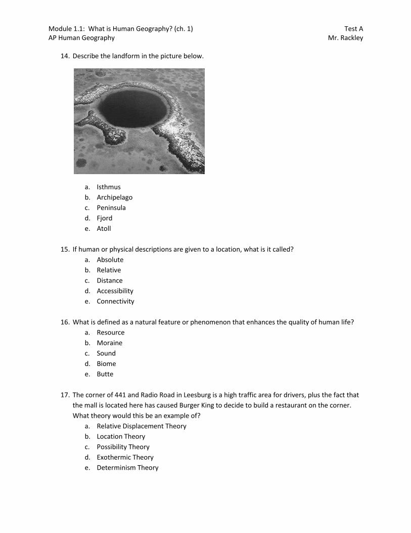
14. Describe the landform in the picture below.
a. Isthmus
b. Archipelago
c. Peninsula
d. Fjord
e. Atoll
15. If human or physical descriptions are given to a location, what is it called?
a. Absolute
b. Relative
c. Distance
d. Accessibility
e. Connectivity
16. What is defined as a natural feature or phenomenon that enhances the quality of human life?
a. Resource
b. Moraine
c. Sound
d. Biome
e. Butte
17. The corner of 441 and Radio Road in Leesburg is a high traffic area for drivers, plus the fact that
the mall is located here has caused Burger King to decide to build a restaurant on the corner.
What theory would this be an example of?
a. Relative Displacement Theory
b. Location Theory
c. Possibility Theory
d. Exothermic Theory
e. Determinism Theory
Module 1.1: What is Human Geography? (ch. 1) Test A AP Human Geography Mr. Rackley
18. In examining a country’s type of territorial morphology, what type of region is commonly subject
to binodalism?
a. Compact
b. Elongated
c. Prorupt
d. Fragmented
e. Perforated
19. Since Hindus are vegetarian, the introduction of a McDonalds to India would most likely
encounter?
a. Cultural Barriers
b. Cultural Hearth
c. Formal Region
d. Rescaling
e. Remote Sensing
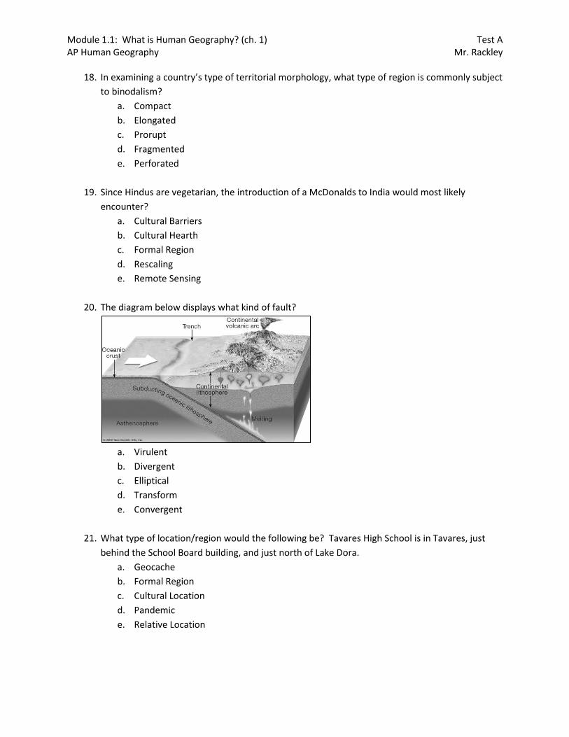
20. The diagram below displays what kind of fault?
a. Virulent
b. Divergent
c. Elliptical
d. Transform
e. Convergent
21. What type of location/region would the following be? Tavares High School is in Tavares, just
behind the School Board building, and just north of Lake Dora.
a. Geocache
b. Formal Region
c. Cultural Location
d. Pandemic
e. Relative Location
Module 1.1: What is Human Geography? (ch. 1) Test A AP Human Geography Mr. Rackley
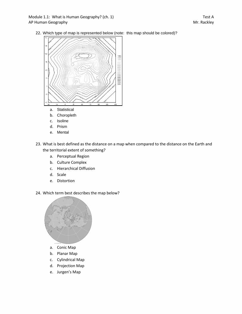
22. Which type of map is represented below (note: this map should be colored)?
a. Statistical
b. Choropleth
c. Isoline
d. Prism
e. Mental
23. What is best defined as the distance on a map when compared to the distance on the Earth and
the territorial extent of something?
a. Perceptual Region
b. Culture Complex
c. Hierarchical Diffusion
d. Scale
e. Distortion
24. Which term best describes the map below?
a. Conic Map
b. Planar Map
c. Cylindrical Map
d. Projection Map
e. Jurgen’s Map

Module 1.1: What is Human Geography? (ch. 1) Test A AP Human Geography Mr. Rackley
25. What type of map is represented below?
a. Cartogram
b. Prism
c. Isoline
d. Dot
e. Statistical
26. Describe the landform in the picture below.
a. Isthmus
b. Archipelago
c. Peninsula
d. Fjord
e. Atoll
Module 1.1: What is Human Geography? (ch. 1) Test A AP Human Geography Mr. Rackley
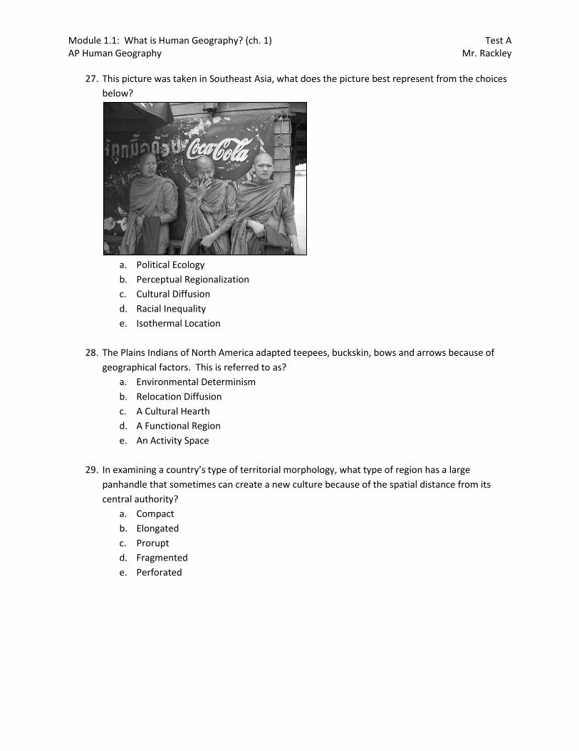
27. This picture was taken in Southeast Asia, what does the picture best represent from the choices
below?
a. Political Ecology
b. Perceptual Regionalization
c. Cultural Diffusion
d. Racial Inequality
e. Isothermal Location
28. The Plains Indians of North America adapted teepees, buckskin, bows and arrows because of
geographical factors. This is referred to as?
a. Environmental Determinism
b. Relocation Diffusion
c. A Cultural Hearth
d. A Functional Region
e. An Activity Space
29. In examining a country’s type of territorial morphology, what type of region has a large
panhandle that sometimes can create a new culture because of the spatial distance from its
central authority?
a. Compact
b. Elongated
c. Prorupt
d. Fragmented
e. Perforated
Module 1.1: What is Human Geography? (ch. 1) Test A AP Human Geography Mr. Rackley
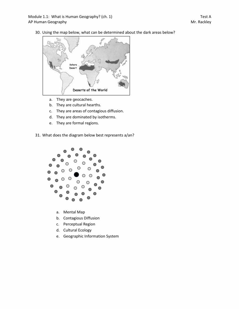
30. Using the map below, what can be determined about the dark areas below?
a. They are geocaches.
b. They are cultural hearths.
c. They are areas of contagious diffusion.
d. They are dominated by isotherms.
e. They are formal regions.
31. What does the diagram below best represents a/an?
a. Mental Map
b. Contagious Diffusion
c. Perceptual Region
d. Cultural Ecology
e. Geographic Information System

Module 1.1: What is Human Geography? (ch. 1) Test A AP Human Geography Mr. Rackley
32. Which of the following is not true about the map below?
a. This map shows meridians.
b. The lines on this map measure north & south degrees.
c. This map shows lines of longitude.
d. The lines on this map run north & south.
e. The Greenwich Line is a zero degree.
33. What is critical in understanding the maps below?
a. Geometric Positioning
b. Fundamental Location
c. Scale
d. Distortion
e. Culture
34. Wheat, lumber, stone crab claws are all examples of?
a. Finite Goods
b. Moraines
c. Renewable Resources
d. Non-renewable Resources
e. Biomes
35. A subway system or the highway system would be what type of region?
a. Possible
b. Formal
c. Perceptual
d. Functional
e. Absolute

Module 1.1: What is Human Geography? (ch. 1) Test A AP Human Geography Mr. Rackley
36. Which of the following is not true about the map below?
a. The lines below are lines on longitude.
b. The equator is at zero degrees.
c. The lines run east & west.
d. The lines measure north & south.
e. The lines are parallels.
37. Which of the following is true when comparing the two maps below?
a. The top map is superior to the bottom map because it minimizes distortion.
b. The bottom map is inferior to the top map because it maximizes distortion.
c. Both maps are equal in their usefulness.
d. The top map minimizes distortion less than the bottom map.
e. The bottom map minimizes distortion less than the top map.

Module 1.1: What is Human Geography? (ch. 1) Test A AP Human Geography Mr. Rackley
38. Though maps themselves vary, all of them contain at least one?
a. Variation
b. Theme
c. Line of longitude
d. Line of latitude
e. Equator
39. What type of map is represented below?
a. Cartogram
b. Choropleth
c. Isoline
d. Dot
e. Statistical
40. When combined, what do meridians and parallels make up?
a. Latitude and Longitude
b. Geocaching
c. Grid Lines
d. Projections
e. Miles and Kilometers