MODIS Retrievals for the Amazon Rainforest Dan Sauceda.
22
MODIS Retrievals for the Amazon Rainforest Dan Sauceda
-
Upload
harold-elliott -
Category
Documents
-
view
218 -
download
0
Transcript of MODIS Retrievals for the Amazon Rainforest Dan Sauceda.

MODIS Retrievals for the Amazon RainforestDan Sauceda

Outline
• Information on the Region• Data Information• Reflectance Equations• MODIS Images• NDVI• Conclusions

Information on the Region
• Latitude: 0˚N, -12˚SLongitude: -56˚E, -72˚W• Encompasses 5,500,000 • Countries: Brazil, Peru,
Colombia, Venezuela, Ecuador, Bolivia, Guyana, Suriname, French Guyana

Information on the Region

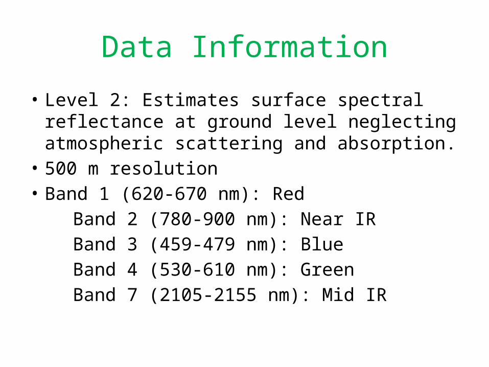
Data Information
• Dry season (July-August)• Satellite: Terra MODIS• Daytime coverage• Selected clear days:– July 27, 2000 (15:15 UTC)– August 6, 2005 (14:30 UTC)– August 2, 2012 (14:25 UTC)
Data Information
• Level 2: Estimates surface spectral reflectance at ground level neglecting atmospheric scattering and absorption.
• 500 m resolution• Band 1 (620-670 nm): Red Band 2 (780-900 nm): Near IR Band 3 (459-479 nm): Blue Band 4 (530-610 nm): Green Band 7 (2105-2155 nm): Mid IR

Reflectance Equations
• is the surface reflectance• The reflectance equations represent an
average relationship.• The equations are best represented for clear
skies.

July 27, 2000 (15:15 UTC)

July 27, 2000 (15:15 UTC)
Clouds/Aerosols
Clouds/Aerosols
𝜌 470=𝜌 2.134
𝜌648=𝜌2.132

July 27, 2000 (15:15 UTC)
Band 1 Band 3
Band 4 Band 7

August 6, 2005 (14:30 UTC)

August 6, 2005 (14:30 UTC)
Aerosols
Aerosols
𝜌 470=𝜌 2.134
𝜌648=𝜌2.132

August 6, 2005 (14:30 UTC)
Band 1 Band 3
Band 4 Band 7

August 2, 2012 (14:25 UTC)

August 2, 2012 (14:25 UTC)
𝜌 470=𝜌 2.134
𝜌648=𝜌2.132
Clouds/Aerosols
Clouds/Aerosols

August 2, 2012 (14:25 UTC)
Band 1 Band 3
Band 4 Band 7

NDVI
• NDVI: Normalized Difference Vegetation Index• An index to help determine live green
vegetation.• Chlorophyll in plants absorbs visible light, and
cell structure of leaves reflect near IR light.• The more leaves on a plant, the more effect
on the wavelengths. • NDVI = (Band 2 – Band 1)/(Band 2 + Band 1)

NDVI
July 27, 2000 (15:15 UTC) August 6, 2005 (14:30 UTC) August 2, 2012 (14:25 UTC)

Conclusions
• Angles of the pictures can skew the image and data.
• Clouds/Aerosols in the area can throw off reflective values.
• Different species of trees may be responsible for some of the slight variability of reflectance values.
• Health of the vegetation can play a part in reflection.

Conclusions
• Slash and burning and wildfires during the dry season may be responsible in skewing land surface reflectance.
• Farm and logging areas showed less reflectance.
• Solar zenith angle may have an effect on the accuracy of surface reflection.

References
• Kaufman, Y.J., Wald, A.E., Lorraine, A.R., Gao, B., Li, R., and L. Flynn, 1997: The MODIS 2.1-μm channel-correlation with visible reflectance for use in remote sensing of aerosol. IEEE Trans. Geosci. Remote Sensing., 35, 1286-1298.
• Remer, L.A., Kaufman, Y.J., Tanre, Mattoo, S., Chu, D.A., Martins, J.V., Li, R.R., Ichoku, C., Levy, R.C., Kleidman, R.G., Eck, T.F., Vermote, E., and B.N. Holben, 2005: The MODIS aerosol algorithm, products, and validation. Amer. Meteor. Soc., 62, 947-973.

Questions