Modernizing Road Construction Plans and · PDF fileThis project captured best practices for...
61
Yelda Turkan, Principal Investigator Construction Management and Technology Program Institute for Transportation Iowa State University September 2016 Research Project Final Report 2016-29 Modernizing Road Construction Plans and Documentation
Transcript of Modernizing Road Construction Plans and · PDF fileThis project captured best practices for...
Yelda Turkan, Principal InvestigatorConstruction Management and Technology Program
Institute for TransportationIowa State University
September 2016
Research ProjectFinal Report 2016-29
Modernizing Road Construction Plans and
Documentation

To request this document in an alternative format call 651-366-4718 or 1-800-657-3774 (Greater Minnesota) or email your request to [email protected]. Please request at least one week in advance.
Technical Report Documentation Page 1. Report No. 2. 3. Recipients Accession No.
MN/RC 2016-294. Title and Subtitle 5. Report Date
Modernizing Road Construction Plans and Documentation September 20166.
7. Author(s) 8. Performing Organization Report No.
Yelda Turkan and Jennifer S. Shane10. Project/Task/Work Unit No. 9. Performing Organization Name and Address
Construction Management and Technology Program Institute for Transportation Iowa State University 2711 S. Loop Drive, Suite 4700 Ames, Iowa 50011-8664
11. Contract (C) or Grant (G) No.
(C) 99004 (wo) 11
12. Sponsoring Organization Name and Address 13. Type of Report and Period Covered
Local Road Research Board Minnesota Department of Transportation Research Services & Library 395 John Ireland Boulevard, MS 330 St. Paul, Minnesota 55155-1899
Final Report14. Sponsoring Agency Code
15. Supplementary Notes
http://www.mndot.gov/research/reports/2016/201629.pdf16. Abstract (Limit: 250 words)
This project captured best practices for producing and delivering road construction plans and documentation from several Minnesota cities and counties, industry, and several other state departments of transportation (DOTs). The findings will assist Minnesota city and county engineers in getting a better understanding of how and which types of plans, models, and other bid documents are used and delivered electronically in the construction industry, and how best practices can be employed in Minnesota cities and counties.
The project included an extensive literature review, phone interviews with experts, and a brainstorming session with super-users. The brainstorming session was held to help assess the recommendations reached through the study and determine how electronic plans, models, and other bid documents are viewed by the implementers in Minnesota cities and counties.
Based on the results of this work, guidance was developed for the implementation of 3D modeling and electronic document management (EDM) systems for the MnDOT Local Road Research Board (LRRB). 17. Document Analysis/Descriptors 18. Availability Statement
mathematical models, data management, documents, bids, road construction
No restrictions. Document available from: National Technical Information Services, Alexandria, Virginia 22312
19. Security Class (this report) 20. Security Class (this page) 21. No. of Pages 22. Price
Unclassified Unclassified 61
Modernizing Road Construction Plans and Documentation
Final Report
Prepared by: Yelda Turkan
Jennifer S. Shane Construction Management and Technology Program
Institute for Transportation Iowa State University
September 2016
Published by: Minnesota Department of Transportation
Research Services & Library 395 John Ireland Boulevard, MS 330
St. Paul, Minnesota 55155-1899
This report represents the results of research conducted by the authors and does not necessarily represent the views or policies of the Minnesota Department of Transportation or Iowa State University. This report does not contain a standard or specified technique.
The authors and the Minnesota Department of Transportation and Iowa State University do not endorse products or manufacturers. Any trade or manufacturers’ names that may appear herein do so solely because they are considered essential to this report.

Acknowledgments
The authors want to thank the Minnesota Department of Transportation and the Minnesota Local Road Research Board for funding this work. They would also like to thank the technical advisory panel (TAP) members and the brainstorming session super-users for their participation, contributions, and insights. Finally, the authors want to thank the National Cooperative Highway Research Program (NCHRP) Domestic Scan 13-02, Advances in Civil Integrated Management (CIM), team members for their work that also resulted in contributions to this project.
Table of Contents
CHAPTER 1: INTRODUCTION .................................................................................................1 1.1 Background and Problem Statement ..............................................................................1 1.2 Research Methodology and Organization of this Report ...............................................4
CHAPTER 2: TASK 1 - BEST PRACTICES WITHIN MINNESOTA CITIES AND COUNTIES .........................................................................................................................6 2.1 3D Modeling Practices ...................................................................................................6 2.2 Bidding Documents and Digital Signatures ...................................................................7 2.3 Document Management and Data Storage ....................................................................8 2.4 Summary of Interview Results.......................................................................................8
CHAPTER 3: TASK 2 - BEST PRACTICES IN EUROPEAN COUNTRIES .....................10 3.1 Visualization ................................................................................................................10 3.2 Simulation from the Models ........................................................................................10 3.3 Lessons Learned/Keys for Successful Implementation ...............................................11
CHAPTER 4: TASK 3 - BEST PRACTICES IN OTHER AGENCIES AND IN INDUSTRY .......................................................................................................................12 4.1 Surveying .....................................................................................................................12 4.2 3D Modeling ................................................................................................................12 4.3 Automatic Machine Guidance .....................................................................................14 4.4 Electronic Document Management Systems ...............................................................14 4.5 Electronic Signatures ...................................................................................................15 4.6 Data Storage and Management ....................................................................................15
CHAPTER 5: TASK 4 - BRAINSTORMING SESSION WITH SUPER-USERS ................16 5.1 SWOT Analysis ...........................................................................................................16 5.2 Barriers and Challenges to Digital Project Delivery....................................................21 5.3 Key Findings ................................................................................................................22
CHAPTER 6: TASK 5 - GUIDELINES ....................................................................................23 6.1 Key Findings ................................................................................................................23 6.2 Fundamental Concepts .................................................................................................23 6.3 Recommended Procedures for Successful Implementation .........................................23
CHAPTER 7: CONCLUSIONS .................................................................................................30 CHAPTER 8: LIMITATIONS AND FUTURE WORK ..........................................................31 REFERENCES .............................................................................................................................32 APPENDIX A. INTERVIEW QUESTIONNAIRE APPENDIX B. SUPER-USERS’ BRAINSTORMING SESSION PRESENTATION APPENDIX C. SUPER-USERS’ BRAINSTORMING SESSION MINUTES
List of Figures
Figure 1. Facility lifecycle with data pool .......................................................................................1 Figure 2. CIM practices and tools ....................................................................................................3 Figure 3. 3D modeling implementation flow .................................................................................26 Figure 4. EDM system implementation flow .................................................................................29
List of Tables
Table 1. 3D modeling SWOT analysis summary ..........................................................................17 Table 2. EDM system SWOT analysis summary ..........................................................................20 Table 3. Platform differences .........................................................................................................27
Executive Summary
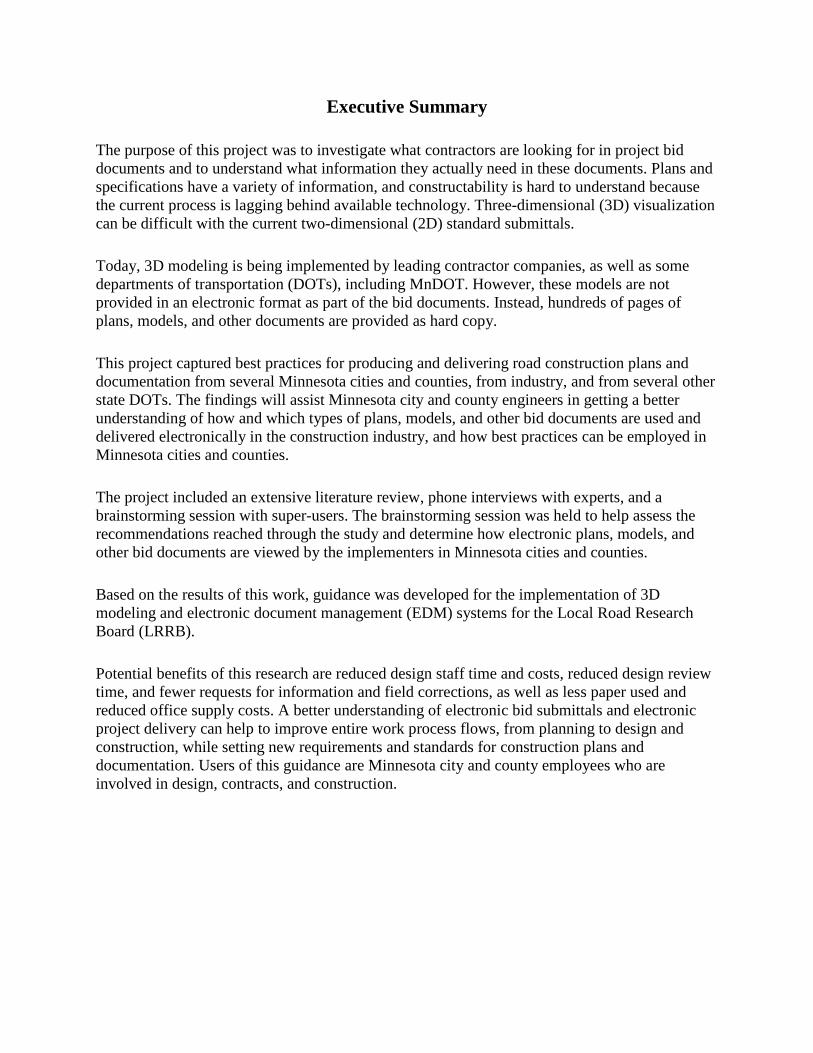
The purpose of this project was to investigate what contractors are looking for in project bid documents and to understand what information they actually need in these documents. Plans and specifications have a variety of information, and constructability is hard to understand because the current process is lagging behind available technology. Three-dimensional (3D) visualization can be difficult with the current two-dimensional (2D) standard submittals.
Today, 3D modeling is being implemented by leading contractor companies, as well as some departments of transportation (DOTs), including MnDOT. However, these models are not provided in an electronic format as part of the bid documents. Instead, hundreds of pages of plans, models, and other documents are provided as hard copy.
This project captured best practices for producing and delivering road construction plans and documentation from several Minnesota cities and counties, from industry, and from several other state DOTs. The findings will assist Minnesota city and county engineers in getting a better understanding of how and which types of plans, models, and other bid documents are used and delivered electronically in the construction industry, and how best practices can be employed in Minnesota cities and counties.
The project included an extensive literature review, phone interviews with experts, and a brainstorming session with super-users. The brainstorming session was held to help assess the recommendations reached through the study and determine how electronic plans, models, and other bid documents are viewed by the implementers in Minnesota cities and counties.
Based on the results of this work, guidance was developed for the implementation of 3D modeling and electronic document management (EDM) systems for the Local Road Research Board (LRRB).
Potential benefits of this research are reduced design staff time and costs, reduced design review time, and fewer requests for information and field corrections, as well as less paper used and reduced office supply costs. A better understanding of electronic bid submittals and electronic project delivery can help to improve entire work process flows, from planning to design and construction, while setting new requirements and standards for construction plans and documentation. Users of this guidance are Minnesota city and county employees who are involved in design, contracts, and construction.
1
CHAPTER 1: INTRODUCTION
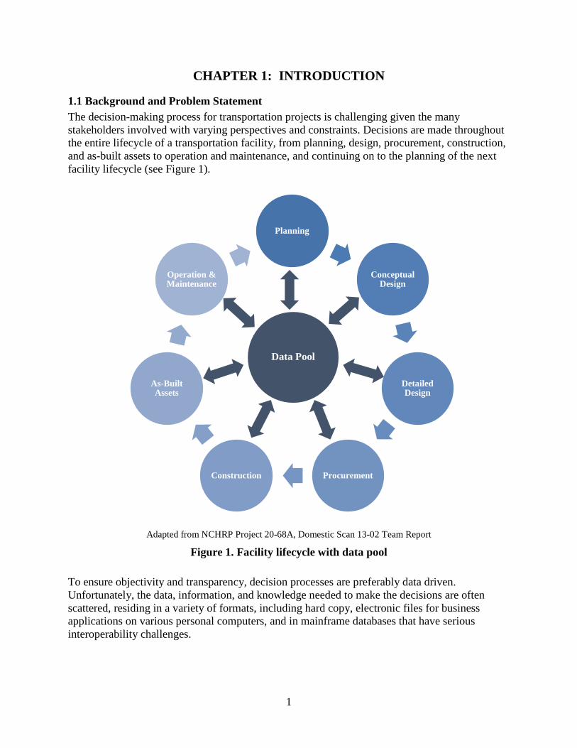
1.1 Background and Problem Statement The decision-making process for transportation projects is challenging given the many stakeholders involved with varying perspectives and constraints. Decisions are made throughout the entire lifecycle of a transportation facility, from planning, design, procurement, construction, and as-built assets to operation and maintenance, and continuing on to the planning of the next facility lifecycle (see Figure 1).
Adapted from NCHRP Project 20-68A, Domestic Scan 13-02 Team Report
Figure 1. Facility lifecycle with data pool
To ensure objectivity and transparency, decision processes are preferably data driven. Unfortunately, the data, information, and knowledge needed to make the decisions are often scattered, residing in a variety of formats, including hard copy, electronic files for business applications on various personal computers, and in mainframe databases that have serious interoperability challenges.
Planning
Conceptual Design
Detailed Design
ProcurementConstruction
As-Built Assets
Operation & Maintenance
Data Pool
2
Development of a system of practices and tools to enable efficient exchange of project data in an electronic format is desirable. This system/process should provide the following:
• A common data, information, and knowledge pool (Figure 1) • Standard processes for transforming data into information and further transforming
information into knowledge • Electronic data transfer protocols • Long term data storage and accessibility
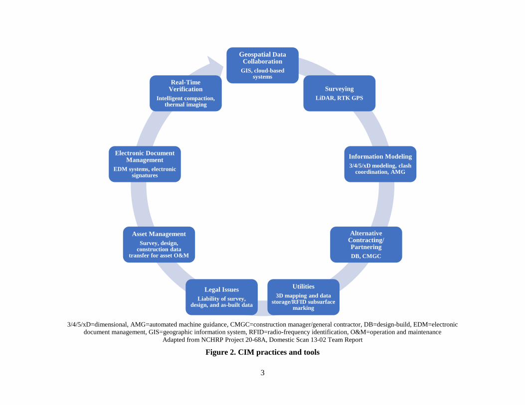
Such a system is defined as civil integrated management (CIM). The core of this system is geotagged asset data including three-dimensional (3D) engineered models, which are compatible with LiDAR, automated machine guidance (AMG) and others (see Figure 2).
3
Geospatial Data Collaboration
GIS, cloud-based systems
SurveyingLiDAR, RTK GPS
Information Modeling3/4/5/xD modeling, clash
coordination, AMG
Alternative Contracting/ PartneringDB, CMGC
Utilities3D mapping and data
storage/RFID subsurface marking
Legal IssuesLiability of survey,
design, and as-built data
Asset ManagementSurvey, design,
construction data transfer for asset O&M
Electronic Document Management
EDM systems, electronic signatures
Real-Time Verification
Intelligent compaction, thermal imaging
3/4/5/xD=dimensional, AMG=automated machine guidance, CMGC=construction manager/general contractor, DB=design-build, EDM=electronic document management, GIS=geographic information system, RFID=radio-frequency identification, O&M=operation and maintenance
Adapted from NCHRP Project 20-68A, Domestic Scan 13-02 Team Report
Figure 2. CIM practices and tools
4
The departure from traditional document-based project delivery and management to a system based on electronic models necessitates redefined workflow processes, raises digital data storage and data interoperability issues, and also awakens legal issues such as the ownership of digital data and models.
Current construction plans and documents do not reflect the needs of today. It is very important to understand what contractors are looking for in project bid documents and to understand what information they actually need. Plans and specifications have a variety of information, and constructability is difficult to understand because the current process is lagging behind available technology.
3D visualization can be difficult with the current two-dimensional (2D) standard submittals. 3D modeling is being implemented by leading contractor companies, as well as some departments of transportation (DOTs), including MnDOT. However, these models are not provided in an electronic format as part of the bid documents. Instead, hundreds of pages of plans, models, and other documents are provided as hard copy.
1.2 Research Methodology and Organization of this Report The purpose of this work was to assist Minnesota city and county engineers in getting a better understanding of how and which types of plans, models, and other bid documents are used and delivered electronically in the construction industry, and how best practices can be employed by their cities and counties. This project involved identifying and documenting best practices in producing and delivering road construction plans and documentation in several Minnesota cities and counties and in industry, as well as in several other DOTs.
This report summarizes the findings of the project. The project was comprised of seven tasks, where the last two tasks were compilation and finalization of this report. The first three tasks involved an extensive literature review and phone interviews with experts to identify and document best practices for road construction plans and documentation. Task 4 involved organizing a super-users’ brainstorming session to understand contractor and consultant needs for road construction plans and documents.
The primary goal of the first three tasks was to identify what contractors are looking for in project bid documents and to understand what information they actually need in them, while capturing best practices for road construction plans and documentation from several Minnesota cities and counties and from industry, as well as several other DOTs. The goal for this work was to increase efficiency by identifying the information in plans that is not useful to contractors for possible elimination from the plans.
This also involved looking at digital practices as more and more contractors are taking advantage of advanced technologies and tools such as 3D modeling, LiDAR, AMG, and others in their practices. Aligning with the scope of this project, the Federal Highway Administration (FHWA) has initiatives that aim to guide and encourage state DOTs to use these new technologies.

5
As part of the FHWA Every Day Counts (EDC)-2 Innovations initiative, 3D engineered models for construction were identified as one of the technologies that should be adopted by state DOTs in the near future. The CIM concept is defined as a comprehensive management system where accurate data are collected, organized, managed, and used throughout the transportation asset lifecycle (NCHRP Domestic Scan 13-02 team n.d.).
The National Cooperative Highway Research Program (NCHRP) funded two projects to investigate the CIM concept: a national domestic scan project that was completed in early 2015 and another research project that is in progress. The principal investigator (PI) on this MnDOT project was heavily involved with the NCHRP CIM domestic scan project, and she visited several state DOTs as well as their contractors and consultants (with the research team) to learn about their practices as they relate to the CIM concept. The practices involve using emerging technologies and tools in an efficient manner to improve current practices.
6
CHAPTER 2: TASK 1 - BEST PRACTICES WITHIN MINNESOTA CITIES AND COUNTIES
The objective of the first task was to establish the current practices of modernized plans within Minnesota, including municipality and county agencies. As part of this task, the research team interviewed engineers from Hennepin and Chisago counties, the City of Rochester, MnDOT, and SRF Consulting Group, Inc.
The researchers asked the questions in Appendix A to help understand the level of adoption of several emerging technologies by Minnesota cities and counties, as well as by MnDOT. The following summarizes the findings and best practices from these interviews.
2.1 3D Modeling Practices Hennepin County has been using MicroStation and InRoads software for highway and road projects for more than 10 years. However, they do not use any 3D bridge design software. For some of their complex bridge projects, consultant engineers model reinforcing steel bar placement in 3D. They do not have any in-house written guidelines on how to use this software; they use software manuals provided by vendors. Most written guidelines are only for the use of different versions of MicroStation, and these guidelines are followed by each design squad. The agency usually keeps the MicroStation most-up-to-date version.
Chisago County has been using GEOPAK and MicroStation since 2013. County employees get software training from vendors. MnDOT also has training programs for some software (e.g., MicroStation training). The triangulated irregular network (TIN) files are created using MicroStation, and, for some of the projects (three projects so far), they share TIN surface models with the contractors. On those projects, contractors use the TIN models on their global positioning system- (GPS)-equipped machines for staking. Compared to traditional surveying, it was more efficient to use a combination of digital TIN models and GPS-equipped machines for staking. The only concern with using TIN files is that, if there is a mistake in the TIN file (either in the model itself or an error occurs during the transmission process), it is difficult to determine who would be responsible for the mistake. They plan to use digital TIN files and GPS-equipped machines for the two major construction projects that will start in 2016. Switching from standard paper plans and specifications to digital, machine-readable plans and models would be a matter of training the current workforce.
The City of Rochester implements 3D modeling for some of their projects. They are using MicroStation and GEOPAK for design, which delivers better accuracy for quantities. Their contractors typically ask for electronic MicroStation files.
MnDOT is currently implementing 3D modeling, but 4D/5D modeling has not been involved in their common practices yet. Southeastern Minnesota has adopted 4D/5D modeling technologies -on their bridge projects. They have developed their own MicroStation computer-aided design (CAD) standards. In 2004, they began to share their 3D models with contractors, including 10 overlay jobs and 15 grading jobs. Benefits were mainly observed in the following domains: machine control, visualization, drainage, and right of way (ROW).
7
SRF Consulting has implemented 3D modeling since 2011. The modeling software packages being used include MicroStation, GEOPAK, AutoCAD Civil 3D, and Navisworks. Usually, 3D models are not shared with others unless clients or contractors specifically request the models. Some challenges are being observed during the implementation of 3D modeling. 3D models are not the required deliverables; therefore, the consultant might not be confident enough to provide models for contractors to use. Most plan sets are still in 2D paper form. On some occasions, such as when dealing with underground conflicts or above-ground clearance, the 3D models are created for quality control and checking purposes. Navisworks is used for a conflict check of the created models to make sure there are zero conflicts in the models. Upon the contractor’s request, the models can be delivered in a format that is preferred. LandXML is the most common format for sharing models.
2.2 Bidding Documents and Digital Signatures Hennepin County uses Adobe software for placing electronic signatures. However, the county attorney is not fully implementing electronic signatures for either pre-bid or post-bid packages. The board of registration is leaning toward using electronic signatures, but there is still a long process before the electronic signatures are put into execution. Eventually, the engineer of record has to take the responsibility for electronic signatures. From a county attorney’s perspective, the questions on the legal aspect are how to obtain those signatures and who is responsible for those signatures.
Chisago County is using the Quest Construction Data Network (CDN) online bidding system to store bidding documents such as drawings and specifications. Contractors can download these files prior to bid. The TIN models are provided only to the winning contractors based on their requests. The current plan and specification packages have appropriate level of details. There are no cases where the design contains unnecessary information or lack of details. TIN files were provided for a couple of projects so far. For those projects, the contractors did not ask for any clarifications. Some of the county designers use electronic signatures to sign drawings, while most employees still use ink signatures. For the general electronic bidding process, no legal issues were observed so far, except for contractors missing bid deadlines occasionally.
The City of Rochester uses electronic signatures except on title pages, which must include an ink signature. The city provides paper plans to their contractors.
Electronic bidding is implemented within MnDOT. They provide electronic portable document format (PDF) plans and specifications for bidding. After bidding, they provide 3D models to the contractor through their file transfer protocol (FTP) site. Contractors typically ask for 3D LandXML breakline data to input into their equipment (Trimble, Topcon, etc.). MicroStation and GEOPAK are used to create 3D breaklines. MnDOT wants to provide contractors what they actually need. They acknowledge it would be nice to have accurate 3D models and to provide those to contractors, rather than using the contractors’ own 3D models. Also, it is important to provide contractors with the file format they actually use. The design software MnDOT uses produces files that are compatible with their contractors’ equipment (either Trimble or Topcon). Currently, MnDOT does not use encrypted electronic signatures, but they are aware of the pilot project on e-signatures in the field by Kentucky and the FHWA.
8
SRF Consulting prepares contract plans both in paper format and PDF, and the signatures would be placed in both hard and digital copies. Before the bidding, only bidding documents and specifications will be provided to bidders, and on some occasions, preliminary engineering reports (e.g., geotechnical reports) will also be provided. MnDOT will provide the necessary documents to winning contractors after bidding. Usually, the consultant does not get any feedback from contractors on the 3D models or digital plans. Electronic signatures are placed on the digital plans by using the tracing signatures function in their CAD product. Paper forms are used to approve the use of electronic signatures.
2.3 Document Management and Data Storage Hennepin County keeps their documents as hard copies. 3D models would be developed for complex projects only, and they would be available during the bidding process to facilitate better understanding of the project. The 3D files will be provided to the winning contractors only if they ask for the models. The contract documents are still hard copies, and the documents are mailed out for signatures. Each page is signed by the engineer and scanned to PDF. The PDF documents are then distributed to other parties. Hennepin County has their own database, called eGram to store the data. No cloud-based solution is used. Most of their long-term data storage is relying on Adobe and MicroStation back-up capabilities. eGram enables them to upload project documents efficiently to its database, and contractors can download those documents from the system.
Chisago County stores its data on their network that is maintained by their information systems department and backed up every day. They do not share their data with other agencies or law enforcement, except for some cases where they share plans, specifications, details, typical section, pay item, and other information if necessary. They have a data retention policy in place, and they store project as-built data for a long time.
MnDOT shares their CAD models and other data through ProjectWise as well as their FTP sites. They keep PDF plans forever, and 3D models are retained for about seven years before they are removed from the database.
2.4 Summary of Interview Results The participants of the survey have different levels of experience on 3D modeling design. Some of them are new users with only one or two years of experience implementing 3D modeling, while others are more advanced with more than 10 years of experience.
Technologies such as LiDAR, topographic survey, and photogrammetry have been used in some counties, but they are not common statewide. Furthermore, even the counties using these technologies are not very experienced with them yet. LiDAR data is beneficial for the project planning phase. Training programs are crucial for employees to be familiar with the new technologies. Training programs are typically provided by vendors, in-house, online, or as a combination of those.
9
Mobile devices have been adopted commonly in the state. Laptops, smartphones, and tablet computers facilitate easy communication among various parties, and can be used for visualizing digital plans and checking the accuracy of 3D models on-site. In addition, mobile devices provide field personnel access to modeling software, management tools, and other online resources.
Several counties are using various forms of contract documents. Some are using hard copies, while others are using digital ones or a combination of both. Electronic signatures are used by some county designers, but they have not been put into full practice yet. Most documents are still kept in hard copies.
3D models are used to help establish a better understanding of the project among all parties. Models are provided to winning contractors upon request. The level of details of currently used in design models and plans seems to be sufficient. However, there are still improvements that need to be made so that road construction models and plans can be used more effectively.
In terms of data storage, agencies usually have their own database/network/file server. Data is maintained and backed up regularly by in-house information technology (IT) personnel. Data retained in the database is not shared with other stakeholders unless when necessary.

10
CHAPTER 3: TASK 2 - BEST PRACTICES IN EUROPEAN COUNTRIES
The second task was to look beyond the borders of US to determine current practices in plan modernization for road and bridge projects. A case study based on the project RV 150 Ring 3 in Ulven-Sinsen, Norway compared the results of using and not using 3D information models (Myllymaa and Sireeni 2013). In the section with no 3D model use, 600 design changes occurred, and, among those, 250 changes resulted from design conflicts that caused $2.4 million in additional costs. In the other section, with 3D model use, no design conflicts or changes occurred in the construction phase; thus, there were no additional costs involved. The Norwegian Road Authority has calculated that the average cost for one conflict or change is about $9,600. This highlights the need for using modern technologies for road and bridge design and construction.
3.1 Visualization With the use of 3D models, the project team and other stakeholders can better visualize various project components and associated systems. This is especially true for underground utilities, in which visualization provided by 3D models allows professionals to easily understand the structure of the underground networks. With a good understanding of the underground networks, project teams could better perform the related maintenance tasks and prevent the possible damage of utilities during excavating work (Du et al. 2006).
3.2 Simulation from the Models Scholtenhuis and Hartmann (2012) conducted a case study on 3D model use for simulations by the road authority and its contractors in the Netherlands. According to this comprehensive study, the benefits of using simulations for road construction projects include helping the project team with the following:
• Better understand the system and ensure the constructability of the design • Evaluate various construction plans and methods in a more efficient way • Predict the impacts of risk factors or uncertainties on a construction process or system • Perform their work better and faster
3.2.1 Challenges with Technology Implementation The major concerns related to providing electronic models/data for contractors include discrepancies between 2D plans and 3D models, claims associated with discrepancies or defects residing in 3D models, and errors or loss of data during the data exchange process (Heikkilä and Jaakkola 2006).
In the roadmap developed by Khosrowshahi and Arayici (2012) for building information modeling (BIM) implementation in the UK construction sector, the challenges associated with the information modeling include the following:
• Personnel’s reluctance to change. Agency needs to have personnel understand the value of modeling and associated new technologies.

11
• The existing workflows should be adjusted to accommodate the need of new technologies. • Training of the modeling tools and process is needed for people to develop or use the models. • Personnel should have a good understanding of the hardware and other resources that support
the modeling software applications and tools. • Collaboration within the disciplines and with other partners are needed to ensure the
successful implementation of 3D/4D models. • The responsibilities of stakeholders in the new process should be clearly defined.
3.3 Lessons Learned/Keys for Successful Implementation Based on the study performed on projects in Northern European countries/Scandinavia, the keys for successful implementation of 3D information models are concluded as follows (Myllymaa and Sireeni 2013):
• Provide proper personnel training on how to use model-related tools and the process for developing and using models.
• Develop standards for model development and related processes. • Use 3D model as the major engineering tool for design analysis, simulation, and
collaboration. 3D models should be updated promptly and used for communication tools during project meetings.
• 3D models should be first implemented on most important disciplines or places with most values.
For large-scale engineering construction in Europe, the most important impact factors from clients’ perspective include the following (Hassan and McCaffer 2002):
• Partnering • Initiative of private finance • More regulations on health and safety • Increased technical input from contractors • Increased risk allocated to contractors • Knowledge exchange between clients • Electronic documentation and digital information • Increased information sharing
12
CHAPTER 4: TASK 3 - BEST PRACTICES IN OTHER AGENCIES AND IN INDUSTRY
The final task involving identifying current practices involve looking in the US at other DOTs for modernizing project plans. Findings presented in this chapter are based on the visits with Iowa, Michigan, New York State, Texas, Utah, Virginia, Michigan, New York State, and Wisconsin DOTs and their contractor and consultant companies as part of the NCHRP Domestic Scan Project 13-02. Much of the material in this chapter is also included in the unpublished NCHRP Domestic Scan 13-02 Team Report that the PI on this MnDOT project contributed to and helped draft.
4.1 Surveying Technologies such as LiDAR, robotic total stations, and real-time kinematic (RTK) GPS devices have been adopted by several agencies. LiDAR refers to “an active sensor system that uses laser light to measure distances.” RTK GPS involves the use of at least two GPS receivers, where at least one receiver is set up over a reference point, while the other receiver (rover) is moved to different locations to take measurements (FHWA 2012). The collected spatial data is used to generate maps and other intermediate electronic data products such as digital terrain models, 3D models, cost estimates, and schedules. The original data can also be retained and accessed by construction, maintenance, and operations personnel as necessary to address the needs of these downstream functions. The initial data collection effort should be well planned to ensure sufficient reliability and accuracy. Also, data should be tied to a robust fixed starting point (a datum, in surveyor’s terms) so it can be used by downstream users.
LiDAR technology enables surveying data collection in an efficient manner and with an adequate level of accuracy. Compared to traditional surveying methods, LiDAR provides better efficiency and improved safety. Technologies like LiDAR and unmanned aerial vehicles (UAVs) provide good-quality results without adding much extra work for surveyors, as long as the right sensors and platforms are selected for the job. Furthermore, LiDAR can be used to collect as-built data for transportation assets, which can be further used for asset management purposes.
Currently, most agencies may not systematically and consistently collect as-built data due to the extra time required and difficulty in storing and integrating these data into their current workflows. Given the example of utilities, few data are collected for as-built conditions of utilities. When a road needs to be reconstructed, agencies need to put considerable time and effort into finding the location and the size of utilities. If a utility is not identified correctly during this initial surveying phase, there are risks of damaging it later during the construction phase, which would result in delays and extra cost. Therefore, it can be concluded that systematically including as-built data in the agency database would help improve asset management practices and rehabilitation of transportation assets.
4.2 3D Modeling Spatially organized information is especially useful for planning, designing, constructing, operating, and maintaining transportation facilities. 3D models provide an excellent electronic visual representation that is intuitive. Data, information, and knowledge are linked to spatial
13
locations and retrieved efficiently. Standardized exchange languages (LandXML, TransXML, IFC, etc.) would be desirable to avoid the loss or damage of data when transferring files from one software system to another.
Initial success is important to provide the necessary momentum to continue 3D model-centric design and construction implementation. When the Iowa DOT initially started 3D modeling, they met with hardware manufacturers such as Trimble, Leica Geosystems, and Caterpillar, Inc. to learn about the future directions for construction hardware and software and planned the future direction for their agency accordingly.
For the first pilot project, they planned a construction project where it was mandatory to use AMG; and thereby the development of a 3D model became necessary. At the end of this first pilot project, they found that 3D model implementation improved communications among stakeholders. Furthermore, they found that the design and its impact to the surrounding environment were better understood by the project stakeholders and the public.
Other benefits of using 3D design models are reduced costs, improved design verification, and AMG with less effort. The following should to be taken into consideration when transitioning into 3D model-centric-based design and construction:
• During the initial implementation stage, agency personnel should engage industry to decide on the electronic file format (e.g., LandXML, TransXML or others). This should not be a project-level decision but rather an agency-level policy.
• Standardized file naming convention is beneficial in file organization and sharing for improved implementation.
• Agencies should consider engaging contractor trade associations to establish standards and procedures for model sharing and keep in contact to adapt to hardware and software improvements. Yearly meetings seem to be appropriate.
Several challenges associated with 3D modeling were observed during the implementation process including the following:
• Lack of sufficient skill sets for 3D model development • Determining the proper level of detail for the design to meet contractors’ needs • Predicting whether the design models would be compatible with contractors’ software or
tools
These challenges have been overcome by several agencies through the following actions:
• Provide manuals and websites to facilitate training • Ensure better quality control as designers gain experience and lean to recognize conflicts by
viewing 3D models • Organize workshops with contractors to find out what they need
14
4.3 Automatic Machine Guidance AMG is an advanced technology that has been identified as beneficial to transportation agencies. AMG technology enables the equipment operator access to 3D design models that are uploaded to on-board computer installed on heavy construction equipment. The operator supervises the machine operation through a computer screen and adjusts its movement accordingly.
Field staff can bring the design models installed on a tablet, coupled with a modern survey device, to the field to compare and verify the as-built conditions with the proposed design. Several state DOTs stated that using AMG in paving reduced the number of survey stakes and string lines, and overall project safety was improved since workers spend less time in the field near heavy construction equipment.
Using modern software applications and experienced staff members, the Iowa DOT asserts that it produces 3D models with no more effort than what was formerly required to produce 2D plans. From contractors’ perspectives, machine control provides the following benefits:
• Increased productivity and accuracy • Improved safety • Faster integration of design changes • More satisfied owners • Fewer errors in the field as it is easier to detect problems by reviewing the 3D/4D models
before the job starts
4.4 Electronic Document Management Systems The use of electronic document management (EDM) systems has become more common among transportation agencies and their partners, especially for design and construction processes. Some agencies choose to use existing commercial products, and some agencies use their own in-house customized software. An EDM system enables all project stakeholders to upload/download project plans and documents. In general, these systems greatly facilitate electronic data exchange and communication among various project stakeholders throughout the project lifecycle.
For example, the Michigan DOT (MDOT) is one of the leaders in implementing advanced EDM systems. They require their contractors to submit documents or models to the electronic file management system they adopted, ProjectWise, which is specifically designed to retain design files, and they plan to implement digital signatures in the near future and to provide access to other project stakeholders.
As mentioned, some agencies use software applications that are developed in-house or customized general-purpose commercial file storage and workflow-facilitating software applications to store and manage their electronic documents. One example is the Utah DOT’s (UDOT’s) Interchange program, which was developed based on a Microsoft SharePoint platform. Prior to program development, the agency first discussed with internal personnel and contractors the workflow and processes. The programming team then executed the development

15
effort based on stakeholder consensus. The resulting product satisfied the need of both the agency and their contractors. The Interchange program supports document submission, task management, meeting minute development, review and distribution, design review, and other capabilities. Various design groups or contractors can submit documents or models to this program, and specify which discipline should review their uploaded documents. When changes are made to a document, the person who is responsible for reviewing it is notified immediately. Through this program, the agency can assign the task to each individual or group as appropriate.
With the increased use of electronic documents, more agencies are expected to implement structured EDM systems to facilitate the need for better exchange of electronic documents and improved communications. In the near future, it is expected that the effective use of these systems will eliminate the need for using paper contract documents.
4.5 Electronic Signatures Digital signatures have been adopted by several agencies and these signatures are facilitated in various ways. MDOT, for example, uses a PDF read/write software application. The Iowa DOT has document management software (called DocuSign) that facilitates digital signatures. There are a number of standards involved in managing the digital signatures that require consideration. However, once the process is set up, it is observed that adoption of electronic signatures increases project productivity, as it enables personnel to sign project plans or documents anytime and anywhere at their convenience.
More effective and common use of electronic signatures should help in implementing electronic construction plans in an efficient manner. With the advances in electronic signature tools, security is no longer an issue. However, legislation enabling the use of digital signatures in Minnesota will be necessary, and policies may also need to be changed within the agencies.
4.6 Data Storage and Management Careful consideration needs to be given for datasets that have large file sizes such as LiDAR point clouds and 3D models. These require considerable storage space at potentially significant annual costs. Several state DOTs perform their data storage and management through annual contracts to IT companies. By outsourcing, agencies could focus more on the project instead of spending time on data storage and management.
16
CHAPTER 5: TASK 4 - BRAINSTORMING SESSION WITH SUPER-USERS
This report aims to provide guidance for the MnDOT Local Road Research Board (LRRB) in implementing the technologies and methods that were selected during task 4. The research team moderated a brainstorming session at the MnDOT Arden Hills Training and Conference Center November 12, 2015 with the team of Minnesota city and county personnel, MnDOT personnel, and other key people, such as designers, construction managers, and inspectors, using the findings from the first three tasks.
The research team delivered a presentation (Appendix B) that was followed by a very good discussion among the attendees on implementation of technologies, such as LiDAR, 3D modeling, AMG, EDM systems, electronic signatures, and mobile devices in their organizations. The discussion involved the advantages and disadvantages of using these technologies, the implementation barriers, possible future opportunities, and the issues that hinders participants’ organizations from going paperless (see Appendix C).
This discussion led the research team and participants to collectively select the top three technologies for further investigation. These technologies were 3D modeling, EDM systems, and legal issues. After the selection of the top three technologies for implementation, a strengths, weaknesses, opportunities, and threats (SWOT) analysis was performed for 3D modeling and EDM systems. The results of the state of the practice work and the SWOT are used as parameters for the Guidelines presented in the next chapter for Task 5.
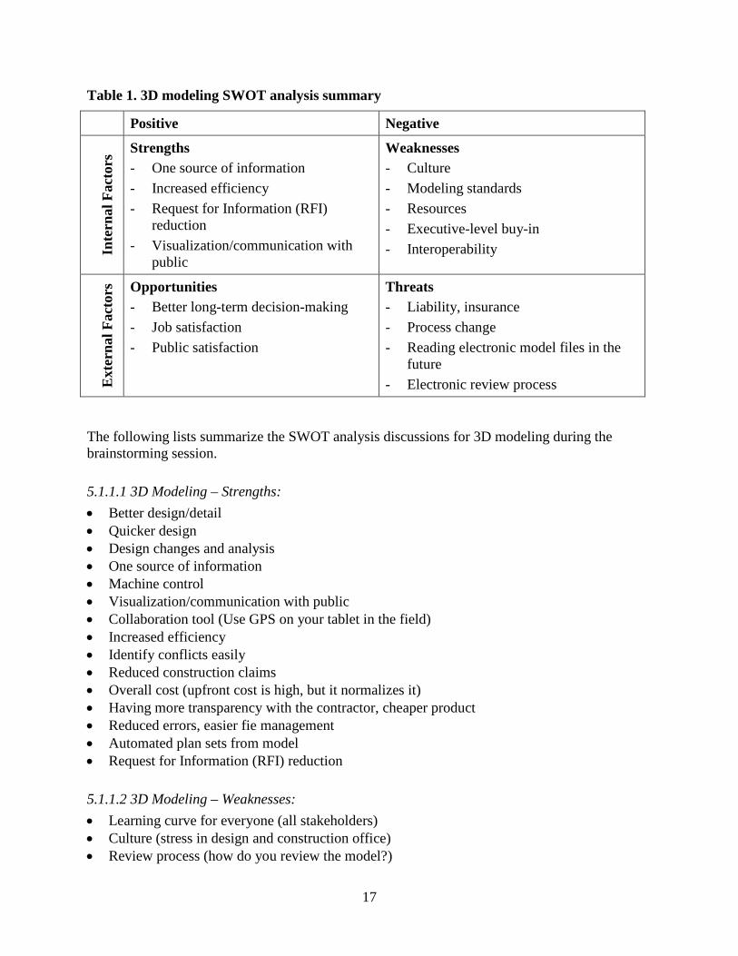
5.1 SWOT Analysis
5.1.1 3D Modeling Spatially organized data and information is very useful for planning, designing, constructing, operating, and maintaining transportation facilities. By using 3D models, the spatial relationship among the various elements of a project can be checked efficiently so that possible conflicts can be resolved virtually before they occur on the jobsite. This ability could greatly reduce the amount of rework and change orders. 3D models could also help expedite quantity take-off and cost-estimating tasks. Furthermore, 3D models are great visualization tools for public communications.
Table 1 summarizes the SWOT analysis conducted for 3D modeling.
17
Table 1. 3D modeling SWOT analysis summary
Positive Negative In
tern
al F
acto
rs Strengths
- One source of information - Increased efficiency - Request for Information (RFI)
reduction - Visualization/communication with
public
Weaknesses - Culture - Modeling standards - Resources - Executive-level buy-in - Interoperability
Ext
erna
l Fac
tors
Opportunities - Better long-term decision-making - Job satisfaction - Public satisfaction
Threats - Liability, insurance - Process change - Reading electronic model files in the
future - Electronic review process
The following lists summarize the SWOT analysis discussions for 3D modeling during the brainstorming session.
5.1.1.1 3D Modeling – Strengths: • Better design/detail • Quicker design • Design changes and analysis • One source of information • Machine control • Visualization/communication with public • Collaboration tool (Use GPS on your tablet in the field) • Increased efficiency • Identify conflicts easily • Reduced construction claims • Overall cost (upfront cost is high, but it normalizes it) • Having more transparency with the contractor, cheaper product • Reduced errors, easier fie management • Automated plan sets from model • Request for Information (RFI) reduction
5.1.1.2 3D Modeling – Weaknesses: • Learning curve for everyone (all stakeholders) • Culture (stress in design and construction office) • Review process (how do you review the model?)
18
• Resources – both $ and human resources • Hardware • More designers/less construction people dealing with problems on the site (mindset change) • Governance structure, modeling standards (current weakness) • Engage contractors more • Project size/level of detail – one size does not fit all, e.g., pavement preservation project
(single source of data) • Progression of the software – new version every year • Workflow change – required • Interoperability issues/software limitations – software will get there • Executive-level buy-in – this is one of the biggest hurdles • Accuracy of the proposed model – your model is as good as your previous survey model/2D
plans • Liability – utilities are the worst! Ask utility companies XYZ, GIS companies
5.1.1.3 3D Modeling – Opportunities: • Cost savings • Evolving technology • Ability to show public that 3D modeling is a must – show its capabilities • Taking advantage of current technology • ROW acquisition – easier to show/plan on a 3D model – communication with property
owners is difficult when using plans if they don’t know how to read plans • Dynamic and efficient – quick design changes – much easier than changing 50 plans, less
work • Ability to use 3D models for AMG, eliminate errors in the field • People enjoy their work better – job satisfaction, which would lead to increased efficiency • Streamline design-construction flow process • Conflict analysis (clash coordination software) is easier to do • Take up quantities from the model • Asset management – 3D model could be used • 4D modeling (staging the construction) would be very beneficial – examples from the
building industry • Better long-term decisions • Public satisfaction • Building industry has been using 3D information modeling since mid-2000s – learn from the
building industry, get in touch with BIM/virtual design construction (VDC) people of general contractors (GC)
5.1.1.4 3D Modeling – Threats: • Reading electronic model files in the future – due to software changes and incompatibility
issues • Design standards • Process change
19
• Cost of hardware, learning curve cost • Liability, insurance • Staff buy-in (all parties, including designer and contractor) • Document approval • Information storage (managing data) and internet connection (so you can share files) • Job security – employee needs to learn how to use 3D modeling software – employee needs
to learn how to use a computer • Small business investment • Designer’s role change (back to master builder) • Electronic review process – more seasoned engineers may not be able to provide feedback on
review, since they are used to reviewing 2D plans
5.1.2 EDM Systems EDM systems have become more crucial to the transportation industry as more advanced tools and automated process have been adopted. Prior to the adoption of EDM systems, piles of paper plans or other documents had to be handed back and forth within agencies and/or between various parties. Considerable time and cost were spent on printing and shipping hard copy documents during the duration of a typical project.
With the adoption of EDM systems, personnel form various stakeholders can easily submit documents to the same platform, and other users involved with the project or a particular task can view the submitted documents and provide comments, concurrence, and approvals. Furthermore, certain engineering products, such as 3D models must be delivered electronically, because they cannot be easily converted to hard copies. EDM systems eliminate the need for printing and shipping documents among various parties (Sulankivi et al. 2002).
Moreover, the documents or models might be stored in the system as permanent records if necessary, so that stakeholders can extract and use them in the future. Some agencies prefer to use commercially available products such as ProjectWise and SharePoint, while some use customized, in-house products. EDM facilitates faster, centralized communication between various stakeholders. For example, a designer can upload the project model and other documents to the EDM system, and contractors can download these documents and upload their documents using the same system.
Table 2 summarizes the SWOT analysis results for EDM systems.
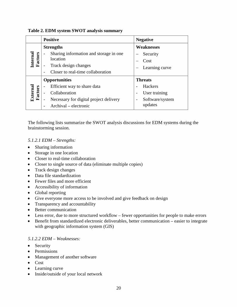
20
Table 2. EDM system SWOT analysis summary
Positive Negative In
tern
al
Fact
ors
Strengths - Sharing information and storage in one
location - Track design changes - Closer to real-time collaboration
Weaknesses − Security − Cost − Learning curve
Ext
erna
l Fa
ctor
s
Opportunities - Efficient way to share data - Collaboration - Necessary for digital project delivery - Archival – electronic
Threats - Hackers - User training - Software/system
updates
The following lists summarize the SWOT analysis discussions for EDM systems during the brainstorming session.
5.1.2.1 EDM – Strengths: • Sharing information • Storage in one location • Closer to real-time collaboration • Closer to single source of data (eliminate multiple copies) • Track design changes • Data file standardization • Fewer files and more efficient • Accessibility of information • Global reporting • Give everyone more access to be involved and give feedback on design • Transparency and accountability • Better communication • Less error, due to more structured workflow – fewer opportunities for people to make errors • Benefit from standardized electronic deliverables, better communication – easier to integrate
with geographic information system (GIS)
5.1.2.2 EDM – Weaknesses: • Security • Permissions • Management of another software • Cost • Learning curve • Inside/outside of your local network
21
• Corrupt file – what do you do with it? • Power outage • Server failure • Broadband needed • Different EDM systems • IT Department implementation
5.1.2.3 EDM – Opportunities: • Efficient construction – Addendum, etc. • Collaboration • Necessary for 3D modeling • Archival – electronic • Most efficient way to share data – manage current design for future storage
5.1.2.4 EDM – Threats: • Hackers • Multiple systems (Bentley, Autodesk, etc.) • Train users • Changes to software • Disaster recovery • Fit real-world
5.2 Barriers and Challenges to Digital Project Delivery After completing the SWOT analysis, the researchers asked participants the following questions to identify major issues that prevent them from switching to digital project delivery, and to identify possible solutions. Participant responses are listed below each question.
1. What hinders agencies/people from going paperless? • General reluctance to change • Contractual obligations • Legal issues/barriers • Integration – integrated project delivery (IPD)/design-build (DB) methods would be
much better fit for collaboration • Insurance needs to change – legal system needs to change • Lack of information on savings to overcome these challenges
2. What would you like to see change? • Executive people should buy into it, get them involved. • Agreement with architect – signing waivers; general contractor (GC) delivers a 3D model
but signs a waiver because 3D model is not one of the deliverables. This would need to change. Making 3D models one of the deliverables would reduce the level of risk.
• Level of Design (LoD) of the model – you can use the model to construct/fabricate from it, and for sequencing (4D model). Have agreements with designers.
22
• Review of the contract documents – 2D versus 3D. • Project delivery method. Have more DB projects. • Decrease required paper plans (put them as PDF in the EDM system), and increase model
use incrementally.
5.3 Key Findings The benefit/cost of 3D modeling on larger projects are higher right now, but, over time, the benefit to all projects will be high.
• 3D and EDM need to go hand in hand. • 3D model data needs to be part of the bid package and, therefore, needs to be certified by the
professional engineer (PE), and liability concerns need to be overcome. • Civil engineering education and training need to change to the 3D and EDM (CIM) world.
This includes engineering technician courses. Software companies need to provide their products to students to learn. A CIM curriculum needs to be developed for universities and technical colleges.
• Industry culture needs to adapt to allow technical experts to remain in their roles and be adequately compensated.
• Senior engineers and construction inspectors need to document what they look for in a successful construction plan.
• Contractors need to provide input into what makes a successful construction plan. • For counties and cities to use CIM, someone will need to develop the standards and be
willing to do a pilot project. State aid will need to be a strong supporter.
23
CHAPTER 6: TASK 5 - GUIDELINES
Based on the literature review and interviews conducted in tasks 1, 2, and 3 and the super-users’ brainstorming session conducted in task 4, guidance was developed for the implementation of 3D modeling and EDM systems for the LRRB. This guidance aims to provide some steps for the incorporation of 3D modeling and EDM systems in the design, bid, and construction processes of Minnesota cities and counties. This guidance does not include tool development, nor does it include implementation by Minnesota cities and counties.
6.1 Key Findings New technologies such as LiDAR, 3D modeling, AMG, EDM systems, electronic signatures, and mobile devices have been adopted at a slower rate in the horizontal construction industry than in the building industry. However, the interest in implementing these technologies has been steadily increasing among the stakeholders of horizontal infrastructure projects.
During task 4 of this project, 3D modeling and EDM systems were found to be the most important technologies to implement to modernize construction plans and move toward digital project delivery by the participating agencies. The following fundamental concepts that facilitate 3D modeling and EDM systems implementation are recommended as starting considerations for Minnesota cities and counties.
6.2 Fundamental Concepts While developing the guidance for modernizing plans, a set of fundamental concepts were used, as follows:
• Promote innovation within the whole agency • Employ model-based design (3D modeling) within the agency as a starting point for moving
toward paperless • Use common exchange formats to facilitate wide sharing of data • Collaborate with contractors and consultants to enhance the usefulness of model-based
design and construction • Adopt an EDM system that best suits agency needs and resources
These concepts were considered for several reasons, including ease of the transition based on the information obtained throughout this project.
6.3 Recommended Procedures for Successful Implementation
6.3.1 3D Modeling Implementation of 3D modeling is expected to greatly reduce the volume of paper construction plans. However, because of legal issues, 3D modeling is not being considered part of the bid documents and is one of the major factors preventing agencies from going paperless. Making changes to the legal aspects of contract documents may take a long time.
24
Currently, some DOTs, including Iowa, Michigan, and Oregon, have been using electronic signatures to sign off on some project documents, including cross sections that they produce from 3D models. However, these states still require an ink signature and seal on the title page of project plan sets, as required by law, and the remainder of the pages can be signed electronically. Engineers do not feel comfortable signing project plan sets electronically due to liability issues.
The results of this project include recommendations that Minnesota cities and counties start using 3D modeling for all of their projects (making it a policy), start establishing modeling standards within the agency, and share the models, along with 2D cross sections and plans that are produced from the 3D models, in electronic PDF format. Given that the legal requirements remain the same, some of these 2D cross sections and plans (aligning with the agency requirements) will still need to be provided to contractors in hard copy and signed with ink (but not necessarily all of them).
Making 3D modeling a policy for the agency and providing these models to contractors is expected to help reduce the volume of paper plans and documents, as well as increase efficiency in the design and construction phases. Recommended steps or actions for 3D modeling implementation are as follows:
• Executive-level buy-in (convince decision makers within the agency to switch to 3D modeling agency-wide).
• Investments required for 3D modeling software and hardware (computers with high computing capabilities).
• The return on investment (ROI) numbers included in the McGraw Hill Construction SmartMarket report on the business value of BIM for infrastructure can be used to convince decision makers and to get them to invest in hardware and 3D modeling software (McGraw Hill Construction 2012).
• Staff training on 3D modeling software (MicroStation or Autodesk AutoCAD Civil 3D).
• Develop design standards for 3D modeling that suits the individual agency.
• Make 3D modeling use compulsory for design and share the models with contractors and consultants as part of the bid documents (even though they are not legally required). To protect the agency’s liability, have contractors and consultants sign a liability form with the receipt of the 3D model. Several DOTs, including Iowa and Wisconsin, have been dealing with the liability issue this way. For example, the Iowa DOT still considers the paper set the “signed and sealed” data, and the contractor is responsible to construct in accordance with the “signed and sealed” plan set (Reeder and Nelson 2015). So far, this has been proven to be the best practice since the contract language has not yet been changed for any state DOT.
• Determine the file format(s) that suit(s) the individual agency, and communicate this with the consultants and contractors to overcome the interoperability issues.

25
• Develop all the plan sets and cross sections from 3D models, and share them with contractors in electronic format along with the 3D model.
• At the end of the construction, agencies should require contractors to provide as-built 3D models, which are verified by the agencies.
Figure 3 shows a probable 3D modeling implementation flow.

26
Figure 3. 3D modeling implementation flow
Executive-Level Buy-In
• Convince decision makers within the agency to switch to 3D modeling agency wide
• Use the return on investment (ROI) numbers included in the SmartMarketReport on the business value of BIM for infrastructure
Investments Required for 3D
Modeling
• Investments required for 3D modeling software and hardware (computers with high computing capabilities)
• Staff training on 3D modeling software (MicroStation or Autodesk AutoCAD Civil 3D)
• Adopt design standards (developed by MnDOT) for 3D modeling
3D Modeling Implementation
• Follow a stepped approach for utilizing 3D modeling: start using 3D modeling for public communication first, then preliminary design, before using it for design and construction
Interoperability
• Determine the file format(s) that suit(s) your agency, and communicate this with your consultants and contractors to overcome the interoperability issues
Small Pilot Project
• Require 3D modeling use for design and construction and share the models with contractors as part of the bid documents (even though they are not legally required)
• Develop all the plan sets and cross sections from 3D models, and share them with contractors in electronic format (PDF)
• Request as-built 3D models from contractors
27
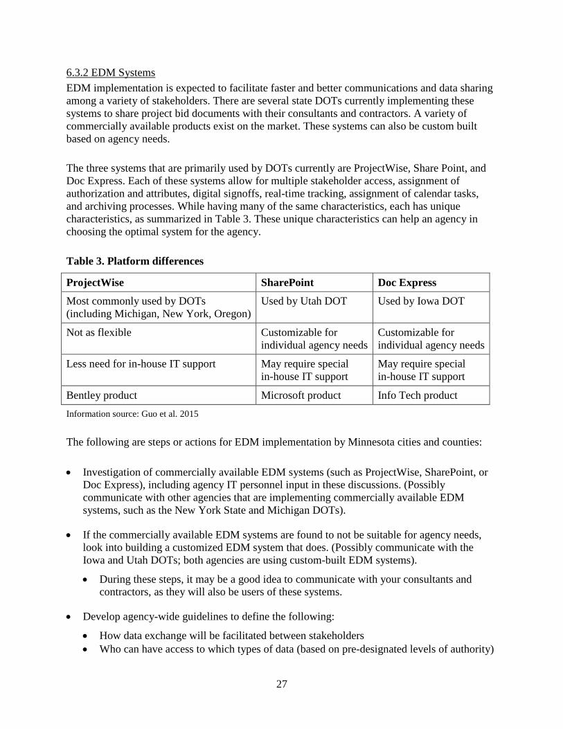
6.3.2 EDM Systems EDM implementation is expected to facilitate faster and better communications and data sharing among a variety of stakeholders. There are several state DOTs currently implementing these systems to share project bid documents with their consultants and contractors. A variety of commercially available products exist on the market. These systems can also be custom built based on agency needs.
The three systems that are primarily used by DOTs currently are ProjectWise, Share Point, and Doc Express. Each of these systems allow for multiple stakeholder access, assignment of authorization and attributes, digital signoffs, real-time tracking, assignment of calendar tasks, and archiving processes. While having many of the same characteristics, each has unique characteristics, as summarized in Table 3. These unique characteristics can help an agency in choosing the optimal system for the agency.
Table 3. Platform differences
ProjectWise SharePoint Doc Express
Most commonly used by DOTs (including Michigan, New York, Oregon)
Used by Utah DOT Used by Iowa DOT
Not as flexible Customizable for individual agency needs
Customizable for individual agency needs
Less need for in-house IT support May require special in-house IT support
May require special in-house IT support
Bentley product Microsoft product Info Tech product Information source: Guo et al. 2015
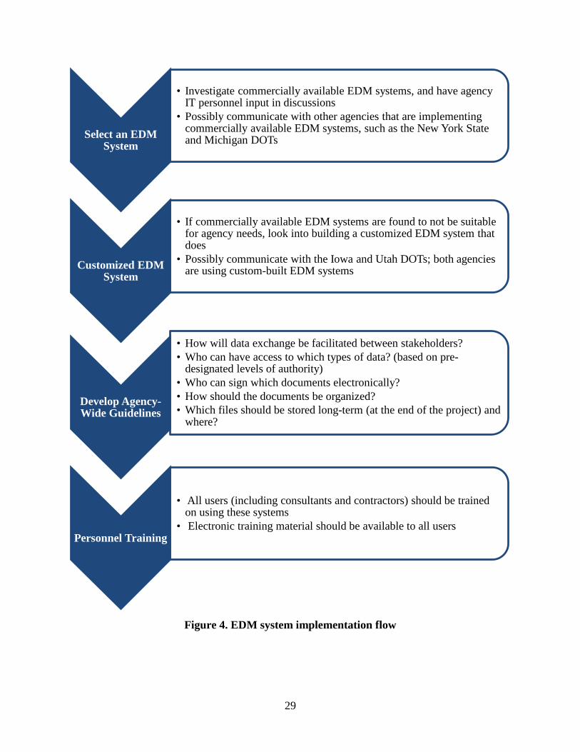
The following are steps or actions for EDM implementation by Minnesota cities and counties:
• Investigation of commercially available EDM systems (such as ProjectWise, SharePoint, or Doc Express), including agency IT personnel input in these discussions. (Possibly communicate with other agencies that are implementing commercially available EDM systems, such as the New York State and Michigan DOTs).
• If the commercially available EDM systems are found to not be suitable for agency needs, look into building a customized EDM system that does. (Possibly communicate with the Iowa and Utah DOTs; both agencies are using custom-built EDM systems).
• During these steps, it may be a good idea to communicate with your consultants and contractors, as they will also be users of these systems.
• Develop agency-wide guidelines to define the following:
• How data exchange will be facilitated between stakeholders • Who can have access to which types of data (based on pre-designated levels of authority)
28
• Who can sign which documents electronically • How the documents should be organized • Which files should be stored long-term (at the end of the project), and where.
• All users should be trained on using these systems, and electronic training material should be available to all users.
Figure 4 shows a probable EDM system implementation flow.
29
Figure 4. EDM system implementation flow
Select an EDM System
• Investigate commercially available EDM systems, and have agency IT personnel input in discussions
• Possibly communicate with other agencies that are implementing commercially available EDM systems, such as the New York State and Michigan DOTs
Customized EDM System
• If commercially available EDM systems are found to not be suitable for agency needs, look into building a customized EDM system that does
• Possibly communicate with the Iowa and Utah DOTs; both agencies are using custom-built EDM systems
Develop Agency-Wide Guidelines
• How will data exchange be facilitated between stakeholders? • Who can have access to which types of data? (based on pre-
designated levels of authority)• Who can sign which documents electronically? • How should the documents be organized? • Which files should be stored long-term (at the end of the project) and
where?
Personnel Training
• All users (including consultants and contractors) should be trained on using these systems
• Electronic training material should be available to all users
30
CHAPTER 7: CONCLUSIONS
Several emerging advanced technologies are being adopted by the transportation industry. The most common technologies employed by other state DOTs and by the road authorities of European countries include 3D/4D information modeling, LiDAR, and AMG. Each of these technologies has its own advantages and application areas. Mobile devices, EDM systems, and electronic signatures have also been adopted to support use of these technologies.
More common use of EDM systems and electronic signatures will help in moving toward digital project delivery and modernizing current construction contract plans and documents. Adoption of these technologies enables agencies to perform their work faster and better.
The transportation industry has a general trend of adopting new advanced technologies based on their high efficiency and accuracy. Mobility is another key factor for adoption of these technologies. Improved mobility enables workers to perform their tasks in an efficient manner and establish instant communication with others. Mobile devices give workers access to the design models, specifications, and other online resources at the same time. Thus, overall productivity could be greatly improved with the adoption of these tools and technologies.
On the other hand, challenges exist with the implementation of new technologies and tools. Personnel’s resistance to change or institutional barriers might delay the process of adopting new technologies. To effectively use some of these technologies, traditional workflows may need to be adjusted. In addition, personnel need to not only have the professional knowledge but also the skills to use new tools. This requires the agency to provide proper training to ensure personnel are capable of performing the related tasks using the new tools. Standards need to be developed for using new technologies and tools in a systematic way. Additional collaboration with other disciplines might be necessary in some cases. Furthermore, responsibilities must be assigned properly and clearly to the related groups.
Overall, advanced technologies have proved to be beneficial to transportation agencies and contractors. This project team recommends that agencies implement these technologies on a small scale (e.g., projects with the most ROI value) first, and then expand to full scale after having some experience. The team also recommends that agencies communicate more and share lessons learned to realize the greatest benefits from use of each particular technology and tool.
31
CHAPTER 8: LIMITATIONS AND FUTURE WORK
As with all research work, there are limitations to the findings, guidance, and conclusions included in this report. The limitations include the number of participants and implementation.
The primary limitation of this research was the number of participants in the study. A limited number of participants were included in both the interviews and the super-user group. The limited number of interviews was due to limited resources and ability to conduct interviews. Strategically, only a small number of super-users were included in the super-user group. This group was selected based on the participants’ knowledge and experience—both with the technologies to be discussed as well as with work within Minnesota.
While guidance is provided for implementation of the findings for 3D modeling and EDM systems, limitations for these technologies must be overcome for full implementation. Some of these limitations, such as changes to legislation, were beyond the work of the research team. However, the limitations of implementation are possible future work.
Future work should focus on implementing the findings of this project on a small-scale project that is led by one of the Minnesota cities or counties. One way this project may be completed is by using an action research methodology. Action research involves a cycle of plan, act, observe, reflect, and repeat. Changes are made during the plan portion of each cycle. The cycle is repeated until the project team members are satisfied that the option has been fully explored and the adjustments are implemented. In this case, the team may include actual researchers as well as the LRRB and users of the technologies (i.e., designers, contractors, inspectors, city/county personnel).
An additional limitation for EDM system implementation is the need to either develop or utilize an existing system. While guidance for implementing an EDM system is provided in this report, it lacks suggestions on the EDM system. Examples of commercial and home-grown versions are available in industry. Each city/county will need to select which system is best.
Commercial systems may be easier to introduce quickly, but they may not allow for customization to fully fit the users’ needs. Home-grown EDM systems take longer to develop because they are custom-built in-house or with a consultant. However, these systems can be customized to the user. Additional considerations include updates to new software, longevity of the system, up-keep costs, and user learning curve.
Additional research work may include an investigation of specific systems to determine if a commercial product will fit the needs of users. If not, and a home-grown version is required, there may be additional work to determine the specific needs, including information, file type(s), and access.

32
REFERENCES
Du, Y., S. Zlatanova, and X. Liu. 2006. Management and 3D visualization of pipeline networks using DBMS and AEC software. Proceedings of the ISPRS Technical Commission IV Symposium on Geospatial Databases for Sustainable Development, 27–30. Goa, India, September 27-30, 2006.
FHWA. 2012. Chapter 5: Surveying and Mapping in Project Development and Design Manual. Federal Highway Administration, Washington, DC. URL: flh.fhwa.dot.gov/business/resources/design/pddm/Chapter_05.pdf. (Last accessed August 3, 2016.)
Guo, F., C. T. Jahren, and Y. Turkan. 2015. Electronic Document Management Systems for Transportation Construction Industry. 5th International/11th Construction Specialty Conference, Vancouver, BC, June 8-10, 2015.
Hassan, T. M., and R. McCaffer. 2002. Vision of the large scale engineering construction industry in Europe. Automation in Construction, 11(4), 421–437.
Heikkilä, R., and M. Jaakkola. 2006. Automation of road construction-the state of the art in Europe. 23th International Symposium on Automation and Robotics in Construction. ISARC, Tokyo, Japan, October 3-5, 2006.
Khosrowshahi, F., and Y. Arayici. 2012. Roadmap for implementation of BIM in the UK construction industry. Engineering, Construction and Architectural Management, 19(6), 610–635.
McGraw Hill Construction. 2012. The Business Value of BIM: Addressing America’s Infrastructure Challenges with Collaboration and Technology SmartMarket Report. McGraw Hill Construction Research and Analytics/Industry Insights and Alliances, Bedford, MA. URL: images.autodesk.com/adsk/files/business_value_of_bim_for_infrastructure_smartmarket_report__2012.pdf. (Last accessed August 8, 2016.)
Myllymaa, J., and J. Sireeni. 2013. Cost Savings by Using Advanced VDC Tools and Processes, Case Studies from Europe. URL: ebookbrowsee.net/sireenijarkko-cost-savings-by-using-advanced-vdc-tools-and-processes-case-studies-from-europe-pdf-d727336225. (Accessed September 8, 2014.)
NCHRP Domestic Scan 13-02 team. no date. Advances in Civil Integrated Management. NCHRP Project 20-68A Scan 13-02 Team Report. Unpublished.
Reeder, G. D., and G. A. Nelson. 2015. Implementation Manual—3D Engineered Models for Highway Construction: The Iowa Experience. National Concrete Pavement Technology Center, Institute for Transportation, Iowa State University, Ames, IA. URL: publications.iowa.gov/20318/1/IADOT_InTrans_RB33_014_Reeder_Implementation_Manual_3D_Engineered_Models_Highway_Const_2015_Final.pdf. (Last accessed August 3, 2016.)
olde Scholtenhuis, L. L., and T. Hartmann. 2012. An object model to support visualizations and simulations of subsurface utility construction activities. Proceedings of 14th International Conference on Computing in Civil and Building Engineering, 1–7. Moscow, Russia, June 27-29, 2012.

33
Sulankivi, K., A. Lakka, and M. Luedke. 2002. Project Management in the Concurrent Engineering Environment. VTT Building and Transport Technical Research Centre of Finland, Espoo, Finland. URL: www.vtt.fi/inf/pdf/publications/2002/P470.pdf. (Last accessed August 3, 2016.)

APPENDIX A. INTERVIEW QUESTIONNAIRE
A-1
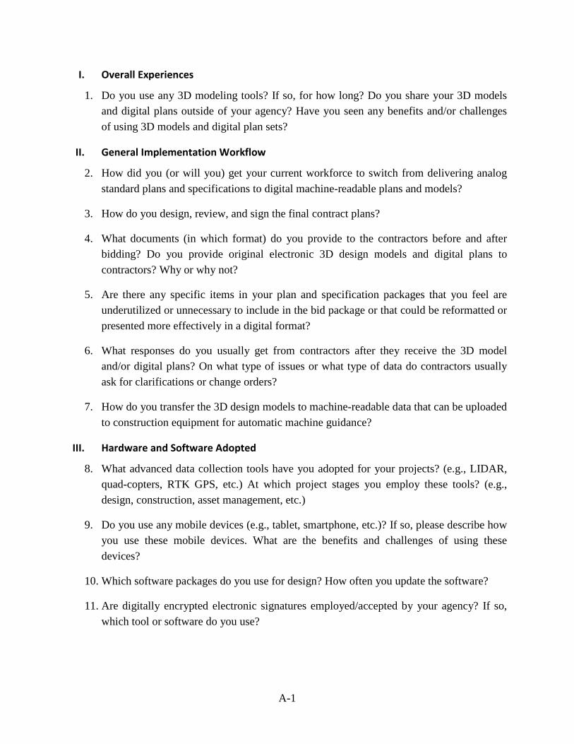
I. Overall Experiences
1. Do you use any 3D modeling tools? If so, for how long? Do you share your 3D models and digital plans outside of your agency? Have you seen any benefits and/or challenges of using 3D models and digital plan sets?
II. General Implementation Workflow
2. How did you (or will you) get your current workforce to switch from delivering analog standard plans and specifications to digital machine-readable plans and models?
3. How do you design, review, and sign the final contract plans?
4. What documents (in which format) do you provide to the contractors before and after bidding? Do you provide original electronic 3D design models and digital plans to contractors? Why or why not?
5. Are there any specific items in your plan and specification packages that you feel are underutilized or unnecessary to include in the bid package or that could be reformatted or presented more effectively in a digital format?
6. What responses do you usually get from contractors after they receive the 3D model and/or digital plans? On what type of issues or what type of data do contractors usually ask for clarifications or change orders?
7. How do you transfer the 3D design models to machine-readable data that can be uploaded to construction equipment for automatic machine guidance?
III. Hardware and Software Adopted
8. What advanced data collection tools have you adopted for your projects? (e.g., LIDAR, quad-copters, RTK GPS, etc.) At which project stages you employ these tools? (e.g., design, construction, asset management, etc.)
9. Do you use any mobile devices (e.g., tablet, smartphone, etc.)? If so, please describe how you use these mobile devices. What are the benefits and challenges of using these devices?
10. Which software packages do you use for design? How often you update the software?
11. Are digitally encrypted electronic signatures employed/accepted by your agency? If so, which tool or software do you use?
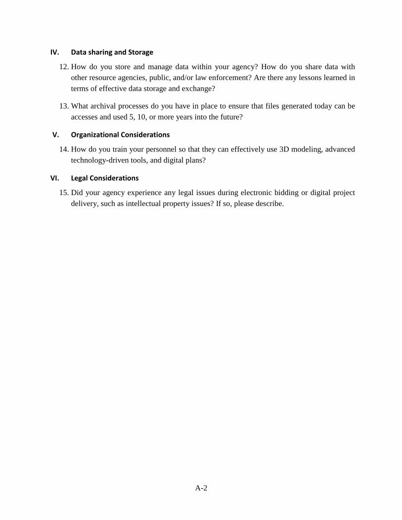
A-2
IV. Data sharing and Storage
12. How do you store and manage data within your agency? How do you share data with other resource agencies, public, and/or law enforcement? Are there any lessons learned in terms of effective data storage and exchange?
13. What archival processes do you have in place to ensure that files generated today can be accesses and used 5, 10, or more years into the future?
V. Organizational Considerations
14. How do you train your personnel so that they can effectively use 3D modeling, advanced technology-driven tools, and digital plans?
VI. Legal Considerations
15. Did your agency experience any legal issues during electronic bidding or digital project delivery, such as intellectual property issues? If so, please describe.

APPENDIX B. SUPER-USERS’ BRAINSTORMING SESSION PRESENTATION
B-1
Modernizing Road Construction Plans and Documentation
Task 4: Brainstorming Session
November 12, 2015, MnDOT Training Center at Arden Hills

B-2
Agenda
8:30 – 9:00 Introduction & CIM technologies 9:00 – 9:45 Discussion on advantages and disadvantages of the CIM technologies presented 9:45 – 10:00 Discussion on any other CIM-related technologies 10:00 – 10:15 Coffee Break 10:15 – 10:30 Select top two or three CIM technologies for implementation 10:30 – 11:00 SWOT Analysis for the top one or two CIM Technologies 11:00 – 12:00 Discussion on Barriers & Challenges for Implementation 12:00 Adjourn
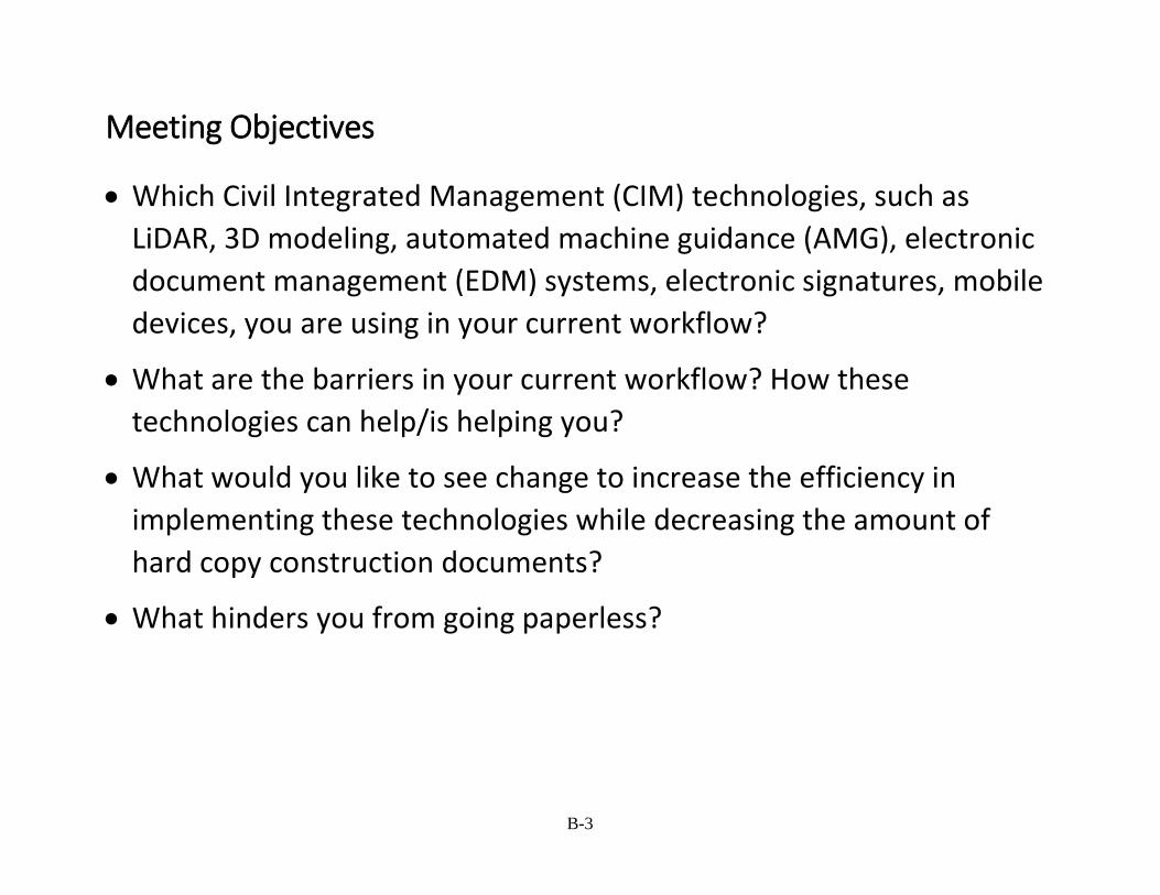
B-3
Meeting Objectives
• Which Civil Integrated Management (CIM) technologies, such as LiDAR, 3D modeling, automated machine guidance (AMG), electronic document management (EDM) systems, electronic signatures, mobile devices, you are using in your current workflow?
• What are the barriers in your current workflow? How these technologies can help/is helping you?
• What would you like to see change to increase the efficiency in implementing these technologies while decreasing the amount of hard copy construction documents?
• What hinders you from going paperless?
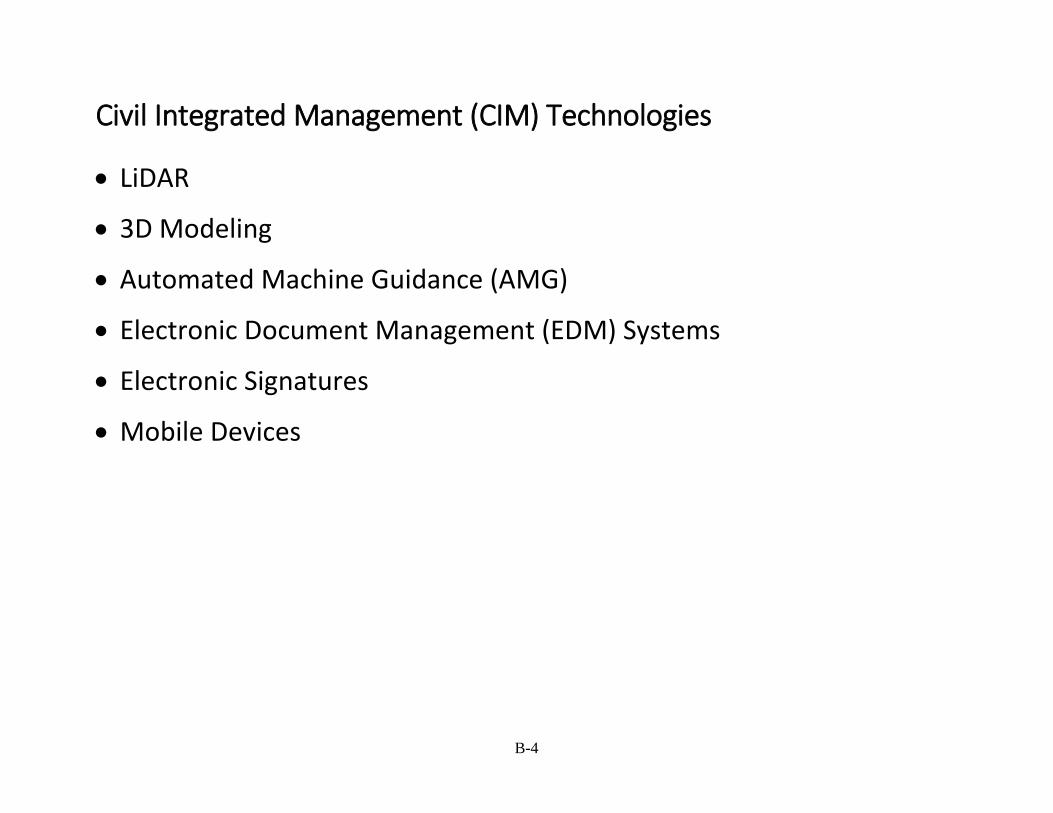
B-4
Civil Integrated Management (CIM) Technologies
• LiDAR
• 3D Modeling
• Automated Machine Guidance (AMG)
• Electronic Document Management (EDM) Systems
• Electronic Signatures
• Mobile Devices
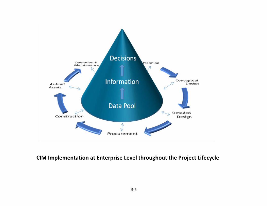
B-5
CIM Implementation at Enterprise Level throughout the Project Lifecycle
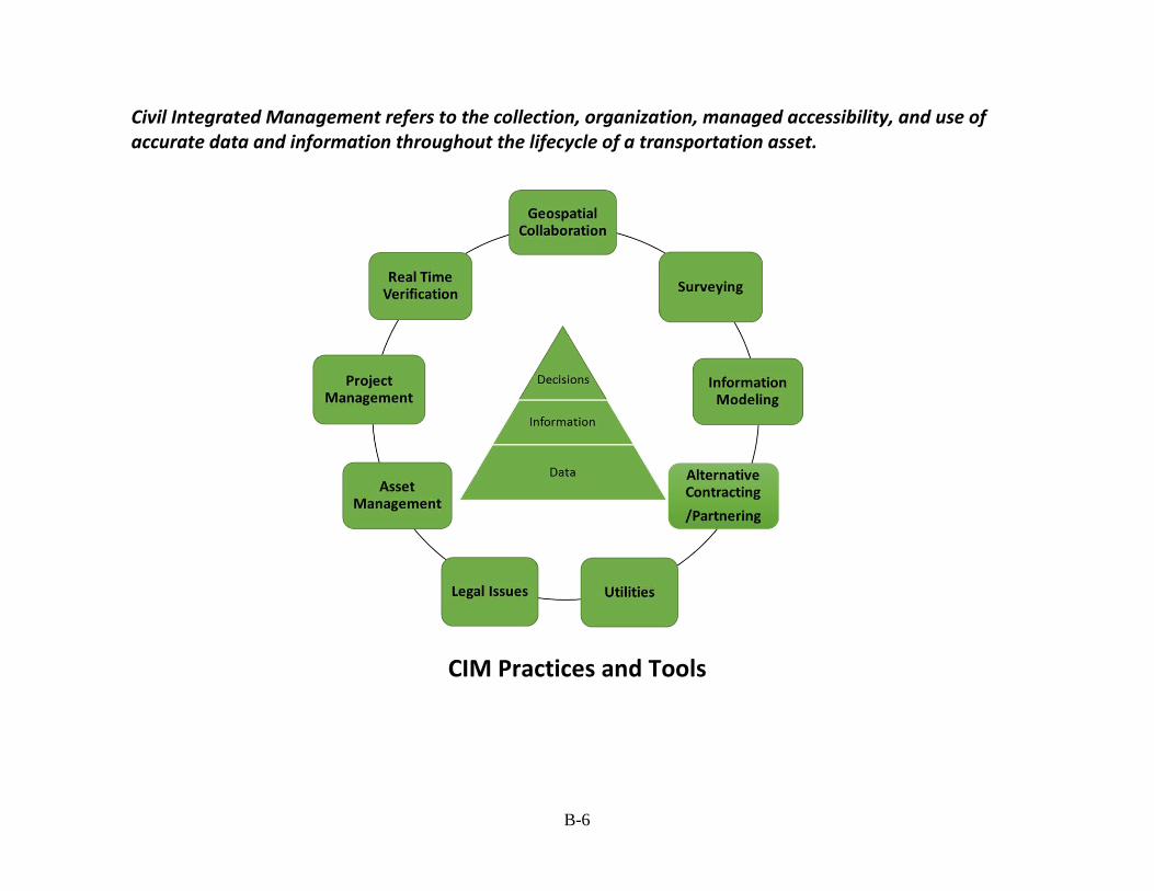
B-6
Civil Integrated Management refers to the collection, organization, managed accessibility, and use of accurate data and information throughout the lifecycle of a transportation asset.
CIM Practices and Tools
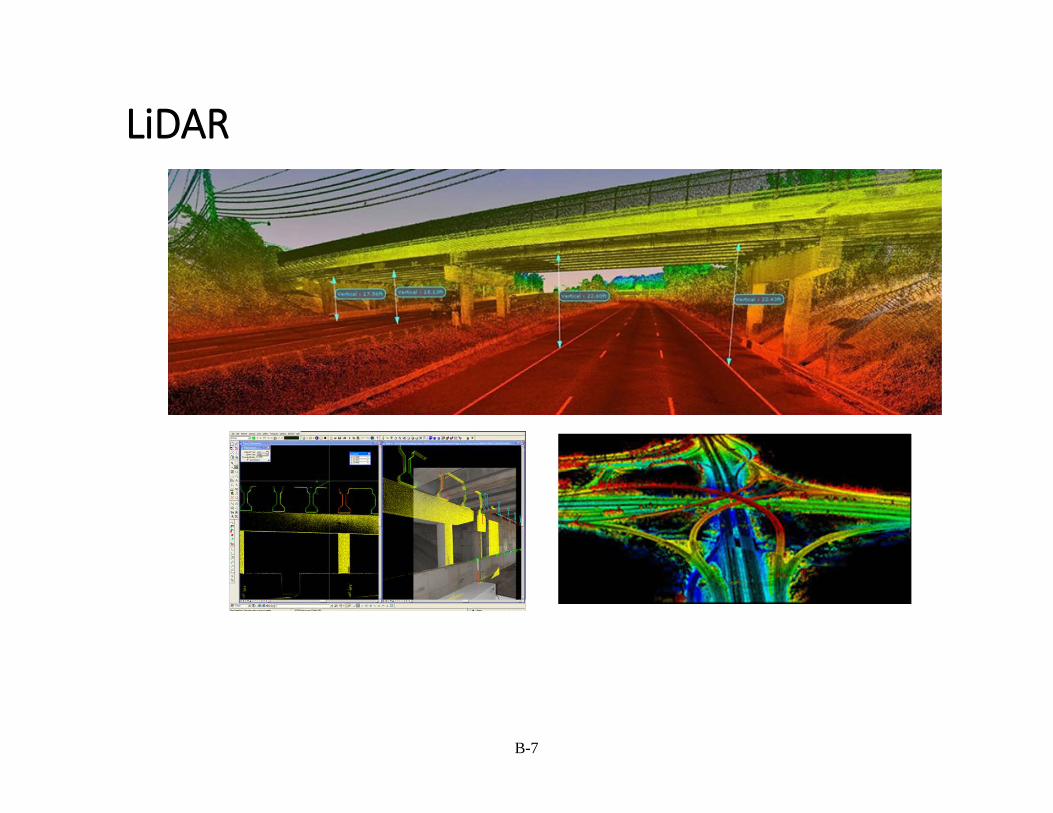
B-7
LiDAR

B-8
Information Modeling
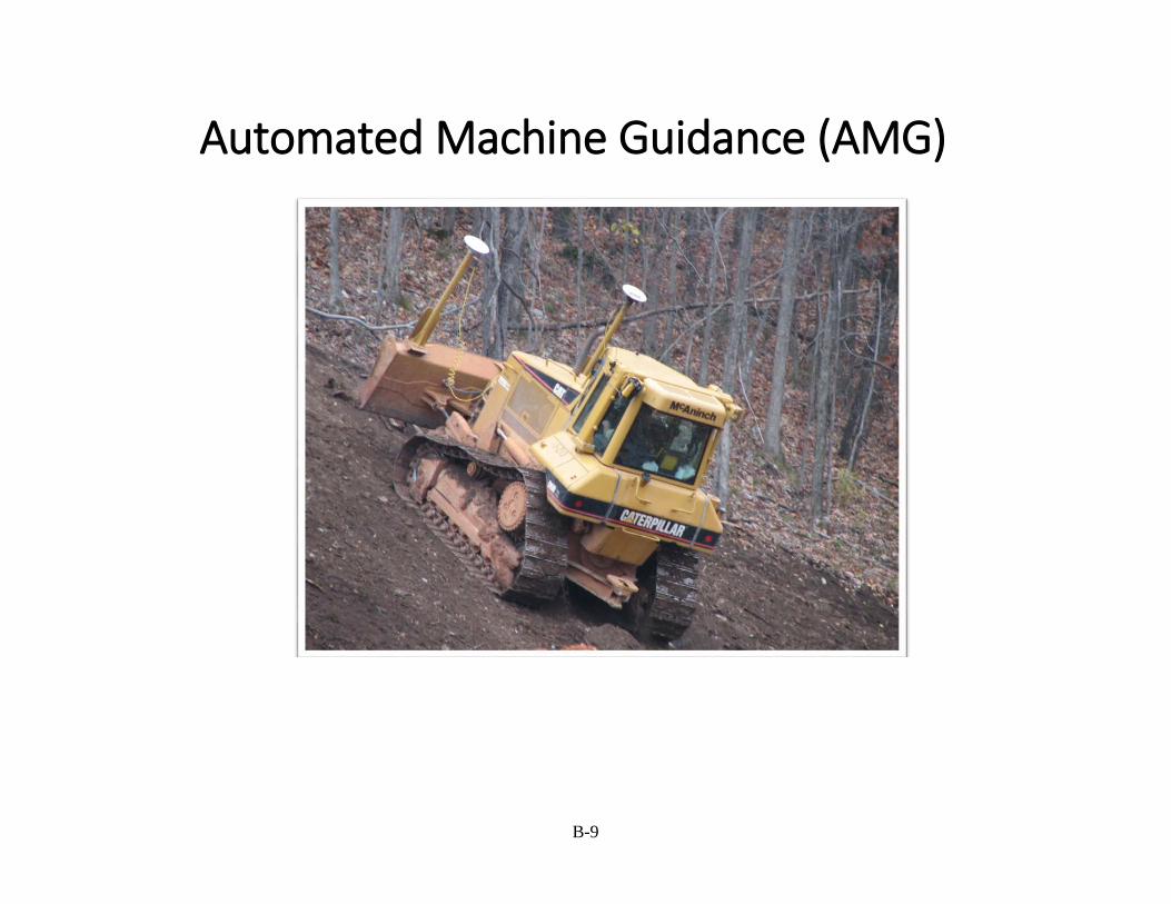
B-9
Automated Machine Guidance (AMG)
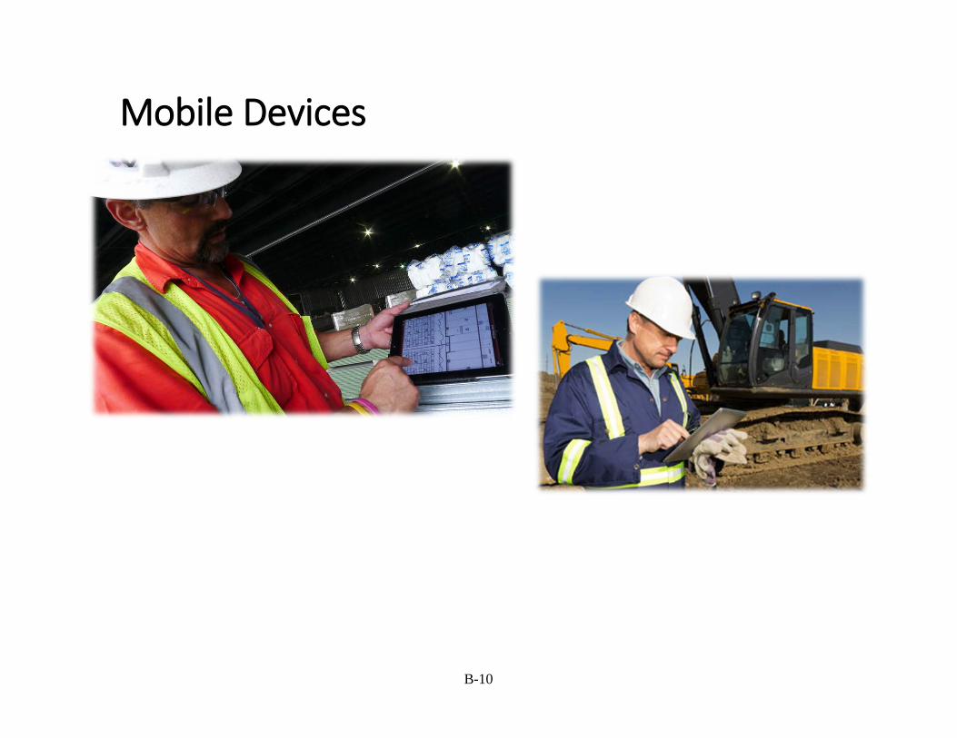
B-10
Mobile Devices
B-11
Discussion on advantages and disadvantages of CIM Technologies

APPENDIX C. SUPER-USERS’ BRAINSTORMING SESSION MINUTES
C-1
Agenda 8:30 – 9:00 Introduction & CIM technologies (e.g., LiDAR, 3D modeling, electronic signatures)
9:00 – 9:45 Discussion on advantages and disadvantages of the CIM technologies presented
9:45 – 10:00 Discussion on any other CIM related technologies
10:00 – 10:15 Coffee Break
10:15 – 10:30 Select top two or three CIM technologies for implementation
10:30 – 11:00 SWOT Analysis for the top one or two CIM Technologies
11:00 – 12:00 Discussion on Barriers & Challenges for Implementation
12:00 Adjourn
Participant List
• Lyndon Robjent – Carver County • Darin Mielke – Carver County • Dan Sullivan – MnDOT • Thomas Ravn – MnDOT • Ronald Dahlquist -MnDOT • Yelda Turkan - ISU • Jennifer Shane - ISU • David Park – SRF Consulting • Dan Symanietz - SRF Consulting • Andy Bosch – SRF Consulting • Eric White – WSB & Associates • Bob Gilman – Kimley-Horn • John Schelkoph – Scott County Public Works Department • Heather Kossila – Kraus Anderson • Brian Levendowski – CAD Technology Center • Dax Kuhfuss – HDR Inc • Frank Ticknor – Washington County
Session Objectives
• Which CIM (Civil Integrated Management) technologies, such as LiDAR, 3D modeling, Automated Machine Guidance (AMG), Electronic Document Management (EDM) Systems, electronic signatures, mobile devices, you are using in your current workflow?
• What are the barriers in your current workflow? How these technologies can help/are helping you?
• What would you like to see change to increase the efficiency in implementing these technologies while decreasing the amount of hard copy construction documents?
• What hinders you from going paperless?
C-2
Project Goal Develop a framework for CIM technology implementation. SWOT Analysis results will be fed into the framework.
Minutes Liability is a big issue for 3D modeling. Consultants do not feel motivated to give their models to contractors. Also, it is challenging, and hard to change the concept of going from drawing to modeling. Liability will go away if the 3D models were the deliverable.
Most consultants are very advanced at modeling. However, the learning curve for new college graduates is very steep. Education, teaching modeling software at college level is important. On the other hand, plan sets are reviewed by senior personnel who have the expertise, so that they can identify whether there is anything missing. But, they’re not familiar with 3D modeling. Financial benefit of moving toward 3D modeling during construction phase needs to be shown. 3D models could be produced at the same level of detail as the drawing sets; no need to make it more detailed. General contractors see the value of 3D modeling. If they could use 3D models legally, they would be more motivated.
Design is based on off traditional surveying (by taking readings every 25-50 ft). Detail level of design is important; perfect plan set is hard to achieve. Preparing cross sections can be eliminated. Instead, provide contractors 3D models, the surface model. Cross sections can be removed from paper plans. Previous survey data (survey data obtained using conventional survey equipment) is not very accurate, which makes modeling difficult.
Traditional DBB Project Delivery is another factor that prevents from going toward 3D modeling, digital data exchange. GC needs to sign a waiver when they receive a model from the designer. CM/GC and DB methods are more collaborative.
Legal aspect: instead of paper plans, cross sections can be provided as PDFs, but, legally, electronic plans are not accepted. How do you make changes to the model? Who is responsible for them? It is easier to keep track of Addendum etc. How easy to make changes, how to identify changes in the model? Changes: It is more difficult and cost smore to build 3D models (up-front costs), but, later on, it is easier to make changes, and to generate cross sections from the 3D model automatically.
Staff structure in companies is another factor that makes 3D modeling implementation more difficult. Companies hire drafters, and after a few years, drafters become supervisors and never do any drafting/modeling again. The expertise gets lost; the new hire needs to be trained. Thus, company structures are one of the biggest hurdles preventing from going paperless.
Technology is not quite there yet. Review software, such as Navisworks, is not very user friendly. In Navisworks environment, it is hard to see some design issues. Instead, one could toggle through the model and look at plan/profile/section views in the model. Cross section navigator is user friendly.
C-3
Resources/up-front costs is another issue that prevents from moving toward 3D/digital project delivery. You need to give your personnel rovers, tablets, etc. to go out to the field and check on the design.
Advantages: If you’re good at 3D modeling, design work is much easier and quicker. Modeling (over drawing) does totally change things; in the end, you have a much better design. Also, it increases the interaction between designer and contractor. But, as long as the waivers for 3D models are there, contractor will not be motivated to go implement or share their 3D model. Revit Software for fabrication in the building industry. Could be used for bridges.
The biggest advantage of using 3D models is the elimination of redundancy. Instead of showing the same thing in 10 different places, labeling it in 5 different places, and handing over all these different plans, deliver a 3D model only, which includes the utilities, materials, etc. Everything is in one location. Requirements for delivering top finish surface, model, DTM, etc., which can be generated from the model easily/automatically. Surface analysis, etc. can be done in the 3D model. Static 3D views and other information can be extracted from the model easily.
Drawback: Software changes very quickly, almost every year. Also, modeling software still has some limitations.
Organizational/Management issue: There is a need for push from the top for change. What senior/experienced reviewers look at when they’re reviewing plans? As a pilot project, instruct the reviewers for items to look for when they’re reviewing. Then, map a new process for 3D models. Also need to determine what is important for a successful project plan from a construction perspective.
About 10 years ago, GSA pushed for BIM implementation in the building industry. Heavy-civil industry should look at the building industry, and possibly push for 3D modeling by making it mandatory for certain type of projects first. More DB projects would also help.
Design review in the building industry is quite different than heavy-civil. Building models are way more complicated, including several complex systems. On the other hand, heavy-civil projects are more complex geometrically.
Interoperability issues: There are challenges with proprietary file formats (Autodesk, Bentley, Trimble). IFC (Industry Foundation Classes), which is a neutral open source file format, is step forward in this regard. 3D models can be exported as an IFC file and imported into Navisworks for model review.
MX, InRoads, and GEOPAK are all Bentley products. MX is used in Europe, and InRoads and GEOPAK in the US. Currently, Bentley is trying to merge all three software together, so that at least there will be no interoperability issues among Bentley software. Will likely take 3 years. Microsoft Connect is a model consolidation software.
Challenges: Data security, IT, network access, cost of the software, liability.
Light rail projects are very collaborative. BOX is a good tool to collaborate. Navisworks files are kept in there so everyone has access to the same model at the same time, all in one place.

C-4
EDM Implementation: would it be beneficial to consultants or the owner? Tools are available. ProjectWise (Bentley), Vault AutoCAD (Autodesk).
Owners not using much and neither are contractors. There is a need for motivation. Commonly used FTP process is not efficient.
Ownership of the model: working on the model at the same time? Changes to the model? And how to combine them? Need a workflow and permission structure set up to be successful.
3D modeling and EDM go together and need to be implemented concurrently.
Network capabilities are another important issue when implementing EDM.
Legal issues: certification. When going from 2D to 3D, engineers’ responsibilities increase. They certify the entire model instead of fewer points. Need to develop a certification process for the models.