Modeling Northern South America and Caribbean climate ... · Caribbean climate using PRECIS and WRF...
12
Guillermo Eduardo Armenta José Daniel Pabón “Weather, Climate, and Society” Research Group Department of Geography, National University of Colombia Modeling Northern South America and Caribbean climate using PRECIS and WRF for climate variability and change studies
Transcript of Modeling Northern South America and Caribbean climate ... · Caribbean climate using PRECIS and WRF...
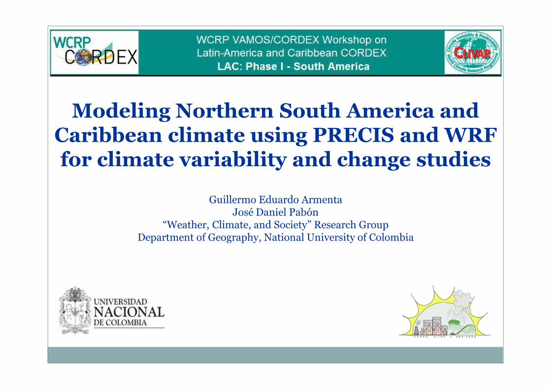
Guillermo Eduardo ArmentaJosé Daniel Pabón
“Weather, Climate, and Society” Research GroupDepartment of Geography, National University of Colombia
Modeling Northern South America and Caribbean climate using PRECIS and WRF for climate variability and change studies
The Research Group “Weather, Climate and Society”
The main objective of the group is to generate knowledge about weather and climate (variability & change), as such as the relationship climate – society. With this purpose the group organizes their activities in the following mainstreams:
¡ Historical Climatology and history of climate (for the Colombian territory)¡ Atmosphere and climate numerical modeling¡ Interaction between different components of the climate system¡ Socioeconomic impacts of climatic variability ¡ Socioeconomic impacts of climate change
For describing and study the atmosphere and climate in the region numerical models have been tested and used. The output from numerical models running have been applied in different ways to explore the regional features of atmosphere, climate variability and change.
Modeling regional atmosphere and climate
The regional community is demanding knowledge (not only data)about atmospheric processes and climate for different science andapplication purposes. To study the atmosphere and climate, theprimary source on which the analysis is based is the recorded data inmeteorological stations. However, in the region data historicallyprovided by observations and measurements are scarce and havemany failures (few series, data sets are incomplete, limited spatialcoverage, heterogeneity). An optional way to solve this problem is thedata generation using numerical models.
To attend demand of the regional atmosphere and climate studies on relative high spatial resolution data, numerical models were applied to simulate the regional processes over the northern South America and South Caribbean.
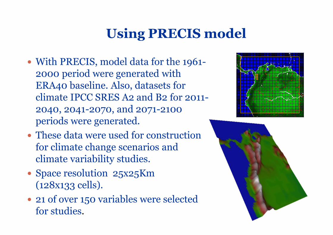
Using PRECIS model
� With PRECIS, model data for the 1961-2000 period were generated with ERA40 baseline. Also, datasets for climate IPCC SRES A2 and B2 for 2011-2040, 2041-2070, and 2071-2100 periods were generated.
� These data were used for construction for climate change scenarios and climate variability studies.
� Space resolution 25x25Km(128x133 cells).
� 21 of over 150 variables were selected for studies.
Mon
thly
surf
ace
win
ddu
ring
the
1961
-200
0 pe
riod
Mon
thly
prec
ipia
tion
durin
gth
e19
61-2
000
perio
d
0,0
100,0
200,0
300,0
400,0
500,0
600,0
700,0
1961
1963
1965
1967
1969
1971
1973
1975
1977
1979
1981
1983
1985
1987
1989
1991
1993
1995
1997
1999
PRECIS
OBSERVAD
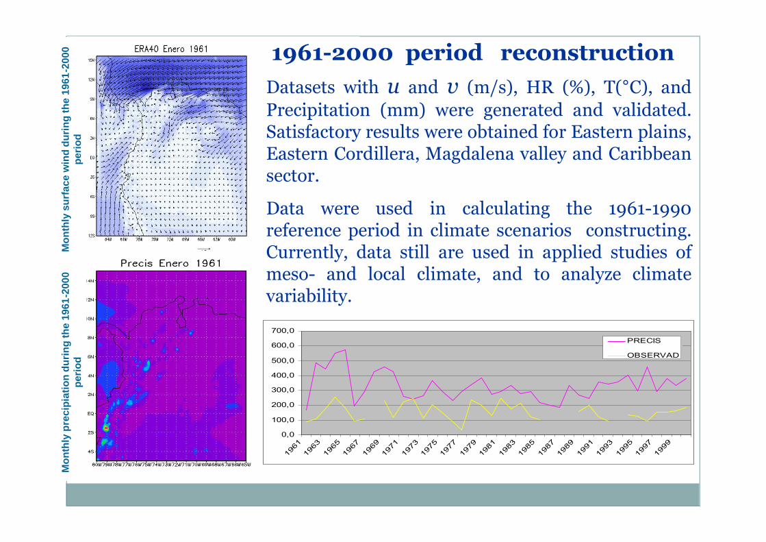
Datasets with u and v (m/s), HR (%), T(°C), andPrecipitation (mm) were generated and validated.Satisfactory results were obtained for Eastern plains,Eastern Cordillera, Magdalena valley and Caribbeansector.
Data were used in calculating the 1961-1990reference period in climate scenarios constructing.Currently, data still are used in applied studies ofmeso- and local climate, and to analyze climatevariability.
1961-2000 period reconstruction
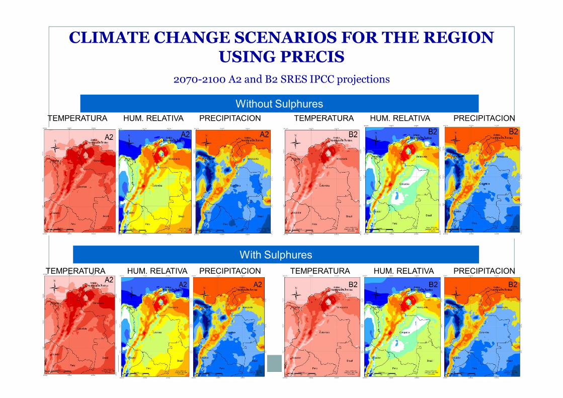
Without Sulphures
With Sulphures
CLIMATE CHANGE SCENARIOS FOR THE REGION USING PRECIS
2070-2100 A2 and B2 SRES IPCC projections
TEMPERATURA TEMPERATURA
TEMPERATURA TEMPERATURA
HUM. RELATIVA
HUM. RELATIVA
HUM. RELATIVA
HUM. RELATIVA
PRECIPITACION PRECIPITACION
PRECIPITACIONPRECIPITACION
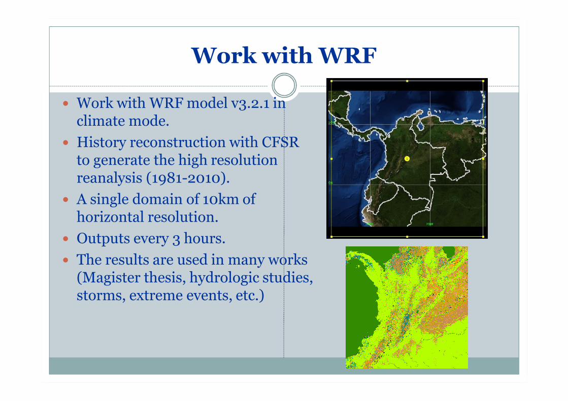
Work with WRF
� Work with WRF model v3.2.1 in climate mode.
� History reconstruction with CFSR to generate the high resolution reanalysis (1981-2010).
� A single domain of 10km of horizontal resolution.
� Outputs every 3 hours.� The results are used in many works
(Magister thesis, hydrologic studies, storms, extreme events, etc.)
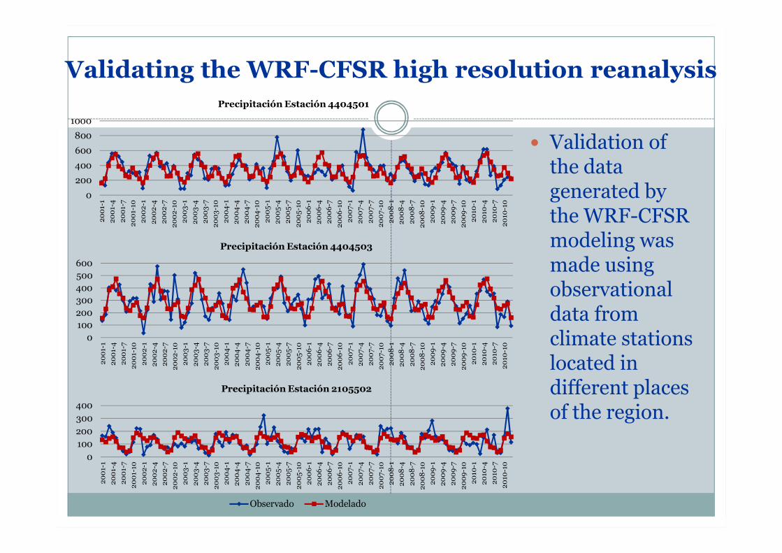
� Validation of the data generated by the WRF-CFSR modeling was made using observational data from climate stations located in different places of the region.
0
200
400
600
800
1000
2001
-120
01-4
2001
-720
01-1
020
02-1
2002
-420
02-7
2002
-10
2003
-120
03-4
2003
-720
03-1
020
04-1
2004
-420
04-7
2004
-10
2005
-120
05-4
2005
-720
05-1
020
06-1
2006
-420
06-7
2006
-10
2007
-120
07-4
2007
-720
07-1
020
08-1
2008
-420
08-7
2008
-10
2009
-120
09-4
2009
-720
09-1
020
10-1
2010
-420
10-7
2010
-10
Precipitación Estación 4404501
0100200300400500600
2001
-120
01-4
2001
-720
01-1
020
02-1
2002
-420
02-7
2002
-10
2003
-120
03-4
2003
-720
03-1
020
04-1
2004
-420
04-7
2004
-10
2005
-120
05-4
2005
-720
05-1
020
06-1
2006
-420
06-7
2006
-10
2007
-120
07-4
2007
-720
07-1
020
08-1
2008
-420
08-7
2008
-10
2009
-120
09-4
2009
-720
09-1
020
10-1
2010
-420
10-7
2010
-10
Precipitación Estación 4404503
0100200300400
2001
-120
01-4
2001
-720
01-1
020
02-1
2002
-420
02-7
2002
-10
2003
-120
03-4
2003
-720
03-1
020
04-1
2004
-420
04-7
2004
-10
2005
-120
05-4
2005
-720
05-1
020
06-1
2006
-420
06-7
2006
-10
2007
-120
07-4
2007
-720
07-1
020
08-1
2008
-420
08-7
2008
-10
2009
-120
09-4
2009
-720
09-1
020
10-1
2010
-420
10-7
2010
-10
Precipitación Estación 2105502
Observado Modelado
Validating the WRF-CFSR high resolution reanalysis
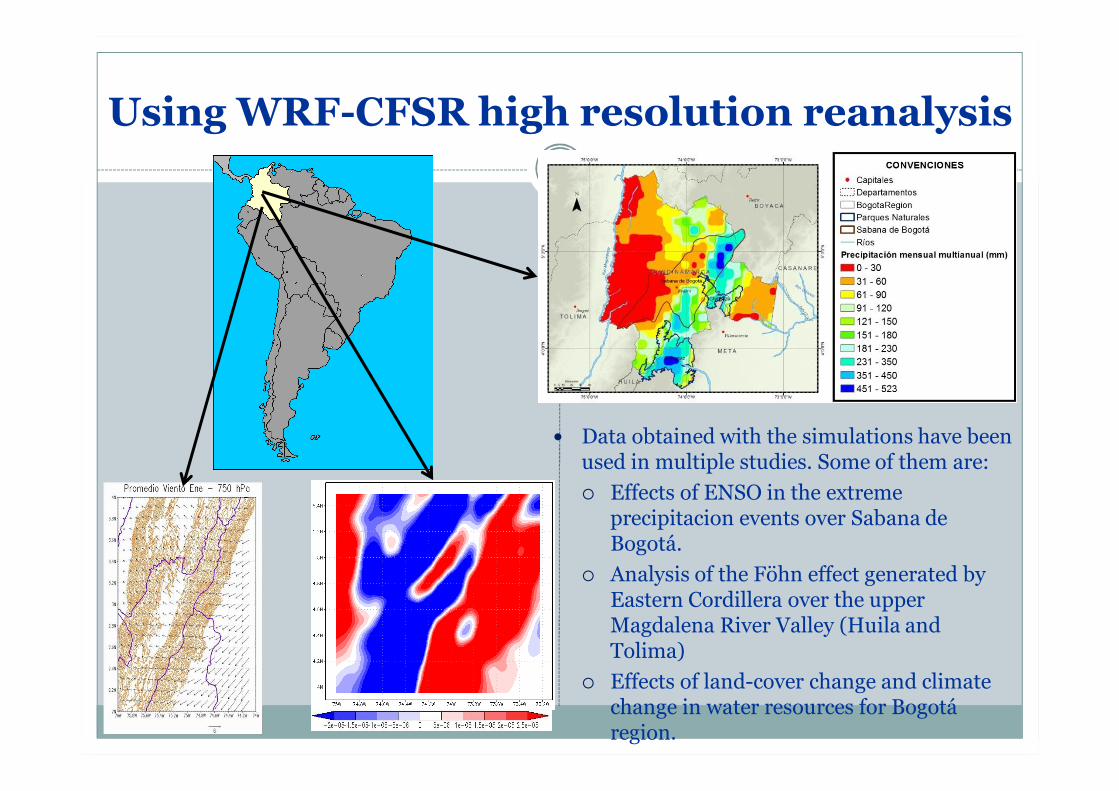
Using WRF-CFSR high resolution reanalysis
� Data obtained with the simulations have been used in multiple studies. Some of them are:¡ Effects of ENSO in the extreme
precipitacion events over Sabana de Bogotá.
¡ Analysis of the Föhn effect generated by Eastern Cordillera over the upper Magdalena River Valley (Huila and Tolima)
¡ Effects of land-cover change and climate change in water resources for Bogotá region.
Future actions
� Use WRF with CMIP5 models to simulate 1981-2010 period.� Validate the results of these simulations with WRF-
CFSR high resolution reanalysis and observational data.
� Generate the regional climate change scenarios using CMIP5 RCP’s.
Future actions
� In 2014, we expect to produce future climate data using PRECIS v2 model with CMIP5 models using historical data from them.� Validate these results with WRF-CFSR high
resolution reanalysis and observational data.� Determine which models are “the best” representing
the climatic variability for Colombia.� Generate Representative Concentration Pathways
(RCP) with CMIP5 models using PRECIS v2.
THANKS