Model Bush Fire Risk Management Plan 2008
78
Annex A to Bush Fire Coordinating Committee Policy No. 1/2008 Bush Fire Risk Management Page 1 of 74 Castlereagh Bush Fire Management Committee Bush Fire Risk Management Plan Castlereagh Bush Fire Management Committee Bush Fire Risk Management Plan
Transcript of Model Bush Fire Risk Management Plan 2008

Annex A to Bush Fire Coordinating Committee
Policy No. 1/2008 Bush Fire Risk Management
Page 1 of 74
Castlereagh Bush Fire Management Committee Bush Fire Risk Management Plan
Castlereagh Bush Fire Management Committee
Bush Fire Risk Management Plan

Annex A to Bush Fire Coordinating Committee
Policy No. 1/2008 Bush Fire Risk Management
Page 2 of 74
Castlereagh Bush Fire Management Committee Bush Fire Risk Management Plan
Glossary 6
Table of Contents
Chapter 1. Introduction 7
1.1 Background 7
1.2 Aim and Objectives 7
1.3 Description of the Castlereagh BFMC Area 8 1.3.1 Location and land tenure 8 1.3.2 Climate and bush fire season 8 1.3.3 Population and demographic information 8 1.3.4 History of bush fire frequency and ignition cause 9
Chapter 2. Identifying and Assessing the Bush Fire Risk 10
2.1 Process 10
2.2 Communication and Consultation 10
2.3 Identifying the Bush Fire Risk 11 2.3.1 Assets 11 2.3.2 Assessing the Bush Fire Risk - Consequence 12 2.3.3 Assessing the Bush Fire Risk - Likelihood 13 2.3.4 Identifying the level of risk 13 2.3.5 Evaluating the Bush Fire Risk 13 2.3.6 Prioritising Treatments 13 2.3.7 Risk Acceptability 13
Chapter 3. Treating the Risk 14
3.1 Bush Fire Management Zones 14
3.2 BFMC Wide Treatments 16
3.3 Asset Specific Treatments 18
3.4 Annual Works Programs 19
3.5 Implementation 20
Chapter 4. Performance Monitoring and Reviewing 21
4.1 Review 21
4.2 Monitoring 21
4.3 Reporting 21
4.4 Performance Measurements 21
Appendix 1. Castlereagh BFMC Participation Strategy 22 1.1 Purpose 22 1.2 Target Audience 23 1.3 Issues to be Communicated 23 1.4 Methods of Communication 24 1.5 Implementation 26
Appendix 2. Asset Register (in order of priority) 29
Appendix 3. Treatment Register (in order of priority) 38
Appendix 4. Castlereagh BFMC Fire Trail Register 51

Annex A to Bush Fire Coordinating Committee
Policy No. 1/2008 Bush Fire Risk Management
Page 3 of 74
Castlereagh Bush Fire Management Committee Bush Fire Risk Management Plan
Appendix 5. Neighbour Safer Places 72
Appendix 6. Maps 1- 4 74 List of Tables Table 1.1 Land tenure 8Table 3.1 Bush Fire Management Zones: Purpose, objectives and characteristics 15Table 3.2 Asset specific treatments used in the Castlereagh BFMC area 18Table 3.3 Fire Thresholds for Vegetation Categories 19 List of Figures Figure 2.1 Overview of the risk assessment process ..................................................................................... 10


Annex A to Bush Fire Coordinating Committee
Policy No. 1/2008 Bush Fire Risk Management
Page 5 of 74
Castlereagh Bush Fire Management Committee Bush Fire Risk Management Plan
Amendment List
Amendment Entered Number Date Signature Date

Annex A to Bush Fire Coordinating Committee
Policy No. 1/2008 Bush Fire Risk Management
Page 6 of 74
Castlereagh Bush Fire Management Committee Bush Fire Risk Management Plan
Glossary Assets: anything valued by the community which includes houses, crops, heritage buildings and places, infrastructure, the environment, businesses, and forests, that may be at risk from bush fire. Bush Fire: a general term used to describe fire in vegetation, includes grass fire. Bush Fire Hazard: the potential severity of a bush fire, which is determined by fuel load, fuel arrangement and topography under a given climatic condition. Bush Fire Risk: the chance of a bush fire igniting, spreading and causing damage to the community or the assets they value. Bush Fire Risk Management: a systematic process that provides a range of treatments which contribute to the well being of communities and the environment, which suffer the adverse effects of wildfire/bush fire. Bush Fire Threat: potential bush fire exposure of an asset due to the proximity and type of a hazard and the slope on which the hazard is situated. Consequence: outcome or impact of a bush fire event. Fire Fighting Authorities: the NSW Rural Fire Service, NSW Fire Brigades, the National Parks and Wildlife Service and Forests NSW. Likelihood: the chance of a bush fire igniting and spreading. Major Bush Fire: a bush fire which requires the attendance of multiple brigades, or causes damage to property or injury to one or more persons. Display area: geographic area determined by the Bush Fire Management Committee which is used to provide a suitable area and scale for community participation and mapping display purposes. Recovery costs: the capacity of an asset to recover from the impacts of a bush fire. Risk Acceptance: an informed decision to accept the consequences and the likelihood of a particular risk. Risk Analysis: a systematic process to understand the nature of and to deduce the level of risk. Risk Assessment: the overall process of risk identification, risk analysis and risk evaluation. Risk Identification: the process of determining what, where, when, why, and how something could happen. Risk Treatment: the process of selection and implementation of measures to modify risk. Vulnerability: the susceptibility of an asset to the impacts of bush fire.

Annex A to Bush Fire Coordinating Committee
Policy No. 1/2008 Bush Fire Risk Management
Page 7 of 74
Castlereagh Bush Fire Management Committee Bush Fire Risk Management Plan
Chapter 1. Introduction
1.1 Background Under the Rural Fires Act 1997 the Bush Fire Coordinating Committee (BFCC) must constitute a Bush Fire Management Committee (BFMC) for each area in the State, which is subject to the risk of bush fires. Each BFMC is required to prepare and submit to the BFCC a Bush Fire Risk Management Plan (BFRMP). A BFRMP is a strategic document that identifies community assets at risk and sets out a five-year program of coordinated multi-agency treatments to reduce the risk of bush fire to the assets. Treatments may include such things as hazard reduction burning, grazing, community education, fire trail maintenance and establishing community fireguard groups. Annual programs to implement the treatments identified in this plan will be undertaken by the relevant land managers and fire fighting authorities. In exercising its functions under the Rural Fires Act 1997, including the preparation of a bush fire risk management plan, the Castlereagh BFMC is required to have regard to the principles of ecologically sustainable development (ESD). This document and the accompanying maps together form the BFRMP for the Castlereagh BFMC area. This BFRMP has been prepared by the Castlereagh BFMC and covers both public and private lands. This BFRMP must be reviewed and updated within each successive five-year period from the constitution of the BFMC. The BFCC recognises that climate change has the potential to increase bush fire risk. The risk assessment process applied in this BFRMP is based on current climatic conditions. The BFCC will monitor information on climate change and will modify the process when necessary.
1.2 Aim and Objectives The aim of this BFRMP is to minimise the risk of adverse impact of bush fires on life, property and the environment. The objectives of this BFRMP are to:
• reduce the number of human-induced bush fire ignitions that cause damage to life, property and the environment;
• manage fuel to reduce the rate of spread and intensity of bush fires, while minimising environmental/ecological impacts;
• reduce the community’s vulnerability to bush fires by improving its preparedness; and
• effectively contain fires with a potential to cause damage to life, property and the environment.

Annex A to Bush Fire Coordinating Committee
Policy No. 1/2008 Bush Fire Risk Management
Page 8 of 74
Castlereagh Bush Fire Management Committee Bush Fire Risk Management Plan
1.3 Description of the Castlereagh BFMC Area
1.3.1 Location and land tenure The Castlereagh BFMC area is located in the Upper Central West Slopes and Plains and Lower North West Slopes and Plains of New South Wales and includes the Local Government Area of Gilgandra and Warrumbungle. The area covered by the Castlereagh BFMC is 17,888.5 sq. km and includes the land tenures outlined in Table 1.1.
Land Manager % of BFMC area National Parks & Wildlife Service 9.94 Forests NSW 3.39 Department of Lands 1.89 Local Government 0.25 Private 84.03 All other 0.50
Table 1.1 Land Tenure
1.3.2 Climate and bush fire season The typical / average climate in the Castlereagh BFMC area does not vary much across the BFMC area with warm to hot temperatures with winds normally from the western sector during the summer with cool to cold dryer winter period. Summer rainfall is generally in the form of severe electrical storms caused by cold fronts moving in from the west. Dry lighting storms can also occur during dryer seasonal conditions across much of the BFMC area. The bush fire season generally runs from October to March. Mid November to end of December is typically the worst months for large fires. In the south fire activity can continue until February – March during dryer years.
1.3.3 Population and demographic information The population of the Castlereagh BFMC area is approximately 14,330 people. The major population centres are Coonabarabran, Coolah and Gilgandra. The following issues have been identified within the Castlereagh BFMC area as potentially impacting on the ability of certain sections of the community to prepare themselves for bush fire:
1. Large numbers of absentee landowners in remote areas 2. Ageing population, particularly in rural areas 3. An increase in commuting workers leaving properties in pursuit of work. 4. An increase in rural residential subdivisions in fire prone areas.

Annex A to Bush Fire Coordinating Committee
Policy No. 1/2008 Bush Fire Risk Management
Page 9 of 74
Castlereagh Bush Fire Management Committee Bush Fire Risk Management Plan
1.3.4 History of bush fire frequency and ignition cause The Castlereagh BFMC area has on average 80 bush fires per year, of which 3 on average can be considered to be major fires.
The main sources of ignition in the Castlereagh BFMC area are;
1. lightning, 2. escape from legal burns, 3. farm machinery, 4. incendiaries and 5. campfires.
Lightning activity in the area is mainly associated with spring and summer electrical storms (November through to the end of March). These storms are usually accompanied by heavy rainfall, however, periodically they happen with little or no rain causing the possibility of ignition where strikes occur. Generally these storms follow ironstone outcrops, Warrumbungle Mountains, Pilliga scrub and dry sclerophyll forests within the Castlereagh area. Most escapes from legal burns occur mainly in the rural farming and grazing managed lands spread through the whole of the Castlereagh BFMC area and rural subdivisions or rural/urban interface areas around the major towns. Farm machinery and mechanical ignitions usually happen during the summer grain harvest period from mid November to the end of January and are generally the result of poor maintenance of machinery. During the summer school holiday periods the possibility of incendiaries can increase.

Annex A to Bush Fire Coordinating Committee
Policy No. 1/2008 Bush Fire Risk Management
Page 10 of 74
Castlereagh Bush Fire Management Committee Bush Fire Risk Management Plan
Chapter 2. Identifying and Assessing the Bush Fire Risk
2.1 Process The Australia/New Zealand Standard AS/NZS 4360: 2004 Risk Management was used as the basis for the risk assessment process. See Figure 2.1 for the steps involved. For a detailed description of the process undertaken see the Bush Fire Risk Management Planning Guidelines for Bush Fire Management Committees on the RFS website: www.rfs.nsw.gov.au.
Figure 2.1 Overview of the risk assessment process
2.2 Communication and Consultation Community participation is an integral part of risk management. The Community Participation Strategy involved developing and implementing a process to address the needs, issues and concerns of stakeholders within the BFMC area in regards to the BFRMP. See Appendix 1 for the Community Participation Strategy used by the Castlereagh BFMC in preparing this BFRMP.
Establish the Context
Identify risks
Analyse risks
Evaluate risks
Treat risks
Mon
itor a
nd re
view
Com
mun
icat
e an
d co
nsul
t
Ris
k A
sses
smen
t

Annex A to Bush Fire Coordinating Committee
Policy No. 1/2008 Bush Fire Risk Management
Page 11 of 74
Castlereagh Bush Fire Management Committee Bush Fire Risk Management Plan
2.3 Identifying the Bush Fire Risk Identifying the level of bush fire risk firstly involved identifying important community assets considered to be at risk from bush fire in the Castlereagh BFMC area, and then assessing the likelihood and consequence ratings.
2.3.1 Assets BFMC members and the community, including RFS volunteers, identified assets within the Castlereagh BFMC that they believed were at risk of bush fire. The assets were divided into four asset types:
• Residential areas including urban bushland interface areas and rural properties;
Human settlement
• Special Fire Protection areas including schools, hospitals, nursing homes, and tourist facilities; and
• Other human settlement areas including commercial and industrial areas where distinct from major towns.
• Agricultural; e.g. major silos, regional saleyards, cropping/grazing land;
Economic
• Commercial/industrial e.g. major industries, waste treatment plants, sawmills; • Infrastructure e.g. large power lines, gas and oil pipelines, railway lines, electricity
substations, communication facilities; • Tourist and recreational e.g. tourist sites and facilities, resorts, retreats; • Mines; • Commercial forests e.g. pine plantations, eucalypt plantations and commercial
native forests; and • Drinking water catchments.
• Threatened species, populations and ecological communities and Ramsar wetlands;
Environmental
• Locally important species and ecological communities, such as species and ecological communities especially sensitive to fire.

Annex A to Bush Fire Coordinating Committee
Policy No. 1/2008 Bush Fire Risk Management
Page 12 of 74
Castlereagh Bush Fire Management Committee Bush Fire Risk Management Plan
• Aboriginal significance – Aboriginal places and items of significance;
Cultural
• Non-indigenous heritage – places and items arising from the early occupation of NSW by European or other non-indigenous settlers; and
• Other cultural assets – community halls, clubs and recreational facilities. See Appendix 2 for the full list of assets identified in the Castlereagh BFMC area. See maps 2 - 4 for the location of assets to be treated under this BFRMP.
2.3.2 Assessing the Bush Fire Risk - Consequence Once the assets were identified, the consequence of a bush fire impacting on these assets was assessed. See Appendix 2 for the consequence ratings assigned to each asset identified in the Castlereagh BFMC area. The different asset types had different assessment processes used to determine the consequence. These processes are identified below.
A potential fire behaviour model using vegetation type, slope and separation distance was used to produce a threat rating for human settlement assets. The vulnerability of the asset to a bush fire was also assessed and a rating assigned. These ratings were then used to assess the consequence of a bush fire impacting upon a human settlement asset.
Human settlement
Special Fire Protection (SFP) assets were considered inherently more vulnerable to bush fire due to mobility capacity, knowledge or other issues relating to their inhabitants, (e.g. the elderly, infirm, children or tourists) and therefore stricter requirements for vulnerability assessment and rating were applied.
The level of economic impact e.g. local, regional or state, as well as the economic recovery costs (how long and complicated a financial recovery will be) of the asset were identified. These ratings were used to assess the consequence of a bush fire impacting upon an economic asset.
Economic
Environmental assets with known minimum fire threshold were assessed to determine if they were at risk of a bush fire within the 5 year life of the BFRMP using fire history data. Those environmental assets which were within or above the fire threshold were not assessed in the BFRMP, as the negative impact of a fire within the 5 year period was determined as being low and may even be of benefit to the asset and surrounding habitat.
Environmental
The vulnerability of an environmental asset was determined by its conservation status and its geographic extent (distribution across the landscape). Vulnerability and potential impact

Annex A to Bush Fire Coordinating Committee
Policy No. 1/2008 Bush Fire Risk Management
Page 13 of 74
Castlereagh Bush Fire Management Committee Bush Fire Risk Management Plan
of bush fire were used to assess the consequence of a bush fire impacting upon an environmental asset.
For non-indigenous historical, Aboriginal and other cultural assets a potential fire behaviour model using fuel load, slope and proximity was used to produce a threat rating. The physical vulnerability of the asset to a bush fire was also assessed. These ratings were then used to assess the consequence of a bush fire impacting upon a cultural asset.
Cultural
2.3.3 Assessing the Bush Fire Risk - Likelihood For all asset types the likelihood of a bush fire occurring was assessed. This involves considering fire history, including ignition cause and patterns, known fire paths, access, containment potential and potential fire run (size of the vegetated area). See Appendix 2 for the likelihood ratings assigned to each asset identified in the Castlereagh BFMC area.
2.3.4 Identifying the level of risk The consequence and likelihood ratings were then used to identify the level of risk. See Appendix 2 for the risk ratings assigned to each asset identified in the Castlereagh BFMC area.
2.3.5 Evaluating the Bush Fire Risk Once the risk ratings for each asset were identified, they were evaluated to:
a) confirm that risk levels identified in the risk analysis process are appropriate and reflect the relative seriousness of the bush fire risk;
b) identify which assets require treatments; and c) identify treatment priorities.
2.3.6 Prioritising Treatments No organisation has limitless resources to deal with adverse risk. It is therefore necessary to define priorities. The bush fire risk ratings determined were used to prioritise the risk treatments, i.e. areas of extreme risk were considered first for treatment, then very high, then high then medium then low. It was also necessary to prioritise within the risk levels i.e. determining which of the high risks was the most serious. This was done on the basis of the consequence and likelihood ratings.
2.3.7 Risk Acceptability Risks below a certain level were assessed as not requiring treatment within the life of this plan. This is due to a combination of risk priority and capacity to undertake the works. Within the Castlereagh BFMC area the level of acceptability is high. Areas of medium or low risk are likely to be managed by routine procedures and so do not require a specific application of resources.

Annex A to Bush Fire Coordinating Committee
Policy No. 1/2008 Bush Fire Risk Management
Page 14 of 74
Castlereagh Bush Fire Management Committee Bush Fire Risk Management Plan
Chapter 3. Treating the Risk
3.1 Bush Fire Management Zones Bush Fire Management Zones were identified within the Castlereagh BFMC area and mapped (see maps 2 - 4). These zones identify the fire management intent for a specific area. See Table 3.1 for descriptions of the zones and their purposes. The four categories of Bush Fire Management Zones are:
• Asset Protection Zone (APZ); • Strategic Fire Advantage Zone (SFAZ); • Land Management Zone (LMZ); and • Fire Exclusion Zone (FEZ).
Note:
Some Asset Protection Zones (APZ) within the Castlereagh BFMC are not mapped.
Asset Protection Zones are determined in the Bush Fire Environmental Assessment Code (the Code), and applicable widths for the protection of assets (residential buildings, special fire protection buildings and major buildings) as specified within the Code can be applied to protect assets where these Asset Protection Zones have not been specifically identified. For example: Isolated dwellings and major buildings. Where Strategic Fire Advantage Zones (SFAZ) adjoins assets, for the purposes of the Castlereagh BFMC Risk Plan, an Asset Protection Zone (APZ) can be deemed to apply to the maximum permissible area under the Code. Where Strategic Fire Advantage Zone (SFAZ) works are prescribed adjoining assets, Asset Protection Zone (APZ) works can be undertaken to complement the Strategic Fire Advantage Zone works.

Annex A to Bush Fire Coordinating Committee
Policy No. 1/2008 Bush Fire Risk Management
Page 15 of 74
Castlereagh Bush Fire Management Committee Bush Fire Risk Management Plan
Zone Purpose Suppression Objective(s) Zone characteristics Asset Protection Zone
To protect human life, property and highly valued public assets and values.
To enable the safe use of Direct Attack suppression strategies within the zone. To minimise bush fire impacts on undefended assets.
As per RFS document Standards for Asset Protection Zones.
Strategic Fire Advantage Zone
To provide strategic areas of fire protection advantage which will reduce the speed and intensity of bush fires, and reduce the potential for spot fire development; To aid containment of wildfires to existing management boundaries.
To improve the likelihood and safe use of: Parallel Attack suppression strategies within the zone. and/or Indirect Attack (back burning) in high to very high fire weather conditions within the zone. To reduce the likelihood of: Crown fire development within the zone. and/or Spot fire ignition potential from the zone
Zone width related to suppression objectives and dependant upon: • Topography • Aspect • Spotting propensity • Location of adjacent
firebreaks • Mosaic pattern of
treatment Assess Overall Fuel Hazard (OFH) once vegetation communities reach minimum fire thresholds within this plan. Management practices should aim to achieve mosaic fuel reduction patterns so that the majority of the SFAZ has an OFH of less than high.
Land Management Zone
To meet relevant land management objectives in areas where APZs or SFAZs are not appropriate.
As per the land management and fire protection objectives of the responsible land management agency. To reduce the likelihood of spread of fires. To undertake mosaic burning
As appropriate to achieve land management e.g. heritage and/or fire protection e.g. broad scale mosaic burning objectives.
Fire Exclusion Zone
To exclude bush fires.
N/A Variable dependant on size of fire sensitive area requiring protection.
Table 3.1 Bush Fire Management Zones: Purpose, objectives and characteristics NB: OFH refers the Overall Fuel Hazard Guide as described in the document published by (Dept. of Sustainability and Environment 3rd edition. 1999 & NPWS version); State-wide procedures for assessment of fuel hazard will be developed in conjunction with the BFCC. Note:
All areas that are not mapped or described as APZs or SFAZs are considered as LMZs.

Annex A to Bush Fire Coordinating Committee
Policy No. 1/2008 Bush Fire Risk Management
Page 16 of 74
Castlereagh Bush Fire Management Committee Bush Fire Risk Management Plan
For the purpose of the Bush Fire Environmental Assessment Code:
1. Plantations that are approved under the Plantations & Reafforestation Act 1999 after closure of the public exhibition period for this BFRMP are considered to be identified in this BFRMP; and
2. Retained vegetation within the aforementioned plantations is considered to be a Strategic Fire Advantage Zone identified in the text of this BFRMP as long as it meets the suppression objectives for SFAZs included in the BFRMP, and is not mapped or otherwise described as a Fire Exclusion Zone in the BFRMP.
3.2 BFMC Wide Treatments BFMC wide treatments are activities which reduce the overall bush fire risk within the BFMC area and are undertaken on an ongoing basis as part of normal business. These treatments are not linked to specific assets in the BFRMP, rather they are applied across all or part of the BFMC area as designated by legislation or agency policy. BFMC wide treatments include the following:
• Reviewing the bush fire prone land map These maps identify bush fire prone land and are used to trigger whether a development application is assessed using Planning for Bush Fire Protection1
• Ensuring developments in bush fire prone land comply with Planning for Bush Fire Protection
.
This assessment process requires new applications for development to include bush fire protection measures.
• Using the Local Environment Plan/s (LEPs) to control developments in areas with a bush fire risk LEPs can be used to exclude development in extreme bush fire risk areas or where bush fire protection measures cannot be incorporated.
• Varying the standard bush fire danger period as required In years where the weather is particularly adverse the bush fire danger period may be brought in early or extended. This is assessed every year by the BFMC.
• Requiring permits during the bush fire danger period In the bush fire danger period a fire safety permit is required to light a fire in the open. Permits specify conditions such as fire fighting equipment that must be on site, or restrict burns based on weather conditions.
1 NSW Rural Fire Service 2006 Planning for Bush Fire Protection: A guide for councils, planners, fire authorities and developers.

Annex A to Bush Fire Coordinating Committee
Policy No. 1/2008 Bush Fire Risk Management
Page 17 of 74
Castlereagh Bush Fire Management Committee Bush Fire Risk Management Plan
• Prosecution of arsonists/offenders Under the Rural Fires Act 1997 persons may be prosecuted for breaching the conditions on a fire permit, lighting a fire during a Total Fire Ban, allowing fire to escape their property, or other breaches of the Act.
• Investigation of bush fire cause All bush fires which do not have a known cause are investigated to identify how they started.
• Normal fire suppression activities Responding to bush fire is a normal business activity for the fire fighting authorities.
• Assessing and managing compliance with strategic fire fighting resource allocation provisions Strategic fire fighting resource allocation provisions is the process used to identify the number of stations, brigades and appliances required in an area, and considers members, training, assets and hazards.
• Preparation of a S52 Operations Coordination Plan The Operations Coordination Plan is prepared biannually and sets out how coordinated fire fighting will occur. It includes specific operational restrictions on fire fighting techniques in certain areas, where fires will be managed from, and how agencies involved can communicate during operations.
• Fire Management Plans or Plans of Management Some land management agencies have developed fire management plans or plans of management with specific fire or fuel management strategies, for example a Forests NSW Regional Fuel Management Risk Plan, a NPWS Fire Management Strategy. These publicly exhibited plans form the basis for operational fire planning on public parks, reserves and forests.
• Bush Fire Hazard Complaints If someone is concerned about possible bush fire hazards on a neighbouring property or any other land, then this can be reported to the RFS Commissioner or their local RFS Fire Control Centre. The complaint will be investigated and may result in a notice being issued to the landowner or manager to reduce the hazard.

Annex A to Bush Fire Coordinating Committee
Policy No. 1/2008 Bush Fire Risk Management
Page 18 of 74
Castlereagh Bush Fire Management Committee Bush Fire Risk Management Plan
3.3 Asset Specific Treatments There are five broad strategy groups available to treat the bush fire risk to assets identified in the BFRMP. The types of asset specific treatments in each strategy group used in the Castlereagh BFMC area are listed below. A full list of the treatment strategies in the Castlereagh BFMC area are in Appendix 3.
Strategy Targeted treatments used in the Castlereagh BFMC area Ignition Management
Improve fire permit management. Investigate fire cause and origin. Restrict or manage public access.
Hazard Reduction
Undertake fuel management activities including mechanical, burning, grazing and chemical treatments.
Community Education
To undertake fuel management activities aimed at increasing levels of community resilience and preparedness.
Property Planning
Maintain Fire Trails. Improve access for emergency and fire fighting vehicles. Apply Planning for Bush Fire Protection.
Preparedness Review emergency fire relocation plans. Undertake routine maintenance of fire trails. Prepare and maintain DECCW RFMS for National Parks & Reserves
Table 3.2 Asset specific treatments used in the Castlereagh BFMC area

Annex A to Bush Fire Coordinating Committee
Policy No. 1/2008 Bush Fire Risk Management
Page 19 of 74
Castlereagh Bush Fire Management Committee Bush Fire Risk Management Plan
Vegetation formation Minimum SFAZ Threshold
Minimum LMZ Threshold
Maximum Threshold Notes
Rainforest NA NA NA Fire should be avoided.
Alpine complex NA NA NA Fire should be avoided.
Wet Sclerophyll forest (shrubby subformation) 25 30 60 Crown fires should be avoided in
the lower end of the interval range. Wet Sclerophyll forest (grassy subformation) 10 15 50 Crown fires should be avoided in
the lower end of the interval range.
Grassy woodland 5 8 40
Minimum interval of 10 years should apply in the southern Tablelands area. Occasional intervals greater then 15 years may be desirable.
Grassland 2 3 10
Occasional intervals greater than 7 years should be included in coastal areas. There was insufficient data to give a maximum interval; available evidence indicates maximum intervals should be approximately 10 years.
Dry sclerophyll forest (shrub/grass subformation)
5 8 50 Occasional intervals greater than 25 years may be desirable.
Dry sclerophyll forest (shrub subformation) 7 10 30 Occasional intervals greater than 25
years may be desirable.
Heathlands 7 10 30 Occasional intervals greater than 20 years may be desirable.
Freshwater wetlands 6 10 35 Occasional intervals greater than 30 years may be desirable.
Forested wetlands 7 10 35 Some intervals greater than 20 years may be desirable.
Saline wetlands NA NA NA Fire should be avoided.
Semi-arid woodlands (grassy subformation) 6 9 No max Not enough data for a maximum fire
interval. Semi-arid woodlands (shrubby subformation) 10 15 No Max Not enough data for a maximum fire
interval. Arid shrublands (chenopod subformation NA NA NA Fire should be avoided.
Arid shrublands (acacia subformation) 10 15 No Max Not enough data for a maximum fire
interval.
Table 3.3 Fire Thresholds for Vegetation Categories
3.4 Annual Works Programs The land management agencies and fire fighting authorities responsible for implementing the treatments identified in this plan will include those treatments in their annual works programs detailing how, when, and where the required activities will be undertaken.

Annex A to Bush Fire Coordinating Committee
Policy No. 1/2008 Bush Fire Risk Management
Page 20 of 74
Castlereagh Bush Fire Management Committee Bush Fire Risk Management Plan
3.5 Implementation When the treatments identified in this BFRMP are implemented there are a number of issues that need to be considered by the responsible agency including environmental assessments and approvals, smoke management and prescribed burn plans.
In the Castlereagh BFMC area the issuing of permits and hazard reduction burning is not permitted between the 27th December to 31st December or on gazetted public holidays during the Bush Fire Danger Period (BFDP).
Local fire safety permit issuing and hazard reduction burning exclusion periods
Notice of intention to maintain a fire In the Castlereagh BFMC area any person maintaining a fire in the open except for the purpose of cooking or heating must give at least 24 hours notice of their intention to light a fire to all adjacent landholders and to the local NSW Rural Fire Control Centre or NSW Fire Brigade Station.

Annex A to Bush Fire Coordinating Committee
Policy No. 1/2008 Bush Fire Risk Management
Page 21 of 74
Castlereagh Bush Fire Management Committee Bush Fire Risk Management Plan
Chapter 4. Performance Monitoring and Reviewing
4.1 Review This BFRMP must be reviewed and updated within each successive five-year period from the constitution of the BFMC. The Castlereagh BFMC will also review this plan as necessary to account for any changes in context or risk. This may be triggered by a range of circumstances, including but not limited to:
• changes to the BFMC area, organisational responsibilities or legislation;
• changes to the bush fire risk in the area; or
• following a major fire event.
4.2 Monitoring The BFMC is required to monitor progress towards the completion of treatment works listed in the BFRMP, and the timeliness of the works.
4.3 Reporting The BFMC is required to report annually to the BFCC on its progress in implementing the bush fire risk management activities identified in this plan.
4.4 Performance Measurements State wide performance measurements which are linked to the BFRMP have been identified by the BFCC. All BFMCs must use these to monitor and report on their success in reducing the bush fire risk in their BFMC area.

Annex A to Bush Fire Coordinating Committee
Policy No. 1/2008 Bush Fire Risk Management
Page 22 of 74
Castlereagh Bush Fire Management Committee Bush Fire Risk Management Plan
Appendices
Appendix 1. Castlereagh BFMC Participation Strategy
1.1 Purpose
• To ensure that specific and targeted communication occurs between the BFMC and the community throughout the development of Bush Fire Risk Management Plans (BFRMP).
• To ensure prominent stakeholders do not make judgements of the acceptability of a risk based on their own perception of risk.
• To provide greater opportunity for local brigades, land holders and other stakeholders to have input into the bush fire risk management process.
• To determine the concerns of the community regarding bush fire risks within the community.
• To ensure that the community’s perceptions of risk, as well as their perceptions of benefits, be identified, understood, documented and addressed in the BFRMP.
• To improve community confidence in bush fire risk management across the landscape and provide the community with a sense of ownership of the BFRMP.
• Educate the community regarding bush fire risk management in the area so that they can contribute towards risk reduction.

Annex A to Bush Fire Coordinating Committee
Policy No. 1/2008 Bush Fire Risk Management
Page 23 of 74
Castlereagh Bush Fire Management Committee Bush Fire Risk Management Plan
1.2 Target Audience Potential organisations and individuals to be targeted are identified in the following table. Target Audience Description Community People who live or have assets within the
Gilgandra and Warrumbungle Shire Councils LGAs, particularly those potentially effected by bush fire
Community groups Formal and informal networks operating within the community such as:
- Environmental groups- Landcare, Nature Conservation Council, Local Flora Groups etc
- Service clubs - Community action groups - Chamber of commerce and
industry - Schools - Local Aboriginal land councils - Farming groups
Existing BFMC subcommittees The formal and informal networks operating within the existing bush fire risk management structure
Local government networks Local government/community. Formal and informal networks based on the local government council
Agency networks Formal and informal networks within and between emergency service agencies, functional area agencies and the community
RFS Brigades and Community Fireguard groups
Formal volunteer groups with an active interest in fire management.
Table 1.1 Target audiences
1.3 Issues to be Communicated There are key considerations that will affect the community and should be actively discussed with all stakeholders. They are:
• Identification of risks- where are the hazards and assets • Determination the likelihood/consequence • Prioritisation of risks • Risk treatment strategies • Community Engagement (Education)

Annex A to Bush Fire Coordinating Committee
Policy No. 1/2008 Bush Fire Risk Management
Page 24 of 74
Castlereagh Bush Fire Management Committee Bush Fire Risk Management Plan
1.4 Methods of Communication
Communicative activity
Target Description Main resources required
Community meetings Coonabarabran Coolah Gilgandra
Initiating community meeting, facilitating open forums, semi structured discussion
presenter/facilitator - briefing PowerPoint presentation - meeting venue - electronic & paper maps
Pre-planned meetings Rural Fire Service Brigade Captains & group Captains
- Farmer Assoc. - NCC - Neighbourhood
watch - Rural Fire
Volunteers
Providing speakers to present at pre-organised conferences/meetings
- presenter - briefing PowerPoint presentation (template provided by HO) - maps
Media —Coonabarabran Times Gilgandra Weekly Community Newsletters
- Coolah - Mendooran - Dunedoo
ABC Local Radio Community Radio
- WAR FM - WCR FM
Three Rivers FM
- Warrumbungle and Gilgandra Shire Council residents
Local press and radio relay announcements, distributing information and promoting community meetings etc
- text for articles (template provided by HO)
Internet— Gilgandra and Warrumbungle Councils
Residents of Castlereagh Zone
Utilizing Council websites to inform and promote e.g. FAQs on the Local Council website
- text - internet access
Information phone line • DECCW • RFS • FNSW
All residents A contact number for public inquiries and comments. Allows for participation from community members that did not attend community meetings etc
- BFMC representative to take calls, provide information and maintain an issues database.
Because of the size of the villages and towns most interest groups will be involved in the public meetings held over the Zone

Annex A to Bush Fire Coordinating Committee
Policy No. 1/2008 Bush Fire Risk Management
Page 25 of 74
Castlereagh Bush Fire Management Committee Bush Fire Risk Management Plan
Communicative activity
Target Description Main resources required
Information email address RFS
[email protected] An email address for
public inquiries and comments. Allows for participation from community members that did not attend community meetings etc
- BFMC representative to respond to emails and maintain an issues database (see 2.5)
Information Flyer All residents in bushfire prone areas
Pamphlet to promote and inform the community of the BFRMP
Funds for printing and distributing.
Table 1.2 Communication method

Annex A to Bush Fire Coordinating Committee
Policy No. 1/2008 Bush Fire Risk Management
Page 26 of 74
Castlereagh Bush Fire Management Committee Bush Fire Risk Management Plan
1.5 Implementation
Date Target Group Method of communication
Consultation method
Key messages/ purpose Resources required Responsibility
Ongoing General public Contact number/ information line Email
Number advertised on notice boards, and in local news papers
- maintain community participation - record and consider issues and comments - provide feedback
- Media Information - Contact personal - Landline number
- Garry Wilson RFS - Peter Brookhouse DECCW - Steve O’Callaghan RFS -Jodie Storer RFS
13 Apr RFS volunteers Coonabarabran
Presentation at Group/Captains meeting Coonabarabran
RFS correspondence,
-identify the assets - identify major areas of risk - discuss likelihood/ consequence - discuss treatment options
- venue - facilitator/s - PowerPoint presentation - paper & electronic maps
- Steve O’Callaghan RFS - Garry Wilson RFS - Peter Brookhouse DECCW - Peter Shinton Warrumbungle Council - Gary Miller FNSW
14 Apr RFS volunteers Gilgandra
Presentation at Group/Captains meeting Gilgandra
RFS correspondence,
-identify the assets - identify major areas of risk - discuss likelihood/ consequence - discuss treatment options
- venue - facilitator/s - PowerPoint presentation - paper & electronic maps
- Steve O’Callaghan RFS - Garry Wilson RFS - Peter Brookhouse DECCW

Annex A to Bush Fire Coordinating Committee
Policy No. 1/2008 Bush Fire Risk Management
Page 27 of 74
Castlereagh Bush Fire Management Committee Bush Fire Risk Management Plan
Date Target Group Method of communication
Consultation method
Key messages/ purpose Resources required Responsibility
15 Apr RFS volunteers Coolah
Presentation at Group/Captains meeting Coolah
RFS correspondence,
-identify the assets - identify major areas of risk - discuss likelihood/ consequence - discuss treatment options
- venue - facilitator/s - PowerPoint presentation - paper & electronic maps
- Steve O’Callaghan RFS - Garry Wilson RFS - Peter Brookhouse DEC - Gary Miller FNSW - Peter Shinton Warrumbungle Council
23 Mar General public Community meeting Coonabarabran
Advertisement articles in local newspaper & Community Radio
- What are BFRMPs -community values - identify the assets - discuss likelihood/ consequence - discuss treatments -preparedness education
- media article - venue (Coonabarabran FCC) - facilitator/s - PowerPoint presentation - paper & electronic maps
- Steve O’Callaghan RFS - Garry Wilson RFS - Peter Brookhouse DECCW - Peter Shinton Warrumbungle Council - Zone Com NSWFB - Gary Miller FNSW
24 Mar General public Community meeting Coolah
Advertisement articles in local newspaper & Community Radio
- What are BFRMPs -community values - identify the assets - discuss likelihood/ consequence - discuss treatments -preparedness education
- Media article - venue (Coolah Sports Club) - facilitator/s - PowerPoint presentation
- Steve O’Callaghan RFS - Garry Wilson RFS - Peter Brookhouse DECCW - Peter Shinton Warrumbungle Council - Dave Felton NSWFB

Annex A to Bush Fire Coordinating Committee
Policy No. 1/2008 Bush Fire Risk Management
Page 28 of 74
Castlereagh Bush Fire Management Committee Bush Fire Risk Management Plan
Date Target Group Method of communication
Consultation method
Key messages/ purpose Resources required Responsibility
25 Mar General public Community meeting Gilgandra
Advertisement articles in local newspaper & Community Radio
- What are BFRMPs -community values - identify the assets - discuss likelihood/ consequence - discuss treatments -preparedness education
- media article - venue (Shire Hall Training Room) - facilitator/s - PowerPoint presentation - paper & electronic maps
- Steve O’Callaghan RFS - Garry Wilson RFS - Peter Brookhouse DECCW - Gary FNSW - Dave Felton NSWFB - Gilgandra Council
Table 1.3 Implementation schedule Note: Because of the size of the villages and towns in the zone most special interest groups will be involved with the Public or Group/Captains Meetings

Annex A to Bush Fire Coordinating Committee
Policy No. 1/2008 Bush Fire Risk Management
Page 29 of 74
Castlereagh Bush Fire Management Committee Bush Fire Risk Management Plan
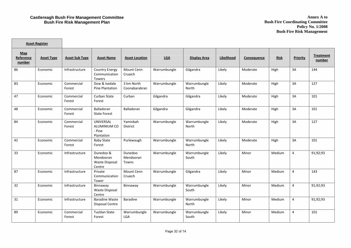
Appendix 2. Asset Register (in order of priority)
Asset Register
Map Reference
number Asset Type Asset Sub Type Asset Name Asset Location LGA Display Area Likelihood Consequence Risk Priority
Treatment number
68 Cultural Aboriginal Significance
Significant Aboriginal Cultural Site
Baradine State Forest
Warrumbungle Warrumbungle North
Almost certain
Catastrophic Extreme 1A 113
62 Cultural Aboriginal Significance
Significant Aboriginal Cultural Site
North Goonoo & Breelong CCA,
Gilgandra Gilgandra Likely Catastrophic Extreme 1B 103
70 Cultural Aboriginal Significance
Significant Aboriginal Cultural Site
Cumbil State Forest
Warrumbungle Warrumbungle North
Likely Catastrophic Extreme 1B 113
65 Cultural Aboriginal Significance
Significant Aboriginal Cultural Site
Timallallie CCA Zone 1
Warrumbungle Warrumbungle North
Likely Catastrophic Extreme 1B 103
63 Cultural Aboriginal Significance
Significant Aboriginal Cultural Site
Goonoo CCA Zone 3
Warrumbungle Warrumbungle South
Likely Catastrophic Extreme 1B 103
74 Cultural Non Indigenous Balor Hut Warrumbungle National Park
Gilgandra Gilgandra Likely Catastrophic Extreme 1B 103
66 Cultural Aboriginal Significance
Significant Aboriginal Cultural Site
Pilliga Nature Reserve
Warrumbungle Warrumbungle North
Almost certain
Major Extreme 1C 103
67 Cultural Aboriginal Significance
Significant Aboriginal Cultural Site
Wittenbra State Forest
Warrumbungle Warrumbungle North
Likely Major Very High 2A 113
64 Cultural Aboriginal Significance
Significant Aboriginal Cultural Site
Biddon CCA Zone 3 State Conservation Area
Gilgandra Gilgandra Likely Major Very High 2A 103

Annex A to Bush Fire Coordinating Committee
Policy No. 1/2008 Bush Fire Risk Management
Page 30 of 74
Castlereagh Bush Fire Management Committee Bush Fire Risk Management Plan
Asset Register
Map Reference
number Asset Type Asset Sub Type Asset Name Asset Location LGA Display Area Likelihood Consequence Risk Priority
Treatment number
71 Cultural Aboriginal Significance
Significant Aboriginal Cultural Site
Ukerbarley Reserve
Warrumbungle Warrumbungle North
Likely Major Very High 2A 103
76 Cultural Non Indigenous White Gum Lookout
Warrumbungle National Park
Gilgandra Gilgandra Likely Major Very High 2A 103
73 Cultural Non Indigenous Salisbury Waterholes
Pilliga Nature Reserve
Warrumbungle Warrumbungle North
Likely Moderate High 3A 103
80 Cultural Non Indigenous Aloes Graves Cumbil State Forest
Warrumbungle Warrumbungle North
Likely Moderate High 3A 125
79 Cultural Non Indigenous Wooleybah Saw Mill
Pilliga West State Forest
Warrumbungle Warrumbungle North
Likely Moderate High 3A 125
77 Cultural Non Indigenous Yarragrin & Dandry Gorge Picnic Areas
Yarragrin & Timmallallie CCA Zones 1 NP
Warrumbungle Warrumbungle North
Likely Moderate High 3A 103
75 Cultural Non Indigenous Strathmore Homestead Complex
Warrumbungle National Park
Gilgandra Gilgandra Likely Moderate High 3A 103
82 Cultural Aboriginal Significance
Significant Aboriginal Cultural Site
Oxley Hwy 9 Kilometres North of Coonabarabran
Warrumbungle Warrumbungle North
Likely Minor Medium 4 2
81 Cultural Non Indigenous Old Coonabarabran Cemetery
Coonabarabran Warrumbungle Warrumbungle North
Likely Minor Medium 4 128
88 Economic Infrastructure Broadcast Australia TV Tower
Mount Cenn Cruaich
Warrumbungle Gilgandra Likely Catastrophic Extreme 1B 129;130; 131;132
39 Economic Commercial Forest
Baradine and part of Orr State Forest
Baradine Warrumbungle Warrumbungle North
Almost certain
Major Extreme 1C 101

Annex A to Bush Fire Coordinating Committee
Policy No. 1/2008 Bush Fire Risk Management
Page 31 of 74
Castlereagh Bush Fire Management Committee Bush Fire Risk Management Plan
Asset Register
Map Reference
number Asset Type Asset Sub Type Asset Name Asset Location LGA Display Area Likelihood Consequence Risk Priority
Treatment number
40 Economic Commercial Forest
Wittenbra State Forest
South of Baradaine
Warrumbungle Warrumbungle North
Almost certain
Major Extreme 1C 101
30 Economic Infrastructure Siding Spring Observatory
Timor Rd. Siding Spring Mtn.
Warrumbungle Warrumbungle North
Likely Major Very High 2A 90;87;88;89
44 Economic Commercial Forest
Boyben State Forest
East of Gilgandra
Gilgandra Gilgandra Likely Major Very High 2A 101
36 Economic Commercial Forest
Merriwindi State Forest
Baradine Warrumbungle Warrumbungle North
Likely Major Very High 2A 101
37 Economic Commercial Forest
Pilliga West State Forest
Baradine Warrumbungle Warrumbungle North
Likely Major Very High 2A 101
38 Economic Commercial Forest
Cumbil & Coomore Creek State Forest
North Bugaldie Warrumbungle Warrumbungle North
Likely Major Very High 2A 101
41 Economic Commercial Forest
Kerringle State Forest
Goolhi Warrumbungle Warrumbungle North
Likely Major Very High 2A 101
43 Economic Commercial Forest
Yalcogrin State Forest
Biddon Gilgandra Gilgandra Likely Major Very High 2A 101
45 Economic Commercial Forest
Gilgandra & Eringanerin State Forests
Gilgandra Gilgandra Gilgandra Likely Major Very High 2A 101
85 Economic Infrastructure Newell Highway Newell Hwy between Coonabarabran and Zone Boundary
Warrumbungle Warrumbungle North
Almost certain
Moderate Very High 2C 133
35 Economic Infrastructure Carlginda Recycling Centre
Gilgandra Gilgandra Gilgandra Likely Moderate High 3A 91;92;93; 100
Annex A to Bush Fire Coordinating Committee
Policy No. 1/2008 Bush Fire Risk Management
Page 32 of 74
Castlereagh Bush Fire Management Committee Bush Fire Risk Management Plan
Asset Register
Map Reference
number Asset Type Asset Sub Type Asset Name Asset Location LGA Display Area Likelihood Consequence Risk Priority
Treatment number
86 Economic Infrastructure Country Energy Communication Towers
Mount Cenn Cruaich
Warrumbungle Gilgandra Likely Moderate High 3A 144
83 Economic Commercial Forest
Dow & Isedale Pine Plantation
3 km North Coonabarabran
Warrumbungle Warrumbungle North
Likely Moderate High 3A 127
47 Economic Commercial Forest
Curban State Forest
Curban Gilgandra Gilgandra Likely Moderate High 3A 101
48 Economic Commercial Forest
Balladoran State Forest
Balladoran Gilgandra Gilgandra Likely Moderate High 3A 101
84 Economic Commercial Forest
UNIVERSAL ALUMINIUM CO - Pine Plantation
Yaminbah District
Warrumbungle Warrumbungle North
Likely Moderate High 3A 127
42 Economic Commercial Forest
Baby State Forest
Purlewaugh Warrumbungle Warrumbungle North
Likely Moderate High 3A 101
33 Economic Infrastructure Dunedoo & Mendooran Waste Disposal Centre
Dunedoo Mendooran Towns
Warrumbungle Warrumbungle South
Likely Minor Medium 4 91;92;93
87 Economic Infrastructure Private Communication Tower
Mount Cenn Cruaich
Warrumbungle Gilgandra Likely Minor Medium 4 143
32 Economic Infrastructure Binnaway Waste Disposal Centre
Binnaway Warrumbungle Warrumbungle South
Likely Minor Medium 4 91;92;93
31 Economic Infrastructure Baradine Waste Disposal Centre
Baradine Warrumbungle Warrumbungle North
Likely Minor Medium 4 91;92;93
89 Economic Commercial Forest
Tucklan State Forest
Warrumbungle LGA
Warrumbungle Warrumbungle South
Likely Minor Medium 4 101

Annex A to Bush Fire Coordinating Committee
Policy No. 1/2008 Bush Fire Risk Management
Page 33 of 74
Castlereagh Bush Fire Management Committee Bush Fire Risk Management Plan
Asset Register
Map Reference
number Asset Type Asset Sub Type Asset Name Asset Location LGA Display Area Likelihood Consequence Risk Priority
Treatment number
46 Economic Commercial Forest
Berida State Forest
New Merrigal Gilgandra Gilgandra Unlikely Moderate Low NA 101
106 Environment Endangered Endangered Fauna
Goonoo & Cobbora CCA Zone 3
Warrumbungle Gilgandra; Warrumbungle North; Warrumbungle South
Likely Major Very High 2A 108
115 Environment Vulnerable Vulnerable Flora
Goonoo CCA Warrumbungle Warrumbungle South
Likely Major Very High 2A 108
114 Environment Endangered Endangered Flora
Goonoo CCA Warrumbungle Warrumbungle South
Likely Moderate High 3A 108
110 Environment Endangered Endangered Flora
Goonoo CCA, Cobbora CCA
Warrumbungle Warrumbungle South
Likely Moderate High 3A 108
108 Environment Endangered Endangered Fauna
Timallallia CCA Warrumbungle Warrumbungle North
Likely Moderate High 3A 108
107 Environment Endangered Endangered Flora
Breelong & Goonoo CCA
Warrumbungle Warrumbungle South
Likely Moderate High 3A 108
109 Environment Endangered Endangered Flora
Warrumbungle Warrumbungle North;Warrumbungle South
Likely Moderate High 3A 111
58 Environment Vulnerable Vulnerable Fauna
Goonoo CCA and Pillga NR
Gilgandra Gilgandra ;Warrumbungle North
Possible Minor Low NA 103
59 Environment Vulnerable Vulnerable Fauna
Warrumbungle NP and private land to the east
Gilgandra Gilgandra Unlikely Moderate Low NA 111

Annex A to Bush Fire Coordinating Committee
Policy No. 1/2008 Bush Fire Risk Management
Page 34 of 74
Castlereagh Bush Fire Management Committee Bush Fire Risk Management Plan
Asset Register
Map Reference
number Asset Type Asset Sub Type Asset Name Asset Location LGA Display Area Likelihood Consequence Risk Priority
Treatment number
118 Human Settlement
Residential Rural Residential Baradine Road
2 - 4km North West Coonabarabran
Warrumbungle Warrumbungle North
Almost certain
Moderate Extreme 1C 12
11 Human Settlement
Residential Rifle Range Road
Coonabarabran Warrumbungle Warrumbungle North
Likely Major Very High 2A 5;6;27;33
15 Human Settlement
Residential Stannix Park Rural Residential
Coonabarabran Warrumbungle Warrumbungle North
Likely Major Very High 2A 5;37;33;39
28 Human Settlement
Residential Homeleigh Estate Rural Residential
Warrumbungle LGA
Warrumbungle Warrumbungle North
Likely Major Very High 2A 5;37;27;54;85
21 Human Settlement
Special Fire Protection
Village Motor Inn
Gilgandra Gilgandra Gilgandra Likely Major Very High 2A 5;59;60
5 Human Settlement
Special Fire Protection
Coonabarabran High School
Coonabarabran Warrumbungle Warrumbungle North
Likely Major Very High 2A 1;2;40
13 Human Settlement
Residential Carrington Lane Coonabarabran Warrumbungle Warrumbungle North
Likely Moderate High 3A 5;37;36;54;85
4 Human Settlement
Residential Higgins Street Coonabarabran Warrumbungle Warrumbungle North
Likely Moderate High 3A 5;6;9;10;33
22 Human Settlement
Residential Pines and Aralee Estate
Gilgandra Gilgandra Gilgandra Likely Moderate High 3A 5;11;61;65;85
19 Human Settlement
Residential Baradine Warrigal St.
Baradine Warrumbungle Warrumbungle North
Likely Moderate High 3A 5;37;52;54
14 Human Settlement
Residential Bugaldie Village Bugaldie Warrumbungle Warrumbungle North
Likely Moderate High 3A 5;33;34;35;85
12 Human Settlement
Residential Koala Place Coonabarabran Warrumbungle Warrumbungle North
Likely Moderate High 3A 5;37;33;85

Annex A to Bush Fire Coordinating Committee
Policy No. 1/2008 Bush Fire Risk Management
Page 35 of 74
Castlereagh Bush Fire Management Committee Bush Fire Risk Management Plan
Asset Register
Map Reference
number Asset Type Asset Sub Type Asset Name Asset Location LGA Display Area Likelihood Consequence Risk Priority
Treatment number
9 Human Settlement
Residential Nelson Street Coonabarabran Warrumbungle Warrumbungle North
Likely Moderate High 3A 3;4;5;6;33
8 Human Settlement
Residential Camp Street Coonabarabran Warrumbungle Warrumbungle North
Likely Moderate High 3A 5;6;11;20; 33
7 Human Settlement
Residential North East Convent Hill
Coonabarabran Warrumbungle Warrumbungle North
Likely Moderate High 3A 5;6;11;16; 33;85
6 Human Settlement
Residential Clarke Street Coonabarabran Warrumbungle Warrumbungle North
Likely Moderate High 3A 5;6;11;12; 33
105 Human Settlement
Residential Armatree Village and Community
Armatree Gilgandra Gilgandra Likely Moderate High 3A 138
104 Human Settlement
Residential Coonabarabran Town
Coonabarabran Warrumbungle Warrumbungle North
Likely Moderate High 3A 5;6;11;33; 135
17 Human Settlement
Special Fire Protection
Baradine Central School
Baradine Warrumbungle Warrumbungle North
Likely Moderate High 3A 44;46;47;51
25 Human Settlement
Special Fire Protection
Gilgandra Golf Club House
Gilgandra Gilgandra Gilgandra Likely Moderate High 3A 16;33;74;75
16 Human Settlement
Special Fire Protection
Yuluwirri Kids (Day Care Centre)
Coonabarabran Warrumbungle Warrumbungle North
Likely Moderate High 3A 142;41;42; 49
23 Human Settlement
Residential Newton Street Tooraweenah Gilgandra Gilgandra Likely Minor Medium 4 5;6;37;33; 66;85
20 Human Settlement
Residential Kenebri Village Kenebri Warrumbungle Warrumbungle North
Likely Minor Medium 4 5;33;56;57;58;85
18 Human Settlement
Residential Ulamambri Village
Ulamambri Warrumbungle Warrumbungle North
Likely Minor Medium 4 5;33;55;85;136

Annex A to Bush Fire Coordinating Committee
Policy No. 1/2008 Bush Fire Risk Management
Page 36 of 74
Castlereagh Bush Fire Management Committee Bush Fire Risk Management Plan
Asset Register
Map Reference
number Asset Type Asset Sub Type Asset Name Asset Location LGA Display Area Likelihood Consequence Risk Priority
Treatment number
103 Human Settlement
Residential Gilgandra Town and Community
Gilgandra Gilgandra Gilgandra Likely Minor Medium 4 141
24 Human Settlement
Residential Balladoran Village
Gilgandra Gilgandra Gilgandra Likely Minor Medium 4 5;37;33;85;140
10 Human Settlement
Residential Barker Street Coonabarabran Warrumbungle Warrumbungle North
Likely Minor Medium 4 5;6;20;33
96 Human Settlement
Residential Binnaway Community
Binnaway Village
Warrumbungle Warrumbungle South
Likely Minor Medium 4 135
90 Human Settlement
Residential Tooraweenah Village and Community
Tooraweenah Gilgandra Gilgandra Likely Minor Medium 4 139
102 Human Settlement
Residential Curban Village and Community
Curban Gilgandra Gilgandra Likely Minor Medium 4 136
101 Human Settlement
Residential Boyben Community
35km east of Gilgandra
Gilgandra Gilgandra Likely Minor Medium 4 136
100 Human Settlement
Residential Baradine Town Baradine Warrumbungle Warrumbungle North
Likely Minor Medium 4 135
99 Human Settlement
Residential Coolah Town Community
Coolah Warrumbungle Warrumbungle North
Likely Minor Medium 4 135
98 Human Settlement
Residential South Mullaley Community
Newell Hwy South of Mullaley
Warrumbungle Warrumbungle North
Likely Minor Medium 4 135
97 Human Settlement
Residential Purlewaugh Community
Purlewaugh Area
Warrumbungle Warrumbungle North
Likely Minor Medium 4 135
27 Human Settlement
Residential Purlewaugh Village
Purlewaugh Warrumbungle Warrumbungle North
Likely Minor Medium 4 5;37;33;85

Annex A to Bush Fire Coordinating Committee
Policy No. 1/2008 Bush Fire Risk Management
Page 37 of 74
Castlereagh Bush Fire Management Committee Bush Fire Risk Management Plan
Asset Register
Map Reference
number Asset Type Asset Sub Type Asset Name Asset Location LGA Display Area Likelihood Consequence Risk Priority
Treatment number
95 Human Settlement
Residential Neilrex Community
Around the Neilrex Village
Warrumbungle Warrumbungle South
Likely Minor Medium 4 135
94 Human Settlement
Residential Mendooran Village
Mendooran Warrumbungle Warrumbungle South
Likely Minor Medium 4 135
93 Human Settlement
Residential Merrygoen Village
Merrygoen Warrumbungle Warrumbungle South
Likely Minor Medium 4 135
92 Human Settlement
Residential Leadville Village Leadville Warrumbungle Warrumbungle South
Likely Minor Medium 4 135
91 Human Settlement
Residential Dunedoo Town Dunedoo Warrumbungle Warrumbungle South
Likely Minor Medium 4 135
29 Human Settlement
Residential Yearinan Village Yerainan Warrumbungle Warrumbungle North
Unlikely Moderate Low NA 5;37;33;86;85

Annex A to Bush Fire Coordinating Committee
Policy No. 1/2008 Bush Fire Risk Management
Page 38 of 74
Castlereagh Bush Fire Management Committee Bush Fire Risk Management Plan
Appendix 3. Treatment Register (in order of priority)
Treatment Register
Treatment Ref No
Strategy Priority Action Comment Responsible
Agency Support Agency
Other Support Agency
Scheduled Action Date
Asset Ref Nos
113 Preparedness 1A Implement AHIMS Management Conditions
All treatment should aim to be consistent with AHIMS management conditions.
DPI RFS 1112;1213;1314;1415;1516
68;70;67
103 Hazard Reduction
1B Implement DECCW Reserve Fire Management Plan
Treatment should be consistent with the guidelines outlined in the current DECCW RFMS.
DECC 1112;1213;1314;1415;1516
58;61;62; 63;65;66; 64;71;73; 75;76;74; 77
129 Hazard Reduction
1B Inspect & Maintain APZ
Inspect and maintain the APZ between the surrounding fire trail and the site infrastructure.
RFS Other Broadcast Australia
1112;1213;1314;1415;1516
88
130 Preparedness 1B Construct and maintain fire trail and access road
Construct and maintain annually the surrounding fire trail and access road into the Mount Cenn Cruaich site.
RFS Other Broadcast Australia
1112;1213;1314;1415;1516
88
131 Preparedness 1B Fire fighting Equipment Training for RFS personnel
Broadcast Australia train FRNSW & RFS personnel in the use of fire fighting equipment located on site.
NSWFB;RFS Other Broadcast Australia
1112;1213;1314;1415;1516
88

Annex A to Bush Fire Coordinating Committee
Policy No. 1/2008 Bush Fire Risk Management
Page 39 of 74
Castlereagh Bush Fire Management Committee Bush Fire Risk Management Plan
Treatment Register
Treatment Ref No
Strategy Priority Action Comment Responsible
Agency Support Agency
Other Support Agency
Scheduled Action Date
Asset Ref Nos
132 Preparedness 1B Make fire fighter access available
Supply keys to access alarmed facilities and train FRNSW & RFS personnel in the use of automatic fire alarms.
NSWFB;RFS Other Broadcast Australia
1112;1213;1314;1415;1516
88
101 Preparedness 1C Maintain as per Region Fuel Management Risk Plans
Treatments should aim to be consistent with the guidelines outlined in the current Forests NSW Region Fuel Management Risk Plans.
DPI 1112;1213;1314;1415;1516
36;37;38; 40;39;41; 43;45;42; 44;46;47; 89;48
1 Preparedness 2A Develop emergency fire relocation plan
Develop emergency fire relocation plan
NSWFB Other Dept of Education and Training
1112;1213;1314
5
2 Hazard Reduction
2A Inspect & Maintain APZ
Inspect and Maintain APZ at Dept. of Education & Training Lots to the east of Coonabarabran High School
RFS RFS; Other Dept of Education and Training
1112;1213;1314;1415;1516
5;82

Annex A to Bush Fire Coordinating Committee
Policy No. 1/2008 Bush Fire Risk Management
Page 40 of 74
Castlereagh Bush Fire Management Committee Bush Fire Risk Management Plan
Treatment Register
Treatment Ref No
Strategy Priority Action Comment Responsible
Agency Support Agency
Other Support Agency
Scheduled Action Date
Asset Ref Nos
5 Community Education
2A Conduct Media Release
Improve public awareness and knowledge of bushfire issues by ensuring residents know what action to take if a bush fire occurs through an annual media release.
RFS LGA 1112;1213;1314;1415;1516
9;12;8;7; 6;4;11;10;14;13;15; 19;20;21; 22;23;24; 28;104;18;27;29
6 Ignition Management
2A Improve Fire Permit Management
Maintain regulation of the issuing of fire safety permits and follow-up action with offenders
NSWFB 1112;1213;1314;1415;1516
9;11;4;6;7;8;10;104; 23
27 Hazard Reduction
2A Inspect & Maintain SFAZ
Inspect and Maintain adjacent SFAZ as defined in Table 3.1.
DL RFS 1112;1213;1314;1415;1516
11;28
33 Ignition Management
2A Investigate fire Cause & Origin
Conduct fire cause and origin investigation for each fire incident.
RFS 1112;1213;1314;1415;1516
9;12;8;7;6;4;11;10; 14;15;18; 20;23;24; 25;7;29; 104
37 Ignition Management
2A Improve Fire Permit Management
Permit management through local Rural Fire Brigade. All applications for fire permits are to be inspected before issuing.
RFS 1112;1213;1314;1415;1516
15;28;24; 27;29;23; 19;12;13

Annex A to Bush Fire Coordinating Committee
Policy No. 1/2008 Bush Fire Risk Management
Page 41 of 74
Castlereagh Bush Fire Management Committee Bush Fire Risk Management Plan
Treatment Register
Treatment Ref No
Strategy Priority Action Comment Responsible
Agency Support Agency
Other Support Agency
Scheduled Action Date
Asset Ref Nos
39 Hazard Reduction
2A Inspect & Maintain SFAZ
Inspect and maintain SFAZ north of Stannix Park.
RFS DL;LGA; Other
Coonabarabran Aboriginal Land Council
1213;1415 15
40 Hazard Reduction
2A Inspect & Maintain SFAZ
Inspect and maintain SFAZ (Lot 598 DP821079 Dept of Education and Training).
RFS RFS; Other Dept. Education & Training
1213;1415 5
54 Ignition Management
2A Investigate fire Cause & Origin
Conduct fire cause and origin investigation for each fire incident.
RFS; Police 1112;1213;1314;1415;1516
19;13;28
59 Preparedness 2A Develop an evacuation plan
Develop and maintain evacuation Plan for the facility.
RFS Private 1112;1213;1314;1415;1516
21
60 Preparedness 2A Develop emergency fire relocation plan
Owner/Manager develop and maintain an emergency fire relocation plan.
NSWFB Other Village Motor Inn
1112;1213;1314;1415;1516
21
85 Property Planning
2A Implement Planning for Bush Fire Protection
Ensure all development applications in bush fire prone land comply with Planning for Bush Fire Protection and that all conditions are applied.
LGA 1112;1213;1314;1415;1516
28;12;13; 14;22;18; 20;24;27; 7;29;23

Annex A to Bush Fire Coordinating Committee
Policy No. 1/2008 Bush Fire Risk Management
Page 42 of 74
Castlereagh Bush Fire Management Committee Bush Fire Risk Management Plan
Treatment Register
Treatment Ref No
Strategy Priority Action Comment Responsible
Agency Support Agency
Other Support Agency
Scheduled Action Date
Asset Ref Nos
87 Hazard Reduction
2A Maintain APZ & SFAZ
Treatment should be aimed to be consistent with the guidelines in the current Siding Spring Site Protection Plan
DECC;RFS Other Australian National University
1112;1213;1314;1415;1516
30
88 Property Planning
2A Facilitate Emergency Fire Relocation Plan
Establish & maintain an emergency fire evacuation plan for the facility
RFS Other Australian National University
1112;1213;1314;1415;1516
30
89 Preparedness 2A Inspect and maintain access
Manage hazardous trees along Siding Spring Road to prevent possible road blockage from falling trees.
LGA Other Australian National University
1112;1213;1314;1415;1516
30
90 Preparedness 2A Maintain facility for a Divisional Command Post
Maintain facility for a Divisional Command Post
RFS Other Australian National University
1112;1213;1314;1415;1516
30
108 Hazard Reduction
2A Implement Wildlife Atlas Management Conditions
Any treatment should be consistent with the DECCW Atlas of NSW Wildlife
DECC 1112;1213;1314;1415;1516
115;106; 107;108; 110;114

Annex A to Bush Fire Coordinating Committee
Policy No. 1/2008 Bush Fire Risk Management
Page 43 of 74
Castlereagh Bush Fire Management Committee Bush Fire Risk Management Plan
Treatment Register
Treatment Ref No
Strategy Priority Action Comment Responsible
Agency Support Agency
Other Support Agency
Scheduled Action Date
Asset Ref Nos
133 Hazard Reduction
2C Monitor Fuel Loads
Inspect and conduct prescribed burns in SFAZ that will result in reduced fire impact on the Newell Highway.
RFS Private 1112;1213;1314;1415
85
3 Hazard Reduction
3A Create & Maintain APZ
Create APZ behind dwellings (Lot 1 DP1079661), inspect and maintain APZ
RFS DL;LGA 1112;1213;1314;1415;1516
9
4 Hazard Reduction
3A Inspect & Maintain SFAZ
Inspect and maintain SFAZ (Lot 2 DP1079661) LPMA .
DL;RFS Other Coonabarabran Aboriginal Land Council
1213;1415 9
9 Hazard Reduction
3A Inspect & Maintain SFAZ
Inspect SFAZ and maintain (Lot 1 & 2 DP1079661).
LGA;RFS Other Coonabarabran Aboriginal Land Council
1213;1415 4
10 Hazard Reduction
3A Create & Maintain APZ
Create, maintain and inspect adjacent AZP as defined in Table 3.1.
RFS LGA; Other Coonabarabran Aboriginal Land Council
1112;1213;1314;1415;1516
4
11 Hazard Reduction
3A Inspect & Maintain APZ
Inspect and maintain adjacent APZ as defined in Table 3.1.
RFS LGA;RFS 1112;1213;1314;1415;1516
6;104;7;8;22

Annex A to Bush Fire Coordinating Committee
Policy No. 1/2008 Bush Fire Risk Management
Page 44 of 74
Castlereagh Bush Fire Management Committee Bush Fire Risk Management Plan
Treatment Register
Treatment Ref No
Strategy Priority Action Comment Responsible
Agency Support Agency
Other Support Agency
Scheduled Action Date
Asset Ref Nos
12 Hazard Reduction
3A Inspect & Maintain SFAZ
Inspect and maintain adjacent SFAZ on Clark Street as defined in Table 3.1.
RFS RTA; Other Coonabarabran Aboriginal Land Council
1213;1415 6
16 Hazard Reduction
3A Inspect & Maintain SFAZ
Inspect and maintain adjacent SFAZ as defined in Table 3.1.
LGA RFS 1112;1213;1314;1415;1516
7;25;118
20 Hazard Reduction
3A Inspect & Maintain SFAZ
Inspect and Maintain adjacent SFAZ as defined in Table 3.1.
DL RFS 1112;1213;1314;1415;1516
8;10
34 Hazard Reduction
3A Inspect & Maintain APZ
Inspect and Maintain adjacent APZ as defined in Table 3.1.
DL 1112;1213;1314;1415;1516
14
35 Hazard Reduction
3A Inspect & Maintain SFAZ
Inspect and Maintain adjacent SFAZ as defined in Table 3.1.
DL;RFS Other Coonabarabran Aboriginal Land Council
1112;1314;1516
14
36 Community Education
3A Conduct Targeted Community Liaison Activities
Conduct a door knock campaign along Carrington Lane
RFS 1112;1314;1516
13
41 Property Planning
3A Develop emergency fire relocation plan
Develop emergency fire relocation plan
LGA NSWFB; RFS 1112;1213 16

Annex A to Bush Fire Coordinating Committee
Policy No. 1/2008 Bush Fire Risk Management
Page 45 of 74
Castlereagh Bush Fire Management Committee Bush Fire Risk Management Plan
Treatment Register
Treatment Ref No
Strategy Priority Action Comment Responsible
Agency Support Agency
Other Support Agency
Scheduled Action Date
Asset Ref Nos
42 Hazard Reduction
3A Inspect & Maintain SFAZ
Inspect and maintain SFAZ (Lot 598 DP821079 Dept of Education and Training).
RFS RFS; Other Dept. School Education & Training
1213;1415 16
44 Preparedness 3A Develop emergency fire relocation plan
Develop emergency fire relocation plan
RFS Other Dept of Education and Training
1112;1213;1314
17
46 Hazard Reduction
3A Create & Maintain APZ
Inspect and Maintain APZ between the Baradine Creek and Baradine Central School boundary.
RFS Other Dept Of Education and Training
1213;1415 17
47 Community Education
3A Conduct School Visit
Conduct annual school visit.
RFS Other Dep. of Education and Training
1112;1213;1314;1415;1516
17
49 Hazard Reduction
3A Inspect & Maintain APZ
Council to undertake HR and general maintenance to buildings annually
LGA 1112;1213;1314;1415;1516
16
51 Community Education
3A Conduct School Visit
Visit and conduct FireWise program annually at Baradine Central School
RFS 1112;1213;1314;1415;1516
17
52 Hazard Reduction
3A Inspect & Maintain SFAZ
Inspect and maintain SFAZ North of Warrigal Street Baradine.
RFS LGA; Other Dept. Education & Training
1112;1314;1516
19

Annex A to Bush Fire Coordinating Committee
Policy No. 1/2008 Bush Fire Risk Management
Page 46 of 74
Castlereagh Bush Fire Management Committee Bush Fire Risk Management Plan
Treatment Register
Treatment Ref No
Strategy Priority Action Comment Responsible
Agency Support Agency
Other Support Agency
Scheduled Action Date
Asset Ref Nos
61 Hazard Reduction
3A Inspect & Maintain SFAZ
Inspect and maintain SFAZ (Lot 15 DP1047720) Gilgandra Aerodrome & Lot 8 DP853253.
LGA RFS 1112;1213;1314;1415;1516
22
65 Ignition Management
3A Investigate fire Cause & Origin
Conduct fire cause and origin investigation for each fire incident.
NSWFB; RFS 1112;1213;1314;1415;1516
22
74 Preparedness 3A Develop emergency fire relocation plan
Gilgandra Golf Club management develop emergency fire relocation plan
RFS Other Gilgandra Golf Club Management
1112;1213;1314;1415;1516
25
75 Hazard Reduction
3A Inspect & Maintain APZ
Inspect and maintain an APZ between Gilgandra Golf Club house and State Forest.
RFS Other Gilgandra Golf Club Management
1112;1213;1314;1415;1516
25
91 Hazard Reduction
3A Create & Maintain APZ
Inspect and maintain annually a 3 metre wide APZ around the boundary of the Waste Disposal Centre.
LGA; RFS 1112;1213;1314;1415;1516
32;33;31; 34;35

Annex A to Bush Fire Coordinating Committee
Policy No. 1/2008 Bush Fire Risk Management
Page 47 of 74
Castlereagh Bush Fire Management Committee Bush Fire Risk Management Plan
Treatment Register
Treatment Ref No
Strategy Priority Action Comment Responsible
Agency Support Agency
Other Support Agency
Scheduled Action Date
Asset Ref Nos
92 Property Planning
3A Restrict or Manage Access
Restrict or manage access to facility during periods of very high to Catastrophic fire danger periods.
LGA 1112;1213;1314;1415;1516
31;33;34; 35;32
93 Ignition Management
3A Investigate fire Cause & Origin
Conduct fire cause and origin investigation for each fire incident and prosecute offenders
LGA RFS 1112;1213;1314;1415;1516
31;32;33; 34;35
100 Preparedness 3A Develop emergency fire relocation plan
Develop and maintain an emergency fire relocation plan for the facility
LGA NSWFB 1112;1213;1314;1415;1516
35
111 Hazard Reduction
3A Implement Wildlife Atlas Management Conditions
Any treatment should be consistent with the DECCW Atlas of NSW Wildlife
DECC; Private 1112;1213;1314;1415;1516
59;60;109
125 Preparedness 3A Maintain as per Region Fuel Management Risk Plans
Treatments should aim to be consistent with the guidelines outlined in the current Forests NSW Region Fuel Management Risk Plans.
DPI RFS 1112;1213;1314;1415;1516
79;80

Annex A to Bush Fire Coordinating Committee
Policy No. 1/2008 Bush Fire Risk Management
Page 48 of 74
Castlereagh Bush Fire Management Committee Bush Fire Risk Management Plan
Treatment Register
Treatment Ref No
Strategy Priority Action Comment Responsible
Agency Support Agency
Other Support Agency
Scheduled Action Date
Asset Ref Nos
127 Hazard Reduction
3A Maintain Industry Standards for fire protection
Maintain Industry Standards for fire protection.
RFS Private 1112;1213;1314;1415;1516
83;84
135 Preparedness 3A Maintain Neighbourhood Safer Places
Inspect and maintain by mowing or slashing APZ in the vicinity of the NSP area.
LGA 1112;1213;1314;1415;1516
91;92;93; 94;95;96; 97;98;100;104;99
138 Preparedness 3A Maintain Neighbourhood Safer Places
Inspect and maintain by mowing or slashing APZ in the vicinity of the NSP area.
RFS LGA; Other Country Women’s Assoc.
1112;1213;1314;1415;1516
105
142 Community Education
3A Conduct a FireWise Presentation at Pre-School
Annually conduct a Kids FireWise Presentation.
RFS 1112;1213;1314;1415;1516
16
144 Hazard Reduction
3A Create & Maintain APZ
Inspect and maintain AZP around Essential Energy communication towers.
RFS Private; Other
Essential Energy
1112;1213;1314;1415;1516
86
55 Hazard Reduction
4 Inspect & Maintain SFAZ
Inspect and maintain SFAZ (Lot 131 DP754983, LPMA).
LGA RFS 1213;1415 18

Annex A to Bush Fire Coordinating Committee
Policy No. 1/2008 Bush Fire Risk Management
Page 49 of 74
Castlereagh Bush Fire Management Committee Bush Fire Risk Management Plan
Treatment Register
Treatment Ref No
Strategy Priority Action Comment Responsible
Agency Support Agency
Other Support Agency
Scheduled Action Date
Asset Ref Nos
56 Hazard Reduction
4 Inspect & Maintain SFAZ
Inspect and Maintain SFAZ West of Kenebri Village.
RFS DL 1213;1415 20
57 Ignition Management
4 Investigate fire Cause & Origin
Conduct fire cause and origin investigation for each fire incident.
NSWFB; Police
RFS 1112;1213;1314;1415;1516
20
58 Property Planning
4 Maintain Fire Trail
Inspect and maintain fire trail to the west of the village between SFAZ and Village
DL 1112;1314;1516
20
66 Hazard Reduction
4 Inspect & Maintain APZ
Inspect and maintain adjacent APZ to Newton Street Coonabarabran.
DL RFS 1112;1213;1314;1415;1516
23
128 Hazard Reduction
4 Inspect & Maintain SFAZ
Inspect and maintain SFAZ around the Old Coonabarabran Cemetery.
RFS LGA; Other Coonabarabran Aboriginal Land Council
1112;1213;1314;1415;1516
81
136 Preparedness 4 Maintain Neighbourhood Safer Places
Inspect and maintain by mowing or slashing APZ in the vicinity of the NSP area.
LGA RFS 1112;1213;1314;1415;1516
101;102; 18
139 Preparedness 4 Maintain Neighbourhood Safer Places
Inspect and maintain by mowing or slashing APZ in the vicinity of the NSP area.
RFS LGA; Other Dept of Education and Training
1112;1213;1314;1415;1516
90

Annex A to Bush Fire Coordinating Committee
Policy No. 1/2008 Bush Fire Risk Management
Page 50 of 74
Castlereagh Bush Fire Management Committee Bush Fire Risk Management Plan
Treatment Register
Treatment Ref No
Strategy Priority Action Comment Responsible
Agency Support Agency
Other Support Agency
Scheduled Action Date
Asset Ref Nos
140 Preparedness 4 Maintain Neighbourhood Safer Places
Maintain by mowing or slashing APZ in the vicinity of the NSP area.
RFS Other NSW Grain Corp.
1112;1213;1314;1415;1516
24
141 Preparedness 4 Maintain Neighbourhood Safer Places
Inspect and maintain by mowing or slashing APZ in the vicinity of the NSP area.
RFS Private 1112;1213;1314;1415;1516
103
143 Hazard Reduction
4 Create & Maintain APZ
Inspect and maintain AZP around private communication towers.
RFS Private 1112;1213;1314;1415;1516
87
86 Hazard Reduction
NA Maintain Roadside Slashing Regime
Inspect and maintain roadside slashing along Rundle Road access through Yearinan Village.
LGA 1112;1213;1314;1415;1516
29

Annex A to Bush Fire Coordinating Committee
Policy No. 1/2008 Bush Fire Risk Management
Page 51 of 74
Castlereagh Bush Fire Management Committee Bush Fire Risk Management Plan
Appendix 4. Castlereagh BFMC Fire Trail Register
Castlereagh BFMC Fire Trail Register
Zone Trail Name Trail Length (Metres)
Trail Length (Kilometres)
Date Entered
Date Modified Trail Class Vehicle Land
Manager Type
Castlereagh 580.431 0.580 9/06/2006 9/06/2006 Castlereagh 1570.230 1.570 9/09/2009 9/09/2009 Essential Category 1 Other Fire Trail Castlereagh 1653.682 1.654 9/09/2009 9/09/2009 Essential Category 9 National
Park Fire Trail
Castlereagh 1351.285 1.351 9/09/2009 9/09/2009 Important Category 1 Other Fire Trail Castlereagh 1997 Control Line 20 2846.417 2.846 7/07/2009 7/07/2009 Essential Category 7 Private Fire Trail Castlereagh 1997 Control Line 20 5119.367 5.119 7/07/2009 7/07/2009 Dormant Category 7 Private Fire Trail Castlereagh A Line Road 1877.729 1.878 25/06/2009 25/06/2009 Important Category 1 National
Park Fire Trail
Castlereagh A Line Road 14551.175 14.551 25/05/2010 25/05/2010 Important Category 1 State Forest
Fire Trail
Castlereagh ARTC Crossing 19.185 0.019 10/09/2009 10/09/2009 Essential Category 7 Rail Corp Fire Trail Castlereagh ARTC Maintenance Track 3588.140 3.588 10/09/2009 10/09/2009 Essential Category 1 Other Fire Trail Castlereagh ARTC Maintenance Track 2926.192 2.926 10/09/2009 10/09/2009 Essential Category 1 Rail Corp Fire Trail Castlereagh ARTC Maintenance Track 17190.943 17.191 10/09/2009 10/09/2009 Essential Category 7 Rail Corp Fire Trail Castlereagh Acacia Road 3801.320 3.801 18/06/2009 18/06/2009 Essential Category 1 National
Park Fire Trail
Castlereagh Allens Road 4254.395 4.254 10/07/2009 10/07/2009 Essential Category 1 National Park
Fire Trail
Castlereagh Allens Road 2163.023 2.163 25/05/2010 25/05/2010 Essential Category 1 State Forest
Fire Trail
Castlereagh Allens Road 2478.034 2.478 10/07/2009 10/07/2009 Important Category 1 National Park
Fire Trail
Castlereagh Anchor Trail 2266.083 2.266 18/05/2010 18/05/2010 Unassigned Unassigned Private Unknown Castlereagh Anchor Trail 2027.985 2.028 18/05/2010 18/05/2010 Unassigned Unassigned Private Fire Trail Castlereagh B Line Road 12151.917 12.152 25/05/2010 25/05/2010 Important Category 1 State
Forest Fire Trail
Castlereagh Badham Trail 9852.933 9.853 29/06/2009 29/06/2009 Essential Category 7 National Park
Fire Trail

Annex A to Bush Fire Coordinating Committee
Policy No. 1/2008 Bush Fire Risk Management
Page 52 of 74
Castlereagh Bush Fire Management Committee Bush Fire Risk Management Plan
Castlereagh BFMC Fire Trail Register
Zone Trail Name Trail Length (Metres)
Trail Length (Kilometres)
Date Entered
Date Modified Trail Class Vehicle Land
Manager Type
Castlereagh Baglees Trail 5751.344 5.751 8/06/2010 8/06/2010 Dormant Unassigned Private Fire Trail Castlereagh Bagshaws Fire Trail 2500.467 2.500 11/09/2009 11/09/2009 Essential Category 1 National
Park Fire Trail
Castlereagh Balladoran Road 1823.101 1.823 9/09/2009 9/09/2009 Essential Category 7 National Park
Fire Trail
Castlereagh Balladoran Road 2061.544 2.062 9/09/2009 9/09/2009 Important Category 7 National Park
Fire Trail
Castlereagh Balmoral Road 2267.850 2.268 10/12/2010 10/12/2010 Important Category 1 National Park
Fire Trail
Castlereagh Bangalore Trail 8696.888 8.697 19/05/2010 19/05/2010 Dormant Category 9 Private Fire Trail Castlereagh Banksia Trail 797.838 0.798 29/06/2009 29/06/2009 Essential Category 1 National
Park Fire Trail
Castlereagh Banksia Trail 11044.064 11.044 29/06/2009 29/06/2009 Essential Category 9 National Park
Fire Trail
Castlereagh Baradine Creek Road 6091.656 6.092 25/05/2010 25/05/2010 Important Category 1 State Forest
Fire Trail
Castlereagh Baradine Dandry Road 1008.778 1.009 9/06/2006 9/06/2006 Essential Category 1 Private Castlereagh Barracks Car Park loop 52.928 0.053 26/06/2009 26/06/2009 Dormant Category 1 National
Park Fire Trail
Castlereagh Barwick Road 2783.700 2.784 9/09/2009 9/09/2009 Unassigned Unassigned National Park
Fire Trail
Castlereagh Belah Road 3950.935 3.951 18/06/2009 18/06/2009 Essential Category 1 National Park
Fire Trail
Castlereagh Belougerie Flats Trail 61.941 0.062 11/09/2009 11/09/2009 Essential Category 1 National Park
Fire Trail
Castlereagh Bennewit Trail 6952.470 6.952 8/06/2010 8/06/2010 Dormant Unassigned Private Fire Trail Castlereagh Bentwood Trail 1410.938 1.411 18/05/2010 18/05/2010 Essential Category 7 Other Fire Trail Castlereagh Bentwood Trail 21359.219 21.359 18/05/2010 19/05/2010 Essential Category 7 Private Fire Trail Castlereagh Berrlong Road 1724.309 1.724 9/09/2009 9/09/2009 Essential Category 1 National
Park Fire Trail
Castlereagh Bringers Management Trail 3411.039 3.411 10/09/2009 10/09/2009 Important Category 7 National Park
Fire Trail
Castlereagh Black Pine Road 8677.092 8.677 25/05/2010 25/05/2010 Essential Category 1 State Forest
Fire Trail

Annex A to Bush Fire Coordinating Committee
Policy No. 1/2008 Bush Fire Risk Management
Page 53 of 74
Castlereagh Bush Fire Management Committee Bush Fire Risk Management Plan
Castlereagh BFMC Fire Trail Register
Zone Trail Name Trail Length (Metres)
Trail Length (Kilometres)
Date Entered
Date Modified Trail Class Vehicle Land
Manager Type
Castlereagh Black Pine Road 4038.483 4.038 18/06/2009 18/06/2009 Important Category 1 State Forest
Fire Trail
Castlereagh Blue Nobby Road 5990.452 5.990 10/07/2009 10/07/2009 Essential Category 1 National Park
Fire Trail
Castlereagh Blue Nobby Road 119.868 0.120 10/07/2009 10/07/2009 Essential Category 9 National Park
Fire Trail
Castlereagh Boomley Fire Trail 5737.380 5.737 23/06/2009 23/06/2009 Dormant Unassigned National Park
Fire Trail
Castlereagh Borah Creek Road 16159.222 16.159 10/07/2009 10/07/2009 Essential Category 1 National Park
Fire Trail
Castlereagh Breelong Road 6105.775 6.106 9/09/2009 9/09/2009 Important Category 1 National Park
Fire Trail
Castlereagh Brennans Road 254.150 0.254 10/09/2009 10/09/2009 Essential Category 1 National Park
Fire Trail
Castlereagh Bringers Management Trail 1791.214 1.791 10/09/2009 10/09/2009 Important Category 7 National Park
Fire Trail
Castlereagh Brolga Street 512.135 0.512 18/06/2009 18/06/2009 Essential Category 1 National Park
Fire Trail
Castlereagh Browns Creek Trail 8.005 0.008 10/09/2009 10/09/2009 Essential Category 7 National Park
Fire Trail
Castlereagh Browns Road 5494.279 5.494 25/05/2010 25/05/2010 Important Category 1 State Forest
Fire Trail
Castlereagh Brynog Trail 1915.314 1.915 8/06/2010 8/06/2010 Unassigned Unassigned Private Fire Trail Castlereagh Bugaldie Silo Road 513.144 0.513 18/06/2009 18/06/2009 Essential Category 9 Other Fire Trail Castlereagh Bundella Lookout Trail 154.553 0.155 26/06/2009 26/06/2009 Dormant Category 9 National
Park Fire Trail
Castlereagh Bundella Trail 6433.985 6.434 26/06/2009 26/06/2009 Important Category 9 National Park
Fire Trail
Castlereagh Burbie Trail 13169.976 13.170 10/09/2009 10/09/2009 Essential Category 1 National Park
Fire Trail
Castlereagh Camlins Road 2170.165 2.170 9/09/2009 9/09/2009 Unassigned Category 1 National Park
Fire Trail
Castlereagh Camp Road 4249.867 4.250 10/12/2010 10/12/2010 Essential Category 1 National Park
Fire Trail

Annex A to Bush Fire Coordinating Committee
Policy No. 1/2008 Bush Fire Risk Management
Page 54 of 74
Castlereagh Bush Fire Management Committee Bush Fire Risk Management Plan
Castlereagh BFMC Fire Trail Register
Zone Trail Name Trail Length (Metres)
Trail Length (Kilometres)
Date Entered
Date Modified Trail Class Vehicle Land
Manager Type
Castlereagh Caravan Corner Road 1849.939 1.850 29/06/2009 29/06/2009 Essential Category 1 National Park
Fire Trail
Castlereagh Cenn Cruaich Trail 6719.188 6.719 7/12/2010 7/12/2010 Essential Category 1 Private Fire Trail Castlereagh Central Fire Trail 3252.953 3.253 23/06/2009 23/06/2009 Dormant Unassigned National
Park Fire Trail
Castlereagh Central Trail 2432.676 2.433 10/12/2010 10/12/2010 Essential Category 1 Other Fire Trail Castlereagh Charcoal - Loan Hill Link
Road 1444.976 1.445 10/12/2010 10/12/2010 Important Category 1 National
Park Fire Trail
Castlereagh Chews Road 3718.403 3.718 25/05/2010 25/05/2010 Important Category 1 Other Fire Trail Castlereagh Chinamans Swamp Trail 5790.171 5.790 26/06/2009 26/06/2009 Important Category 9 National
Park Fire Trail
Castlereagh Clift Road 4670.677 4.671 25/05/2010 25/05/2010 Important Category 1 State Forest
Fire Trail
Castlereagh Cline Road 8757.337 8.757 25/05/2010 25/05/2010 Essential Category 1 State Forest
Fire Trail
Castlereagh Cluffs Road 3173.982 3.174 26/06/2009 26/06/2009 Important Category 1 National Park
Fire Trail
Castlereagh Camlins Road 442.671 0.443 9/09/2009 9/09/2009 Unassigned Category 1 National Park
Fire Trail
Castlereagh Cobbora Forest Fire Trail 5074.389 5.074 23/06/2009 23/06/2009 Dormant Unassigned National Park
Fire Trail
Castlereagh Cobbora Reserve Access 184.872 0.185 9/06/2006 9/06/2006 Unassigned Category 1 National Park
Other Fire Access
Castlereagh Cobbora Reserve Access 2219.494 2.219 9/06/2006 22/06/2009 Dormant Category 1 National Park
Other Fire Access
Castlereagh Condrens Mistake 3382.005 3.382 25/05/2010 25/05/2010 Important Category 1 State Forest
Fire Trail
Castlereagh Coopers Road 13234.814 13.235 7/07/2009 7/07/2009 Essential Category 1 National Park
Fire Trail
Castlereagh Country Energy Trail 6665.995 6.666 8/06/2010 8/06/2010 Dormant Category 9 Private Fire Trail Castlereagh Cox Creek Trail 3087.500 3.087 26/06/2009 26/06/2009 Important Category 9 National
Park Fire Trail
Castlereagh Coxs Creek Camping Access Trail
726.674 0.727 26/06/2009 26/06/2009 Important Category 1 National Park
Fire Trail

Annex A to Bush Fire Coordinating Committee
Policy No. 1/2008 Bush Fire Risk Management
Page 55 of 74
Castlereagh Bush Fire Management Committee Bush Fire Risk Management Plan
Castlereagh BFMC Fire Trail Register
Zone Trail Name Trail Length (Metres)
Trail Length (Kilometres)
Date Entered
Date Modified Trail Class Vehicle Land
Manager Type
Castlereagh Crokers Road 1897.034 1.897 17/11/1998 17/11/1998 Essential Category 1 State Forest
Castlereagh Crokers Road 1526.510 1.527 25/05/2010 25/05/2010 Essential Category 1 National Park
Fire Trail
Castlereagh Crokers Road 3838.613 3.839 25/05/2010 25/05/2010 Essential Category 1 State Forest
Fire Trail
Castlereagh Cross Road 5415.529 5.416 9/09/2009 9/09/2009 Unassigned Category 9 National Park
Fire Trail
Castlereagh Cluffs Road 49.705 0.050 26/06/2009 26/06/2009 Important Category 1 National Park
Fire Trail
Castlereagh Cumbil Road 17613.066 17.613 25/05/2010 25/05/2010 Essential Category 1 Other Fire Trail Castlereagh Cumbil Road 4184.567 4.185 25/05/2010 25/05/2010 Essential Category 1 State
Forest Fire Trail
Castlereagh Dandry - Newell Link Trail 1601.704 1.602 10/07/2009 10/07/2009 Essential Category 1 National Park
Fire Trail
Castlereagh Dandry Creek Road 2123.717 2.124 29/06/2009 29/06/2009 Essential Category 1 National Park
Fire Trail
Castlereagh Dandry Creek Road 6111.528 6.112 29/06/2009 29/06/2009 Important Category 1 National Park
Fire Trail
Castlereagh Dandry Road 3959.045 3.959 29/06/2009 29/06/2009 Essential Category 1 National Park
Fire Trail
Castlereagh Darkos Trail 5859.604 5.860 7/07/2009 7/07/2009 Essential Category 1 National Park
Fire Trail
Castlereagh Dead Mans Road 4639.980 4.640 9/09/2009 9/09/2009 Important Category 1 National Park
Fire Trail
Castlereagh Denmire Fire Trail 7504.840 7.505 10/09/2009 10/09/2009 Important Category 1 National Park
Fire Trail
Castlereagh Denmire Road 2428.030 2.428 9/09/2009 9/09/2009 Essential Category 1 National Park
Fire Trail
Castlereagh Hut Road 4527.645 4.528 9/09/2009 9/09/2009 Important Category 9 National Park
Fire Trail
Castlereagh Dingo Hole Road 4142.935 4.143 25/05/2010 25/05/2010 Important Category 1 State Forest
Fire Trail
Castlereagh Dipper Road 4905.880 4.906 2/11/2009 2/11/2009 Essential Category 1 National Park
Fire Trail

Annex A to Bush Fire Coordinating Committee
Policy No. 1/2008 Bush Fire Risk Management
Page 56 of 74
Castlereagh Bush Fire Management Committee Bush Fire Risk Management Plan
Castlereagh BFMC Fire Trail Register
Zone Trail Name Trail Length (Metres)
Trail Length (Kilometres)
Date Entered
Date Modified Trail Class Vehicle Land
Manager Type
Castlereagh Dog Road 1197.083 1.197 25/05/2010 25/05/2010 Important Category 1 State Forest
Fire Trail
Castlereagh Dooroombah Trail 4436.642 4.437 26/07/2010 26/07/2010 Dormant Category 7 Private Fire Trail Castlereagh Dooroombah Trail 5174.896 5.175 26/07/2010 26/07/2010 Dormant Category 7 Private Fire Trail Castlereagh Dove Road 2328.741 2.329 29/06/2009 29/06/2009 Important Category 7 National
Park Fire Trail
Castlereagh Duggins Road 8075.467 8.075 29/06/2009 29/06/2009 Important Category 1 National Park
Fire Trail
Castlereagh Duncan Head Road 9272.164 9.272 25/05/2010 25/05/2010 Important Category 1 State Forest
Fire Trail
Castlereagh Ear Road 1860.819 1.861 18/06/2009 18/06/2009 Important Category 1 National Park
Fire Trail
Castlereagh Easement Trail 76.678 0.077 10/07/2009 10/07/2009 Essential Category 1 Other Fire Trail Castlereagh Easement Trail 1922.710 1.923 10/07/2009 10/07/2009 Essential Category 1 National
Park Fire Trail
Castlereagh East Prong Road 3867.257 3.867 25/05/2010 25/05/2010 Important Category 1 State Forest
Fire Trail
Castlereagh East Side Road 6299.794 6.300 10/12/2010 10/12/2010 Essential Category 1 National Park
Fire Trail
Castlereagh East West Road 10868.012 10.868 25/05/2010 25/05/2010 Essential Category 1 State Forest
Fire Trail
Castlereagh Eastburn Trail 769.196 0.769 9/06/2006 9/06/2006 Important Category 1 Castlereagh Eastburn Trail 6348.190 6.348 7/07/2009 7/07/2009 Important Category 1 Private Fire Trail Castlereagh Eastern Boundary Fire Trail 2074.460 2.074 10/09/2009 10/09/2009 Essential Category 1 National
Park Fire Trail
Castlereagh Eastern Fire Trail 6168.554 6.169 23/06/2009 23/06/2009 Dormant Unassigned National Park
Fire Trail
Castlereagh Eastern Trail 3509.174 3.509 10/12/2010 10/12/2010 Essential Category 1 National Park
Fire Trail
Castlereagh Ellerslie Road 2278.463 2.278 18/06/2009 18/06/2009 Essential Category 1 Other Fire Trail Castlereagh Ellerslie Road 1949.495 1.949 18/06/2009 18/06/2009 Essential Category 1 National
Park Fire Trail
Castlereagh Ellerslie Road 2382.758 2.383 25/05/2010 25/05/2010 Essential Category 1 State Forest
Fire Trail

Annex A to Bush Fire Coordinating Committee
Policy No. 1/2008 Bush Fire Risk Management
Page 57 of 74
Castlereagh Bush Fire Management Committee Bush Fire Risk Management Plan
Castlereagh BFMC Fire Trail Register
Zone Trail Name Trail Length (Metres)
Trail Length (Kilometres)
Date Entered
Date Modified Trail Class Vehicle Land
Manager Type
Castlereagh Enright Road 5306.280 5.306 18/06/2009 18/06/2009 Essential Category 1 National Park
Fire Trail
Castlereagh Errenbri Road 7403.523 7.404 25/05/2010 25/05/2010 Essential Category 1 State Forest
Fire Trail
Castlereagh Eye Road 1885.378 1.885 18/06/2009 18/06/2009 Important Category 1 National Park
Fire Trail
Castlereagh F Line Road 3951.049 3.951 18/06/2009 18/06/2009 Essential Category 1 National Park
Fire Trail
Castlereagh Fair Oak Road 4909.746 4.910 10/12/2010 10/12/2010 Important Category 1 State Forest
Fire Trail
Castlereagh Falcon Road 3369.105 3.369 10/07/2009 10/07/2009 Important Category 1 National Park
Fire Trail
Castlereagh Falcon Road 4034.240 4.034 29/06/2009 29/06/2009 Important Category 1 National Park
Fire Trail
Castlereagh Far End Road 2066.144 2.066 10/12/2010 10/12/2010 Essential Category 1 Other Fire Trail Castlereagh Far End Road -01 2497.390 2.497 10/12/2010 10/12/2010 Essential Category 1 National
Park Fire Trail
Castlereagh Farmers Road 4193.537 4.194 9/09/2009 9/09/2009 Essential Category 1 National Park
Fire Trail
Castlereagh Farmers Road 5562.015 5.562 9/09/2009 9/09/2009 Essential Category 7 National Park
Fire Trail
Castlereagh Fire Trail No1 Trail 1977.174 1.977 10/09/2009 10/09/2009 Important Category 7 National Park
Fire Trail
Castlereagh Fire Trail No2 Trail 2383.407 2.383 10/09/2009 10/09/2009 Important Category 7 National Park
Fire Trail
Castlereagh Flaggy Creek Trail 2617.991 2.618 18/05/2010 18/05/2010 Unassigned Unassigned Private Fire Trail Castlereagh Flaggy Creek Trail 298.436 0.298 18/05/2010 18/05/2010 Unassigned Unassigned Private Fire Trail Castlereagh Flaggy Creek Trail 8675.856 8.676 18/05/2010 18/05/2010 Unassigned Unassigned Private Fire Trail Castlereagh Flans Road 14160.204 14.160 9/09/2009 9/09/2009 Unassigned Unassigned National
Park Fire Trail
Castlereagh Fly Road 1109.819 1.110 18/06/2009 18/06/2009 Important Category 7 National Park
Fire Trail
Castlereagh Fork Road 1650.564 1.651 25/05/2010 25/05/2010 Important Category 1 State Forest
Fire Trail

Annex A to Bush Fire Coordinating Committee
Policy No. 1/2008 Bush Fire Risk Management
Page 58 of 74
Castlereagh Bush Fire Management Committee Bush Fire Risk Management Plan
Castlereagh BFMC Fire Trail Register
Zone Trail Name Trail Length (Metres)
Trail Length (Kilometres)
Date Entered
Date Modified Trail Class Vehicle Land
Manager Type
Castlereagh Fraser Road 3683.847 3.684 9/09/2009 9/09/2009 Unassigned Unassigned National Park
Fire Trail
Castlereagh Frazers Road 292.324 0.292 10/09/2009 10/09/2009 Important Category 1 National Park
Fire Trail
Castlereagh Garling Road 1478.801 1.479 10/09/2009 10/09/2009 Important Category 1 National Park
Fire Trail
Castlereagh Gibbican Road 409.772 0.410 25/06/2009 25/06/2009 Essential Category 1 National Park
Fire Trail
Castlereagh Gleneda Trail 1226.094 1.226 26/07/2010 26/07/2010 Dormant Category 7 Private Fire Trail Castlereagh Gleneda Trail 2581.328 2.581 26/07/2010 26/07/2010 Dormant Category 9 Private Fire Trail Castlereagh Glenn Road 907.280 0.907 9/09/2009 9/09/2009 Unassigned Category 1 National
Park Fire Trail
Castlereagh Grange Road 1674.756 1.675 9/09/2009 9/09/2009 Unassigned Unassigned National Park
Fire Trail
Castlereagh Grass Tree Trail 995.890 0.996 26/06/2009 26/06/2009 Dormant Category 9 National Park
Fire Trail
Castlereagh Greenslopes Trail 166.907 0.167 11/09/2009 11/09/2009 Essential Category 7 National Park
Fire Trail
Castlereagh Gunneemooroo Trail 2913.661 2.914 10/09/2009 10/09/2009 Essential Category 1 National Park
Fire Trail
Castlereagh Halfway Road 1544.811 1.545 10/12/2010 10/12/2010 Essential Category 1 State Forest
Fire Trail
Castlereagh Hardys Block 3718.659 3.719 10/07/2009 10/07/2009 Essential Category 1 National Park
Fire Trail
Castlereagh Hardys Trail 1113.431 1.113 10/07/2009 10/07/2009 Essential Category 1 National Park
Fire Trail
Castlereagh Harvey Road 1510.354 1.510 9/09/2009 9/09/2009 Unassigned Unassigned National Park
Fire Trail
Castlereagh Harvey Road 2958.074 2.958 9/09/2009 9/09/2009 Unassigned Unassigned National Park
Fire Trail
Castlereagh Harvey Road 469.824 0.470 9/09/2009 9/09/2009 Unassigned Unassigned National Park
Fire Trail
Castlereagh Hawk Road 5909.078 5.909 29/06/2009 29/06/2009 Important Category 1 National Park
Fire Trail

Annex A to Bush Fire Coordinating Committee
Policy No. 1/2008 Bush Fire Risk Management
Page 59 of 74
Castlereagh Bush Fire Management Committee Bush Fire Risk Management Plan
Castlereagh BFMC Fire Trail Register
Zone Trail Name Trail Length (Metres)
Trail Length (Kilometres)
Date Entered
Date Modified Trail Class Vehicle Land
Manager Type
Castlereagh Hawk Road 2865.632 2.866 25/05/2010 25/05/2010 Important Category 1 State Forest
Fire Trail
Castlereagh Heleys Road 1705.902 1.706 25/06/2009 25/06/2009 Essential Category 1 National Park
Fire Trail
Castlereagh Heleys Road 6508.142 6.508 25/05/2010 25/05/2010 Important Category 1 State Forest
Fire Trail
Castlereagh Heleys Road - 01 1429.115 1.429 25/06/2009 25/06/2009 Essential Category 1 National Park
Fire Trail
Castlereagh Henderson Road 13833.198 13.833 9/09/2009 9/09/2009 Essential Category 1 National Park
Fire Trail
Castlereagh Heughs Road 8511.278 8.511 25/05/2010 25/05/2010 Important Category 1 State Forest
Fire Trail
Castlereagh Hildegard Road 3327.409 3.327 26/06/2009 26/06/2009 Essential Category 1 National Park
Fire Trail
Castlereagh Hill Road 4767.469 4.767 10/09/2009 10/09/2009 Essential Category 7 National Park
Fire Trail
Castlereagh Hillside Trail 1946.402 1.946 10/07/2009 10/07/2009 Essential Category 1 National Park
Fire Trail
Castlereagh Hunts Road 1632.433 1.632 25/05/2010 25/05/2010 Essential Category 1 State Forest
Fire Trail
Castlereagh Indian Trail 977.788 0.978 25/05/2010 25/05/2010 Essential Category 1 State Forest
Fire Trail
Castlereagh Indian Trail 678.076 0.678 25/05/2010 25/05/2010 Important Category 1 State Forest
Fire Trail
Castlereagh Joes Hut Access Trail 210.645 0.211 26/06/2009 26/06/2009 Dormant Category 9 National Park
Fire Trail
Castlereagh Johnsons Lane 4920.644 4.921 25/05/2010 25/05/2010 Essential Category 1 National Park
Fire Trail
Castlereagh Kanangra Trail 4250.414 4.250 8/06/2010 8/06/2010 Unassigned Unassigned Private Fire Trail Castlereagh Karringal Road 5823.193 5.823 25/05/2010 25/05/2010 Important Category 1 State
Forest Fire Trail
Castlereagh Kartzhoff Road 3414.904 3.415 9/09/2009 9/09/2009 Important Category 1 National Park
Fire Trail
Castlereagh Kaufmann North Trail 3858.630 3.859 18/05/2010 18/05/2010 Unassigned Unassigned Private Fire Trail

Annex A to Bush Fire Coordinating Committee
Policy No. 1/2008 Bush Fire Risk Management
Page 60 of 74
Castlereagh Bush Fire Management Committee Bush Fire Risk Management Plan
Castlereagh BFMC Fire Trail Register
Zone Trail Name Trail Length (Metres)
Trail Length (Kilometres)
Date Entered
Date Modified Trail Class Vehicle Land
Manager Type
Castlereagh Kaufmann Trail 5199.474 5.199 18/05/2010 18/05/2010 Unassigned Unassigned Private Fire Trail Castlereagh Kerringle Road 314.919 0.315 10/07/2009 10/07/2009 Essential Category 1 National
Park Fire Trail
Castlereagh Kings Road 3347.701 3.348 10/12/2010 10/12/2010 Essential Category 1 National Park
Fire Trail
Castlereagh Kookaburra Road 2803.046 2.803 25/05/2010 25/05/2010 Important Category 1 State Forest
Fire Trail
Castlereagh Kurrajong Road 4040.162 4.040 18/06/2009 18/06/2009 Important Category 1 National Park
Fire Trail
Castlereagh Limestone Road 8553.499 8.553 29/06/2009 29/06/2009 Important Category 1 National Park
Fire Trail
Castlereagh Lizard Road 3310.283 3.310 18/06/2009 18/06/2009 Essential Category 1 National Park
Fire Trail
Castlereagh Loan Hill Rd Dan Access Trail
518.093 0.518 10/12/2010 10/12/2010 Important Category 1 National Park
Fire Trail
Castlereagh Loan Hill Road 4269.543 4.270 10/12/2010 10/12/2010 Essential Category 1 National Park
Fire Trail
Castlereagh Log Road 4326.084 4.326 18/06/2009 18/06/2009 Essential Category 1 Other Fire Trail Castlereagh MIdd Road 4403.391 4.403 10/12/2010 10/12/2010 Essential Category 1 National
Park Fire Trail
Castlereagh Macrozamia Road 3884.083 3.884 10/07/2009 10/07/2009 Essential Category 9 National Park
Fire Trail
Castlereagh Mags Road 11781.243 11.781 25/05/2010 25/05/2010 Essential Category 1 State Forest
Fire Trail
Castlereagh Mags Road 1645.012 1.645 25/05/2010 25/05/2010 Important Category 1 State Forest
Fire Trail
Castlereagh Mancers Lane 14079.548 14.080 21/05/2010 21/05/2010 Essential Category 1 National Park
Fire Trail
Castlereagh Mani Road 1967.308 1.967 25/05/2010 25/05/2010 Important Category 1 State Forest
Fire Trail
Castlereagh Margos Road 9868.903 9.869 25/05/2010 25/05/2010 Essential Category 1 State Forest
Fire Trail
Castlereagh Merebene South Road 4045.392 4.045 25/05/2010 25/05/2010 Important Category 1 State Forest
Fire Trail

Annex A to Bush Fire Coordinating Committee
Policy No. 1/2008 Bush Fire Risk Management
Page 61 of 74
Castlereagh Bush Fire Management Committee Bush Fire Risk Management Plan
Castlereagh BFMC Fire Trail Register
Zone Trail Name Trail Length (Metres)
Trail Length (Kilometres)
Date Entered
Date Modified Trail Class Vehicle Land
Manager Type
Castlereagh Merrie Road 3840.948 3.841 10/09/2009 10/09/2009 Essential Category 1 National Park
Fire Trail
Castlereagh Merrie Road 1627.891 1.628 10/09/2009 10/09/2009 Essential Category 9 National Park
Fire Trail
Castlereagh Midd Road - Western Section
1249.139 1.249 10/12/2010 10/12/2010 Essential Category 1 National Park
Fire Trail
Castlereagh Middle Fire Trail 13048.869 13.049 21/05/2010 21/05/2010 Essential Category 1 National Park
Fire Trail
Castlereagh Middlecrossing Road 1549.309 1.549 29/06/2009 29/06/2009 Important Category 1 National Park
Fire Trail
Castlereagh Mirrie Road 6730.296 6.730 10/09/2009 10/09/2009 Important Category 1 National Park
Fire Trail
Castlereagh Mistletoe Road 5945.997 5.946 25/05/2010 25/05/2010 Essential Category 1 Other Fire Trail Castlereagh Moke Road 4296.646 4.297 18/06/2009 18/06/2009 Essential Category 1 National
Park Fire Trail
Castlereagh Moke Road 4557.850 4.558 18/06/2009 18/06/2009 Essential Category 7 National Park
Fire Trail
Castlereagh Mooraguy Trail 2419.489 2.419 26/07/2010 26/07/2010 Dormant Category 7 Private Fire Trail Castlereagh Mount Terrace Trail 1559.842 1.560 26/07/2010 26/07/2010 Important Category 7 Private Fire Trail Castlereagh Mount Terrace Trail 953.810 0.954 26/07/2010 26/07/2010 Dormant Category 7 Private Fire Trail Castlereagh Mullian Trail 1423.921 1.424 26/06/2009 26/06/2009 Dormant Category 9 National
Park Fire Trail
Castlereagh Myall Road 1619.710 1.620 25/05/2010 25/05/2010 Essential Category 1 State Forest
Fire Trail
Castlereagh Myall Trail 1241.607 1.242 26/07/2010 26/07/2010 Unassigned Unassigned Other Fire Trail Castlereagh Myall Trail 3906.620 3.907 26/07/2010 26/07/2010 Dormant Category 7 Private Fire Trail Castlereagh No 1 Break 10897.913 10.898 25/05/2010 25/05/2010 Essential Category 1 State
Forest Fire Trail
Castlereagh No 1 Break 1328.296 1.328 25/05/2010 25/05/2010 Essential Category 1 State Forest
Fire Trail
Castlereagh Namen Trail 6605.964 6.606 10/09/2009 10/09/2009 Essential Category 1 National Park
Fire Trail
Castlereagh Nangle Road 3359.053 3.359 9/09/2009 9/09/2009 Essential Category 1 National Park
Fire Trail

Annex A to Bush Fire Coordinating Committee
Policy No. 1/2008 Bush Fire Risk Management
Page 62 of 74
Castlereagh Bush Fire Management Committee Bush Fire Risk Management Plan
Castlereagh BFMC Fire Trail Register
Zone Trail Name Trail Length (Metres)
Trail Length (Kilometres)
Date Entered
Date Modified Trail Class Vehicle Land
Manager Type
Castlereagh Nangles Road 6336.946 6.337 9/09/2009 9/09/2009 Unassigned Unassigned National Park
Fire Trail
Castlereagh Nelson Road 3188.357 3.188 9/09/2009 9/09/2009 Unassigned Unassigned National Park
Fire Trail
Castlereagh New Southeast Trail 2886.695 2.887 24/05/2010 24/05/2010 Essential Category 1 National Park
Fire Trail
Castlereagh No 1 Break 23543.421 23.543 25/06/2009 25/06/2009 Essential Category 1 National Park
Fire Trail
Castlereagh Norfolk Falls Road 1082.641 1.083 26/06/2009 26/06/2009 Important Category 1 National Park
Fire Trail
Castlereagh Norfolk Island Swamp Trail 1805.496 1.805 26/06/2009 26/06/2009 Dormant Category 9 National Park
Fire Trail
Castlereagh North Arm From SE Trail to No 1 Break
697.663 0.698 29/06/2009 29/06/2009 Important Category 9 National Park
Fire Trail
Castlereagh North Arm South East Trail 10831.894 10.832 29/06/2009 29/06/2009 Essential Category 1 Other Fire Trail Castlereagh North Arm South East Trail 4814.208 4.814 29/06/2009 29/06/2009 Essential Category 1 National
Park Fire Trail
Castlereagh North Arm South East Trail 2800.416 2.800 29/06/2009 29/06/2009 Essential Category 9 National Park
Fire Trail
Castlereagh North Boundary 2339.093 2.339 9/09/2009 9/09/2009 Essential Category 9 National Park
Fire Trail
Castlereagh North Garrawilla Trail 6807.754 6.808 8/06/2010 8/06/2010 Dormant Unassigned Private Fire Trail Castlereagh North Road 6136.503 6.137 25/05/2010 25/05/2010 Important Category 1 State
Forest Fire Trail
Castlereagh North West Fire Trail 4033.444 4.033 10/12/2010 10/12/2010 Essential Category 1 National Park
Fire Trail
Castlereagh Northern Boundary Fire Trail
1184.273 1.184 10/09/2009 10/09/2009 Essential Category 1 Other Fire Trail
Castlereagh Northern Boundary Fire Trail
3302.223 3.302 10/09/2009 10/09/2009 Essential Category 1 National Park
Fire Trail
Castlereagh Northern Boundary Trail 2169.248 2.169 21/05/2010 21/05/2010 Essential Category 1 National Park
Fire Trail
Castlereagh Northern Fire Trail 5856.478 5.856 23/06/2009 23/06/2009 Dormant Unassigned National Park
Fire Trail

Annex A to Bush Fire Coordinating Committee
Policy No. 1/2008 Bush Fire Risk Management
Page 63 of 74
Castlereagh Bush Fire Management Committee Bush Fire Risk Management Plan
Castlereagh BFMC Fire Trail Register
Zone Trail Name Trail Length (Metres)
Trail Length (Kilometres)
Date Entered
Date Modified Trail Class Vehicle Land
Manager Type
Castlereagh O'Donnell Trail 4850.690 4.851 18/05/2010 18/05/2010 Unassigned Unassigned Private Fire Trail Castlereagh Odells Well Road 3781.959 3.782 25/05/2010 25/05/2010 Essential Category 1 State
Forest Fire Trail
Castlereagh Odells Well Road 2362.950 2.363 29/06/2009 29/06/2009 Essential Category 1 National Park
Fire Trail
Castlereagh Odells Well Road 1350.393 1.350 25/05/2010 25/05/2010 Essential Category 1 State Forest
Fire Trail
Castlereagh Old No 1 Break 17292.275 17.292 29/06/2009 2/11/2009 Essential Category 1 National Park
Fire Trail
Castlereagh Old Wolleybah Road 5829.479 5.829 18/06/2009 18/06/2009 Important Category 1 National Park
Fire Trail
Castlereagh Old Wooleybah Road 4570.066 4.570 25/05/2010 25/05/2010 Essential Category 1 State Forest
Fire Trail
Castlereagh Omega Road 2426.669 2.427 25/05/2010 25/05/2010 Important Category 1 State Forest
Fire Trail
Castlereagh PMG Road 2537.707 2.538 25/05/2010 25/05/2010 Important Category 1 State Forest
Fire Trail
Castlereagh Panter Road 5602.039 5.602 9/09/2009 9/09/2009 Unassigned Category 7 National Park
Fire Trail
Castlereagh Pattons Road 8445.466 8.445 18/06/2009 18/06/2009 Essential Category 1 National Park
Fire Trail
Castlereagh Pickettes Road 4827.424 4.827 25/05/2010 25/05/2010 Essential Category 1 State Forest
Fire Trail
Castlereagh Pickettes Road 1753.003 1.753 25/05/2010 25/05/2010 Important Category 1 State Forest
Fire Trail
Castlereagh Pig / Ridge Road 4572.337 4.572 18/06/2009 18/06/2009 Essential Category 1 National Park
Fire Trail
Castlereagh Pig / Ridge Road 508.525 0.509 18/06/2009 18/06/2009 Important Category 7 National Park
Fire Trail
Castlereagh Pig Road 7878.829 7.879 18/06/2009 18/06/2009 Essential Category 1 National Park
Fire Trail
Castlereagh Pig Road / Ridge Road 915.648 0.916 18/06/2009 18/06/2009 Essential Category 1 National Park
Fire Trail
Castlereagh Pigeon Box Fire Trail 27.511 0.028 31/05/2010 31/05/2010 Unassigned Unassigned National Park
Fire Trail

Annex A to Bush Fire Coordinating Committee
Policy No. 1/2008 Bush Fire Risk Management
Page 64 of 74
Castlereagh Bush Fire Management Committee Bush Fire Risk Management Plan
Castlereagh BFMC Fire Trail Register
Zone Trail Name Trail Length (Metres)
Trail Length (Kilometres)
Date Entered
Date Modified Trail Class Vehicle Land
Manager Type
Castlereagh Pilliga Forest Way 5871.559 5.872 25/05/2010 25/05/2010 Essential Category 1 State Forest
Fire Trail
Castlereagh Pincham Road 807.066 0.807 11/09/2009 11/09/2009 Essential Unassigned National Park
Fire Trail
Castlereagh Pinched Road 2496.792 2.497 10/12/2010 10/12/2010 Important Category 1 State Forest
Fire Trail
Castlereagh Pinchmans Road 9392.642 9.393 25/05/2010 25/05/2010 Essential Category 1 State Forest
Fire Trail
Castlereagh Plot Road West Section 2229.832 2.230 10/12/2010 10/12/2010 Essential Category 1 National Park
Fire Trail
Castlereagh Plot Road East Section 2227.390 2.227 10/12/2010 10/12/2010 Essential Category 1 National Park
Fire Trail
Castlereagh Punks Road 2111.050 2.111 9/09/2009 9/09/2009 Essential Category 1 National Park
Fire Trail
Castlereagh Punks Road 9857.978 9.858 9/09/2009 9/09/2009 Essential Category 7 National Park
Fire Trail
Castlereagh Punks Road 1163.794 1.164 9/09/2009 9/09/2009 Important Category 1 National Park
Fire Trail
Castlereagh Punks Road 8967.987 8.968 29/06/2009 29/06/2009 Essential Category 1 National Park
Fire Trail
Castlereagh Quarry No1 Trail 693.819 0.694 10/12/2010 10/12/2010 Dormant Category 1 National Park
Fire Trail
Castlereagh Quarry No2 Trail 550.130 0.550 10/12/2010 10/12/2010 Dormant Category 1 National Park
Fire Trail
Castlereagh Quarry No3 Trail 489.079 0.489 10/12/2010 10/12/2010 Dormant Category 1 National Park
Fire Trail
Castlereagh Quiet Road 5088.444 5.088 25/05/2010 25/05/2010 Important Category 1 State Forest
Fire Trail
Castlereagh Racecourse Trail 4132.772 4.133 26/06/2009 26/06/2009 Important Category 9 National Park
Fire Trail
Castlereagh Red Bank Property Access 456.462 0.456 29/06/2009 29/06/2009 Essential Category 1 National Park
Fire Trail
Castlereagh Red Bank Trail 5048.404 5.048 29/06/2009 29/06/2009 Essential Category 1 National Park
Fire Trail

Annex A to Bush Fire Coordinating Committee
Policy No. 1/2008 Bush Fire Risk Management
Page 65 of 74
Castlereagh Bush Fire Management Committee Bush Fire Risk Management Plan
Castlereagh BFMC Fire Trail Register
Zone Trail Name Trail Length (Metres)
Trail Length (Kilometres)
Date Entered
Date Modified Trail Class Vehicle Land
Manager Type
Castlereagh Red Ramp Trail 1771.603 1.772 26/06/2009 26/06/2009 Dormant Category 9 National Park
Fire Trail
Castlereagh Red Scheme Road 5647.047 5.647 10/12/2010 10/12/2010 Essential Category 1 National Park
Fire Trail
Castlereagh Red Bank Trail 695.451 0.695 10/07/2009 10/07/2009 Essential Category 1 National Park r
Fire Trail
Castlereagh Regen Road 3520.321 3.520 18/06/2009 18/06/2009 Essential Category 1 National Park
Fire Trail
Castlereagh Ridges Road 7169.739 7.170 18/06/2009 18/06/2009 Essential Category 1 National Park
Fire Trail
Castlereagh Right Road 1582.768 1.583 25/05/2010 25/05/2010 Important Category 1 State Forest
Fire Trail
Castlereagh Rio Park Trail 3474.526 3.475 10/07/2009 10/07/2009 Essential Category 9 National Park
Fire Trail
Castlereagh Rio Park Trail 409.426 0.409 10/07/2009 10/07/2009 Essential Category 9 National Park
Other Fire Access
Castlereagh Rocky Creek Trail 270.612 0.271 26/06/2009 26/06/2009 Important Category 9 National Park
Fire Trail
Castlereagh Rocky Crossing Road 3779.659 3.780 18/06/2009 18/06/2009 Essential Category 1 National Park
Fire Trail
Castlereagh Rocky Glen Trail 8550.274 8.550 8/06/2010 8/06/2010 Important Category 1 Crown Land Fire Trail Castlereagh Rocky Road 3629.893 3.630 2/11/2009 2/11/2009 Essential Category 1 National
Park Fire Trail
Castlereagh Rogers Road 9115.330 9.115 29/06/2009 7/07/2009 Essential Category 1 National Park
Fire Trail
Castlereagh Rogers Trail 2981.736 2.982 8/06/2010 8/06/2010 Important Category 1 Private Fire Trail Castlereagh Rubbish Road 4461.192 4.461 25/05/2010 25/05/2010 Important Category 1 State
Forest Fire Trail
Castlereagh Ruins Road 1922.174 1.922 25/05/2010 25/05/2010 Essential Category 1 State Forest
Fire Trail
Castlereagh Ryans Road 2865.030 2.865 25/05/2010 25/05/2010 Essential Category 1 State Forest
Fire Trail
Castlereagh Ryans Road 3702.923 3.703 29/06/2009 29/06/2009 Important Category 1 National Park
Fire Trail

Annex A to Bush Fire Coordinating Committee
Policy No. 1/2008 Bush Fire Risk Management
Page 66 of 74
Castlereagh Bush Fire Management Committee Bush Fire Risk Management Plan
Castlereagh BFMC Fire Trail Register
Zone Trail Name Trail Length (Metres)
Trail Length (Kilometres)
Date Entered
Date Modified Trail Class Vehicle Land
Manager Type
Castlereagh Salaks Road 3051.704 3.052 7/07/2009 7/07/2009 Essential Category 1 National Park
Fire Trail
Castlereagh Salaks Road 6039.474 6.039 7/07/2009 7/07/2009 Essential Category 1 National Park
Fire Trail
Castlereagh Sawmill Access Trail 126.060 0.126 26/06/2009 26/06/2009 Dormant Category 1 National Park
Fire Trail
Castlereagh Scratch Road 20094.439 20.094 10/07/2009 10/07/2009 Essential Category 1 National Park
Fire Trail
Castlereagh Second Ramp Trail 253.770 0.254 26/06/2009 26/06/2009 Dormant Category 9 National Park
Fire Trail
Castlereagh Short Trail 1553.437 1.553 8/06/2010 8/06/2010 Dormant Unassigned Private Fire Trail Castlereagh Sidaway Trail 4975.477 4.975 7/07/2009 7/07/2009 Important Category 1 Private Fire Trail Castlereagh Sidaway Trail 3427.456 3.427 7/07/2009 7/07/2009 Important Category 1 Private Fire Trail Castlereagh Sixteen Foot Road 3726.569 3.727 25/05/2010 25/05/2010 Important Category 1 State
Forest Fire Trail
Castlereagh Slide Road 2537.511 2.538 10/12/2010 10/12/2010 Important Category 1 State Forest
Fire Trail
Castlereagh Smiths Fire Trail 6180.064 6.180 19/05/2010 19/05/2010 Essential Category 1 Other Fire Trail Castlereagh Smiths Fire Trail 413.169 0.413 19/05/2010 19/05/2010 Essential Category 1 Private Fire Trail Castlereagh Snake Road 3685.667 3.686 29/06/2009 29/06/2009 Essential Category 1 National
Park Fire Trail
Castlereagh South Merrie Road 4869.588 4.870 10/09/2009 10/09/2009 Essential Category 7 National Park
Fire Trail
Castlereagh South Road 5320.520 5.321 10/12/2010 10/12/2010 Essential Category 1 State Forest
Fire Trail
Castlereagh Southern Boundary Fire Trail
5374.097 5.374 10/09/2009 10/09/2009 Essential Category 1 National Park
Fire Trail
Castlereagh Southern Boundary Firetrail 3680.283 3.680 10/12/2010 10/12/2010 Essential Category 7 National Park
Fire Trail
Castlereagh Southern Boundary Firetrail 2186.642 2.187 10/12/2010 10/12/2010 Essential Category 7 National Park
Fire Trail
Castlereagh Southern Fire Trail 4437.066 4.437 24/05/2010 24/05/2010 Important Category 1 National Park
Fire Trail
Castlereagh Square Road 3819.154 3.819 25/05/2010 25/05/2010 Important Category 1 Other Fire Trail

Annex A to Bush Fire Coordinating Committee
Policy No. 1/2008 Bush Fire Risk Management
Page 67 of 74
Castlereagh Bush Fire Management Committee Bush Fire Risk Management Plan
Castlereagh BFMC Fire Trail Register
Zone Trail Name Trail Length (Metres)
Trail Length (Kilometres)
Date Entered
Date Modified Trail Class Vehicle Land
Manager Type
Castlereagh Starkey - Hill Trail 4237.550 4.238 10/09/2009 10/09/2009 Essential Category 7 National Park
Fire Trail
Castlereagh Starkey Road 2538.491 2.538 10/09/2009 10/09/2009 Essential Category 1 National Park
Fire Trail
Castlereagh Starkey Road 5296.257 5.296 10/09/2009 10/09/2009 Important Category 1 National Park
Fire Trail
Castlereagh Starrs Road 3456.663 3.457 9/09/2009 9/09/2009 Dormant Unassigned National Park
Fire Trail
Castlereagh Stephens Road 3469.059 3.469 29/06/2009 29/06/2009 Essential Category 1 National Park
Fire Trail
Castlereagh Stephens Road 4066.284 4.066 25/05/2010 25/05/2010 Important Category 1 State Forest
Fire Trail
Castlereagh Stop Road 6748.107 6.748 10/07/2009 10/07/2009 Essential Category 7 National Park
Fire Trail
Castlereagh Strathmore Fire Trail 5648.452 5.648 11/09/2009 11/09/2009 Essential Category 7 National Park
Fire Trail
Castlereagh Stringer Trail 5014.806 5.015 7/07/2009 7/07/2009 Important Category 1 Private Fire Trail Castlereagh Stumpy Lane 2526.685 2.527 18/06/2009 18/06/2009 Important Category 1 National
Park Fire Trail
Castlereagh Swan Road 427.040 0.427 29/06/2009 29/06/2009 Essential Category 7 National Park
Fire Trail
Castlereagh Swan Road 4434.396 4.434 29/06/2009 29/06/2009 Important Category 7 National Park
Fire Trail
Castlereagh Swindles Road 373.439 0.373 10/07/2009 10/07/2009 Essential Category 1 National Park
Fire Trail
Castlereagh Swindles Road 1353.952 1.354 10/07/2009 10/07/2009 Essential Category 1 National Park
Fire Trail
Castlereagh Swindles Road 2949.481 2.949 25/05/2010 25/05/2010 Essential Category 1 State Forest
Fire Trail
Castlereagh TBA 1423.968 1.424 9/09/2009 9/09/2009 Unassigned Unassigned National Park
Fire Trail
Castlereagh Tibuc Trail 3516.650 3.517 10/07/2009 10/07/2009 Essential Category 7 National Park
Fire Trail
Castlereagh Tara Road 10958.007 10.958 25/05/2010 25/05/2010 Important Category 1 State Forest
Fire Trail

Annex A to Bush Fire Coordinating Committee
Policy No. 1/2008 Bush Fire Risk Management
Page 68 of 74
Castlereagh Bush Fire Management Committee Bush Fire Risk Management Plan
Castlereagh BFMC Fire Trail Register
Zone Trail Name Trail Length (Metres)
Trail Length (Kilometres)
Date Entered
Date Modified Trail Class Vehicle Land
Manager Type
Castlereagh Telstra Trail 4048.614 4.049 26/06/2009 26/06/2009 Dormant Category 9 National Park
Fire Trail
Castlereagh The Bald Hills Road 1317.774 1.318 26/06/2009 26/06/2009 Essential Category 9 National Park
Fire Trail
Castlereagh The Bundar Trail 1883.902 1.884 26/06/2009 26/06/2009 Important Category 1 National Park
Fire Trail
Castlereagh The Forest Road 14649.582 14.650 26/06/2009 26/06/2009 Essential Category 1 National Park
Fire Trail
Castlereagh The Glen Trail 82.616 0.083 26/07/2010 26/07/2010 Important Category 9 Private Fire Trail Castlereagh The Glen Trail 2151.985 2.152 26/07/2010 26/07/2010 Dormant Category 7 Private Fire Trail Castlereagh The Glen Trail 4211.517 4.212 26/07/2010 26/07/2010 Dormant Category 9 Private Fire Trail Castlereagh The Pinnacle Road 5336.428 5.336 26/06/2009 26/06/2009 Essential Category 1 National
Park Fire Trail
Castlereagh Three Corner Road 5045.150 5.045 9/09/2009 9/09/2009 Important Category 1 National Park
Fire Trail
Castlereagh Tipperary Road 2592.885 2.593 18/06/2009 18/06/2009 Essential Category 1 National Park
Fire Trail
Castlereagh Todd Road 1886.602 1.887 18/06/2009 18/06/2009 Essential Category 1 National Park
Fire Trail
Castlereagh Todd Road 1855.095 1.855 18/06/2009 18/06/2009 Important Category 1 National Park
Fire Trail
Castlereagh Top Crossing Road 9487.966 9.488 29/06/2009 29/06/2009 Essential Category 1 National Park
Fire Trail
Castlereagh Top Walga Trail 10347.740 10.348 26/07/2010 26/07/2010 Dormant Category 7 Private Fire Trail Castlereagh Top Crossing Road 307.862 0.308 29/06/2009 29/06/2009 Essential Category 1 National
Park Fire Trail
Castlereagh Tower Road 1533.126 1.533 18/06/2009 18/06/2009 Important Category 1 National Park
Fire Trail
Castlereagh Trail to property 545.469 0.545 29/06/2009 29/06/2009 Essential Category 1 National Park
Fire Trail
Castlereagh Treasure Road 3531.384 3.531 18/06/2009 18/06/2009 Important Category 1 National Park
Fire Trail
Castlereagh Ukerbarley Trail 2291.761 2.292 10/07/2009 10/07/2009 Essential Category 1 National Park
Fire Trail

Annex A to Bush Fire Coordinating Committee
Policy No. 1/2008 Bush Fire Risk Management
Page 69 of 74
Castlereagh Bush Fire Management Committee Bush Fire Risk Management Plan
Castlereagh BFMC Fire Trail Register
Zone Trail Name Trail Length (Metres)
Trail Length (Kilometres)
Date Entered
Date Modified Trail Class Vehicle Land
Manager Type
Castlereagh Unnamed 1015.469 1.015 25/05/2010 25/05/2010 Important Category 1 State Forest
Fire Trail
Castlereagh Unnamed (Yarragin NP) 936.538 0.937 18/06/2009 18/06/2009 Dormant Category 9 National Park
Fire Trail
Castlereagh Unnamed Boundary (Timallallie NP)
337.033 0.337 18/06/2009 18/06/2009 Essential Category 1 National Park
Fire Trail
Castlereagh Unnamed No 4 (Pilliga NR) 6074.661 6.075 29/06/2009 29/06/2009 Important Category 9 National Park
Fire Trail
Castlereagh Unnamed Road (North Dandry Creek) (Timallallie NP)
2990.734 2.991 29/06/2009 29/06/2009 Important Category 7 National Park
Fire Trail
Castlereagh Unnamed Road Middle (Merriwindi CCA)
2201.476 2.201 18/06/2009 18/06/2009 Important Category 1 National Park
Fire Trail
Castlereagh Unnamed Road Middle (Merriwindi CCA)
2515.934 2.516 18/06/2009 18/06/2009 Important Category 1 National Park
Fire Trail
Castlereagh Unnamed Trail (Timallallie NP)
1956.360 1.956 10/07/2009 10/07/2009 Essential Category 1 National Park
Fire Trail
Castlereagh Unnamed Trail (Timallallie NP)
1554.039 1.554 10/07/2009 10/07/2009 Essential Category 1 National Park
Fire Trail
Castlereagh Utber Trail 3968.037 3.968 10/09/2009 10/09/2009 Essential Category 1 National Park
Fire Trail
Castlereagh Vickers Trail 3351.916 3.352 19/05/2010 19/05/2010 Important Category 1 Private Fire Trail Castlereagh Wanda Repeater Trail 3014.981 3.015 7/07/2009 7/07/2009 Important Unassigned Private Fire Trail Castlereagh Wangan Bore Road 1377.858 1.378 25/06/2009 25/06/2009 Important Category 1 National
Park Fire Trail
Castlereagh Wangan Road 6602.205 6.602 25/06/2009 25/06/2009 Essential Category 1 National Park
Fire Trail
Castlereagh Wards Road 3908.312 3.908 10/12/2010 10/12/2010 Essential Category 1 National Park
Fire Trail
Castlereagh Wards-Bearbung Trail 4341.771 4.342 10/12/2010 10/12/2010 Important Category 1 National Park
Fire Trail
Castlereagh Warrumbungle NP Internal Access Road
8.474 0.008 11/09/2009 11/09/2009 Essential Category 1 National Park
Fire Trail
Castlereagh West Prong Road 3128.913 3.129 25/05/2010 25/05/2010 Essential Category 1 State Forest
Fire Trail

Annex A to Bush Fire Coordinating Committee
Policy No. 1/2008 Bush Fire Risk Management
Page 70 of 74
Castlereagh Bush Fire Management Committee Bush Fire Risk Management Plan
Castlereagh BFMC Fire Trail Register
Zone Trail Name Trail Length (Metres)
Trail Length (Kilometres)
Date Entered
Date Modified Trail Class Vehicle Land
Manager Type
Castlereagh Western Boundary 806.019 0.806 9/09/2009 9/09/2009 Unassigned Category 1 National Park
Fire Trail
Castlereagh Western Boundary Fire Trail
2332.709 2.333 10/09/2009 10/09/2009 Essential Category 1 National Park
Fire Trail
Castlereagh Western Boundary Road 8533.406 8.533 9/09/2009 9/09/2009 Unassigned Category 1 National Park
Fire Trail
Castlereagh Western Boundary Road 2283.323 2.283 9/09/2009 9/09/2009 Essential Category 1 National Park
Fire Trail
Castlereagh Western Boundary Trail 4591.906 4.592 9/09/2009 9/09/2009 Essential Category 1 National Park
Fire Trail
Castlereagh Western Way 4924.764 4.925 18/06/2009 18/06/2009 Essential Category 1 National Park
Fire Trail
Castlereagh Western Way 19822.859 19.823 25/05/2010 25/05/2010 Essential Category 1 State Forest
Fire Trail
Castlereagh Wheo Peak Trail 3914.089 3.914 10/07/2009 10/07/2009 Essential Category 7 National Park
Fire Trail
Castlereagh Wilson Hwy Trail 8831.685 8.832 7/07/2009 7/07/2009 Essential Category 1 Private Fire Trail Castlereagh Withers Road 1493.329 1.493 10/09/2009 10/09/2009 Dormant Unassigned National
Park Fire Trail
Castlereagh Wooleybah Road 10398.627 10.399 25/05/2010 25/05/2010 Essential Category 1 State Forest
Fire Trail
Castlereagh Woolshed Trail 1431.865 1.432 7/12/2010 7/12/2010 Dormant Category 7 Private Fire Trail Castlereagh Woolshed Trail 4494.938 4.495 8/06/2010 8/06/2010 Dormant Category 9 Private Fire Trail Castlereagh Yahringerie Loop Fire Trail 4202.724 4.203 10/07/2009 10/07/2009 Essential Category 7 National
Park Fire Trail
Castlereagh Yaminbah Trail 7192.353 7.192 29/06/2009 29/06/2009 Essential Category 1 National Park
Fire Trail
Castlereagh Yaminbah Trail 3386.486 3.386 29/06/2009 29/06/2009 Essential Category 1 National Park
Fire Trail
Castlereagh Yarralee Trail 1975.853 1.976 26/06/2009 26/06/2009 Important Category 9 National Park
Fire Trail
Castlereagh Yarrigan FireTower Trail 467.905 0.468 24/05/2010 24/05/2010 Essential Category 1 National Park
Fire Trail

Annex A to Bush Fire Coordinating Committee
Policy No. 1/2008 Bush Fire Risk Management
Page 71 of 74
Castlereagh Bush Fire Management Committee Bush Fire Risk Management Plan
Castlereagh BFMC Fire Trail Register
Zone Trail Name Trail Length (Metres)
Trail Length (Kilometres)
Date Entered
Date Modified Trail Class Vehicle Land
Manager Type
Castlereagh Yearinan Road 6601.463 6.601 10/07/2009 10/07/2009 Essential Category 1 National Park
Fire Trail
Castlereagh Yearinan Road 2670.066 2.670 25/05/2010 25/05/2010 Essential Category 1 State Forest
Fire Trail
Castlereagh Yearinan Trail 1156.840 1.157 10/07/2009 10/07/2009 Essential Category 7 National Parks
Fire Trail
Castlereagh Z line Fire Trail 2014.179 2.014 25/06/2009 25/06/2009 Important Category 1 National Park
Fire Trail
Castlereagh bangalore Trail 279.861 0.280 19/05/2010 19/05/2010 Dormant Category 9 Private Fire Trail Castlereagh unnamed Road 285.404 0.285 10/07/2009 10/07/2009 Important Category 1 National
Park Fire Trail
Total Length of Fire Trails: 1525.485 kilometres

Annex A to Bush Fire Coordinating Committee
Policy No. 1/2008 Bush Fire Risk Management
Page 72 of 74
Castlereagh Bush Fire Management Committee Bush Fire Risk Management Plan
Appendix 5. Neighbour Safer Places Neighbour Safer Places
Title Type Location LGA
Curban Hall/Curban RFB Station Building Curban Rail Road Curban Gilgandra
Armatree Hotel Building Cambara Street Armatree Gilgandra
Tooraweenah Public School Building Coonanble - Tooraweenah Road Tooraweenah Gilgandra
Balladoran Silos (NSW Grain Corporation)
Open Space West Mialla Road Belladoran Gilgandra
Gilgandra Caravan Park Open Space Open Space Gilgandra
Gilgandra Showground Open Space Warren Road Gilgandra
Dunedoo Showground Open Space Wargundy St Dunedoo Warrumbungle
Leadville RFS Shed Open Space Corner Plumb & Cox Street Warrumbungle
Merrygoen RFS Shed Open Space Denman St Merrygoen Warrumbungle
Mendooran Park Open Space Bandulla St Mendooran Warrumbungle
Bowen Oval Open Space Binnia Street Coolah Warrumbungle
Neilrex Silo Open Space Piambra Road & Railway Line Warrumbungle
Binnaway Oval Open Space Bullinda / Yeulba St Binnaway Warrumbungle
Binnaway Central School Oval Open Space Renshaw St Binnaway Warrumbungle
Purlewaugh Hall Open Space Purlewaugh Road Purlewaugh Warrumbungle

Annex A to Bush Fire Coordinating Committee
Policy No. 1/2008 Bush Fire Risk Management
Page 73 of 74
Castlereagh Bush Fire Management Committee Bush Fire Risk Management Plan
Neighbour Safer Places
Title Type Location LGA
Ulamambri RFS Shed Open Space South Street Ulamambri Warrumbungle
Baradine Oval Open Space Darling / Queen St Baradine Warrumbungle
Coonabarabran Oval Open Space Newell Hwy Coonabarabran Warrumbungle

Annex A to Bush Fire Coordinating Committee
Policy No. 1/2008 Bush Fire Risk Management
Page 74 of 74
Castlereagh Bush Fire Management Committee Bush Fire Risk Management Plan
Appendix 6. Maps 1- 4
Map 1: Warrumbungle North Map 2: Warrumbungle South Map 3: Gilgandra Map 4: key map/diagram of the BFMC area

Coonabarabran
Nombi
Bomera
Biddon
Dandry
Barwon
Premer
Goolhi
Quanda
Gowang
Kenebri
Willala
Mollyan
Boggabri
Binnaway
Baradine
Baan Baa
Bundella
Mullaley
Gwabegar
Tannabar
Bugaldie
Box RidgeYannergee
Harparary
Ulamambri
Urawilkie
Magometon
Rocky Glen
Purlewaugh
Teridgerie
Goorianawa
Pine Grove
Basin Plain
Ropers Road
Marys Mount
Napier Lane
The Pilliga
Tooraweenah
Emerald Hill
Black Hollow
Ghoolendaadi
Warrumbungle
Tonderburine
Tambar Springs
Wattle Springs
Mount Tenandra
NEW
ELL
HIG
HWAY
OXLEY HIGHWAY
COONABARABRAN ROAD
COONAMBLE ROAD
COONAMBLE TOORAW
EENAH ROAD
KAMILARO
I HIGHW
AY
CYPR
ESS W
AY
MENDOORAN ROAD
COONAMBLE P
ILLIG
A ROAD
WARRUMBUNGLES WAY
BLAC
K ST
UMP
WAY
BARADINE STREET
WORRIGAL STREET
TAM
BA S
TRE
ET
CO
ON
ABARABR
AN
RO
AD
NE
WE
LL H
IGH
WAY
OXLEY HIGHWAY
WAR
RU
MBU
NG
LES W
AY
5
77
98
97
96
90
88888786
86
81
80
79
77
76
75
74
32
3131
30
29
27
17
16
14
117
117
117
117117
104
85
37
38
40
36
39
41
39
15
40
39
3939
39
39
38
36
42
28
118
118
84
13
84
83
12
18
11
84
84
20
9
18
23
4
1
2
Warrumbungle North
Gilgandra
Warrumbungle South
150°5'0"E
150°5'0"E
150°0'0"E
150°0'0"E
149°55'0"E
149°55'0"E
149°50'0"E
149°50'0"E
149°45'0"E
149°45'0"E
149°40'0"E
149°40'0"E
149°35'0"E
149°35'0"E
149°30'0"E
149°30'0"E
149°25'0"E
149°25'0"E
149°20'0"E
149°20'0"E
149°15'0"E
149°15'0"E
149°10'0"E
149°10'0"E
149°5'0"E
149°5'0"E
149°0'0"E
149°0'0"E
148°55'0"E
148°55'0"E
148°50'0"E
148°50'0"E
148°45'0"E
148°45'0"E
148°40'0"E
148°40'0"E
30°35'0"S 30°35'0"S
30°40'0"S 30°40'0"S
30°45'0"S 30°45'0"S
30°50'0"S 30°50'0"S
30°55'0"S 30°55'0"S
31°0'0"S 31°0'0"S
31°5'0"S 31°5'0"S
31°10'0"S 31°10'0"S
31°15'0"S 31°15'0"S
31°20'0"S 31°20'0"S
31°25'0"S 31°25'0"S
31°30'0"S 31°30'0"S
31°35'0"S 31°35'0"S
2
1
3
Castlereagh BFMCBush Fire Risk
Management Plan 2012
Warrumbungle North - Map Display Area
Map 1 of 3
DRAFT
This Bush Fire Risk Management Plan (BFRMP) has been prepared by theCastlereagh Bush Fire Management Committee (BFMC) pursuant to section 52 of theRural Fires Act 1997.
The aim of this BFRMP is to reduce the adverse impact of bush fires on life, propertyand the environment.
The objectives of this BFRMP are to:- reduce the number of human-induced bush fire ignitions that cause damage to life,property or the environment;- manage fuel to reduce the spread and intensity of bush fires while minimisingenvironmental/ecological impacts;- reduce the community's vulnerability to bush fires by improving its preparedness; and- effectively contain fires with a potential to cause damage to life, property and theenvironment.
This map forms part of the BFRMP for the Castlereagh BFMC, covering the localgovernment area(s) of Gilgandra and Warrumbungle. It should be viewed inconjunction with the accompanying BFRMP document which provides further details onthe BFMC area, the assets assessed and the risk assessment process used.
ReviewUnder the Rural Fires Act 1997 this plan must be reviewed and updated within eachsuccessive five year period following the constitution of the BFMC. The CastlereaghBFMC will also review this plan as necessary. This may be triggered by a range ofcircumstances, including but not limited to:- changes to the BFMC area, organisational reponsibilities or legislation;- changes to the bush fire risk in the area; or- following a major fire event.
AssetsThis BFRMP identifies the assets that are considered by the Castlereagh BFMC andcommunity to be at risk from bush fires, assesses the bush fire risk to each asset andassigns treatments designed to mitigate the risk. Assets in the BFMC area identified asrequiring treatments are listed in the assets table. Other assets within the BFMC areathat were assessed as not requiring treatments within the life of this plan are listed inthe appendix to the BFRMP document. The Map Ref number "NA" denotes non-spatialassets.
TreatmentsSpecific treatments assigned to assets in the Castlereagh area are listed in thetreatments table and linked to the assets which they are designed to protect. StandardBFMC wide treatments (i.e. not linked to a specific asset) which occur on an ongoingbasis within the BFMC area are:- reviewing the bush fire prone land map;- ensuring developments in the bush fire prone land comply with Planning for BushFire Protection;- using the Local Environment Plan/s (LEPs) to control development in areas with abush fire risk;- varying the standard bush fire danger period as required;- requiring permits during bush fire danger periods- prosecution of arsonists/offenders- investigation of bush fire cause;- normal fire suppression activities;- assessing and managing compliance with strategic fire-fighting resource allocationmanagement systems;- preparation of a S52 Operations Coordination Plan;
Note on LMZ: All areas not specifically mapped as an APZ, SFAZ or FEZ areconsidered as LMZ for this risk management plan. For areas identified by an LMZpolygon on the map, please refer to the BFRMP document for the specific landmanagement objectives.
DisclaimerThe Castlereagh BFMC makes every effort to ensure the quality of the informationavailable on this map. Before relying on the information on this map, users shouldcarefully evaluate its accuracy, completeness and relevance for their purposes, andshould obtain any appropriate professional advice relevant to their particularcircumstances.
The Castlereagh BFMC can not guarantee and assumes no legal liability orresponsibility for the accuracy, currency or completeness of the information. Copyright:Castlereagh BFMC 2012.
Authorized by .......................................................... of Castlereagh BFMC.Date created: Friday, 21 September 2012
BFRR version 2.1.2.1
AssetProtectionZone
To protect human life,property and highlyvalued public assetsand values.
To enable the safeuse of Direct Attacksupression strategieswithin the zone.To minimise bush fireimpacts onundefended assets.
As per RFSdocument Standardsfor Asset ProtectionZones.
StrategicFireAdvantageZone
To provide strategicareas of fireprotection advantagewhich will reduce thespeed and intensity ofbush fires, andreduce the potentialfor spot firedevelopment.To aid containment ofwildfires to existingmanagementboudnaries.
To improve thelikelihood and safeuse of:Parallel Attacksuppressionstrategies within thezone.and/orIndirect Attack (backburning) in high tovery high fire weatherconditions within thezone.
To reduce thelikelihood of:Crown firedevelopment withinthe zone.and/orSpot fire ignitionpotential from thezone.
Zone width related tosuppressionobjectives anddependant upon:- Topography- Aspect- Spotting propensity- Location ofadjacent fire breaks- Mosaic pattern oftreatmentAssess Overall FuelHazard (OFH) oncevegetationcommunities reachminimum firethresholds within thisplan.Managementpractices should aimto achieve mosaicfuel reductionpatterns so that themajority of the SFAZhas an OFH of lessthan high..
LandManagementZone
To meet relevant landmanagementobjectives in areawhere APZs orSFAZs are notappropriate.
As per the landmanagement and fireprotection objectivesof the responsibleland managementagency.To reduce thelikelihood of spread offires.To undertake mosaicburning.
As appropriate toachieve landmanagement, e.g.heritage and/or fireprotection e.g. broadscale mosaic burningobjectives.
FireExclusionZone
To exclude bush fires. N/A Variable dependanton size of firesensitive arearequiring protection.
Zone Purpose Suppression Zone
Assets
Map Ref Asset name Asset type Subtype Risk level Priority Treatment
68 Significant Aboriginal Cultural Site Cultural Aboriginal Extreme 1A T113
117 Sculptures in the Scrub Cultural Non Extreme 1A T103
65 Significant Aboriginal Cultural Site Cultural Aboriginal Extreme 1B T103
70 Significant Aboriginal Cultural Site Cultural Aboriginal Extreme 1B T113
39 Baradine and part of Orr State Forest Economic Commercial Extreme 1C T101
40 Wittenbra State Forest Economic Commercial Extreme 1C T101
66 Significant Aboriginal Cultural Site Cultural Aboriginal Extreme 1C T103
118 Rural Residential Baradine Road Human Residential Extreme 1C T16
5 Coonabarabran High School Human Special Fire Very High 2A T1;2;40
11 Rifle Range Road Human Residential Very High 2A T27;6;5;33
15 Stannix Park Rural Residential Human Residential Very High 2A T37;33;39;5
28 Homeleigh Estate Rural Residential Human Residential Very High 2A (1)
30 Siding Spring Observatory Economic Infrastructure Very High 2A (2)
36 Merriwindi State Forest Economic Commercial Very High 2A T101
37 Pilliga West State Forest Economic Commercial Very High 2A T101
38 Cumbil & Coomore Creek State Forest Economic Commercial Very High 2A T101
41 Kerringle State Forest Economic Commercial Very High 2A T101
67 Significant Aboriginal Cultural Site Cultural Aboriginal Very High 2A T113
71 Significant Aboriginal Cultural Site Cultural Aboriginal Very High 2A T103
106 Endangered Fauna Environment Endangered Very High 2A T108
85 Newell Highway Economic Infrastructure Very High 2C T133
4 Higgins Street Human Residential High 3A (3)
6 Clarke Street Human Residential High 3A (4)
7 North East Convent Hill Human Residential High 3A (5)
8 Camp Street Human Residential High 3A (6)
9 Nelson Street Human Residential High 3A T3;4;5;6;33
12 Koala Place Human Residential High 3A T33;5;85;37
13 Carrington Lane Human Residential High 3A (7)
14 Bugaldie Village Human Residential High 3A (8)
16 Yuluwirri Kids (Day Care Centre) Human Special Fire High 3A (9)
17 Baradine Central School Human Special Fire High 3A (10)
19 Baradine Warrigal St. Human Residential High 3A T5;52;54;37
42 Baby State Forest Economic Commercial High 3A T101
73 Salisbury Waterholes Cultural Non High 3A T103
77 Yarragrin & Dandry Gorge Picnic Area Cultural Non High 3A T103
79 Wooleybah Saw Mill Cultural Non High 3A T125
80 Aloes Graves Cultural Non High 3A T125
83 Dow & Isedale Pine Plantation Economic Commercial High 3A T127
84 UNIVERSAL ALUMINIUM CO - Pine Economic Commercial High 3A T127
104 Coonabarabran Town Human Residential High 3A (11)
108 Endangered Fauna Environment Endangered High 3A T108
109 Endangered Flora Environment Endangered High 3A T111
10 Barker Street Human Residential Medium 4 T5;6;33;20
18 Ulamambri Village Human Residential Medium 4 (12)
20 Kenebri Village Human Residential Medium 4 (13)
27 Purlewaugh Village Human Residential Medium 4 T37;85;33;5
31 Baradine Waste Disposal Centre Economic Infrastructure Medium 4 T91;92;93
81 Old Coonabarabran Cemetery Cultural Non Medium 4 T128
82 Significant Aboriginal Cultural Site Cultural Aboriginal Medium 4 T2
97 Purlewaugh Community Human Residential Medium 4 T135
98 South Mullaley Community Human Residential Medium 4 T135
99 Coolah Town Community Human Residential Medium 4 T135
100 Baradine Town Human Residential Medium 4 T135
29 Yearinan Village Human Residential Low NA (14)
58 Vulnerable Fauna Environment Vulnerable Low NA T103
(1):T37;85;5;27;54
(2):T87;88;89;90
(3):T9;10;6;5;33
(4):T11;12;6;5;33
(5):T16;6;5;33;85;11
(6):T20;6;5;33;11
(7):T5;36;54;85;37
(8):T5;33;34;35;85
(9):T41;42;49;142
(10):T44;46;47;51
(11):T11;135;5;6;33
(12):T33;55;85;5;136
(13):T5;56;57;33;58;85
(14):T37;85;86;33;5
Inset map 1. Coonabarabran Town
Inset map 2. Baradine Town
Treatments
ID Treatment strategy Action Agencies (Support)
T103 Hazard Reduction Implement DECCW Reserve Fire Management DECC
T113 Preparedness Implement AHIMS Management Conditions DPI (RFS)
T16 Hazard Reduction Inspect & Maintain SFAZ LGA (RFS)
T101 Preparedness Maintain as per Region Fuel Management Risk DPI
T1 Preparedness Develop emergency fire relocation plan NSWFB (Dept of Education and
T2 Hazard Reduction Inspect & Maintain APZ RFS (RFS, Dept of Education and
T5 Community Education Conduct Media Release RFS (LGA)
T6 Ignition Management Improve Fire Permit Management NSWFB
T27 Hazard Reduction Inspect & Maintain SFAZ DL (RFS)
T33 Ignition Management Investigate fire Cause & Origin RFS
T37 Ignition Management Improve Fire Permit Management RFS
T39 Hazard Reduction Inspect & Maintain SFAZ RFS (DL, LGA, Coonabarabran
T40 Hazard Reduction Inspect & Maintain SFAZ RFS (RFS, Dept. Education &
T54 Ignition Management Investigate fire Cause & Origin RFS, Police
T85 Property Planning Implement Planning for Bush Fire Protection LGA
T87 Hazard Reduction Maintain APZ & SFAZ DECC, RFS (Australian National
T88 Property Planning Facilitate Emergency Fire Relocation Plan RFS (Australian National
T89 Preparedness Inspect and maintain access LGA (Australian National University)
T90 Preparedness Maintain facility for a Divisional Command Post RFS (Australian National
T108 Hazard Reduction Implement Wildlife Atlas Management DECC
T133 Hazard Reduction Monitor Fuel Loads RFS (Private)
T3 Hazard Reduction Create & Maintain APZ RFS (DL, LGA)
T4 Hazard Reduction Inspect & Maintain SFAZ DL, RFS (Coonabarabran
T9 Hazard Reduction Inspect & Maintain SFAZ LGA, RFS (Coonabarabran
T10 Hazard Reduction Create & Maintain APZ RFS (LGA, Coonabarabran
T11 Hazard Reduction Inspect & Maintain APZ RFS (LGA, RFS)
Treatments
ID Treatment strategy Action Agencies (Support)
T12 Hazard Reduction Inspect & Maintain SFAZ RFS (RTA, Coonabarabran
T20 Hazard Reduction Inspect & Maintain SFAZ DL (RFS)
T34 Hazard Reduction Inspect & Maintain APZ DL
T35 Hazard Reduction Inspect & Maintain SFAZ DL, RFS (Coonabarabran
T36 Community Education Conduct Targeted Community Liaison Activities RFS
T41 Property Planning Develop emergency fire relocation plan LGA (NSWFB, RFS)
T42 Hazard Reduction Inspect & Maintain SFAZ RFS (RFS, Dept. School Education
T44 Preparedness Develop emergency fire relocation plan RFS (Dept of Education and
T46 Hazard Reduction Create & Maintain APZ RFS (Dept Of Education and
T47 Community Education Conduct School Visit RFS (Dep. of Education and
T49 Hazard Reduction Inspect & Maintain APZ LGA
T51 Community Education Conduct School Visit RFS
T52 Hazard Reduction Inspect & Maintain SFAZ RFS (LGA, Dept. Education &
T91 Hazard Reduction Create & Maintain APZ LGA, RFS
T92 Property Planning Restrict or Manage Access LGA
T93 Ignition Management Investigate fire Cause & Origin LGA (RFS)
T111 Hazard Reduction Implement Wildlife Atlas Management DECC, Private
T125 Preparedness Maintain as per Region Fuel Management Risk DPI (RFS)
T127 Hazard Reduction Maintain Industry Standards for fire protection RFS (Private)
T135 Preparedness Maintain Neighbourhood Safer Places LGA
T142 Community Education Conduct a FireWise Presentation at Pre-School RFS
T55 Hazard Reduction Inspect & Maintain SFAZ LGA (RFS)
T56 Hazard Reduction Inspect & Maintain SFAZ RFS (DL)
T57 Ignition Management Investigate fire Cause & Origin NSWFB, Police (RFS)
T58 Property Planning Maintain Fire Trail DL
T128 Hazard Reduction Inspect & Maintain SFAZ RFS (LGA, Coonabarabran
Treatments
ID Treatment strategy Action Agencies (Support)
T136 Preparedness Maintain Neighbourhood Safer Places LGA (RFS)
T86 Hazard Reduction Maintain Roadside Slashing Regime LGA
0 3 6 9 12
km @ A0

Cope
Ulan
Mogo
BerylMebul
Wollar
Coolah
Bomera
Uarbry
Turill
Stubbo
Medway
Gollan
Bungaba
Dunedoo
Cobbora
Craboon
Birriwa
Neilrex
Mollyan
Cassilis
Binnaway
Bundella
Yarraman
Cooks Gap
Weetaliba
Tallawang
Moolarben
Leadville
Yarragrin
MerrygoenMendooran
Wilpinjong
Merotherie
Goan Creek
Ropers Road
Elong Elong
Barneys Reef
Coomoo Coomoo
GOLDEN HIGHWAY
CASTLEREAGH HIGHWAY
COPE ROAD
WARRUMBUNGLES WAY
ULA
N R
OAD
MENDOORAN ROAD
BLACK STUMP WAY
WOLLAR ROAD
NEWELL HIGHWAY
TALLAWANG STREET
CO
ON
ABAR
ABR
AN
RO
AD
BOLARO STREET
GOLDEN HIGHWAY
BLAC
K ST
UMP
WAY
BLACK STUMP WAY
WOLLAR ROAD
CASTLEREAGH H
IGHW
AY
WARRUMBUNGLES WAY
WOLLAR ROAD
99
96
95
94 93
92
91
33
33
32
101
89
89
89
Warrumbungle South
Gilgandra
Warrumbungle North
150°10'0"E
150°10'0"E
150°5'0"E
150°5'0"E
150°0'0"E
150°0'0"E
149°55'0"E
149°55'0"E
149°50'0"E
149°50'0"E
149°45'0"E
149°45'0"E
149°40'0"E
149°40'0"E
149°35'0"E
149°35'0"E
149°30'0"E
149°30'0"E
149°25'0"E
149°25'0"E
149°20'0"E
149°20'0"E
149°15'0"E
149°15'0"E
149°10'0"E
149°10'0"E
149°5'0"E
149°5'0"E
149°0'0"E
149°0'0"E
31°30'0"S 31°30'0"S
31°35'0"S 31°35'0"S
31°40'0"S 31°40'0"S
31°45'0"S 31°45'0"S
31°50'0"S 31°50'0"S
31°55'0"S 31°55'0"S
32°0'0"S 32°0'0"S
32°5'0"S 32°5'0"S
32°10'0"S 32°10'0"S
32°15'0"S 32°15'0"S
32°20'0"S 32°20'0"S
2
1
3
Castlereagh BFMCBush Fire Risk
Management Plan 2012
Warrumbungle South - Map Display Area
Map 2 of 3
DRAFT
This Bush Fire Risk Management Plan (BFRMP) has been prepared by theCastlereagh Bush Fire Management Committee (BFMC) pursuant to section 52 of theRural Fires Act 1997.
The aim of this BFRMP is to reduce the adverse impact of bush fires on life, propertyand the environment.
The objectives of this BFRMP are to:- reduce the number of human-induced bush fire ignitions that cause damage to life,property or the environment;- manage fuel to reduce the spread and intensity of bush fires while minimisingenvironmental/ecological impacts;- reduce the community's vulnerability to bush fires by improving its preparedness; and- effectively contain fires with a potential to cause damage to life, property and theenvironment.
This map forms part of the BFRMP for the Castlereagh BFMC, covering the localgovernment area(s) of Gilgandra and Warrumbungle. It should be viewed inconjunction with the accompanying BFRMP document which provides further details onthe BFMC area, the assets assessed and the risk assessment process used.
ReviewUnder the Rural Fires Act 1997 this plan must be reviewed and updated within eachsuccessive five year period following the constitution of the BFMC. The CastlereaghBFMC will also review this plan as necessary. This may be triggered by a range ofcircumstances, including but not limited to:- changes to the BFMC area, organisational reponsibilities or legislation;- changes to the bush fire risk in the area; or- following a major fire event.
AssetsThis BFRMP identifies the assets that are considered by the Castlereagh BFMC andcommunity to be at risk from bush fires, assesses the bush fire risk to each asset andassigns treatments designed to mitigate the risk. Assets in the BFMC area identified asrequiring treatments are listed in the assets table. Other assets within the BFMC areathat were assessed as not requiring treatments within the life of this plan are listed inthe appendix to the BFRMP document. The Map Ref number "NA" denotes non-spatialassets.
TreatmentsSpecific treatments assigned to assets in the Castlereagh area are listed in thetreatments table and linked to the assets which they are designed to protect. StandardBFMC wide treatments (i.e. not linked to a specific asset) which occur on an ongoingbasis within the BFMC area are:- reviewing the bush fire prone land map;- ensuring developments in the bush fire prone land comply with Planning for BushFire Protection;- using the Local Environment Plan/s (LEPs) to control development in areas with abush fire risk;- varying the standard bush fire danger period as required;- requiring permits during bush fire danger periods- prosecution of arsonists/offenders- investigation of bush fire cause;- normal fire suppression activities;- assessing and managing compliance with strategic fire-fighting resource allocationmanagement systems;- preparation of a S52 Operations Coordination Plan;
Note on LMZ: All areas not specifically mapped as an APZ, SFAZ or FEZ areconsidered as LMZ for this risk management plan. For areas identified by an LMZpolygon on the map, please refer to the BFRMP document for the specific landmanagement objectives.
DisclaimerThe Castlereagh BFMC makes every effort to ensure the quality of the informationavailable on this map. Before relying on the information on this map, users shouldcarefully evaluate its accuracy, completeness and relevance for their purposes, andshould obtain any appropriate professional advice relevant to their particularcircumstances.
The Castlereagh BFMC can not guarantee and assumes no legal liability orresponsibility for the accuracy, currency or completeness of the information. Copyright:Castlereagh BFMC 2012.
Authorized by .......................................................... of Castlereagh BFMC.Date created: Friday, 21 September 2012
BFRR version 2.1.2.1
AssetProtectionZone
To protect human life,property and highlyvalued public assetsand values.
To enable the safeuse of Direct Attacksupression strategieswithin the zone.To minimise bush fireimpacts onundefended assets.
As per RFSdocument Standardsfor Asset ProtectionZones.
StrategicFireAdvantageZone
To provide strategicareas of fireprotection advantagewhich will reduce thespeed and intensity ofbush fires, andreduce the potentialfor spot firedevelopment.To aid containment ofwildfires to existingmanagementboudnaries.
To improve thelikelihood and safeuse of:Parallel Attacksuppressionstrategies within thezone.and/orIndirect Attack (backburning) in high tovery high fire weatherconditions within thezone.
To reduce thelikelihood of:Crown firedevelopment withinthe zone.and/orSpot fire ignitionpotential from thezone.
Zone width related tosuppressionobjectives anddependant upon:- Topography- Aspect- Spotting propensity- Location ofadjacent fire breaks- Mosaic pattern oftreatmentAssess Overall FuelHazard (OFH) oncevegetationcommunities reachminimum firethresholds within thisplan.Managementpractices should aimto achieve mosaicfuel reductionpatterns so that themajority of the SFAZhas an OFH of lessthan high..
LandManagementZone
To meet relevant landmanagementobjectives in areawhere APZs orSFAZs are notappropriate.
As per the landmanagement and fireprotection objectivesof the responsibleland managementagency.To reduce thelikelihood of spread offires.To undertake mosaicburning.
As appropriate toachieve landmanagement, e.g.heritage and/or fireprotection e.g. broadscale mosaic burningobjectives.
FireExclusionZone
To exclude bush fires. N/A Variable dependanton size of firesensitive arearequiring protection.
Zone Purpose Suppression Zone
Assets
Map Ref Asset name Asset type Subtype Risk level Priority Treatment
63 Significant Aboriginal Cultural Site Cultural Aboriginal Extreme 1B T103
106 Endangered Fauna Environment Endangered Very High 2A T108
115 Vulnerable Flora Environment Vulnerable Very High 2A T108
107 Endangered Flora Environment Endangered High 3A T108
109 Endangered Flora Environment Endangered High 3A T111
110 Endangered Flora Environment Endangered High 3A T108
114 Endangered Flora Environment Endangered High 3A T108
32 Binnaway Waste Disposal Centre Economic Infrastructure Medium 4 T91;92;93
33 Dunedoo & Mendooran Waste Disposal Economic Infrastructure Medium 4 T91;92;93
89 Tucklan State Forest Economic Commercial Medium 4 T101
91 Dunedoo Town Human Residential Medium 4 T135
92 Leadville Village Human Residential Medium 4 T135
93 Merrygoen Village Human Residential Medium 4 T135
94 Mendooran Village Human Residential Medium 4 T135
95 Neilrex Community Human Residential Medium 4 T135
96 Binnaway Community Human Residential Medium 4 T135
Treatments
ID Treatment strategy Action Agencies (Support)
T103 Hazard Reduction Implement DECCW Reserve Fire Management DECC
T101 Preparedness Maintain as per Region Fuel Management Risk DPI
T108 Hazard Reduction Implement Wildlife Atlas Management DECC
T91 Hazard Reduction Create & Maintain APZ LGA, RFS
T92 Property Planning Restrict or Manage Access LGA
T93 Ignition Management Investigate fire Cause & Origin LGA (RFS)
T111 Hazard Reduction Implement Wildlife Atlas Management DECC, Private
T135 Preparedness Maintain Neighbourhood Safer Places LGA
0 2.5 5 7.5 10
km @ A0

Gilgandra
Coonabarabran
Gular
Biddon
Curban
Gowang
Collie
Cobbora
Mollyan
Bearbong
Armatree
Burroway
Bundemar Breelong
Tannabar
Mogriguy
Merrigal
Kickabil
Yarragrin
MerrygoenMendooran
Coolbaggie
Balladoran
EumungerieOld Harbour
Tooraweenah
Warrumbungle
TonderburineGulargambone
Mount Tenandra
OXLEY HIGHWAY
CASTLEREAGH HIGHWAY
NEWELL HIGHWAY
MENDOORAN ROAD
COO
NAMBLE TO
ORAW
EENAH ROAD
CO
LLIE
RO
AD
COONABARABRAN ROAD
GE
NT
LE A
NN
IE R
OA
D
CA
STLE
RE
AG
H H
IGH
WAY
NE
WE
LL H
IGH
WAY
CA
ST
LER
EA
GH
HIG
HW
AY
NE
WE
LL H
IGH
WAY
CO
ON
AB
AR
AB
RA
N R
OA
D
NEWELL
HIG
HWAY
9493
90
8888
87
86
86
76
75
74
73
33
35
30
25
24
21
105
104
103
102
101
44
43
48
118
28
45
4747
118
46
45
13 12
45
22
83
45
22
11
10
46
9
23
1
Gilgandra
Warrumbungle South
Warrumbungle North
149°15'0"E
149°15'0"E
149°10'0"E
149°10'0"E
149°5'0"E
149°5'0"E
149°0'0"E
149°0'0"E
148°55'0"E
148°55'0"E
148°50'0"E
148°50'0"E
148°45'0"E
148°45'0"E
148°40'0"E
148°40'0"E
148°35'0"E
148°35'0"E
148°30'0"E
148°30'0"E
148°25'0"E
148°25'0"E
148°20'0"E
148°20'0"E
148°15'0"E
148°15'0"E
148°10'0"E
148°10'0"E
148°5'0"E
148°5'0"E
31°15'0"S 31°15'0"S
31°20'0"S 31°20'0"S
31°25'0"S 31°25'0"S
31°30'0"S 31°30'0"S
31°35'0"S 31°35'0"S
31°40'0"S 31°40'0"S
31°45'0"S 31°45'0"S
31°50'0"S 31°50'0"S
31°55'0"S 31°55'0"S
32°0'0"S 32°0'0"S
2
1
3
Castlereagh BFMCBush Fire Risk
Management Plan 2012
Gilgandra - Map Display Area
Map 3 of 3
DRAFT
This Bush Fire Risk Management Plan (BFRMP) has been prepared by theCastlereagh Bush Fire Management Committee (BFMC) pursuant to section 52 of theRural Fires Act 1997.
The aim of this BFRMP is to reduce the adverse impact of bush fires on life, propertyand the environment.
The objectives of this BFRMP are to:- reduce the number of human-induced bush fire ignitions that cause damage to life,property or the environment;- manage fuel to reduce the spread and intensity of bush fires while minimisingenvironmental/ecological impacts;- reduce the community's vulnerability to bush fires by improving its preparedness; and- effectively contain fires with a potential to cause damage to life, property and theenvironment.
This map forms part of the BFRMP for the Castlereagh BFMC, covering the localgovernment area(s) of Gilgandra and Warrumbungle. It should be viewed inconjunction with the accompanying BFRMP document which provides further details onthe BFMC area, the assets assessed and the risk assessment process used.
ReviewUnder the Rural Fires Act 1997 this plan must be reviewed and updated within eachsuccessive five year period following the constitution of the BFMC. The CastlereaghBFMC will also review this plan as necessary. This may be triggered by a range ofcircumstances, including but not limited to:- changes to the BFMC area, organisational reponsibilities or legislation;- changes to the bush fire risk in the area; or- following a major fire event.
AssetsThis BFRMP identifies the assets that are considered by the Castlereagh BFMC andcommunity to be at risk from bush fires, assesses the bush fire risk to each asset andassigns treatments designed to mitigate the risk. Assets in the BFMC area identified asrequiring treatments are listed in the assets table. Other assets within the BFMC areathat were assessed as not requiring treatments within the life of this plan are listed inthe appendix to the BFRMP document. The Map Ref number "NA" denotes non-spatialassets.
TreatmentsSpecific treatments assigned to assets in the Castlereagh area are listed in thetreatments table and linked to the assets which they are designed to protect. StandardBFMC wide treatments (i.e. not linked to a specific asset) which occur on an ongoingbasis within the BFMC area are:- reviewing the bush fire prone land map;- ensuring developments in the bush fire prone land comply with Planning for BushFire Protection;- using the Local Environment Plan/s (LEPs) to control development in areas with abush fire risk;- varying the standard bush fire danger period as required;- requiring permits during bush fire danger periods- prosecution of arsonists/offenders- investigation of bush fire cause;- normal fire suppression activities;- assessing and managing compliance with strategic fire-fighting resource allocationmanagement systems;- preparation of a S52 Operations Coordination Plan;
Note on LMZ: All areas not specifically mapped as an APZ, SFAZ or FEZ areconsidered as LMZ for this risk management plan. For areas identified by an LMZpolygon on the map, please refer to the BFRMP document for the specific landmanagement objectives.
DisclaimerThe Castlereagh BFMC makes every effort to ensure the quality of the informationavailable on this map. Before relying on the information on this map, users shouldcarefully evaluate its accuracy, completeness and relevance for their purposes, andshould obtain any appropriate professional advice relevant to their particularcircumstances.
The Castlereagh BFMC can not guarantee and assumes no legal liability orresponsibility for the accuracy, currency or completeness of the information. Copyright:Castlereagh BFMC 2012.
Authorized by .......................................................... of Castlereagh BFMC.Date created: Friday, 21 September 2012
BFRR version 2.1.2.1
AssetProtectionZone
To protect human life,property and highlyvalued public assetsand values.
To enable the safeuse of Direct Attacksupression strategieswithin the zone.To minimise bush fireimpacts onundefended assets.
As per RFSdocument Standardsfor Asset ProtectionZones.
StrategicFireAdvantageZone
To provide strategicareas of fireprotection advantagewhich will reduce thespeed and intensity ofbush fires, andreduce the potentialfor spot firedevelopment.To aid containment ofwildfires to existingmanagementboudnaries.
To improve thelikelihood and safeuse of:Parallel Attacksuppressionstrategies within thezone.and/orIndirect Attack (backburning) in high tovery high fire weatherconditions within thezone.
To reduce thelikelihood of:Crown firedevelopment withinthe zone.and/orSpot fire ignitionpotential from thezone.
Zone width related tosuppressionobjectives anddependant upon:- Topography- Aspect- Spotting propensity- Location ofadjacent fire breaks- Mosaic pattern oftreatmentAssess Overall FuelHazard (OFH) oncevegetationcommunities reachminimum firethresholds within thisplan.Managementpractices should aimto achieve mosaicfuel reductionpatterns so that themajority of the SFAZhas an OFH of lessthan high..
LandManagementZone
To meet relevant landmanagementobjectives in areawhere APZs orSFAZs are notappropriate.
As per the landmanagement and fireprotection objectivesof the responsibleland managementagency.To reduce thelikelihood of spread offires.To undertake mosaicburning.
As appropriate toachieve landmanagement, e.g.heritage and/or fireprotection e.g. broadscale mosaic burningobjectives.
FireExclusionZone
To exclude bush fires. N/A Variable dependanton size of firesensitive arearequiring protection.
Zone Purpose Suppression Zone
Assets
Map Ref Asset name Asset type Subtype Risk level Priority Treatment
62 Significant Aboriginal Cultural Site Cultural Aboriginal Extreme 1B T103
74 Balor Hut Cultural Non Extreme 1B T103
88 Broadcast Australia TV Tower Economic Infrastructure Extreme 1B (1)
21 Village Motor Inn Human Special Fire Very High 2A T59;60;5
43 Yalcogrin State Forest Economic Commercial Very High 2A T101
44 Boyben State Forest Economic Commercial Very High 2A T101
45 Gilgandra & Eringanerin State Forests Economic Commercial Very High 2A T101
64 Significant Aboriginal Cultural Site Cultural Aboriginal Very High 2A T103
76 White Gum Lookout Cultural Non Very High 2A T103
106 Endangered Fauna Environment Endangered Very High 2A T108
22 Pines and Aralee Estate Human Residential High 3A (2)
25 Gilgandra Golf Club House Human Special Fire High 3A (3)
35 Carlginda Recycling Centre Economic Infrastructure High 3A (4)
47 Curban State Forest Economic Commercial High 3A T101
48 Balladoran State Forest Economic Commercial High 3A T101
75 Strathmore Homestead Complex Cultural Non High 3A T103
86 Country Energy Communication Towers Economic Infrastructure High 3A T144
105 Armatree Village and Community Human Residential High 3A T138
23 Newton Street Human Residential Medium 4 (5)
24 Balladoran Village Human Residential Medium 4 (6)
87 Private Communication Tower Economic Infrastructure Medium 4 T143
90 Tooraweenah Village and Community Human Residential Medium 4 T139
101 Boyben Community Human Residential Medium 4 T136
102 Curban Village and Community Human Residential Medium 4 T136
103 Gilgandra Town and Community Human Residential Medium 4 T141
46 Berida State Forest Economic Commercial Low NA T101
59 Vulnerable Fauna Environment Vulnerable Low NA T111
(1):T129;130;131;132
(2):T61;65;5;85;11
(3):T74;75;16;33
(4):T100;91;92;93
(5):T66;5;33;37;85;6
(6):T5;37;85;33;140
Inset map 1. Gilgandra
Treatments
ID Treatment strategy Action Agencies (Support)
T103 Hazard Reduction Implement DECCW Reserve Fire Management DECC
T129 Hazard Reduction Inspect & Maintain APZ RFS (Broadcast Australia)
T130 Preparedness Construct and maintain fire trail and access road RFS (Broadcast Australia)
T131 Preparedness Fire fighting Equipment Training for RFS NSWFB, RFS (Broadcast Australia)
T132 Preparedness Make fire fighter access available NSWFB, RFS (Broadcast Australia)
T16 Hazard Reduction Inspect & Maintain SFAZ LGA (RFS)
T101 Preparedness Maintain as per Region Fuel Management Risk DPI
T5 Community Education Conduct Media Release RFS (LGA)
T6 Ignition Management Improve Fire Permit Management NSWFB
T33 Ignition Management Investigate fire Cause & Origin RFS
T37 Ignition Management Improve Fire Permit Management RFS
T59 Preparedness Develop a evacuation plan RFS (Private)
T60 Preparedness Develop emergency fire relocation plan NSWFB (Village Motor Inn)
T85 Property Planning Implement Planning for Bush Fire Protection LGA
T108 Hazard Reduction Implement Wildlife Atlas Management DECC
T11 Hazard Reduction Inspect & Maintain APZ RFS (LGA, RFS)
T61 Hazard Reduction Inspect & Maintain SFAZ LGA (RFS)
T65 Ignition Management Investigate fire Cause & Origin NSWFB, RFS
T74 Preparedness Develop emergency fire relocation plan RFS (Gilgandra Golf Club
T75 Hazard Reduction Inspect & Maintain APZ RFS (Gilgandra Golf Club
T91 Hazard Reduction Create & Maintain APZ LGA, RFS
T92 Property Planning Restrict or Manage Access LGA
T93 Ignition Management Investigate fire Cause & Origin LGA (RFS)
T100 Preparedness Develop emergency fire relocation plan LGA (NSWFB)
T111 Hazard Reduction Implement Wildlife Atlas Management DECC, Private
T138 Preparedness Maintain Neighbourhood Safer Places RFS (LGA, Country Womens
Treatments
ID Treatment strategy Action Agencies (Support)
T144 Hazard Reduction Create & Maintain APZ RFS (Private, Essential Energy)
T66 Hazard Reduction Inspect & Maintain APZ DL (RFS)
T136 Preparedness Maintain Neighbourhood Safer Places LGA (RFS)
T139 Preparedness Maintain Neighbourhood Safer Places RFS (LGA, Dept of Education and
T140 Preparedness Maintain Neighbourhood Safer Places RFS (NSW Grain Corp.)
T141 Preparedness Maintain Neighbourhood Safer Places RFS (Private)
T143 Hazard Reduction Create & Maintain APZ RFS (Private)
0 2.5 5 7.5 10
km @ A0

Gilgandra
Warrumbungle North
Warrumbungle SouthNE
WEL
L HIG
HWAY
GOLD EN HIGHWAY
OXLEY HIG HWAY
CASTLEREAGH HIGHWAY
NAR ROMINE ROAD
KAMILAROI HIGHWAY
MITCHELL HIGHWAY
PEAK HILL ROAD
DUN EDOO ROADWELLINGTON ROAD
OXLEY HIGHWAY
OXLEY HIGHWAY
GOLD EN HIG HWAY
NEWE
LL HI
GHWA
Y
OXLEY HIGHWAY
TRANGIE
GULGONG
MERRIWA
DUNEDOO
BOGGABRI
NARROMINE
GILGANDRA
COONABARABRAN
DUBBO
COOLAH
600
600000mE (AMG)
620
620
640
640
660
660
680
680
700
700
720
720
740
740
760
760
780
780
800
800
820000mE (AMG)
820
6420
000m
N (A
MG)
6420
6440 6440
6460 6460
6480 6480
6500 6500
6520 6520
6540 6540
6560 6560
6580 6580
6600
6600
000m
N (A
MG)
PRODUCTION INFORMATION
WARNING INFORMATION
LEGEND
Map Details:Base Data: © LPI, SPOT, AAM, SKM, OEH, Sensis, KattronMap Projection: Print Date / Time: Produced by:
KEY MAP
Scale:
AGD 1966 AMG Zone 5514/05/2012 10:36:00 AM
socallaghan
1 : 750,000
6. The Agency accepts no responsibility for any injury loss or damage arising from the use of this map or any errors or omissions in the information recorded on the map.
1. This map has been prepared by a NSW Government Agency ("the Agency") using data supplied to it by other agencies and entities.2. The Agency has not verified or checked the data used to prepare this map. The map may contain errors and omissions. The Agency has not made any attempt to ground truth the map.3. There will be a margin of error in relation to the location of features recorded on the map. The Agency is unable to specify the extent or magnitude of that margin of error.4. Significant changes may have occurred: i. in the time between which the data was originally collected and the map produced; and ii. since the map was produced.5. Users must, wherever possible, ground truth the map before relying on it or the accuracy of the map or the information recorded on the map for any purpose.
0 20 40
Km
Castlereagh BFMCBush Fire Risk
Management Plan 2012Map Display Area
Major Towns
Forests NSWNational Parks
Map Display Areas
Highway