Mobile GIS - Enabling Field Workers and Managers
10
Copyright © 2014 Tata Consultancy Services Limited 3/16/22 Mobile GIS Enabling Field Workers and Managers Vijay Kumar Practice Director –Geospatial Technology [email protected]
-
Upload
tata-consultancy-services -
Category
Technology
-
view
572 -
download
1
Transcript of Mobile GIS - Enabling Field Workers and Managers
1 Copyright © 2014 Tata Consultancy Services Limited
April 18, 2023
Mobile GISEnabling Field Workers and ManagersVijay KumarPractice Director –Geospatial [email protected]

2
Challenges in Field Operations
Time Consuming and Slow Process
Paper Maps – collect from office –submit to office
Paper Maps not up-to-date
Difficulty in locating right assets and property
No guidance for optimal route
No information on weather and traffic
Supervisor Control
Delayed reporting of field users to the office
Delays in information update to corporate server and subsequent actions
Management
No control or monitoring of work hours of field workers
Delays in information update to corporate server and subsequent actions
Operational Cost very high
3
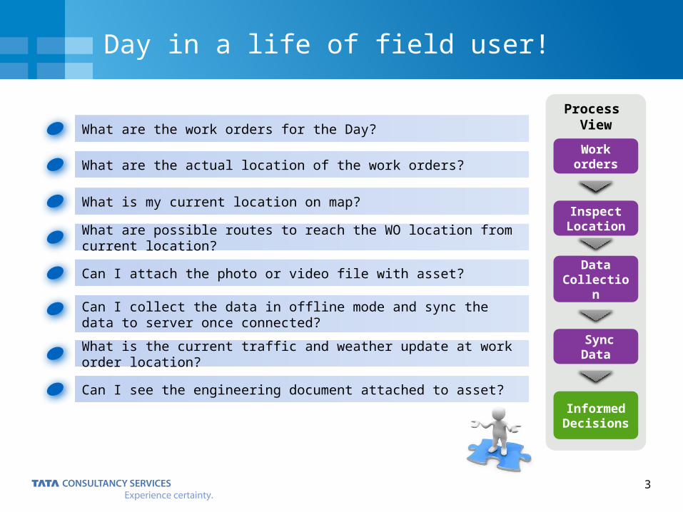
Day in a life of field user!
What are the work orders for the Day?
What are the actual location of the work orders?
What is my current location on map?
What are possible routes to reach the WO location from current location?
Can I attach the photo or video file with asset?
Can I collect the data in offline mode and sync the data to server once connected?
What is the current traffic and weather update at work order location?
Can I see the engineering document attached to asset?
Process View
Work orders
Inspect Location
Sync Data
Informed Decisions
Data Collection
4
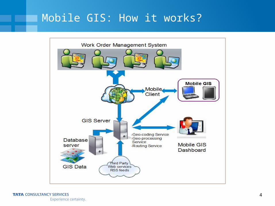
Mobile GIS: How it works?
5
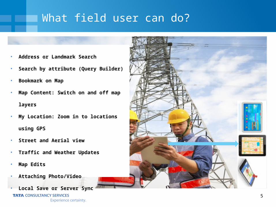
What field user can do?
• Address or Landmark Search
• Search by attribute (Query Builder)
• Bookmark on Map
• Map Content: Switch on and off map layers
• My Location: Zoom in to locations using GPS
• Street and Aerial view
• Traffic and Weather Updates
• Map Edits
• Attaching Photo/Video
• Local Save or Server Sync
6
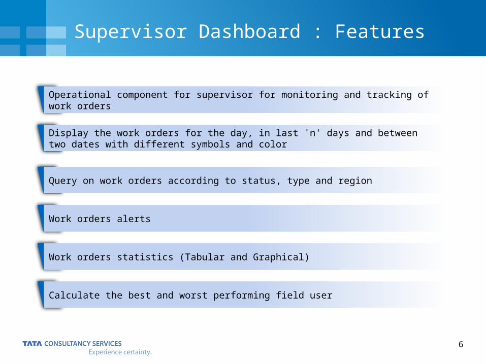
Supervisor Dashboard : Features
Operational component for supervisor for monitoring and tracking of work orders
Display the work orders for the day, in last 'n' days and between two dates with different symbols and color
Query on work orders according to status, type and region
Work orders alerts
Work orders statistics (Tabular and Graphical)
Calculate the best and worst performing field user
7
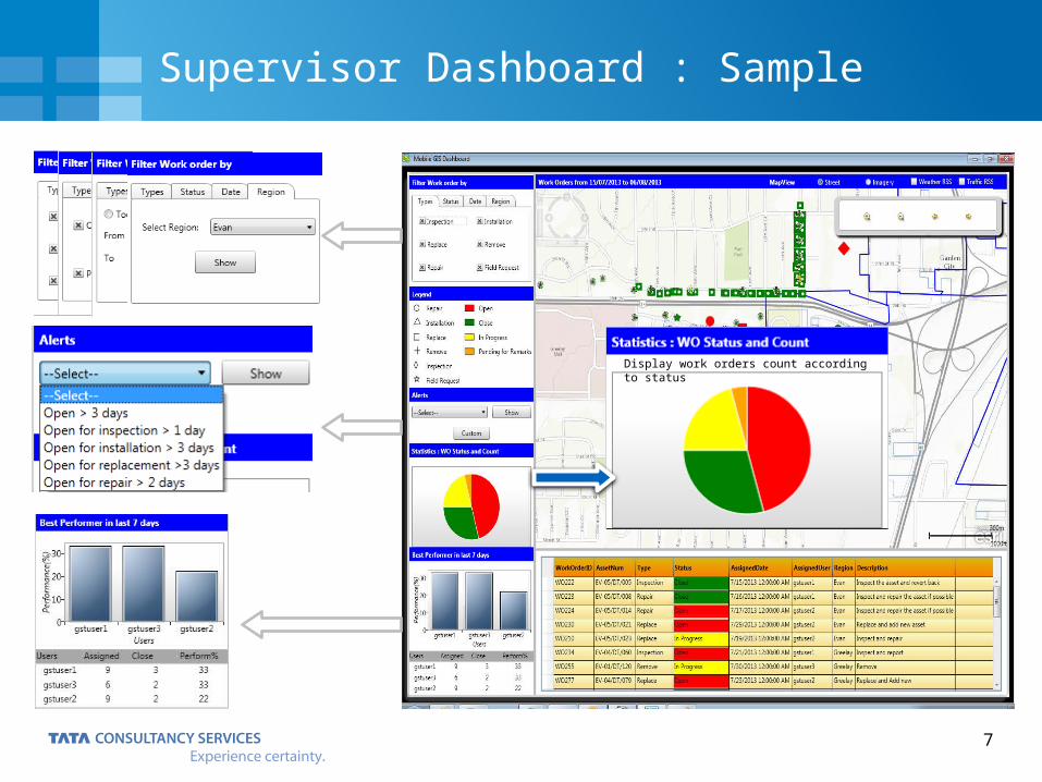
Supervisor Dashboard : Sample
Display work orders count according to status
8
Business Benefits
Lesser time to complete the tickets Rapid data collection Seamless data integration Allows field users and supervisors to make informed and timely decisions Easy workflows for non-gis field workers Online search and queries of property and asset data Supervisor can send additional task for the day after earlier assigned tasks completion Field workers can capture and reports additional/emergency problem observed to the office
Key Objectives
Flexibility to integrate with Enterprise GIS and business systems Capable to add custom functions and add new business use cases
Business Integration
Lower operational costOperational Cost
Helps resolving customer complaints faster Information on problem tickets online
Customer Satisfaction
Reduce consumption of papersEnvironmental Friendly
9
Sample Business Use Cases
Asset Inventory Asset inspection and Maintenance New Asset Installation Damage Assessment
Utilities and
Infrastructure
Asset Survey and Inspection Census data collection Health Inspection Property Survey
Government
Forest Inspection Pollution Inspection Agricultural Inspection Vacant Land Inspection
Environment

IT ServicesBusiness SolutionsConsulting
Thank You