MIUS News: Maps and Imagery User Services @ FIU Green ...
3
Florida International University FIU Digital Commons MIUS News FIU Libraries Spring 2013 MIUS News: Maps and Imagery User Services @ FIU Green Library: Vol. 4, Issue 2 Spring/Summer 2013 Mahew Toro Map and User Imagery Services, Florida International University, Mahew.Toro@fiu.edu Tiffany Selvidge Map and User Imagery Services, Florida International University Follow this and additional works at: hps://digitalcommons.fiu.edu/mius_news Part of the Geographic Information Sciences Commons , Physical and Environmental Geography Commons , and the Remote Sensing Commons is work is brought to you for free and open access by the FIU Libraries at FIU Digital Commons. It has been accepted for inclusion in MIUS News by an authorized administrator of FIU Digital Commons. For more information, please contact dcc@fiu.edu. Recommended Citation Toro, Mahew and Selvidge, Tiffany, "MIUS News: Maps and Imagery User Services @ FIU Green Library: Vol. 4, Issue 2 Spring/ Summer 2013" (2013). MIUS News. 8. hps://digitalcommons.fiu.edu/mius_news/8
Transcript of MIUS News: Maps and Imagery User Services @ FIU Green ...

Florida International UniversityFIU Digital Commons
MIUS News FIU Libraries
Spring 2013
MIUS News: Maps and Imagery User Services @FIU Green Library: Vol. 4, Issue 2 Spring/Summer2013Matthew ToroMap and User Imagery Services, Florida International University, [email protected]
Tiffany SelvidgeMap and User Imagery Services, Florida International University
Follow this and additional works at: https://digitalcommons.fiu.edu/mius_news
Part of the Geographic Information Sciences Commons, Physical and Environmental GeographyCommons, and the Remote Sensing Commons
This work is brought to you for free and open access by the FIU Libraries at FIU Digital Commons. It has been accepted for inclusion in MIUS News byan authorized administrator of FIU Digital Commons. For more information, please contact [email protected].
Recommended CitationToro, Matthew and Selvidge, Tiffany, "MIUS News: Maps and Imagery User Services @ FIU Green Library: Vol. 4, Issue 2 Spring/Summer 2013" (2013). MIUS News. 8.https://digitalcommons.fiu.edu/mius_news/8

MIUS Celebrates Launch of Newest NASA Satellite
GIS Center Tests Ground-Based LiDAR at FIU Frost Museum’s Sculpture Park
On Feb. 11, MIUS and the broader FIU community cel-ebrated the launch of NASA’s newest Earth-observation satellite, Landsat 8. Also known as the Landsat Data Con-tinuity Mission (LDCM), Landsat 8 is especially important
because it represents the next stage in the longest-run-ning series of Earth-observation satellites in the histo-ry of remote sensing, the Landsat missions. Begun in 1972, the Landsat data series is specifically designed to observe global land-covers and associated human land-uses at moderate spatial resolution. The imagery data produced through Landsat are a critical resource for professionals in fields such as agriculture, educa-tion, forestry, geography, geology, land-use / land-cov-er change, and general mapping, among others.
page 1
Recognize the scene in the image below?
It depicts a 3D models of a couple of the FIU Philip & Patri-cia Frost Museum’s sculpture pieces, part of the outdoor Sculp-ture Park at MMC. These images were produced by process-ing what are called “point clouds” derived from LiDAR (Light Detection and Ranging) laser-scanning remote sensing technol-ogy. The 3D point clouds produced by LiDAR technology have a variety of applications, ranging from archaelogy, geology, and agriculture to engineering, architecture, spaceflight, and beyond.
GIS Day 2013 Focuses on the GeoHumanitiesAnnual GIS Day celebra-tions were held at both of FIU’smain campuses, Modesto Maidique Campus (MMC) and Bis-cayne Bay Campus (BBC). Experts from fields from across the intersection of the humanities and social sciences came to share their spatially-conscious research and explorations into the blossoming transdisciplinary field of geohumanities.
New Staff
informal flows of credit and their associated debt pe-onage (socio-economic dynamics) driving the coffee industry of the Lao People’s Democratic Republic (Lao PDR). More recently, he has become heavily involved with developing geospatial methods for measuring ur-ban form (the built environment) as it relates to walk-ability. In his capacity here at FIU, Matthew coordinates activities, programs, and research between the GIS Center and the broader FIU and outside communities.
Tiffany earned her MS degree in Biology and GIS Certif-icate from the University of North Texax, after which she moved to Florida to work at FIU as the Scienes and Health
Matthew Toro and Tiffany Selvidge.
Matthew is the GIS Center’s new MIUS Coordinator / Research Associate. He earned his Master of Arts degree in Geography from the University of Miami. He is also a proud alumnus of Florida International Unviersity, where he earned his Bache-lor of Arts in Geography and International Relations. He has worked on a wide, multi-disciplinary range of projects employ-ing geospatial technologies and methodologies. Matthew’s MA thesis, for instance, looked at the relationship between land-use/land-cover change (socio-ecological dynamics) and
Over 60 guests visited the Green Library to participate in several lec-ture sessions, w o r k s h o p s , spatially-puz-zling games, a student poster c o m p e t i t i o n , and, most importantly, to discuss the power of GIS across the geohumanities and beyond. For more information about FIU’s GIS Day, see: gis.fiu.edu/gisday or gis.fiu.edu/gisdaybbc for the GIS Day activities on BBC campus.
(continued on page 2)
MIUS newsMaps & Imagery User Services @ FIU Libraries
Volume 4, Issue 2
Spring / Summer 2013
New GIS Center & Library Staff (continued from page 1)
page 2
Did you know?! MIUS Holds a Collection of Lonely Planet Guidebooks for Reference or Loan
That’s right! From Antartica to Austria, Tanzania to Turkey ...
MIUS holds an extensive collection of Lonely Plan-et guide and travel books to help with planning your next adventure or expedition, or just to research exotic lands.
Stop by GL 274 to do some in-room research. Or, you can even check-out one of these fantastic guidebooks to do some comprehensive trip planning!
The world awaits! Go ex-plore it with a Lonely Plan-et guidebook from MIUS!
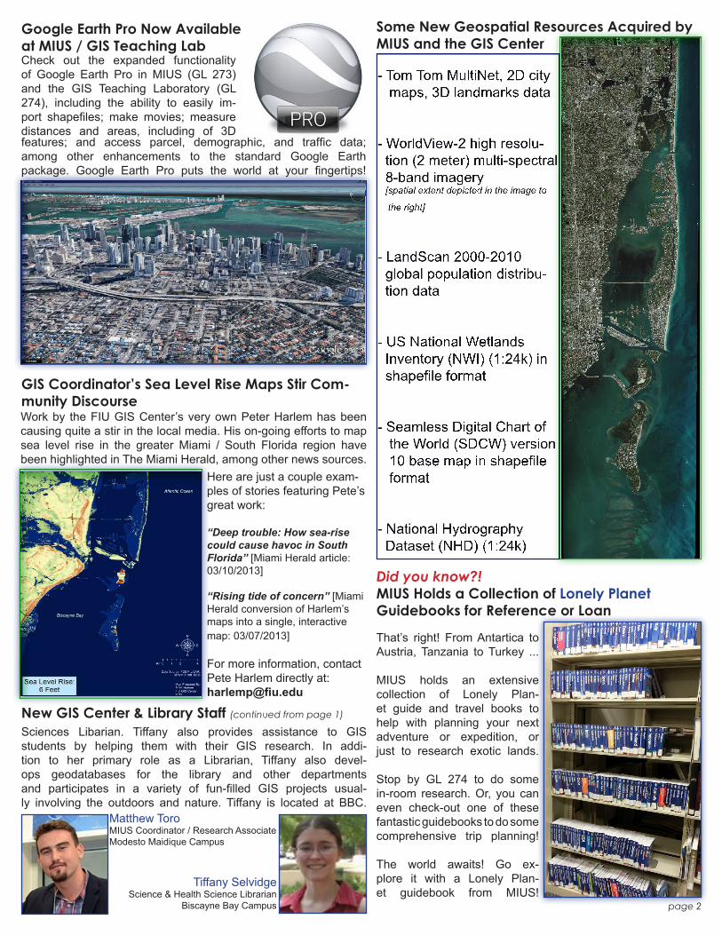
Some New Geospatial Resources Acquired by MIUS and the GIS Center
Google Earth Pro Now Available at MIUS / GIS Teaching LabCheck out the expanded functionality of Google Earth Pro in MIUS (GL 273) and the GIS Teaching Laboratory (GL 274), including the ability to easily im-port shapefiles; make movies; measure distances and areas, including of 3Dfeatures; and access parcel, demographic, and traffic data; among other enhancements to the standard Google Earth package. Google Earth Pro puts the world at your fingertips!
GIS Coordinator’s Sea Level Rise Maps Stir Com-munity DiscourseWork by the FIU GIS Center’s very own Peter Harlem has been causing quite a stir in the local media. His on-going efforts to map sea level rise in the greater Miami / South Florida region have been highlighted in The Miami Herald, among other news sources.
Here are just a couple exam-ples of stories featuring Pete’s great work:
“Deep trouble: How sea-rise could cause havoc in South Florida” [Miami Herald article: 03/10/2013]
“Rising tide of concern” [Miami Herald conversion of Harlem’s maps into a single, interactive map: 03/07/2013]
For more information, contact Pete Harlem directly at:[email protected]
Sciences Libarian. Tiffany also provides assistance to GIS students by helping them with their GIS research. In addi-tion to her primary role as a Librarian, Tiffany also devel-ops geodatabases for the library and other departments and participates in a variety of fun-filled GIS projects usual-ly involving the outdoors and nature. Tiffany is located at BBC.
Matthew ToroMIUS Coordinator / Research AssociateModesto Maidique Campus
Tiffany SelvidgeScience & Health Science Librarian
Biscayne Bay Campus