Mitigated Negative Declaration - sfmea.sfplanning.orgsfmea.sfplanning.org/2013.1407E_FMND.pdf ·...
105
www.sfplanning.org Revised 11/18/13 Mitigated Negative Declaration PMND Date: February 11, 2015 Case No.: 2013.1407E Project Title: 2501 California Street Zoning: Upper Fillmore Street Neighborhood Commercial District 40‐X Height and Bulk District Block/Lot: 0655/001, 002, and 034 Lot Size: 14,180 square feet (combined three lots) Project Sponsor: AU Energy, LLC Project Contact: Muthana Ibrahim, (925) 287‐1174 ext. 1 Lead Agency: San Francisco Planning Department Staff Contact: Tania Sheyner – (415) 575‐9127 [email protected] PROJECT DESCRIPTION: The approximately 14,180‐square‐foot (sf) project site is located on the southwest corner of the California Street/Steiner Street intersection in the Western Addition neighborhood in San Francisco. The project site currently contains a 16‐foot‐tall, approximately 1,700‐sf fueling canopy with three fuel dispensers; three underground storage tanks and associated underground pipes; and a 17‐foot‐tall, one‐story, approximately 2,200‐sf building including a convenience store and auto service station. There is one existing driveway along the project site frontage on California Street and there are two existing driveways along the project site frontage on Steiner Street. The proposed project would involve: 1) merger of the three lots into one lot; 2) the removal of all existing structures on and beneath the project site (including the fueling canopy and dispensers, underground storage tanks and associated underground pipes, and the building housing the convenience store and auto service station); and 3) the construction of a 19‐foot‐tall, approximately 2,600‐sf fueling canopy with five fueling dispensers (each dispenser containing two pumps each, one on each side); two underground storage tanks and associated underground pipes; and a structure containing an approximately 2,300‐sf convenience store on the ground level with approximately 2,300‐sf of storage space in a below‐grade basement. As part of this project, the northern driveway on Steiner Street would be eliminated and the two remaining driveways (one on California Street and one on Steiner Street) would be reduced to 28 feet in width. The project would also remove eight existing off‐street parking spaces that serve the existing uses and provide two new off‐street parking spaces, including one handicap‐accessible space. Per Planning Code Sections 102.32, 142 and 156, visual screening would be required along the perimeter of the vehicular use areas (the entire project site). The proposed project would be subject to Conditional Use Authorization by the San Francisco Planning Commission for alteration of a non‐conforming use (pursuant to Planning Code Section 186.1), lot size
Transcript of Mitigated Negative Declaration - sfmea.sfplanning.orgsfmea.sfplanning.org/2013.1407E_FMND.pdf ·...
www.sfplanning.org Revised 11/18/13
Mitigated Negative Declaration
PMND Date: February 11, 2015
Case No.: 2013.1407E
Project Title: 2501 California Street
Zoning: Upper Fillmore Street Neighborhood Commercial District
40‐X Height and Bulk District
Block/Lot: 0655/001, 002, and 034
Lot Size: 14,180 square feet (combined three lots)
Project Sponsor: AU Energy, LLC
Project Contact: Muthana Ibrahim, (925) 287‐1174 ext. 1
Lead Agency: San Francisco Planning Department
Staff Contact: Tania Sheyner – (415) 575‐9127
PROJECT DESCRIPTION:
The approximately 14,180‐square‐foot (sf) project site is located on the southwest corner of the California
Street/Steiner Street intersection in the Western Addition neighborhood in San Francisco. The project site
currently contains a 16‐foot‐tall, approximately 1,700‐sf fueling canopy with three fuel dispensers; three
underground storage tanks and associated underground pipes; and a 17‐foot‐tall, one‐story,
approximately 2,200‐sf building including a convenience store and auto service station. There is one
existing driveway along the project site frontage on California Street and there are two existing
driveways along the project site frontage on Steiner Street.
The proposed project would involve: 1) merger of the three lots into one lot; 2) the removal of all existing
structures on and beneath the project site (including the fueling canopy and dispensers, underground
storage tanks and associated underground pipes, and the building housing the convenience store and
auto service station); and 3) the construction of a 19‐foot‐tall, approximately 2,600‐sf fueling canopy with
five fueling dispensers (each dispenser containing two pumps each, one on each side); two underground
storage tanks and associated underground pipes; and a structure containing an approximately 2,300‐sf
convenience store on the ground level with approximately 2,300‐sf of storage space in a below‐grade
basement.
As part of this project, the northern driveway on Steiner Street would be eliminated and the two
remaining driveways (one on California Street and one on Steiner Street) would be reduced to 28 feet in
width. The project would also remove eight existing off‐street parking spaces that serve the existing uses
and provide two new off‐street parking spaces, including one handicap‐accessible space. Per Planning
Code Sections 102.32, 142 and 156, visual screening would be required along the perimeter of the
vehicular use areas (the entire project site).
The proposed project would be subject to Conditional Use Authorization by the San Francisco Planning
Commission for alteration of a non‐conforming use (pursuant to Planning Code Section 186.1), lot size

Mitigated Negative Declaration CASE NO. 2013.1407E 2501 California Street
(pursuant to Planning Code Section 718.11), size of the convenience store (pursuant to Planning Code
Section 718.23), hours of operation (pursuant to Planning Code Section 718.27), and automobile parking
(pursuant to Planning Code Section 718.56 The Conditional Use Authorization is identified as the Approval Action for the whole of the proposed project.
FINDING:
This project could not have a significant effect on the environment. This finding is based upon the criteria
of the Guidelines of the State Secretary for Resources, Sections 15064 (Determining Significant Effect),
15065 (Mandatory Findings of Significance), and 15070 (Decision to prepare a Negative Declaration), and the following reasons as documented in the Initial Evaluation (Initial Study) for the project, which is
attached. Mitigation measures are included in this project to avoid potentially significant effects. See
pages 91-93.
In the independent judgment of the Planning Department, there is no substantial evidence that the
project could have a significant effect on the environment.
SARAH B. JONE
Date of Issuance of Final Mitigated
Environmental Review Officer
Negative Declaration
cc: Muthana Ibrahim, Sharon Lai, M.D.F
SAN FRANCISCO 2 PLANNING DEPARTMENT

Case No. 2013.1407E i 2501 California Street
INITIAL STUDY 2501 CALIFORNIA STREET PROJECT
PLANNING DEPARTMENT CASE NUMBER 2013.1407E
TABLE OF CONTENTS A. PROJECT DESCRIPTION ............................................................................................... 1
B. PROJECT SETTING......................................................................................................... 8
C. COMPATIBILITY WITH EXISTING ZONING AND PLANS .................................. 9
D. SUMMARY OF ENVIRONMENTAL EFFECTS ....................................................... 11
E. EVALUATION OF ENVIRONMENTAL EFFECTS ................................................. 12
1. Land Use and Land Use Planning ................................................................................ 12
2. Aesthetics ......................................................................................................................... 14
3. Population and Housing ............................................................................................... 18
4. Cultural and Paleontological Resources ...................................................................... 19
5. Transportation and Circulation .................................................................................... 22
6. Noise ................................................................................................................................. 30
7. Air Quality ....................................................................................................................... 35
8. Greenhouse Gas Emissions ........................................................................................... 52
9. Wind and Shadow .......................................................................................................... 54
10. Recreation ...................................................................................................................... 56
11. Utilities and Service Systems ...................................................................................... 57
12. Public Services .............................................................................................................. 62
13. Biological Resources ..................................................................................................... 64
14. Geology and Soils ......................................................................................................... 66
15. Hydrology and Water Quality .................................................................................... 72
16. Hazards and Hazardous Materials ............................................................................ 77
17. Mineral and Energy Resources ................................................................................... 87
18. Agricultural and Forest Resources ............................................................................. 89
19. Mandatory Findings of Significance .......................................................................... 90
F. MITIGATION MEASURES AND IMPROVEMENT MEASURES ......................... 91
G. PUBLIC NOTICE AND COMMENT .......................................................................... 93
H. DETERMINATION ....................................................................................................... 95
I. INITIAL STUDY PREPARERS .................................................................................... 96
LIST OF FIGURES
Figure 1. Project Location Map ................................................................................................... 2
Figure 2. Existing Site Plan .......................................................................................................... 3
Figure 3. Proposed Site Plan ....................................................................................................... 4
Case No. 2013.1407E ii 2501 California Street
Figure 4. Proposed Floor Plans ................................................................................................... 5
Figure 5. Proposed Elevations .................................................................................................... 6
LIST OF TABLES
Table 1. Typical Commercial Construction Noise Levels (dBA) ......................................... 34
Table 2. Criteria Air Pollutant Significance Thresholds ........................................................ 37
Case No. 2013.1407E 2501 California Street
1
INITIAL STUDY 2501 CALIFORNIA STREET
PLANNING DEPARTMENT CASE NUMBER 2013.1407E
A. PROJECT DESCRIPTION
Project Location and Site Characteristics
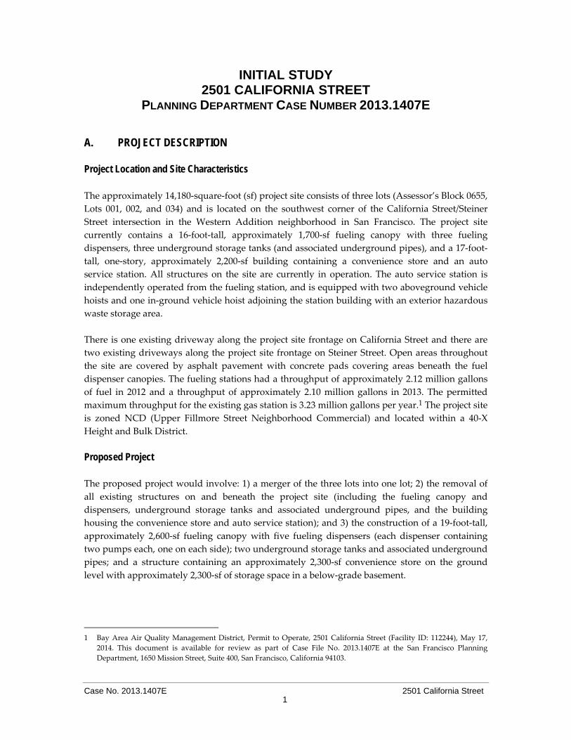
The approximately 14,180‐square‐foot (sf) project site consists of three lots (Assessor’s Block 0655,
Lots 001, 002, and 034) and is located on the southwest corner of the California Street/Steiner
Street intersection in the Western Addition neighborhood in San Francisco. The project site
currently contains a 16‐foot‐tall, approximately 1,700‐sf fueling canopy with three fueling
dispensers, three underground storage tanks (and associated underground pipes), and a 17‐foot‐
tall, one‐story, approximately 2,200‐sf building containing a convenience store and an auto
service station. All structures on the site are currently in operation. The auto service station is
independently operated from the fueling station, and is equipped with two aboveground vehicle
hoists and one in‐ground vehicle hoist adjoining the station building with an exterior hazardous
waste storage area.
There is one existing driveway along the project site frontage on California Street and there are
two existing driveways along the project site frontage on Steiner Street. Open areas throughout
the site are covered by asphalt pavement with concrete pads covering areas beneath the fuel
dispenser canopies. The fueling stations had a throughput of approximately 2.12 million gallons
of fuel in 2012 and a throughput of approximately 2.10 million gallons in 2013. The permitted
maximum throughput for the existing gas station is 3.23 million gallons per year.1 The project site
is zoned NCD (Upper Fillmore Street Neighborhood Commercial) and located within a 40‐X
Height and Bulk District.
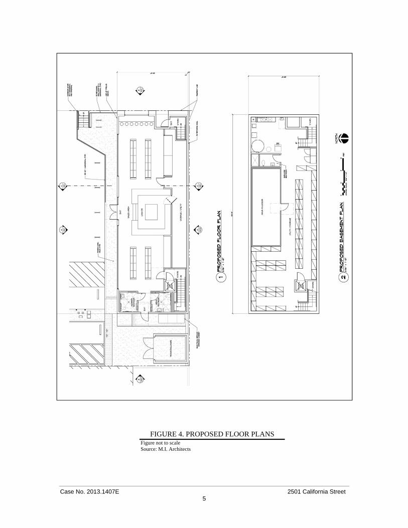
Proposed Project The proposed project would involve: 1) a merger of the three lots into one lot; 2) the removal of
all existing structures on and beneath the project site (including the fueling canopy and
dispensers, underground storage tanks and associated underground pipes, and the building
housing the convenience store and auto service station); and 3) the construction of a 19‐foot‐tall,
approximately 2,600‐sf fueling canopy with five fueling dispensers (each dispenser containing
two pumps each, one on each side); two underground storage tanks and associated underground
pipes; and a structure containing an approximately 2,300‐sf convenience store on the ground
level with approximately 2,300‐sf of storage space in a below‐grade basement.
1 Bay Area Air Quality Management District, Permit to Operate, 2501 California Street (Facility ID: 112244), May 17,
2014. This document is available for review as part of Case File No. 2013.1407E at the San Francisco Planning
Department, 1650 Mission Street, Suite 400, San Francisco, California 94103.
Case No. 2013.1407E 2501 California Street 2
FIGURE 1. PROJECT LOCATION MAP Figure not to scale Source: San Francisco Planning Department

Case No. 2013.1407E 2501 California Street 3
FIGURE 2. EXISTING SITE PLAN Figure not to scale Source: M.I. Architects

Case No. 2013.1407E 2501 California Street 4
FIGURE 3. PROPOSED SITE PLAN Figure not to scale Source: M.I. Architects
Case No. 2013.1407E 2501 California Street 5
FIGURE 4. PROPOSED FLOOR PLANS Figure not to scale Source: M.I. Architects
Case No. 2013.1407E 2501 California Street 6
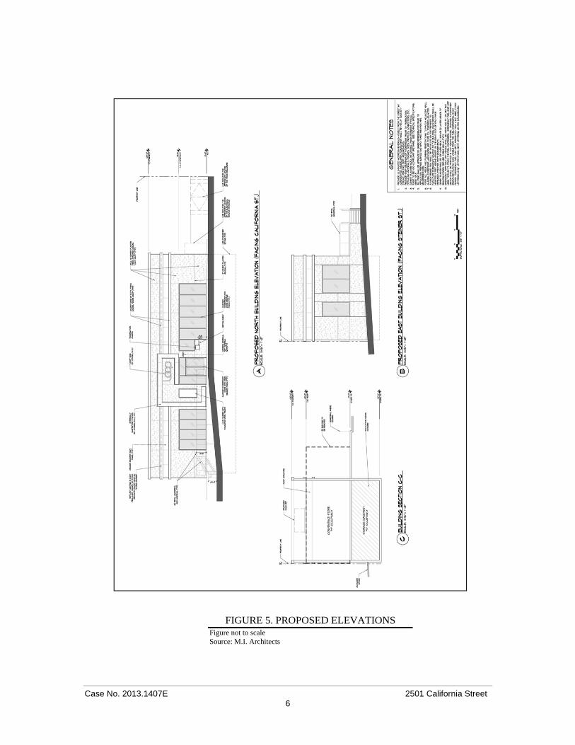
FIGURE 5. PROPOSED ELEVATIONS Figure not to scale Source: M.I. Architects

Case No. 2013.1407E 2501 California Street 7
The future throughput at the fueling service station is unknown; however, the project sponsor
has indicated that it would not exceed the throughput limit specified in the existing BAAQMD
Permit to Operate, which permits a throughput of 3.23 million gallons per year (which is defined
in the permit as any consecutive 12‐month period).2 The proposed convenience store would sell
mostly pre‐packaged food items, sundry items, automobile accessories, self‐service beverages
and the like. No cooking or food preparation would occur on the premises. The fuel delivery for
the station would be via a tanker truck and would occur five time times per week, while truck
deliveries to the convenience store would occur once per week.
As noted above, there is one existing driveway along the project site frontage on California Street
(approximately 31 feet in width) and there are two existing driveways along the project site
frontage on Steiner Street (both approximately 33 feet in width). As part of this project, the
northern driveway on Steiner Street would be eliminated and the two remaining driveways (one
on California Street and one on Steiner Street) would be reduced to 28 feet in width. The project
would also remove eight existing off‐street parking spaces that serve the existing uses and
provide two new off‐street parking spaces, including one handicap‐accessible space. The project
would also provide six bicycle racks that would be able to accommodate parking for up to 12
bicycles. In addition, landscaping and seating would be installed at the California/Steiner Streets
corner of the project site (this work would be subject to Public Works review and approval).
Visual screening would be provided along the perimeter of the vehicular use areas (the project
site). The proposed project would involve excavation up to a depth of 10 feet below grade and
removal of approximately 1,200 cubic yards of soil. The proposed fueling station and convenience
store would operate 24 hours per day, 7 days per week (as under existing conditions) and would
employ a total of approximately 14 full‐time employees and 12 part‐time employees.
Project construction is anticipated to begin mid‐2015, would last approximately 6 months and is
estimated to cost approximately 2 million dollars.
Project Approvals
The project would require the following project approvals:
Conditional Use Authorization by the San Francisco Planning Commission would be
required for alteration of a non‐conforming use (pursuant to Planning Code Section
186.1), lot size (pursuant to Planning Code Section 718.11), size of the convenience store
(pursuant to Planning Code Section 718.23), hours of operation (pursuant to Planning
Code Section 718.27), and automobile parking (pursuant to Planning Code Section
718.56).
Street Tree Permit, Grading Permit, and Right‐of‐Way Permit from the Department of
Public Works (DPW);
Building Permits from the Department of Building Inspection (DBI); and
2 Muthana Ibrahim, MI Architects, Project Sponsor. Email to Tania Sheyner, San Francisco Planning Department, 2501
California Street, September 16, 2014. This email is available for review as part of Case File No. 2013.1407E at the San
Francisco Planning Department, 1650 Mission Street, Suite 400, San Francisco, California 94103.

Case No. 2013.1407E 2501 California Street 8
A Site Mitigation Plan (SMP) for review and approval by the San Francisco Department
of Public Health (SFDPH) prior to the commencement of any excavation work.
Approval Action: Approval of the Conditional Use Authorization by the San Francisco Planning
Commission is the Approval Action for the proposed project for the purposes of a CEQA appeal.
The Approval Action date would establish the start of the 30‐day appeal period for appeal of the
Final Negative Declaration to the Board of Supervisors pursuant to Section 31.04(h) of the San
Francisco Administrative Code.
B. PROJECT SETTING
The project site is located on the southwest corner of California and Steiner Streets on the block
bounded by California Street to the north, Steiner Street to the east, Pine Street to the south and
Pierce Street to the west, within the Western Addition Neighborhood of San Francisco. As noted
above, the project site is zoned Fillmore Street NCD and is located within a 40‐X Height and Bulk
District. The eastern half of the project block, as well as some of the adjoining lots to the north,
northeast, and east, are also zoned NCD. The western half of the project block is zoned RH‐2
(Residential, House, Two‐Family).
Land uses in the vicinity of the project site are dominated by multi‐family residential and
neighborhood commercial uses interspersed with institutional uses and a surface parking lot.
Residential buildings in the project vicinity are generally three to four stories and approximately
30 to 40 feet in height, while commercial and other uses vary in height and bulk pattern. Directly
north of the project site, across California Street, is another fueling station. East of the project site,
across Steiner Street, is a grocery store, Mollie Stone’s, which contains a large surface parking lot.
At the northeast corner of the intersection of California and Steiner Streets are residential uses
and a surface parking lot. The project block is dominated by residential uses and also contains a
medical offices building on the corner of Steiner and Pine Streets (according to the Planning
Department’s land use records). There is a bicycle route near the project site, Route 45 (Class III)
along Steiner Street.
C. COMPATIBILITY WITH EXISTING ZONING AND PLANS
Applicable Not Applicable
Discuss any variances, special authorizations, or changes proposed to the Planning Code or Zoning Map, if applicable.
Discuss any conflicts with any adopted plans and goals of the City or Region, if applicable.
Discuss any approvals and/or permits from City departments other than the Planning Department or the Department of Building Inspection, or from Regional, State, or Federal Agencies.
San Francisco Planning Code The San Francisco Planning Code (“Planning Code”), which incorporates by reference the City’s
Zoning Maps, governs permitted uses, densities and the configuration of buildings within San

Case No. 2013.1407E 2501 California Street 9
Francisco. Permits to construct new buildings (or to alter or demolish existing ones) may not be
issued unless either the proposed project conforms to the Planning Code, or an exception is
granted pursuant to provisions of the Planning Code. The project site is within the Upper
Fillmore NCD and in a 40‐X Height and Bulk District
Allowable Uses Planning Code Section 718.1 states that the intent of the Upper Fillmore NCD is, “…to protect the
existing building scale and promote new mixed‐use development which is in character with
adjacent buildings.…Most commercial uses are permitted at the first two stories of new
buildings. Special controls are designed to preserve the existing equilibrium of neighborhood‐
serving convenience and specialty commercial uses. In order to maintain convenience stores and
protect adjacent livability, additional bars (unless part of a full‐service restaurant) and formula
retail establishments are prohibited, other eating and drinking establishments and self‐service
specialty foods require conditional use authorization and ground‐story entertainment and
financial service uses are limited. In order to promote continuous retail frontage, drive‐up and
most automobile uses are prohibited.”
Planning Code Section 228, however, states that automobile service stations are considered
essential services and their conversion to other uses is “contrary to the public health, safety, peace
and general welfare.” Therefore, the Board of Supervisors recognizes that service station
operators and those who own property on which such stations are located are entitled to earn a
fair rate of return on their investment. Where a fair rate of return is being earned, the Board finds
that service stations should be allowed to convert to other uses only where it is determined that
the conversion would benefit the public.
Moreover, Planning Code Section 181 allows some non‐conforming uses to continue, provided
that they meet the various requirements specified in that section, including that such uses shall
not be enlarged, intensified, extended, or moved to another location. Since the proposed project
would not expand beyond the boundaries of the existing project site, the project would meet the
requirements of this Planning Code section and this project would be considered an allowable
use on the site.
The proposed uses would include a fueling canopy with five fueling dispensers, two
underground storage tanks and associated underground pipes, and a building containing a 2,300‐
sf convenience store on the ground level with approximately 2,300‐sf of storage space in a below‐
grade basement. Since these uses would continue the existing uses on the project site, they would
be permitted within the Upper Fillmore NCD. However, the proposed project would be subject
to several Conditional Use authorizations, as discussed above. Thus, an official determination
regarding the project’s consistency with the Planning Code would be made by the Planning
Department when it reviews the proposed uses for conformance with all applicable zoning
requirements as part of the building permit review process for the proposed project, a process
separate from the environmental review.
Case No. 2013.1407E 2501 California Street 10
Height and Bulk The project site is located in a 40‐X Height and Bulk District. Pursuant to Article 2.5 of the
Planning Code, this district allows a maximum building height of 40 feet, and does not impose
limits on building bulk. The proposed convenience store/storage building would be 20 feet in
height to the top of the parapet. Thus, the proposed project complies with both the height and
bulk limits applicable to the project site.
Plans and Policies San Francisco Plans and Policies
San Francisco General Plan The San Francisco General Plan provides general policies and objectives to guide land use
decisions. The General Plan contains 10 elements (Commerce and Industry, Recreation and Open
Space, Housing, Community Facilities, Urban Design, Environmental Protection, Transportation,
Air Quality, Community Safety, and Arts) that set forth goals, policies, and objectives for the
physical development of the City. The proposed project would not obviously or substantially
conflict with any General Plan goals, policies, or objectives. The compatibility of the proposed
project with General Plan goals, policies, and objectives that do not relate to physical
environmental issues will be considered by decision‐makers as part of their decision whether to
approve or disapprove the proposed project. Any potential conflicts identified as part of the
process would not alter the physical environmental effects of the project.
Proposition M – The Accountable Planning Initiative In November 1986, the voters of San Francisco approved Proposition M, the Accountable
Planning Initiative, which added Section 101.1 to the Planning Code to establish eight Priority
Policies. These policies, and the subsection of Section E of this Initial Study addressing the
environmental issues associated with the policies, are: (1) preservation and enhancement of
neighborhood‐serving retail uses; (2) protection of neighborhood character (Topic 1, Land Use
and Land Use Planning, Question 1c); (3) preservation and enhancement of affordable housing
(Topic 3, Population and Housing, Question 3b, with regard to housing supply and displacement
issues); (4) discouragement of commuter automobiles (Topic 5, Transportation and Circulation,
Questions 5a, 5b, and 5f); (5) protection of industrial and service land uses from commercial office
development and enhancement of resident employment and business ownership (Topic 1, Land
Use and Land Use Planning, Question 1c); (6) maximization of earthquake preparedness (Topic
14, Geology and Soils, Questions 14a through 14d); (7) landmark and historic building
preservation (Topic 4, Cultural Resources, Question 4a); and (8) protection of open space (Topic
9, Wind and Shadow, Questions 9a and 9b; and Topic 10, Recreation, Questions 10a and 10c).
Prior to issuing a permit for any project which requires an Initial Study under the California
Environmental Quality Act (CEQA), prior to issuing a permit for any demolition, conversion, or
change of use, and prior to taking any action that requires a finding of consistency with the
General Plan, the City is required to find that the proposed project or legislation would be
consistent with the Priority Policies. As noted above, the consistency of the proposed project with
the environmental topics associated with the Priority Policies is discussed in Section E,
Case No. 2013.1407E 2501 California Street 11
Evaluation of Environmental Effects, of this Initial Study, providing information for use in the
approvals for the proposed project.
Regional Plans and Policies The five principal regional planning agencies and their policy documents that guide planning in
the nine‐county Bay Area are the Association for Bay Area Governments (ABAG) projections
2009, the Bay Area Air Quality Management District (BAAQMD) 2010 Clean Air Plan, the
Metropolitan Transportation Commission (MTIC) Regional Transportation Plan – Transportation
2035, the San Francisco Regional Water Quality Control Board (RWQCB) San Francisco Basin
Plan, and the San Francisco Bay Conservation and Development Commission (BCDC) San
Francisco Bay Plan. Due to the size and nature of the proposed project, there would be no
anticipated conflicts with regional plans. D. SUMMARY OF ENVIRONMENTAL EFFECTS The proposed project could potentially affect the environmental factor(s) checked below. The
following pages present a more detailed checklist and discussion of each environmental factor.
Land Use Air Quality Biological Resources
Aesthetics Greenhouse Gas
Emissions Geology and Soils
Population and Housing Wind and Shadow Hydrology and Water
Quality
Cultural and Paleo.
Resources Recreation
Hazards/Hazardous
Materials
Transportation and
Circulation
Utilities and Service
Systems Mineral/Energy Resources
Noise Public Services Agricultural and Forest
Resources
Mandatory Findings of
Significance
This Initial Study examines the proposed project to identify potential effects on the environment.
For each item on the Initial Study Checklist, the evaluation has considered the impacts of the
proposed project both individually and cumulatively. All items on the Initial Study Checklist that
have been checked “Less than Significant with Mitigation Incorporated,“ “Less than Significant
Impact,” “No Impact,” or “Not Applicable” indicate that, upon evaluation, staff has determined
that the proposed project could not have a significant adverse environmental effect relating to
that issue. A discussion is included for those items checked “Less than Significant with
Mitigation Incorporated” and “Less than Significant Impact” and for most items checked “No
Impact” or “Not Applicable.” For all of the items checked “No Impact” or “Not Applicable”
without discussion, the conclusions regarding potential significant adverse environmental effects
are based upon field observation, staff experience and expertise on similar projects, and/or
standard reference material available within the Planning Department, such as the Department’s
Transportation Impact Analysis Guidelines for Environmental Review, or the California Natural
Case No. 2013.1407E 2501 California Street 12
Diversity Database and maps, published by the California Department of Fish and Game. For
each checklist item, the evaluation has considered the impacts of the proposed project, both
individually and cumulatively. The items checked above have been determined to be “Less than
Significant with Mitigation Incorporated.”
E. EVALUATION OF ENVIRONMENTAL EFFECTS
Topics:
Potentially Significant
Impact
Less Than Significant
with Mitigation
Incorporated
Less Than Significant
Impact No
Impact Not
Applicable
1. LAND USE AND LAND USE PLANNING ‐
Would the project:
a) Physically divide an established community?
b) Conflict with any applicable land use plan,
policy, or regulation of an agency with
jurisdiction over the project (including, but not
limited to the general plan, specific plan, local
coastal program, or zoning ordinance) adopted
for the purpose of avoiding or mitigating an
environmental effect?
c) Have a substantial impact upon the existing
character of the vicinity?
Impact LU‐1: The proposed project would not physically divide an established community.
(Less than Significant)
Land use impacts are considered significant if they disrupt or divide the physical arrangement of
an established community, or if they have a substantial impact on the existing character of the
vicinity. The project site currently contains a 16‐foot‐tall, approximately 1,700‐sf fueling canopy
with three fueling dispensers, three underground storage tanks (and associated underground
pipes), and a one‐story, approximately 2,200‐sf building containing a convenience store and an
auto service station. The proposed project includes the removal of all existing above‐ and below‐
ground structures on the site and construction of a 19‐foot‐tall, 2,600‐sf fueling canopy with five
fueling dispensers, two underground storage tanks (and associated underground pipes), and a
one‐story structure containing an approximately 2,300‐sf convenience store with approximately
2,300‐sf of storage space in a below‐grade basements. The proposed project would continue the
existing uses on the site and would not extend beyond the boundaries of the project site.
Therefore, the proposed project would not divide any established community and would not
result in a significant land use impact.
Land uses in the vicinity of the project site are dominated by residential, commercial, and
institutional uses. These surrounding uses would be expected to continue their operation and to
relate to each other as they do presently, without disruption from the proposed project. Because
the proposed building would be constructed within the existing lot configuration, the project

Case No. 2013.1407E 2501 California Street 13
would not physically divide or interfere with the arrangement of existing uses and activities that
surround it or alter the existing street plan. The proposed project would also not impede the
passage of persons or vehicles. The surrounding uses and activities would remain and they
would interrelate with each other as they do at present. They would not be affected substantially
by the proposed project.
Impact LU‐2: The proposed project would be consistent with applicable land use plans,
policies, or regulations of an agency with jurisdiction over the project adopted for the purpose
of avoiding or mitigating an environmental effect. (Less than Significant)
Land use impacts are considered to be significant if the proposed project would conflict with any
plan, policy, or regulation adopted for the purpose of avoiding or mitigating an environmental
effect. Environmental plans and policies are those, like the Bay Area Air Quality Management
District (BAAQMD) 2010 Clean Air Plan, which directly address environmental issues and/or
contain targets or standards, which must be met in order to preserve or improve characteristics of
the City’s physical environment.
The proposed project would not obviously or substantially conflict with applicable plans,
policies, and regulations such that an adverse physical change would result. Therefore, the
proposed project would have a less‐than‐significant impact with regard to conflicts with existing
plans and zoning.
Impact LU‐3: The proposed project would not have a substantial impact upon the existing
character of the project vicinity. (Less than Significant)
The vicinity of the project site primarily contains one‐ to four‐story residential, commercial and
institutional buildings ranging from approximately 15 feet to approximately 35 feet in height. The
proposed project would construct a 19‐foot‐tall, approximately 2,600‐sf fueling canopy with five
fueling dispensers, two underground storage tanks and associated underground pipes, and a 20‐
foot‐tall structure containing an approximately 2,300‐sf convenience store on the ground level
with approximately 2,300‐sf of storage space in a below‐grade basement. These proposed uses
would be generally compatible with the existing land uses in the vicinity of the site. Another
fueling station exists in proximity of the project site (across California Street) and the siting of
such uses among residential and commercial uses is common throughout the city and is not
considered incompatible. Moreover, the project would not constitute a change in land use, since a
fueling station and a convenience store already exist on the project site. Although the project may
increase and intensify these uses somewhat, such increase/intensification would not be
substantial enough to result in a significant impact.
Land use impacts are considered to be significant if the proposed project would have a
substantial impact upon the existing character of the vicinity. The proposed building would be
similar in scale to other existing buildings on the project block and would be consistent with the
physical character of the area. Based on this and the discussion above, the proposed project’s
impact on the existing character of the project’s vicinity would be less than significant.

Case No. 2013.1407E 2501 California Street 14
Impact C‐LU‐1: The proposed project would not make a considerable contribution to any
cumulative significant land use impacts. (Less than Significant)
As of August 2014, there are no active Planning Department cases or active building permits on
the project block. There are a number of active building permits within a quarter mile of the
project site. These permits include such activities as seismic retrofits and ADA improvements at
2390 Bush Street, replacement of an existing driveway and reroofing at 2210 Pine Street,
emergency reinforcement work to stabilize existing front facade at 2178 Pine Street. Given the
nature and scope of these projects and the distance from the project site, none of the above
projects could interact with the proposed project to result in cumulative adverse land use
impacts.
For the reasons above, the proposed project’s impacts related to land use, both individually and
cumulatively, would be less than significant.
Topics:
Potentially Significant
Impact
Less Than Significant
with Mitigation
Incorporated
Less Than Significant
Impact No
Impact Not
Applicable
2. AESTHETICS —Would the project:
a) Have a substantial adverse effect on a scenic
vista?
b) Substantially damage scenic resources,
including, but not limited to, trees, rock
outcroppings, and other features of the built or
natural environment which contribute to a scenic
public setting?
c) Substantially degrade the existing visual
character or quality of the site and its
surroundings?
d) Create a new source of substantial light or glare
which would adversely affect day or nighttime
views in the area or which would substantially
impact other people or properties?
A visual quality/aesthetics analysis is somewhat subjective and considers the project in relation to
the surrounding visual character, heights and building types of surrounding uses, its potential to
obstruct scenic views or vistas, and its potential for light and glare. The proposed project’s
specific design would be considered to have a significant adverse environmental effect on visual
quality only if it would cause a substantial and demonstrative negative change.
Impact AE‐1: The proposed project would not have a substantial adverse effect on scenic
vistas. (Less than Significant)
Case No. 2013.1407E 2501 California Street 15
The project site is located on the corner of California and Steiner Streets, which is within a mixed‐
use commercial/residential neighborhood that contains a variety of building styles, styles and
sizes. The proposed project would demolish the existing structure on the project site and
construct a 19‐foot‐tall, approximately 2,600‐sf fueling canopy with five fueling dispensers, two
underground storage tanks and associated underground pipes, and a 20‐foot‐tall structure
containing an approximately 2,300‐sf convenience store on the ground level with approximately
2,300‐sf of storage space in a below‐grade basement. The proposed structures would be visible
from nearby streets, including, California and Steiner Streets, and may also be visible from
several public open spaces, such as the elevated portion of Alta Plaza, located two blocks north of
the project site.
A project would have a significant effect on scenic vistas if it would substantially degrade
important public view corridors and obstruct scenic views from public areas viewable by a
substantial number of people. View corridors are defined by physical elements such as buildings
and structures that direct lines of sight and control view directions available to the public. The
streets abutting the project site are categorized as “Average” or “Good” in the San Francisco
General Plan’s Quality of Street Views map. Given the developed nature of the surrounding
blocks, it is unlikely that the project site is visible from many public open spaces in the area. As
noted above, it is possible, however, that the project site is visible from the elevated portion of
Alta Plaza two blocks to the north. Regardless, even if visible from this public open space and
others in the area, the proposed project is unlikely to interrupt any view corridors from these
vantage points, since the proposed project would not exceed the scale of other buildings on the
subject block, which range in height from two to four stories. The height of the proposed
structures would be approximately the same as height of a typical two‐story building. Moreover,
the proposed project would replace an existing fueling station on the project site; thus, with
project implementation, the project site would appear similar in views to existing conditions
(albeit more modern and perhaps slightly larger). The proposed structures on the project site
would be noticeable, but would not substantially alter scenic vistas or degrade or obstruct any
publicly accessible scenic views. Moreover, the project would not be out of scale with the
surrounding buildings and would not degrade the area’s visual setting.
Project construction would occur over six months. Although construction activities would
diminish the existing visual character of the project site, these activities would be limited in
duration. Therefore, the proposed project’s construction would not have a significant impact on
the existing visual character or quality of the site or its surroundings.
Changes to private views would differ based on proximity to the project site, quality of the view
currently experienced, and relative sensitivity of the viewer. Therefore, the proposed projectʹs
impact on scenic vistas would be less than significant. Although some reduced private views
would be an unavoidable consequence of the proposed project, any change in private views
would not exceed that commonly accepted in an urban setting. While this loss or change of views
might be of concern to those property owners or tenants, it would not affect a substantial number
of people and would not rise to a level considered to be a significant impact on the environment.

Case No. 2013.1407E 2501 California Street 16
The proposed project would not substantially impact any existing public views or view corridors
in the area, and the adverse effect upon private views would not be considered a significant
impact on the environment, pursuant to CEQA.
Impact AE‐2: The proposed project would not substantially damage any scenic resources
which contribute to a scenic public setting. (Less than Significant)
Scenic resources are the visible physical features on a landscape (e.g., land, water, vegetation,
animals, structures, or other features) which contribute to a scenic public setting. There are no
trees and limited vegetation on the site. As part of the proposed project, five street trees would be
planted along Steiner Street and one street tree would be planted along California Street. In
addition, landscaping and seating would be installed at the California/Steiner Streets corner of
the project site (this work would be subject to Public Works review and approval). Therefore, the
proposed project’s impact on scenic resources would be less than significant.
Impact AE‐3: The proposed project would not result in a change to the existing visual character
of the project site or substantially degrade the visual character or quality of the site and its
surroundings. (Less than Significant)
A project would have a significant adverse effect on visual quality under CEQA only if it would
cause a substantial and demonstrable negative change to the project site or its surroundings. The
existing visual character of the project site and vicinity is that of a mixed‐use neighborhood. Land
uses in the vicinity of the project site are dominated by multi‐family residential and
neighborhood commercial uses interspersed with institutional uses and a surface parking lot.
Residential buildings in the project vicinity are generally three to four stories and approximately
30 to 40 feet in height, while commercial and other uses vary in height and bulk pattern. The
proposed project would construct a 19‐foot‐tall, approximately 2,600‐sf fueling canopy with five
fueling dispensers, two underground storage tanks and associated underground pipes, and a 20‐
foot‐tall structure containing an approximately 2,300‐sf convenience store on the ground level
with approximately 2,300‐sf of storage space in a below‐grade basement.
The proposed convenience store would be situated along the south property line, with entrances
along its eastern (Steiner Street) and northern facades. The north façade would be clad in cement
plaster finish, punctuated by aluminum storefront windows and doors and accented by
horizontal bands. A metal guardrail would extend from Steiner Street to the entrance doors. The
proposed fueling canopy would be characterized by a flat panel held up by columns (similar to
the existing fueling canopy on the site). The implementation of the proposed project may be
noticeable; however, the project would replace similar structures that already exist on the project
site. Thus, the proposed project would not be expected to substantially alter the existing visual
character of the site or its surroundings in a demonstrably adverse manner. Moreover, the
proposed project would not exceed the scale of other buildings on the subject block, which range
in height from two to four stories. For the above reasons, this impact would be less than
significant.
Project construction would occur over six months. Although construction activities would
diminish the existing visual character of the project site, these activities would be limited in

Case No. 2013.1407E 2501 California Street 17
duration. Therefore, the proposed project’s construction would not result in a substantial
degradation of the existing visual character or quality of the site or its surroundings.
Impact AE‐4: The proposed project would not create a new source of light and glare, and
would not be expected to adversely affect daytime or nighttime views in the area. (Less than
Significant)
The proposed project would construct a 19‐foot‐tall, approximately 2,600‐sf fueling canopy with
five fueling dispensers, two underground storage tanks and associated underground pipes, and a
20‐foot‐tall structure containing an approximately 2,300‐sf convenience store on the ground level
with approximately 2,300‐sf of storage space in a below‐grade basement. The proposed project
would comply with Planning Commission Resolution 9212 (1981) that establishes guidelines
aimed at limiting glare from buildings. As such, the proposed project would result in minimal
sources of light and glare beyond what currently exists (illumination from the existing fueling
station structures on the project site as well as existing street lights and lighting related to the
surrounding buildings). Because the proposed project would comply with Planning Commission
Resolution 9212 and would minimally increase the amount of lighting on the project site, it
would not have a substantial, negative impact. Based on the above analysis, impacts associated
with light and glare would be less than significant.
Impact C‐AE‐1: The proposed project, in combination with past, present, and reasonably
foreseeable future projects in the vicinity, would not have a substantial adverse cumulative
impact to aesthetics. (Less than Significant)
Implementation of the proposed project, in combination with the cumulative projects described
above in Section E.1, Land Use and Land Use Planning, would result in minimal change to the
visual character of the project site vicinity and respective project site. As discussed above, under
Impact C‐LU‐1, as of August 2014, there are no active Planning Department cases or active
building permits on the project block. There are a number of active building permits within a
quarter mile of the project site. These permits include such activities as seismic retrofits and ADA
improvements at 2390 Bush Street, replacement of an existing driveway and reroofing at 2210
Pine Street, emergency reinforcement work to stabilize existing front facade at 2178 Pine Street.
Based on the discussions above, the proposed project would not be expected to have a substantial
adverse cumulative effect on a scenic vista, scenic resource, or existing visual character or quality
of the site and its surroundings. For these reasons, the proposed project, in combination with
other past, present, and reasonably foreseeable future projects, would not result in a cumulatively
considerable aesthetics impact.
Case No. 2013.1407E 2501 California Street 18
Topics:
Potentially Significant
Impact
Less Than Significant
with Mitigation
Incorporated
Less Than Significant
Impact No
Impact Not
Applicable
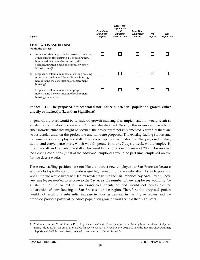
3. POPULATION AND HOUSING—
Would the project:
a) Induce substantial population growth in an area,
either directly (for example, by proposing new
homes and businesses) or indirectly (for
example, through extension of roads or other
infrastructure)?
b) Displace substantial numbers of existing housing
units or create demand for additional housing,
necessitating the construction of replacement
housing?
c) Displace substantial numbers of people,
necessitating the construction of replacement
housing elsewhere?
Impact PH‐1: The proposed project would not induce substantial population growth either
directly or indirectly. (Less than Significant)
In general, a project would be considered growth inducing if its implementation would result in
substantial population increases and/or new development through the extension of roads or
other infrastructure that might not occur if the project were not implemented. Currently there are
no residential units on the project site and none are proposed. The existing fueling station and
convenience store employ six staff. The project sponsor estimates that the proposed fueling
station and convenience store, which would operate 24 hours, 7 days a week, would employ 14
full‐time staff and 12 part‐time staff.3 This would constitute a net increase of 20 employees over
the existing conditions (most of the additional employees would be part‐time, employed on site
for two days a week).
These new staffing positions are not likely to attract new employees to San Francisco because
service jobs typically do not provide wages high enough to induce relocation. As such, potential
jobs at the site would likely be filled by residents within the San Francisco Bay Area. Even if these
new employees needed to relocate to the Bay Area, the number of new employees would not be
substantial in the context of San Francisco’s population and would not necessitate the
construction of new housing in San Francisco or the region. Therefore, the proposed project
would not result in a substantial increase in housing demand in the City or region, and the
proposed project’s potential to induce population growth would be less than significant.
3 Muthana Ibrahim, MI Architects, Project Sponsor. Email to Kei Zushi, San Francisco Planning Department, 2501 California
Street, July 8, 2014. This email is available for review as part of Case File No. 2013.1407E at the San Francisco Planning
Department, 1650 Mission Street, Suite 400, San Francisco, California 94103.

Case No. 2013.1407E 2501 California Street 19
Impact PH‐2: The proposed project would not displace housing units or displace a substantial
number of people necessitating the construction of replacement housing elsewhere. (No
Impact)
As noted above, the project site currently operates as a fueling station, auto service station, and a
convenience store, and does not include any dwelling units. Hence, there would be no residents
displaced as a result of the project. The proposed project would result in no impact related to
displacement of people.
Impact C‐PH‐1: The proposed project would not make a considerable contribution to any
cumulative significant effects related to population or housing. (Less than Significant)
The project would not result in any significant impact with respect to population and housing
since the proposed project does not include any residential uses and would not result in
demolition of existing housing or necessitate the construction of relocation housing. The planning
cases and building permits that are currently under review, as discussed on page 14, could not
interact with the proposed project to result in cumulative adverse impacts with respect to
population and housing.
For the above reasons, the proposed project’s impacts related to population and hosing, both
individually and cumulatively, would be less than significant.
Topics:
Potentially Significant
Impact
Less Than Significant
with Mitigation
Incorporated
Less Than Significant
Impact No
Impact Not
Applicable
4. CULTURAL AND PALEONTOLOGICAL
RESOURCES—Would the project:
a) Cause a substantial adverse change in the
significance of a historical resource as defined in
§15064.5, including those resources listed in
Article 10 or Article 11 of the San Francisco
Planning Code?
b) Cause a substantial adverse change in the
significance of an archaeological resource
pursuant to §15064.5?
c) Directly or indirectly destroy a unique
paleontological resource or site or unique
geologic feature?
d) Disturb any human remains, including those
interred outside of formal cemeteries?

Case No. 2013.1407E 2501 California Street 20
Impact CP‐1: The proposed project would not result in a substantial adverse change in the
significance of historic architectural resources. (Less than Significant)
Historical resources are those properties that meet the terms of the definitions in Section 21084.1
of the CEQA Statute and Section 15064.5 of the CEQA Guidelines. “Historical Resources” include
properties listed in, or formally determined eligible for listing in, the California Register of
Historical Resources, or listed in an adopted local historic register. The term “local historic
register” or “local register of historical resources” refers to a list of resources that are officially
designated or recognized as historically significant by a local government pursuant to resolution
or ordinance. Historical resources also include resources identified as significant in an historical
resource survey meeting certain criteria. Additionally, properties, which are not listed but are
otherwise determined to be historically significant, based on substantial evidence, would also be
considered a historical resource.
The project site contains one detached building (a convenience store and auto service station),
and two detached structures (fueling pumps and a sign). Based on the Phase I prepared for the
project site, the current service station was constructed in 1967, replacing an earlier service station
constructed in 1933.4 Site uses prior to this date included residential and commercial (pharmacy)
uses.
A Historical Resources Evaluation and a Preservation Team Review Form (PTRF) were prepared
for the proposed project.5,6 Both the HRE and the PTRF find that the property does not appear
individually eligible for the California Register and also does not relate to any potential historic
district. Rather, the design of the property fits the Shell gas station ʺRanchʺ style typology, based
on a 1956 prototype constructed in Millbrae, California. Such stations were designed to blend in
with post‐war suburban communities. From the 1950s through the 1970s, this design was
replicated nationwide for numerous other stations. As a common mass‐produced building type,
these stations do not currently appear individually significant to for their associations with
important events or their architecture. For these reasons, the HRE and PTRF found that the
proposed project would have no significant impact on off‐ or off‐site historic resources.
Impact CP‐2: The proposed project would not result in damage to, or destruction of, as‐yet
unknown archeological remains, should such remains exist beneath the project site. (Less than
Significant)
When determining the potential for encountering archeological resources, relevant factors
include the location, depth, and the extent of excavation proposed, as well as any recorded
information on known resources in the area. The Planning Department staff reviewed the
4 Bureau Veritas North America, Inc., Phase I Environmental Site Assessment, 2501 California Street, San Francisco,
California, February 5, 2010. 5 William Kostura. Historical Evaluation of 2501 California Street, San Francisco, January 2014. This document is available
for review as part of Case File No. 2013.1407E at the San Francisco Planning Department, 1650 Mission Street, Suite
400, San Francisco, California 94103.
6 Jonathan Lammers, San Francisco Planning Department, Preservation Team Review Form, 2501 California Street, 2035
Steiner Street, November 6, 2013. This document is available for review as part of Case File No. 2013.1407E at the San
Francisco Planning Department, 1650 Mission Street, Suite 400, San Francisco, California 94103.

Case No. 2013.1407E 2501 California Street 21
proposed project to determine if any archeological resources would be affected and determined
that the proposed project would not adversely affect any CEQA‐significant archeological
resources.7
In light of the above, the proposed project’s impacts to undocumented and unforeseeable
archeological resources would be less than significant.
Impact CP‐3: The proposed project would not indirectly destroy a unique paleontological
resource or site or unique geologic feature. (Less than Significant)
Paleontological resources include fossilized remains or traces of animals, plants and
invertebrates, including their imprints, from a previous geological period. Collecting localities
and the geologic formations containing those localities are also considered paleontological
resources; they represent a limited, nonrenewable resource and once destroyed they could not be
replaced.
Paleontological resources are lithologically dependent; that is, deposition and preservation of
paleontological resources are related to the lithologic unit in which they occur. If the rock types
representing a deposition environment conducive to deposition and preservation of fossils are
not favorable, fossils will not be present. Lithological units which may be fossiliferous include
sedimentary and volcanic formations. Medium dense to dense mixtures of sand and silt with a
layer of silty clay and clay underlie the project site, which would be disturbed during grading
and excavation. These materials are unlikely to support paleontological resources. Construction
would involve minimal grading and excavations of approximately 10 feet. Due to the low
likelihood of encountering fossil containing beds during construction, any impacts on
paleontological resources would be less than significant.
Impact CP‐4: The proposed project would not disturb human remains. (Less than Significant)
Impacts on Native American burials are considered under Public Resources Code (PRC) Section
15064.5(d)(1). When an Initial Study identifies the existence of, or the probable likelihood of,
Native American human remains within the project, the lead agency is required to work with the
appropriate tribal entity, as identified by the California Native American Heritage Commission
(NAHC). The CEQA lead agency may develop an agreement with the appropriate tribal entity
for testing or disposing of, with appropriate dignity, the human remains and any items
associated with Native American burials. In the event human remains are found during
excavation, the project sponsor and construction contractor are required to follow local, state, and
federal procedures; thus, impact to human remains would be less than significant.
Impact C‐CP‐1: The proposed project, in combination with past, present, and reasonably
foreseeable future projects in the vicinity, would not result in cumulative impacts to cultural
resources. (Less than Significant)
7 Email from Randall Dean to Environmental Planning Division staff, San Francisco Planning Department, Preliminary
Archeological Reviews, November 7, 2013.

Case No. 2013.1407E 2501 California Street 22
As discussed above, the proposed project would result in a less‐than‐significant historic
architectural resource impact. Cumulative impacts occur when impacts that are significant or less
than significant from a proposed project combined with similar impacts from other past, present,
or reasonably foreseeable future projects in a similar geographic area.
Archeological resources are non‐renewable members of a finite class. All adverse effects to
archeological resources erode a dwindling cultural/scientific resource base. Federal and state
laws protect archeological resources in most cases, either through project redesign or requiring
that the scientific data present within an archeological resource be archeologically recovered.
Project construction would occur in terrain which is underlain by sand, silt, and clay, and would
involve minimal grading and excavation of approximately 10 feet. Due to the low likelihood of
encountering archeological or paleontological resources, or of encountering human remains
resources during construction, the proposed project would not, individually or in combination
with existing and future projects, result in a significant impact on cultural resources within the
project site and in the site’s vicinity.
Topics:
Potentially Significant
Impact
Less Than Significant
with Mitigation
Incorporated
Less Than Significant
Impact No
Impact Not
Applicable
5. TRANSPORTATION AND CIRCULATION—
Would the project:
a) Conflict with an applicable plan, ordinance or
policy establishing measures of effectiveness for
the performance of the circulation system, taking
into account all modes of transportation
including mass transit and non‐motorized travel
and relevant components of the circulation
system, including but not limited to
intersections, streets, highways and freeways,
pedestrian and bicycle paths, and mass transit?
b) Conflict with an applicable congestion
management program, including but not limited
to level of service standards and travel demand
measures, or other standards established by the
county congestion management agency for
designated roads or highways?
c) Result in a change in air traffic patterns,
including either an increase in traffic levels,
obstructions to flight, or a change in location,
that results in substantial safety risks?
d) Substantially increase hazards due to a design
feature (e.g., sharp curves or dangerous
intersections) or incompatible uses?
e) Result in inadequate emergency access?
Case No. 2013.1407E 2501 California Street 23
Topics:
Potentially Significant
Impact
Less Than Significant
with Mitigation
Incorporated
Less Than Significant
Impact No
Impact Not
Applicable
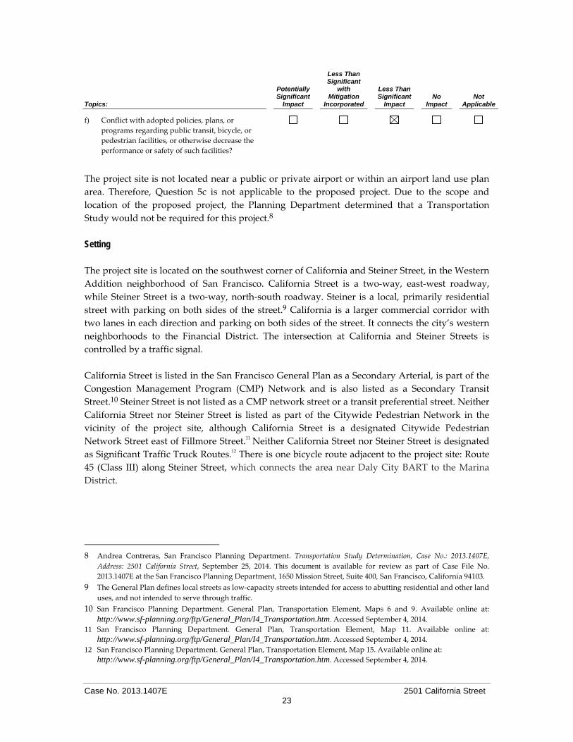
f) Conflict with adopted policies, plans, or
programs regarding public transit, bicycle, or
pedestrian facilities, or otherwise decrease the
performance or safety of such facilities?
The project site is not located near a public or private airport or within an airport land use plan
area. Therefore, Question 5c is not applicable to the proposed project. Due to the scope and
location of the proposed project, the Planning Department determined that a Transportation
Study would not be required for this project.8
Setting
The project site is located on the southwest corner of California and Steiner Street, in the Western
Addition neighborhood of San Francisco. California Street is a two‐way, east‐west roadway,
while Steiner Street is a two‐way, north‐south roadway. Steiner is a local, primarily residential
street with parking on both sides of the street.9 California is a larger commercial corridor with
two lanes in each direction and parking on both sides of the street. It connects the city’s western
neighborhoods to the Financial District. The intersection at California and Steiner Streets is
controlled by a traffic signal.
California Street is listed in the San Francisco General Plan as a Secondary Arterial, is part of the
Congestion Management Program (CMP) Network and is also listed as a Secondary Transit
Street.10 Steiner Street is not listed as a CMP network street or a transit preferential street. Neither
California Street nor Steiner Street is listed as part of the Citywide Pedestrian Network in the
vicinity of the project site, although California Street is a designated Citywide Pedestrian
Network Street east of Fillmore Street.11 Neither California Street nor Steiner Street is designated
as Significant Traffic Truck Routes.12 There is one bicycle route adjacent to the project site: Route
45 (Class III) along Steiner Street, which connects the area near Daly City BART to the Marina
District.
8 Andrea Contreras, San Francisco Planning Department. Transportation Study Determination, Case No.: 2013.1407E,
Address: 2501 California Street, September 25, 2014. This document is available for review as part of Case File No.
2013.1407E at the San Francisco Planning Department, 1650 Mission Street, Suite 400, San Francisco, California 94103.
9 The General Plan defines local streets as low‐capacity streets intended for access to abutting residential and other land
uses, and not intended to serve through traffic. 10 San Francisco Planning Department. General Plan, Transportation Element, Maps 6 and 9. Available online at:
http://www.sf-planning.org/ftp/General_Plan/I4_Transportation.htm. Accessed September 4, 2014.
11 San Francisco Planning Department. General Plan, Transportation Element, Map 11. Available online at:
http://www.sf-planning.org/ftp/General_Plan/I4_Transportation.htm. Accessed September 4, 2014.
12 San Francisco Planning Department. General Plan, Transportation Element, Map 15. Available online at:
http://www.sf-planning.org/ftp/General_Plan/I4_Transportation.htm. Accessed September 4, 2014.

Case No. 2013.1407E 2501 California Street 24
There is one existing driveway along the project site frontage on California Street (approximately
31 feet in width) and there are two existing driveways along the project site frontage on Steiner
Street (both approximately 33 feet in width).
The project site is served by the San Francisco Municipal Railway (Muni), which provides access
to other local and regional public transit providers, such as Bay Area Rapid Transit (BART) (Civic
Center BART Station is the closest one to the project site), and San Mateo County Transit District
(SamTrans). Muni bus routes within a two block radius of the project site include: 1‐California
and 1 BX‐California B Express, which run along California Street; and 3‐Jackson and 22‐Fillmore,
which run along Fillmore Street. The nearest Muni bus stop to the project site is at the
intersection of Fillmore and Steiner Streets, and is served by the 1‐California bus line. Other bus
stops within a quarter‐mile radius of the project site are located along California, Steiner, and
Fillmore Streets.
There is a signalized pedestrian crosswalk at the project intersection, and three of the four
intersections that surround the project block also contain signalized crosswalks. The intersection
of California and Pierce Street is controlled via a stop sign.
Impact TR‐1: The proposed project would not conflict with an applicable plan, ordinance, or
policy establishing measures of effectiveness for the performance of the circulation system,
taking into account all modes of transportation, nor would the proposed project conflict with
an applicable congestion management program including, but not limited to, level of service
standards and travel demand measures. (Less than Significant)
Policy 10.4 of the Transportation Element of the San Francisco General Plan states that the City
will “Consider the transportation system performance measurements in all decisions for projects
that affect the transportation system.” To determine whether the proposed project would conflict
with a transportation‐ or circulation‐related plan, ordinance or policy, this section analyzes the
proposed project’s effects on intersection operations, transit demand, impacts on pedestrian and
bicycle circulation and freight loading, as well as construction impacts.
Trip Generation
As set forth in the Planning Department’s October 2002 Transportation Impact Analysis
Guidelines for Environmental Review (Guidelines), the Planning Department evaluates traffic
conditions for the weekday p.m. peak‐period to determine the significance of an adverse
environmental impact. These weekday p.m. peak hour conditions typically represent the worst
conditions of the local transportation network. The proposed project would merge the three lots
into one, remove all existing above‐ and below‐ground structures on the site, and construct a 19‐
foot‐tall, approximately 2,600‐sf fueling canopy with five fueling dispensers, two underground
storage tanks and associated underground pipes, and a structure containing an approximately
2,300‐sf convenience store on the ground level with approximately 2,300‐sf of storage space in a
below‐grade basement. The proposed project would remove eight existing off‐site, at‐grade
parking spaces and provide two new off‐site, at‐grade parking spaces.
Case No. 2013.1407E 2501 California Street 25
Trip generation rates for the proposed project were developed using the trips generation rate
provided through the Institute of Transportation Engineers (ITE) (Trip Generation Manual, 8th
Edition) for “Gasoline/Service Station with Convenience Market.”13 This rate is 13.38 p.m. peak
hour trips per fueling position. The proposed project would construct five fueling bays, each of
which would contain two fueling positions (or pumps), for a total of 10 fueling positions. Thus,
the proposed project would generate approximately 134 p.m. peak hour trips. As noted above,
the project site currently contains three fueling bays (with six fueling positions), which generate
approximately 80 p.m. peak hour trips. Thus, the project‐related net increase in p.m. peak hour
trips as compared to existing conditions would be 54. The majority, if not all, of the 54 net new
p.m. peak hour trips are assumed to be vehicle trips.
These 54 p.m. peak hour trips would not be considered a substantial traffic increase relative to
the existing capacity of the local street system. Residents and businesses along California and
Steiner Streets would experience an increase in vehicular activity as a result of the proposed
project; however, since a similar level and type of activity already occurs on the project site, this
increase in trips would not be substantial enough to result in significant impacts related to ability
of the local street system to accommodate additional vehicle trips. Overall, the net increase in the
trip generation rate for the proposed project would be less‐than‐significant relative to the existing
capacity of the local street system.
Loading The project would not provide any off‐street loading spaces and none is required by the Planning
Code. Section 152 (Schedule of Required Off‐Street Freight Loading Spaces) does not require off‐
street loading for retail stores smaller than 10,000 sf in size (the proposed convenience store
would be 2,300 sf in size) and does not require loading spaces for fueling stations. The fuel
delivery for the station would be via a tanker truck and would occur five time times per week,
while truck deliveries to the convenience store would occur once a week (the fueling truck would
enter the site via the California Street driveway and exit via the Steiner Street driveway). These
deliveries, which already occur at the project site under existing conditions, would continue to
occur and would not be expected to block or otherwise impact the adjacent roadways. Therefore,
the project would not result in significant loading impacts and loading impacts are considered
less than significant.
Construction Activities During the projected six‐month construction period, temporary and intermittent traffic and
transit impacts would result from truck movements to and from the project site. Truck
movements during periods of peak traffic flow would have greater potential to create conflicts
than during non‐peak hours because of the greater numbers of vehicles on the streets during the
peak hour that would have to maneuver around queued trucks. Construction activities associated
with the proposed project are not anticipated to result in substantial impacts on the City’s
13 The Planning Department’s Guidelines do not cover all possible uses to determine project trip generation. In those
cases, it is appropriate to use other data sources or studies for trip generation rates, including acceptable published
data from the Institute of Transportation Engineers (ITE). In its Trip Generation publication, the Institute of
Transportation Engineers (ITE) provides one of the largest sources of commonly used trip generation data.
Case No. 2013.1407E 2501 California Street 26
transportation network. However, as required, the project sponsor and construction contractors
would meet with the City’s Transportation Advisory Staff Committee (TASC) to determine
feasible measures to reduce traffic congestion, including effects on the transit system and
pedestrian circulation impacts during construction of the proposed project. TASC consists of
representatives from the Traffic Engineering Division of San Francisco Municipal Transportation
Agency (SFMTA), the Fire Department, and the Planning Department. Thus, impacts related to
an applicable transportation circulation system plan or policy would be less than significant.
Impact TR‐2: The proposed project would not result in substantially increased hazards due to
a design feature (e.g., sharp curves or dangerous intersections) or incompatible uses. (Less than
Significant)
The proposed project would not include any design features that would substantially increase
traffic hazards (e.g., a new sharp curve or dangerous intersections), and would not include any
incompatible uses, as discussed above in Topic 1, Land Use and Land Use Planning. Therefore,
the project would not have adverse impacts associated with traffic hazards.
As discussed above, as part of the proposed project, the northern driveway on Steiner Street
would be eliminated and the two remaining driveways (one on California Street and one on
Steiner Street) would be reduced to 28 feet in width. The proposed driveways would function
largely the same as under the existing conditions. Per Planning Code Sections 102.32, 142 and
156, visual screening is required along the perimeter of the vehicular use areas (the project site).
The height of the proposed screening, at 3 feet tall, would allow for exiting vehicles to maintain
visual access toward the on‐coming vehicles and bicycles on Steiner Street.
As noted above, the project site is adjacent to bicycle Route 45 (Class III) along Steiner Street,
which connects the area near Daly City BART to the Marina District. Because the project would
eliminate the northern driveway on Steiner Street and reduce the width of the two remaining
driveways (one on California Street and one of Steiner Street), it could improve conditions for
bicycles by reducing the potential for conflicts between bicycles and vehicles entering and
existing the site. Moreover, as noted above, the proposed screening along the site’s perimeter, at 3
feet in height, is unlikely to increase the potential for such conflicts. Thus, compared to the
existing conditions, the project would not be expected to result in significant impacts with respect
to hazards.
Impact TR‐3: The proposed project would not result in inadequate emergency access. (Less
than Significant)
The proposed project would not result in a significant impact with regard to emergency access
and would not interfere with existing traffic circulation or cause major traffic hazards. The
proposed convenience store/storage space would be required to comply with the standards
contained in the Building and Fire Codes, and the Department of Building Inspection (DBI) and
Fire Department would review the final building plans to ensure sufficient access and safety. The
proposed project would therefore have a less‐than‐significant impact on emergency access
conditions on and near the project site.

Case No. 2013.1407E 2501 California Street 27
Impact TR‐4: The proposed project would not conflict with adopted policies, plans or
programs regarding public transit, bicycle or pedestrian facilities, or otherwise decrease the
performance or safety of such features. (Less than Significant)
Transit Conditions As discussed above, the project site is well served by transit. It is anticipated that the majority of
trips to and from the proposed project during the p.m. peak hour would be made by
automobiles, pedestrians, and/or bicyclists, and therefore the number of transit trips generated by
the proposed project would be minimal. Given the proposed uses, it is unlikely that individuals
would utilize public transit specifically to patronize the proposed convenience store (or,
especially, the fueling station). Rather, it is expected that most individuals would access the site
via an automobile or as a pedestrian or bicyclist on their way to another destination. Based on
this, any peak hour transit trips that would be generated by the proposed project would be
accommodated by the existing transit system. The addition of the project‐generated transit riders
would not substantially increase the peak hour capacity utilization of the MUNI bus lines
considered for the proposed project. As part of this project, the northern driveway on Steiner
Street would be eliminated and the two remaining driveways (one on California Street and one
on Steiner Street) would be reduced to 28 feet in width. The project would not be expected to
result in any conflicts with the bus operations on California Street; therefore, no impacts to bus
circulation were identified (no bus lines operate along Steiner Street on the project block).
Bicycle Conditions As mentioned above, there is a bicycle route near the project site ‐ Route 45 (Class III) along
Steiner Street. The proposed project is not anticipated to adversely affect bicycle conditions in the
project vicinity. Although the proposed project would result in an increase in the number of
vehicles in the vicinity of the project site (approximately 50 net new trips during the p.m. peak
hour), this increase would not be substantial enough to affect bicycle travel in the area. As
discussed above, under Impact TR‐2, the proposed project would eliminate the northern
driveway on Steiner Street and reduce the width of the two remaining driveways (one on
California Street and one of Steiner Street), which could improve conditions for bicycles by
reducing the potential for conflicts between bicycles and vehicles entering and existing the site.
Moreover, any required screening along the site’s perimeter would be designed to avoid such
potential conflicts. Therefore, the proposed project would have a less‐than‐significant impact on
the bicycle conditions in the project vicinity.
On June 26, 2009, the San Francisco Municipal Transportation Agency (SFMTA) approved an
update to the City’s Bicycle Plan. The Plan includes updated goals and objectives to encourage
bicycle use in the City, describes the existing bicycle route network (a series of interconnected
streets and pathways on which bicycling is encouraged) and identifies improvements to achieve
the established goals and objectives. The proposed project would not result in significant impacts
to bicycle conditions in the project area and would therefore not conflict with the City’s bicycle
plan, or other plan, policy or program related to bicycle use in San Francisco.

Case No. 2013.1407E 2501 California Street 28
Pedestrian Conditions Given the proposed uses, the project would generate a negligible number of pedestrian trips to
the surrounding streets during the weekday p.m. peak hour. These new pedestrian trips would
be spread out over several adjacent sidewalks and crosswalks and could be accommodated on
the existing facilities adjacent to the project site without substantially affecting the current
pedestrian conditions along California Street (10‐foot‐wide sidewalks) or Steiner Street (15‐foot‐
wide sidewalks). Therefore, it is expected that pedestrian conditions would continue to remain
acceptable.
The project would not result in a considerable increase in vehicle trips to and from the site, and
therefore pedestrian travel in the project site vicinity would not be substantially affected. In
addition, the proposed project would not create unsafe conditions for pedestrians, nor would the
additional walk trips cause crowding on nearby sidewalks; therefore, the proposed project’s
impact to pedestrian facilities would be less than significant. Sidewalk widths are sufficient to
allow for the free flow of pedestrian traffic. Pedestrian activity would increase as a result of the
project, but not to a degree that could not be accommodated on local sidewalks or would result in
safety concerns. Thus, impacts on pedestrian circulation and safety would be less than significant.
As such, the proposed project would not conflict with any plan, policy or program related to
pedestrian use in San Francisco.
Impact C‐TR‐1: The proposed project in combination of past, present, and reasonably
foreseeable future projects, would not result in substantial cumulative transportation impacts.
(Less than Significant)
Construction of the proposed project may overlap with construction of other projects within a
quarter mile of the project site, which could result in a temporary increase in construction‐related
traffic in the project vicinity. As noted above, these construction activities include such activities
as seismic retrofits and ADA improvements at 2390 Bush Street, replacement of an existing
driveway and reroofing at 2210 Pine Street, and emergency reinforcement work to stabilize the
existing front facade at 2178 Pine Street. The combined construction impacts would not be
significant given that they are temporary and would not result in permanent, cumulatively
considerable transportation impacts. The operation of the proposed project would not result in a
significant increase in trips to and from the project site as discussed above. Therefore, the project
would not contribute significantly to cumulative conditions and would not have any significant
cumulative traffic impacts.
For the reasons discussed above, the proposed project’s impacts related to transportation, both
individually and cumulatively, would be less than significant.
Parking Discussion Impact TR‐5: Implementation of the proposed project would not result in a significant parking
impact. (Less than Significant)
Parking impacts are not considered significant under CEQA, but a discussion of parking is
presented here as an information item.

Case No. 2013.1407E 2501 California Street 29
Based on the methodology presented in the Planning Department’s 2002 Transportation Impact
Analysis Guidelines, on an average weekday, the proposed retail uses would have a short‐term
parking demand of four spaces and a long‐term parking demand of two spaces. The project
would provide a total of five on‐site parking spaces. Therefore, the parking proposed to be
provided would be slightly less than the parking demand generated by the proposed project.
There is limited on‐street parking capacity available near the project site along both California
and Steiner Streets. While the proposed off‐street parking spaces would be slightly less than the
anticipated demand, the resulting parking deficit is considered to be a less‐than‐significant
impact, regardless of the availability of on‐street parking under existing conditions.
San Francisco does not consider parking supply as part of the permanent physical environment.
Parking conditions are not static, as parking supply and demand varies from day to day, from
day to night, from month to month, etc. Hence, the availability of parking spaces (or lack thereof)
is not a permanent physical condition, but changes over time as people change their modes and
patterns of travel.
Parking deficits are considered to be social effects, rather than impacts on the physical
environment as defined by CEQA. Under CEQA, a project’s social impacts need not be treated as
significant impacts on the environment. Environmental documents should, however, address the
secondary physical impacts that could be triggered by a social impact (CEQA Guidelines
§15131(a)). The social inconvenience of parking deficits, such as having to hunt for scarce parking
spaces, is not an environmental impact, but there may be secondary physical environmental
impacts, such as increased traffic congestion at intersections, air quality impacts, safety impacts,
or noise impacts caused by congestion. In the experience of San Francisco transportation
planners, however, the absence of a ready supply of parking spaces, combined with available
alternatives to auto travel (e.g., transit service, taxis, bicycles or travel by foot) and a relatively
dense pattern of urban development, induces many drivers to seek and find alternative parking
facilities, shift to other modes of travel, or change their overall travel habits. Any such resulting
shifts to transit service in particular, would be in keeping with the City’s ʺTransit Firstʺ policy.
The City’s Transit First Policy, established in the City’s Charter Section 16.102 provides that
ʺparking policies for areas well served by public transit shall be designed to encourage travel by
public transportation and alternative transportation.ʺ As discussed above, the project area is well‐
served by local public transit (Muni’s bus routes 1, 1 BX, 3, and 22) as well as by bicycle Route 45
which provide alternatives to auto travel.
The transportation analysis accounts for potential secondary effects, such as cars circling and
looking for a parking space in areas of limited parking supply, by assuming that all drivers
would attempt to find parking at or near the project site and then seek parking farther away if
convenient parking is unavailable. Moreover, the secondary effects of drivers searching for
parking is typically offset by a reduction in vehicle trips due to others who are aware of
constrained parking conditions in a given area. Hence, any secondary environmental impacts
which may result from a shortfall in parking in the vicinity of the proposed project would be
minor, and the traffic assignments used in the transportation analysis, as well as in the associated

Case No. 2013.1407E 2501 California Street 30
air quality, noise and pedestrian safety analyses, reasonably addresses potential secondary
effects.
Topics:
Potentially Significant
Impact
Less Than Significant
with Mitigation
Incorporated
Less Than Significant
Impact No
Impact Not
Applicable
6. NOISE—Would the project:
a) Result in exposure of persons to or generation of
noise levels in excess of standards established in
the local general plan or noise ordinance, or
applicable standards of other agencies?
b) Result in exposure of persons to or generation of
excessive groundborne vibration or groundborne
noise levels?
c) Result in a substantial permanent increase in
ambient noise levels in the project vicinity above
levels existing without the project?
d) Result in a substantial temporary or periodic
increase in ambient noise levels in the project
vicinity above levels existing without the
project?
e) For a project located within an airport land use
plan area, or, where such a plan has not been
adopted, in an area within two miles of a public
airport or public use airport, would the project
expose people residing or working in the area to
excessive noise levels?
f) For a project located in the vicinity of a private
airstrip, would the project expose people
residing or working in the project area to
excessive noise levels?
g) Be substantially affected by existing noise levels?
The project site is not located within an airport land use plan area, or within the vicinity of a
private airstrip. Therefore, Questions 6e and 6f are not applicable to the proposed project.
Impact NO‐1: The proposed project would not result in the exposure of persons to or
generation of noise levels in excess of established standards, nor would the proposed project
result in a substantial permanent increase in ambient noise levels or otherwise be
substantially affected by existing noise. (Less than Significant)
The proposed project would not include new sensitive receptors, including residences, schools,
hospitals, and convalescent homes, where people require quiet for sleep or concentration. The
nearest sensitive receptors to the project site are the residences along Steiner and California

Case No. 2013.1407E 2501 California Street 31
Streets (including residential uses on parcels on parcels adjacent to the project site along both of
these streets).
Applicable Noise Standards. The Environmental Protection Element of the San Francisco
General Plan contains Land Use Compatibility Guidelines for Community Noise. These
guidelines, which are similar to state guidelines promulgated by the Governor’s Office of
Planning and Research (OPR), indicate maximum acceptable noise levels for various newly
developed land uses. The proposed uses for this project most closely correspond to the
“Commercial – Wholesale and Some Retail, Industrial/Manufacturing, Transportation,
Communications and Utilities” land use category in the Land Use Compatibility Guidelines.14 For
this land use category, the maximum “satisfactory, with no special insulation requirements”
exterior noise levels are approximately 77 dBA (Ldn).15,16 Where exterior noise levels exceed 75
dBA (Ldn) for a new commercial building, it is generally recommended that a detailed analysis of
noise reduction requirements be conducted prior to final review and approval of the project, and
that the needed noise insulation features be include in the project design.
Existing Noise in Project Site Vicinity. The land uses in the project site vicinity generate a
substantial amount of noise. Based on citywide modeling of traffic noise volumes conducted by
the San Francisco Department of Public Health (DPH), the project site vicinity has ambient noise
levels ranging from 70 to 75 dBA (Ldn) on Steiner Street and ambient noise levels above 75 dBA
(Ldn) on California Street.
Project Noise Exposure. As previously mentioned, the proposed project would not include new
sensitive receptors. The exterior noise levels along Steiner Streets are within the range considered
“satisfactory” for transportation‐related buildings and commercial uses. While the exterior noise
levels along California Street exceed the maximum “satisfactory” noise levels for commercial
buildings, the proposed convenience store would be set back from California Street by
approximately 100 feet. Noise levels from a particular source generally decline as distance to the
receptor increases. Therefore, the project would not be expected to result in a significant impact
with respect to exposure of employees or visitors at the project site to ambient noise levels.
Moreover, as noted above, the project would replace uses that already exist on the project site;
therefore, any changes related to project noise exposure would be very minor when compared to
the existing conditions.
Noise from Project Operations. The proposed project includes removal of all existing above‐ and
below‐ground structures on the site and construction of a fueling canopy with five fuel
14 San Francisco General Plan. Environmental Protection Element, Land Use Compatibility Chart for Community Noise.
Available online at: http://www.sf‐planning.org/ftp/General_Plan/I6_Environmental_Protection.htm. Accessed
October 1, 2014.
15 The dBA, or A‐weighted decibel, refers to a scale of noise measurement that approximates the range of sensitivity of
the human ear to sounds of different frequencies. On this scale, the normal range of human hearing extends from
about 0 dBA to about 140 dBA. A 10‐dBA increase in the level of a continuous noise represents a perceived doubling
of loudness.
16 The Ldn is the Leq, or Energy Equivalent Level, of the A‐weighted noise level over a 24‐hour period with a 10 dB
penalty applied to noise levels between 10:00 p.m. to 7:00 a.m. Leq is the level of a steady noise which would have the
same energy as the fluctuating noise level integrated over the time period of interest.
Case No. 2013.1407E 2501 California Street 32
dispensers, two underground storage tanks and associated underground pipes, and a structure
containing an approximately 2,300‐sf convenience store on the ground level with approximately
2,300‐sf of storage space in a below‐grade basement.
Vehicular traffic makes the greatest contribution to ambient noise levels throughout most of San
Francisco. Generally, traffic must double in volume to produce a noticeable increase in the
ambient noise level in the project vicinity. The proposed project would generate approximately
1,489 daily vehicle trips, with 134 of those trips occurring in the p.m. peak hour. This would
constitute an increase of approximately 600 daily vehicle trips and 54 p.m. peak hour trips as
compared to the existing operations on the project site. This increase in vehicle trips would not
cause traffic volumes to double on nearby streets, and it would not have a noticeable effect on
ambient noise levels in the project site vicinity. The project also would not contribute to any
potential cumulative traffic noise effects. As a relatively small fueling station/convenience store
development, the proposed project would not include features or uses that could generate
substantial noise, particularly since the proposed project would expand a use that already exists
on the project site. Automobiles and pedestrians would access the proposed uses throughout the
day and night in a manner similar to the existing conditions and would not be expected to
generate a noticeable level of noise. Similarly, deliveries of fuel and convenience store goods
would be made to the project site the same as deliveries made under the existing conditions.
Therefore, operational noise from the proposed project, including traffic‐related noise, would not
be expected to significantly increase the ambient noise levels in the project vicinity.
In addition to vehicle‐related noise, building equipment and ventilation associated with the
proposed convenience store would also constitute new sources of noise. Mechanical equipment
would be subject to Section 2909 of the Noise Ordinance. This section of the ordinance establishes
a noise limit from mechanical sources, such as building equipment, specified as a certain noise
level in excess of the ambient noise level at the property line: for noise generated by residential
uses, the limit is 5 dBA in excess of ambient, while for noise generated by commercial and
industrial uses, the limit is 8 dBA in excess of ambient and for noise on public property, including
streets, the limit is 10 dBA in excess of ambient. Compliance with Article 29, Section 2909, serves
to minimize noise from building operations. Therefore, noise effects related to building operation
would be less than significant. Given that the proposed project’s vehicle trips would not result in
a noticeable increase in ambient noise levels, and that any proposed mechanical equipment
would be required to comply with the Noise Ordinance, the proposed project would not result in
a noticeable increase in ambient noise levels. Thus, the project’s impact related to project
operations would be less than significant.
Impact NO‐2: During construction, the proposed project would not result in a substantial
temporary or periodic increase in ambient noise levels and vibration in the project vicinity
above levels existing without the project. (Less than Significant)
Demolition, excavation and building construction would temporarily increase noise, and possibly
vibration, in the project vicinity. During the construction phase, the amount of construction noise
generated would be influenced by equipment type and duration of use, distance between noise
source and listener, and presence or absence of barriers (including subsurface barriers).

Case No. 2013.1407E 2501 California Street 33
Construction equipment would generate noise and possibly vibrations that could be considered
an annoyance by occupants of nearby properties. There would be times when noise and vibration
could interfere with indoor activities in nearby businesses.
The nearest sensitive receptors to the project site are the residential uses along Steiner and
California Street, adjacent to the project site (less than 10 feet away). Given that these uses are
currently subject to the ambient noise levels that are considered to be relatively high (particularly
along California Street, where noise levels are above 75 dBA (Ldn)) and moreover, are subject to
uses that would be essentially the same as under the proposed project, the operational noise from
the proposed project would not significantly impact these residential uses. There are no senior
center or hospital facilities near the project site. Other uses in the immediate vicinity are not
considered sensitive to noise and vibration.
According to the project sponsor, the construction period would last approximately six months.
Preliminary design recommendations indicate that the proposed convenience store building can
be supported on conventional spread/strip footings.17 The partial basement area below the
convenience store may be supported on a concrete mat foundation and the fueling canopy may
be supported on drilled, cast-in-place, reinforced concrete piers. No significant noise generating
equipment (including pile driving) would be used during the construction phase of the project.
The primary noise source during the construction phase of this project would be concrete mixer
trucks and similar equipment. The proposed project would not create unusual levels of
groundborne vibration that would disturb nearby businesses and occupants.
Excavation work and exterior finishing can generate noise levels up to 89 dBA (Ldn) at 50 feet
from the noise receptor (see
Table 1, on the following page). Construction noise and vibration impacts would be temporary
in nature and limited to the period of construction. Noise generally attenuates (decreases) at a
rate of 6 to 7.5 dBA per doubling of distance, and would therefore not be anticipated to
substantially affect the nearby noise sensitive receptors located further along California and
Steiner Streets from the project site.
17 BAGG Engineers, Geotechnical Engineering Investigation, Proposed Shell Gas Station & Loop Convenience Store, 2501
California Street, San Francisco, California, October 2013 (hereinafter “Preliminary Geotechnical Evaluation”). A copy of
this document is available for review at the San Francisco Planning Department, 1650 Mission Street, Suite 400 as part
of Case File 2013.1407E.
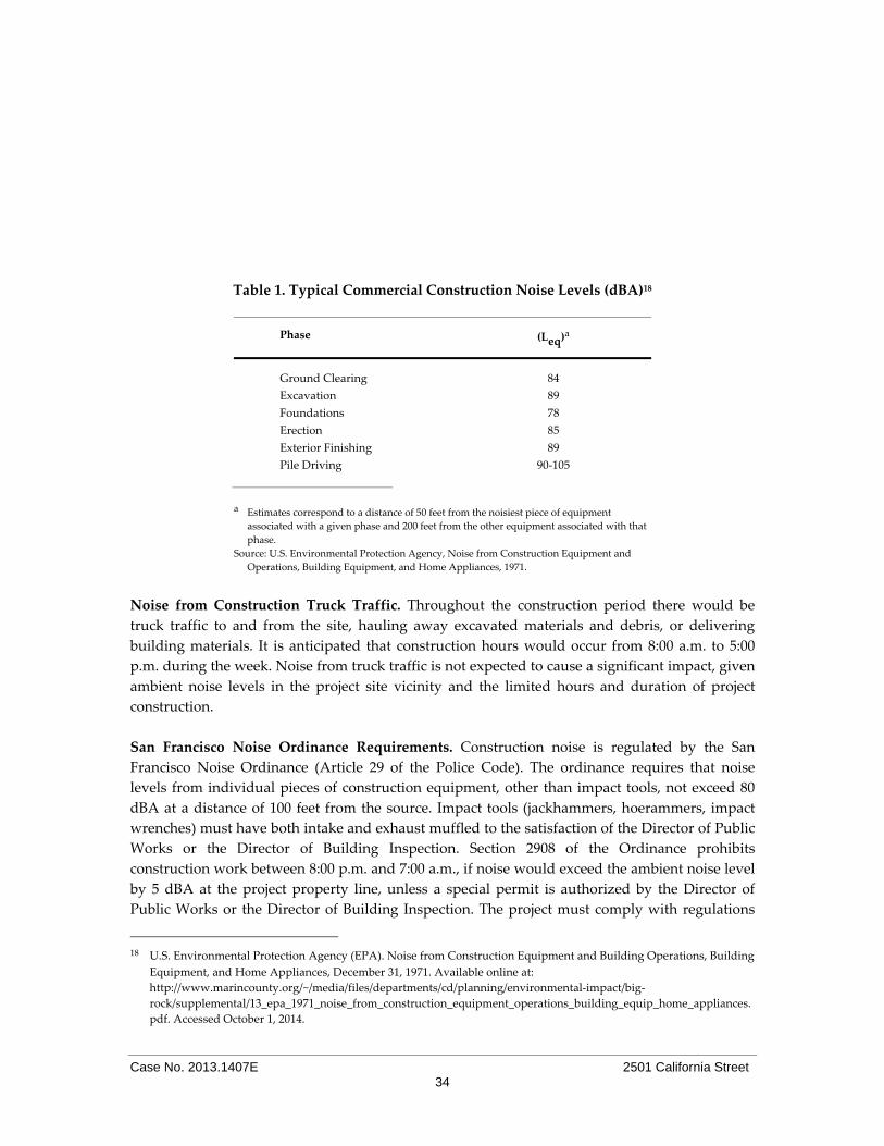
Case No. 2013.1407E 2501 California Street 34
Table 1. Typical Commercial Construction Noise Levels (dBA)18
Phase (Leq)a
Ground Clearing 84
Excavation 89
Foundations 78
Erection 85
Exterior Finishing 89
Pile Driving 90‐105
a Estimates correspond to a distance of 50 feet from the noisiest piece of equipment
associated with a given phase and 200 feet from the other equipment associated with that
phase.
Source: U.S. Environmental Protection Agency, Noise from Construction Equipment and
Operations, Building Equipment, and Home Appliances, 1971.
Noise from Construction Truck Traffic. Throughout the construction period there would be
truck traffic to and from the site, hauling away excavated materials and debris, or delivering
building materials. It is anticipated that construction hours would occur from 8:00 a.m. to 5:00
p.m. during the week. Noise from truck traffic is not expected to cause a significant impact, given
ambient noise levels in the project site vicinity and the limited hours and duration of project
construction.
San Francisco Noise Ordinance Requirements. Construction noise is regulated by the San
Francisco Noise Ordinance (Article 29 of the Police Code). The ordinance requires that noise
levels from individual pieces of construction equipment, other than impact tools, not exceed 80
dBA at a distance of 100 feet from the source. Impact tools (jackhammers, hoerammers, impact
wrenches) must have both intake and exhaust muffled to the satisfaction of the Director of Public
Works or the Director of Building Inspection. Section 2908 of the Ordinance prohibits
construction work between 8:00 p.m. and 7:00 a.m., if noise would exceed the ambient noise level
by 5 dBA at the project property line, unless a special permit is authorized by the Director of
Public Works or the Director of Building Inspection. The project must comply with regulations
18 U.S. Environmental Protection Agency (EPA). Noise from Construction Equipment and Building Operations, Building
Equipment, and Home Appliances, December 31, 1971. Available online at:
http://www.marincounty.org/~/media/files/departments/cd/planning/environmental‐impact/big‐
rock/supplemental/13_epa_1971_noise_from_construction_equipment_operations_building_equip_home_appliances.
pdf. Accessed October 1, 2014.
Case No. 2013.1407E 2501 California Street 35
set forth in the Noise Ordinance. The increase in noise and vibration in the project area during
project construction would be considered less than significant because it would be temporary,
intermittent, and restricted in occurrence and level, as the contractor would be required to
comply with the City’s Noise Ordinance.
In light of the above, the project’s construction noise impact would be less than significant.
Impact C‐NO‐1: The proposed project would not make a considerable contribution to any
cumulative significant noise impacts. (Less than Significant)
Construction activities in the vicinity of the project site, such as any required excavation, grading,
or construction of other buildings in the area, would occur on a temporary and intermittent basis,
similar to the project. Project construction‐related noise would not substantially increase ambient
noise levels at locations greater than a few hundred feet from the project site. As such,
construction noise effects associated with the proposed project are not anticipated to combine
with those associated with other proposed and ongoing projects located near the project site.
Therefore, cumulative construction‐related noise impacts would be less than significant.
Localized traffic noise would increase in conjunction with foreseeable residential and commercial
growth in the project vicinity. However, because neither the proposed project nor the other
cumulative projects in the vicinity are anticipated to result in a doubling of traffic volumes along
nearby streets, the project would not contribute considerably to any cumulative traffic‐related
increases in ambient noise. Moreover, the proposed project’s mechanical equipment would be
required to comply with the Noise Ordinance and would not be expected to contribute to any
cumulative increases in ambient noise levels. Therefore, the proposed project would not result in
cumulatively considerable noise impacts, and cumulative noise impacts would be less than
significant.
Topics:
Potentially Significant
Impact
Less Than Significant
with Mitigation
Incorporated
Less Than Significant
Impact No
Impact Not
Applicable
7. AIR QUALITY
Where available, the significance criteria established by the applicable air quality management or air pollution control
district may be relied upon to make the following determinations. Would the project:
a) Conflict with or obstruct implementation of the
applicable air quality plan?
b) Violate any air quality standard or contribute
substantially to an existing or projected air
quality violation?

Case No. 2013.1407E 2501 California Street 36
Topics:
Potentially Significant
Impact
Less Than Significant
with Mitigation
Incorporated
Less Than Significant
Impact No
Impact Not
Applicable
c) Result in a cumulatively considerable net
increase of any criteria pollutant for which the
project region is non‐attainment under an
applicable federal, state, or regional ambient air
quality standard (including releasing emissions
which exceed quantitative thresholds for ozone
precursors)?
d) Expose sensitive receptors to substantial
pollutant concentrations?
e) Create objectionable odors affecting a substantial
number of people?
Setting The Bay Area Air Quality Management District (BAAQMD) is the regional agency with
jurisdiction over the nine‐county San Francisco Bay Area Air Basin (SFBAAB), which includes
San Francisco, Alameda, Contra Costa, Marin, San Mateo, Santa Clara, and Napa Counties and
portions of Sonoma and Solano Counties. The BAAQMD is responsible for attaining and
maintaining air quality in the SFBAAB within federal and state air quality standards, as
established by the federal Clean Air Act (CAA) and the California Clean Air Act (CCAA),
respectively. Specifically, the BAAQMD has the responsibility to monitor ambient air pollutant
levels throughout the SFBAAB and to develop and implement strategies to attain the applicable
federal and state standards. The CAA and the CCAA require plans to be developed for areas that
do not meet air quality standards, generally. The most recent air quality plan, the 2010 Clean Air
Plan (CAP), was adopted by the BAAQMD on September 15, 2010. The 2010 CAP updates the Bay
Area 2005 Ozone Strategy in accordance with the requirements of the CCAA to implement all
feasible measures to reduce ozone; provide a control strategy to reduce ozone, particulate matter,
air toxics, and greenhouse gases in a single, integrated plan; and establish emission control
measures to be adopted or implemented. The 2010 CAP contains the following primary goals:
Attain air quality standards;
Reduce population exposure and protect public health in the San Francisco Bay Area;
and
Reduce greenhouse gas emissions and protect the climate.
The 2010 CAP represents the most current applicable air quality plan for the SFBAAB.
Consistency with this plan is the basis for determining whether the proposed project would
conflict with or obstruct implementation of an applicable air quality plan.
Criteria Air Pollutants In accordance with the state and federal CAAs, air pollutant standards are identified for the
following six criteria air pollutants: ozone, carbon monoxide (CO), particulate matter (PM),
nitrogen dioxide (NO2), sulfur dioxide (SO2), and lead. These air pollutants are termed criteria air
pollutants because they are regulated by developing specific public health‐ and welfare‐based

Case No. 2013.1407E 2501 California Street 37
criteria as the basis for setting permissible levels. In general, the SFBAAB experiences low
concentrations of most pollutants when compared to federal or state standards. The SFBAAB is
designated as either in attainment19 or unclassified for most criteria pollutants with the exception
of ozone, PM2.5, and PM10, for which these pollutants are designated as non‐attainment for either
the state or federal standards. By its very nature, regional air pollution is largely a cumulative
impact in that no single project is sufficient in size to, by itself, result in non‐attainment of air
quality standards. Instead, a project’s individual emissions contribute to existing cumulative air
quality impacts. If a project’s contribution to cumulative air quality impacts is considerable, then
the project’s impact on air quality would be considered significant.20
Land use projects may contribute to regional criteria air pollutants during the construction and
operational phases of a project.
Table 2 on the following page identifies air quality significance thresholds followed by a
discussion of each threshold. Projects that would result in criteria air pollutant emissions below
these significance thresholds would not violate an air quality standard, contribute substantially to
an air quality violation, or result in a cumulatively considerable net increase in criteria air
pollutants within the SFBAAB.
Table 2. Criteria Air Pollutant Significance Thresholds
Pollutant
Construction Thresholds Operational Thresholds
Average Daily Emissions
(lbs./day)
Average Daily
Emissions
(lbs./day)
Maximum Annual
Emissions (tons/year)
ROG 54 54 10
NOx 54 54 10
PM10 82 (exhaust) 82 15
PM2.5 54 (exhaust) 54 10
Fugitive
Dust
Construction Dust Ordinance or
other Best Management Practices
Not Applicable
Ozone Precursors. As discussed previously, the SFBAAB is currently designated as non‐
attainment for ozone and particulate matter (PM10 and PM2.521). Ozone is a secondary air pollutant
produced in the atmosphere through a complex series of photochemical reactions involving
reactive organic gases (ROG) and oxides of nitrogen (NOx). The potential for a project to result in
a cumulatively considerable net increase in criteria air pollutants, which may contribute to an
existing or projected air quality violation, are based on the state and federal Clean Air Acts
emissions limits for stationary sources. The federal New Source Review (NSR) program was
created by the federal CAA to ensure that stationary sources of air pollution are constructed in a
19 “Attainment” status refers to those regions that are meeting federal and/or state standards for a specified criteria
pollutant. “Non‐attainment” refers to regions that do not meet federal and/or state standards for a specified criteria
pollutant. “Unclassified” refers to regions where there is not enough data to determine the region’s attainment status.
20 Bay Area Air Quality Management District (BAAQMD), California Environmental Quality Act Air Quality Guidelines,
May 2011, page 2‐1.
21 PM10 is often termed “coarse” particulate matter and is made of particulates that are 10 microns in diameter or larger.
PM2.5, termed “fine” particulate matter, is composed of particles that are 2.5 microns or less in diameter.

Case No. 2013.1407E 2501 California Street 38
manner that is consistent with attainment of federal health based ambient air quality standards.
Similarly, to ensure that new stationary sources do not cause or contribute to a violation of an air
quality standard, BAAQMD Regulation 2, Rule 2 requires that any new source that emits criteria
air pollutants above a specified emissions limit must offset those emissions. For ozone precursors
ROG and NOx, the offset emissions level is an annual average of 10 tons per year (or 54 pounds
(lbs.) per day).22 These levels represent emissions below which new sources are not anticipated to
contribute to an air quality violation or result in a considerable net increase in criteria air
pollutants.
Although this regulation applies to new or modified stationary sources, land use development
projects result in ROG and NOx emissions as a result of increases in vehicle trips, architectural
coating and construction activities. Therefore, the above thresholds can be applied to the
construction and operational phases of land use projects and those projects that result in
emissions below these thresholds, would not be considered to contribute to an existing or
projected air quality violation or result in a considerable net increase in ROG and NOx emissions.
Due to the temporary nature of construction activities, only the average daily thresholds are
applicable to construction phase emissions.
Particulate Matter (PM10 and PM2.5). The BAAQMD has not established an offset limit for PM2.5.
However, the emissions limit in the federal NSR for stationary sources in nonattainment areas is
an appropriate significance threshold. For PM10 and PM2.5, the emissions limit under NSR is 15
tons per year (82 lbs. per day) and 10 tons per year (54 lbs. per day), respectively. These emissions
limits represent levels below which a source is not expected to have an impact on air quality.23
Similar to ozone precursor thresholds identified above, land use development projects typically
result in particulate matter emissions as a result of increases in vehicle trips, space heating and
natural gas combustion, landscape maintenance, and construction activities. Therefore, the above
thresholds can be applied to the construction and operational phases of a land use project. Again,
because construction activities are temporary in nature, only the average daily thresholds are
applicable to construction‐phase emissions.
Fugitive Dust. Fugitive dust emissions are typically generated during construction phases.
Studies have shown that the application of best management practices (BMPs) at construction
sites significantly control fugitive dust;24 individual measures have been shown to reduce fugitive
dust by anywhere from 30 to 90 percent.25 The BAAQMD has identified a number of BMPs to
control fugitive dust emissions from construction activities.26 The City’s Construction Dust
Control Ordinance (Ordinance 176‐08, effective July 30, 2008) requires a number of measures to
22 BAAQMD, Revised Draft Options and Justification Report, California Environmental Quality Act Thresholds of Significance,
October 2009, page 17.
23 Revised Draft Options and Justification Report, California Environmental Quality Act Thresholds of Significance, October
2009, page 16.
24 Western Regional Air Partnership. 2006. WRAP Fugitive Dust Handbook. September 7, 2006. This document is available
online at http://www.wrapair.org/forums/dejf/fdh/content/FDHandbook_Rev_06.pdf. Accessed October 7, 2014. 25 BAAQMD, Revised Draft Options and Justification Report, California Environmental Quality Act Thresholds of
Significance, October 2009, page 27.
26 BAAQMD, CEQA Air Quality Guidelines, May 2011.

Case No. 2013.1407E 2501 California Street 39
control fugitive dust and the BMPs employed in compliance with the City’s Construction Dust
Control Ordinance is an effective strategy for controlling construction‐related fugitive dust.
Local Health Risks and Hazards In addition to criteria air pollutants, individual projects may emit toxic air contaminants (TACs).
TACs collectively refer to a diverse group of air pollutants that are capable of causing chronic
(i.e., of long‐duration) and acute (i.e., severe but of short‐term) adverse effects to human health,
including carcinogenic effects. Human health effects of TACs include birth defects, neurological
damage, cancer, and death. There are hundreds of different types of TACs with varying degrees
of toxicity. Individual TACs vary greatly in the health risk they present; at a given level of
exposure, one TAC may pose a hazard that is many times greater than another.
Unlike criteria air pollutants, TACs do not have ambient air quality standards but are regulated
by the BAAQMD using a risk‐based approach to determine which sources and pollutants to
control as well as the degree of control. A health risk assessment is an analysis in which human
health exposure to toxic substances is estimated, and considered together with information
regarding the toxic potency of the substances, to provide quantitative estimates of health risks.27
Air pollution does not affect every individual in the population in the same way, and some
groups are more sensitive to adverse health effects than others. Land uses such as residences,
schools, children’s day care centers, hospitals, and nursing and convalescent homes are
considered to be the most sensitive to poor air quality because the population groups associated
with these uses have increased susceptibility to respiratory distress or, as in the case of residential
receptors, their exposure time is greater than that for other land uses. Therefore, these groups are
referred to as sensitive receptors. Exposure assessment guidance typically assumes that
residences would be exposed to air pollution 24 hours per day, 350 days per year, for 70 years.
Therefore, assessments of air pollutant exposure to residents typically result in the greatest
adverse health outcomes of all population groups.
Exposures to fine particulate matter (PM2.5) are strongly associated with mortality, respiratory
diseases, and lung development in children, and other endpoints such as hospitalization for
cardiopulmonary disease.28 In addition to PM2.5, diesel particulate matter (DPM) is also of
concern. The California Air Resources Board (ARB) identified DPM as a TAC in 1998, primarily
based on evidence demonstrating cancer effects in humans.29 The estimated cancer risk from
exposure to diesel exhaust is much higher than the risk associated with any other TAC routinely
measured in the region.
27 In general, a health risk assessment is required if the BAAQMD concludes that projected emissions of a specific air
toxic compound from a proposed new or modified source suggest a potential public health risk. The applicant is then
subject to a health risk assessment for the source in question. Such an assessment generally evaluates chronic, long‐
term effects, estimating the increased risk of cancer as a result of exposure to one or more TACs.
28 SFDPH, Assessment and Mitigation of Air Pollutant Health Effects from Intra‐Urban Roadways: Guidance for Land Use
Planning and Environmental Review, May 2008.
29 California Air Resources Board (ARB), Fact Sheet, “The Toxic Air Contaminant Identification Process: Toxic Air
Contaminant Emissions from Diesel‐fueled Engines,” October 1998.

Case No. 2013.1407E 2501 California Street 40
In an effort to identify areas of San Francisco most adversely affected by sources of TACs, San
Francisco partnered with the BAAQMD to conduct a citywide health risk assessment based on on
an inventory and assessment of air pollution and exposures from mobile, stationary, and area
sources within San Francisco. Areas with poor air quality, termed “Air Pollutant Exposure Zone,”
were identified based on health‐protective criteria: that considers estimated cancer risk,
exposures to fine particulate matter, proximity to freeways, and location with particularly
vulnerable populations. Each of these criteria is discussed below.
Excess Cancer Risk. The above 100 per one million persons (100 excess cancer risk) criteria is
based on United State Environmental Protection Agency (USEPA) guidance for conducting air
toxic analyses and making risk management decisions at the facility and community‐scale level.30
As described by the BAAQMD, the USEPA considers a cancer risk of 100 per million to be within
the “acceptable” range of cancer risk. Furthermore, in the 1989 preamble to the National
Emissions Standards for Hazardous Air Pollutants (NESHAP) rulemaking,31 the USEPA states
that it “…strives to provide maximum feasible protection against risks to health from hazardous
air pollutants by (1) protecting the greatest number of persons possible to an individual lifetime
risk level no higher than approximately one in one million and (2) limiting to no higher than
approximately one in ten thousand [100 in one million] the estimated risk that a person living
near a plant would have if he or she were exposed to the maximum pollutant concentrations for
70 years.” The 100 per one million excess cancer cases is also consistent with the ambient cancer
risk in the most pristine portions of the Bay Area based on BAAQMD regional modeling.32
Fine Particulate Matter. In April 2011, the USEPA published Policy Assessment for the Particulate
Matter Review of the National Ambient Air Quality Standards, “Particulate Matter Policy
Assessment.” In this document, USEPA staff concludes that then federal annual PM2.5 standard of
15 μg/m3 should be revised to a level within the range of 13 to 11 μg/m3, with evidence strongly
supporting a standard within the range of 12 to 11 μg/m3. Air Pollutant Exposure Zone for San
Francisco is based on the health protective PM2.5 standard of 11 μg/m3, as supported by the
USEPA’s Particulate Matter Policy Assessment, although lowered to 10 μg/m3 to account for error
bounds in emissions modeling programs.
Proximity to Freeways. All lots within 500 feet of the freeways were also included in the APEZ
based on the CARB 2005 Land Use Handbook recommendations for siting sensitive land uses
near high volume roadways.33
Health Vulnerable Locations. Based on the BAAQMD’s evaluation of health vulnerability in the
Bay Area, those zip codes (94102, 94103, 94105, 94124, and 94130) in the worst quintile of Bay
Area Health vulnerability scores as a result of air pollution‐related causes were afforded
additional protection by lowering the standards for identifying lots in the Air Pollutant Exposure
30 BAAQMD, Revised Draft Options and Justification Report, California Environmental Quality Act Thresholds of Significance,
October 2009, page 67.
31 54 Federal Register 38044, September 14, 1989.
32 BAAQMD, Revised Draft Options and Justification Report, California Environmental Quality Act Thresholds of Significance,
October 2009, page 67. 33 California Environmental Protection Agency, California Air Resources Board, Air Quality and Land Use Handbook: A
Community Health Perspective, April 2005, p. 4, Table 1‐1. Available online at: http://www.arb.ca.gov/ch/landuse.htm.

Case No. 2013.1407E 2501 California Street 41
Zone to: (1) an excess cancer risk greater than 90 per one million persons exposed, and/or (2)
PM2.5 concentrations in excess of 9 μg/m3.34
The above citywide health risk modeling was also used as the basis in approving a series of
amendments to the San Francisco Building and Health Codes, generally referred to as the
Enhanced Ventilation Required for Urban Infill Sensitive Use Developments or Health Code,
Article 38 (Ordinance 224‐14, effective December 8, 2014) (Article 38). The purpose of Article 38 is
to protect the public health and welfare by establishing an Air Pollutant Exposure Zone and
imposing an enhanced ventilation requirement for all urban infill sensitive use development
within the Air Pollutant Exposure Zone. In addition, projects within the Air Pollutant Exposure
Zone require special consideration to determine whether the project’s activities would add
emissions to areas already adversely affected by poor air quality. The project site is located
within the Air Pollutant Exposure Zone.
Construction Air Quality Impacts
Project‐related air quality impacts fall into two categories: short‐term impacts from construction
and long‐term impacts from project operation. The following addresses construction‐related air
quality impacts resulting from the proposed project.
Impact AQ‐1: The proposed project’s construction activities would generate fugitive dust and
criteria air pollutants, but would not violate an air quality standard, contribute substantially to
an existing or projected air quality violation, or result in a cumulatively considerable net
increase in criteria air pollutants. (Less than Significant)
Construction activities (short‐term) typically result in emissions of ozone precursors and PM in
the form of dust (fugitive dust) and exhaust (e.g., vehicle tailpipe emissions). Emissions of ozone
precursors and PM are primarily a result of the combustion of fuel from on‐road and off‐road
vehicles. However, ROGs are also emitted from activities that involve painting, other types of
architectural coatings, or asphalt paving. The proposed project includes removal of all existing
above‐ and below‐ground structures on the site and construction of a fueling canopy with five
fueling dispensers, two underground storage tanks and associated underground pipes, and a
structure containing an approximately 2,300‐sf convenience store on the ground level with
approximately 2,300‐sf of storage space in a below‐grade basement. During the project’s
approximately 5 month construction period, construction activities would have the potential to
result in emissions of ozone precursors and PM, as discussed below.
Fugitive Dust
Project‐related demolition, excavation, grading, and other construction activities may cause
wind‐blown dust that could contribute particulate matter into the local atmosphere. Although
there are federal standards for air pollutants and implementation of state and regional air quality
control plans, air pollutants continue to have impacts on human health throughout the country.
California has found that particulate matter exposure can cause health effects at lower levels than
national standards. The current health burden of particulate matter demands that, where
34 Ordinance 224‐14 (Article 38), San Francisco Board of Supervisors File No. 140806.

Case No. 2013.1407E 2501 California Street 42
possible, public agencies take feasible available actions to reduce sources of particulate matter
exposure. According to the ARB, reducing particulate matter PM2.5 concentrations to state and
federal standards of 12 μg/m3 in the San Francisco Bay Area would prevent between 200 and
1,300 premature deaths.35
Dust can be an irritant causing watering eyes or irritation to the lungs, nose, and throat.
Demolition, excavation, grading, and other construction activities can cause wind‐blown dust
that adds particulate matter to the local atmosphere. Depending on exposure, adverse health
effects can occur due to this particulate matter in general and also due to specific contaminants
such as lead or asbestos that may be constituents of soil.
In response, the San Francisco Board of Supervisors approved a series of amendments to the San
Francisco Building and Health Codes generally referred hereto as the Construction Dust Control
Ordinance (Ordinance 176‐08, effective July 30, 2008) with the intent of reducing the quantity of
dust generated during site preparation, demolition and construction work in order to protect the
health of the general public and of onsite workers, minimize public nuisance complaints, and to
avoid orders to stop work by the Department of Building Inspection (DBI).
The Ordinance requires that all site preparation work, demolition, or other construction activities
within San Francisco that have the potential to create dust or to expose or disturb more than 10
cubic yards or 500 sf of soil comply with specified dust control measures whether or not the
activity requires a permit from DBI. The Director of DBI may waive this requirement for activities
on sites less than one half‐acre that are unlikely to result in any visible wind‐blown dust.
In compliance with the Construction Dust Control Ordinance, the project sponsor and the
contractor responsible for construction activities at the project site will be required to use the
following practices to control construction dust on the site or other practices that result in
equivalent dust control that are acceptable to the Director. Dust suppression activities may
include watering all active construction areas sufficiently to prevent dust from becoming
airborne; increased watering frequency may be necessary whenever wind speeds exceed 15 miles
per hour. During excavation and dirt‐moving activities, contractors shall wet sweep or vacuum
the streets, sidewalks, paths, and intersections where work is in progress at the end of the
workday. Inactive stockpiles (where no disturbance occurs for more than seven days) greater
than 10 cubic yards or 500 sf of excavated material, backfill material, import material, gravel,
sand, road base, and soil shall be covered with a 10 mil (0.01 inch) polyethylene plastic (or
equivalent) tarp, braced down, or use other equivalent soil stabilization techniques. CCSF
Ordinance 175‐91 restricts the use of potable water for soil compaction and dust control activities
undertaken in conjunction with any construction or demolition project occurring within the
boundaries of San Francisco, unless permission is obtained from the San Francisco Public Utilities
Commission (SFPUC). Non‐potable water must be used for soil compaction and dust control
activities during project construction and demolition. The SFPUC operates a recycled water
35 ARB, Methodology for Estimating Premature Deaths Associated with Long‐term Exposure to Fine Airborne Particulate Matter
in California, Staff Report, Table 4c, October 24, 2008.

Case No. 2013.1407E 2501 California Street 43
truck‐fill station at the Southeast Water Pollution Control Plant that provides recycled water for
these activities at no charge.
The proposed project site is less than one‐half acre in size, so submittal of a Dust Control Plan
will not be required; however, implementation of dust control measures pursuant to the Dust
Control Plan would nevertheless be required. Compliance with the regulations and procedures
set forth in the San Francisco Dust Control Ordinance would ensure that potential dust‐related
air quality impacts would be less than significant.
Criteria Air Pollutants
As discussed above, construction activities would result in emissions of criteria air pollutants
from the use of off‐ and on‐road vehicles and equipment. To assist lead agencies in determining
whether short‐term construction‐related air pollutant emissions require further analysis as to
whether the project may exceed the criteria air pollutant significance thresholds shown in Table
2, above, the BAAQMD, in its CEQA Air Quality Guidelines (May 2011), developed screening
criteria. If a proposed project meets the screening criteria, then construction of the project would
result in less‐than‐significant criteria air pollutant impacts. A project that exceeds the screening
criteria may require a detailed air quality assessment to determine whether criteria air pollutant
emissions would exceed significance thresholds. The CEQA Air Quality Guidelines note that the
screening levels are generally representative of new development on greenfield36 sites without
any form of mitigation measures taken into consideration. In addition, the screening criteria do
not account for project design features, attributes, or local development requirements that could
also result in lower emissions.
The proposed project includes the removal of all existing above‐ and below‐ground structures on
the site and construction of a fueling canopy with five fueling dispensers, two underground
storage tanks and associated underground pipes, and a structure containing an approximately
2,300‐sf convenience store with approximately 2,300‐sf underground storage. The proposed
project would be below the criteria air pollutant screening size for a convenience market with gas
pumps, which is 277,000 sf, as identified in BAAQMD’s CEQA Air Quality Guidelines. Thus,
quantification of construction‐related criteria air pollutant emissions is not required, and the
proposed project’s construction activities would not exceed any of the significance thresholds for
criteria air pollutants, and would result in a less‐than‐significant construction criteria air
pollutant impacts
Impact AQ‐2: The proposed project’s construction activities would generate toxic air
contaminants, including diesel particulate matter, which would expose sensitive
receptors to substantial pollutant concentrations. (Less than Significant with
Mitigation)
As discussed above, the project site is located within an Air Pollutant Exposure Zone. Off‐road
equipment (which includes construction‐related equipment) is a large contributor to DPM
36 A greenfield site refers to agricultural or forest land or an undeveloped site earmarked for commercial, residential, or
industrial projects.

Case No. 2013.1407E 2501 California Street 44
emissions in California, although since 2007, the ARB has found the emissions to be substantially
lower than previously expected.37 Newer and more refined emission inventories have
substantially lowered the estimates of DPM emissions from off‐road equipment such that off‐
road equipment is now considered the sixth largest source of DPM emissions in California.38 For
example, revised PM emission estimates for the year 2010 (DPM is a major component of total
PM) have decreased by 83 percent from previous 2010 emissions estimates for the SFBAAB.39
Approximately half of the reduction in emissions can be attributed to the economic recession and
half to updated methodologies used to better assess construction emissions.40
Additionally, a number of federal and state regulations are requiring cleaner off‐road equipment.
Specifically, both the USEPA and California have set emissions standards for new off‐road
equipment engines, ranging from Tier 1 to Tier 4. Tier 1 emission standards were phased in
between 1996 and 2000 and Tier 4 Interim and Final emission standards for all new engines
would be phased in between 2008 and 2015. To meet the Tier 4 emission standards, engine
manufacturers will be required to produce new engines with advanced emission‐control
technologies. Although the full benefits of these regulations will not be realized for several years,
the USEPA estimates that by implementing the federal Tier 4 standards, NOx and PM emissions
will be reduced by more than 90 percent.41 Furthermore, California regulations limit maximum
idling times to five minutes, which further reduces public exposure to NOx and PM emissions.42
In addition, construction activities do not lend themselves to analysis of long‐term health risks
because of their temporary and variable nature. As explained in the BAAQMD’s CEQA Air
Quality Guidelines:
“Due to the variable nature of construction activity, the generation of TAC emissions in
most cases would be temporary, especially considering the short amount of time such
equipment is typically within an influential distance that would result in the exposure of
sensitive receptors to substantial concentrations. Concentrations of mobile‐source diesel
PM emissions are typically reduced by 70 percent at a distance of approximately 500 feet
(ARB 2005). In addition, current models and methodologies for conducting health risk
assessments are associated with longer‐term exposure periods of 9, 40, and 70 years,
which do not correlate well with the temporary and highly variable nature of
construction activities. This results in difficulties with producing accurate estimates of
health risk.”43
Therefore, project‐level analyses of construction activities have a tendency to produce
overestimated assessments of long‐term health risks. However, within the Air Pollutant Exposure
37 ARB, Staff Report: Initial Statement of Reasons for Proposed Rulemaking, Proposed Amendments to the Regulation for In‐Use
Off‐Road Diesel‐Fueled Fleets and the Off‐Road Large Spark‐Ignition Fleet Requirements, p.1 and p. 13 (Figure 4), October
2010.
38 ARB, Staff Report: Initial Statement of Reasons for Proposed Rulemaking, Proposed Amendments to the Regulation for In‐Use
Off‐Road Diesel‐Fueled Fleets and the Off‐Road Large Spark‐Ignition Fleet Requirements, October 2010.
39 ARB, “In‐Use Off‐Road Equipment, 2011 Inventory Model,” Query accessed online, May 12, 2014,
http://www.arb.ca.gov/msei/categories.htm#inuse_or_category.
40 ARB, Staff Report: Initial Statement of Reasons for Proposed Rulemaking, Proposed Amendments to the Regulation for In‐Use
Off‐Road Diesel‐Fueled Fleets and the Off‐Road Large Spark‐Ignition Fleet Requirements, October 2010.
41 USEPA, “Clean Air Nonroad Diesel Rule: Fact Sheet,” May 2004.
42 California Code of Regulations, Title 13, Division 3, § 2485.
43 BAAQMD, CEQA Air Quality Guidelines, May 2011, page 8‐6.

Case No. 2013.1407E 2501 California Street 45
Zone, additional construction activity may adversely affect populations that are already at a
higher risk for adverse long‐term health risks from existing sources of air pollution.
The proposed project would require construction activities for the approximate six‐month
construction period. Project construction activities would result in short‐term emissions of DPM
and other TACs. The project site is located in an area that already experiences poor air quality
and project construction activities would generate additional air pollution, affecting nearby
sensitive receptors. Sensitive land uses near the project site include residences along Steiner and
California Streets (including residential uses on parcels adjacent to the project site along both of
these streets.) This would result in a significant impact. Implementation of Mitigation Measure
M‐AQ‐2, Construction Emissions Minimization, would reduce the magnitude of this impact to a
less‐than‐significant level. While emission reductions from limiting idling, educating workers
and the public and properly maintaining equipment are difficult to quantify, other measures,
specifically the requirement for equipment with Tier 2 engines and Level 3 Verified Diesel
Emission Control Strategy (VDECS) can reduce construction emissions by 89 to 94 percent
compared to equipment with engines meeting no emission standards and without a VDECS.
Emissions reductions from the combination of Tier 2 equipment with level 3 VDECS is almost
equivalent to requiring only equipment with Tier 4 Final engines, which may not be available for
engine sizes subject to the mitigation. Therefore, compliance with Mitigation Measure M‐AQ‐2, to
which the project sponsor has agreed, would reduce potential construction emissions impacts to
nearby sensitive receptors to a less‐than‐significant level.
Mitigation Measure M‐AQ‐2: Construction Emissions Minimization
The project sponsor or the project sponsor’s Contractor shall comply with the following:
A. Engine Requirements.
1. All off‐road equipment greater than 25 hp and operating for more than 20 total hours
over the entire duration of construction activities shall have engines that meet or exceed
either U.S. Environmental Protection Agency (USEPA) or California Air Resources
Board (ARB) Tier 2 off‐road emission standards, and have been retrofitted with an ARB
Level 3 Verified Diesel Emissions Control Strategy. Equipment with engines meeting
Tier 4 Interim or Tier 4 Final off‐road emission standards automatically meet this
requirement.
2. Where access to alternative sources of power are available, portable diesel engines shall
be prohibited.
3. Diesel engines, whether for off‐road or on‐road equipment, shall not be left idling for
more than two minutes, at any location, except as provided in exceptions to the
applicable state regulations regarding idling for off‐road and on‐road equipment (e.g.,
traffic conditions, safe operating conditions). The Contractor shall post legible and
visible signs in English, Spanish, and Chinese, in designated queuing areas and at the
construction site to remind operators of the two minute idling limit.

Case No. 2013.1407E 2501 California Street 46
4. The Contractor shall instruct construction workers and equipment operators on the
maintenance and tuning of construction equipment, and require that such workers and
operators properly maintain and tune equipment in accordance with manufacturer
specifications.
B. Waivers.
1. The Planning Department’s Environmental Review Officer or designee (ERO) may
waive the alternative source of power requirement of Subsection (A)(2) if an alternative
source of power is limited or infeasible at the project site. If the ERO grants the waiver,
the Contractor must submit documentation that the equipment used for onsite power
generation meets the requirements of Subsection (A)(1).
2. The ERO may waive the equipment requirements of Subsection (A)(1) if: a particular
piece of off‐road equipment with an ARB Level 3 VDECS is technically not feasible; the
equipment would not produce desired emissions reduction due to expected operating
modes; installation of the equipment would create a safety hazard or impaired visibility
for the operator; or, there is a compelling emergency need to use off‐road equipment
that is not retrofitted with an ARB Level 3 VDECS. If the ERO grants the waiver, the
Contractor must use the next cleanest piece of off‐road equipment, according to Table
below.
Table AQ‐1 – Off‐Road Equipment Compliance Step‐down
Schedule
Compliance
Alternative
Engine Emission
Standard Emissions Control
1 Tier 2 ARB Level 2 VDECS
2 Tier 2 ARB Level 1 VDECS
3 Tier 2 Alternative Fuel*
How to use the table: If the requirements of (A)(1)(b) cannot be
met, then the project sponsor would need to meet Compliance
Alternative 1. Should the project sponsor not be able to supply
off‐road equipment meeting Compliance Alternative 1, then
Compliance Alternative 2 would need to be met. Should the
project sponsor not be able to supply off‐road equipment
meeting Compliance Alternative 2, then Compliance Alternative
3 would need to be met.
* Alternative fuels are not a VDECS.
C. Construction Emissions Minimization Plan. Before starting on‐site construction activities, the
Contractor shall submit a Construction Emissions Minimization Plan (Plan) to the ERO for
review and approval. The Plan shall state, in reasonable detail, how the Contractor will
meet the requirements of Section A.

Case No. 2013.1407E 2501 California Street 47
1. The Plan shall include estimates of the construction timeline by phase, with a
description of each piece of off‐road equipment required for every construction phase.
The description may include, but is not limited to: equipment type, equipment
manufacturer, equipment identification number, engine model year, engine certification
(Tier rating), horsepower, engine serial number, and expected fuel usage and hours of
operation. For VDECS installed, the description may include: technology type, serial
number, make, model, manufacturer, ARB verification number level, and installation
date and hour meter reading on installation date. For off‐road equipment using
alternative fuels, the description shall also specify the type of alternative fuel being
used.
2. The ERO shall ensure that all applicable requirements of the Plan have been
incorporated into the contract specifications. The Plan shall include a certification
statement that the Contractor agrees to comply fully with the Plan.
3. The Contractor shall make the Plan available to the public for review on‐site during
working hours. The Contractor shall post at the construction site a legible and visible
sign summarizing the Plan. The sign shall also state that the public may ask to inspect
the Plan for the project at any time during working hours and shall explain how to
request to inspect the Plan. The Contractor shall post at least one copy of the sign in a
visible location on each side of the construction site facing a public right‐of‐way.
D. Monitoring. After start of Construction Activities, the Contractor shall submit quarterly
reports s to the ERO documenting compliance with the Plan. After completion of
construction activities and prior to receiving a final certificate of occupancy, the project
sponsor shall submit to the ERO a final report summarizing construction activities,
including the start and end dates and duration of each construction phase, and the specific
information required in the Plan.
With implementation of this mitigation measure, the proposed project’s construction‐related air
quality impact would be less than significant.
Operational Air Quality Impacts
Land use projects typically result in emissions of criteria air pollutants and toxic air contaminants
primarily from an increase in motor vehicle trips. However, land use projects may also result in
criteria air pollutants and toxic air contaminants from combustion of natural gas, landscape
maintenance, use of consumer products, and architectural coating. The following addresses air
quality impacts resulting from operation of the proposed project.
Impact AQ‐3: During project operations, the proposed project would result in emissions of
criteria air pollutants, but not at levels that would violate an air quality standard, contribute to
an existing or projected air quality violation, or result in a cumulatively considerable net
increase in criteria air pollutants. (Less than Significant)
As discussed above under Impact AQ‐1, the BAAQMD, in its CEQA Air Quality Guidelines (May
2011), has developed screening criteria to determine whether a project requires an analysis of

Case No. 2013.1407E 2501 California Street 48
project‐generated criteria air pollutants. If all the screening criteria are met by a proposed project,
then the lead agency or applicant does not need to perform a detailed air quality assessment.
The proposed project includes the removal of all existing above‐ and below‐ground structures on
the site and construction of a fueling canopy with five fueling dispensers, two underground
storage tanks and associated underground pipes, and structure containing an approximately
2,300‐sf convenience store on the ground level with approximately 2,300‐sf of storage space in a
below‐grade basement. The proposed project would be below the criteria air pollutant screening
size for convenience market with gas pumps, which is 4,000 sf, as identified in BAAQMD’s CEQA
Air Quality Guidelines. This is because the 2,300 sf of proposed storage space is not counted as part
of the convenience store, since no active sales would occur there. Thus, quantification of project‐
generated criteria air pollutant emissions is not required, and the proposed project would not
exceed any of the significance thresholds for criteria air pollutants, and would result in a less‐
than‐significant impact with respect to criteria air pollutants.
Impact AQ‐4: The proposed project would not generate substantial amounts of toxic air
contaminants, including diesel particulate matter, and would not expose sensitive receptors to
substantial air pollutant concentrations. (Less than Significant)
As discussed above, the project site is within the Air Pollutant Exposure Zone. The proposed
project would replace an existing fueling station, convenience store and an automotive service
station with similar uses. Sensitive land uses near the project site include residences along Steiner
and California Streets (including adjacent to the project site along both of these streets).
Sources of Toxic Air Contaminants
Individual projects result in emissions of toxic air contaminants primarily as a result of an
increase in vehicle trips. The BAAQMD considers roads with less than 10,000 vehicles per day
“minor, low‐impact” sources that do not pose a significant health impact even in combination
with other nearby sources and recommends that these sources be excluded from the
environmental analysis. The proposed project’s approximately 1,489 daily vehicle trips would be
well below this level and would be distributed among the local roadway network, therefore an
assessment of project‐generated TACs resulting from vehicle trips is not required and the
proposed project would not generate a substantial amount of TAC emissions that could affect
nearby sensitive receptors.
However, an additional source of TACs are the emissions associated with the proposed fueling
station. According to BAAQMD, gas stations, also referred to as Gasoline Dispensing Facilities
(GDF’s), are a source of TACs due to the uncontrolled emissions associated with tank filling,
vehicle fueling, and minor spillage as part of routine operations. All gasoline dispensing facilities
are subject to BAAQMD’s Regulation 8, Rule 7 (Gasoline Dispensing Facilities), which has a goal
of limiting emissions of organic compounds from gasoline dispensing facilities. Regulation 8,
Rule 7 applies to any stationary operation which dispenses gasoline directly into the fuel tanks of
motor vehicles and treats such facility as a single source, which includes all necessary fuel‐
dispensing equipment, such as nozzles, dispensers, pumps, vapor return lines, plumbing and
underground and aboveground storage tanks. In addition, the California Air Resources Board
(CARB) evaluates and tests new and modified vapor recovery systems, which are required as
Case No. 2013.1407E 2501 California Street 49
part of GDF operations to recover gasoline vapors generated while fueling vehicles in a service
station.
As part of the proposed project, the applicant would be required to apply for a BAAQMD Permit
to Operate. In the course of BAAQMD permit review, BAAQMD would ensure that the proposed
vapor recovery equipment meets CARB requirements; thus, a separate CARB permit would not
be required. The new Permit to Operate, which would cover the entirety of operations at the
proposed fueling station, would replace the existing Permit to Operate under which the existing
fueling station on the project site is regulated. All GDF’s must have a Permit to Operate from
BAAQMD, including those exempt from the vapor recovery standards in Regulation 8, Rule 7.
The Permit to Operate contains conditions such as the facility’s permitted annual throughput, as
well as other requirements specific to the individual GDF, such as information regarding size and
types of the underground storage tanks, nozzles, vapor recovery systems, etc. Inspections of each
permitted facility are conducted by BAAQMD staff on an annual basis to ensure that each
operator complies with all conditions set forth in the Permit to Operate. Any operator who
violates these conditions is subject to a variety of actions against non‐compliance, ranging from
“fix‐it” tickets to complete station shutdowns. As part of the permitting process, the amount of
TAC emissions anticipated from project’s operations are calculated based on the information
provided in the project application.
The existing fueling station has a permitted maximum throughput of 3.23 million gallons per
year.44 The actual throughput at the site was approximately 2.12 million gallons of fuel in 2012
and approximately 2.10 million gallons in 2013. In the event that a throughput increase is
requested by the applicant in the future, the health screening that would be conducted in
compliance with BAAQMD requirements would ensure that the anticipated TAC emissions do
not result in excess cancer risk of more than 10 per one million population. If such an exceedance
is anticipated, BAAQMD would either require the applicant to install Best Available Control
Technology for Toxics (TBACT) or would deny the facility’s Permit to Operate.45 If some increase
in TACs is anticipated but it is below the excess cancer risk standard discussed above, and if the
gas station is within 1,000 feet of a sensitive receptors (such as a school), the applicant would be
required to undergo a public notification process. Through the permitting and annual inspections
process, BAAQMD would ensure that the proposed project does not generate a substantial
amount of TAC emissions that could affect nearby sensitive receptors. This is because the
BAAQMD would not permit any facility with excess cancer risk greater than 10 per million.
It is noted that, in general, TACs associated with fueling stations have decreased considerably
over the years due to more stringent regulations, fuel reformulations, and an increase in the
effectiveness of vapor recovery systems. Therefore, it is possible to increase gasoline throughput
without increasing the amount of TAC emissions.46 For this reason, BAAQMD focuses on TACs
through the permitting process rather than exclusively on the anticipated fuel throughput. Given
44 Bay Area Air Quality Management District, Permit to Operate, 2501 California Street (Facility ID: 112244), May 17,
2014. This document is available for review as part of Case File No. 2013.1407E at the San Francisco Planning
Department, 1650 Mission Street, Suite 400, San Francisco, California 94103.
45 Ten per million is the maximum “above‐baseline” allowable risk for stations that install BACT (without, it, the
allowable excess cancer risk is only 1 per million). Since all gas stations are required to install BACT under BAAQMD
regulations, they are always permitted at 10 per million when they undergo the risk assessment.
46 Phone call between Tania Sheyner, Environmental Planner, San Francisco Planning Department, and Scott Owen,
P.E., Supervising Air Quality Engineer, Bay Area Air Quality Management District, September 17, 2014.
Case No. 2013.1407E 2501 California Street 50
the permitting requirements described above, the project would result in less than significant
operational impacts related to TAC emissions.
Impact AQ‐5: The proposed project would not conflict with, or obstruct implementation of,
the 2010 Clean Air Plan. (Less than Significant)
The most recently adopted air quality plan for the SFBAAB is the 2010 Clean Air Plan. The 2010
Clean Air Plan is a road map that demonstrates how the San Francisco Bay Area will achieve
compliance with the state ozone standards as expeditiously as practicable and how the region
will reduce the transport of ozone and ozone precursors to neighboring air basins. In determining
consistency with the 2010 Clean Air Plan (CAP), this analysis considers whether the project
would: (1) support the primary goals of the CAP, (2) include applicable control measures from
the CAP, and (3) avoid disrupting or hindering implementation of control measures identified in
the CAP.
The primary goals of the CAP are to: (1) reduce emissions and decrease concentrations of harmful
pollutants, (2) safeguard the public health by reducing exposure to air pollutants that pose the
greatest health risk, and (3) reduce greenhouse gas emissions. To meet the primary goals, the
CAP recommends specific control measures and actions. These control measures are grouped
into various categories and include stationary and area source measures, mobile source
measures, transportation control measures, land use measures, and energy and climate measures.
The CAP recognizes that to a great extent, community design dictates individual travel mode,
and that a key long‐term control strategy to reduce emissions of criteria pollutants, air toxics, and
greenhouse gases from motor vehicles is to channel future Bay Area growth into vibrant urban
communities where goods and services are close at hand, and people have a range of viable
transportation options. To this end, the 2010 Clean Air Plan includes 55 control measures aimed at
reducing air pollution in the SFBAAB.
The measures most applicable to the proposed project are transportation control measures and
energy and climate control measures. The proposed project’s impact with respect to GHGs are
discussed in the “Greenhouse Gas Emissions” section below, which demonstrates that the
proposed project would comply with the applicable provisions of the City’s Greenhouse Gas
Reduction Strategy.
The project would increase the amount of vehicles that could be accommodated at any given
time; however, a similar fueling facility already exists on the project site (and another fueling
station exists across the street from the project site). Thus, while the project would modestly
expand the existing fueling and retail uses on the site, it would not, in and of itself, incentivize an
increase in the amount of vehicle miles travelled than would otherwise occur (most, if not all,
future vehicle trips would “pass through” the site to refuel rather than use it for recreation or as a
singular destination, such as restaurant or retail uses). The proposed project also would not
directly increase automobile travel as a primary mode on transportation. Moreover, the proposed
project would incorporate bicycle parking into the site design, encouraging bicycles as an
alternative mode of transportation to the site (in additional to pedestrians and transit riders).
Therefore, the project would not result in a substantial growth in automobile trips and vehicle
miles traveled. The proposed project’s approximately 1,489 net new daily vehicle trips would
result in a negligible increase in air basin‐wide air pollutant emissions since this volume of trips
would be well below the BAAQMD operational significance threshold established for

Case No. 2013.1407E 2501 California Street 51
convenience markets with gas pumps (as discussed under Impact AQ‐3). Furthermore, the
proposed project would be generally consistent with the General Plan, as discussed in the
“Compatibility with Existing Plans and Zoning” section above. Transportation control measures
that are identified in the 2010 Clean Air Plan are implemented by the General Plan and the
Planning Code, for example, through the City’s Transit First Policy, bicycle parking
requirements, and transit impact development fees. Compliance with these requirements would
ensure the project includes relevant transportation control measures specified in the 2010 Clean
Air Plan. Therefore, the proposed project would include applicable control measures identified in
the CAP to the meet the CAP’s primary goals.
Examples of a project that could cause the disruption or delay of Clean Air Plan control measures
are projects that would preclude the extension of a transit line or bike path, or projects that
propose excessive parking beyond parking requirements. The proposed project would replace an
existing fueling facility and convenience store with an expanded fueling facility and convenience
store. It would not preclude the extension of a transit line or a bike path or any other transit
improvement, and thus, would not disrupt or hinder implementation of control measures
identified in the CAP.
For the reasons described above, the proposed project would not interfere with implementation
of the 2010 Clean Air Plan, and because the proposed project would be consistent with the
applicable air quality plan that demonstrates how the region will improve ambient air quality
and achieve the state and federal ambient air quality standards, this impact would be less than
significant.
Impact AQ‐6: The proposed project would not create objectionable odors that would affect a
substantial number of people. (Less than Significant)
Typical odor sources of concern include wastewater treatment plants, sanitary landfills, transfer
stations, composting facilities, petroleum refineries, asphalt batch plants, chemical manufacturing
facilities, fiberglass manufacturing facilities, and coffee roasting facilities. During construction,
diesel exhaust from construction equipment would generate some odors. However, construction‐
related odors would be temporary and would not persist upon project completion. The project
site is not substantially affected by existing sources of odors. The proposed project would consist
of fueling station and convenience store uses. Although fuels have the potential to emit
unpleasant odors, the vapor recovery system that would be installed as part of the proposed
project would prevent the majority of such odors from escaping. As discussed above, under
Impact AQ‐4, BAAQMD would regulate the vapor recovery system under its Permit to Operate
and would inspect the project site, including the vapor recovery system, on an annual basis, to
ensure that it functions as specified in the Permit to Operate. Thus, project operations would not
be expected to create a significant source of new odors. Therefore, odor impacts would be less
than significant.
Impact C‐AQ‐1: The proposed project, in combination with past, present, and reasonably
foreseeable future development in the project area would contribute to cumulative air quality
impacts. (Less than Significant with Mitigation)

Case No. 2013.1407E 2501 California Street 52
As discussed above, regional air pollution is by its very nature largely a cumulative impact.
Emissions from past, present, and future projects contribute to the region’s adverse air quality on
a cumulative basis. No single project by itself would be sufficient in size to result in regional
nonattainment of ambient air quality standards. Instead, a project’s individual emissions
contribute to existing cumulative adverse air quality impacts.47 The project‐level thresholds for
criteria air pollutants are based on levels by which new sources are not anticipated to contribute
to an air quality violation or result in a considerable net increase in criteria air pollutants.
Therefore, because the proposed project’s construction (Impact AQ‐1) and operational (Impact
AQ‐3) emissions would not exceed the project‐level thresholds for criteria air pollutants, the
proposed project would not be considered to result in a cumulatively considerable contribution
to regional air quality impacts.
As discussed above, the project site is located in an area that already experiences poor air quality.
The project would include construction within an area already adversely affected by air quality,
resulting in a considerable contribution to cumulative health risk impacts on sensitive receptors.
This would be a significant cumulative impact. The proposed project would be required to
implement Mitigation Measure M‐AQ‐2, Construction Emissions Minimization, as shown under
Impact AQ‐2 above, which could reduce construction period emissions by as much as 94 percent.
Implementation of this mitigation measure would reduce the project’s contribution to cumulative
air quality impacts to a less‐than‐significant level.
Topics:
Potentially Significant
Impact
Less Than Significant
with Mitigation
Incorporated
Less Than Significant
Impact No
Impact Not
Applicable
8. GREENHOUSE GAS EMISSIONS—
Would the project:
a) Generate greenhouse gas emissions, either
directly or indirectly, that may have a significant
impact on the environment?
b) Conflict with any applicable plan, policy, or
regulation of an agency adopted for the purpose
of reducing the emissions of greenhouse gases?
GHG emissions and global climate change represent cumulative impacts. GHG emissions
cumulatively contribute to the significant adverse environmental impacts of global climate
change. No single project could generate enough GHG emissions to noticeably change the global
average temperature; instead, the combination of GHG emissions from past, present, and future
projects have contributed and will contribute to global climate change and its associated
environmental impacts.
The Bay Area Air Quality Management District (BAAQMD) has prepared guidelines and
methodologies for analyzing GHGs. These guidelines are consistent with CEQA Guidelines
Sections 15064.4 and 15183.5 which address the analysis and determination of significant impacts
from a proposed project’s GHG emissions. CEQA Guidelines Section 15064.4 allows lead agencies
47 BAAQMD, CEQA Air Quality Guidelines, May 2011, page 2‐1.
Case No. 2013.1407E 2501 California Street 53
to rely on a qualitative analysis to describe GHG emissions resulting from a project. CEQA
Guidelines Section 15183.5 allows for public agencies to analyze and mitigate GHG emissions as
part of a larger plan for the reduction of greenhouse gases and describes the required contents of
such a plan. Accordingly, San Francisco has prepared Strategies to Address Greenhouse Gas
Emissions (GHG Reduction Strategy)48 which presents a comprehensive assessment of policies,
programs, and ordinances that collectively represent San Francisco’s Qualified GHG Reduction
Strategy in compliance with CEQA guidelines. The actions outlined in the strategy have resulted
in a 14.5 percent reduction in GHG emissions in 2010 compared to 1990 levels, exceeding the year
2020 reduction goals outlined in the BAAQMD’s 2010 Clean Air Plan, Executive Order S‐3‐05,49
and Assembly Bill 32 (also known as the Global Warming Solutions Act.)50,51
Given that the City’s local greenhouse gas reduction targets are more aggressive than the State
and Region’s 2020 GHG reduction targets and consistent with the long‐term 2050 reduction
targets, the City’s Greenhouse Gas Reduction Strategy is consistent with the goals of EO S‐3‐05,
AB 32, and the Bay Area 2010 Clean Air Plan. Therefore, proposed projects that are consistent
with the City’s Greenhouse Gas Reduction Strategy would be consistent with the goals of EO S‐3‐
05, AB 32, and the Bay Area 2010 Clean Air Plan, would not conflict with these plans, and would
therefore not exceed San Francisco’s applicable GHG threshold of significance.
The following analysis of the proposed project’s impact on climate change focuses on the
project’s contribution to cumulatively significant GHG emissions. Given the analysis is in a
cumulative context, this section does not include an individual project‐specific impact statement.
Impact C‐GG‐1: The proposed project would generate greenhouse gas emissions, but not at
levels that would result in a significant impact on the environment or conflict with any policy,
plan, or regulation adopted for the purpose of reducing greenhouse gas emissions. (Less than
Significant)
Individual projects contribute to the cumulative effects of climate change by directly or indirectly
emitting GHGs during construction and operational phases. Direct operational emissions include
GHG emissions from new vehicle trips and area sources (natural gas combustion). Indirect
emissions include emissions from electricity providers, energy required to pump, treat, and
convey water, and emissions associated with waste removal, disposal, and landfill operations.
The proposed project would increase the activity onsite by constructing a 19‐foot‐tall,
approximately 2,600‐sf fueling canopy with five fueling dispensers (each dispenser containing
two pumps each, one on each side); two underground storage tanks and associated underground
pipes; and a structure containing an approximately 2,300‐sf convenience store on the ground
level with approximately 2,300‐sf of storage space in a below‐grade basement. Therefore, the
proposed project would contribute to annual long‐term increases in GHGs as a result of increased
vehicle trips (mobile sources) and commercial operations that result in an increase in energy use,
48 San Francisco Planning Department, Strategies to Address Greenhouse Gas Emissions in San Francisco, 2010. The final
document is available online at: http://www.sf‐planning.org/index.aspx?page=2627.
49 Executive Order S‐3‐05, sets forth a series of target dates by which statewide emissions of GHGs need to be
progressively reduced, as follows: by 2010, reduce GHG emissions to 2000 levels (approximately 457 million
MTCO2E); by 2020, reduce emissions to 1990 levels (estimated at 427 million MTCO2E); and by 2050 reduce emissions
to 80 percent below 1990 levels (approximately 85 million MTCO2E).
50 San Francisco Department of Environment (DOE), San Francisco Climate Action Strategy, 2013 Update.
51 The Clean Air Plan, Executive Order S‐3‐05, and Assembly Bill 32 goals, among others, are to reduce GHGs in the year
2020 to 1990 levels.

Case No. 2013.1407E 2501 California Street 54
water use and wastewater treatment, and solid waste disposal. Construction activities would also
result in temporary increases in GHG emissions.
The proposed project would be subject to and required to comply with several regulations
adopted to reduce GHG emissions as identified in the GHG Reduction Strategy. The regulations
that are applicable to the proposed project include the Street Tree Planting Requirements for New
Construction, Mandatory Recycling and Composting Ordinance, SF Green Building
Requirements for Energy Efficiency, and Stormwater Management.
These regulations, as outlined in San Francisco’s Strategies to Address Greenhouse Gas Emissions,
have proven effective as San Francisco’s GHG emissions have measurably reduced when
compared to 1990 emissions levels, demonstrating that the City has met and exceeded EO S‐3‐05,
AB 32, and the Bay Area 2010 Clean Air Plan GHG reduction goals for the year 2020. The
proposed project was determined to be consistent with San Francisco’s GHG Reduction
Strategy.52 Other existing regulations, such as those implemented through AB 32, will continue to
reduce a proposed project’s contribution to climate change. Therefore, the proposed project’s
GHG emissions would not conflict with state, regional, and local GHG reduction plans and
regulations, and thus the proposed project’s contribution to GHG emissions would not be
cumulatively considerable or generate GHG emissions, either directly or indirectly, that would
have a significant impact on the environment. As such, the proposed project would result in a
less‐than‐significant impact with respect to GHG emissions. No mitigation measures are
necessary.
Topics:
Potentially Significant
Impact
Less Than Significant
with Mitigation
Incorporated
Less Than Significant
Impact No
Impact Not
Applicable
9. WIND AND SHADOW—Would the project:
a) Alter wind in a manner that substantially affects
public areas?
b) Create new shadow in a manner that
substantially affects outdoor recreation facilities
or other public areas?
Impact WS‐1: The proposed project would not alter wind in a manner that substantially affects
public areas. (Less than Significant)
Wind impacts are generally caused by large building masses extending substantially above their
surroundings, and by buildings oriented so that a large wall catches a prevailing wind,
particularly if such a wall includes little or no articulation. Average wind speeds in San Francisco
are the highest in the summer and lowest in winter; however, the strongest peak winds occur in
52 Greenhouse Gas Analysis: Compliance Checklist, December 30, 2014. This document is available for review as part of
Case File No. 2013.1407E at the San Francisco Planning Department, 1650 Mission Street, Suite 400, San Francisco,
California 94103.

Case No. 2013.1407E 2501 California Street 55
winter. Throughout the year the highest wind speeds occur in mid‐afternoon and the lowest in
the early morning. Westerly to northwesterly winds are the most frequent and strongest winds
during all seasons. Of the primary wind directions, four have the greatest frequency of
occurrence and also make up the majority of the strong winds that occur. These winds include
the northwest, west‐northwest, west, and west‐southwest.
The project site currently contains a 16‐foot‐tall, 700‐sf fueling canopy with three fuel dispensers;
three underground storage tanks and associated underground pipes; and a 17‐foot‐tall, one‐story,
approximately 2,200‐sf building including a convenience store and auto service station. The
proposed project would merge the three lots into one, remove all existing above‐ and below‐
ground structures on the site, and construct a 19‐foot‐tall, approximately 2,600‐sf fueling canopy
with five fueling dispensers (each dispenser containing two pumps each, one on each side); two
underground storage tanks and associated underground pipes; and a 20‐foot‐tall structure
containing an approximately 2,300‐sf convenience store on the ground level with approximately
2,300‐sf of storage space in a below‐grade basement. The project site is located on a corner and is
surrounded primarily by two‐ to four‐story structures and a parking lot. Since the proposed
project would not be substantially taller than nearby buildings, and the development in the
project vicinity is generally of a low‐rise nature, the project would not result in adverse effects on
ground‐level winds. In addition, the proposed project would not have the potential to cause
significant changes to the wind environment in pedestrian areas on or near the project site. Thus,
the proposed project would result in a less‐than‐significant wind impact.
Impact WS‐2: The proposed project would not result in new shadows in a manner that
substantially affects outdoor recreation facilities or other public areas. (Less than Significant)
Planning Code Section 295, which was adopted in response to Proposition K (passed November
1984), mandates that new structures above 40 feet in height that would cast additional shadows
on properties under the jurisdiction of, or designated to be acquired by, the Recreation and Parks
Department (RPD) can only be approved by the Planning Commission (based on
recommendation from the Recreation and Parks Commission) if the shadow is determined to be
insignificant or not adverse to the use of the park. The nearest outdoor recreation facilities to the
project site under the jurisdiction of the Recreation and Park Department are: the Alta Plaza Park,
located at Jackson and Steiner Streets (approximately 800 feet from the project site) and the
Hamilton Playground, located at Geary Boulevard, between Scott and Steiner Streets
(approximately 1,300 feet from the project site). Under the proposed project, the height to the top
of the proposed fueling canopies would be 19 feet and the height to the top of the roofline of the
proposed convenience store would be 20 feet. Therefore, no shadow analysis would be required
under Planning Code Section 295.
In addition, under CEQA, a detailed analysis of the shadow impacts is required for projects that
could potentially cast new shadow on a park or open space such that the use or enjoyment of that
park or open space could be adversely affected. In addition to the parks under the jurisdiction of
Recreation and Parks Department listed above, another nearby open space is the Cottage Row
Mini Park, which is located at 1 Cottage Row (approximately 1,100 feet from the project site).
Since the proposed structures on the project site would not be sufficiently tall to cast shadows on
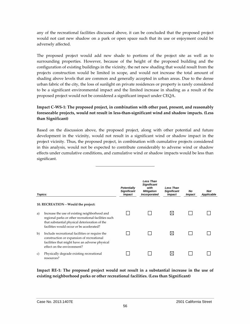
Case No. 2013.1407E 2501 California Street 56
any of the recreational facilities discussed above, it can be concluded that the proposed project
would not cast new shadow on a park or open space such that its use or enjoyment could be
adversely affected.
The proposed project would add new shade to portions of the project site as well as to
surrounding properties. However, because of the height of the proposed building and the
configuration of existing buildings in the vicinity, the net new shading that would result from the
projects construction would be limited in scope, and would not increase the total amount of
shading above levels that are common and generally accepted in urban areas. Due to the dense
urban fabric of the city, the loss of sunlight on private residences or property is rarely considered
to be a significant environmental impact and the limited increase in shading as a result of the
proposed project would not be considered a significant impact under CEQA.
Impact C‐WS‐1: The proposed project, in combination with other past, present, and reasonably
foreseeable projects, would not result in less‐than‐significant wind and shadow impacts. (Less
than Significant)
Based on the discussion above, the proposed project, along with other potential and future
development in the vicinity, would not result in a significant wind or shadow impact in the
project vicinity. Thus, the proposed project, in combination with cumulative projects considered
in this analysis, would not be expected to contribute considerably to adverse wind or shadow
effects under cumulative conditions, and cumulative wind or shadow impacts would be less than
significant.
Topics:
Potentially Significant
Impact
Less Than Significant
with Mitigation
Incorporated
Less Than Significant
Impact No
Impact Not
Applicable
10. RECREATION—Would the project:
a) Increase the use of existing neighborhood and
regional parks or other recreational facilities such
that substantial physical deterioration of the
facilities would occur or be accelerated?
b) Include recreational facilities or require the
construction or expansion of recreational
facilities that might have an adverse physical
effect on the environment?
c) Physically degrade existing recreational
resources?
Impact RE‐1: The proposed project would not result in a substantial increase in the use of
existing neighborhood parks or other recreational facilities. (Less than Significant)
Case No. 2013.1407E 2501 California Street 57
The nearest recreation facilities to the project site are: the Alta Plaza Park, located at Jackson and
Steiner Streets (approximately 800 feet from the project site); the Hamilton Playground, located at
Geary Boulevard, between Scott and Steiner Streets (approximately 1,300 feet from the project
site); and the Cottage Row Mini Park, which extends between Bush and Sutter Streets on a block
bounded by Fillmore Street to the west and Webster Street to the east (approximately 1,100 feet
from the project site). The proposed project would include automotive and commercial uses only,
and would only minimally increase the use of recreational facilities and parks due to a slight
increase in employees on the project site. Therefore, impact on recreational activities and facilities
would be less than significant.
Impact RE‐2: The proposed project would not require the construction of recreational facilities
that may have a significant effect on the environment. (Less than Significant)
The proposed project would result in a negligible increase in the demand for existing recreational
facilities and parks in the project vicinity due to an increase of employees working on the project
site. The proposed project would not necessitate the construction of new recreational facilities or
the expansion of existing facilities. Therefore, the implementation of the project would not have a
significant impact related to construction of recreational facilities.
Impact RE‐3: The proposed project would not physically degrade existing recreational
facilities. (Less than Significant)
The proposed project would not result in the physical alteration of any recreational resource
within the project site vicinity or in the City as a whole. As mentioned above, the implementation
of the proposed project would minimally increase the demand for recreational facilities and
parks. As a result, the project would not physically degrade any exiting recreational resources.
Impact C‐RE‐1: The proposed project, in combination with past, present, and reasonable
foreseeable future projects, would not considerably contribute to recreational impacts in the
project site vicinity. (Less than Significant)
The use of recreational facilities in the project site vicinity is not expected to noticeably increase as
a result of the proposed project. As mentioned above, the propose project includes automotive
and commercial uses only, and would negligibly increase the demand for recreational facilities
and parks. Therefore, the contribution of the proposed project to cumulative recreation‐related
impacts would be less than significant.
Topics:
Potentially Significant
Impact
Less Than Significant
with Mitigation
Incorporated
Less Than Significant
Impact No
Impact Not
Applicable
11. UTILITIES AND SERVICE SYSTEMS—
Would the project:
Case No. 2013.1407E 2501 California Street 58
Topics:
Potentially Significant
Impact
Less Than Significant
with Mitigation
Incorporated
Less Than Significant
Impact No
Impact Not
Applicable
a) Exceed wastewater treatment requirements of
the applicable Regional Water Quality Control
Board?
b) Require or result in the construction of new
water or wastewater treatment facilities or
expansion of existing facilities, the construction
of which could cause significant environmental
effects?
c) Require or result in the construction of new
storm water drainage facilities or expansion of
existing facilities, the construction of which
could cause significant environmental effects?
d) Have sufficient water supply available to serve
the project from existing entitlements and
resources, or require new or expanded water
supply resources or entitlements?
e) Result in a determination by the wastewater
treatment provider that would serve the project
that it has inadequate capacity to serve the
project’s projected demand in addition to the
provider’s existing commitments?
f) Be served by a landfill with sufficient permitted
capacity to accommodate the project’s solid
waste disposal needs?
g) Comply with federal, state, and local statutes
and regulations related to solid waste?
Impact UT‐1: The proposed project would not significantly affect wastewater collection and
treatment facilities and would not require or result in the construction of new stormwater
drainage facilities or expansion of existing facilities. (Less than Significant)
Project‐related wastewater and stormwater would continue to flow into the City’s combined
stormwater and sewer system and would be treated to the standards contained in the City’s
National Pollutant Discharge Elimination System (NPDES) Permit for the Southeast Water
Pollution Control Plant, prior to discharge into the San Francisco Bay. Additionally, during wet
weather events, combined wastewater and stormwater flows from the project area would be
treated at the North Point Wet Weather Facility.
The proposed project is also subject to the City’s Construction Site Runoff Control Ordinance,
which requires any project within San Francisco disturbing 5,000 square feet or more to apply for
a Construction Site Runoff Control Permit and to submit and receive approval of an Erosion and
Sediment Control Plan prior to commencing any construction related activities. To minimize
sediments and other pollutants from entering the combined sewer and stormwater system, an
Erosion and Sediment Control Plan, including BMPs, would be required to be prepared by the
project sponsor for the project to minimize stormwater runoff. During construction, non‐route,

Case No. 2013.1407E 2501 California Street 59
episodic, batch, or other temporary discharges to the City’s combined sewer system could
impacts the wastewater collection and treatment system; this impact is discussed under Impact
HY‐2, below.
The project would not require substantial expansion of wastewater/stormwater treatment
facilities or an extension of a sewer trunk line because the site is currently served by existing
facilities. Additionally, compliance with the Stormwater Management Ordinance53 in general
would require the project to maintain or reduce the existing volume and rate of stormwater
runoff discharged from the site. To achieve this, the project sponsor would implement and install
appropriate stormwater management systems that retain runoff on‐site, promote stormwater
reuse, and limit site discharges entering the combined sewer collection system. This, in turn,
would limit the incremental demand on both the collection system and wastewater facilities
resulting from stormwater discharges, and minimize the potential for upsizing or constructing
new facilities. As no new wastewater/stormwater infrastructure would be required to serve the
project, this impact would be less than significant.
Impact UT‐2: The proposed project would not require expansion or construction of new water
supply or treatment facilities. (Less than Significant)
Under Senate Bill 610 and Senate Bill 221, all large‐scale projects in California subject to CEQA
are required to obtain an assessment from a regional or local jurisdiction water agency to
determine the availability of a long‐term water supply sufficient to satisfy project‐generated
water demand.54 Under Senate Bill 610, a Water Supply Assessment (WSA) is required if a
proposed project is subject to CEQA review in an Environmental Impact Report (EIR) or
Negative Declaration and is any of the following: (1) a residential development of more than 500
dwelling units; (2) a shopping center of business employing more than 1,000 persons or having
more than 500,000 square feet of floor space; (3) a commercial office building employing more
than 1,000 persons or having more than 250,000 square feet of floor space; (4) a hotel or motel
with more than 500 rooms; (5) an industrial or manufacturing establishment housing more than
1,000 persons or having more than 650,000 square feet or 40 acres; (6) a mixed‐use project
containing any of the foregoing; or (7) any other project that would have a water demand at least
equal to a 500‐dwelling‐unit project. The proposed project would not exceed any of these
thresholds, and therefore would not be required to prepare a WSA.
In connection with the 2005 Urban Water Management Plan, the San Francisco Public Utilities
Commission (SFPUC) adopted a resolution finding that the SFPUC’s Urban Water Management
Plan (UWMP) adequately fulfills the requirements of the water assessment for water quality and
wastewater treatment and capacity as long as a project is covered by the demand projections
identified in the UWMP, which includes all known or expected development projects and
projected development in San Francisco at that time through 2020. The UWMP used growth
53 San Francisco Public Utility Commission (SFPUC). Stormwater Management Ordinance. Available online at:
http://www.sfwater.org/index.aspx?page=446. Accessed August 28, 2014. 54 California Department of Water Resources. Guidebook for Implementation of Senate Bill 610 and Senate Bill 221 of 2001,
October, 2003. Available online at: http://www.water.ca.gov/pubs/use/sb_610_sb_221_guidebook/guidebook.pdf. Accessed August 28, 2014.

Case No. 2013.1407E 2501 California Street 60
projections prepared by the Planning Department and Association of Bay Area Governments
(ABAG) to estimate future water demand. The SFPUC recently published its 2010 UWMP, which
likewise relies on population projections from ABAG. The proposed project would not be
associated with any population growth. Therefore, the project would not exceed the UWMP’s
water supply projections.
The proposed project would require new water connections per the SFPUC. The proposed project
would use existing water infrastructure unless the SFPUC recommends changes to the size and
design of this infrastructure.
Although the proposed project would incrementally increase the demand for water in San
Francisco, the estimated increase would be accommodated within the City’s anticipated water
use and supply projections. Since the proposed water demand could be accommodated by
existing and planned water supply anticipated under the SFPUC’s 2010 UWMP and the proposed
project would include water conservation devices, it would not result in a substantial increase in
water use and could be served from existing water supply entitlements and resources. Moreover,
the proposed project would also be subject to the Commercial Water Conservation Ordinance,
which requires water conservation measures and improvements for all commercial properties
upon major improvements.55 Considering all of the above, the proposed project would result in
less‐than‐significant project‐specific and cumulative water supply impacts.
Impact UT‐3: The proposed project would be served by a landfill with sufficient permitted
capacity to accommodate the project’s solid waste disposal needs. (Less than Significant)
The majority of solid waste generated by the City and County of San Francisco is transported to
the Altamont Landfill. As of March 2013, San Francisco’s remaining capacity at the landfill was
1,052,815 tons out of the original 15 million ton capacity.56 At current disposal rates, San
Francisco’s available landfill space under the existing contract will run out in January 2015.
However, as of the year 2005 (latest year of record), the landfill has a closure date in 2025 and a
remaining capacity of 74 percent.57 San Francisco Ordinance No. 27‐06 requires a minimum of 65
percent of all construction and demolition debris to be recycled and diverted from landfills. San
Francisco had a goal of 75 percent solid waste diversion by 2010 and has a goal of 100 percent
solid waste diversion by 2020. San Francisco diverted 80 percent of their solid waste in the year
2010.58
With implementation of the proposed project, new trash receptacles would be in place at the
project site and site customers and employees would participate in the City’s recycling and
composting programs and other efforts to reduce the solid waste disposal stream. Due to the
55 San Francisco Public Utilities Commission, Residential Water Conservation Ordinance Amendments. Available online:
http://sfwater.org/index.aspx?page=454. Accessed December 23, 2014.
56 San Francisco Department of the Environment (DOE), “Zero Waste FAQ.” Available online at:
http://www.sfenvironment.org/zero‐waste/overview/zero‐waste‐faq. Accessed October 7, 2014.
57 CalRecycle, “Active Landfills Profile for Altamont Landfill and Resource Recv’ry (01‐AA‐0009).” Available online at:
http://www.calrecycle.ca.gov/SWFacilities/Directory/01‐AA‐0009/Detail/. Accessed August 1, 2013.
58 DOE, “Mayor Lee Announces San Francisco Reaches 80 Percent Landfill Waste Diversion, Leads All Cities in North
America.” Available online at: http://www.sfenvironment.org/zerowaste/overview/goals. Accessed August 1, 2013.

Case No. 2013.1407E 2501 California Street 61
existing and anticipated increase of solid waste recycling in the City and the Altamont Landfill’s
remaining capacity, any increase in solid waste from the project site would be accommodated by
the existing landfill and thus would have less‐than‐significant impacts on solid waste facilities.
The proposed project would be in compliance with City Ordinance 100‐09, the Mandatory
Recycling and Composting Ordinance, which requires everyone in San Francisco to separate their
refuse into recyclables, compostables, and trash. The project would also be subject to the City’s
Construction and Demolition Debris Recovery Ordinance, which requires all construction and
demolition debris to be transported to a registered facility that can divert a minimum of 65
percent of the material from landfills. Therefore, the project’s impact on existing landfill capacity
would be less than significant.
Given the existing and anticipated increase in solid waste recycling, the project would have a
less‐than‐significant impact on solid waste facilities. Therefore, the project’s impact on existing
landfill capacity would be less than significant.
Impact UT‐4: The construction and operation of the proposed project would follow all
applicable statutes and regulations related to solid waste. (Less than Significant)
The California Integrated Waste Management Act of 1989 (Assembly Bill 939) requires
municipalities to adopt an Integrated Waste Management Plan to establish objectives, policies,
and programs relative to waste disposal, management, source reduction, and recycling. San
Francisco Ordinance No. 27‐06 requires a minimum of 65 percent of all construction and
demolition debris to be recycled and diverted from landfills. San Francisco Ordinance No. 100‐09
requires everyone in San Francisco to separate their solid waste into recyclables, compostables,
and trash. The proposed project would be subject to and would comply with San Francisco
Ordinance No. 27‐06, San Francisco Ordinance No. 100‐09 and all other applicable statutes and
regulations related to solid waste. Therefore, the proposed project’s impact to solid waste would
be less than significant.
Impact C‐UT‐1: The proposed project would not make a considerable contribution to any
cumulative significant effects related to utilities or service systems. (Less than Significant)
Cumulative development in the project site vicinity would incrementally increase demand on
citywide utilities and service systems, but not beyond levels anticipated and planned for by
public service providers. Given that the Cityʹs existing service management plans address
anticipated growth in the region, the proposed project would not be expected to have a
considerable effect on utility service provision or facilities under cumulative conditions.
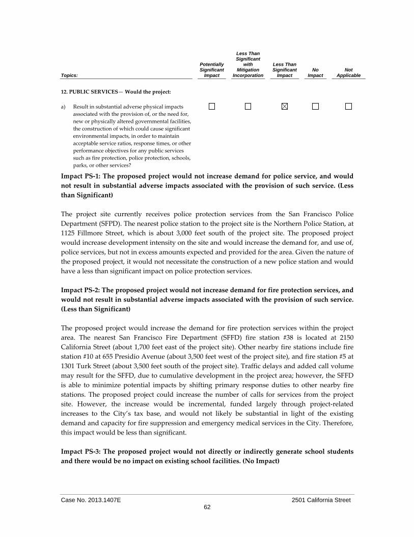
Case No. 2013.1407E 2501 California Street 62
Topics:
Potentially Significant
Impact
Less Than Significant
with Mitigation
Incorporation
Less Than Significant
Impact No
Impact Not
Applicable
12. PUBLIC SERVICES— Would the project:
a) Result in substantial adverse physical impacts
associated with the provision of, or the need for,
new or physically altered governmental facilities,
the construction of which could cause significant
environmental impacts, in order to maintain
acceptable service ratios, response times, or other
performance objectives for any public services
such as fire protection, police protection, schools,
parks, or other services?
Impact PS‐1: The proposed project would not increase demand for police service, and would
not result in substantial adverse impacts associated with the provision of such service. (Less
than Significant)
The project site currently receives police protection services from the San Francisco Police
Department (SFPD). The nearest police station to the project site is the Northern Police Station, at
1125 Fillmore Street, which is about 3,000 feet south of the project site. The proposed project
would increase development intensity on the site and would increase the demand for, and use of,
police services, but not in excess amounts expected and provided for the area. Given the nature of
the proposed project, it would not necessitate the construction of a new police station and would
have a less than significant impact on police protection services.
Impact PS‐2: The proposed project would not increase demand for fire protection services, and
would not result in substantial adverse impacts associated with the provision of such service.
(Less than Significant)
The proposed project would increase the demand for fire protection services within the project
area. The nearest San Francisco Fire Department (SFFD) fire station #38 is located at 2150
California Street (about 1,700 feet east of the project site). Other nearby fire stations include fire
station #10 at 655 Presidio Avenue (about 3,500 feet west of the project site), and fire station #5 at
1301 Turk Street (about 3,500 feet south of the project site). Traffic delays and added call volume
may result for the SFFD, due to cumulative development in the project area; however, the SFFD
is able to minimize potential impacts by shifting primary response duties to other nearby fire
stations. The proposed project could increase the number of calls for services from the project
site. However, the increase would be incremental, funded largely through project‐related
increases to the City’s tax base, and would not likely be substantial in light of the existing
demand and capacity for fire suppression and emergency medical services in the City. Therefore,
this impact would be less than significant.
Impact PS‐3: The proposed project would not directly or indirectly generate school students
and there would be no impact on existing school facilities. (No Impact)
Case No. 2013.1407E 2501 California Street 63
The proposed project involves the construction of a fueling station and a convenience store,
which would replace an existing fueling station, convenience store and automotive service
station. The project does not include construction of any dwelling units. Therefore, the proposed
project would not contribute to the need for new school facilities, and would result in no impacts
related to schools.
Impact PS‐4: The proposed project would not increase demand for parks, and there would be
no impact on parks. (Less than Significant)
The nearest recreation facilities to the project site are: the Alta Plaza Park, located at Jackson and
Steiner Streets (approximately 800 feet from the project site); the Hamilton Playground, located at
Geary Boulevard, between Scott and Steiner Streets (approximately 1,300 feet from the project
site); and the Cottage Row Mini Park, which extends between Bush and Sutter Streets on a block
bounded by Fillmore Street to the west and Webster Street to the east (approximately 1,100 feet
from the project site). All of these facilities are located within one‐half mile of the project site.
Although new employees may utilize parks and recreational spaces in the vicinity of the project
site, the use would likely be modest (based on projected employment), and it is unlikely that
substantial physical deterioration would be expected. In addition, the proposed project would
not substantially increase demand for or use of citywide facilities such as the Golden Gate Park or
the waterfront. Therefore, this impact would be less than significant.
Impact PS‐5: The proposed project would increase demand for government services, but not to
the extent that would result in significant physical impacts. (Less than Significant)
The proposed project would not include residential uses. Therefore, the proposed project would
not increase the demand for libraries, community centers, and other public facilities, and the
project would not have an impact on governmental services.
Impact C‐PS‐1: The proposed project, combined with past, present, and reasonably foreseeable
future projects in the vicinity, would not have a substantial cumulative impact to public
services. (Less than Significant)
The proposed project is not expected to significantly increase demand for public services,
especially not beyond levels anticipated and planned for by public service providers. Cumulative
development in the project area would incrementally increase demand for public services, but
not beyond levels anticipated and planned for by public service providers. Thus, project‐related
impacts to public services would not be cumulatively considerable.

Case No. 2013.1407E 2501 California Street 64
Topics:
Potentially Significant
Impact
Less Than Significant
with Mitigation
Incorporation
Less Than Significant
Impact No
Impact Not
Applicable
13. BIOLOGICAL RESOURCES—
Would the project:
a) Have a substantial adverse effect, either directly
or through habitat modifications, on any species
identified as a candidate, sensitive, or special‐
status species in local or regional plans, policies,
or regulations, or by the California Department
of Fish and Game or U.S. Fish and Wildlife
Service?
b) Have a substantial adverse effect on any riparian
habitat or other sensitive natural community
identified in local or regional plans, policies,
regulations or by the California Department of
Fish and Game or U.S. Fish and Wildlife Service?
c) Have a substantial adverse effect on federally
protected wetlands as defined by Section 404 of
the Clean Water Act (including, but not limited
to, marsh, vernal pool, coastal, etc.) through
direct removal, filling, hydrological interruption,
or other means?
d) Interfere substantially with the movement of any
native resident or migratory fish or wildlife
species or with established native resident or
migratory wildlife corridors, or impede the use
of native wildlife nursery sites?
e) Conflict with any local policies or ordinances
protecting biological resources, such as a tree
preservation policy or ordinance?
f) Conflict with the provisions of an adopted
Habitat Conservation Plan, Natural Community
Conservation Plan, or other approved local,
regional, or state habitat conservation plan?
BI‐1: The proposed project would have no impact on special status species, avian species,
riparian, wetland, or sensitive natural communities, and would not conflict with an approved
local, regional, or state habitat construction plan. (Less than Significant)
The project site is not located near any riparian habitat, sensitive natural community, federally
protected wetlands or adopted conservation plan. There is no potential for the proposed project
to affect adversely special‐status species or sensitive natural communities, including wetlands.
Migrating birds do pass through San Francisco, but the project site does not contain habitat to
support migrating birds. Nesting birds, their nests, and eggs are fully protected by Fish and
Game Code (Sections 3503, 3503.5) and the federal Migratory Bird Treaty Act (MBTA). The
proposed project would be subject to the MBTA, and would therefore have a less‐than‐significant

Case No. 2013.1407E 2501 California Street 65
impact to nesting birds. The project site is almost entirely covered with impervious surfaces. The
project site is located in a highly urbanized environment with light industrial, office, and PDR
uses and few street trees. In light of the above, the proposed project’s impact on biological
resources would be less than significant.
BI‐2: The proposed project would not conflict with the City’s local tree ordinance. (Less than
Significant)
There are no trees on the project site and no street trees within the right‐of‐way along the project
site frontage on California or Steiner Streets.59 As part of this project, a total of 12 street trees (five
along California Street and seven along Steiner Street) would be required pursuant to Planning
Code Section 138.1, the Better Streets Plan, and in accordance with the MBTA. Planning Code
Section 138.1 requires new construction, significant alterations, or relocation of building projects
within any zoning district to include the planting of one 24‐inch box tree for every 20 feet along
the project site’s street or alley frontage, with any remaining fraction of 10 feet or more requiring
an additional tree. The trees must be planted in conformance with the City’s recently adopted
Better Streets Plan, including conformance with the street tree goals for a particular street type.
Trees are not allowed above or within five feet of the outside diameter of wastewater assets or
lateral vents.
Given that the proposed project would have a significant portion of the site’s frontage taken up
by curb cuts/driveways, it would not be feasible to plant 12 street trees along the project site
frontages. While Planning Department has jurisdiction over provision of street trees, the
Department of Public Works (DPW) has jurisdiction over the trees in question. In any case in
which the Department of Public Works cannot grant approval for installation of a tree in the
public right‐of‐way, on the basis of inadequate sidewalk width, interference with utilities or other
reasons regarding the public welfare, and where installation of such tree on the lot itself is
impractical, the tree planting requirements of this Section 138.1(c)(1) may be modified or waived
by the Zoning Administrator. In the event that fewer trees can be accommodated on the project
site than required by Planning Code Section 138.1, for each tree that the Zoning Administrator
waives, the applicant shall pay an ʺin‐lieuʺ street tree fee pursuant to Section 428.
DPW staff has indicated that six street trees cannot be approved and that eligible sidewalk
landscaping has not been proposed as an alternate means of compliance.60 Accordingly, the in‐
lieu street tree fee would apply to six required street trees which cannot be approved. A Zoning
Administrator approval will be required for this modification. A total of six street trees would be
planted as part of the proposed project – five trees on Steiner Street and one tree on California
Street.
59 Muthana Ibrahim, MI Architects, Inc., Project Sponsor. Tree Planting and Protection, 2501 California Street,
September 20, 2013. This document is available for public review as part of Case No. 2013.1407E at 1650 Mission Street, Suite 400, San Francisco, CA 94103.
60 Department of Public Works, Bureau of Urban Forestry, Feasibility of Tree Planting or Removal, 2501 California Street, October 1, 2014. This document is available for public review as part of Case No. 2013.1407E at 1650 Mission Street, Suite 400, San Francisco, CA 94103.

Case No. 2013.1407E 2501 California Street 66
The project sponsor would comply with local regulations regarding tree planting, through a
combination of planting trees along the adjacent sidewalks and by paying the in‐lieu street tree
fee pursuant to Section 428. For these reasons, the project would therefore not conflict with the
City’s Urban Forestry Ordinance, and would not result in significant impacts related to tree
protection.
C‐BI‐1: The proposed project in combination with other past, present or reasonably
foreseeable projects, would not result in impacts to biological resources. (Less than
Significant)
As discussed above, the project site does not contain biological resources, and the project vicinity
has few street trees, which do not provide a habitat for endangered or threatened plant or animal
species. Therefore, the project would not impact such species and would not have the potential to
contribute to cumulative impacts on biological resources.
In summary, the proposed project would not have significant impacts on special‐status species,
avian species, riparian, wetland, or sensitive natural communities; would not conflict with an
approved local, regional, or state habitat conservation plan or tree protection ordinance; and
would have less‐than‐significant cumulative impact on biological resources.
Topics:
Potentially Significant
Impact
Less Than Significant
with Mitigation
Incorporated
Less Than Significant
Impact No
Impact Not
Applicable
14. GEOLOGY AND SOILS—
Would the project:
a) Expose people or structures to potential
substantial adverse effects, including the risk of
loss, injury, or death involving:
i) Rupture of a known earthquake fault, as
delineated on the most recent Alquist‐
Priolo Earthquake Fault Zoning Map issued
by the State Geologist for the area or based
on other substantial evidence of a known
fault? (Refer to Division of Mines and
Geology Special Publication 42.)
ii) Strong seismic ground shaking?
iii) Seismic‐related ground failure, including
liquefaction?
iv) Landslides?
b) Result in substantial soil erosion or the loss of
topsoil?

Case No. 2013.1407E 2501 California Street 67
Topics:
Potentially Significant
Impact
Less Than Significant
with Mitigation
Incorporated
Less Than Significant
Impact No
Impact Not
Applicable
c) Be located on geologic unit or soil that is
unstable, or that would become unstable as a
result of the project, and potentially result in on‐
or off‐site landslide, lateral spreading,
subsidence, liquefaction, or collapse?
d) Be located on expansive soil, as defined in
Table 18‐1‐B of the Uniform Building Code,
creating substantial risks to life or property?
e) Have soils incapable of adequately supporting
the use of septic tanks or alternative wastewater
disposal systems where sewers are not available
for the disposal of wastewater?
f) Change substantially the topography or any
unique geologic or physical features of the site?
Checklist item 14e does not apply, as the proposed project does not include the use of septic
tanks or alternative wastewater disposal systems. The proposed project would connect to and
would be served by the City’s combined stormwater and sewer system. Therefore, this subtopic
is not applicable to the proposed project and is not discussed below.
A Preliminary Geotechnical Evaluation was prepared for the project site; the results and
recommendations outlined therein are summarized below.61 The purpose of the Preliminary
Geotechnical Evaluation is to develop recommendations regarding the geotechnical aspects of
project design and construction. To obtain pertinent information regarding subsurface soil and
groundwater conditions, three cone penetrometer tests (CPTs) were advanced to depths of
approximately 30 feet below ground surface (bgs) each.
The Preliminary Geotechnical Evaluation indicates that, based on the results on the CPTs, the site is
primarily underlain by medium dense to dense mixtures of sand and silt with few exceptions.
The subsurface soil was interpreted to be loose between approximately 4 to 7 feet bgs in CPT‐1,
2.5 feet to 5 feet in CPT‐2, and 2 to 6 feet in CPT‐3. A layer of silty clay to clay was encountered
between 29 feet and the maximum depth (30 feet in CPT‐2) and 26 feet to the maximum depth (30
feet) in CPT‐3.
The groundwater level in the site vicinity was encountered at about 24 feet. However, historic
high water table in the general site area is about 10 to 30 feet in depth and water may fluctuate
seasonally. Thus, localized shallow perched water table could develop during the rainy seasons.
Project excavation for the proposed 2051 California Street project is expected to be approximately
10 feet below grade and approximately 1,200 cubic yards of soil would be removed from the
61
BAGG Engineers, Geotechnical Engineering Investigation, Proposed Shell Gas Station & Loop Convenience Store, 2501 California Street, San Francisco, California, October 2013 (hereinafter “Preliminary Geotechnical Evaluation”). A copy of this document is available for review at the San Francisco Planning Department, 1650 Mission Street, Suite 400 as part of Case File 2013.1407E.

Case No. 2013.1407E 2501 California Street 68
project site to accommodate the proposed basement below the convenience store as well as the
new fuel tanks. Preliminary design recommendations indicate that the proposed convenience
store building can be supported on conventional spread/strip footings. The partial basement area
below the convenience store may be supported on a concrete mat foundation and the fueling
canopy may be supported on drilled, cast‐in‐place, reinforced concrete piers.
Impact GE‐1: The proposed project would not result in the exposure of persons or structures
to seismically‐induced geologic hazards, i.e., rupture of a known earthquake fault, strong
seismic ground shaking, ground failure, and landslides. (Less than Significant)
Fault Rupture
The Alquist‐Priolo Earthquake Fault Zoning Act’s main purpose is to prevent the construction of
buildings used for human occupancy on the surface trace of active faults. The project site is not
located within an Alquist‐Priolo Earthquake Fault Zone as established by the California
Geological Survey (CGS), and no active or potentially active faults exist on or in the immediate
vicinity of this site.62 Therefore, the potential for surface fault rupture is low, and this impact
would be less than significant.
Ground Shaking
Like the rest of the San Francisco Bay Area, the project site is subject to ground shaking in the
event of an earthquake on regional fault lines. The United States Geological Survey (USGS)
estimates that there is a 63 percent probability of a strong earthquake (Moment magnitude63 [Mw]
6.7 or higher) occurring in the San Francisco Bay region during the 30‐year period between 2007
and 2036.64 The nearest faults that could cause substantial ground shaking in the project area are
the San Andreas Fault, located approximately 11.8 kilometers west‐southwest of the project site;
the San Gregorio Fault, located approximately 16.1 kilometers west‐southwest of the project site;
and the Hayward Fault, located approximately 18.8 kilometers east of the project site.
The Association of Bay Area Governments (ABAG) has prepared maps that show areas of the
City subject to ground shaking during an earthquake. The project site is in an area subject to
“very strong” ground shaking from a major earthquake along the Peninsula segment of the San
Andreas Fault and “strong” ground shaking from a major earthquake along the northern
Hayward Fault, the two faults closet to the project site.65
Although the potential for “strong” to “very strong” seismic ground shaking is present, the
intensity of earthquake ground motion in the vicinity of the project site would depend on the
characteristics of the generating fault, the distance to the earthquake’s epicenter, the magnitude
62 California Geological Survey, Table 4, Cities and Counties Affected by Alquist‐Priolo Earthquake Fault Zones as of
January 2010. Available online at http://www.consrv.ca.gov/cgs/rghm/ap/Pages/affected.aspx. Accessed September
2, 2014.
63 An earthquake is classified by the amount of energy released, expressed as the magnitude of the earthquake.
Traditionally, magnitudes have been quantified using the Richter scale. However, seismologists now use a moment
magnitude (Mw) scale because it provides a more accurate measurement of the size of major and great earthquakes.
64 United States Geological Survey, Earthquake Hazards Program. Available online at
http://earthquake.usgs.gov/regional/nca/ucerf/. Accessed October 7, 2014. 65 Association of Bay Area Governments, Earthquake and Hazards Program, Hazard Maps and Information, Earthquake
Shaking, Future Earthquake Shaking Scenarios, Static Shaking Maps for Future Earthquake Scenarios. Available
online at http://www.abag.ca.gov/cgi‐bin/pickmapx.pl. Accessed September 2, 2014.

Case No. 2013.1407E 2501 California Street 69
and duration of the earthquake, and site geologic conditions. In the event of an earthquake that
exhibits “strong” to “very strong” seismic ground shaking, considerable damage could occur to
existing buildings on the project site, potentially injuring building occupants and neighbors. The
proposed structures would be designed in accordance with the site‐specific recommendations
determined by a site‐specific design‐level geotechnical investigation and would be constructed in
conformance with accepted building and engineering standards, thereby ensuring the new
structures would withstand seismic damage from “strong” or “very strong” ground shaking.
The final plans for the proposed building would be reviewed by the Department of Building
Inspection (DBI), ensuring that seismically‐induced ground shaking would be addressed in the
building design process. DBI would also review the proposed building permit applications for
compliance with the 2010 San Francisco Building Code, and for implementation of
recommendations in the site‐specific design‐level geotechnical investigation that address seismic
hazards. Damage and injury from ground shaking cannot be entirely avoided; however,
adherence to current commercial and regulatory practices, including building code requirements,
can reduce the potential for injury and damage. Therefore, the proposed project would not
expose persons or structures to substantial adverse effects related to ground shaking and the
impact would be less than significant.
Liquefaction, Lateral Spreading, and Seismic Settlement
Strong shaking during an earthquake can cause ground failure as a result of soil liquefaction,
lateral spreading, or seismic settlement. Liquefaction refers to the loss of strength of saturated
soils during ground shaking. Lateral spreading is horizontal ground movement of relatively flat‐
lying soil deposits towards a free face such as an excavation and is generally associated with
liquefaction of subsurface soils at or near the bottom of an exposed surface. Seismic densification
is a phenomenon in which non‐saturated, cohesionless soil is densified by earthquake vibrations,
causing differential settlement.
The project site is not located in an area of liquefaction potential as identified in the Seismic
Hazards Zone Map for the City and County of San Francisco.66 As discussed above, a review of
subsurface conditions in the project area indicates that the soil below the groundwater consists
primarily of medium dense to dense sand and silt. The planned excavations would extend below
the loose sands above the water table. Therefore, the potential for liquefaction and lateral
spreading at the site would be low as would the potential for seismic settlement. Based on this
information, the potential for liquefaction, lateral spreading, and seismic settlement at the project
site is low.
To ensure compliance with all San Francisco Building Code provisions regarding structural
safety, when DBI reviews the site‐specific design‐level geotechnical investigation and building
plans for a proposed project, it will determine necessary engineering and design features for the
project to reduce potential damage to structures from liquefaction, lateral spreading, and seismic
settlement. DBI could require that additional site‐specific soils report(s) be prepared in
66 California Geological Survey, Seismic Hazards Zonation Program, City and County of San Francisco Quadrangle,
November 17, 2000. Available online at http://gmw.consrv.ca.gov/shmp/download/pdf/ozn_sf.pdf. Accessed
September 2, 2014.
Case No. 2013.1407E 2501 California Street 70
conjunction with the building permit applications. Therefore, potential damage to structures
from geologic hazards on a project site would be minimized through the DBI requirement for a
site‐specific design‐level geotechnical investigation and review of the building permit application
pursuant to its implementation of the Building Code. Any changes incorporated into the
foundation design required to meet the Building Code standards that are identified as a result of
the DBI permit review process would constitute minor modifications of the project and would
not require additional environmental analysis.
Therefore, the proposed excavation and building construction on the project site would result in
less‐than‐significant impacts related to the potential for ground failure as a result of liquefaction,
lateral spreading, and seismic settlement.
Seismically Induced Landslides
The project site is relatively flat. The exception to this is the southeastern portion of the project
site, which is separated from the adjacent Steiner Street sidewalk by approximately three feet (an
approximately 10‐foot retaining wall segment supports that portion of the site). The project site
is not located within or near an area of seismically induced landslide susceptibility as identified
in the Seismic Hazards Zone Map for the City and County of San Francisco.67 Therefore, impacts
related to seismically induced landslides would not be applicable and no further analysis or
discussion is required.
Impact GE‐2: The proposed project would not cause soil erosion or the loss of topsoil. (Less
than Significant)
The project site is almost fully covered by impervious surfaces. Implementation of the proposed
project would require excavation to a depth of about 10 feet below the existing ground surface.
Soil movement for site preparation and excavation activities could create the potential for wind‐
and water‐borne soil erosion. The majority of the project site is relatively flat, although as noted
above, there is an approximately three foot difference in elevation between the southeastern
portion of the project site and the adjacent Steiner Street sidewalk. Regardless, substantial erosion
would not be expected as a result of these activities. Furthermore, the construction contractor
would be required to implement an erosion and sediment control plan for construction activities,
in accordance with Article 4.1 of the San Francisco Public Works Code, to address sediment‐laden
construction‐site stormwater runoff, as discussed in Initial Study Topic E.15, Hydrology and
Water Quality. The SFPUC must review and approve the erosion and sediment control plan
prior to the plan’s implementation, and SFPUC would inspect the project site periodically to
ensure compliance with the plan. Therefore, impacts related to soil erosion would be less than
significant.
Impact GE‐3: The proposed project would not be located on a geologic unit or soil that is
unstable or that would become unstable as a result of the project construction or potentially
67 California Geological Survey, Seismic Hazards Zonation Program, City and County of San Francisco Quadrangle,
November 17, 2000. Available online at http://gmw.consrv.ca.gov/shmp/download/pdf/ozn_sf.pdf. Accessed
September 2, 2014.

Case No. 2013.1407E 2501 California Street 71
result in on‐ or off‐site landslides, lateral spreading, subsidence, liquefaction, or collapse.
(Less than Significant)
As discussed under Impact GE‐1, the potential for liquefaction, lateral spreading, seismic
settlement, and landslides on the project site is low, indicating that the project site is likely not
located on a geologic unit or soil that is unstable. Implementation of the proposed project would
require excavation to a depth of approximately 10 feet below the existing ground surface. The
Preliminary Geotechnical Evaluation indicates that the proposed project is feasible from a
geotechnical engineering standpoint, provided that recommendations articulated in that report
are incorporated into the project design.
The Preliminary Geotechnical Evaluation indicates that the main geotechnical concern at the site is
the lack of clay binder in the soils. Therefore, it recommends immediately shoring excavations
deeper than 3 feet. The report also indicates that the proposed convenience store can be
supported on conventional spread/strip footings, the partial basement area below the
convenience store may be supported on a concrete mat foundation, and the fueling canopy may
be supported on drilled, cast‐in‐place, reinforced concrete piers. The report also provides specific
recommendations for site grading, foundations, retaining walls, slabs‐on‐grade, flexible and rigid
pavements, drainage, and utility trench backfill. The project sponsor has agreed to incorporate
the Preliminary Geotechnical Evaluation recommendations into the project design. The proposed
project would be required to conform to the San Francisco Building Code, which ensures the
safety of all new construction in the City. Decisions about appropriate foundation design and
whether additional background studies are required would be considered as part of the DBI
review process. Given that the project is not located in a location that is subject to landslides,
lateral spreading, subsidence, liquefaction, or collapse, and given that final structural design
would be subject to DBI review and approval, the potential for project construction to potentially
result in on‐ or off‐site landslides, lateral spreading, subsidence, liquefaction, or collapse would
be low and this impact would be less than significant.
Impact GE‐4: The proposed project would not be located on expansive soils creating
substantial risks to life or property. (No Impact)
The City and County of San Francisco is within an area where less than 50 percent of the soil
consists of clay having high swelling potential, i.e., expansive soils. Expansive soils are those that
shrink or swell substantially with changes in moisture content and generally contain a high
percentage of clay particles. Based on the results of the cone penetrometer tests, the site is
primarily underlain by medium dense to dense mixtures of sand and silt, although a layer of silty
clay to clay was encountered beneath the site at approximately 26 feet bgs and lower. However,
the structural recommendations contained in the Preliminary Geotechnical Report, including
conventional spread/strip footings for the proposed convenience store, a concrete mat foundation
for the partial basement area below the convenience store, and drilled, cast‐in‐place, reinforced
concrete piers for the fueling canopy, would ensure that any impacts related to presence of
expansive soils beneath the site would be reduced to a less than significant level. Moreover, in
accordance with design BMPs, surface runoff would be directed away from foundations and
moisture infiltration would be limited. Impacts related to expansive soils would thus be less than
significant.

Case No. 2013.1407E 2501 California Street 72
Impact GE‐5: The proposed project would not substantially alter site topography or unique
geologic or physical features of the project site. (No Impact)
The project site is located in a developed urban area in the Western Addition neighborhood. The
site is occupied by a fueling station (a structure which includes one fueling canopy with three
fueling dispensers), three underground storage tanks and a structure containing a convenience
store and an automotive service station. The proposed project would merge the three lots into
one, remove all existing above‐ and below‐ground structures on the site, and construct a 19‐foot‐
tall, approximately 2,600‐sf fueling canopy with five fueling dispensers (each dispenser
containing two pumps each, one on each side); two underground storage tanks and associated
underground pipes; and a structure containing an approximately 2,300‐sf convenience store on
the ground level with approximately 2,300‐sf of storage space in a below‐grade basement. There
are no unique geologic or physical features on the project site. The proposed project would not
alter the topography or change any unique geological or physical features of the project area;
therefore, there would be no impact.
Impact C‐GE‐1: The proposed project, in combination with other past, present or reasonably
foreseeable future projects in the site vicinity, would not result in a cumulatively considerable
contribution to a significant cumulative impact on geology, soils and seismicity. (Less than
Significant)
Geology impacts are generally localized and site specific and would not combine with other
nearby projects to result in cumulative effects. Therefore, the proposed project and other
reasonably foreseeable projects would not result in a cumulative geology and soils impacts. In
addition, the building plans of proposed and foreseeable projects would be reviewed by SF DBI,
and potential geologic hazards would be avoided during the SF DBI permit review process.
Therefore, cumulative impacts related to geology, soils, and seismicity would be less than
significant.
Topics:
Potentially Significant
Impact
Less Than Significant
with Mitigation
Incorporation
Less Than Significant
Impact No
Impact Not
Applicable
15. HYDROLOGY AND WATER QUALITY—
Would the project:
a) Violate any water quality standards or waste
discharge requirements?
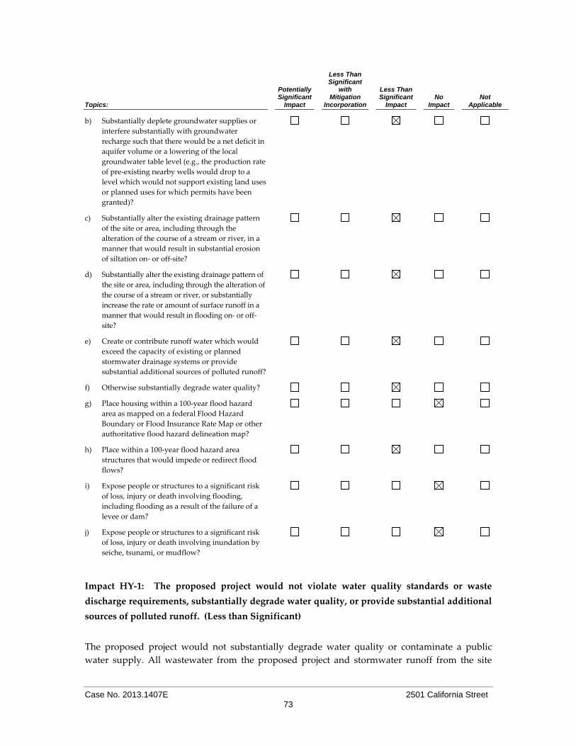
Case No. 2013.1407E 2501 California Street 73
Topics:
Potentially Significant
Impact
Less Than Significant
with Mitigation
Incorporation
Less Than Significant
Impact No
Impact Not
Applicable
b) Substantially deplete groundwater supplies or
interfere substantially with groundwater
recharge such that there would be a net deficit in
aquifer volume or a lowering of the local
groundwater table level (e.g., the production rate
of pre‐existing nearby wells would drop to a
level which would not support existing land uses
or planned uses for which permits have been
granted)?
c) Substantially alter the existing drainage pattern
of the site or area, including through the
alteration of the course of a stream or river, in a
manner that would result in substantial erosion
of siltation on‐ or off‐site?
d) Substantially alter the existing drainage pattern of
the site or area, including through the alteration of
the course of a stream or river, or substantially
increase the rate or amount of surface runoff in a
manner that would result in flooding on‐ or off‐
site?
e) Create or contribute runoff water which would
exceed the capacity of existing or planned
stormwater drainage systems or provide
substantial additional sources of polluted runoff?
f) Otherwise substantially degrade water quality?
g) Place housing within a 100‐year flood hazard
area as mapped on a federal Flood Hazard
Boundary or Flood Insurance Rate Map or other
authoritative flood hazard delineation map?
h) Place within a 100‐year flood hazard area
structures that would impede or redirect flood
flows?
i) Expose people or structures to a significant risk
of loss, injury or death involving flooding,
including flooding as a result of the failure of a
levee or dam?
j) Expose people or structures to a significant risk
of loss, injury or death involving inundation by
seiche, tsunami, or mudflow?
Impact HY‐1: The proposed project would not violate water quality standards or waste
discharge requirements, substantially degrade water quality, or provide substantial additional
sources of polluted runoff. (Less than Significant)
The proposed project would not substantially degrade water quality or contaminate a public
water supply. All wastewater from the proposed project and stormwater runoff from the site
Case No. 2013.1407E 2501 California Street 74
would flow into the City’s combined sewer system to be treated at the Southeast Water Pollution
Control Plant prior to discharge into the San Francisco Bay. Treatment would be provided
pursuant to the effluent discharge standards contained in the City’s National Pollutant Discharge
Elimination System (NPDES) Permit for the plant. Additionally, compliance with the Stormwater
Management Ordinance in general would require the project to maintain or reduce the existing
volume and rate of stormwater runoff discharged from the site. To achieve this, the project would
implement and install appropriate stormwater management systems that retain runoff on‐site,
promote stormwater reuse, and limit site discharges before entering the combined sewer
collection system.
During the proposed project’s construction, the potential for erosion and transportation of soil
particles would exist. Once in surface water runoff, sediment and other pollutants could leave
the construction site and drain into the combined sewer and stormwater system, necessitating
treatment at the Southeast Water Pollution Control Plant prior to discharge into the Bay. To
minimize sediments and other pollutants from entering the combined sewer and stormwater
system, an Erosion and Sediment Control Plan, including BMPs, would be required to be
prepared by the project sponsor for the project to minimize stormwater runoff. The Erosion and
Sediment Control Plan should be submitted to the SFPUC for review and approval. In addition,
as discussed in Section E.16 (Hazardous Materials) below, the proposed project would be subject
to and required to comply with the Maher Ordinance, which has further site management and
reporting requirements for potential hazardous soils.
The existing project site is almost entirely covered with paved surfaces (approximately 95
percent). With project implementation, the amount of impervious surfaces would be expected to
increase slightly (to 97 percent). However, the City’s Stormwater Management Ordinance
(Ordinance No. 83‐10) would require the proposed project to reduce the existing volume and rate
of stormwater runoff discharged from the project site. To achieve this, the proposed project
would implement and install appropriate stormwater management systems that retain runoff
onsite, promote stormwater reuse, and limit site discharges entering the combined sewer
collection system. This, in turn, would limit the incremental demand on both the collection
system and wastewater facilities resulting from stormwater discharges, and minimize the
potential for upsizing or constructing new facilities. Therefore, due to the requirements of
existing regulations, the proposed project would not violate water quality standards,
substantially degrade water quality, or provide substantial additional sources of polluted runoff
and impacts would be less‐than‐significant.
Impact HY‐2: The proposed project would not substantially deplete groundwater supplies or
interfere substantially with groundwater recharge such that there would be a net deficit in
aquifer volume or a lowering of the local groundwater table level. (Less than Significant)
As discussed in Topic E.14 Geology and Soils, groundwater was observed at a depth of
approximately 24 feet bgs. However, groundwater will vary with time and zones of seepage may
be encountered near the ground surface following rain or irrigation upslope of the project site.
Any groundwater that is encountered during construction of the proposed project is subject to
the requirements of the City’s Sewer Use Ordinance (Ordinance Number 19‐92, amended 116‐97),
Case No. 2013.1407E 2501 California Street 75
as supplemented by Department of Public Works (DPW) Order No. 158170, requiring a Batch
Discharge Permit from the Wastewater Enterprise Collection System Division of the San
Francisco Public Utilities Commission (SFPUC). This permit may be issued only if an effective
pretreatment system is maintained and operated. Each Batch Discharge Permit shall contain
specified water quality standards and may require the project sponsor to install and maintain
meters to measure the volume of the discharge to the combined sewer system.
The 14,180‐sf project site is currently almost entirely covered with impervious surfaces (95
percent). As a result, there is no or little recharge of groundwater at the project site. With project
implementation, the amount of impervious surfaces would be expected to increase slightly (to 97
percent). Nevertheless, the proposed project would not substantially increase the amount of
surface runoff that drains into the City’s combined sewer and stormwater drainage system.
In light of the above, groundwater resources would not be substantially depleted, and the project
would not substantially interfere with groundwater recharge.
Impact HY‐3: The proposed project would not result in altered drainage patterns that would
cause substantial erosion or flooding or contribute runoff water that would exceed the capacity
of existing or planned stormwater drainage systems or provide substantial additional sources
of polluted runoff. (Less than Significant)
As noted above, the 14,180‐sf project site is currently almost entirely covered with impervious
surfaces. The proposed project would slightly increase the amount of impermeable surfaces on
the site. However, the project would not be expected to result in a substantial change in the
drainage pattern on and near the project site.
In addition, compliance with the Stormwater Management Ordinance would require the project
to maintain or reduce the existing volume and rate of stormwater runoff at the site by retaining
runoff on‐site, promoting stormwater reuse, and limiting site discharges that enter the combined
sewer collection system. Therefore, the proposed project would not substantially alter existing
groundwater drainage patterns and would result in a less‐than‐significant impact related to
erosion or flooding.
Impact HY‐4: The proposed project would not expose people, housing, or structures to
substantial risk of loss due to flooding. (Less than Significant)
Development in the City and County of San Francisco must account for flooding potential. Flood
risk assessment and some flood protection projects are conducted by federal agencies including
the Federal Emergency Management Agency (FEMA) and the U.S. Army Corps of Engineers
(USACE). The flood management agencies and cities implement the National Flood Insurance
Program (NFIP) under the jurisdiction of FEMA and its Flood Insurance Administration. FEMA
is preparing Flood Insurance Rate Maps (FIRMs) for the City and County of San Francisco for the
first time. FIRMs identify areas that are subject to inundation during a flood having a one percent
chance of occurrence in a given year (also known as a ʺbase floodʺ or ʺ100‐year floodʺ). FEMA

Case No. 2013.1407E 2501 California Street 76
refers to the floodplain that is at risk from a flood of this magnitude as a Special Flood Hazard
Area (ʺSFHAʺ).
In 2007, FEMA issued preliminary FIRMs for review and comment by the City, and anticipates
publishing revised preliminary after completing a more detailed analysis of flood hazards
associated with San Francisco Bay as requested by Port and City staff. As proposed, the FIRMs
would designate portions of waterfront piers, Mission Bay, Bayview Hunters Point, Hunters
Point Shipyard, Candlestick Point, and Treasure Island as Zone A (areas of coastal flooding with
no wave hazard; or waves less than three feet in height) or Zone V (areas of coastal flooding
subject to the additional hazards associated with wave action).68 The project site is not located
within Zone A, Zone V, or a SFHA on San Francisco’s Interim Floodplain Map.69,70 The project site
is also not located within an area identified by the SFPUC as prone to flooding due to combined
sewer backups or flooding developed at elevations below the water level in the combined sewer
lines.71
The Mayor and Board of Supervisors approved a Floodplain Management Ordinance in 2008
(and amended the Ordinance in 2010).72 The Ordinance governs new construction and major
improvements to existing buildings in flood‐prone areas and designates the City Administrator’s
Office as the City’s Floodplain Administrator. In general, the Ordinance requires the first floor of
structures in designated flood hazard zones to be constructed above the floodplain or to be flood‐
proofed by improvements that reduce or eliminate the potential for flood damage. Because the
project site is not located within a designated flood hazard zone, the proposed project would not
be subject to this Ordinance.
In light of the above, the project would result in less‐than‐significant impacts related to exposure
of people, housing, or structures to substantial risk of loss due to flooding.
Impact HY‐5: The proposed project would not expose people or structures to a significant risk
of loss, injury, or death involving inundation by seiche, tsunami, or mudflow. (No Impact)
The project site is not located within the Tsunami Inundation Area or area of potential tsunami
inundation.73,74 Therefore, no significant tsunami hazards exist at the site. A seiche is an
68 City and County of San Francisco, Office of the City Administrator. National Flood Insurance Program Flood Sheet, January
25, 2012. Available online at: http://sfgsa.org/Modules/ShowDocument.aspx?documentid=7520. Accessed September, 27
2012. 69 Federal Emergency Management Agency (FEMA). Preliminary Flood Insurance Rate Map (FIRM), City and County of San
Francisco, California, Panel 235 of 260, Map Number 06075C0235A, September 21, 2007. Available online at:
http://sfgsa.org/Modules/ShowImage.aspx?imageid=2680. Accessed September 27, 2012.
70 City and County of San Francisco, Office of the City Administrator. Final Draft San Francisco Interim Floodplain Map, East,
July, 2008. Available online at: http://sfgsa.org/Modules/ShowDocument.aspx?documentid=1763. Accessed August 27, 2014.
71 San Francisco Planning Department, Review of Projects in Identified Areas Prone to Flooding, April 1, 2007. Available online
at: http://ec2‐50‐17‐237‐182.compute‐1.amazonaws.com/docs/PlanningProvisions/info%20sheet%20v1.3.pdf. Accessed
August 27, 2014.
72 Ordinance 56‐10, approved March 25, 2010. Available online at:
http://www.sfbos.org/ftp/uploadedfiles/bdsupvrs/ordinances10/o0056-10.pdf. Accessed September 27, 2012.
73 California Department of Conservation. Tsunami Inundation Map for Emergency Planning, San Francisco, June 15,
2009. Available online at:

Case No. 2013.1407E 2501 California Street 77
oscillation of a water body, such as a bay, that may cause local flooding. A seiche could occur on
San Francisco Bay due to seismic or atmospheric activity. However, based on the historical
record, seiches are rare and there is no significant seiche hazard at the site. There is no mudslide
hazard at the project site because the site and vicinity are generally flat. Thus, the project would
not result in significant impacts due to seiche, tsunami, or mudflow hazards.
Impact C‐HY‐1: The proposed project would not make a considerable contribution to any
cumulative significant effects related to hydrology or water quality. (Less than Significant)
Given that the proposed project would be required to submit a Stormwater Control Plan to the
SFPUC that demonstrates compliance with the requirements of the Stormwater Design
Guidelines (SDG),75 the project would not combine with other projects in a manner that could
result in significant cumulative impacts related to hydrology or water quality. For the reasons
discussed above, the proposed project’s impacts related to public services, both individually and
cumulatively, would be less than significant.
Topics:
Potentially Significant
Impact
Less Than Significant
with Mitigation
Incorporated
Less Than Significant
Impact No
Impact Not
Applicable
16. HAZARDS AND HAZARDOUS MATERIALS—
Would the project:
a) Create a significant hazard to the public or the
environment through the routine transport, use,
or disposal of hazardous materials?
b) Create a significant hazard to the public or the
environment through reasonably foreseeable
upset and accident conditions involving the
release of hazardous materials into the
environment?
c) Emit hazardous emissions or handle hazardous
or acutely hazardous materials, substances, or
waste within one‐quarter mile of an existing or
proposed school?
d) Be located on a site which is included on a list of
hazardous materials sites compiled pursuant to
Government Code Section 65962.5 and, as a
result, would it create a significant hazard to the
public or the environment?
http://www.conservation.ca.gov/cgs/geologic_hazards/Tsunami/Inundation_Maps/SanFrancisco/Documents/Tsuna
mi_Inundation_SF_Overview_SanFrancisco.pdf. Accessed September 27, 2012.
74 San Francisco Planning Department. 20‐Foot Tsunami Run‐Up Map. Available online at:
http://www.sf-planning.org/ftp/general_plan/images/I8.community_safety/Map6.gif. Accessed September 27, 2012.
75 San Francisco Public Utility Commission (SFPUC). Stormwater Design Guidelines, adopted January 12, 2010.
Available online at: http://www.sfwater.org/index.aspx?page=446, accessed September 27, 2012.

Case No. 2013.1407E 2501 California Street 78
Topics:
Potentially Significant
Impact
Less Than Significant
with Mitigation
Incorporated
Less Than Significant
Impact No
Impact Not
Applicable
e) For a project located within an airport land use
plan or, where such a plan has not been adopted,
within two miles of a public airport or public use
airport, would the project result in a safety
hazard for people residing or working in the
project area?
f) For a project within the vicinity of a private
airstrip, would the project result in a safety
hazard for people residing or working in the
project area?
g) Impair implementation of or physically interfere
with an adopted emergency response plan or
emergency evacuation plan?
h) Expose people or structures to a significant risk
of loss, injury or death involving fires?
The project site is not located within an airport land use plan area, nor is it in the vicinity of a
private airstrip. Therefore, Questions 16e and 16f are not applicable to the proposed project.
Impact HZ‐1: The proposed project would not create a significant hazard through routine
transport, use, disposal, handling or emission of hazardous materials. (Less than Significant)
Hazardous Materials Use
Hazardous materials associated with the existing and proposed fueling stations and the existing
automotive service station include auto‐related fluids such as motor oils, engine coolants,
petroleum lubricants, window washer fluids, antifreeze, automotive batteries, as well as
compressed gases and other chemicals such as cleaners and disinfectants. Hazardous materials
associated with the existing and proposed convenience store include common types of hazardous
materials such as paints, cleaners, toners, solvents, and disinfectants.
The proposed fueling station would not be expected to create a significant hazard through
routine transport, use, disposal, handling or emission of hazardous materials. The fueling station
would be constructed in accordance with current laws and regulations including the 2010 SFBC
and Fire Code and operated in conformance with the U.S. Department of Transportation
hazardous material transport regulations and California Occupational Health and Safety
Administration (OSHA) regulations to minimize exposure of people or the environment to
hazardous materials and the potential for inadvertent releases. Once operational, the use of
hazardous materials and generation of wastes would be regulated by the Hazardous Materials
and Waste program within the SFDPH. The Hazardous Materials and Waste Program is the state
designated enforcement program in San Francisco for the Hazardous Materials Unified Program
Agency (HMUPA). HMUPA regulates over 2,400 San Francisco businesses including auto repair
shops, manufacturers, hotels, gas stations, hospitals and various city facilities. Staff inspect and

Case No. 2013.1407E 2501 California Street 79
review hazardous waste generators, hazardous waste treatment facilities, hazardous materials
business plans, underground and above ground chemical and fuel storage tanks,
chlorofluorocarbon recycling, diesel back‐up generators, and medical waste. In addition,
HMUPA is the regulatory agency for chemical and biological hazards.
The Hazardous Materials and Waste program would regulate all hazardous materials (liquids,
solids, and compressed gases) which, because of their quantity, concentration, or physical or
chemical characteristics, pose a significant present or potential hazard to human health and safety
or to the environment if released into the workplace or the environment. In general, if a
manufacturer has provided a Material Safety Data Sheet for the substance or product, it is
considered to be a hazardous substance. The Hazardous Materials and Waste Program registers
businesses that store, handle, or use hazardous materials and monitors these businesses for
compliance with all applicable laws and regulations and requires that Certificates of Registration
be renewed annually. The project sponsor would develop a hazardous waste and hazardous
materials business plan to reflect storage locations, management, and emergency procedures for
hazardous materials and waste. The SFHMUPA would conduct periodic inspections to ensure
that hazardous materials and wastes are being used and stored properly. The project operators
would be required by law to ensure employee safety by properly identifying hazardous materials
and adequately training workers. Hazardous material containers would be labeled to inform
users of potential risks and to instruct them in appropriate storage, handling, and disposal
procedures.
Operation of the proposed facility would involve routine delivery, storage, handling, and use of
automotive fuels (reformulated and diesel), which are flammable hazardous materials. As
discussed above, the fuels would be stored within three 10,000‐gallon USTs, which would be
located in the northeastern portion of the project site. With respect to the proposed USTs, the
installation permits for USTs are issued by the Fire Department. The issuance of these permits is a
discretionary act and is performed in strict conformance with CCR Title 23, Division 3, Chapter
16 and Chapter 6.7 of the California Health and Safety Code. Locally, as noted above, this
authority is conferred to DPH in Article 21 of the San Francisco Health Code. As a Unified
Program Agency, the City and County of San Francisco is restricted in its discretionary abilities
regarding regulation of USTs. When reviewing an application for a UST operating permit and
performing the required on‐site inspection of the facility, the following types of issues are
considered:
The existence of an appropriate Emergency Response Plan which details activities the
UST operator must take in the event of a suspected leak;
An Employee Training Plan which outlines the training that is provided to employees
regarding the Emergency Response Plan;
A facility map that gives the location of the USTs;
Proof of Financial responsibility in the event of a leak;
A monitoring plan which includes a procedure that is in conformance with the latest
State requirements; and
Monitoring records maintained at the site.

Case No. 2013.1407E 2501 California Street 80
UST regulations have been promulgated to establish a continuing program for the purpose of
preventing contamination from, and improper storage of, hazardous substances stored
underground. UST regulations and permit requirements specify the construction, maintenance,
testing, and use of these tanks for storage of hazardous substances and in so doing, assure that
the heath, property, and resources of the people of the State would be protected. For the above
reasons, the proposed project would not have a significant effect on the environment with respect
to the proposed USTs on the site.
The delivery of automotive fuels to the project site could create chemical exposure and fire
hazards in the event of a spill and release of diesel fumes to the atmosphere. However, sufficient
access would be provided at the project site for ingress and egress, allowing tanker trucks and
other vehicles transporting diesel fuel to safely turn in and out of the UST filling area. Based on
the depth to groundwater, it is unlikely that the UST system would at any point be submerged in
groundwater, which could result in buoyancy, or erosion and scour. However, if that were to
occur, compliance with California regulations for the design and installation of USTs, including
corrosion control for submerged metallic piping and UST systems, would reduce this potential
hazard.76 With adherence to applicable state and federal regulations and local code requirements,
the proposed impacts from routine transport, use, disposal, handling, or emission of hazardous
materials by the proposed fueling operations would be less than significant.
With respect to hazardous materials associated with the convenience store, all of these products
are labeled to inform users of risks, and to instruct them in proper handling and disposal
procedures. Most of these materials are consumed or neutralized through use, resulting in little
hazardous waste. Businesses are required by law to ensure employee safety by identifying
hazardous materials, providing safety information to workers who handle hazardous materials,
and adequately training workers. For these reasons, hazardous materials used during project
operation would not pose any substantial public health or safety hazards resulting from
hazardous materials. Thus, the project would result in less‐than‐significant impacts related to the
use of hazardous materials.
Impact HZ‐2: The project site is on a list of hazardous materials sites compiled pursuant to
Government Code Section 65962.5 but the proposed project would not be expected to create a
significant hazard to the public or the environment through reasonably foreseeable upset and
accident conditions involving the release of hazardous materials into the environment. (Less
than Significant)
Hazardous Soil and Groundwater
The proposed project would replace an existing fueling station on the project site with a larger
fueling station and would replace existing three underground storage tanks (USTs) with two new
USTs. The project site is also a known Leaking Underground Fuel Tank (LUFT) site. Therefore,
the project is subject to Article 22A of the Health Code, also known as the Maher Ordinance,
which is administered and overseen by the DPH. The Maher Ordinance requires the project
sponsor to retain the services of a qualified professional to prepare a Phase I Environmental Site
76 CCR, Title 23. Waters, Division 3. SWRCB and RWQCB, Chapter 16. Underground Tank Regulations.

Case No. 2013.1407E 2501 California Street 81
Assessment (ESA) that meets the requirements of Health Code Section 22.A.6. The Phase I would
determine the potential for site contamination and level of exposure risk associated with the
project. Based on that information, the project sponsor may be required to conduct soil and/or
groundwater sampling and analysis. Where such analysis reveals the presence of hazardous
substances in excess of state or federal standards, the project sponsor is required to submit a site
mitigation plan (SMP) to DPH or other appropriate state or federal agency(ies), and to remediate
any site contamination in accordance with an approved SMP prior to the issuance of any building
permit. In accordance with the Maher Ordinance, the project sponsor has submitted a Maher
Application to DPH and Phase I and Phase II Environmental Site Assessments (ESAs) have been
prepared to assess the potential for site contamination.
As noted above, a Phase I Environmental Site Assessment (Phase I ESA) was performed for the
project site, pursuant to the Maher Ordinance.77 The Phase I ESA report describes current and
prior uses on the project site and summarizes records obtained from environmental agency
databases and other sources. Per the Phase I ESA, the property was developed with commercial
and residential buildings from at least 1893. A repair garage was added by 1950 and the gasoline
and service station expanded to cover the entire property by 1967. USTs were abandoned in place
and new tanks were also installed at this time. The site obtained the current configurations by
1974 and the existing gasoline USTs and a waste oil tank were installed in about 1982. The waste
oil tank was removed and replaced with a double walled tank in 1987. Dispenser, secondary
containment and monitoring upgrades occurred in 1998 and 2004. The waste oil UST was
removed in 2006 and replaced by above ground waste oil tanks. The site currently includes two
above ground and one below ground automotive hoists in the auto repair area.
As discussed in the Phase I ESA, recognized environmental conditions on the project site include
the possible presence of additional USTs and/or related impacts in uninvestigated areas of the
subject property; the lengthy history of automotive uses on the property; and the age and
construction of the existing known USTs beneath the property. In addition, the potential
environmental concerns on the site include multiple historic dry cleaner facilities within a short
distance of the project site (1/8 mile and beyond); historical groundwater impacts associated with
the northern adjoining property located at 2500 California Street (which is an active Chevron gas
station with a closed LUST case); and the use and storage of various materials on the site
associated with automotive uses, including motor oil, ethylene glycol engine coolant, petroleum
lubricants, antifreeze, oils, batteries, and the like.
From the review of environmental agency databases, the Phase I ESA noted that the project site
was listed as a current LUFT case. The report also noted that a recent statewide investigation by
the RWQCB resulted in a Final Judgment and Injunction between Shell Oil Company (the site’s
operator) and the State of California dated November 6, 2009, pertaining to alleged violations of
hazardous waste and UST regulations at retail service stations across California. The alleged
violations related to leak detection monitoring systems, UST system compliance testing,
hazardous materials business plans (HMBPs), and employee training among other issues. The
Final Judgment requires Shell Oil Company to notify the State when any facility is sold or
77 Bureau Veritas North America, Inc., Phase I Environmental Site Assessment, 2501 California Street, San Francisco,
California, February 5, 2010.

Case No. 2013.1407E 2501 California Street 82
transferred, to comply with statutes, regulations, and permits, and to maintain a “UST
Compliance Management Program.” The Final Judgment and Injunction lacked specific
information regarding alleged violations that may have pertained to the subject property.
The Phase I ESA includes a review of various investigative workplans, Hazardous Materials
Management Plans, investigations reports, correspondence, permits, and other documents that
further substantiate the site’s historic uses and UST history discussed above. Specifically, these
reports document the various gasoline station operations on the site, noting that the site over the
years contained two 8,000‐gallon gasoline USTs and two 5,000‐gallon gasoline USTs, one 550‐
gallon double‐walled waste oil UST (installed in 1987), and the existing operational 10,000‐gallon
gasoline USTs (installed in 1984). Based on these records, the 550‐gallon waste oil UST was
removed in 2006 although it is unclear whether the 8,000‐gallon and 5,000‐gallon gasoline USTs
were removed or abandoned in place.
Soil and groundwater investigations indicated the presence of hydrocarbons in soil. At the time
of the Phase I ESA, a total of approximately 13 soil and three groundwater monitoring well
borings had been drilled throughout the subject property during ongoing investigations up to
that time. The highest concentrations of hydrocarbon constituents in soil recorded until that time
had been total petroleum hydrocarbons as diesel (TPH‐d) at 1,100 ppm, total petroleum
hydrocarbons as gasoline (TPH‐g) at 460 ppm, benzene at 0.021 and MTBE at 0.016 ppm in 2005
and 2006; benzene and MTBE concentrations detected in shallow samples (2.5 to 4 feet bgs) and
TPH‐d and TPH‐g concentrations detected in deeper saturated soils. It was noted that some of the
TPH‐g and all of the TPH‐d concentrations were flagged by the analytical laboratory as not
matching the laboratory standard for the respective fuels (meaning that they could be associated
with the adjacent Chevron fueling station across California Street). In 2006, concentrations of
TPH‐g and TPH‐d in grab‐groundwater samples were identified up to 48,000 parts per billion
(ppb) and 1,600,000 ppb, respectively. In addition, concentrations of benzene and MTBE were
identified up to 0.59 ppb and 32 ppb, respectively. No other fuel oxygenates were detected above
laboratory reporting limits from grab‐groundwater samples in 2006. Furthermore, it was noted
that the TPH‐g and TPH‐d concentrations were flagged by the analytical laboratory as not
matching the laboratory standard for the respective fuels.
In 2007, three groundwater monitoring wells, MW‐1 through MW‐3, were installed at the subject
property. Concentrations of TPH‐d were detected in shallow (5 feet bgs) and deep (25 feet bgs)
soil samples at concentrations up to 110 ppm and 8.7 ppm, respectively. TPH‐g, benzene, toluene,
ethyl benzene and xylene (BTEX), MTBE and other fuel oxygenates were not detected above
laboratory reporting limits in analyzed soil samples. Although significant concentrations of TPH‐
d had been detected in soil and groundwater underlying the subject property, it had been
reported that no diesel fuel has ever been sold at the subject property. In addition, the highest
concentrations of TPH‐g and TPH‐d detected in grab‐groundwater samples collected in 2006
were located on the northern portion of the subject property ‐ upgradient of the existing subject
property USTs and downgradient of the existing Chevron gasoline station. Based on the above, it
is likely that subsurface contamination remains and could be encountered during excavation for
the proposed project.

Case No. 2013.1407E 2501 California Street 83
DPH has reviewed the Phase I ESA as part of the Maher Ordinance procedures (along with other
supporting materials, including the Phase II Site Investigation Report from 2006 and the
Geotechnical Engineering Investigation) and requested that a subsurface investigation work plan
be prepared that meets Maher Ordinance criteria.78 The memorandum issued by DPH notes that
the subsurface investigation would inform the Site Mitigation Plan, which would also be required
to address control and mitigation of residual contaminants beneath the site. The memorandum
provides guidelines for the scope of the work plan, which include ensuring that proposed
borings and samples extend to at least the proposed maximum depth of excavation and
trenching, requests sampling of the hoist oil for metals and PCB, and requests that groundwater
monitoring wells be retained undamaged or replaced.
Subsequent to this request from DPH, an updated Subsurface Investigation Report was prepared
for the proposed project.79 The purpose of this investigation was to further evaluate soil and
groundwater conditions down gradient from the underground storage tank complex and
dispenser islands. One soil boring was drilled during this investigation, to a depth of 31 feet
below grade. As concluded in that report, no BTEX or fuel oxygenates were detected in the soil
sample or the grab groundwater samples collected from the boring. The soil sample contained 5.4
mg/kg total petroleum hydrocarbons as diesel (TPHd) and 0.13 mg/kg TPHg. The grab
groundwater sample contained 1,100 micrograms per liter TPHg. Based on these results and
historical soil and groundwater data, the down‐gradient extent of the site’s BTEX and fuel
oxygenate groundwater plume has been defined. Based on attenuation of the TPHg groundwater
plume from well MW‐3 (17,000 μg/L) to boring SB‐6 (1,100 μg/L), the TPHg plume is estimated to
be less than 250 feet long, and is adequately defined. At the publication of this document, DPH
has not yet issued a formal response to the updated Subsurface Investigation Report; however, it
is expected that DPH will continue to work with the project sponsor to assess and, if needed,
remediate the project site to meet the needs of the proposed uses. As part of that effort, DPH
would also ensure that project construction does not result in the exposure of workers and the
public to subsurface contaminants. This would be accomplished through specific construction‐
phase requirements that would be included in the Site Mitigation Plan, which would be subject to
DPH approval.
As discussed above, in accordance with the Maher Ordinance, the project sponsor would be
required to remediate any potential soil and groundwater contamination described above in
accordance with Article 22A of the Health Code. Thus, the proposed project would not result in a
significant hazard to the public or environment from contaminated soil and groundwater and the
proposed project would result in a less‐than‐significant impact.
Hazardous Building Materials
78 San Francisco Department of Public Health, Environmental Health Section, Work Plan Request, 2501 California Street, San
Francisco (SMED 986 and LOP 11682), February 10, 2014. This document is available for review as part of Case File No.
2013.1407E at the San Francisco Planning Department, 1650 Mission Street, Suite 400, San Francisco, California 94103. 79 Conestoga‐Rovers & Associates, Subsurface Investigation Report, Site Conceptual Model, and Low‐Threat Closure Request,
Shell‐Branded Service Station, 2501 California Street, San Francisco, California, August 5, 2014. This document is available for review as part of Case File No. 2013.1407E at the San Francisco Planning Department, 1650 Mission Street, Suite
400, San Francisco, California 94103.

Case No. 2013.1407E 2501 California Street 84
As discussed above, a Phase I ESA was conducted for the proposed project. Although asbestos or
lead‐based paint surveys were not investigated as part of the ESA, these materials have the
potential to exist on the project site based on the age of the existing structures.
Asbestos. Due to the age of the structures proposed for demolition, it is likely that asbestos
containing material (ACMs) may be present. Section 19827.5 of the California HSC requires that
local agencies not issue demolition or alteration permits until an applicant has demonstrated
compliance with the notification requirements under applicable federal regulations regarding
hazardous air pollutants, including asbestos. The BAAQMD is vested by the California
legislature with authority to regulate airborne pollutants, including asbestos, through both
inspection and law enforcement, and is to be notified ten days in advance of any proposed
demolition or abatement work.
Notification includes the following:
Names and addresses of operations and persons responsible;
A description and location of the structure to be demolished/altered including size, age
and prior use, and the approximate amount of friable asbestos;
Scheduled starting and completion dates of demolition or abatement;
Nature of the planned work and methods to be employed;
Procedures to be employed to meet BAAQMD requirements; and
The name and location of the waste disposal site to be used.
The BAAQMD randomly inspects asbestos removal operations. In addition, the BAAQMD will
inspect any removal operation when a complaint has been received.
The local California OSHA office must be notified of asbestos abatement to be performed.
Asbestos abatement contractors must follow state regulations contained in 8 CCR 1529 and 8
CCR Section 341.6 through Section 341.14 where there is asbestos‐related work involving 100 sf,
or more of ACMs. Asbestos removal contractors must be certified as such by the State of
California Contractors Licensing Board. The owner of the property where abatement is to occur
must have a Hazardous Waste Generator Number assigned by and registered with the California
Department of Health Services in Sacramento. The contractor and hauler of the material are
required to file a hazardous waste manifest, which details the hauling of the material from the
site and appropriate disposal. Pursuant to California law, the DBI would not issue a required
permit until an applicant has complied with the notice and abatement requirements described
above. These regulations and procedures, already established as part of the permit review
process, would ensure that ACM impacts would be less than significant.
Lead‐Based Paint. Based on the construction dates of the existing buildings, before the use of
lead‐based paint was banned, there is the potential to encounter lead within the existing
structures. In the event that lead‐based paint is found on the project site, the project sponsor
would be required to comply with Section 3435 of the SFBC which requires specific notification
and work standards and identifies prohibited work methods and penalties.

Case No. 2013.1407E 2501 California Street 85
SFBC Section 3425 typically applies to the exterior of all buildings or steel structures on which
original construction was completed prior to 1979 (which are assumed to have lead‐based paint
on their surfaces, unless demonstrated otherwise through laboratory analysis), and to the interior
of residential buildings, hotels, and child care centers. Performance standards, including
establishment of containment barriers and identification of prohibited practices that may not be
used in disturbances or removal of lead‐based paint, are provided in SFBC Section 3425. Any
person performing work subject to SFBC Section 3425 shall, to the maximum extent possible,
protect the ground from contamination during exterior work; protect floors and other horizontal
surfaces from work debris during interior work; and make all reasonable efforts to prevent
migration of lead paint contaminants beyond containment barriers during the course of the work.
Clean‐up standards require the removal of visible work debris, including the use of a high
efficiency particulate air filter (HEPA) vacuum following interior work.
SFBC Section 3425 also includes notification and requirements for signage. Prior to the
commencement of work, the responsible party must provide written notice to the DBI Director,
including:
Address and location of the project;
Scope of work, including specific location;
Methods and tools to be used;
Approximate age of the structure;
Anticipated job start and completion dates for the work;
Indication if the building is residential or nonresidential, owner‐occupied or rental
property;
Dates by which the responsible party has fulfilled or will fulfill any tenant or adjacent
property notification requirements; and
Name, address, telephone and pager numbers of the party who will perform the work.
Further notice includes signs and requirements for signage when containment of lead paint
contaminants is required; notice to occupants; availability of pamphlets related to protection from
lead in the home; and notice of Early Commencement of Work (Requested by Tenant). SFBC
Section 3425 contains provisions regarding inspection and sampling for compliance and
enforcement by DBI. In addition, the ordinance describes penalties for non‐compliance with the
requirements of the ordinance. Compliance with these regulations and procedures in the SFBC
would ensure that impacts of lead‐based paint due to demolition would be less than significant.
Other Hazardous Building Materials
Other potential hazardous building materials such as PCB‐containing electrical equipment or
fluorescent lights could pose health threats for construction workers if not properly disposed of
and create a significant impact in case of worker exposure or a release to the environment. These
materials are regulated and would be managed, handled, transported, and disposed of according
to federal, state, and local laws and regulations. Consequently, potential impacts of the proposed
project related to exposure to hazardous materials would be less than significant.

Case No. 2013.1407E 2501 California Street 86
Impact HZ‐3: The proposed project would not emit hazardous emissions or handle hazardous
or acutely hazardous materials, substances, or waste within one‐quarter mile of an existing or
proposed school. (Less than Significant)
Four schools are present within one‐quarter mile of the project site – the Dr. William L. Cobb
Elementary School (located at 2725 California Street, approximately 0.2 miles from the project
site), the San Francisco Public Montessori School, at 2340 Jackson Street, approximately 0.4 miles
from the project site, and the Raphael Weill Early Education School and Rosa Parks Elementary
School, both at 1501 O’Farrell Street, approximately 0.7 miles from the project site.
As previously discussed, the project would involve the use of hazardous materials associated
with fueling station and convenience store operations, as well as storing fuel in three 10,000‐
gallon USTs. Emissions and storage of hazardous substances on the site would be regulated by
permits by BAAQMD and DPH and would not be in amounts considered significant. Therefore,
with adherence to applicable regional, state and federal regulations and local code requirements,
the proposed project would have a less‐than‐ significant impact related to hazardous emissions
or materials within a quarter of a mile of a school location. In addition, any hazardous materials
on site, such as soil to be excavated during project construction, would be handled in compliance
with the Site Mitigation Plan discussed above. Thus, the proposed project would have a less‐
than‐significant impact related to hazardous emissions or materials within a quarter of a mile of a
school.
Impact HZ‐4: The proposed project would not expose people or structures to a significant risk
of loss, injury or death involving fires, nor interfere with the implementation of an emergency
response plan. (Less than Significant)
The proposed project does not contain any features that would result in additional exposure of
people or structures to a significant risk of loss, injury or death involving fires. San Francisco
ensures fire safety primarily through provisions of the Building and Fire Codes. Final building
plans are reviewed by the San Francisco Fire Department (as well as the Department of Building
Inspection), to ensure conformance with these provisions. In this way, potential fire hazards,
including those associated with hydrant water pressures and emergency access, would be
mitigated during the permit review process. Similarly, any risk of fire associated with future
storage of flammable materials (such as fuel) on the project site would likewise be reduced
through the project’s required adherence to existing Building and Fire Code standards.
The implementation of the proposed project could add to congested traffic conditions in the
immediate area in the event of an emergency evacuation. However, the proposed project would
be relatively insignificant within the dense urban setting of the project site and it is expected that
traffic would be dispersed within the existing street grid such that there would be no significant
adverse effects on nearby traffic conditions. Therefore, the proposed project would not impair
implementation of, or physically interfere with, an adopted emergency response plan or
emergency evacuation plan and this impact would be less than significant.
Impact C‐HZ‐1: The proposed project would not make a considerable contribution to any
cumulative significant effects related to hazardous materials. (Less than Significant)

Case No. 2013.1407E 2501 California Street 87
Impacts from hazardous materials are generally site‐specific and typically do not result in
cumulative impacts provided applicable safety and remediation requirements are followed at
each site. Any hazards at nearby sites would be subject to the same safety or remediation
requirements discussed for the proposed project above, which would reduce any hazard effects
to less‐than‐significant levels. The proposed project could contribute to cumulative impacts if
workers or the public were exposed to legacy contaminants from the site or these contaminants
were accidentally released to the environment during construction and impacted surrounding
properties. Compliance with laws and regulations relating to soil and groundwater contaminants
would preclude the project’s interaction with other projects in a manner that could result in
significant cumulative impacts related to hazardous materials. Any off‐site contamination
originating from the project site’s existing gasoline service station shall be remediated by Shell
Oil Company in accordance with Maher Ordinance requirements. Similarly, DPH review
(through the Maher program) would also ensure that any potential contamination originating
from off‐site sources, such as from the Chevron fueling station across the street, would also be
mitigated through a Site Mitigation Plan. Overall, the project would not contribute to
cumulatively considerable significant effects related to hazards and hazardous materials. For the
reasons discussed above, the proposed project’s impacts related to hazardous materials, both
individually and cumulatively, would be less than significant.
Topics:
Potentially Significant
Impact
Less Than Significant
with Mitigation
Incorporated
Less Than Significant
Impact No
Impact Not
Applicable
17. MINERAL AND ENERGY RESOURCES—
Would the project:
a) Result in the loss of availability of a known
mineral resource that would be of value to the
region and the residents of the state?
b) Result in the loss of availability of a locally‐
important mineral resource recovery site
delineated on a local general plan, specific plan
or other land use plan?
c) Encourage activities which result in the use of
large amounts of fuel, water, or energy, or use
these in a wasteful manner?
Impact ME‐1: The proposed project would not result in the loss of availability of a known
mineral resource or a locally important mineral resource recovery site. (No Impact)
All land in San Francisco, Brisbane, and Daly City, including the project site, is in an urbanized
area and is designated Mineral Resource Zone 4 (MRZ‐4) by the California Division of Mines and
Geology (CDMG) under the Surface Mining and Reclamation Act of 1975 (CDMG, Open File
Report 96‐03 and Special Report 146 Parts I and II). This designation signifies that there is
inadequate information available for assignment to any other MRZ, and the project site is not a
designated area of significant mineral deposits. Since the project site does not contain any known

Case No. 2013.1407E 2501 California Street 88
mineral resources and the proposed project would involve excavation up to 10 feet in depth in
limited areas, the proposed project would not adversely affect mineral resources, either directly
or indirectly as no known mineral resources are present at the site at these depths. Moreover, the
project would not result in the loss of availability of a known mineral resource that would be of
value to the region and the residents of the state. Implementation of the proposed project would
not result in the loss of a locally important mineral resource recovery site delineated on a local
general plan, specific plan, or other land use plan.
Impact ME‐2: Implementation of the proposed project would not encourage activities that
would result in the use of large amounts of fuel, water, or energy, or use these in a wasteful
manner. (Less than Significant)
The proposed project’s auto service station and the 3,000‐sf convenience store would not
consume significant large amounts of fuel, water, or energy beyond the level anticipated for the
project area. New buildings in San Francisco are required to conform to current state and local
energy conservation standards, including Title 24 of the California Code of Regulations. DBI
enforces Title 24 compliance, and documentation demonstrating compliance with these standards
would be submitted with the application for the building permit. As a result, the proposed
project would not cause a wasteful use of energy or other non‐renewable natural resources, and
would have a less‐than‐significant impact on energy resources.
Impact C‐ME‐1: The proposed project in combination with other past, present or reasonably
foreseeable projects in the site vicinity would not result in a significant impact related to
mineral and energy resources. (Less than Significant)
As discussed in Impact ME‐1, above, no known minerals exist at the project site at 2501 California
Street, and therefore, the proposed project would not contribute to cumulative impacts to mineral
resources.
In December 2002, San Francisco adopted the Electricity Resource Plan, which includes strategies
for maximizing energy efficiency, developing renewable power, and ensuring reliable power. In
response to the SF Board of Supervisors’ guidance in its 2009 Ordinance 94‐09, the SFPUC has
developed an updated Electricity Resource Plan.80 This update identifies proposed
recommendations to work towards achieving the broad policy goals laid out in the 2002 Plan.
These efforts, together with conservation, will be part of the statewide effort to achieve energy
sufficiency. The project‐generated demand for electricity would be negligible in the context of
overall demand within San Francisco and the state, and would not in and of itself require a major
expansion of power facilities. Therefore, implementation of the proposed project, in combination
with past, present or reasonably foreseeable projects in the project site vicinity, would not result
in any cumulatively considerable contribution to a significant cumulative impact on mineral and
energy resources, either directly or indirectly. No mitigation measures are necessary.
80 SFPUC, San Francisco’s Updated Electricity Resource Plan, Draft, March 2011, Executive Summary, pp. 1‐20.

Case No. 2013.1407E 2501 California Street 89
Thus, the proposed project in combination with other reasonably foreseeable projects would not
result in a cumulative impact on energy resources and this impact would be less than significant.
Topics:
Potentially Significant Impact
Less Than Significant with Mitigation Incorporated
Less Than Significant Impact
No Impact
Not Applicable
18. AGRICULTURE AND FOREST RESOURCES: In determining whether impacts to agricultural resources are significant
environmental effects, lead agencies may refer to the California Agricultural Land Evaluation and Site Assessment Model
(1997) prepared by the California Dept. of Conservation as an optional model to use in assessing impacts on agriculture
and farmland. In determining whether impacts to forest resources, including timberland, are significant environmental
effects, lead agencies may refer to information compiled by the California Department of Forestry and Fire Protection
regarding the state’s inventory of forest land, including the Forest and Range Assessment Project and the Forest Legacy
Assessment project; and forest carbon measurement methodology provided in Forest Protocols adopted by the California
Air Resources Board. — Would the project
a) Convert Prime Farmland, Unique Farmland, or
Farmland of Statewide Importance, as shown on
the maps prepared pursuant to the Farmland
Mapping and Monitoring Program of the
California Resources Agency, to non‐agricultural
use?
b) Conflict with existing zoning for agricultural use,
or a Williamson Act contract?
c) Conflict with existing zoning for, or cause
rezoning of, forest land (as defined in Public
Resources Code Section 12220(g)) or timberland
(as defined by Public Resources Code Section
4526)?
d) Result in the loss of forest land or conversion of
forest land to non‐forest use?
e) Involve other changes in the existing
environment which, due to their location or
nature, could result in conversion of Farmland to
non‐agricultural use or forest land to non‐forest
use?
Impact AF‐1: The proposed project would not result in the conversion of farmland or forest
land to non‐farm or non‐forest use, nor would it conflict with existing agricultural or forest
use or zoning. (No Impact)
The project site is located within an urban area in the City and County of San Francisco. The
California Department of Conservation’s Farmland Mapping and Monitoring Program identifies
the project site as “Urban and Built‐up Land,” which is defined as land occupied by structures with
a building density of at least 1 unit to 1.5 acres, or approximately 6 structures to a 10‐acre parcel,
and used for residential, industrial, commercial, construction, institutional, public administration,
railroad and other transportation yards, cemeteries, airports, golf courses, sanitary landfills,

Case No. 2013.1407E 2501 California Street 90
sewage treatment, water control structures, and other developed purposes.”81,82 Because the site
does not contain agricultural uses and is not zoned for such uses, the proposed project would not
convert any prime farmland, unique farmland, or Farmland of Statewide Importance to non‐
agricultural use, and it would not conflict with existing zoning for agricultural land use or a
Williamson Act contract, nor would it involve any changes to the environment that could result
in the conversion of farmland. There is likewise no forest land on the project site. Therefore, the
proposed project would have no impacts to agricultural or forest resources, either individually or
cumulatively.
Topics:
Potentially Significant
Impact
Less Than Significant
with Mitigation
Incorporated
Less Than Significant
Impact No
Impact Not
Applicable
19. MANDATORY FINDINGS OF
SIGNIFICANCE—Would the project:
a) Have the potential to degrade the quality of the
environment, substantially reduce the habitat of
a fish or wildlife species, cause a fish or wildlife
population to drop below self‐sustaining levels,
threaten to eliminate a plant or animal
community, reduce the number or restrict the
range of a rare or endangered plant or animal, or
eliminate important examples of the major
periods of California history or prehistory?
b) Have impacts that would be individually
limited, but cumulatively considerable?
(“Cumulatively considerable” means that the
incremental effects of a project are considerable
when viewed in connection with the effects of
past projects, the effects of other current projects,
and the effects of probable future projects.)
c) Have environmental effects that would cause
substantial adverse effects on human beings,
either directly or indirectly?
The foregoing analysis identifies significant impacts to air quality, which would be mitigated
through implementation of a mitigation measure described in this section. As discussed in Topic
E.7, the proposed project, in combination with other past, present, and reasonably foreseeable
future projects, would potentially have a cumulatively considerable air quality impact due to the
addition of vehicle trips and construction activity in an area that already experiences poor air
quality. With implementation of Mitigation Measure M‐AQ‐2 (Construction Emissions
Minimization), the project’s contribution to cumulative air quality impacts would be reduced to a
less‐than‐significant level. The proposed project would not result in any other cumulatively
81 California Department of Conservation, Important Farmland in California, 2008, December 2010. Available online at:
ftp://ftp.consrv.ca.gov/pub/dlrp/FMMP/pdf/statewide/2008/fmmp2008_08_11.pdf. Accessed August 13, 2014.
82 California Department of Conservation, FMMP ‐ Important Farmland Map Categories. Available online at:
http://www.conservation.ca.gov/dlrp/fmmp/mccu/Pages/map_categories.aspx. Accessed September 25, 2012.

Case No. 2013.1407E 2501 California Street 91
considerable impacts, as discussed in the preceding environmental topics in Section E of this
Initial Study.
F. MITIGATION MEASURES AND IMPROVEMENT MEASURES
The following mitigation measures have been identified to reduce potentially significant
environmental impacts resulting from the proposed project to less than significant levels.
Accordingly, the project sponsor has agreed to implement all mitigation measures described
below. No improvement measures have been identified for the proposed project.
Mitigation Measure M‐AQ‐2: Construction Emissions Minimization
The project sponsor or the project sponsor’s Contractor shall comply with the following:
A. Engine Requirements.
1. All off‐road equipment greater than 25 hp and operating for more than 20 total hours
over the entire duration of construction activities shall have engines that meet or exceed
either U.S. Environmental Protection Agency (USEPA) or California Air Resources
Board (ARB) Tier 2 off‐road emission standards, and have been retrofitted with an ARB
Level 3 Verified Diesel Emissions Control Strategy. Equipment with engines meeting
Tier 4 Interim or Tier 4 Final off‐road emission standards automatically meet this
requirement.
2. Where access to alternative sources of power are available, portable diesel engines shall
be prohibited.
3. Diesel engines, whether for off‐road or on‐road equipment, shall not be left idling for
more than two minutes, at any location, except as provided in exceptions to the
applicable state regulations regarding idling for off‐road and on‐road equipment (e.g.,
traffic conditions, safe operating conditions). The Contractor shall post legible and
visible signs in English, Spanish, and Chinese, in designated queuing areas and at the
construction site to remind operators of the two minute idling limit.
4. The Contractor shall instruct construction workers and equipment operators on the
maintenance and tuning of construction equipment, and require that such workers and
operators properly maintain and tune equipment in accordance with manufacturer
specifications.
B. Waivers.
1. The Planning Department’s Environmental Review Officer or designee (ERO) may
waive the alternative source of power requirement of Subsection (A)(2) if an alternative

Case No. 2013.1407E 2501 California Street 92
source of power is limited or infeasible at the project site. If the ERO grants the waiver,
the Contractor must submit documentation that the equipment used for onsite power
generation meets the requirements of Subsection (A)(1).
2. The ERO may waive the equipment requirements of Subsection (A)(1) if: a particular
piece of off‐road equipment with an ARB Level 3 VDECS is technically not feasible; the
equipment would not produce desired emissions reduction due to expected operating
modes; installation of the equipment would create a safety hazard or impaired visibility
for the operator; or, there is a compelling emergency need to use off‐road equipment
that is not retrofitted with an ARB Level 3 VDECS. If the ERO grants the waiver, the
Contractor must use the next cleanest piece of off‐road equipment, according to Table
below.
Table AQ‐1 – Off‐Road Equipment Compliance Step‐down
Schedule
Compliance
Alternative
Engine Emission
Standard Emissions Control
1 Tier 2 ARB Level 2 VDECS
2 Tier 2 ARB Level 1 VDECS
3 Tier 2 Alternative Fuel*
How to use the table: If the requirements of (A)(1)(b) cannot be
met, then the project sponsor would need to meet Compliance
Alternative 1. Should the project sponsor not be able to supply
off‐road equipment meeting Compliance Alternative 1, then
Compliance Alternative 2 would need to be met. Should the
project sponsor not be able to supply off‐road equipment
meeting Compliance Alternative 2, then Compliance Alternative
3 would need to be met.
* Alternative fuels are not a VDECS.
C. Construction Emissions Minimization Plan. Before starting on‐site construction activities, the
Contractor shall submit a Construction Emissions Minimization Plan (Plan) to the ERO for
review and approval. The Plan shall state, in reasonable detail, how the Contractor will
meet the requirements of Section A.
1. The Plan shall include estimates of the construction timeline by phase, with a
description of each piece of off‐road equipment required for every construction phase.
The description may include, but is not limited to: equipment type, equipment
manufacturer, equipment identification number, engine model year, engine certification
(Tier rating), horsepower, engine serial number, and expected fuel usage and hours of
operation. For VDECS installed, the description may include: technology type, serial
number, make, model, manufacturer, ARB verification number level, and installation
date and hour meter reading on installation date. For off‐road equipment using

Case No. 2013.1407E 2501 California Street 93
alternative fuels, the description shall also specify the type of alternative fuel being
used.
2. The ERO shall ensure that all applicable requirements of the Plan have been
incorporated into the contract specifications. The Plan shall include a certification
statement that the Contractor agrees to comply fully with the Plan.
3. The Contractor shall make the Plan available to the public for review on‐site during
working hours. The Contractor shall post at the construction site a legible and visible
sign summarizing the Plan. The sign shall also state that the public may ask to inspect
the Plan for the project at any time during working hours and shall explain how to
request to inspect the Plan. The Contractor shall post at least one copy of the sign in a
visible location on each side of the construction site facing a public right‐of‐way.
D. Monitoring. After start of Construction Activities, the Contractor shall submit quarterly
reports s to the ERO documenting compliance with the Plan. After completion of
construction activities and prior to receiving a final certificate of occupancy, the project
sponsor shall submit to the ERO a final report summarizing construction activities,
including the start and end dates and duration of each construction phase, and the specific
information required in the Plan.
G. PUBLIC NOTICE AND COMMENT
A “Notification of Project Receiving Environmental Review” was sent out on July 24, 2014, to the
owners of properties within 300 feet of the project site, occupants of adjacent properties, and
interested parties. One commenter conveyed concerns regarding traffic impacts at the corner of
California and Steiner Streets, specifically that automobiles would queue at the entry points of
the site and cause congestion and possibly safety hazards. This topic is addressed in Section 5,
Transportation and Circulation, under Impact TR‐2 on p.25.
Comments that do not pertain to physical environmental issues and comments regarding the
merits of the proposed project, as expressed through the Friends of The Fillmore Neighborhood’s
petition on Change.org, are more appropriately directed to the decision‐makers. The decision to
approve or disapprove a proposed project is independent of the environmental review process.
While local concerns or other planning considerations may be grounds for modification or denial
of the proposed project, in the independent judgment of the Planning Department, there is no
substantial evidence that the proposed project could have a significant effect on the environment.

Case No. 2013.1407E 2501 California Street 94
This space intentionally left blank

H. DETERMINATION
On the basis of this Initial Study:
LI I find that the proposed project COULD NOT have a significant effect on the environment, and a NEGATIVE DECLARATION will be prepared.
I find that although the proposed project could have a significant effect on the environment, there will not be a significant effect in this case because revisions in the project have been made by or agreed to by the project proponent. A MITIGATED NEGATIVE DECLARATION will be prepared.
LI I find that the proposed project MAY have a significant effect on the environment, and an ENVIRONMENTAL IMPACT REPORT is required.
LI I find that the proposed project MAY have a "potentially significant impact" or "potentially significant unless mitigated" impact on the environment, but at least one effect 1) has been adequately analyzed in an earlier document pursuant to applicable legal standards, and 2) has been addressed by mitigation measures based on the earlier analysis as described on attached sheets. An ENVIRONMENTAL IMPACT REPORT is required, but it must analyze only the effects that remain to be addressed.
LI I find that although the proposed project could have a significant effect on the environment, because all potentially significant effects (a) have been analyzed adequately in an earlier EIR or NEGATIVE DECLARATION pursuant to applicable standards, and (b) have been avoided or mitigated pursuant to that earlier EIR or NEGATIVE DECLARATION, including revisions or mitigation measures that are imposed upon the proposed project, no further environmental documentation is required.
4ecratg k -
Sarah B. Jones Environmental Review Officer
for
DATE John Rahaim
3 Director of Planning
Case No. 2013.1407E 2501 California Street 95
Case No. 2013.1407E 2501 California Street 96
I. INITIAL STUDY PREPARERS
Planning Department, City and County of San Francisco
1650 Mission Street, Suite 400
San Francisco, CA 94103
Environmental Review Officer: Sarah B. Jones
Senior Environmental Planner: Lisa Gibson
Environmental Planner: Tania Sheyner, AICP, LEED AP
Air Quality: Jessica Range
Preservation: Jonathan Lammers
Archeological Resources: Randall Dean
Project Sponsor Muthana Ibrahim
M I Architects, Inc.
2960 Camino Diablo, Suite 100
Walnut Creek, CA 94597
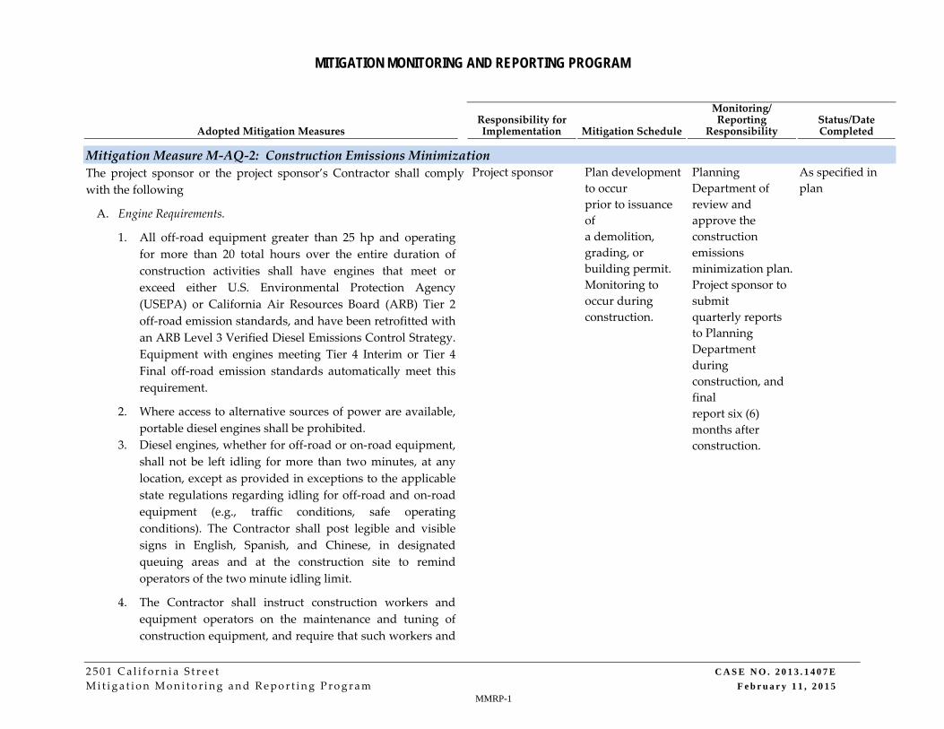
MITIGATION MONITORING AND REPORTING PROGRAM
2501 Cal i f o rn i a S t r e e t C A S E N O . 2 0 1 3 . 1 4 0 7 E
Mit i ga t i on Moni to r ing and Repor t ing Program F e b r u a r y 1 1 , 2 0 1 5 MMRP-1
Adopted Mitigation Measures Responsibility for Implementation Mitigation Schedule
Monitoring/ Reporting
Responsibility Status/Date Completed
Mitigation Measure M‐AQ‐2: Construction Emissions Minimization
The project sponsor or the project sponsor’s Contractor shall comply
with the following
Project sponsor Plan development
to occur
prior to issuance
of
a demolition,
grading, or
building permit.
Monitoring to
occur during
construction.
Planning
Department of
review and
approve the
construction
emissions
minimization plan.
Project sponsor to
submit
quarterly reports
to Planning
Department
during
construction, and
final
report six (6)
months after
construction.
As specified in
plan
A. Engine Requirements.
1. All off‐road equipment greater than 25 hp and operating
for more than 20 total hours over the entire duration of
construction activities shall have engines that meet or
exceed either U.S. Environmental Protection Agency
(USEPA) or California Air Resources Board (ARB) Tier 2
off‐road emission standards, and have been retrofitted with
an ARB Level 3 Verified Diesel Emissions Control Strategy.
Equipment with engines meeting Tier 4 Interim or Tier 4
Final off‐road emission standards automatically meet this
requirement.
2. Where access to alternative sources of power are available,
portable diesel engines shall be prohibited.
3. Diesel engines, whether for off‐road or on‐road equipment,
shall not be left idling for more than two minutes, at any
location, except as provided in exceptions to the applicable
state regulations regarding idling for off‐road and on‐road
equipment (e.g., traffic conditions, safe operating
conditions). The Contractor shall post legible and visible
signs in English, Spanish, and Chinese, in designated
queuing areas and at the construction site to remind
operators of the two minute idling limit.
4. The Contractor shall instruct construction workers and
equipment operators on the maintenance and tuning of
construction equipment, and require that such workers and

MITIGATION MONITORING AND REPORTING PROGRAM
2501 Cal i f o rn i a S t r e e t CASE NO. 2013 . 1407E
Mit i ga t i on Moni to r ing and Repor t ing Program Februa ry 11 , 2015 MMRP-2
Adopted Mitigation Measures Responsibility for Implementation Mitigation Schedule
Monitoring/ Reporting
Responsibility Status/Date Completed
operators properly maintain and tune equipment in
accordance with manufacturer specifications.
B. Waivers.
1. The Planning Department’s Environmental Review Officer or
designee (ERO) may waive the alternative source of power
requirement of Subsection (A)(2) if an alternative source of
power is limited or infeasible at the project site. If the ERO
grants the waiver, the Contractor must submit
documentation that the equipment used for onsite power
generation meets the requirements of Subsection (A)(1).
2. The ERO may waive the equipment requirements of
Subsection (A)(1) if: a particular piece of off‐road equipment
with an ARB Level 3 VDECS is technically not feasible; the
equipment would not produce desired emissions reduction
due to expected operating modes; installation of the
equipment would create a safety hazard or impaired
visibility for the operator; or, there is a compelling
emergency need to use off‐road equipment that is not
retrofitted with an ARB Level 3 VDECS. If the ERO grants
the waiver, the Contractor must use the next cleanest piece
of off‐road equipment, according to Table below.
This space intentionally left blank.

MITIGATION MONITORING AND REPORTING PROGRAM
2501 Cal i f o rn i a S t r e e t CASE NO. 2013 . 1407E
Mit i ga t i on Moni to r ing and Repor t ing Program Februa ry 11 , 2015 MMRP-3
Adopted Mitigation Measures Responsibility for Implementation Mitigation Schedule
Monitoring/ Reporting
Responsibility Status/Date Completed
Table – Off‐Road Equipment Compliance Step‐
down Schedule
Complianc
e
Alternative
Engine
Emission
Standard
Emissions
Control
1 Tier 2 ARB Level 2
VDECS
2 Tier 2 ARB Level 1
VDECS
3 Tier 2 Alternative
Fuel*
How to use the table: If the ERO
determines that the equipment
requirements cannot be met, then the
project sponsor would need to meet
Compliance Alternative 1. If the ERO
determines that the Contractor cannot
supply off‐road equipment meeting
Compliance Alternative 1, then the
Contractor must meet Compliance
Alternative 2. If the ERO determines that
the Contractor cannot supply off‐road
equipment meeting Compliance
Alternative 2, then the Contractor must
meet Compliance Alternative 3.
** Alternative fuels are not a VDECS.
C. Construction Emissions Minimization Plan. Before starting on‐

MITIGATION MONITORING AND REPORTING PROGRAM
2501 Cal i f o rn i a S t r e e t CASE NO. 2013 . 1407E
Mit i ga t i on Moni to r ing and Repor t ing Program Februa ry 11 , 2015 MMRP-4
Adopted Mitigation Measures Responsibility for Implementation Mitigation Schedule
Monitoring/ Reporting
Responsibility Status/Date Completed
site construction activities, the Contractor shall submit a
Construction Emissions Minimization Plan (Plan) to the
ERO for review and approval. The Plan shall state, in
reasonable detail, how the Contractor will meet the
requirements of Section A.
3. The Plan shall include estimates of the construction timeline
by phase, with a description of each piece of off‐road
equipment required for every construction phase. The
description may include, but is not limited to: equipment
type, equipment manufacturer, equipment identification
number, engine model year, engine certification (Tier rating),
horsepower, engine serial number, and expected fuel usage
and hours of operation. For VDECS installed, the description
may include: technology type, serial number, make, model,
manufacturer, ARB verification number level, and installation
date and hour meter reading on installation date. For off‐road
equipment using alternative fuels, the description shall also
specify the type of alternative fuel being used.
4. The ERO shall ensure that all applicable requirements of the
Plan have been incorporated into the contract specifications.
The Plan shall include a certification statement that the
Contractor agrees to comply fully with the Plan.
5. The Contractor shall make the Plan available to the public for
review on‐site during working hours. The Contractor shall
post at the construction site a legible and visible sign
summarizing the Plan. The sign shall also state that the public
may ask to inspect the Plan for the project at any time during
working hours and shall explain how to request to inspect the
Plan. The Contractor shall post at least one copy of the sign
in a visible location on each side of the construction site
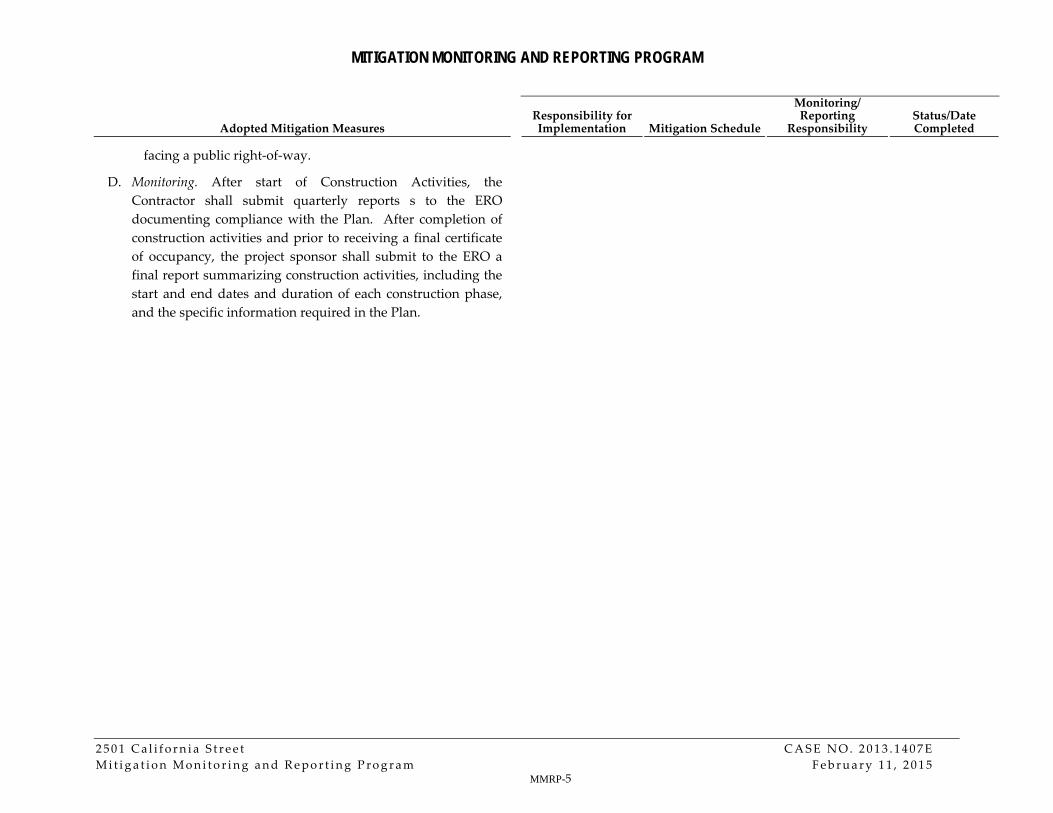
MITIGATION MONITORING AND REPORTING PROGRAM
2501 Cal i f o rn i a S t r e e t CASE NO. 2013 . 1407E
Mit i ga t i on Moni to r ing and Repor t ing Program Februa ry 11 , 2015 MMRP-5
Adopted Mitigation Measures Responsibility for Implementation Mitigation Schedule
Monitoring/ Reporting
Responsibility Status/Date Completed
facing a public right‐of‐way.
D. Monitoring. After start of Construction Activities, the
Contractor shall submit quarterly reports s to the ERO
documenting compliance with the Plan. After completion of
construction activities and prior to receiving a final certificate
of occupancy, the project sponsor shall submit to the ERO a
final report summarizing construction activities, including the
start and end dates and duration of each construction phase,
and the specific information required in the Plan.