MITIGATED NEGATIVE DECLARATION - City of Salinas · The Initial Study and this mitigated negative...
124
MITIGATED NEGATIVE DECLARATION AND INITIAL STUDY T HE G ATEWAY C ENTER S PECIFIC P LAN PREPARED FOR City of Salinas Community and Economic Development Department July 26, 2011
Transcript of MITIGATED NEGATIVE DECLARATION - City of Salinas · The Initial Study and this mitigated negative...

MITIGATED NEGATIVE DECLARATION AND INITIAL STUDY
THE GATEWAY CENTER SPECIFIC PLAN
PREPARED FOR
City of Salinas Community and Economic Development Department
July 26, 2011

This document was produced on recycled paper.
THE GATEWAY CENTER SPECIFIC PLAN
Mitigated Negative Declaration and Initial Study
PREPARED FOR City of Salinas Community and Economic Development Department
Tara Hullinger, Principal Planner 65 West Alisal Street Salinas, CA 93901 Tel 831.758.7206
PREPARED BY EMC Planning Group Inc.
301 Lighthouse Avenue, Suite C Monterey, CA 93940
Tel 831.649.1799 Fax 831.649.8399
[email protected] www.emcplanning.com
July 26, 2011

CITY OF SALINAS Community and Economic Development Department
65 West Alisal Street, Salinas, CA 93901
MITIGATED NEGATIVE DECLARATION
The project described below has been reviewed in accordance with the Environmental Quality Act (CEQA) and has been determined to have an insignificant effect upon the environment. Project’s Common Name: The Gateway Center Specific Plan Lead Agency Name and Address: City of Salinas 65 W. Alisal Street Salinas, CA 93901 Contact Person and Phone Number: Tara Hullinger Principal Planner Community and Economic Development Department City of Salinas 65 West Alisal Street (Second Floor) Salinas, CA 93901 File No.(s): SPEC 2010-001, RZ 2010-002 and related Development Review Applications (see below) . Project Applicant: Cloverfield Management, LLC Project Location: The 20.23 acre project site is located at the northwest corner of the San Juan Grade Road/East Boronda Road intersection in the northern portion of the City. It is located within a portion of the City’s Future Growth Area, located north of East Boronda Road. The Future Growth Area is where the vast majority of the City’s future urban growth will be directed in accordance with the Salinas General Plan. This portion of the Future Growth Area (consisting of approximately 2,500 acres) was annexed to the City on September 8, 2008. The proposed project is the first development proposal to be considered for approval by the City within this area.

The Gateway Center Specific Plan MND Page 2
Project Description: The proposed project is a commercial retail shopping center on approximately 17.49 acres and a stormwater detention/retention basin on approximately 2.74 acres. A total of about 207,500 square feet of commercial retail uses are planned. A building of about 121,000 square feet with an accompanying 31,500 square-foot garden center will serve an anchor tenant, which is anticipated to be a Lowe’s home improvement store. Five additional retail/services outbuildings with a total of 55,000 square feet of floor area are planned. The outbuildings range in size from about 3,500 to 15,000 square feet. The maximum square footage of gross floor area of buildings allowed at the site will be 207,500 square feet. The applicant would also construct an on-site stormwater detention/retention basin easement that is contiguous to the shopping center. The basin will have the capability to be expanded in the future by developers of vacant properties that abut the project site. The Salinas General Plan requires that a specific plan be prepared prior to development in the City’s future growth areas. Consistent with this requirement, the applicant has prepared “The Gateway Center Specific Plan”. A copy of the Draft Specific Plan document and a range of technical studies prepared in association with the proposed project can be found on the CD located on the inside back cover of this document. The Draft Specific Plan includes an introduction, land use and development regulations, design standards, architectural standards, circulation system plan, infrastructure plan, community services and facilities plan, and an implementation program. The Specific Plan, once adopted, serves as both a planning and regulatory function and implements the General Plan for the project site. Rezoning of the site from New Urbanism Interim (NI) with a Specific Plan Overlay (a holding zone designation for the Future Growth Area) to Commercial Retail (CR) with a Specific Plan Overlay for the shopping center portion and to Open Space (OS) with a Specific Plan Overlay for the detention/retention basin portion is required. The site will be subdivided to consist of one parcel with an on-site easement for the detention/retention basin. A development agreement and parcel map development review applications are also proposed. The potential environmental impacts of developing the Future Growth Area, including the project site, with uses identified in the General Plan were evaluated in two prior program environmental impact reports (EIR). The first was the 2002 City of Salinas General Plan Final EIR (GP EIR). The second was the 2007 Supplement for the Salinas General Plan Final Program EIR (SEIR). The SEIR examined potential impacts of developing only the FGA. It supplemented the prior GP EIR analysis based on new information that had become available since 2002 when the GP EIR was certified.

The Gateway Center Specific Plan MND Page 3
Where appropriate, the analysis of environmental effects of the proposed project included in the Initial Study references section 15183 of the CEQA Guidelines, which addresses projects that are consistent with a community plan or zoning. CEQA mandates that projects which are consistent with the development density established by existing zoning, community plan, or general plan policies for which an EIR was certified shall not require additional environmental review, except as might be necessary to examine whether there are project-specific significant effects which are peculiar to the project or its site. In this context, the prior program EIRs were utilized as reference to address potential environmental impacts that are not peculiar to the project or its site. The Initial Study and this mitigated negative declaration will also serve as the environmental documentation to amend the City’s Traffic Fee Ordinance to include the N. Main Street/E. Boronda Road intersection as an improvement. The City anticipates modifying its Traffic Fee Ordinance, concurrent with the approval of the Specific Plan and related documents, to include this improvement to mitigate off-site traffic-related impacts related to the development. Determination: The attached Initial Study has been prepared for the proposed project in accordance with the California Environmental Quality Act and procedures established in the CEQA Guidelines. On the basis of the Initial Study, the City of Salinas makes the following determination:
I find that the above project will not have a significant effect on the environment, and a NEGATIVE DECLARATION is hereby approved.
I find that the above project could have a significant effect on the environment, but WILL
NOT have a significant effect in this case because the attached mitigation measures have been made by or agreed to by the applicant which will avoid the effects or mitigate the effects to a point where clearly no significant effects will occur. Furthermore, there is no substantial evidence before the City of Salinas that the proposed project, as revised, may have a significant effect on the environment. A (MITIGATED) NEGATIVE DECLARATION is hereby approved.
Mitigation measures included in the project to avoid potentially significant effects are identified in the attached Mitigation Monitoring and Reporting Program.
I find that the proposed project MAY have a significant effect on the environment, and an
ENVIRONMENTAL IMPACT REPORT is required.

THE GATEWAY CENTER SPECIFIC PLAN MITIGATION MONITORING AND REPORTING PROGRAM
INTRODUCTION
CEQA Guidelines section 15097 requires public agencies to adopt reporting or monitoring programs when they approve projects subject to an environmental impact report or a negative declaration that includes mitigation measures to avoid significant adverse environmental effects. The reporting or monitoring program is to be designed to ensure compliance with conditions of project approval during project implementation in order to avoid significant adverse environmental effects.
The law was passed in response to historic non-implementation of mitigation measures presented in environmental documents and subsequently adopted as conditions of project approval. In addition, monitoring ensures that mitigation measures are implemented and thereby provides a mechanism to evaluate the effectiveness of the mitigation measures.
A definitive set of project conditions would include enough detailed information and enforcement procedures to ensure the measure's compliance. This monitoring program is designed to provide a mechanism to ensure that mitigation measures and subsequent conditions of project approval are implemented.
MONITORING PROGRAM
The basis for this monitoring program is the mitigation measures included in the project mitigated negative declaration. These mitigation measures are designed to eliminate or reduce significant adverse environmental effects to less than significant levels. These mitigation measures become conditions of project approval, which the project proponent is required to complete during and after implementation of the proposed project.
The attached list is proposed for monitoring the implementation of the mitigation measures. This monitoring checklist contains all appropriate mitigation measures in the mitigated negative declaration.

The Gateway Center Specific Plan MMRP Page 2
MONITORING PROGRAM PROCEDURES
The City of Salinas shall use the attached mitigation monitoring list for the proposed project. The monitoring program should be implemented as follows:
1. The City of Salinas is responsible for coordinating the monitoring program, including the monitoring list. The City of Salinas is responsible for completing the monitoring list and distributing the list to the responsible individuals or agencies for their use in monitoring the mitigation measures.
2. Each responsible individual or agency will then be responsible for determining whether the mitigation measures contained in the monitoring list have been complied with. Once all mitigation measures have been complied with, the responsible individual or agency should submit a copy of the monitoring list to the City of Salinas to be placed in the project file. If the mitigation measure has not been complied with, the monitoring list should not be returned to the City of Salinas.
3. The City of Salinas will review the list to ensure that appropriate mitigation measures included in the monitoring list have been complied with at the appropriate time. Compliance with mitigation measures is required for project approvals.
4. If a responsible individual or agency determines that a non-compliance event has occurred, a written notice should be delivered by certified mail to the City of Salinas within 10 calendar days, describing the non-compliance and requiring compliance within a specified period of time. If non-compliance still exists at the expiration of the specified period, construction may be halted and fines may be imposed at the discretion of the City of Salinas.

The Gateway Center Specific Plan MMRP Page 3
GATEWAY CENTER SPECIFIC PLAN MITIGATION MONITORING AND REPORTING PROGRAM
In addition to the mitigation measures listed below, the mitigation measures identified in the City’s 2002 General Plan FEIR and the Final Supplement to the General Plan Final Program EIR apply to the project and are incorporated by reference. _________________________________________________________________________
Prior to Issuance of a Grading Permit or During Grading
BIO-1. If the tree located along San Juan Grade Road is removed or ground disturbance activities are initiated during the nesting season for raptors (February 1 through August 31), a qualified biologist shall conduct a pre-construction survey for nesting raptors within 15 calendar days prior to either action. If a survey is required, the biologist will submit a report documenting the results of the survey and plan for avoidance to the City. The applicant will implement the plan for avoidance prior to tree removal or initiation of ground disturbance activities. If the tree is removed and/or ground disturbance activities are conducted outside the non-nesting season (September 1 to January 31), the pre-construction survey is not required.
Party Responsible for Implementation: Applicant
Party Responsible for Monitoring: City of Salinas
Implementation Complete
Monitoring Notes and Status:
HAZ-1. Prior to the issuance of a grading permit, the applicant shall sample for the potential presence of pesticide or herbicide residues in site soils consistent with appropriate testing protocols (i.e. California Department of Toxic Substances Control). If any sample results exceed commonly used regulatory thresholds which are applicable to commercial/retail projects, further testing as needed and/or remediation of site soils may be required. The sampling results shall be submitted to the Salinas Permit Center for review. If remediation is required, a remediation plan shall be prepared by

The Gateway Center Specific Plan MMRP Page 4
the applicant, approved by the Salinas Permit Center, and implemented prior to issuance of a grading permit.
Party Responsible for Implementation: Applicant
Party Responsible for Monitoring: City of Salinas
Implementation Complete
Monitoring Notes and Status:
HAZ-2. Buried concrete pipes that are uncovered during grading and/or excavation activities shall be evaluated to determine if they contain asbestos. The pipes shall not be broken or crushed before the evaluation is conducted. The evaluation shall be subject to review of the Salinas Permit Center. If the evaluation concludes that asbestos is present, a remediation plan shall be prepared by the applicant, approved by the Salinas Permit Center and implemented by the applicant.
Party Responsible for Implementation: Applicant
Party Responsible for Monitoring: City of Salinas
Implementation Complete
Monitoring Notes and Status:
HW-1. To assure the assumed functioning of the stormwater management systems, prior to approval of a grading permit the applicant shall:
a. Demonstrate the validity of the assumed infiltration rate at the bottom elevation of the proposed detention/retention basins to the satisfaction of the Salinas Permit Center pursuant to SWDS methods. If the resulting infiltration rate is lower than what had been assumed, the applicant shall revise the plan to provide the expected performance, with the revised plan also subject to review and approval of the Salinas Permit Center.
b. Obtain approval of the Salinas Permit Center to store stormwater runoff for longer than 96 hours. If approval cannot be obtained, the applicant shall

The Gateway Center Specific Plan MMRP Page 5
revise the plan to provide the expected performance, with the revised plan also subject to review and approval of the Salinas Permit Center.
c. Prepare a plan for vector control at the detention/retention basin if the draw down will be in excess of 72 hours. The plan shall be subject to review and approval of the Salinas Permit Center.
Party Responsible for Implementation: Applicant/City of Salinas
Party Responsible for Monitoring: City of Salinas
Implementation Complete
Monitoring Notes and Status:
_________________________________________________________________________
TRANS-1: A funding source for the Boronda Road/North Main intersection improvements as defined in the Salinas (Cloverfield) Retail Center Transportation Impact Analysis must be identified and in place prior to the City Engineer’s issuance of a grading permit for the proposed project. The funding source may be traffic impact fees collected from the applicant pursuant to modification of the City’s Traffic Fee Ordinance to include the improvement or a reimbursement or other agreement with the applicant requiring the applicant to fund the improvement.
Party Responsible for Implementation: Applicant/City of Salinas
Party Responsible for Monitoring: City of Salinas
Implementation Complete
Monitoring Notes and Status:
_________________________________________________________________________
Prior to Construction
A-1. A ten-foot wide landscaping planter shall be provided along the length of the screen wall to reduce the potential for graffiti defacement and to screens views of the service areas located at the rear of the anchor tenant building. The landscaping planter shall be provided along the north side of the screen wall. If the landscape planter is provided off-site, an easement for the landscaping planter shall be provided prior to issuance of the first building permit at the site. Vines shall be

The Gateway Center Specific Plan MMRP Page 6
provided along the northeast side of the screen wall to reduce potential for graffiti defacement, but no landscape planter shall be required. A landscaping and irrigation plan for the landscape planter and vine plantings shall be subject to the approval of the City Planner in accordance with the landscaping and irrigation requirements of the Specific Plan prior to issuance of the first building permit at the site. The landscaping materials and irrigation shall be installed prior to occupancy of the first building at the site.
Party Responsible for Implementation: Applicant
Party Responsible for Monitoring: City of Salinas
Implementation Complete
Monitoring Notes and Status:
_________________________________________________________________________
N-1. An 80-foot off-site noise attenuation (residential setback) easement shall be provided which includes land located between the northern and northeastern boundaries of the project site and planned future residences to the north and northeast of the project site. The easement is required to ensure that the City’s maximum noise exposure standard of 60 dB CNEL for residential uses as established in Zoning Code Section 37-50.180 is not exceeded due to noise generated by truck delivery and loading dock operations being conducted within the project site. The easement shall be provided by the applicant prior to issuance of the first building permit for the proposed project.
Party Responsible for Implementation: Applicant
Party Responsible for Monitoring: City of Salinas
Implementation Complete
Monitoring Notes and Status:
During Construction
CR-1. In the event that significant paleontological and/or archaeological remains are uncovered during excavation and/or grading, all work shall stop in the area of the subject property until an appropriate data recovery program can be developed and implemented by a qualified archaeologist.

The Gateway Center Specific Plan MMRP Page 7
Party Responsible for Implementation: Applicant
Party Responsible for Monitoring: City of Salinas
Implementation Complete
Monitoring Notes and Status:
CR-2. If human remains are found during construction within the project site, there shall be no further excavation or disturbance of the site or any nearby area reasonably suspected to overlie adjacent human remains until an archeological monitor and the coroner of Monterey County are contacted. If it is determined that the remains are Native American, the coroner shall contact the Native American Heritage Commission within 24 hours. The Native American Heritage Commission shall identify the person or persons it believes to be the most likely descendent (MLD) from the deceased Native American. The MLD may then make recommendations to the landowner or the person responsible for the excavation work, for means of treating or disposing of, with appropriate dignity, the human remains and associated grave goods as provided in Public Resources Code section 5097.98. The landowner or his authorized representative shall rebury the Native American human remains and associated grave goods with appropriate dignity on the property in a location not subject to further disturbance if: a) the Native American Heritage Commission is unable to identify a MLD or the MLD failed to make a recommendation within 24 hours after being notified by the commission; b) the descendent identified fails to make a recommendation; or c) the landowner or his authorized representative rejects the recommendation of the descendent, and the mediation by the Native American Heritage Commission fails to provide measures acceptable to the landowner.
Party Responsible for Implementation: Applicant
Party Responsible for Monitoring: City of Salinas
Implementation Complete
Monitoring Notes and Status:
_________________________________________________________________________

The Gateway Center Specific Plan MMRP Page 8
During Operations
N-2. Loading dock activities shall be limited to 7:00 am to 9:00 pm daily in conformance with City Zoning Regulations except that the anchor tenant may be permitted one nighttime delivery with related loading dock operations on an interim basis until issuance of the first building permit for future residential development to the north and northeast of the project site. The exception shall cease at that time unless a noise study is prepared as part of the future CEQA review process for adjacent future residential development which demonstrates to the satisfaction of the City Planner that maximum exposure noise levels at future adjacent residential uses will not exceed 60 dB CNEL (assuming that the delivery/loading dock exception will remain in place). Upon request, the applicant shall provide shipping and receiving documentation for review by the City Planner for conformance with the interim delivery/loading dock operations exception.
Party Responsible for Implementation: Applicant
Party Responsible for Monitoring: City of Salinas
Implementation Complete
Monitoring Notes and Status:
_________________________________________________________________________
N-3. Amplified sound shall not be allowed at any time during nighttime loading operations being conducted under the interim nighttime delivery/loading dock operations.
Party Responsible for Implementation: Applicant
Party Responsible for Monitoring: City of Salinas
Implementation Complete
Monitoring Notes and Status:
_________________________________________________________________________
N-4. All delivery trucks with diesel powered engines entering the site during nighttime hours shall use the most easterly driveway located off East Boronda Road for ingress to and egress from the site. These trucks shall queue along the east property line (along the detention/retention basin). Trucks with idling engines shall not queue/park within 100 feet of the common property lines between the site and the future residential uses to the north and northeast. This requirement shall be

The Gateway Center Specific Plan MMRP Page 9
included in all vendor contract documents and the applicant shall post signage at appropriate locations throughout the project site informing vendors of this requirement. Signage shall be installed prior to issuance of an occupancy permit for any building.
Party Responsible for Implementation: Applicant
Party Responsible for Monitoring: City of Salinas
Implementation Complete
Monitoring Notes and Status:
_________________________________________________________________________

The Gateway Center Specific Plan MMRP Page 10
This side intentionally left blank.


GATEWAY CENTER SPECIFIC PLAN INITIAL STUDY TABLE OF CONTENTS
Project Description...........................................................................................................1 General Plan and Land Use...........................................................................................14 Initial Study Methodology...............................................................................................23 Environmental Factors Potentially Affected ...................................................................24 Checklist ........................................................................................................................25
1. Aesthetics........................................................................................................25 2. Agricultural Resources ....................................................................................29 3. Air Quality........................................................................................................32 4. Biological Resources.......................................................................................38 5. Cultural Resources..........................................................................................41 6. Geology/Soils ..................................................................................................44 7. Greenhouse Gas Emissions............................................................................48 8. Hazards & Hazardous Materials......................................................................51 9. Hydrology and Water Quality ..........................................................................55 10. Land Use and Planning...................................................................................64 11. Energy and Mineral Resources .......................................................................66 12. Noise...............................................................................................................67 13. Population and Housing ..................................................................................74 14. Public Services................................................................................................76 15. Recreation.......................................................................................................78 16. Transportation and Circulation ........................................................................79 17. Utilities and Service Systems..........................................................................86 18. Urban Decay ...................................................................................................92
Mandatory Findings of Significance ...............................................................................97 Source List .....................................................................................................................99 Determination ..............................................................................................................102
List of Tables Table 1 Specific Plan Development Program........................................................13 Table 2 Operational GHG Emissions Inventory.....................................................50 List of Figures Figure 1 Regional Location.......................................................................................3 Figure 2 Project Vicinity ............................................................................................5 Figure 3 Aerial Photograph.......................................................................................7 Figure 4 Project Site Photographs............................................................................9 Figure 5 Specific Plan Map.....................................................................................11 Figure 6 Vehicular Access and Internal Circulation ................................................15 Figure 7 Conceptual Landscape Plan.....................................................................17 Figure 8 Representative Anchor Building Elevation................................................19 Figure 9 Representative Retail/Service Building Elevation.....................................21

MND and Initial Study The Gateway Center Specific Plan Page 2 Appendices Appendix A URBEMIS Report Appendix B Preliminary Geotechnical Evaluation Appendix C Greenhouse Gas Analysis Report Appendix D Phase I Environmental Assessment Appendix E Stormwater Report and Stormwater Environmental Review Memo Appendix F Noise Assessment Appendix G Traffic Impact Analysis Letter from Fehr and Peers
DRAFT INITIAL STUDY City of Salinas
Community and Economic Development Department 65 West Alisal Street
Salinas, California 93901 (831) 758-7206 (831) 758-7215 fax
1. BACKGROUND Project Name: The Gateway Center Specific Plan Project Location: City of Salinas at the northeastern corner of the East Boronda
Road/San Juan Grade Road intersection Assessor Parcel Number(s): 211-231-060 and 211-231-061 Current Land Uses: Agriculture. Surrounding Land Uses/Zoning District: North: Residential and Agriculture
Zoning: Residential Low Density and Residential Medium Density, and New Urbanism Interim
South: Commercial and Residential Zoning: Commercial Retail, Residential High, Residential Medium Density and Residential Low Density
East: Agriculture Zoning: New Urbanism Interim West: Residential Zoning: Residential Medium Density Lead Agency Contact Person: Tara Hullinger, Principal Planner, City of Salinas, 831-
758-7206, [email protected]
Project Description: The project applicant, Cloverfield Management LLC, is seeking approval of a specific plan, a rezoning of the site from New Urbanism Interim (NU) with a Specific Plan Overlay to Commercial Retail (CR) and Open Space (OS) with a Specific Plan Overlay, a parcel map and a development agreement to construct a retail commercial center and an on-site stormwater detention/retention basin on an approximately 20.23-acre site. The project also includes an amendment to the City’s Traffic Fee Ordinance to include the N. Main Street/E. Boronda Road intersection as an improvement. The City anticipates modifying its Traffic Fee Ordinance, concurrent with the approval of the Specific Plan and related documents, to include this improvement to mitigate off-site traffic-related impacts related to the development. Pursuant to the City of Salinas General Plan (General Plan) adopted in 2002, the applicant is required to prepare a specific plan to guide future development of the site. Consistent with this requirement, the applicant has prepared The Gateway Center Specific Plan (hereinafter “Specific Plan”), which is a draft dated May 2011.

MND and Initial Study The Gateway Center Specific Plan Page 2 The Specific Plan includes land use and development regulations and design standards, circulation and infrastructure plans, implementation requirements as well as other information. Much of the information contained in this project description is summarized from the Specific Plan. The Specific Plan can be found on the CD on the inside back cover of this Initial Study document. Please refer to the Specific Plan for more detailed information on the project description. The CD also contains technical reports that have been prepared by the applicant and by consultants to the City. These reports are referenced throughout this Initial Study. The commercial center portion of the project, which would be rezoned to Commercial Retail (CR) with a Specific Plan Overlay, is approximately 17.49 acres of the total site area of 20.23 acres. The remaining 2.74 acres would be rezoned to Open Space (OS) with a Specific Plan Overlay, dedicated as an on-site easement to the City, and utilized to construct a detention/retention basin to accommodate stormwater from the project site. The facility would likely be expanded in the future by other developers to serve future development of surrounding vacant land. The regional location of the project site is shown in Figure 1. Figure 2 depicts existing conditions in the vicinity. Figure 3 is an aerial photograph that shows existing conditions. Figure 4 includes photographs of the project site and adjacent lands to provide more perspective on existing conditions. Please refer to Figure 5, Specific Plan Map, for an illustration of the proposed site layout. A total of approximately 207,500 square feet of building square footage is planned. The major anchor building (A1) is approximately 121,000 square feet and would include an outdoor garden center of approximately 31,500 square feet. The proposed anchor tenant is a Lowe’s home improvement center, but other similar type of tenants could be considered. This anchor tenant will serve as the primary retailer for the shopping center with the intent of drawing local and regional customers. Five smaller “retail/services” buildings ranging in size from approximately 3,500 to 15,000 square feet each are also planned and would total approximately 55,000 square feet. Two of the buildings, one along San Juan Grade Road and one along East Boronda Road, are proposed to accommodate drive-thru services and could be used for fast-food and pharmacy use, respectively. Table 1, Specific Plan Development Program, summarizes the types and sizes of proposed structures and their use. The total floor to area ratio for the portion of the site proposed for commercial development site is .2724. Please see Section 2, Land Use and Development Regulations, of the Specific Plan for more information on land uses.

152
156
Salinas
MorganHill
Hollister
680880
280
152
1
101
156
25
Big Sur
156
85
85
101
Modesto
M
Oakland
99
99
17
5
San LuisReservoir
P a c i f i c O c e a n
ProjectLocationMonterey
Carmel
Santa Cruz
San Francisco
Gilroy
5
Los Banos
580
5
101
152
80
183
59
152
108
4
12
LodiVallejo 80
780
1
1
1
1
Atascadero
Greenfield
Soledad
CoalinKing City
Waterford
Oakdale
Hughson
Tracy
Lathrop
Patterson
Escalon
Gustine
Livingston
165
33
132
88Galt
Ang
4
160
PaloAlto San Jose
Ceres
Turlock
Newman
Stockton
68
Figure 1
Gateway Specific Plan Initial Study
Regional Location
Not to Scale

MND and Initial Study The Gateway Center Specific Plan Page 4
This side intentionally left blank.

E Boronda Rd
San
Juan
Gra
de R
d
US Highway 101
City ofSalinas
Nativid
ad Rd
ProjectLocation
Source: Google Earth 2009
Figure 2
Gateway Specific Plan Initial Study
Project Vicinity
4,000 feet

MND and Initial Study The Gateway Center Specific Plan Page 6
This side intentionally left blank.

Source: Google Earth 2009
Figure 3
Gateway Specifie Plan Initial Study
Aerial Photograph
450 feet
ApproximateProject
Boundaries
E Boronda Rd
San Ju
an Grade Rd
Dar
tmou
th W
ay

MND and Initial Study The Gateway Center Specific Plan Page 8
This side intentionally left blank.

1. View looking north across the site from a point located near Entrance #2 along East Boronda Rd. as shown on the Specific Plan Map (see Figure 5). The San Juan Grade Rd. /East Boronda Rd. intersection is at left.
2. View looking west and south across the site from a point along San Juan Grade Rd. located between Entrances #3 and #4 on San Juan Grade Rd. as shown on the Specific Plan Map (see Figure 5). The San Juan Grade Rd./East Boronda Rd. intersection is at right.
Figure 4
Gateway Specific Plan Initial Study
Site Photos

MND and Initial Study The Gateway Center Specific Plan Page 10
This side intentionally left blank.


MND and Initial Study The Gateway Center Specific Plan Page 12
This side intentionally left blank.

MND and Initial Study The Gateway Center Specific Plan Page 13
Table 1 Specific Plan Development Program Land Use Approximate Land
Area (acres) Building Area (square feet)
Shopping Center Area 1 11.85 A1 121,000 Garden Center for A1 31,500 Subtotal 152,500 Shopping Center Area 2 5.64 55,000 Total Maximum – Areas 1-2 17.49 207,500 Detention/Retention Basin On-site Easement
2.74
Total 20.23 A range of circulation improvements are planned. Figure 6 shows the proposed Vehicular Access and Internal Circulation Plan as illustrated in the Specific Plan. Please refer to Section 4, Circulation, of the Specific Plan for more information. A signalized intersection would be created on San Juan Grade Road at Northridge Way and the existing signalized intersection on East Boronda Road at Dartmouth Way would be improved. Two right-in/right-out only entrances to the site are also planned. A fifth entrance is planned primarily for use by service vehicles. An integrated on-site vehicle and pedestrian circulation system is proposed consisting of marked walkways and internal private drives as well as a six-foot wide public trail along the eastern boundary of the project site. Transit stops are planned on both San Juan Grade Road and East Boronda Road along the project frontages. Bicycle lanes would be striped along the project frontages with each of these roads along with frontage improvements that ensure safe ingress and egress from the project site. A parking field with landscaping planters is provided. The number of parking spaces provided will be based on the parking requirement of one parking space per 292 square feet of gross floor area. The proposed project includes landscape, site design, lighting, signage and furnishings features. These are described in Section 3, Design Standards, of the Specific Plan along with architectural themes and building elevations. Figure 7 is the Conceptual Landscape Plan. It illustrates representative landscaping plantings, pavement treatments, Low Impact Development features such as bio-swales and planters, landscape screening for the detention/retention basin, and other related features. Figures 8 and 9 show representative elevations of the proposed anchor building and other retail/service outbuildings, respectively. Please refer to the Specific Plan for additional detail on these and other project features. In addition to the Specific Plan, the applicant has prepared several technical studies and analyses to evaluate site conditions and assist with project design. These studies, the Specific Plan, and additional technical studies prepared under contract to the City are referenced in this Initial Study where applicable to assist with the identification of
MND and Initial Study The Gateway Center Specific Plan Page 14 potential environmental effects and mitigation measures. As noted above, all referenced technical studies are included on the CD attached to the inside back cover of this document. EMC Planning Group and/or its sub-consultants conducted peer reviews of the consultant-provided studies and concur with the findings of those studies. General Plan and Land Use: The project site is located within an area of the City that is described in the General Plan as the Future Growth Area (FGA). The entire acreage of the FGA contemplated under the General Plan, is approximately 3,525 acres in size. The site is located within the portion (approximately 2,500 acres) of the FGA annexed to the City in 2008. It represents the area in which the vast majority of the City’s future urban growth would be concentrated. New development within the FGA would be largely guided by New Urbanism development principles and would include commercial retail, mixed-use, residential, public/semipublic, park and open space uses. General Plan Land Use Element Implementation Action LU-4 requires that a specific plan be prepared for all new development within the FGA. This requirement is the basis for the applicant’s preparation of a specific plan. The General Plan Land Use and Circulation Policy Map shows that the project site is designated Residential High Density (15-24 units/net acre). The location of uses within the FGA as shown on the Land Use and Circulation Policy Map is meant to be illustrative. To affirm this fact, on December 14, 2010 the Salinas City Council approved Resolution 19958 that provided clarifying language to the General Plan Land Use and Circulation Map. The purpose was to verify that the location of land uses within the FGA is illustrative, that the ultimate distribution, location and intensity of land uses will be specified in specific plans to be prepared prior to development, and that the total development capacity for the FGA must be in accordance with that identified in the General Plan. Consequently, the Residential High Density designation shown on the Land Use and Circulation Policy Map is illustrative and does not inherently limit development of the site to residential use. Provided that the development capacity for commercial retail uses within the FGA as a whole is equal to or greater than that required for the proposed project and that the proposed project is consistent with the development density (expressed as the floor to area ratio) defined for commercial retail use in the FGA, the proposed project would be consistent with land use and development density assumptions for the FGA as identified in the General Plan. The General Plan provides for more retail development commercial capacity within the FGA than is proposed by the applicant. General Plan Table LU-3 shows that Citywide, the maximum permitted floor to area ratio for commercial retail development is 40 percent. The table also shows that within the FGA, approximately 16 acres (696,960 square feet) of land is designated for commercial land use. At a floor to area ratio of 40 percent, a maximum of approximately 278,784 square feet of commercial retail building space is possible within the FGA. At a total of 207,500 square feet of building square footage, the proposed project is well within the maximum retail commercial development capacity allowed. Further, the floor to area ratio for the commercial portion of the


MND and Initial Study The Gateway Center Specific Plan Page 16
This side intentionally left blank.


MND and Initial Study The Gateway Center Specific Plan Page 18
This side intentionally left blank.


MND and Initial Study The Gateway Center Specific Plan Page 20
This side intentionally left blank.


MND and Initial Study The Gateway Center Specific Plan Page 22
This side intentionally left blank.

MND and Initial Study The Gateway Center Specific Plan Page 23
proposed project is .2724, which is well below the maximum permitted development density (floor to area ratio) of .40 for commercial retail uses. Initial Study Methodology: The potential environmental impacts of developing the FGA, including the project site, with uses identified in the General Plan were evaluated in two prior environmental impact reports (EIR). The first was the 2002 City of Salinas General Plan Final EIR (GP EIR). The second was the 2007 Supplement for the Salinas General Plan Final Program EIR (SEIR). The SEIR examined potential impacts of developing only the FGA. It supplemented the prior GP EIR analysis based on new information that had become available since 2002 when the GP EIR was certified. This Initial Study has been prepared using the “tiering” provisions of CEQA as identified in CEQA Guidelines section 15152, wherein lead agencies are encouraged to use the analysis contained in EIRs for broader projects (i.e., a general plan EIR) as part of the analysis for subsequent specific projects. Section 15152(e) notes that tiering must be limited to situations where a project is consistent with the general plan and zoning, which, given the fact that the proposed project is consistent, enables application of tiering provisions. Where prudent and applicable, analyses contained in one or both of these prior EIRs are referenced in this Initial Study as a basis to avoid redundancy and streamline the analysis process for the proposed project. This Initial Study also makes reference to section 15183 of the CEQA Guidelines, which addresses projects that are consistent with a community plan or zoning. CEQA mandates that projects which are consistent with the development density established by existing zoning, community plan, or general plan policies for which an EIR was certified shall not require additional environmental review, except as might be necessary to examine whether there are project-specific significant effects which are peculiar to the project or its site. If a project is consistent with a community plan or zoning, evaluation of such projects in an initial study is to be limited to effects which are: (i) Peculiar to the project or parcel on which it is located; (ii) Were not analyzed as significant effects in a prior EIR on the zoning action, general
plan, or community plan with which the project is consistent; (iii) Are potentially significant off-site impacts and cumulative impacts which were not
discussed in the previous EIR for the general plan, community plan, or zoning action; or
(iv) Are previously identified significant effects, which as a result of substantial new information not available at the time the EIR was certified, are determined to have a more severe adverse impact than discussed in the prior EIR.
As discussed in the “General Plan and Land Use” section above, the proposed project is consistent with the development intensity for commercial retail use within the FGA as identified in the General Plan. Further, the GP EIR and the SEIR address impacts from implementing the General Plan. Therefore, where appropriate, discussion of impacts of

MND and Initial Study The Gateway Center Specific Plan Page 24 the proposed project in this Initial Study has been limited as mandated in CEQA Guidelines section 15183. Section 15183 is particularly relevant for assessment of the incremental cumulative impacts of the proposed project, especially where cumulative impacts were found to be significant and unavoidable in the prior GP EIR and/or SEIR. The prior GP EIR and SEIR identified a range of significant cumulative impacts, some of which were found to be significant and unavoidable and for which the City approved Statements of Overriding Consideration. Examples of the latter include cumulative impacts on a number of transportation facilities and on global climate change. In these cases, the analysis in this Initial Study concludes that these significant and unavoidable cumulative impacts were already identified in one of the previous EIRs and; therefore, the discussion of the project specific effects can be limited and no new analysis of these issues is required. Information referenced in this Initial Study has been taken largely from the GP EIR and SEIR. Additional information has also been taken from technical reports submitted by the applicant that have been reviewed for adequacy by the City and from technical reports prepared under the direction of the City and the City’s CEQA consultant, include an acoustical analysis, traffic impacts analysis, and greenhouse gas emissions report. Environmental Factors Potentially Affected:
Aesthetics Agricultural Resources Air Quality Biological Resources Cultural Resources Geology/Soils Greenhouse Gas Emissions
Hazards & Hazardous Materials
Hydrology/Water Quality
Land Use/Planning Mineral and Energy Resources
Noise
Population/Housing Public Services Recreation Transportation / Traffic
Urban Decay Utilities/Service
Systems Mandatory Findings of Significance

MND and Initial Study The Gateway Center Specific Plan Page 25
2. CHECKLIST
Impact
Issue
No Impact
Less Than Significant
Impact
Potentially Significant
Unless Mitigation
Incorporated
Potentially Significant
Impact
Source
(Refer to Section 3:
Source List)
1. AESTHETICS. Would the
proposal:
(a) Affect a scenic vista or scenic highway?
(b) Substantially damage
scenic resources, including, but not limited to, trees, rock outcroppings, and historic buildings within a state scenic highway?
(c) Substantially degrade the existing visual character or quality of the site and its surroundings?
(d) Create a new source of substantial light or glare which would adversely affect day or nighttime views in the area?
1,2,3 1,2,3 1,2,3 1,2,3,7
Discussion (a,b) The project site is not within a state designated scenic highway corridor;
therefore, the proposed project would have no impact on a scenic highway. Scenic vistas are address in (c) below. (c) The proposed project will substantially alter the visual character of the site,
changing it from an agricultural character to an urban character. Changes in the visual character of the City resulting from new planned development, including new planned development within the FGA, were evaluated in the GP EIR. Areas within the City or planned to be annexed to the City to which specific design

MND and Initial Study The Gateway Center Specific Plan Page 26
treatment requirements are applied include U.S. Highway 101 gateway areas, areas that are highly visible from U.S. Highway 101, and areas at the urban/agricultural edge of the City. The project is not within a gateway area as defined in the GP EIR (Figure 5.11-1, page 5-12-2) nor is it highly visible from U.S. Highway 101.
Aesthetic impacts of development at an urban/agricultural fringe are identified in
the GP EIR as potentially significant. Related potential impacts of the project would be reduced to a less than significant level through implementation of GP EIR mitigation measures A3, A4, and A5. Mitigation A3 requires that new development meet specific standards for outdoor lighting to minimize generation of glare and sky glow, an effect discussed in subsection 1(d) below. Mitigation measure A4 requires that appropriate landscaping requirements are applied to new development to promote greater visual and functional compatibility. Mitigation measure A5 requires that new development be reviewed for its aesthetics impacts pursuant to CEQA. In this regard standards contained in the City’s Zoning Code (lighting), Design Guidelines (architectural details), and Landscaping Standards are applicable to the proposed project and the proposed project must be consistent with them. Please refer to subsection 1(d) below for discussion regarding impacts from project lighting.
As described in Section 3, Design Standards, in the Specific Plan, detailed design standards for landscaping at the project site boundary, in internal areas of the site, and at the stormwater detention/retention basin (for screening and to create a natural appearing water feature purposes) are provided as is a comprehensive landscape plan (please refer back to Figure 7). Design standards for signage and furnishings are also provided. The City has reviewed the fundamental elements of the design standards and may request further refinement of the landscape plans. The fundamental elements for landscape design and planning relative to the City’s Landscaping Standards appear to be met, with the exception of providing adequate visual screening from adjacent properties as described below. Section 3 also details architectural concepts and themes, and contains architectural standards, elevations of each proposed building, and sections of each building. Please refer back to Figures 8 and 9 for representative elevations of selected buildings. The applicant’s proposed architectural design approach is intended to be compatible with existing development and generally is considered to be consistent with the City’s Design Standards and other design related plans.
A proposed eight-foot high screen wall (provided to screen loading and service
activities located at the rear of the anchor tenant building) is located along the north and northeast boundary of the site. Given the length and height of the wall and the lack of existing or proposed vegetation or other improvements in the area to screen views of the wall and deter graffiti defacement, there is the potential for

MND and Initial Study The Gateway Center Specific Plan Page 27
views of the site to be degraded. As such, mitigation has been included to require the installation of a 10-foot landscaping planter along the north and northeast sides of the screen wall. The provision of trees, bushes and vines in this planter will screen views of the wall and discourage graffiti defacement. Mitigation Measure A-1. A ten-foot wide landscaping planter shall be provided along the length of
the screen wall to reduce the potential for graffiti defacement and to screens views of the service areas located at the rear of the anchor tenant building. The landscaping planter shall be provided along the north side of the screen wall. If the landscape planter is provided off-site, an easement for the landscaping planter shall be provided prior to issuance of the first building permit at the site. Vines shall be provided along the northeast side of the screen wall to reduce potential for graffiti defacement, but no landscape planter shall be required. A landscaping and irrigation plan for the landscape planter and vine plantings shall be subject to the approval of the City Planner in accordance with the landscaping and irrigation requirements of the Specific Plan prior to issuance of the first building permit at the site. The landscaping materials and irrigation shall be installed prior to occupancy of the first building at the site.
While a determination of the potential for substantial “degradation” of the existing
site is subjective, the proposed project has been designed to generally be consistent with design related City guidelines and regulations. With the implementation of mitigation measure A-1 above and applicable City standards, this impact will be reduced to a less than less than significant level.
(d) The proposed project would introduce new potential sources of light and glare
(lighting of parking areas, security lighting, building lighting, etc.). Lighting plans for new development must be consistent with lighting regulations found in several locations in Chapter 37, Zoning, of the Municipal Code. Article III, Base District Regulations, Division 5, Section 37-30.220, Design Standards, provides design standards specifically for commercial development. These standards address lighting for security purposes, minimizing reflective surfaces at the ground level, and avoiding roof treatments that generate glare. Section 37-30.220(o) provides specific lighting design standards. Article V, Supplemental Regulations, includes performance and design standards for uses within all zoning districts. Sections 37-50.180(b) and 37-50.480 include supplemental regulations pertaining to outdoor lighting; limiting glare from glass and roofs; shielding parking lot, security, and loading area lighting to limit its splay to off-site properties; and prohibiting lighting that could interfere with the operation of safe movement of vehicles.

MND and Initial Study The Gateway Center Specific Plan Page 28
A detailed lighting plan has not yet been prepared for the proposed project, but the Specific Plan identifies among other features that parking lot lighting will be a maximum of 25 feet in height, will meet City Lighting standards and shall be oriented downward with cut-off fixtures and that high intensity lighting may only be used in service areas or as otherwise reasonably necessary. As such, the project would be consistent basic regulations in Salinas Zoning Code section 37.50.480 which limits the maximum height and illumination levels of such lighting. A detailed lighting plan must be prepared by the project applicant and must be consistent with the standards contained in the Zoning Code to ensure that lighting does not substantially affect daytime or nighttime views in the area. The plan must be particularly sensitive to avoiding casting glare off-site onto adjacent undeveloped properties as these properties will likely be developed with residential uses in the future. This is especially true for lighting of service areas at the rear of the Lowe’s store. Given the fact that the City’s zoning regulations are in part designed to address adverse effects of lighting and that the project lighting design must be consistent with these regulations, the proposed project would have a less than significant impact from glare and sky glow.

MND and Initial Study The Gateway Center Specific Plan Page 29
Impact
Issue
No Impact
Less Than Significant
Impact
Potentially Significant
Unless Mitigation
Incorporated
Potentially Significant
Impact
Source
(Refer to Section 3:
Source List)
2. AGRICULTURAL
RESOURCES. Would the proposal:
(a) Convert Prime Farmland,
Unique Farmland, or Farmland of Statewide Importance (Farmland), as shown on the maps pursuant to the Farmland Mapping and Monitoring Program of the California Resources Agency, to non-agricultural use?
(b) Conflict with existing
zoning for agricultural use or a Williamson Act contract?
(c) Conflict with existing
zoning for, or cause rezoning of, forest land (as defined in Public Resources Code section 12220(g)), timberland (as defined by Public Resources Code section 4526), or timberland zoned Timberland Production (as defined in Public Resources Code section 51104(g))?
(d) Result in the loss of forest
land or conversion of forest land to non-forest use?
(e) Involve other changes in
the existing environment which, due to their location or nature, could result in conversion of Farmland, to
1,2,3,8 1,2,3 1,3 1,3

MND and Initial Study The Gateway Center Specific Plan Page 30
Impact
Issue
No Impact
Less Than Significant
Impact
Potentially Significant
Unless Mitigation
Incorporated
Potentially Significant
Impact
Source
(Refer to Section 3:
Source List)
non-agricultural use or conversion of forest land to non-forest use?
1,2,3
Discussion (a) The project site is classified as Prime Farmland as shown in Figure 5.9-1,
Important Farmlands in the GP EIR. The GP EIR identified the loss of Important Farmlands, including Prime Farmland as a significant unavoidable impact of implementing the General Plan. The proposed project’s incremental impact on the loss of farmland is, therefore, addressed as part of the GP EIR analysis of this issue.
As described in Section 1.0, Background, under “General Plan and Land Use” the proposed project is consistent with the land use and development density for the FGA as established in the General Plan. Pursuant to CEQA Guidelines section 15183, CEQA requires that projects which are consistent with the development density established by existing zoning, community plan, or general plan policies for which an EIR was certified shall not require additional environmental review, except as might be necessary to examine whether there are project-specific significant effects which are peculiar to the project or its site. The project specific impacts on loss of Important Farmland are not peculiar to the project or its site, having already been identified as noted above. Further, CEQA Guidelines section 15183(c) states, “If an impact is not peculiar to the parcel or to the project, has been addressed as a significant effect in the prior EIR, or can be substantially mitigated by the imposition of uniformly applied development policies or standards, as contemplated by subdivision (e) below, then an additional EIR need not be prepared for the project solely on the basis of that impact.” Consequently, no further evaluation of these impacts is required.
As part of the City’s continued implementation of the General Plan, the City adopted an Agricultural Land Preservation Program in April 2008 that serves as partial mitigation for loss of Important Farmland. The Agricultural Land Preservation Program identifies mitigation for agricultural lands expected to convert to urban uses based on their location. For development to the north and east of Highway 101, including development within the FGA, an agricultural land mitigation fee of $750 per acre is required for conversion of land currently

MND and Initial Study The Gateway Center Specific Plan Page 31
designated Prime Farmland or Farmland of Statewide Importance. The applicant will be required to pay this fee as a condition of project approval.
(b) The project site is not under Williamson Act contract. (c,d) The project site contains no forest resources. (e) Vacant sites within the FGA that are adjacent to the project site have been
designated in the General Plan for urban development. Impacts of such development have been evaluated in the GP EIR. Therefore, development of the project site is not anticipated to create pressure for the conversion of adjacent agricultural land that has not already been acknowledged by the City. Until such time as adjacent vacant agricultural land is developed, the City will require that deed restriction be placed on the project site pursuant to the Section 37-50.220 notifying any purchaser, property owner, or tenants of the adjacent agricultural land owner’s right-to-farm those lands. This will help to reduce potential conflicts with the non-agricultural use of the project site and on-going agricultural operations.

MND and Initial Study The Gateway Center Specific Plan Page 32
Impact
Issue
No Impact
Less Than Significant
Impact
Potentially Significant
Unless Mitigation
Incorporated
Potentially Significant
Impact
Source
(Refer to Section 3:
Source List)
3. AIR QUALITY. Would the
proposal:
(a) Conflict with or obstruct implementation of the applicable air quality plan?
(b) Violate any air quality
standard or contribute substantially to an existing or projected air quality violation?
(c) Result in cumulatively considerable net increase of any criteria pollutant for which the project region is non-attainment under an applicable federal or state ambient air quality standard (including releasing emissions which exceed quantitative thresholds for ozone precursors)?
(d) Expose sensitive receptors to substantial pollutant concentrations?
(e) Create objectionable odors
affecting a substantial number of people?
3,9,11,12 3,9,10,13,14 3,9,10 1,2,3,9,10,15,24 2
Discussion (a) Consistency of commercial, industrial, or institutional projects with the Monterey
Bay Unified Air Pollution Control District’s (MBUAPCD) 2008 Air Quality Management Plan for the Monterey Bay Region (AQMP) is determined by comparing the estimated current population of the jurisdiction in which a project is located with the applicable population forecast in the AQMP, which is provided

MND and Initial Study The Gateway Center Specific Plan Page 33
in five- to ten-year increments If the estimated current population does not exceed the forecast for the end of the five- or ten-year population projection increment within which the proposed project would be constructed, indirect emissions associated with the project are deemed to be consistent with the AQMP.
It is anticipated that the proposed project would built out by 2013. The applicable population forecast increment in the AQMP is the forecast for 2020 (Email Communication with Jean Getchell, Supervising Planner, MBUAPCD, December 9, 2010). The population forecast for the City as reported in Table 1-1 of the AQMP for 2020 is 163,234. The City’s current population is estimated at 151,219 (California Department of Finance, January 1, 2011). Since the current population estimate for the City is lower than the most applicable population forecast as reported in the AQMP, the proposed project is consistent with the AQMP.
(b) The proposed project would generate emissions in the short-term from site
preparation and construction activities, and in the long-term from both direct and indirect operational activities. Each of these sources is discussed below.
Short-Term Construction Emissions
Short-term emissions from build out of the General Plan were evaluated in the GP EIR and found to be significant and unavoidable for three criteria pollutants: carbon monoxide (CO), sulfur oxide (SOx), and inhalable particulate matter (PM10). The GP EIR also states that construction emissions analyzed under the GP EIR are speculative and construction related emissions must be evaluated on a project specific basis.
The GP EIR identifies three mitigation measures whose implementation would reduce construction phase emissions, but not to a less than significant level. Of these, mitigation measure AQ3 is the most relevant to the proposed project. It requires that discretionary development proposals be reviewed for their impacts per CEQA and mitigation measures applied to reduce impacts to a less than significant level. Per the CEQA thresholds, the proposed project would result in a significant impact if it would result in the violation of an air quality standard. The project site is located within the MBUAPCD and is therefore subject to the MBUAPCD’s air quality thresholds and standards. The MBUAPCD CEQA Air Quality Guidelines include thresholds for several criteria pollutants. Ozone (O). Construction projects using typical construction equipment, such as dump trucks and scrapers, which emit precursors of ozone, are accommodated in the emission inventories of state- and federally-required air plans and would not have a significant impact on the attainment and maintenance of ozone

MND and Initial Study The Gateway Center Specific Plan Page 34
Ambient Air Quality Standards (page 5-3). No non-typical construction equipment is anticipated to be used for the construction phase of the proposed project. Therefore, construction-related activities would not have a significant impact on the attainment and maintenance of ozone standards.
Inhalable Particulate Matter (PM10). Construction activities (e.g. excavation, grading, on-site vehicles) that directly generate 82 pounds per day (lbs/day) or more of PM10 would have a significant impact on local air quality. Table 5-2 of the guidelines state that construction activities with minimal earthmoving that disturb less than 8.1 acres per day, or construction activities with earthmoving (e.g. grading, excavation) that disturb less than 2.2 acres per day are assumed to be below the 82 lbs/day threshold of significance. The URBEMIS2007 air quality model utilized to quantify daily projected construction emissions from the project. The results were then compared to MBUAPCD’s construction phase emissions thresholds to determine if construction emissions would exceed the thresholds for any criteria pollutant. The results of the URBEMIS model run are shown in Appendix A, which is included on the CD found on the inside back cover of this document. The proposed project would result in approximately 1.8 tons of PM10 in 2012, which is equivalent to about 10 lbs/day, and .05 tons in 2013, which is equivalent to about one-quarter pound per day. Both volumes are well below the MBUAPCD threshold of 82 lbs/day. The proposed project must comply with the City of Salinas Grading Standards. The Grading Standards includes measures intended to control dust. These include applying water or other dust palliatives, covering small stockpiles, and periodic sweeping. These measures will help to reduce PM10 emissions even though the project impact is less than significant.
Long-Term Operational Emissions
The MBUAPCD Air Quality Guidelines include project-level thresholds of significance for operational impacts by pollutant type. An exceedence of any pollutant threshold would represent a significant impact on local or regional air quality. The following thresholds apply to all indirect and direct emissions. Indirect emissions come from mobile sources that access the project site but generally emit off-site; direct emissions are emitted on-site (e.g., stationary sources or on-site mobile equipment).
Ozone (O). Projects which would emit 137 lbs/day or more of indirect and direct Volatile Organic Compounds (VOC), which are measured as Reactive Organic Compounds (ROG), would have a significant impact on regional air quality by emitting substantial amounts of ozone precursors. Similarly, projects which would emit 137 lbs/day or more of direct and indirect NOx emissions would generate

MND and Initial Study The Gateway Center Specific Plan Page 35
substantial emissions and have a significant impact on regional air quality. The URBEMIS2007 air quality model was run to quantify projected direct and indirect operational VOC (ROG) and NOx emissions from the proposed project. The results of the URBEMIS model run are shown in Appendix A. The proposed project would generate 11.55 tons per year of direct and indirect VOC (ROG), which is equivalent to approximately 63 lbs/day. The proposed project is projected to generate 17.09 tons per year of direct and indirect NOx, which is equivalent to approximately 94 lbs/day. Both emissions volumes are below the MBUAPCD threshold of 137 lbs/day for each pollutant. Sulfur Oxide (SO2). Projects which would directly emit 150 pounds or more per day or oxides, such as SO2, would result in substantial air emissions and would generate substantial emissions and have a significant impact on air quality. The URBEMIS2007 air quality model was run to quantify projected SO2 emissions from the proposed project. The proposed project would not directly emit any SO2 during the operational phase. Although the proposed project is projected to indirectly generate 0.08 tons per year of SO2, which is equivalent to approximately 0.44 lbs/day of SO2, this is still well below the MBUAPCD threshold of 150 or more lbs/day. Air emissions from the proposed project would not exceed any MBUAPCD criteria air pollutant threshold volume during either the construction or operational phases. No significant air quality impacts would result from the proposed project.
(c) The NCCAB is considered a nonattainment area due to exceedences of the
California Ambient Air Quality Standards (CAAQS) for ozone and PM10. The proposed project would not exceed the MBUAPCD thresholds for ozone or PM10 Therefore, the incremental contribution by the proposed project to cumulative air emission impacts in the air basin would be considered to be less than cumulatively substantial.
(d) Children, the elderly, and the chronically or acutely ill are the groups typically
considered to be most sensitive to air emissions. These groups are commonly associated with specific land uses such as residential areas, schools, parks, retirement homes, and hospitals. McKinnon Elementary School is located less than one-quarter mile to the east of the project, and Santa Rita Elementary School is located less than one-quarter mile to the northwest of the site. Existing residential uses are located north/northwest of the project site across San Juan Grade Road and to the south across East Boronda Road. According to the SEIR land use plan (Figure 3-5), Medium Density Residential uses may be planned directly to the northeast of the project site and Low Density Residential may be planned directly to the directly to the east of the project site.

MND and Initial Study The Gateway Center Specific Plan Page 36
The most common source of toxic air contaminants associated with urban development is diesel exhaust. Diesel exhaust is especially common during the grading stage of construction when most heavy equipment is used. If exposure of sensitive receptors to high levels of construction or operation-related diesel emissions were to occur, detailed analysis would be necessary. The Environmental Protection Agency (EPA) regulates diesel engine design and fuel composition at the federal level, and has implemented a series of measures to reduce particulate emissions from off-road diesel equipment. California Air Resources Board’s (CARB’s) Regulation for In-use Off-road Diesel Vehicles establishes a state program to reduce emissions from older construction equipment. The regulation is in effect and will reduce construction equipment emissions over time as defined in the regulation which can be found at: http://www.arb.ca.gov/msprog/ordiesel/faq/overview_fact_sheet_dec_2010 final.pdf. Consequently, given these regulations, the fact that site preparation activities will not be of long duration, or that a substantial number of diesel powered diesel emissions equipment will be needed, the effects of diesel emissions during construction would be less than significant.
During the operational phase of the project, diesel trucks would travel to and from the site daily to deliver goods. It is anticipated that the Lowe’s store would received between three to 14 shipments a week from distribution centers. These shipments would be made by WB-65 diesel semi-trucks. Each week, an additional ten to 20 trucks, such as flatbeds, UPS, and FedEx, would be making trips to the site (Email Communication with Jack Mandel, Lowe’s Senior Site Development Manager, December 14, 2010). The proposed project would generate a far lower volume of diesel truck traffic than typically of concern such as for exposure to diesel emissions along the margins of high volume freeways that carry a significant volume of diesel truck traffic. Further, the project CARB has regulations to limit emission related to diesel-fueled commercial motor vehicles. These regulations restrict the time a vehicle can idle to no greater than five minutes at any location and provide requirements on the use of alternative technologies. These factors would reduce this potential impact to a less than significant level.
Carbon monoxide (CO). Carbon monoxide is a mobile source pollutant of local concern for its potential to create localized impacts on sensitive uses. Localized concentrations of CO are a direct function of vehicle idling time and thus, traffic flow conditions. Carbon monoxide concentrations close to congested roadways or intersections can reach unhealthful levels, affecting local sensitive receptors. The MBUAPCD CEQA Guidelines state that a proposed project may cause or substantially contribute to violation of State or national standards for carbon monoxide if it generates traffic that results in the degradation of operations of an intersection from Level of Service D or better to Level of Service E or F.
MND and Initial Study The Gateway Center Specific Plan Page 37
As discussed in Section 16, Transportation and Circulation, the traffic impact analysis for the proposed project concludes that project traffic would result in the degradation of operations at the Boronda Road/North Main Street intersection from Level of Service D to Level of Service E. A mitigation measure is provided that requires improvements to the intersection to maintain operations at Level of Service D or better. Implementation of the mitigation will assume that the incremental increase in traffic generated by the proposed project will not result in unhealthful levels of carbon monoxide at the subject intersection.
(e) Retail commercial projects are not typically sources of odors. The proposed
project is not anticipated to include uses that generate objectionable odors that affect a substantial number of people.

MND and Initial Study The Gateway Center Specific Plan Page 38
Impact
Issue
No Impact
Less Than Significant
Impact
Potentially Significant
Unless Mitigation
Incorporated
Potentially Significant
Impact
Source
(Refer to Section 3:
Source List)
4. BIOLOGICAL RESOURCES.
Would the proposal result in impacts to:
(a) Have a substantial adverse
effect, either directly or through habitat modifications, on any species identified as a candidate, sensitive, or special status species in local or regional plans, policies, or regulations, or by the California Department of Fish and Game or U.S. Fish and Wildlife Service?
(b) Have a substantial adverse
effect on any riparian habitat or other sensitive natural community identified in local or regional plans, policies, regulations or by the California Department of Fish and Game or US Fish and Wildlife Service?
(c) Have a substantial adverse effect on federally protected wetlands as defined by Section 404 of the Clean Water Act (including, but not limited to, marsh, vernal pool, coastal, etc.) through direct removal, filling, hydrological interruption, or other means?
(d) Interfere substantially with the movement of any native resident or
1,3 1,3 1,3

MND and Initial Study The Gateway Center Specific Plan Page 39
Impact
Issue
No Impact
Less Than Significant
Impact
Potentially Significant
Unless Mitigation
Incorporated
Potentially Significant
Impact
Source
(Refer to Section 3:
Source List)
migratory fish or wildlife species or with established native resident or migratory wildlife corridors, or impede the use of native wildlife nursery sites?
(e) Conflict with any local policies or ordinances protecting biological resources, such as a tree preservation policy or ordinance?
(f) Conflict with the provisions of an adopted Habitat Conservation Plan, Natural Community Conservation Plan, or other approved local, regional, or state habitat conservation plan?
1,3 1,3 1,3
Discussion (a-d) GP EIR Figure 5.7-1, Vegetation Communities, shows that the project site is in
agricultural use and contains no vegetation communities (i.e. wetlands/ponds, riparian woodland, oak woodland, or grassland) for which the GP EIR identifies specific impact mitigation. The project site is currently and has historically been used for agricultural cultivation; disking of soil, use of fertilizers/pesticides, and other manipulation of the property for agricultural production purposes has substantially reduced its potential to contain special-status plan species.
The GP EIR also notes that agricultural lands provide limited habitat for native wildlife. The fact that the project site contains no sensitive habitat substantially reduces its value for use by wildlife, include special-status species. The project site location adjacent to residential and commercial urban development and major roadways, and the absence of nearby valuable wildlife habitat substantially limits its potential use as a wildlife movement corridor.

MND and Initial Study The Gateway Center Specific Plan Page 40
The GP EIR concludes (page 5.7-16) that “Within the Salinas planning area, removal of ruderal areas, intensively used agricultural lands (i.e. row cropped land) or landscape trees are not considered significant impacts to biological resources.” A single mature tree is located along northern boundary of the project site adjacent to San Juan Grade Road. The tree would be removed to construct the proposed project. The tree is not considered to provide quality habitat for nesting raptors. Raptors were not observed during a May 2011 site visit. Nevertheless, if the tree were to be utilized as nesting habitat by raptors, construction and site preparation activities could result in the direct loss of nests, including eggs and young, or the abandonment of an active nest by the adults if conducted during the nesting season. Birds of prey (raptors) are protected in California under provisions of the State Fish and Game Code, Section 3503.5, 1992. Implementation of the following mitigation measure would reduce this potential impact to a less than significant level. Mitigation Measure BIO-1. If the tree located along San Juan Grade Road is removed or ground
disturbance activities are initiated during the nesting season for raptors (February 1 through August 31), a qualified biologist shall conduct a pre-construction survey for nesting raptors within 15 calendar days prior to either action. If a survey is required, the biologist will submit a report documenting the results of the survey and plan for avoidance to the City. The applicant will implement the plan for avoidance prior to tree removal or initiation of ground disturbance activities. If the tree is removed and/or ground disturbance activities are conducted outside the non-nesting season (September 1 to January 31), the pre-construction survey is not required.
(e,f) Because the project site does not contain protected biological resources, its
development would not conflict with any City policies or ordinances that protect such resources. For the same reason, the project site is not included within a habitat conservation plan area.

MND and Initial Study The Gateway Center Specific Plan Page 41
Impact
Issue
No Impact
Less Than Significant
Impact
Potentially Significant
Unless Mitigation
Incorporated
Potentially Significant
Impact
Source
(Refer to Section 3:
Source List)
5. CULTURAL RESOURCES.
Would the proposal:
(a) Cause a substantial adverse change in the significance of a historical resource as defined in §15064.5
(b) Cause a substantial adverse change in the significance of an archaeological resource pursuant to §15064.5?
(c) Directly or indirectly
destroy a unique paleontological resource or site or unique geologic feature?
(d) Disturb any human
remains, including those interred outside of formal cemeteries?
1,2,3 1,3 1,3 1,3
Discussion (a) GP EIR Figure 5.8-1, Historic and Architectural Resources, illustrates the location
of such resources within the City. There are no resources identified within the project site as would be expected given that the project site contains no above-ground structures. No further analysis is required.
(b) The GP EIR (page 5.8-4) notes that in the Salinas Valley, areas with a history of
available water supplies are most likely to contain archaeological sites. Accordingly, it is also noted that the Carr Lake/Natividad Creek corridor is the only area within the City limits that has a potential for high sensitivity or potential to contain archaeological resources. A second area of the City in the northwest portion of the planning area is also considered to have high sensitivity. The proposed project site is not located within an archaeologically sensitive area and

MND and Initial Study The Gateway Center Specific Plan Page 42
shows no evidence of having historically contained a source of available water. In Section 1.2.1, the Specific Plan makes reference to a prior cultural resource reconnaissance conducted for the FGA located north of East Boronda Road, which found did not identify any cultural resources visually present.
GP EIR mitigation measure CR-1 requires that an archaeological resources study be conducted for development proposals located in the Carr Lake/Natividad Creek corridor. Such studies are not required for development proposals in any other portion of the City, including the project site. While it is unlikely that archaeological resources will be uncovered during site preparation or construction activities, implementation of the following mitigation measure will ensure that if resources are uncovered, the resources are appropriately protected and treated.
Mitigation Measure
CR-1. The following language will be included in any permit associated with
earth moving activities for development of the proposed project:
In the event that significant paleontological and/or archaeological remains are uncovered during excavation and/or grading, all work shall stop in the area of the subject property until an appropriate data recovery program can be developed and implemented by a qualified archaeologist.
(c) The project site, as is much of the City, is located on deep, unconsolidated soil
alluvium. The project site contains no exposed marine terraces or other unique geological formations or soil resources that are generally known to have a higher potential for containing unique paleontological resources.
(d) The project site does not display specific physical characteristics that indicate it
may contain unknown/unidentified human remains. While it is considered unlikely that human remains will be uncovered during site preparation or construction activities, implementation of the following measure will ensure that if human remains are uncovered, they will be appropriately protected and treated. Mitigation Measure
CR-2. The following language will be included in any permit associated with
earth moving activities for development of the proposed project:
If human remains are found during construction within the project site, there shall be no further excavation or disturbance of the site or any nearby area reasonably suspected to overlie adjacent human remains until an archeological monitor and the coroner of Monterey County are

MND and Initial Study The Gateway Center Specific Plan Page 43
contacted. If it is determined that the remains are Native American, the coroner shall contact the Native American Heritage Commission within 24 hours. The Native American Heritage Commission shall identify the person or persons it believes to be the most likely descendent (MLD) from the deceased Native American. The MLD may then make recommendations to the landowner or the person responsible for the excavation work, for means of treating or disposing of, with appropriate dignity, the human remains and associated grave goods as provided in Public Resources Code section 5097.98. The landowner or his authorized representative shall rebury the Native American human remains and associated grave goods with appropriate dignity on the property in a location not subject to further disturbance if: a) the Native American Heritage Commission is unable to identify a MLD or the MLD failed to make a recommendation within 24 hours after being notified by the commission; b) the descendent identified fails to make a recommendation; or c) the landowner or his authorized representative rejects the recommendation of the descendent, and the mediation by the Native American Heritage Commission fails to provide measures acceptable to the landowner.

MND and Initial Study The Gateway Center Specific Plan Page 44
Impact
Issue
No Impact
Less Than Significant
Impact
Potentially Significant
Unless Mitigation
Incorporated
Potentially Significant
Impact
Source
(Refer to Section 3:
Source List)
6 GEOLOGY/SOILS. Would the
proposal result in or expose people to potential impacts involving:
(a) Expose people or
structures to potential substantial adverse effects, including the risk of loss, injury, or death involving:
(i) Rupture of a known
earthquake fault, as delineated on the most recent Alquist-Priolo Earthquake Fault Zoning Map issued by the State Geologist for the area or based on other substantial evidence of a known fault? Refer to Division of Mines and Geology Special Publication 42.
(ii) Strong seismic ground shaking?
(iii) Seismic-related ground failure, including liquefaction?
(iv) Landslides?
(b) Result in substantial soil erosion or the loss of topsoil?
1,3,16 1,3,16 1,3,16 1,3,16 1,3,16
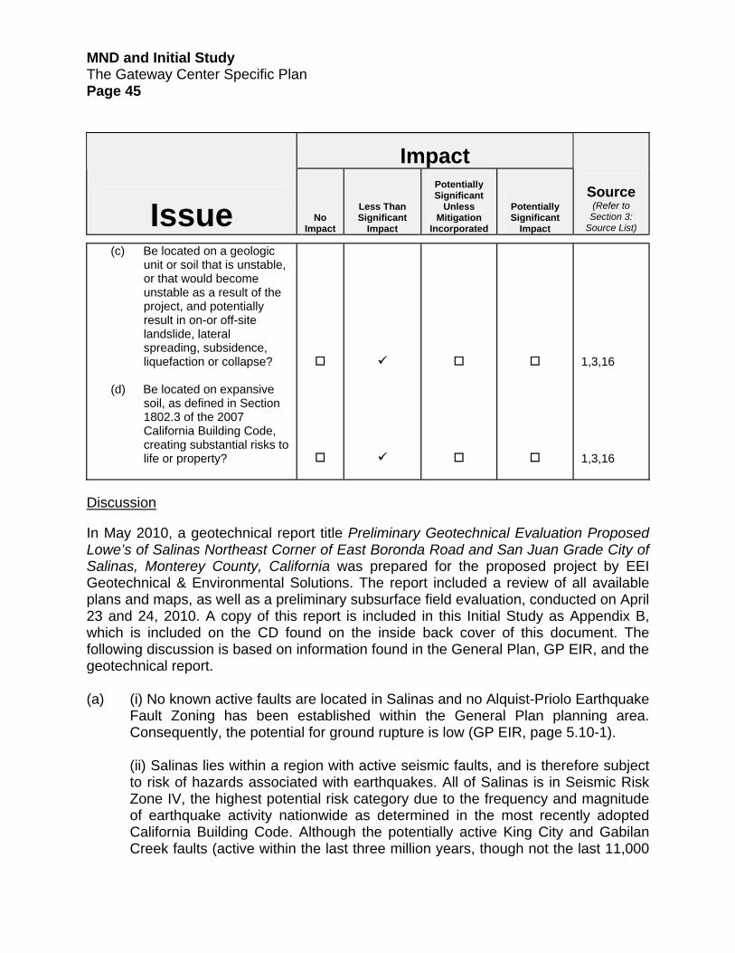
MND and Initial Study The Gateway Center Specific Plan Page 45
Impact
Issue
No Impact
Less Than Significant
Impact
Potentially Significant
Unless Mitigation
Incorporated
Potentially Significant
Impact
Source
(Refer to Section 3:
Source List)
(c) Be located on a geologic unit or soil that is unstable, or that would become unstable as a result of the project, and potentially result in on-or off-site landslide, lateral spreading, subsidence, liquefaction or collapse?
(d) Be located on expansive
soil, as defined in Section 1802.3 of the 2007 California Building Code, creating substantial risks to life or property?
1,3,16 1,3,16
Discussion In May 2010, a geotechnical report title Preliminary Geotechnical Evaluation Proposed Lowe’s of Salinas Northeast Corner of East Boronda Road and San Juan Grade City of Salinas, Monterey County, California was prepared for the proposed project by EEI Geotechnical & Environmental Solutions. The report included a review of all available plans and maps, as well as a preliminary subsurface field evaluation, conducted on April 23 and 24, 2010. A copy of this report is included in this Initial Study as Appendix B, which is included on the CD found on the inside back cover of this document. The following discussion is based on information found in the General Plan, GP EIR, and the geotechnical report. (a) (i) No known active faults are located in Salinas and no Alquist-Priolo Earthquake
Fault Zoning has been established within the General Plan planning area. Consequently, the potential for ground rupture is low (GP EIR, page 5.10-1).
(ii) Salinas lies within a region with active seismic faults, and is therefore subject to risk of hazards associated with earthquakes. All of Salinas is in Seismic Risk Zone IV, the highest potential risk category due to the frequency and magnitude of earthquake activity nationwide as determined in the most recently adopted California Building Code. Although the potentially active King City and Gabilan Creek faults (active within the last three million years, though not the last 11,000

MND and Initial Study The Gateway Center Specific Plan Page 46
years) are located within the planning area, they are not expected to generate seismic activity. The greatest seismic threat is related to the San Andreas and Calaveras faults (GP EIR, page 5.10-1). Figure 5.10-1, Seismic Hazards Zones, in the GP EIR illustrates that based on an evaluation of seismic hazards in the local area the project site is located in a “Low” seismic hazard zone. GP EIR mitigation measure GS1 requires that new development proposals be assessed for potential hazards pursuant CEQA and mitigation measure GS4 requires surveys of soil and geologic conditions where appropriate. Consistent with these mitigations, the applicant submitted a preliminary soils and geology report as discussed above. The report concludes on page 10 that the site is located in a seismically active area and strong ground shaking from earthquakes should be anticipated and the project designed accordingly. GP EIR mitigation measure GS3 requires the City to implement the most recent state building and seismic requirements for the structural design of new development. As a standard condition of approval, the City requires that all new development be constructed consistent with these requirements. (iii) Based on the nature of the subsurface materials and the lack of observed groundwater, EEI finds on page 6 that the project site does not appear to be susceptible to earthquake induced liquefaction or significant amounts of seismic induced ground settlement. GP EIR mitigation measure GS3 requires the City to implement the most recent state building and seismic requirements for the structural design of new development. As a standard condition of approval, the City requires that all new development be constructed consistent with these requirements. (vi) The project site and surrounding properties are essentially flat. There is no potential that seismic shaking could induce landslides within the project site or on adjacent properties.
The proposed project has the potential to expose people or structures to substantial adverse effects due to strong seismic shaking and potential ground failure. This is a potentially significant impact. The project would be designed consistent with California state building requirements for the structural design of new development, including design that accounts for the shrink-swell potential and associated hazards. The geotechnical report includes a recommendations that a supplemental, design-level geotechnical evaluation be performed at the site. The report concludes that the project site is feasible for the proposed project from a geotechnical engineering and geologic viewpoint, provided the recommendations on page 9 of the evaluation are properly implemented. Implementation of these recommendations will be a condition of approval for the
MND and Initial Study The Gateway Center Specific Plan Page 47
proposed project and ensure that related impacts would be reduced to a less than significant level.
(b) The dominant soil on the project site is the Chualar loam (zero to two percent
slopes). The erosion factor for whole soil (Kw), which indicates the susceptibility of a soil to sheet or rill by water, ranges from 0.24 to 0.32. The Kf factor, or the erodibilty of the fine-earth fraction of the soil, is listed at 0.32 to 0.43. Values of K range from 0.02 to 0.69, with the higher the K value, the more susceptible the soil is to sheet or rill erosion by water (EEI page 3). Although the project site is relatively flat, there is potential for some soil loss from erosion.
GP EIR mitigation measure HW1 requires new development to incorporate Best Management Practices pursuant to the National Pollutant Discharge Elimination System (NPDES) permit. Please refer to Section 8, Hydrology and Water Quality, under item (f-g) for further discussion of NPDES requirements. GP EIR mitigation measure AQ1 requires measures to reduce pollutants, including PM10 generated during construction activities, to a less than significant level. Development within the City shall also comply with the City’s Grading Standards, which requires implementation of erosion control measures. Implementation of mitigation measures HWI and AQ1 consistency with the Grading Standards, and implementation of site stormwater management features and actions as described in Section 8, item (f-g) below would reduce the impact to a less than significant level.
(c) Project site soils are characterized as deep alluvial soils. Liquefaction hazards
are described in item (a) above. The project site is essentially level and contains no known or anticipate stability hazards. Off-site hazards from development of the project site are not anticipated, as surrounding properties are also essentially level and soil and geologic conditions are largely uniform. The project would be designed consistent with California state building requirements for the structural design of new development. The implementation of GP EIR mitigation measure GS3 and the implementation of mitigation measure GEO-1 would reduce this impact to a less than significant level.
(d) Shrinkage and bulkage for the site was estimated as part of the geotechnical
evaluation. Ten to 15 percent shrinkage of native soils during earthwork onsite is anticipated as described by EEI on page 14 of the geotechnical report. Damage to the proposed project due to expansive soils is a possibility, but would be minimized; as a standard condition of approval, the City will require that the project be designed and constructed consistent with California state building requirements for the structural design of new development, including design that accounts for the shrink-swell potential and associated hazards. This requirement and the implementation of GP EIR mitigation measure GS3 will assure that this potential impact is less than significant.

MND and Initial Study The Gateway Center Specific Plan Page 48
Impact
Issue
No Impact
Less Than Significant
Impact
Potentially Significant
Unless Mitigation
Incorporated
Potentially Significant
Impact
Source
(Refer to Section 3:
Source List)
7. Greenhouse Gas Emissions.
Would the proposal:
(a) Generate greenhouse gas emission, either directly or indirectly, that may have a significant impact on the environment?
(b) Conflict with an applicable
plan, policy or regulation adopted for the purpose of reducing the emissions of greenhouse gases?
4,17
4,17
Discussion Greenhouse gas (GHG) emissions for the proposed project and their potential to significantly exacerbate climate change impacts were evaluated in a separate report entitled Gateway Greenhouse Gas Analysis Report prepared by EMC Planning Group in 2011. The report is included in Appendix C, which is included on the CD found on the inside back cover of this document. The report includes background, regulatory setting including applicable City efforts to address climate change, and a GHG inventory that quantifies GHG emissions sources and GHG reductions that would accrue from project specific and state measures. Information in this section is summarized from the report. (a,b) Based on preparation of a GHG inventory for the proposed project, under long-
term operational conditions, approximately 8,829 metric tons CO2e (carbon dioxide equivalent) of GHG emissions would be generated on an annual basis. Approximately 88 percent of the total would be from mobile transportation sources, including cars and trucks. Area sources such as on-site combustion of natural gas, and indirect sources, which are emissions generated off-site to produce electricity for the project, comprise much of the remaining 12 percent of the emissions.

MND and Initial Study The Gateway Center Specific Plan Page 49
A range of improvements and measures are proposed for incorporation into the proposed project that would reduce the volume of GHG emissions generated. Representative improvements include provision of transit stops, pedestrian facilities, and bicycle lanes. The project site location in close proximity to a variety of other land uses such as residential and office uses will also be of benefit by reducing vehicle trips and trip lengths needed to access a variety of uses. GHG emission reductions from these sources are estimated at approximately 992 metric tons CO2e per year.
Significant additional GHG reductions will accrue due to regulatory programs being implemented by the state as part of the implementation of California Assembly Bill 32 (AB 32). These programs include the Pavley fuel standards and the Low Carbon Fuel Standards. These programs are designed to increase the fuel efficiency of the California vehicle fleet and to reduce the carbon content of vehicle fuels, respectively. The programs will be a substantial source of reductions because they address the primary source of GHG emissions in the state – transportation. GHG emission reductions from these two regulations are estimated at approximately 2,659 metric tons CO2e per year.
Based on the sources of emissions reductions noted above, GHG emissions reductions totaling approximately 3,666 metric tons CO2e per year would result from the above-noted reduction sources. This figure includes 15 metric tons CO2e per year generated by existing agricultural activities on the project site. Table 2 summarizes the GHG emissions inventory for the proposed project. Further incremental GHG reductions would result from a range of Leadership in Energy and Environmental Design (LEED) measures being proposed by the applicant. Example measures include improving building energy efficiency to exceed 2010 California Title 24 requirements, installing cool roofs which reduce demand for building energy, and reducing interior building and exterior landscaping water demand and the associated energy required for water pumping and treatment.
Potential GHG emissions reductions could also accrue to diverted vehicle trips resulting from the proposed project. Lowe’s closest store is in Gilroy. In 2009, tens of thousands of transactions from customers from the Salinas trade area were recorded at the Gilroy store. It is quite possible that most of the trips to the Gilroy store will be diverted to the Salinas store, thereby substantially reducing the number of vehicle miles traveled for Lowe’s customer trips that originate in the Salinas trade area. Potential GHG reductions from trip diversion were not calculated or included in the GHG inventory for the project as assumptions must be made that could be considered speculative.
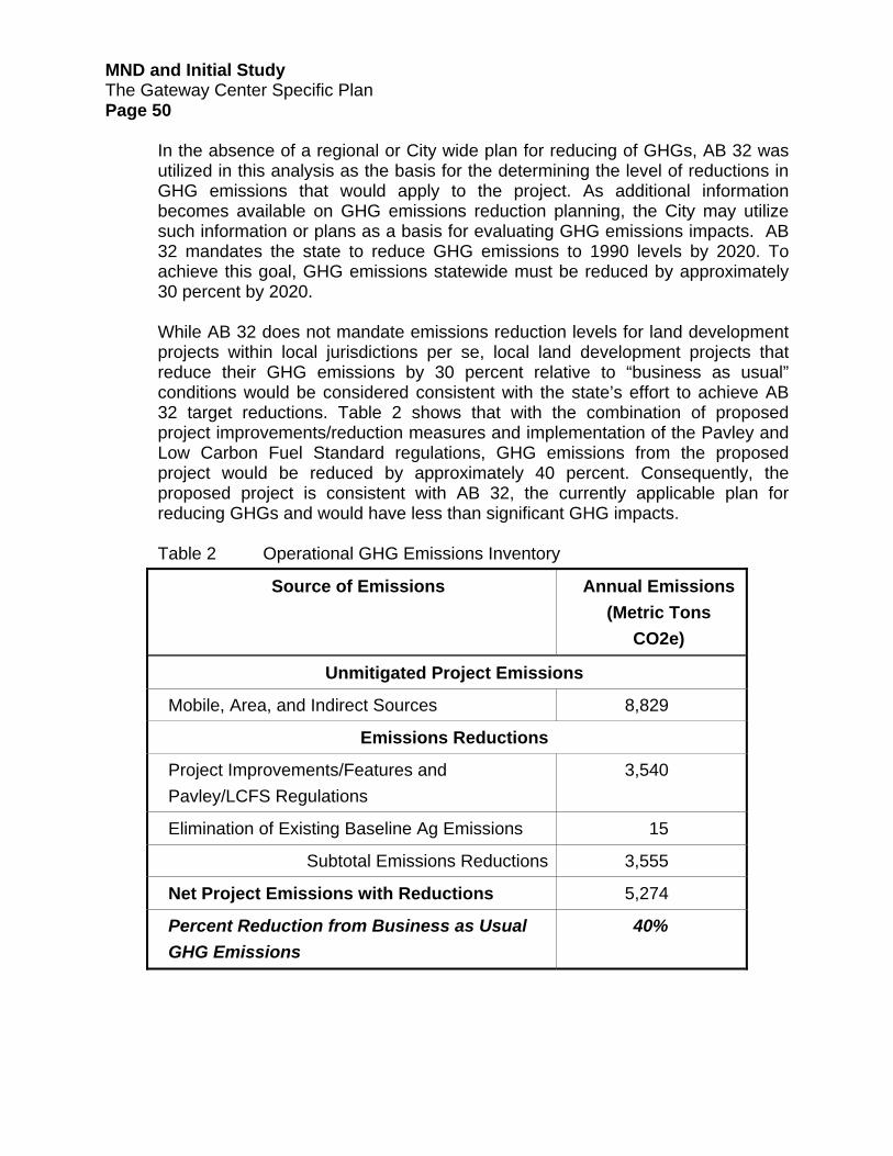
MND and Initial Study The Gateway Center Specific Plan Page 50
In the absence of a regional or City wide plan for reducing of GHGs, AB 32 was utilized in this analysis as the basis for the determining the level of reductions in GHG emissions that would apply to the project. As additional information becomes available on GHG emissions reduction planning, the City may utilize such information or plans as a basis for evaluating GHG emissions impacts. AB 32 mandates the state to reduce GHG emissions to 1990 levels by 2020. To achieve this goal, GHG emissions statewide must be reduced by approximately 30 percent by 2020. While AB 32 does not mandate emissions reduction levels for land development projects within local jurisdictions per se, local land development projects that reduce their GHG emissions by 30 percent relative to “business as usual” conditions would be considered consistent with the state’s effort to achieve AB 32 target reductions. Table 2 shows that with the combination of proposed project improvements/reduction measures and implementation of the Pavley and Low Carbon Fuel Standard regulations, GHG emissions from the proposed project would be reduced by approximately 40 percent. Consequently, the proposed project is consistent with AB 32, the currently applicable plan for reducing GHGs and would have less than significant GHG impacts. Table 2 Operational GHG Emissions Inventory
Source of Emissions Annual Emissions(Metric Tons
CO2e)
Unmitigated Project Emissions
Mobile, Area, and Indirect Sources 8,829
Emissions Reductions
Project Improvements/Features and Pavley/LCFS Regulations
3,540
Elimination of Existing Baseline Ag Emissions 15
Subtotal Emissions Reductions 3,555
Net Project Emissions with Reductions 5,274
Percent Reduction from Business as Usual GHG Emissions
40%

MND and Initial Study The Gateway Center Specific Plan Page 51
Impact
Issue
No
Impact
Less Than Significant
Impact
Potentially Significant
Unless Mitigation
Incorporated
Potentially Significant
Impact
Source
(Refer to Section 3:
Source List)
8. HAZARDS & HAZARDOUS
MATERIALS. Would the proposal involve:
(a) Create a significant hazard
to the public or the environment through the routine transport, use, or disposal of hazardous materials?
(b) Create a significant hazard
to the public or the environment through reasonably foreseeable upset and accident conditions involving the release of hazardous materials into the environment?
(c) Emit hazardous emissions
or handle hazardous or acutely hazardous materials, substances, or waste within one-quarter mile of an existing or proposed school?
(d) Be located on a site which
is included on a list of hazardous materials sites compiled pursuant to Government Code Section 65962.5 and, as a result, would it create a significant hazard to the public or the environment?
(e) For a project within the vicinity of a private airstrip, would the project result in a safety hazard for people
1,2,3,18 1,2,3,18 1,2,3,18 1,2,3,18, 19

MND and Initial Study The Gateway Center Specific Plan Page 52
Impact
Issue
No
Impact
Less Than Significant
Impact
Potentially Significant
Unless Mitigation
Incorporated
Potentially Significant
Impact
Source
(Refer to Section 3:
Source List)
residing or working in the project area?
(f) Impair implementation of or physically interfere with an adopted emergency response plan or emergency evacuation plan?
(g) Expose people or structures to a significant risk of loss, injury or death involving wildland fires, including where wildlands are adjacent to urbanized areas or where residences are intermixed with wildlands?
1,2,3 1,3 1,3
Discussion In April 2010, a report titled Phase 1 Environmental Site Assessment Proposed Lowe’s of Salinas Agricultural Property (“Phase 1 Report”) was prepared for the proposed project by EEI Geotechnical & Environmental Solutions and supplemented with a letter to the City in September 2010. EEI Geotechnical & Environmental Solutions also prepared the Preliminary Geotechnical Evaluation Proposed Lowe’s of Salinas Northeast Corner of East Boronda Road and San Juan Grade City of Salinas, Monterey County, California in May 2010 and supplemented the report with a letter to the City in September 2010. Copies of these materials are included in Appendix D, which is included on the CD found on the inside back cover of this document. The following discussion is based on information in the General Plan, GP EIR, and the two EEI reports and supplemental letters. (a) The proposed Lowe’s store will sell a variety of products that contain hazardous
materials. Those products will require transport to the site. However, the product types sold are in common use and will be transported in a manner that is consistent with federal, state, and local regulations. Consequently, this component of the project should not create hazards that are unique or acute relative to a broad range of other routine retail-oriented sale or transport of such materials. The proposed project would; therefore, not create a significant hazard

MND and Initial Study The Gateway Center Specific Plan Page 53
to the public through the routine transport, use, or disposal of hazardous materials.
(b) The Phase 1 Report concludes that there is no evidence of contamination,
distressed vegetation, petroleum-hydrocarbon staining, waste drums, illegal dumping, or improper waste storage and/or handling at the project site. Although there is no documented use of pesticides and herbicides from the 1940’s through the 1960’s in association with the historical agricultural use of the site, concerns were raised by the City regarding potential presence of these materials and the potential that if present, they could leach into groundwater. In response, EEI recommended that appropriate testing be conducted prior to approval of a final map and appropriate remediation undertaken if concentrations or pesticides or herbicides exceed state regulatory thresholds. Implementation of mitigation measure HAZ-1 below would address this concern and reduce potential impacts to a less than significant level.
The EEI geotechnical reports notes that buried concrete irrigation lines are located on site that would require removal and off-site disposal. It is unknown at this time if these pipes contain asbestos. If they do, demolition and transport of the irrigation lines could create a hazard to worker and public health. Implementation of the mitigation measure HAZ-2 below would reduce this impact to a less than significant level. Mitigation Measures HAZ-1. Prior to the issuance of a grading permit, the applicant shall sample for
the potential presence of pesticide or herbicide residues in site soils consistent with appropriate testing protocols (i.e. California Department of Toxic Substances Control). If any sample results exceed commonly used regulatory thresholds which are applicable to commercial/retail projects, further testing as needed and/or remediation of site soils may be required. The sampling results shall be submitted to the Salinas Permit Center for review. If remediation is required, a remediation plan shall be prepared by the applicant, approved by the Salinas Permit Center, and implemented prior to issuance of a grading permit.
HAZ-2. Buried concrete pipes that are uncovered during grading and/or
excavation activities shall be evaluated to determine if they contain asbestos. The pipes shall not be broken or crushed before the evaluation is conducted. The evaluation shall be subject to review of the Salinas Permit Center. If the evaluation concludes that asbestos is present, a remediation plan shall be prepared by the applicant, approved by the Salinas Permit Center and implemented by the applicant.

MND and Initial Study The Gateway Center Specific Plan Page 54 (c) McKinnon Elementary School is located approximately one-quarter mile to the
east and Santa Rita Elementary School is located less than one-quarter mile to the northwest. During the operational phase, the proposed project would not result in any uses that would emit hazardous emissions or handle hazardous or acutely hazardous materials, substances, or waste. If remedial actions were needed to address potential hazards identified in item (b) above, those actions would be implemented in a manner that minimized potential for release of hazardous materials.
(d) According to the California Department of Toxic Substances Control website at:
http://www.envirostor.dtsc.ca.gov/public, the project site is not included on a list of hazardous materials sites compiled pursuant to Government Code 65962.5.
(e) The proposed project is not within the vicinity of a private airstrip. (f) The proposed project would not interfere with or impair the implementation of an
adopted emergency response or emergency evacuation plan. (h) The project site is located adjacent to agricultural lands and urbanized areas that
do not contain wildlands. The proposed project would not expose people or structures to a significant risk involving wildland fires.

MND and Initial Study The Gateway Center Specific Plan Page 55
Impact
Issue
No Impact
Less Than Significant
Impact
Potentially Significant
Unless Mitigation
Incorporated
Potentially Significant
Impact
Source
(Refer to Section 3:
Source List)
9. HYDROLOGY AND WATER
QUALITY. Would the proposal result in:
(a) Violate any water quality
standards or waste discharge requirements?
(b) Substantially deplete
groundwater supplies or interfere substantially with groundwater recharge such that there would be a net deficit in aquifer volume or a lowering of the local groundwater table level (e.g., the production rate of pre-existing nearby wells would drop to a level which would not support existing land uses or planned uses for which permits have been granted)?
(c) Substantially alter the
existing drainage pattern of the site or area, including through the alteration of the course of a stream or river, in a manner which would result in substantial erosion or siltation on- or off-site?
(d) Substantially alter the
existing drainage pattern of the site or area, including through the alteration of the course of a stream or river, or substantially increase the rate or
1,3,4,20, 21 1,2,3,4,20,21 1,2,3,4,20,21

MND and Initial Study The Gateway Center Specific Plan Page 56
Impact
Issue
No Impact
Less Than Significant
Impact
Potentially Significant
Unless Mitigation
Incorporated
Potentially Significant
Impact
Source
(Refer to Section 3:
Source List)
amount of surface runoff in a manner which would result in flooding on- or off-site?
(e) Create or contribute runoff
water which would exceed the capacity of existing or planned stormwater drainage systems or provide substantial additional sources of polluted runoff?
(f) With regards to NPDES
compliance:
(v) Potential impact of project construction on storm water runoff?
(vi) Potential impact of
project post-construction activity on storm water runoff?
(vii) Potential for
discharge of storm water from material storage areas, vehicle or equipment fueling, vehicle or equipment maintenance (including washing), waste handling, hazardous materials handling or storage, delivery areas or loading docks, or other outdoor work areas?
1,2,3,4,20,21 1,2,3,4,20,21 1,2,3,4,20,21 1,2,3,4,20,21 1,2,3,4,20,21

MND and Initial Study The Gateway Center Specific Plan Page 57
Impact
Issue
No Impact
Less Than Significant
Impact
Potentially Significant
Unless Mitigation
Incorporated
Potentially Significant
Impact
Source
(Refer to Section 3:
Source List)
(viii) Potential for discharge of storm water to impair the beneficial uses of the receiving waters or areas that provide water quality benefit?
(ix) Potential for the
discharge of storm water to cause significant harm on the biological integrity of the waterways and water bodies?
(x) Potential for
significant changes in the flow velocity or volume of storm water runoff that can cause environmental harm?
(xi) Potential for
significant increases in erosion of the project site or surrounding areas?
(g) Otherwise substantially
degrade water quality?
(h) Place housing within a 100-year flood hazard area as mapped on a federal Flood Hazard Boundary or Flood Insurance Rate Map or other flood hazard delineation map?
1,2,3,4,20,21 1,2,3,4,20,21 1,2,3,4,20,21 1,2,3,4,20,21 1,2,3,4,20,21 1,2,3,21

MND and Initial Study The Gateway Center Specific Plan Page 58
Impact
Issue
No Impact
Less Than Significant
Impact
Potentially Significant
Unless Mitigation
Incorporated
Potentially Significant
Impact
Source
(Refer to Section 3:
Source List)
(i) Place within a 100-year flood hazard area structures which would impede or redirect flood flows?
(j) Expose people or
structures to a significant risk of loss, injury or death involving flooding, including flooding as a result of the failure of a levee or dam?
(k) Inundation by seiche,
tsunami, or mudflow?
1,2,3,21 1,2,3,21 1,2,3
Discussion To assist with the design of the stormwater management system for the proposed project consistent with federal, state and City water quality and hydrology performance standards, the applicant retained Wood Rodgers to prepare the Salinas Retail Project Commercial Site Development, East Boronda Road & San Juan Grade Road, Stormwater Report in 2010 (hereinafter “Stormwater Report”). As part of the environmental review process for the proposed project, the City retained RBF Consulting to independently review the applicant’s Stormwater Report and to consult with the applicant and City staff to verify that stormwater facilities were appropriately designed to meet the above-noted standards. RBF Consulting also evaluated the potential stormwater and hydrological impacts of the proposed project pursuant to CEQA in a memorandum dated May 7, 2011 entitled Gateway Shopping Center (Cloverfield) Surface Water Environmental Review. This document also contains a review of applicable federal, state, and City regulations and policies that apply to the proposed project. Much of the information in this section is taken from the RBF Consulting memo, which in turn is based largely on information contained in the Stormwater Report. Both of these documents are included in Appendix E, which is included on the CD found on the inside back cover of this document. For complete technical background on hydrological conditions, stormwater modeling and analysis, and improvement design, please refer to these reports. Note that subsequent to

MND and Initial Study The Gateway Center Specific Plan Page 59
preparation of these reports, the applicant increased the proposed building square footage from 206,000 square feet to 207,500 square feet by converting approximately 1,500 square feet of parking area to building space. RBF consulting determined that this change would not materially affect analyses of stormwater and drainage effects because one planned impervious surface use, parking, was simply being converted to another impervious, building rooftop (Email communication with Harvey Oslick, RBF Consulting, June 21, 2011). (a) The stormwater system proposed by the applicant is designed to meet the City’s
Storm Water Development Standards (SWDS) and be consistent with requirements of the National Pollutant Discharge Elimination System (NPDES). The related standards and requirements are briefly reviewed in item (c-e) below. Project consistency with these standards and requirements will assure that the project would not violate water quality standards or waste discharge requirements. No further analysis is required.
(b) The availability of water supply to meet demand from build out of the FGA,
including the proposed project site, and the effects of supplying water on groundwater levels, was fully evaluated in the SEIR starting on page 5.3-1. Information in this section is derived largely from the SEIR text and from Section 5.3, Water Supply, of the Specific Plan starting on page 95. As described in the SEIR, the project site is within the service area of California Water Service Company (hereinafter “Cal Water”), which is the water purveyor for much of the City. As part of the Water Supply Assessment prepared for the proposed annexation of the FGA, Cal Water determined that converting agricultural land within the FGA to urban use would have a net positive effect by increasing regional groundwater storage by an estimated 1,737 acre-feet per year. A water balance study performed by Wood Rodgers that is referenced in the SEIR demonstrated that either slightly more or slightly less water could be used as the FGA is converted to urban use. Therefore, the change in the amount of water used as the FGA area is converted to urban use was deemed inconclusive in the SEIR in that analysis. As described in Section 17, Utilities and Service Systems, under item (d), the conversion of the project site from agricultural use to urban use is anticipated to result in an increase of 30.25 acre-feet per year of water recharged to groundwater. This conclusion is consistent with assumptions made in the SEIR as discussed above regarding water balance within the FGA. Consequently, the proposed project is not expected to result in a substantial depletion of groundwater. The proposed project will convert most of the project site from pervious agricultural soils to non-pervious hardscape. Stormwater runoff from the site will

MND and Initial Study The Gateway Center Specific Plan Page 60
be directed through bio-swales/bio-filters to a detention/retention basin. The facility is designed to retain and percolate stormwater runoff back to groundwater such that the discharge of stormwater from the site will not exceed the rate or volume of runoff from the site under existing conditions. Consequently, the proposed project will not substantially interfere with groundwater recharge.
(c-e) The project is within the Reclamation Ditch watershed, which includes most of
Salinas. The central drainage feature in Salinas is Carr Lake. At Carr Lake, the tributary area of the Reclamation Ditch is approximately 101 square-miles and includes the watersheds of Alisal, Natividad and Gabilan creeks. The Reclamation Ditch then follows a path to the northeast of Highway 183 as it flows out from Carr Lake and past a number of other historic lakes and swamp areas before reaching its terminus at Tembladero Slough near Castroville. Tembladero Slough drains Merritt Lake past Castroville into the Old Salinas River. The Old Salinas River drains into Moss Landing Harbor through the Potrero Road Tide Gates. The total tributary area of the drainage system tributary to the Potrero Road Tide Gates is approximately 157 square-miles.
The project site is within the Markley Swamp sub-watershed of the Reclamation Ditch watershed. Markley Swamp is a low lying area adjacent to the unincorporated community of Boronda on the north side of the Reclamation Ditch two miles downstream from Carr Lake. As stated in the Zone 9 and Reclamation Ditch Drainage System Operations Study (1999 Operations Study):
Markley Swamp acts as a detention area for flows from an urbanized portion of Salinas. The major storm drains discharging into Markley Swamp include a 78-inch and a 72-inch pipe. The Swamp is connected to the Reclamation Ditch by a flap-gated 36-inch diameter corrugated metal pipe.
There are existing flooding deficiencies at Markley Swamp and increased volumes of runoff into Markley Swamp could potentially have negative impacts. Runoff from the project site drains toward an existing 36-inch storm drain at Dartmouth Way. The storm drainage system leads to an outfall into Markley Swamp near Post Drive.
The proposed stormwater system is designed to drain rainfall runoff and summer flows through Low Impact Development features such as bio-swales/bio-filters to a closed conduit system and then to drain filtered runoff to the detention/retention basin. The site plan incorporates grassed bio-swales/bio-filters to control excess stormwater runoff at its source before it enters closed conduits. This stormwater control approach for the site filters the runoff, reduces the total runoff volume and decreases the peak discharge of post-project storm flows prior to diversion to the closed conduit conveyances. Upon entry into the closed conduit system, stormwater is routed to the detention/retention basin flow/volume control system.
MND and Initial Study The Gateway Center Specific Plan Page 61
Both elements (source control and treatment control) supplement each other. Please refer to Section 5.2, Proposed Grading and Drainage System, of the Specific Plan for more detail on stormwater system design and Low Impact Development features. The rate of stormwater infiltration in the detention/retention basin is an important factor in the adequacy of the facility design to store and percolate stormwater back to the groundwater system. Inadequate infiltration rates could result in localized flooding and downstream water quality degradation if the basin is not designed to accommodate sufficient stormwater runoff volume and/or could result in the need to retain water in the basin for too long a period of time. Infiltration testing was performed by ENGEO Incorporated in July 2006 and the results are used and referenced in the Stormwater Report. The measured infiltration rate near the site was 0.16 in/hr. Infiltration rates throughout the western portion of the FGA vary from 0.35 in/hr to 0.004 in/hr. The ENGEO measurements were taken at a depth of approximately four feet. The proposed detention/retention basins are deeper than four feet. Consequently, verification of the adequacy of the infiltration rate at the bottom depth of the detention/retention basin will be needed to assure that the facility will function as assumed.
The Stormwater Report analysis was based on existing runoff that currently drains into the City’s storm drain system at Dartmouth Way. Site runoff volume analysis was performed by employing a computer 30-year duration simulation of pre-project and post-project site runoff conditions using hourly rainfall data. The results of the analysis indicated that post-development runoff rates and volumes are expected to be lower than existing conditions runoff rates and volumes. This analysis is based on an infiltration rate of 0.14 inch per hour from the detention/retention basin. Even at the design infiltration rate of 0.14 inches per hour, the detention/retention facility would hold runoff for periods that far exceed 96 hours. The City’s SWDS require the City Engineer’s approval for drainage systems that will store runoff for longer than 96 hours. As part of the final design process, the applicant must demonstrate the validity of the assumed infiltration rate for the proposed detention/retention basin using methods described in the City’s SWDS. If the resulting infiltration rate is lower than what had been assumed, the applicant will need to revise the stormwater management plan to ensure that the stormwater detention/retention basin performs consistent with the SWDS. Based on the project Stormwater Report and subject to the applicant demonstrating the validity of the assumed infiltration rate for the detention/retention basin, the proposed project will provide sufficient detention and retention to not substantially alter the existing drainage pattern of the site, in a manner that would result in substantial erosion or siltation on- or off-site. The

MND and Initial Study The Gateway Center Specific Plan Page 62
proposed project would also not substantially increase the rate or amount of surface runoff in a manner that would result in flooding on- or off-site. Furthermore, as proposed, the site drainage features are designed in a manner that will not create or contribute runoff water which would exceed the capacity of existing or planned stormwater drainage systems or provide substantial additional sources of polluted runoff. Please see item (f,g) below for measures that will be implemented to reduce potential soil erosion both on- and off-site. Mitigation Measure HW-1. To assure the assumed functioning of the stormwater management
systems, prior to approval of a grading permit the applicant shall:
a. Demonstrate the validity of the assumed infiltration rate at the bottom elevation of the proposed detention/retention basins to the satisfaction of the Salinas Permit Center pursuant to SWDS methods. If the resulting infiltration rate is lower than what had been assumed, the applicant shall revise the plan to provide the expected performance, with the revised plan also subject to review and approval of the Salinas Permit Center.
b. Obtain approval of the Salinas Permit Center to store stormwater
runoff for longer than 96 hours. If approval cannot be obtained, the applicant shall revise the plan to provide the expected performance, with the revised plan also subject to review and approval of the Salinas Permit Center.
c. Prepare a plan for vector control at the detention/retention basin if the
draw down will be in excess of 72 hours. The plan shall be subject to review and approval of the Salinas Permit Center.
(f,g) Negative impacts on stormwater quality and the quality of downstream receiving
waters can be caused by pollutants such as eroded sediment, debris, urban contaminants (i.e. grease and oil) originating on the project site, or by projects that create downstream erosion. The City’s Stormwater Ordinance, in which the City’s NPDES requirements are embedded, addresses the former types of pollutants. The SWDS addresses the latter. Each regulation identifies means to mitigate for potential water quality impacts. To comply with Stormwater Ordinance and NPDES requirements, the applicant must prepare and implement a Storm Water Pollution Prevention Program (SWPPP) that specifies how water quality will be protected during construction activities. The SWPPP must contain a site map(s) that shows the construction site perimeter, existing and proposed buildings, lots, roadways, stormwater collection and discharge points, general topography (both before and after

MND and Initial Study The Gateway Center Specific Plan Page 63
construction), and drainage patterns across the project. Best Management Practices are to be implemented to protect water quality. These measures are to include but are not limited to the following: design and construction of cut and fill slopes in a manner that will minimize erosion, protection of exposed slope areas, control of surface water flows over exposed soils, use of wetting and/or sealing agents, limiting soil excavation in high winds, construction of berms and runoff diversion ditches, and other construction site BMPs, etc. By complying with the NPDES requirements, as would be assured through the City’s standard development review process, potential water quality impacts from construction phase activities will be minimized. Impacts on stormwater quality can also be caused by increased discharge rates that induce downstream erosion, thereby increasing sediment loads. Additionally, changing geomorphologic characteristics of streams can also induce downstream erosion such as can occur when detention basins are utilized to capture sediment, resulting in a sediment deficit in receiving waters that can result in induced erosion. The City’s SWDS address these issues. The stormwater management system improvements proposed by the applicant, meet the volume reduction and water quality treatment requirements listed in the SWDS, including the numeric criteria of Section 1.5.3, paragraph 4.A. The project includes approximately 0.71 acres of bio-swales/biofilters which is approximately four percent of the site impervious area. The bio-swales will provide treatment of runoff upstream of the detention/retention basin system to limit contaminants that could reach the basins and reduce infiltration capacity, or cause other problems such as groundwater contamination. The preliminary site plan identifies drainage patterns towards the bio-swale features. As part of the design process, the applicant will be required to provide calculations that appropriately subdivide the tributary area and corresponding design details for the bio-swales and associated underdrains, as needed. All site runoff drains to the detention/retention basin system that has ample storage to demonstrate extended detention basin water flow/volume design criteria would be met. By complying with the requirements of the City’s Stormwater Ordinance and SWDS, the proposed project will comply with the requirements of the NPDES and will not degrade stormwater quality.
(h-k) The project site is not within a FEMA designated Special Flood Hazard Area and
it is above the most proximate 100-year flood levels. The site is not at risk from flooding as a result of the failure of a levee or dam and is not at risk of inundation by seiche, tsunami, or mudflow.
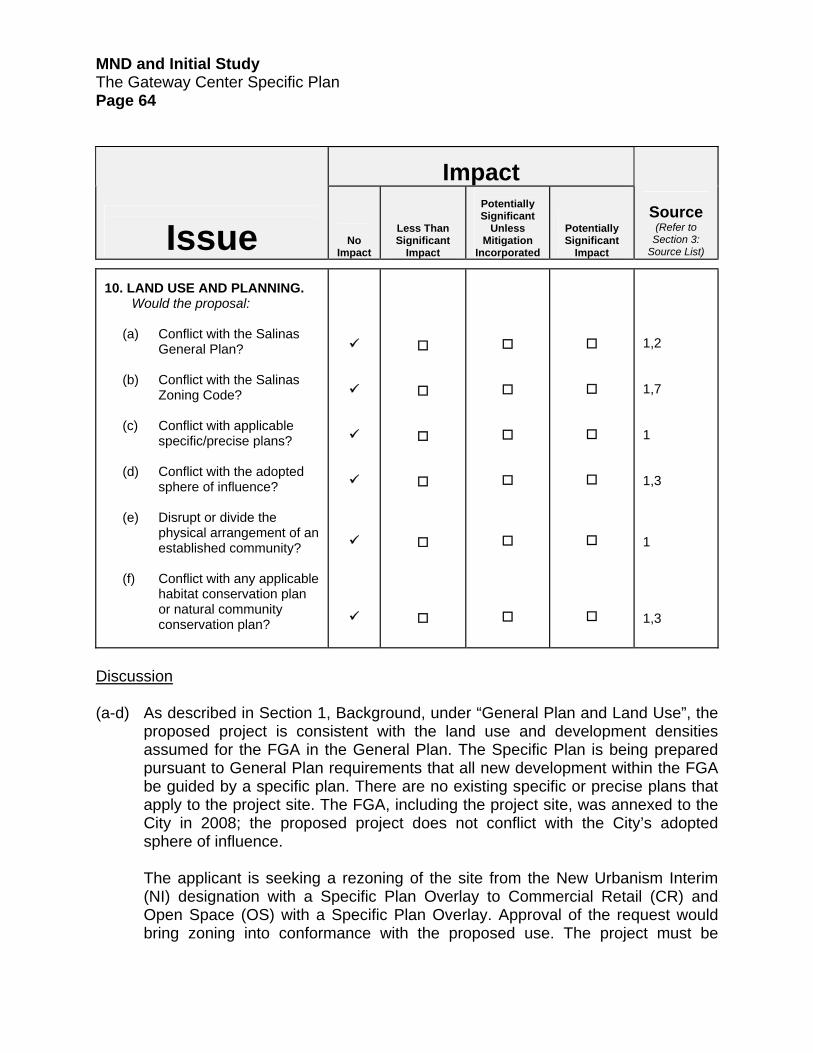
MND and Initial Study The Gateway Center Specific Plan Page 64
Impact
Issue
No Impact
Less Than Significant
Impact
Potentially Significant
Unless Mitigation
Incorporated
Potentially Significant
Impact
Source
(Refer to Section 3:
Source List)
10. LAND USE AND PLANNING.
Would the proposal:
(a) Conflict with the Salinas General Plan?
(b) Conflict with the Salinas
Zoning Code?
(c) Conflict with applicable specific/precise plans?
(d) Conflict with the adopted
sphere of influence?
(e) Disrupt or divide the physical arrangement of an established community?
(f) Conflict with any applicable
habitat conservation plan or natural community conservation plan?
1,2 1,7 1 1,3 1 1,3
Discussion (a-d) As described in Section 1, Background, under “General Plan and Land Use”, the
proposed project is consistent with the land use and development densities assumed for the FGA in the General Plan. The Specific Plan is being prepared pursuant to General Plan requirements that all new development within the FGA be guided by a specific plan. There are no existing specific or precise plans that apply to the project site. The FGA, including the project site, was annexed to the City in 2008; the proposed project does not conflict with the City’s adopted sphere of influence.
The applicant is seeking a rezoning of the site from the New Urbanism Interim (NI) designation with a Specific Plan Overlay to Commercial Retail (CR) and Open Space (OS) with a Specific Plan Overlay. Approval of the request would bring zoning into conformance with the proposed use. The project must be

MND and Initial Study The Gateway Center Specific Plan Page 65
designed consistent with the regulations and standards identified in the Zoning Code. Consistency with the regulations and standards will be assured through the City’s development review process. City staff has provided significant guidance to the applicant on the specific plan map, Specific Plan, and other project elements during the course of the project planning process regarding refinements to the project needed to ensure consistency with the Zoning Code.
(e) As described in Section 1, Background, under “General Plan and Land Use”, the
proposed project is consistent with land use and development density assumed for the FGA in the General Plan. Development of the vacant site has been planned for and is anticipated by the City as part of a coordinated long-term development planning process. Consequently, development of the site would be consistent with the planned physical arrangement of the City.
(f) The project site is not within a designated habitat conservation plan area.

MND and Initial Study The Gateway Center Specific Plan Page 66
Impact
Issue
No Impact
Less Than Significant
Impact
Potentially Significant
Unless Mitigation
Incorporated
Potentially Significant
Impact
Source
(Refer to Section 3:
Source List)
11.MINERAL & ENERGY
RESOURCES. Would the proposal:
(a) Result in the loss of
availability of a known mineral resource that would be of value to the region and the residents of the state?
(b) Result in the loss of
availability of a locally-important mineral resource recovery site delineated on a local general plan, specific plan or other land use plan?
1,3 1,3
Discussion (a-b) There are no known valuable mineral located within the project site or FGA.
Consequently, the General Plan does not delineate such resources within the site or FGA. The site is not within a Mineral Resource Zone as mapped by the state.
Regarding energy, the proposed project would result in an increase in energy demand that is commensurate with typical retail development. As discussed in Section 7, Greenhouse Gases, above, the proposed project includes a range of features that would reduce demand for electrical energy relative to “business as usual” retail development. Please refer to that section and to the Gateway Greenhouse Gas Report included in Appendix C, which is included on the CD found on the inside back cover of this document, for further information.

MND and Initial Study The Gateway Center Specific Plan Page 67
Impact
Issue
No Impact
Less Than Significant
Impact
Potentially Significant
Unless Mitigation
Incorporated
Potentially Significant
Impact
Source
(Refer to Section 3:
Source List)
12. NOISE. Would the proposal
result in:
(a) Exposure of persons to or generation of noise levels in excess of standards established in the local general plan or noise ordinance, or applicable standards of other agencies?
(b) Exposure of persons to or generation of excessive groundborne vibration or groundborne noise levels?
(c) A substantial permanent increase in ambient noise levels in the project vicinity above levels existing without the project?
(d) A substantial temporary or periodic increase in ambient noise levels in the project vicinity above levels existing without the project?
1,2,3,7,22 1,2,3,22 1,2,3,7,22 1,2,3,7,22

MND and Initial Study The Gateway Center Specific Plan Page 68
Impact
Issue
No Impact
Less Than Significant
Impact
Potentially Significant
Unless Mitigation
Incorporated
Potentially Significant
Impact
Source
(Refer to Section 3:
Source List)
(e) For a project located
within an airport land use plan or, where such a plan has not been adopted, within two miles of a public airport or public use airport, would the project expose people residing or working in the project area to excessive noise levels?
(f) For a project within the vicinity of a private airstrip, would the project expose people residing or working in the project area to excessive noise levels?
1,3 1,3
Discussion To evaluate potential noise impacts of the proposed project, Edward L. Pack Associates, Inc. prepared a noise assessment study. The study is entitled Noise Assessment Study for the Planned Gateway Specific Plan Commercial Center, East Boronda Road, Salinas (“noise assessment”) and is included in Appendix F, which is included on the CD found on the inside back cover of this document. The noise assessment (pages 2-3) describes General Plan Noise Element policies, Zoning Code noise regulations for delivery and loading dock operations, and standard CEQA practice for determining significance of noise increases for individual projects. Much of the information in this section is referenced from the noise assessment.
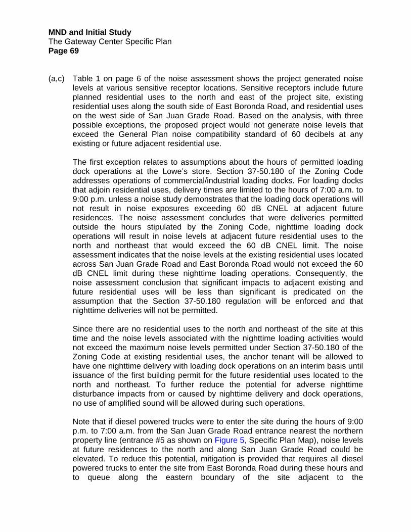
MND and Initial Study The Gateway Center Specific Plan Page 69
(a,c) Table 1 on page 6 of the noise assessment shows the project generated noise levels at various sensitive receptor locations. Sensitive receptors include future planned residential uses to the north and east of the project site, existing residential uses along the south side of East Boronda Road, and residential uses on the west side of San Juan Grade Road. Based on the analysis, with three possible exceptions, the proposed project would not generate noise levels that exceed the General Plan noise compatibility standard of 60 decibels at any existing or future adjacent residential use. The first exception relates to assumptions about the hours of permitted loading dock operations at the Lowe’s store. Section 37-50.180 of the Zoning Code addresses operations of commercial/industrial loading docks. For loading docks that adjoin residential uses, delivery times are limited to the hours of 7:00 a.m. to 9:00 p.m. unless a noise study demonstrates that the loading dock operations will not result in noise exposures exceeding 60 dB CNEL at adjacent future residences. The noise assessment concludes that were deliveries permitted outside the hours stipulated by the Zoning Code, nighttime loading dock operations will result in noise levels at adjacent future residential uses to the north and northeast that would exceed the 60 dB CNEL limit. The noise assessment indicates that the noise levels at the existing residential uses located across San Juan Grade Road and East Boronda Road would not exceed the 60 dB CNEL limit during these nighttime loading operations. Consequently, the noise assessment conclusion that significant impacts to adjacent existing and future residential uses will be less than significant is predicated on the assumption that the Section 37-50.180 regulation will be enforced and that nighttime deliveries will not be permitted. Since there are no residential uses to the north and northeast of the site at this time and the noise levels associated with the nighttime loading activities would not exceed the maximum noise levels permitted under Section 37-50.180 of the Zoning Code at existing residential uses, the anchor tenant will be allowed to have one nighttime delivery with loading dock operations on an interim basis until issuance of the first building permit for the future residential uses located to the north and northeast. To further reduce the potential for adverse nighttime disturbance impacts from or caused by nighttime delivery and dock operations, no use of amplified sound will be allowed during such operations. Note that if diesel powered trucks were to enter the site during the hours of 9:00 p.m. to 7:00 a.m. from the San Juan Grade Road entrance nearest the northern property line (entrance #5 as shown on Figure 5, Specific Plan Map), noise levels at future residences to the north and along San Juan Grade Road could be elevated. To reduce this potential, mitigation is provided that requires all diesel powered trucks to enter the site from East Boronda Road during these hours and to queue along the eastern boundary of the site adjacent to the

MND and Initial Study The Gateway Center Specific Plan Page 70
retention/detention basin. It also requires these trucks to not encroach (or park with the engine idling) within 100 feet of the common property line between the site and land to the north and east proposed for future residential use. The second exception relates to the setback distance between the north and northeastern property lines of the project site and future planned residential uses to the north and northeast. Noise levels at these future residential uses were estimated with the assumption that they would be setback from the common property line by a minimum of 80 feet. The 80-foot setback was assumed to consist of two components: a future approximately 20-foot wide trail and a 60-foot wide future local street. These features are included in conceptual development plans for the residential property to the north and northeast that the City has discussed with the owner of that property. If this 80-foot setback distance is not ultimately observed, noise levels at the residences would be greater than 60 dB CNEL even if loading dock operations are limited to 7:00 a.m. to 9:00 p.m. per Section 37-50.180 of the Zoning Code. This would result in an inconsistency with the General Plan noise compatibility standard. Developers of future residential development to the north and northeast will be required to locate residential uses a sufficient distance from the common property line to ensure that noise levels at those uses do not exceed 60 dB CNEL. The assessment of noise impacts at future residential uses to the north and east of the Lowe’s store is based on an assumption that noise standards limits are applied at the future property line of the residential uses. This was assumed given a proposed trail and a street are envisioned between the northern property line of the project site and the future property lines of the residential uses as part of the proposed development scenario for the West Area Specific Plan. Under this scenario, the actual property lines for these future residential uses would not abut the project site. If the noise limit standard is applied at the property line, noise levels from the proposed project at the property line would exceed the General Plan noise compatibility standard of 60 dB CNEL and a 14-foot high wall would be required along the northern and a portion of the eastern property line to mitigate the impact. It should be noted; however, that the wall would not mitigate the noise from nighttime loading operations on the future residential uses to the north. A 14-foot high wall would be aesthetically unappealing and have the potential for graffiti defacement. As such, mitigation would be required to reduce this impact to a less than significant level as described in mitigation measure N-1 below. This includes the provision of a noise attenuation (residential setback) easement in-lieu of the subject wall. The proposed project includes eight-foot high screen walls along the northern and eastern properly lines. However, these screen walls would not provide sufficient noise attenuation at the property line or at future residences as described above. Please see figures 3.2 and 3.3 of the Specific Plan for more detail on these proposed screen walls.

MND and Initial Study The Gateway Center Specific Plan Page 71
The noise assessment included analysis of potential noise impacts from project generated traffic volume increases. Modeling of noise levels along San Juan Grade Road and East Boronda Road showed that project generated traffic will add one decibel to existing and cumulative noise levels along these roads. The increase would not result in project-specific or cumulative traffic noise volumes that exceed City noise compatibility standards at noise sensitive residential uses along these roads. Analysis of potential noise impacts from operation of planned drive-thru retail services was also evaluated. Drive-thru uses are planned at the northernmost retail pad located along San Juan Grade Road (possible fast food restaurant) and at the easternmost retail pad located along East Boronda Road (possible pharmacy). Please refer back to Figure 5, Specific Plan Map, for the location of these pads. Noise from operation of a menu speaker board at the fast-food pad was modeled at the home along San Juan Road nearest the pad (shown on page 5 of the noise assessment). The noise level was estimated at up to 38 dBA in the rear yard, which would be barely audible between vehicle pass-bys. Assuming operating hours of 6:00 a.m. to 1:00 a.m. and a daily traffic volume of 550 vehicles through the fast-food drive-thru, traffic based noise exposure in the rear yard was calculated at 31 dB CNEL, which is well within the City’s noise compatibility standard. The pharmacy drive-thru was assumed not to have a menu board speaker. The drive-thru would face the internal project parking lot, not residential uses to the south across East Boronda Road. Consequently, noise from this drive-thru is not expected to be audible at these residences. Relative to compliance with CEQA, the noise assessment report concludes that noise increases from the project itself are less than significant as described on pages 2 and 7 of the noise assessment report. Mitigation Measures
N-1. An 80-foot off-site noise attenuation (residential setback) easement shall
be provided which includes land located between the northern and northeastern boundaries of the project site and planned future residences to the north and northeast of the project site. The easement is required to ensure that the City’s maximum noise exposure standard of 60 dB CNEL for residential uses as established in Zoning Code Section 37-50.180 is not exceeded due to noise generated by truck delivery and loading dock operations being conducted within the project site. The easement shall be provided by the applicant prior to issuance of the first building permit for the proposed project.

MND and Initial Study The Gateway Center Specific Plan Page 72
N-2. Loading dock activities shall be limited to 7:00 am to 9:00 pm daily in
conformance with City Zoning Regulations except that the anchor tenant may be permitted one nighttime delivery with related loading dock operations on an interim basis until issuance of the first building permit for future residential development to the north and northeast of the project site. The exception shall cease at that time unless a noise study is prepared as part of the future CEQA review process for adjacent future residential development which demonstrates to the satisfaction of the City Planner that maximum exposure noise levels at future adjacent residential uses will not exceed 60 dB CNEL (assuming that the delivery/loading dock exception will remain in place). Upon request, the applicant shall provide shipping and receiving documentation for review by the City Planner for conformance with the interim delivery/loading dock operations exception.
N-3. Amplified sound shall not be allowed at any time during nighttime loading
operations being conducted under the interim nighttime delivery/loading dock operations.
N-4. All delivery trucks with diesel powered engines entering the site during
nighttime hours shall use the most easterly driveway located off East Boronda Road for ingress to and egress from the site. These trucks shall queue along the east property line (along the detention/retention basin). Trucks with idling engines shall not queue/park within 100 feet of the common property lines between the site and the future residential uses to the north and northeast. This requirement shall be included in all vendor contract documents and the applicant shall post signage at appropriate locations throughout the project site informing vendors of this requirement. Signage shall be installed prior to issuance of an occupancy permit for any building.
(b) The City does not have specific vibration thresholds. Based on studies of
vibration conducted by the Federal Transit Administration, when there are fewer than 70 vibration events per day, a vibration velocity level of 80 VdB or greater will result in annoyance to people, and a level of 100 VdB or less is suggested to prevent damage to fragile buildings.
The most likely source of ground vibration during construction would be large bulldozers and loaded trucks. Typical bulldozer or loaded construction truck activities generate vibration levels of about 86-87 VdB at a distance of 25 feet and are likely to exceed 80 VdB at distances closer than 50 feet. There are no sensitive receptors within 50 feet of the project site, though sensitive residential land uses are located across both San Juan Grade Road and East Boronda Road from the site. Any groundborne vibration generated will not likely be 80

MND and Initial Study The Gateway Center Specific Plan Page 73
VdB or greater beyond 50 feet from the source, will be of minimal duration per event, and occur only over the short-term during the construction phase. Therefore, it is unlikely that vibration would occur at an intensity and duration that results in potentially significant impacts.
(c) Construction noise generated during site preparation and site development
activities would be a temporary source of elevated noise levels as described starting on page 8 of the noise assessment. When operating, construction equipment generates noise levels in the range of 60 to 80 dBA at a distance of 160 feet – the distance to the nearest existing residence. During a typical day of construction (7:00 a.m. to 7:00 p.m.) when heavy equipment is operating, noise levels at the nearest residential property lines could be up to 66 dB CNEL. Zoning Code Section 37-50.180 establishes that maximum noise levels at residential uses is limited to 60 dBA from 7:00 a.m. to 9:00 p.m. and 5 dB lower during night time hours. Further, noise levels may exceed 60 dBA by up to 10 dBA, or 70 dBA, for a period of one minute or less in any one hour.
While the noise intensity level associated with periodic use of construction equipment could exceed these standards, it would likely be reached only temporarily and most commonly during initial site preparation activities when heavy equipment is most commonly in use. Once the initial site preparation phase is completed, it is likely that noise levels would decline during the longer period while buildings are being constructed. During long-term operations, commercial activities at the project site would not be expected to generate temporary, high intensity noise, as commercial uses do not typically employ equipment or conduct activities that are sources of such noise.
(e,f) The project site is located approximately four miles from the Salinas Municipal Airport and is not within the airport Area of Influence. There are no private airstrips within the project vicinity.

MND and Initial Study The Gateway Center Specific Plan Page 74
Impact
Issue
No Impact
Less Than Significant
Impact
Potentially Significant
Unless Mitigation
Incorporated
Potentially Significant
Impact
Source
(Refer to Section 3:
Source List)
13. POPULATION AND HOUSING.
Would the proposal:
(a) Cumulatively exceed official regional or local population projections?
(b) Induce substantial growth
in an area either directly or indirectly (e.g. through projects in an undeveloped area or extension of major infrastructure)?
(c) Displace substantial
numbers of existing housing, especially affordable housing, necessitating the construction of replacement housing elsewhere?
(d) Displace substantial numbers of people, necessitating the construction of replacement housing elsewhere?
1,2,3 1,2,3 1,2,3 1,2,3
Discussion (a) The proposed project will not generate a direct increase in population growth.
Therefore, it will not conflict with population projections. (b) The project site is within the City’s FGA. Development of the FGA is a
component of the City’s planned long-term growth as identified in the General Plan. Infrastructure needed to support development of the site and the FGA has already been planned and evaluated. Hence, development of the site will not

MND and Initial Study The Gateway Center Specific Plan Page 75
induce growth on adjacent undeveloped parcels that has not already been contemplated, planned, and evaluated for environmental impacts by the City.
(c,d) The project site and surrounding properties are undeveloped. Development of
the site would not result in the loss of existing housing or displace existing population.
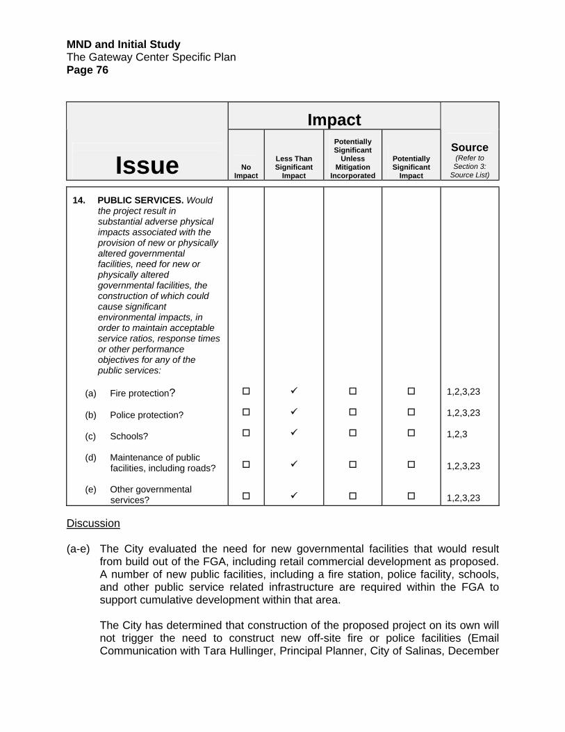
MND and Initial Study The Gateway Center Specific Plan Page 76
Impact
Issue
No Impact
Less Than Significant
Impact
Potentially Significant
Unless Mitigation
Incorporated
Potentially Significant
Impact
Source
(Refer to Section 3:
Source List)
14. PUBLIC SERVICES. Would
the project result in substantial adverse physical impacts associated with the provision of new or physically altered governmental facilities, need for new or physically altered governmental facilities, the construction of which could cause significant environmental impacts, in order to maintain acceptable service ratios, response times or other performance objectives for any of the public services:
(a) Fire protection?
(b) Police protection?
(c) Schools?
(d) Maintenance of public
facilities, including roads?
(e) Other governmental services?
1,2,3,23 1,2,3,23 1,2,3 1,2,3,23 1,2,3,23
Discussion (a-e) The City evaluated the need for new governmental facilities that would result
from build out of the FGA, including retail commercial development as proposed. A number of new public facilities, including a fire station, police facility, schools, and other public service related infrastructure are required within the FGA to support cumulative development within that area.
The City has determined that construction of the proposed project on its own will not trigger the need to construct new off-site fire or police facilities (Email Communication with Tara Hullinger, Principal Planner, City of Salinas, December

MND and Initial Study The Gateway Center Specific Plan Page 77
9, 2010). The proposed project will not generate new population, so there will be no increase in demand for school facilities. No other public service related facilities need to be constructed off-site to meet demands from the project. Consequently, the proposed will not result in the need for any new or altered governmental facilities whose construction could result in environmental impacts.

MND and Initial Study The Gateway Center Specific Plan Page 78
Impact
Issue
No Impact
Less Than Significant
Impact
Potentially Significant
Unless Mitigation
Incorporated
Potentially Significant
Impact
Source
(Refer to Section 3:
Source List)
15. RECREATION. Would the
proposal:
(a) Increase the use of existing neighborhood and regional parks or other recreational facilities such that substantial physical deterioration of the facility would occur or be accelerated?
(b) Include recreational facilities or require the construction or expansion of recreational facilities which might have an adverse physical effect on the environment?
2
2
(a,b) The proposed project will not result in an increase in demand for recreational
services in the City as it will not result in an increase in local or regional population. The project does not include recreational facilities or require the construction of recreational facilities. The project does include a walking trail to improve pedestrian connectivity. The trail is located on-site and provides a connection to an off-site pedestrian trail that will link the site to the remainder of the FGA. The effects of its construction are addressed as part of the overall analysis of project effects as described in this Initial Study.

MND and Initial Study The Gateway Center Specific Plan Page 79
Impact
Issue
No Impact
Less Than Significant
Impact
Potentially Significant
Unless Mitigation
Incorporated
Potentially Significant
Impact
Source
(Refer to Section 3:
Source List)
16. TRANSPORTATION &
CIRCULATION. Would the project:
(a) Conflict with an applicable
plan, ordinance or policy establishing measures of effectiveness for the performance of the circulation system, taking into account all modes of transportation including mass transit and non-motorized travel and relevant components of the circulation system, including, but not limited to intersections, streets, highways and freeways, pedestrian and bicycle paths, and mass transit?
(b) Conflict with an applicable
congestion management program, including, but not limited to level of service standards and travel demand measures or other standards established by the county congestion management agency for designated roadways or highways?
(c) Result in a change in air traffic patterns, including either an increase in traffic levels or a change in location that results in substantial safety risks?
1,2,3,4,7, 24 1,2,3,4,7, 24 1,3

MND and Initial Study The Gateway Center Specific Plan Page 80
Impact
Issue
No Impact
Less Than Significant
Impact
Potentially Significant
Unless Mitigation
Incorporated
Potentially Significant
Impact
Source
(Refer to Section 3:
Source List)
(d) Substantially increase hazards due to a design feature (e.g., sharp curves or dangerous intersections) or incompatible uses (e.g., farm equipment)?
(e) Result in inadequate emergency access?
(f) Conflict with adopted
policies, plans, or programs regarding public transit, bicycle, or pedestrian facilities, or otherwise decrease the performance or safety of such facilities?
(g) Conflicts with vehicle trip reduction requirements in accordance with the Salinas Zoning Code?
(h) Conflicts with airport
operations?
1,2,3,4,7, 24 2,24 1,2,3,4,24,25 2,7 1,2,3
Discussion
(a,b) To evaluate whether the proposed project would conflict with City and/or Caltrans
measures for performance of the vehicular and non-vehicular circulation network in the project site vicinity, the City retained Fehr & Peers, Transportation Consultants, to prepare a transportation impact analysis (TIA). The TIA, entitled Salinas Cloverfield) Retail Center Transportation Impact Analysis was completed in December 2010. The TIA is included as Appendix G, which is included on the CD found on the inside back cover of this document. The TIA analyzed existing conditions, existing plus project conditions, cumulative conditions without the project, and cumulative conditions with the project for vehicular effects and for pedestrian, bicycle, and transit effects of the project. The information in this discussion is summarized from analysis included in the TIA. The scope of the TIA was informed through early consultation with the City, Monterey County, the

MND and Initial Study The Gateway Center Specific Plan Page 81
Transportation Agency for Monterey County, and Caltrans. Fehr & Peers’ responses to comments made by these agencies are included in a letter that is included at the back of Appendix G.
The TIA included analysis of 12 intersections, four roadway segments, and four
U.S. Highway 101 segments located north and south of the U.S. 101/Boronda Road interchange. An assumption is made that due to the commercial nature of the project, only a minimal amount of traffic will be generated during the AM peak period and the surrounding roadways will not be substantial affected during this period. Consequently, the analysis focuses on project impacts on the circulation network during the PM peak period. For informational purposes, the TIA also includes a Saturday mid-day analysis. The Saturday analysis is not utilized as the basis for impact assessment as this condition occurs only once per week relative to the PM peak hour condition, which occurs more frequently. The project is projected to generate 826 net new PM peak-hour trips (405 inbound and 421 outbound).
Please refer back to Figure 6, Vehicular Access and Internal Circulation and to
Section 4, Circulation, of the Specific Plan for more information on improvements planned along the project site frontages with San Juan Grade Road and East Boronda Road. The applicant, City Engineer, and Fehr & Peers coordinated efforts for planning roadway and frontage improvements in these locations to ensure City standards for circulation would be met. Improvement plans in the Specific Plan reflect the outcome of this planning effort. Traffic Impact/Mitigation Summary – City Circulation System Existing Plus Project Conditions. The addition of project traffic to the existing circulation network would result in significant impacts at one of the 12 intersections evaluated. Under existing plus project conditions, a significant impact on operations of the East Boronda Road/San Juan Grade Road would occur based on the existing lane configuration of this intersection as described beginning on page 29 of the TIA. The City’s Level of Service (LOS) standard for intersections is LOS D. Addition of project traffic would reduce operations from LOS D to LOS E. This impact can be mitigated to a less than significant level by constructing an eastbound left turn lane consistent with the City’s Transportation Improvement Program project #50 and the City Public Works Department active project #9510. After the TIA was prepared, the City completed improvements to the intersection consistent with improvements described in active project #9510. Consequently, this project impact has subsequently been reduced to a less than significant level. The applicant will be required to pay traffic impacts fees consistent with the City’s Traffic Fee Ordinance as the project’s fair share contribution to the costs of

MND and Initial Study The Gateway Center Specific Plan Page 82
improvements to the intersection. Payment of such fees is required as a standard condition of approval. Cumulative Conditions. Under cumulative conditions, the Boronda Road/North Main Street, East Boronda Road/McKinnon Street, and East Boronda Road/San Juan Grade Road intersections would be significantly impacted as described starting on page 43 of the TIA. Operations at these intersections would degrade from LOS D to E, LOS D to E, and LOS E to F, respectively. The impact at the Boronda Road/North Main Street intersection can be mitigated to a less than significant level by widening the eastbound approach to include a third lane. This improvement is not programmed or funded by the City. The City anticipates modifying its Traffic Fee Ordinance to include this improvement. If this is done, the applicant’s payment of traffic impact fees to the City would mitigate this impact to a less than significant level. If the Traffic Fee Ordinance is not modified for this purpose, other sources of funds must be identified prior to project approval or the City may enter into a reimbursement agreement with the applicant to construct the improvement. Implementation of the following mitigation measure would be required to reduce this impact to a less than significant level if the Traffic Fee Ordinance is not modified prior to project approval: Mitigation Measure
TRANS-1. A funding source for the Boronda Road/North Main intersection
improvements as defined in the Salinas (Cloverfield) Retail Center Transportation Impact Analysis must be identified and in place prior to the City Engineer’s issuance of a grading permit for the proposed project. The funding source may be traffic impact fees collected from the applicant pursuant to modification of the City’s Traffic Fee Ordinance to include the improvement or a reimbursement or other agreement with the applicant requiring the applicant to fund the improvement.
Improvements required at the East Boronda Road/McKinnon Street intersection, which are second through lanes in the eastbound and westbound directions, are included in the City’s Traffic Improvement Program project #20. The applicant’s payment of traffic impacts fees consistent with the City’s Traffic Fee Ordinance would reduce this impact to a less than significant level. Payment of this fee is a standard condition of approval. Mitigation of cumulative impacts at the East Boronda Road/San Juan Grade Road intersection requires that a second left-turn lane on all approaches be installed. This improvement is consistent with the City’s Traffic Improvement Program project #50. As noted above for existing plus project conditions, this

MND and Initial Study The Gateway Center Specific Plan Page 83
improvement has recently been completed. The applicant will be required to pay traffic impact fees consistent with the City’s Traffic Fee Ordinance as the project’s fair share contribution to the costs of improvements to the intersection. Payment of this fee is a standard condition of approval. Traffic Impact/Mitigation Summary – Caltrans Circulation System Project and Cumulative Conditions. The project will have a significant impact on two of the four U.S. Highway 101 freeway mainline segments evaluated: 1) U.S. Highway 101 between Laurel Drive and Boronda Road; and 2) U.S. Highway 101 between Boronda Road and Russell Road. Impacts on these highway segments from build out of the City’s FGA, of which the project is a part, were identified in the SEIR as significant and unavoidable. The City adopted a Statement of Overriding Consideration for these impacts in 2007. As described in Section 1.0, Background, under “General Plan and Land Use”, the proposed project is consistent with the land use and development density for the FGA as established in the General Plan. Pursuant to CEQA Guidelines section 15183, CEQA requires that projects which are consistent with the development density established by existing zoning, community plan, or general plan policies for which an EIR was certified shall not require additional environmental review, except as might be necessary to examine whether there are project-specific significant effects which are peculiar to the project or its site. The project specific impacts on these U.S. Highway 101 segments are not peculiar to the project or its site, having already been identified as noted above. Consequently, no further evaluation of project impacts on U.S. Highway 101 mainline segments is required. Further, CEQA Guidelines Section 15183(c) states, “If an impact is not peculiar to the parcel or to the project, has been addressed as a significant effect in the prior EIR, or can be substantially mitigated by the imposition of uniformly applied development policies or standards, as contemplated by subdivision (e) below, then an additional EIR need not be prepared for the project solely on the basis of that impact.”
Widening of U.S. Highway 101 to six lanes between the Russell Road interchange and Harris Road is included in the City’s Traffic Improvement Program as project #32. The applicant will be required to pay traffic impacts fees consistent with the City’s Traffic Fee Ordinance (a uniformly applied development standard). Payment of this fee is a standard condition of approval. No additional mitigation is required.

MND and Initial Study The Gateway Center Specific Plan Page 84 Pedestrian and Bicycle Circulation Impact/Mitigation Summary
The project is expected to generate pedestrian traffic in the form of customers and employees that will access bus stops planned on the site, commercial services on East Boronda Road and San Juan Grade Road, and residential areas to the south and west. The proposed project includes sidewalks along its frontages with East Boronda Road and San Juan Grade Road as required by the City. Providing pedestrian connectivity throughout the FGA is an important policy goal for the City. To promote pedestrian connectivity within the site, to adjacent future development sites within the FGA, and to proposed transit stops, sidewalks are provided throughout the site and a six-foot wide pedestrian path is provided along the eastern edge of the parking lot to connect the East Boronda Road sidewalk directly to the Lowe’s building and to current undeveloped parcels to the north and east. Figure 4.4 of the Specific Plan on page illustrates the pedestrian circulation plan. Crosswalks will be provided at the San Juan Grade Road/Northridge Way and East Boronda Road/Dartmouth Way intersections with signalization planned as part of the proposed project. The proposed project provides pedestrian facilities that meet the increased demand created, and that promote connectivity throughout the site with future adjacent development and with adjacent existing commercial and residential development.
Bicycle lanes will be provided on the East Boronda Road and San Juan Grade Road frontages. The improvements are consistent with the bicycle path system presented in the General Plan Circulation Element. Together, existing and newly constructed bicycle facilities can accommodate the increase in demand generated by the project and the project will not conflict with any planned bicycle facility. Bicycle parking will be provided consistent with Salinas Municipal Code Section 37-50.400, which requires that the number of bicycle spaces shall be 10 percent of the required auto spaces. Transit Circulation Impact/Mitigation Summary Monterey-Salinas Transit provides transit service in Salinas. The project site is located along Monterey-Salinas Transit’s existing Route 45, which travels San Juan Grade Road and East Boronda Road. Several other routes service the Northridge Mall and the Harden Ranch Plaza commercial shopping centers located in the immediate vicinity of the project site. As shown on Figure 5, Specific Plan Map, two new bus stops are proposed as part of the proposed project. One is located along the project frontage with East Boronda Road and the other along the San Juan Grade Road frontage. The East Boronda Road stop will replace an existing, minimally improved stop. The bus stops are consistent with General Plan policy that promotes the use of alternative

MND and Initial Study The Gateway Center Specific Plan Page 85
transportation modes and construction of facilities for this purpose. Monterey-Salinas Transit has transit facility design standards with which bus stop improvements must be consistent. The applicant has consulted with Monterey-Salinas Transit about the improvement requirements and the location and design of the stop pullouts as shown on the project specific plan map is consistent with input from the City and Monterey-Salinas Transit. The applicant will be required to prepare improvement plans for and construct the bus stops consistent with these standards (Email Communication with Dexter Chu, Cloverfield Management LLC, December 8, 2010).
(c) The proposed project would not generate air traffic nor affect air traffic patterns. (d,e) The applicant, City staff, and the City’s consulting traffic engineer have
collaborated on the specific plan map design to ensure that ingress and egress and on-site circulation conditions address potential safety and accessibility issues. The specific plan map design has been refined in consideration of these issues.
(f) Please refer to item (a,b) above. The applicant is providing pedestrian, bicycle,
and transit connectivity and improvements consistent with City requirements. The project will not conflict with related General Plan policies and is expected to be consistent with City standards regarding pedestrian, bicycle, and transit access and design as specified in the Salinas Municipal Code, most notably Part II, Article V, Supplemental Regulations Applying to All Districts.
(g) Salinas Municipal Code Section 37.50.330 specifies requirements for vehicle trip
reduction. Commercial projects that generate more than 2,500 average daily trips must prepare a facilities trip reduction plan. The proposed project would generate daily trips in excess of this threshold. The trip reduction plan must demonstrate improvements or actions that result in a one and six-tenths percent per year trip reduction, one and thirty-five hundredths average vehicle ridership rate, and/or a sixty percent drive-alone rate. The proposed project already incorporates a range of fundamental improvements/actions that are typically used to reduce vehicle trip numbers (i.e. sidewalks/trails/pedestrian connectivity, bicycle lanes, transit stops, etc.). A draft Facilities Traffic Management Plan is included in the Specific Plan as Appendix A. Given this fact, it is not anticipated that the project will conflict with the City’s effort to reduce vehicle trips from commercial development via implementation of trip reduction plans.
(h) The project site is located approximately four miles from the Salinas Municipal
Airport. The site is not within the Area of Influence for the airport. Lighting, glare, or vertical obstructions that could adversely affect airport operations would not occur.

MND and Initial Study The Gateway Center Specific Plan Page 86
Impact
Issue
No Impact
Less Than Significant
Impact
Potentially Significant
Unless Mitigation
Incorporated
Potentially Significant
Impact
Source
(Refer to Section 3:
Source List)
17. UTILITIES & SERVICE
SYSTEMS. Would the project:
(a) Exceed wastewater treatment requirements of the applicable Regional Water Quality Control Board?
(b) Require or result in the
construction of new water or wastewater treatment facilities or expansion of existing facilities, the construction of which could cause significant environmental effects?
(c) Require or result in the
construction of new storm water drainage facilities or expansion of existing facilities, the construction of which could cause significant environmental effects?
(d) Have sufficient water
supplies available to serve the project from existing entitlements and resources, or are new or expanded entitlements needed?
(e) Result in a determination
by the wastewater treatment provider which serves or may serve the project that it has the adequate capacity to serve the project's projected demand in addition to the provider's existing commitments?
1,2,3,4 1,2,3,4 1,2,3,4,20,21 1,2,3,4 1,2,3,4

MND and Initial Study The Gateway Center Specific Plan Page 87
Impact
Issue
No Impact
Less Than Significant
Impact
Potentially Significant
Unless Mitigation
Incorporated
Potentially Significant
Impact
Source
(Refer to Section 3:
Source List)
(f) Be served by a landfill with
sufficient permitted capacity to accommodate the project's solid waste disposal needs?
(g) Comply with federal, state, and local statues and regulations related to solid waste?
1,2,3,4,26, 27 1,2,3
Discussion (a,b,e) Wastewater treatment demand and the capability of the Monterey Regional
Water Pollution Control Agency to provide treatment capacity within its facilities that serve the City (Salinas Pump Station, interceptor line, and regional wastewater treatment facility) were fully evaluated in the SEIR starting on page 5.2-1. The SEIR concludes that with implementation of policy mitigation measures contained in the GP EIR and additional mitigation measures described in the SEIR, wastewater treatment demand at build out of the FGA, including the project site, can be accommodated without the need to expand the wastewater treatment plant. The SEIR also notes that build out of the FGA will contribute to the eventual need for expansion of the treatment facility in consideration of cumulative development within the Monterey Regional Water Pollution Control Agency’s service area.
The GP EIR and SEIR mitigations applicable to the proposed project require new development to reduce water demand by 15 percent; require the City to review development proposals, require related necessary wastewater studies, and impose water conservation measures and other mitigation measures to ensure adequate sewer service; and require the City to confirm the availability of adequate sewage treatment capacity prior to the approval of all tentative subdivision maps within the FGA.
As stated in Section 5.4.1, Existing Sanitary Sewer System, in the Specific Plan, Monterey Regional Water Pollution Control Agency staff has recently confirmed that existing plant capacity is about 29.6 million gallons per day. Existing capacity

MND and Initial Study The Gateway Center Specific Plan Page 88
availability and projections of future capacity availability have not been substantively modified by the Monterey Regional Water Pollution Control Agency since the SEIR was certified in 2007. Hence, no new information is available that would suggest the conclusions reached in the SEIR are no longer applicable. Further, as described in Section 1, Background, under “General Plan and Land Use” of this Initial Study, the proposed project is consistent with the land use plan for the FGA. The FGA land use plan was used as a basis to assess potential impacts of build out of the FGA on regional wastewater conveyance and treatment facilities in the SEIR. Given these factors, the proposed project would not result in significant impacts on the ability of the Monterey Regional Water Pollution Control Agency to provide wastewater treatment service to the proposed project that have not already been considered and mitigated to a less than significant level. The SEIR (page 5.2-10) identified the general potentially significant environmental effects of constructing and operating an expanded regional wastewater treatment plant. The proposed project would contribute to these potential effects, which the SEIR concludes will be evaluated in detail if and when an expansion project is proposed. The City issued a Will Serve Letter for the proposed project that is included in Appendix D of the Specific Plan. This demonstrates that the City has the ability to provide infrastructure that will convey wastewater from the project site to wastewater treatment facilities operated by the Monterey Regional Water Pollution Control Agency. The applicant will also be required to obtain a sewer connection permit from the Monterey Regional Water Pollution Control Agency and pay a fee for the capacity to be utilized and to cover fair-share treatment service capital costs.
(c) The proposed project includes construction of a stormwater detention/retention basin. The basin is designed to meet the stormwater retention requirements of the project and can be expanded in the future to meet demand of a portion of future development planned within the FGA located north of East Boronda Road as described in the General Plan. The potential incremental effects of constructing the stormwater detention facility include: aesthetics, air quality, hydrology, and water quality. These effects are discussed in their respective sections of this Initial Study and were previously addressed at a program level in the GP EIR and SEIR. None of the potential impacts of constructing the facility fall outside the scope of potential impacts identified for the proposed project as a whole. Project consistency with City policies, regulations, and standards and implementation of related mitigation measures included in this Initial Study will ensure that potential effects of constructing the retention facility will be less than significant.

MND and Initial Study The Gateway Center Specific Plan Page 89
(d) The availability of sufficient water supply to meet demand from build out of the FGA, including the proposed project, and the need to construct new water supply facilities were fully evaluated in the SEIR starting on page 5.3-1. Additional information is included in the Specific Plan in Section 5.3, Water Supply.
Using prior analyses conducted on historical agricultural water demand within the FGA, the applicant has calculated that the existing agricultural use of the site results in a net consumptive water demand of about 37.3 to 44.5 acre-feet per year, with an average of 40.9 acre-feet per year. Demand from the proposed project is estimated at approximately 10.65 acre-feet per year. The conversion from agricultural use to urban use is; therefore, anticipated to result in an increase of approximately 30.25 acre-feet per year of water recharged to groundwater. This conclusion is consistent with assumptions made in the SEIR as discussed below regarding water balance with the FGA resulting from its conversion from agricultural to urban uses.
The project site is within the service area of Cal Water, which is the water
purveyor for much of the City. As part of the Water Supply Assessment prepared for the proposed annexation of the FGA, Cal Water determined that converting agricultural land within the FGA to urban use would have a net positive effect by increasing regional groundwater storage by an estimated 1,737 acre-feet per year. However, a water balance study performed by Wood Rodgers demonstrated that either slightly more or slightly less water could be used as the FGA is converted to urban use. Therefore, the change in the amount of water used as the Annexation area is converted to urban use was deemed inconclusive in the SEIR.
In its Water Supply Assessment, Cal Water indicated that it has sufficient access to water and adequate water supply to serve development within the FGA, including through the year 2027. However, the SEIR notes that provision of water by Cal Water and other providers will likely contribute to the on-going overdraft condition in the Salinas Valley Groundwater Basin, which could exacerbate seawater intrusion and nitrate contamination (please refer to Section 8, Hydrology and Water Quality of this Initial Study for more discussion of water quality issues). The SEIR concluded that it is uncertain whether an adequate supply of good quality water would be available in the long term (more than 20 years in the future) to serve the FGA, even with implementation of mitigation measures included in the GP EIR. Consequently, this impact was found to be significant and unavoidable. In 2010, the City certified the Salinas-Ag Industrial Center Final EIR. That EIR concluded on page 2-99 that the Monterey County Water Resource Agency’s implementation of the Salinas Valley Water Project would halt further seawater intrusion from continued pumping of the Salinas Groundwater Basin needed to
MND and Initial Study The Gateway Center Specific Plan Page 90
meet projected water demand in Salinas at General Plan build out. Consequently, the impacts of the Salinas-Ag Industrial Center on groundwater quality due to exacerbation of seawater intrusion from ground water pumping were found to be less than significant. Assuming the Salinas Valley Water Project will halt continued seawater intrusion, the uncertainty about ground water supply availability as discussed in the SEIR would be substantially diminished. To demonstrate that adequate water supply availability for the project exists, the applicant requested and received a Will-Serve letter from Cal Water dated December 7, 2010 in which Cal Water stated that it has sufficient supply to serve the proposed project. The letter is included in Appendix C of the Specific Plan. As described in Section 1.0, Background, under “General Plan and Land Use”, the proposed project is consistent with the land use and development density for the FGA as established in the General Plan. Pursuant to CEQA Guidelines Section 15183, CEQA requires that projects which are consistent with the development density established by existing zoning, community plan, or general plan policies for which an EIR was certified shall not require additional environmental review, except as might be necessary to examine whether there are project-specific significant effects which are peculiar to the project or its site. The project specific impacts on water supply availability are not peculiar to the project or its site, having already been identified as noted above. Consequently, no further evaluation of this impact is required.
(f) Section 6.4, Solid Waste, in the Specific Plan includes background information
on Salinas Valley Solid Waste Authority waste disposal facilities and services. The Salinas Valley Solid Waste Authority operates landfills and transfer stations designed to accommodate the long-term solid waste disposal needs of customers within its service area, which includes the City. Republic Services will provide solid waste collection services for the site.
As determined by the applicant using a representative solid waste generation factor for a commercial shopping center from CalRecycle (formerly the California Integrated Waste Management Board) of approximately six pounds per 1,000 square feet per day, the proposed project would generate about 1,236 pounds of solid waste per day. This generation rate is similar to the seven pounds per 1,000 square feet rate for all commercial uses identified in the GP EIR. The CalRecycle rate was utilized because it is specific to commercial shopping centers. The Salinas Valley Solid Waste Authority has sufficient capacity in its existing Johnson Canyon landfill to accommodate solid waste from the proposed project. The Salinas Valley Solid Waste Authority is working on a comprehensive plan to provide solid waste disposal capacity for approximately 70 years as described in its Information Handbook dated January 2010. As part of its effort to increase
MND and Initial Study The Gateway Center Specific Plan Page 91
long-term capacity to accept solid waste, the Salinas Valley Solid Waste Authority is actively exploring waste conversion technology options.
(g) The primary relevant state regulation pertaining to the proposed project is
California Assembly Bill 939, which requires cities and counties to divert 50 percent of their solid waste from landfills. The Salinas Valley Solid Waste Authority is meeting its mandate to meet Assembly Bill 939 requirements.

MND and Initial Study The Gateway Center Specific Plan Page 92
Impact
Issue
No Impact
Less Than Significant
Impact
Potentially Significant
Unless Mitigation
Incorporated
Potentially Significant
Impact
Source
(Refer to Section 3:
Source List)
18. URBAN DECAY. Would the proposal:
(a) Create market competition
which creates economic effects that result in closure of retail stores, resulting in building decay/blight?
29,30,31
Discussion The proposed project would introduce a new 152,500 square-foot home improvement and garden center store to the City. This section of the Initial Study provides an overview of the potential for the new store to create market competition that results in vacancies and decay of existing stores. (a) Background and Definition. The conditions under which urban decay effects are
to be evaluated under CEQA arises largely from the California Court of Appeals in a case entitled Bakersfield Citizens for Local Control v. City of Bakersfield (2004). In this case, the court required the City to recirculate two EIRs because they did not evaluate the possible indirect physical effects that construction of two Walmarts may create as a result of their direct economic effects. The court determined that “when the economic or social effects of a project cause a physical change, the change is to be regarded as a significant effect in the same manner as any other physical change resulting from the project.” In this situation, the court determined than analysis of urban decay under CEQA is required. The court did not provide a specific definition of urban decay, but was generally seen to consider this effect as a “chain reaction of store closures and long-term vacancies, ultimately destroying existing neighborhoods and leaving decaying shells in their wake.”
There is no one specific accepted definition of urban decay, but those which are used do mirror the concept of the issue as described in the Bakersfield case noted above. For purposes of the analysis in this Initial Study, urban decay is defined as follows:

MND and Initial Study The Gateway Center Specific Plan Page 93
Urban decay is the closure of retail stores in the area due to market competition, which subsequently results in long-term building vacancies, abandonment, and physical deterioration.
Consideration of urban decay effects of new development projects have, as in the Bakersfield case, often focused on direct economic effects of “supercenter” stores such as Walmart Supercenters or Super Target stores on local downtown retailers. Supercenter stores are often characterized as large retailers who stock and sell a wide variety of merchandise including groceries, clothing and general supplies, or large stores that sell a massive quantity of goods in one product line such as electronics or shoes. In the case of the proposed project, the potential for urban decay focuses on the potential effects of constructing a 152,500 square-foot home improvement and garden center. This type of retail establishment is not considered a supercenter. Nevertheless, the City felt it prudent to examine potential urban decay effects of this component of the proposed project. The remaining 55,000 square-feet of retail/services proposed are not expected to be at issue as they will be occupied by small retail/services tenants whose individual direct economic effects are not likely to be substantial enough to result in abandonment of other buildings that house similar businesses. Impact Evaluation Methodology. A common way to estimate the potential for urban decay is to estimate the amount of existing and projected retail “leakage” and/or sales surplus in a community. Leakage represents the difference between the amount of spending by local residents/transient visitors to a community and the amount of sales of local retailers. A large volume of leakage for specific types of goods or services indicates that a community is losing sales to retailers outside of the community. Consequently, there may be a high potential for new retail establishments selling those same goods or services to be absorbed into the local market based on unmet local demand. Conversely, if the local supply of specific goods or services is significantly greater than the local community demand, it is likely that the community is capturing sales from the local market plus attracting non-local shoppers. A retail surplus does not mean that the local community cannot support additional businesses. Rather, it may indicate that the community may have developed strong clusters of stores that have become destination retailers which draw customers from outside the area. If potential for absorption of new retail businesses exists based on the results of a leakage/sales surplus analysis, there is a reduced potential that the new business will out-compete existing businesses selling similar products or services. The potential for existing businesses to fail is reduced; and therefore, so is the potential for long-term vacancy or abandonment of buildings housing similar businesses.

MND and Initial Study The Gateway Center Specific Plan Page 94
In 2008 the City retained Buxton economics consultants to evaluate retail leakage and surplus conditions for a market area within 20 minutes driving time of the concentration of commercial development located in the Boronda Road/U.S. Highway 101 area of the City. A key goal of the leakage/surplus analysis was to identify possible retail growth opportunities for the area. This area is located approximately one-third mile to the west of the project site, so conditions in that area are considered to be representative of those at the project site. Buxton also prepared a “Retail Match List” for the area which identifies a range of representative retailers that would be a good match for area based on the leakage/surplus analysis results. Results of Buxton’s evaluation are included in a report entitled Retail Leakage and Surplus Analysis – Northridge. The report is available at: http://www.ci.salinas.ca.us/services/economic/econ_dev.cfm. Buxton evaluated supply and demand across 36 product categories and reported results in the form of a leakage/surplus index for each. The leakage/surplus index provides a relative comparison of the supply and demand for a product category. It is calculated by dividing actual sales by potential sales. An index greater than 1.0 means that the community is attracting retail sales from customers outside the trade area. If the index is less than 1.0 it means that out-shopping is taking place and the community is not successfully drawing its own residents – shoppers are traveling outside the City to purchase the product or service.
The product category which best matches the products sold by Lowe’s home improvement stores is “Hardware, Tools, Plumbing, and Electrical Supplies”. The leakage/surplus index for this product category was calculated by Buxton as 1.7. This result indicates that the City is both a strong local and regional destination for sales within this product category. In fact, of the 36 categories evaluated, this category shows the highest surplus index value. Other related product categories (i.e. lumber and building materials and paint and sundries) also show an index value that is greater than 1.0. Based on this information, it appears that sales volume within this category is substantial enough to support absorption of additional retailers within this product category. Buxton’s Retail Match List reflects this assumption given that it lists Lowe’s as a good match for the City based on the City’s retail sales profile. Buxton completed similar leakage/surplus studies for other areas of retail concentration in the City. For all areas, the index value for the “Hardware, Tools, Plumbing, and Electrical Supplies” category was 1.5 or greater and Lowe’s was also identified as a good end user match for those areas. The City’s ability to absorb a Lowe’s store is further supported by data obtained from Lowe’s. The Lowe’s store nearest the City is located in Gilroy, approximately 25 miles away. For the period March 2009 to March 2010, Lowe’s Gilroy store tens of thousands of transactions from customers originating within the Salinas trade area. The trade area includes Salinas, cities on the Monterey

MND and Initial Study The Gateway Center Specific Plan Page 95
Peninsula, cities in the Salinas Valley south to Gonzales, and nearby areas of Monterey County. The total value of the transactions was about $4,100,000 (Email Communication from Lori Chase, Lowe’s Market Research Manager, March 19, 2010). This indicates that despite the fact that the City is a regional draw for sales in the Hardware, Tools, Plumbing, and Electrical Supplies product category, the City is leaking retail sales in this category to the Gilroy Lowe’s. It is logical to assume that a significant percentage of these transactions would be captured by a new Lowe’s store within the City of Salinas because of its much closer location. Local capture of such sales would enhance the City’s ability to absorb a new Lowe’s. Since the Buxton analyses were prepared, local, regional, state, and national economic conditions have deteriorated across all economic sectors, including the retail hardware sector. Given that the economic downturn has not been sector specific per se, the Buxton analyses are believed to remain as reasonable representations of the leakage/surplus profiles in the areas of retail concentration that were evaluated. General Profile of Retail Hardware Stores in the City. The City is currently home to several larger stores in the same/ product category as Lowe’s. These include a Home Depot located approximately one-half mile to the west, an Orchard Supply Hardware located about 2.5 miles to the southwest, and a Hayward Lumber store located about 3.2 miles to the south. Of these, the Home Depot and Orchard Supply stores are much more likely to capture regional sales than is Hayward Lumber. These two stores are located in the northwest portion of the City along the U.S. Highway 101 corridor where the City’s primary retail shopping centers are established. Hayward Lumber is located on Front Street in the interior of the City and is not likely to have as significant a regional sales draw. The City is also home to a number of smaller hardware stores such as ACE Hardware. These stores tend to be local, neighborhood serving retailers whose focus is on customer service rather than supply of high volume, diverse products. There are three ACE Hardware stores within the City. Two are located within the very southern area of the City and one is within the eastern area of the City. These stores have remained in business despite the presence of existing larger retailers in the western portion of the City and the Hayward Lumber store. It should be noted that vacancies in small retail centers with varied building types such as those where local serving types of retail stores are commonly located often have a better chance of being adapted and reused because they can house a greater number of potential tenants. Further, based on the Buxton analysis and extensive knowledge of the retail sector, the availability of retail space within the City is constrained (Personal Communication with Jeff Weir, City of Salinas Community and Economic Development Director, March 22, 2011).

MND and Initial Study The Gateway Center Specific Plan Page 96
Summary. It appears that sufficient sales capacity exists within the City’s “Hardware, Tools, Plumbing, and Electrical Supplies” product category to absorb additional retail capacity within the category, especially capacity with both a local and regional customer draw. The proposed Lowe’s would have efficient access to U.S. Highway 101 such that it is readily accessible to regional customers. Lowe’s has been specifically identified as a retailer that would be a good match for the Boronda Road/U.S. Highway 101 retail area given the area’s retail leakage/surplus profile. Lowe’s is also considered to be a good match for locating in other areas of concentrated retail sales in the City. Given the information on retail leakage/surplus, it appears that the City can absorb a Lowe’s home improvement center without significantly jeopardizing the viability of existing larger retailers. In fact, the addition of Lowe’s would likely make the City and even stronger attractor of regional sales. These conditions suggest that a Lowe’s store would not pose a substantial direct economic threat to larger existing retailers that could result in new long-term building vacancies of larger stores within the City. Loss of smaller retailers is a general, on-going trend due to competition arising from consolidation of retail sales in large local/regional oriented stores. Nevertheless, several smaller service and neighborhood-oriented hardware stores within the City have withstood competition from larger retailers such as Home Depot and Orchard Supply. If a Lowe’s does create an incremental increase in competition for existing small hardware stores, the local-serving, neighborhood orientation and distance from the project site may help to buffer those stores from such competition. If one or more small retailers were to close solely due to Lowe’s added incremental competition (a cause and effect that may be difficult to isolate), the likelihood of long-term vacancy and abandonment of the building occupied by the store could be diminished because owners of smaller retail spaces have the ability to attract diverse end users to re-tenant the building. As such, the proposed project is anticipated to have a less than significant impact on the environment related to urban decay.

MND and Initial Study The Gateway Center Specific Plan Page 97
Mandatory Findings of Significance
No Impact
Less Than Significant
Impact
Potentially Significant
Unless Mitigated
Potentially Significant
Impact 1. Does the project have the potential to
degrade the quality of the environment, substantially reduce the habitat of a fish or wildlife species, cause a fish or wildlife population to drop below self-sustaining levels, threaten to eliminate a plant or animal community, reduce the number or restrict the range of a rare or endangered plant or animal or eliminate important examples of the major periods of California history or prehistory?
2. Does the project have impacts that are
individually limited, but cumulatively considerable? ("Cumulatively considerable" means that the incremental effects of a project are considerable when viewed in connection with the effects of past projects, the effects of other current projects, and the effects of probable future projects)?
3. Does the project have environmental
effects which will cause substantial adverse effects on human beings, either directly or indirectly?
Discussion 1. The proposed project will have less than significant impacts on biological
resources given that neither the project site nor surrounding properties contain sensitive biological resources. The same is true for historic resources. As described in prior sections of this Initial Study, the proposed project does have the potential to create significant impacts that could degrade the quality of the environment that are site specific and in addition to potentially significant effects of build out of the City and the FGA that have already been adequately addressed in the prior GP EIR and/or SEIR, respectively. These project-specific impacts will be reduced to a less than significant level through the

MND and Initial Study The Gateway Center Specific Plan Page 98
implementation of mitigation measures included in this Initial Study and through the requirement that the project must be consistent with General Plan policies and Municipal Code/Zoning regulations.
2. The proposed project will contribute incrementally to several impacts that have
been previously defined and adequately addressed in the GP EIR and/or SEIR as cumulatively significant and cumulatively significant and unavoidable, including conversion of agricultural land and impacts on the local/regional transportation network, respectively. CEQA Guidelines Section 15183 regarding projects consistent with the general plan and development density mandates that evaluation of a project in an initial study is to be limited to effects that were not analyzed as significant effects in a prior EIR on the zoning action, general plan, or community plan with which the project is consistent. Section 15183 also mandates that such projects shall not require additional environmental review, except as might be necessary to examine whether there are project-specific significant effects which are peculiar to the project or its site. The proposed project would not create cumulatively considerable impacts that were not considered and addressed in the prior GP EIR and SEIR.
3. The project will not have project-specific environmental impacts that would cause
substantial adverse effects on human beings either directly or indirectly. Project specific impacts will be mitigated to a less than significant impact through the implementation of mitigation measures included in this Initial Study. The project will not create incremental cumulative effects which could cause substantial adverse effect on humans that have not already been adequately addressed in the prior GP EIR and/or SEIR as described in item #2 above.
MND and Initial Study The Gateway Center Specific Plan Page 99
3. SOURCE LIST
1. City of Salinas. City of Salinas General Plan. 2002.
2. EDAW. The Gateway Center Specific Plan, Salinas California. May 2011.
3. City of Salinas. City of Salinas General Plan Final EIR. August 2002.
4. City of Salinas. Final Supplement for the City of Salinas General Plan FEIR. 2007.
5. City of Salinas Resolution 19958, adopted December 14, 2010.
6. California Office of Planning and Research. CEQA Guidelines.
7. City of Salinas. City of Salinas Municipal Code. December 16, 2008.
8. City of Salinas. Resolution No. 19422 adopting the Agricultural Land Preservation Program. April 8, 2008.
9. Monterey Bay Unified Air Pollution Control District. 2008 Air Quality Management Plan for the Monterey Bay Region. August 2008.
10. Monterey Bay Unified Air Pollution Control District. CEQA Air Quality Guidelines. 2008.
11. Email Communication with Jean Getchell, Supervising Planner, MBUAPCD, December 9, 2010.
12. California Department of Finance, E-1: City/County Population Estimates with Annual Percent Change at: http://www.dof.ca.gov/research/demographic/ reports/estimates/e1/view.php.
13. City of Salinas. Standards to Control Excavations, Cuts, Fills, Clearing, Grading, Erosion and Sediment. 2007.
14. California Air Resources Board. Regulation for In-use Off-road Diesel Vehicles at: http://www.arb.ca.gov/msprog/ordiesel/faq/overview_fact_sheet_dec_2010-final.pdf.

MND and Initial Study The Gateway Center Specific Plan Page 100 15. Email communication with Jack Mandel, Lowe’s Senior Site Development Manger,
December 14, 2010.
16. EEI Geotechnical & Environmental Solutions. Preliminary Geotechnical Evaluation Proposed Lowe’s of Salinas Northeast Corner of East Boronda Road and San Juan Grade City of Salinas, Monterey County, California. May 2010.
17. EMC Planning Group, Inc. Gateway Greenhouse Gas Analysis Report. May, 2011.
18. EEI Geotechnical & Environmental Solutions. Phase 1 Environmental Site Assessment Proposed Lowe’s of Salinas Agricultural Property. April 2010.
19. California Department of Toxic Substances Control. Envirostor website at: http://www.envirostor.dtsc.ca.gov/public/.
20. Wood Rodgers. Salinas Retail Project Commercial Site Development, East Boronda Road & San Juan Grade Road, Stormwater Report. December 2010.
21. RBF Consulting. Gateway Shopping Center (Cloverfield) Surface Water Environmental Review Memo. May 2011.
22. Email communication with Harvey Oslick, RBF Consulting, June 21, 2011.
23. Edward L. Pack Associates, Inc. Noise Assessment Study for the Planned Gateway Specific Plan Commercial Center, East Boronda Road, Salinas. January 2010.
24. Email Communication with Tara Hullinger, Principal Planner, City of Salinas, December 9, 2010).
25. Fehr and Peers Transportation Consultants. Salinas (Cloverfield) Retail Center Transportation Impact Analysis. December 2010.
26. Email Communication with Cloverfield Management LLC, December 8, 2010.
27. Salinas Valley Solid Waste Authority. Information Handbook. January 2010.
28. CalRecycle, Estimated Solid Waste Generation Rates for Commercial Establishments at: http://www.calrecycle.ca.gov/wastechar/ WasteGenRates/ Commercial.htm.

MND and Initial Study The Gateway Center Specific Plan Page 101
29. Buxton Economic Consulting. Retail Leakage and Surplus Analysis – Northridge. August 2008.
30. Email Communication from Lori Chase, Lowe’s Market Research Manager, March 19, 2010.
31. Personal Communication with Jeff Weir, City of Salinas Economic Development Director, March 22, 2011.

MND and Initial Study The Gateway Center Specific Plan Page 102 4. DETERMINATION On the basis of this Initial Study:
I find that the proposed project COULD NOT have a significant effect on the environment, and a NEGATIVE DECLARATION will be prepared.
I find that although the proposed project could have a significant effect on the
environment, there WILL NOT be a significant effect in this case because revisions in the project have been made by or agreed to by the project proponent. A MITIGATED NEGATIVE DECLARATION will be prepared.
I find that the proposed project MAY have a significant effect on the environment,
and an ENVIRONMENTAL IMPACT REPORT is required.
I find that the proposed project MAY have a "potentially significant impact" or "potentially significant unless mitigated" impact on the environment, but at least one effect:
(a) Has been adequately analyzed in (Reference document) pursuant to
applicable legal standards; and (b) Has been addressed by mitigation measures based on the earlier analysis
as described in Section 2: Checklist, if the effect is a "Potentially Significant Impact" or a Negative Declaration: “Potentially Significant Unless Mitigation Incorporated".
An ENVIRONMENTAL IMPACT REPORT is required, but it must analyze only the effects that remain to be addressed.
I find that although the proposed project could have a significant effect on the
environment, because all potentially significant effects:
(a) Have been analyzed adequately in an earlier EIR or NEGATIVE DECLARATION pursuant to applicable standards, and;
(b) Have been avoided or mitigated pursuant to that earlier EIR or NEGATIVE DECLARATION, including revisions or mitigation measures that are imposed upon the proposed project.
NOTHING FURTHER IS REQUIRED.


MND and Initial Study The Gateway Center Specific Plan Page 104
This side intentionally left blank.