Misty Rose Cordova
100
Transcript of Misty Rose Cordova


NORTH FOURTH STREET RANK III CORRIDOR PLAN: BACKGROUND & RESOURCE MATERIALS
PAGE 2
This page intentionally left blank.
NORTH FOURTH STREET RANK III CORRIDOR PLAN: BACKGROUND & RESOURCE MATERIALS
PAGE 3
North Fourth Street Rank III Corridor Plan
BACKGROUND & RESOURCE MATERIALS
Appendix A the ―White Paper for the North Fourth Street Corridor Plan,‖ provides the record of
the consensus about key elements of the plan. Completed in January 2008, the White Paper
documents agreements that resulted from the assisted negotiations among the merchants,
residents and city staff.
Appendix B from the ―June 2006 North 4th Street Redevelopment Study: Rank III Corridor Plan
– Review Draft,― presents the planning area’s demographics and a profile of the population. The
appendix also displays the boundaries of a variety of adopted city plans and regulatory
documents that overlap the corridor area.
Appendix C from the June 2006 Review Draft contains information about land uses and existing
conditions in the area. The appendix contains a description and map of general land use patterns
in the area, lists land uses by category of use and provides data showing intensities of residential
and employment related uses. The appendix also documents several environmental issues in the
North Fourth Street Corridor study area.
Appendix D based on information and data available when the June 2006 Review Draft was
produced, provides an overview of real estate and business conditions. It also provides an
analysis of the trade area and analysis of the real estate market at the time.
Appendix E drawn from the June 2006 Review Draft presents relevant traffic data analyzing
safety and transit information.
Appendix F includes urban design goals and objectives, and illustrative prototypical design
studies contained in the June 2006 Review Draft.
Appendix G displays three tables from June 2006 Review Draft that summarize cost estimates
for investment in streetscape projects.
Appendix H contains material submitted by the City Historic Preservation Planner at the EPC
hearing on 2/12/09.
.

NORTH FOURTH STREET RANK III CORRIDOR PLAN: BACKGROUND & RESOURCE MATERIALS
PAGE 4
Appendix A. White Paper .............................................................................................................. 5
Appendix B. Demographics and Planning Context ...................................................................... 37
Appendix C. Land use & Existing Conditions .............................................................................. 44
Appendix D. Real Estate and Business ......................................................................................... 52
Appendix E. Traffic and Transit ................................................................................................... 56
Appendix F. Urban Design ........................................................................................................... 69
Appendix G. Cost Estimate .......................................................................................................... 83
Appendix H. Historic Preservation ............................................................................................... 87

NORTH FOURTH STREET RANK III CORRIDOR PLAN: BACKGROUND & RESOURCE MATERIALS
PAGE 5
Appendix A. White Paper

NORTH FOURTH STREET RANK III CORRIDOR PLAN: BACKGROUND & RESOURCE MATERIALS
PAGE 6
Participants
Negotiating Group (including alternates)
Richard Asenap, Metropolitan Redevelopment Agency
Dave Benavidez, Neighborhood Ad Hoc Committee
Cynthia Borrego, Metropolitan Redevelopment Agency
Ted Brown, Merchants Association
Steve Cogan, Neighborhood Ad Hoc Committee
Richard Cole, Merchants Association
Cynthia Dorsch, Neighborhood Ad Hoc Committee
Francis Harding, Merchants Association
Chere Hartman, Neighborhood Ad Hoc Committee
Tim Hogsett, Merchants Association
Pat Hopkins, Merchants Association
Patrick W. Hurley, Merchants Association
Jason Kent, Merchants Association
Bill Kraemer, Neighborhood Ad Hoc Committee
Anne LaLopa, Neighborhood Ad Hoc Committee
Stephen Miller, Neighborhood Ad Hoc Committee
Claude Morelli, Neighborhood Ad Hoc Committee
Fred Sais, Neighborhood Ad Hoc Committee
Kyle Silfer, Neighborhood Ad Hoc Committee
Kate Southard, Merchants Association
Scott Steinberg, Merchants Association
Nancy Traylor, Neighborhood Ad Hoc Committee
Chuck Walker, Merchants Association
Chris Weller, Neighborhood Ad Hoc Committee
Planning and Facilitation Services
Ric Richardson, Consensus Builder
Kate Hildebrand, Consensus Builder
Technical Resource Professionals
Charlie Deans, Community by Design
Louis Kolker, Greater Albuquerque Housing Partnership
Mike Furze, Graduate assistant, UNM Community and Regional Planning Program
Guest Speakers
Rob Dixon, Developer
Susan Johnson, Consultant to City Council Services
James Lewis, Architect
Laura Mason, Director of City Council Services
Manjeet Tangri, City Planning Department
City Staff
Edgar Bowles, City Planning Department
Susan Vigil, Metropolitan Redevelopment Agency

NORTH FOURTH STREET RANK III CORRIDOR PLAN: BACKGROUND & RESOURCE MATERIALS
PAGE 7
Table of Contents
Executive Summary 8
Negotiation Framework and Process 9
Principles Guiding the Plan and Process 10
North Fourth Street Zoning Overlay Zone 11
Trigger Mechanisms 14
Working Concepts for the Redesign of North Fourth Street 16
Implementation 17
Attachments;
A: Zoning Overlay Boundary Map 18
B: Ground Rules and Decision-Making Framework 19
C: Version I of the Working Concept for the Redesign
of Fourth Street (Residents) 24
D: Version II of the Working Concept for the Redesign 29
of Fourth Street (Merchants)
E: Key Agenda Items for Negotiation Sessions and
Topics Addressed by Guest Speakers 34

NORTH FOURTH STREET RANK III CORRIDOR PLAN: BACKGROUND & RESOURCE MATERIALS
PAGE 8
White Paper: North Fourth Street Corridor Plan
Prepared by the Mediation Team for the North Fourth Street Negotiating Group
January 2008
Executive Summary
In June 2007, the Albuquerque Environmental Planning Commission (EPC) directed the
Metropolitan Redevelopment Agency (MRA) to work with residents and merchants to resolve a
lengthy conflict over planning of the North Fourth Street corridor in Albuquerque, New Mexico.
Work on the draft corridor plan had come to a standstill as a result of a conflict involving
residents, merchants, and city officials. The Metropolitan Redevelopment Agency hired
Consensus Builder, a local firm with expertise in land use and environmental mediation, to
assess the situation and recommend a process to resolve the conflict.
The mediated negotiations have resulted in definition of boundaries for the corridor as well as
three major proposals about how to guide future redevelopment:
1. Creation of an overlay zone that integrates some elements of form-based zoning, which
are tailored to North Fourth Street. This recommendation assumes that existing zoning
would remain in effect after adoption of the corridor plan and offers property owners the
voluntary option to redevelop their properties consistent with the zoning overlay.
2. Use of ―trigger mechanisms‖ to give merchants control over whether and (if so) when to
adopt zoning from the overlay for their individual properties. The intent of the trigger
mechanisms is to allow the ―vision‖ for the corridor to influence new development in the
sector area gradually.
3. ―Working concepts‖ for the redesign of Fourth Street. The negotiating group is proposing
two similar concepts to guide the design and redevelopment of the public right-of-way
along the corridor, one proposed by the merchants and another proposed by the residents.
Both concepts recommend that the City contract for a 30% engineering design to test and
refine further the proposed concepts for the corridor.
This ―white paper‖ presents these recommendations in detail and offers guidance about revising
and implementing the corridor plan.

NORTH FOURTH STREET RANK III CORRIDOR PLAN: BACKGROUND & RESOURCE MATERIALS
PAGE 9
Negotiation Framework and Process
In the first phase of the process, the mediation team conducted a series of interviews and
meetings with merchants, property owners, residents, city officials, and consultants that had been
working under contract on the North Fourth Street corridor plan. As a result, the team concluded
that the parties to the conflict wanted to end the stalemate and were committed to moving
forward with mediated negotiations aimed at finalizing the sector plan for adoption. The team
recommended a process for carrying out the mediated negotiations. (See ―Conflict Assessment
and Plan for Mediated Negotiations: North Fourth Street Corridor,‖ submitted to the
Environmental Planning Commission, August 2007.)
In the second phase, the merchants and the residents selected negotiators and alternates to
represent their interests in the negotiation sessions. The division manager and a staff member
represented the Metropolitan Redevelopment Agency. At each meeting, the negotiating table
included 5-6 resident negotiators, 5-6 merchant negotiators, and 1-2 City negotiators. In addition
to participating in the negotiation sessions, the negotiators and alternates were responsible for
communicating with their constituencies and bringing constituent concerns back to the
negotiating group. All meetings were open to the public. (The list of negotiators, along with
technical assistance professionals and guest speakers, appears on the inside cover of this
document.)
There were sixteen negotiating sessions between September 4, 2007, and January 9, 2008. Key
elements of the negotiation process included:
Agreeing on ground rules
Formulating principles to guide the planning process and to frame the plan
Recommending an overlay zone
Determining trigger mechanisms for the overlay
Recommending a 30% engineering design of the corridor
Developing a working concept for the redesign of the corridor
Defining the boundaries of the zoning overlay
Creating a map of the zoning districts
The negotiations took place during nine 2-hour evening meetings and seven 3- to 5-hour
Saturday workshops. Many of the evening meetings were informational sessions with guest
speakers. The charts in Appendix E show key agenda items for each negotiation session along
with the topics addressed by guest speakers.
During a ―study session‖ at the end of the process, the negotiating group created a protocol to
complete its work: The neighbors were to propose the section of this paper on the zoning overlay
and the merchants were to propose the section on the overlay trigger mechanisms. Each team
identified a person to take the lead in drafting its respective section of the paper; those two
individuals met twice and, with the assistance of a mediator, reviewed the draft sections and
agreed on several revisions. The full negotiating group reviewed the draft sections before the
final negotiation session on January 8th
, when the members unanimously accepted the work as
written and as presented in this white paper.

NORTH FOURTH STREET RANK III CORRIDOR PLAN: BACKGROUND & RESOURCE MATERIALS
PAGE 10
Principles Guiding the Plan and Process
On October 16th
, the negotiating group finalized the following principles:
―North Fourth Street should return to a vibrant people-oriented boulevard that
supports new and existing business.‖
Principles to Guide the Planning Process
Think in terms of possibilities—for residents and merchants
Structure the plan to serve the present and guide the future
Conserve historical and cultural values
Respect and plan for present and future economic conditions
Work toward a common vision
Build flexibility into the plan
Principles to Frame the Plan
Honor existing property rights and entitlements
Improve access for transit, pedestrians, bicycles, and automobiles
Redesign North Fourth Street to create a highly walkable and transit-friendly environment
Plan for high-quality, reliable public transportation
Preserve and encourage convenient vehicular access, parking and circulation
Provide incentives for property owners to adapt and improve their residential and
commercial properties
Allow for diversity in architectural form and pedestrian environment
Make aesthetic improvements (façade improvements, street furniture, landscaping, etc.)
to enhance the appearance of the corridor
Create transitions from commercial and mixed-use development to low-density
residential areas
Identify needs for infrastructure improvements, mechanisms to fund them, strategies to
share costs, and ways to advocate for the improvements
Make improvements in infrastructure (e.g., water, sewer, etc.) to accommodate future
growth
Keep the project review process clear, easy to access and efficient
Implement the plan using non-compulsory methods (e.g., methods of obtaining property),
whenever possible
Improve safety and livability by increasing police visibility along the corridor
Increase the number of people who live along North Fourth Street including those who
live in medium- and high-density developments

NORTH FOURTH STREET RANK III CORRIDOR PLAN: BACKGROUND & RESOURCE MATERIALS
PAGE 11
North Fourth Street Zoning Overlay
During the conflict assessment phase of the project, residents, merchants, and city officials
expressed interest in the concept of a zoning overlay. In such a zone, the owner would have the
flexibility to retain existing land uses and existing zoning until market and development
conditions made it favorable to redevelop the property. At that time, the owner would have the
option of taking advantage of the land uses and zoning contained in the zoning overlay. Using the
zoning from the overlay would trigger design requirements that the property owner would have
to meet.
As recommended by the negotiating group, the zoning overlay will have three sets of boundaries,
corresponding to three zones described below and shown on the map in Appendix A. In
determining the boundaries, the negotiating group chose to recommend excluding the Wells
Park, Greater Gardner, and Alamosa Neighborhood Associations from the overlay zone due to
concerns about the overlay’s effect on their neighborhoods and sector planning processes.
Before the residents drafted the following proposal for the zoning overlay, the negotiating group
had a frank discussion about concerns with form-based zoning and ways to address areas that
could be sensitive in negotiating an agreement among the members of the negotiating group.
They referred to sensitive issues as potential ―sore spots.‖
The proposal for the zoning overlay is as follows:
The existing zoning shall remain ―in full force and effect‖ after the adoption of the Corridor
Plan. The Plan will include the establishment of ―overlay zones‖ using the City of
Albuquerque, Form Based Code, October 31, 2007, draft (FBC) as reference. The ―North
Fourth overlay zones‖ will be tied to the City of Albuquerque, Form Based Code, as adopted
and amended.
The corridor plan will need to include the following sections from the FBC:
Part 1: General Provisions
Part 2: Building Forms, Materials, Signage, Lot Layout.
The neighborhood negotiating team proposes the use of three modified Form Based Code
Zones from the FBC:
1. North Fourth Transit Oriented Development – Corridor/Community Activity Center
(NFTOD – CORCOM);
2. North Fourth Mixed Used Zone (NFMX); and,
3. North Fourth Infill Development (NFID).
These zones have been modified from the FBC to meet the specific needs of the North Fourth
Corridor community and to allow them to be appropriately applied for anticipated
redevelopment along the corridor. Each property within the ―commercial corridor boundary
area‖ of the corridor plan shall be designated with one of these three overlay zones. The
―trigger mechanisms‖ of the corridor plan shall determine when an overlay zone designation

NORTH FOURTH STREET RANK III CORRIDOR PLAN: BACKGROUND & RESOURCE MATERIALS
PAGE 12
will replace the existing zoning. (Those ―trigger mechanisms‖ may also relate to imposition
of street and/or pedestrian realm improvements.)
The specific mapping of the overlay zones shall be done as a part of the next Corridor Plan
draft. At its January 9th
meeting, the negotiating group appointed a resident and a merchant to
make a preliminary designation of the following zones on the boundary map for the City’s
consideration in revising the corridor plan:
1. NFTOD – CORCOM shall cover (a) the entire ―commercial boundary area‖ south of La
Poblana/Woodland, and (b) the 4th
/Montano node extending to the railroad tracts to
include properties near the new Rail Runner Station.
2. NFMX shall be the default overlay zone, covering areas not designated NFTOD –
CORCOM or NFID.
3. NFID is appropriate for buffer/transition and shall be designated as appropriate to protect
appropriate areas; such as north of Montano (with exceptions), the 4th
/Candelaria node
and areas between the primary corridor and existing residential areas.
The neighbors offer the following responses to the merchants’ ―sore spots‖ to FBC (discussed
12/10/07) and ―use restrictions‖ to be used under the FBC overlay zones.
Single family detached, duplex and side-yard residential building types are allowed
within the NFID zone and are therefore included in Corridor Plan.
10’ minimum ground floor building heights can be used in all overlay zones under this
plan.
FBC prohibition against parking structures without liner commercial space shall only
apply to Fourth Street ―A.‖
Drive through entrances can be allowed from shared parking if screened from street by a
permitted building type.
The following “sore spots” can be flexible only in conjunction with efforts by a
developer/property owner to retrofit a property allowing existing buildings to remain with the
addition of new FBC permitted buildings.
Limited use of stand-alone commercial buildings on ―A‖ street as well as ―B‖ streets.
FBC build out requirement that 80% of a building on an ―A‖ street could be reduced to
60% in order to allow keeping non-FBC compliant existing buildings.
Parking solutions including ―teaser‖ parking on street, and side parking can be used in
conjunction with rear parking.
The neighbors are not willing to adjust FBC regulations to address the two remaining
merchants’ ―sore spots‖: (1) alternate fenestration/window requirements of the FBC, and (2)
FBC requirement of primary building entrance to face the street.
The neighbors agree that ―use restrictions‖ should be used sparingly under ―North Fourth
overlay zones.‖
1. Infill Development (NFID) – the uses allowed in this zone are similar to existing zoning
and are intended to allow new development to integrate into the context of the built
environment.

NORTH FOURTH STREET RANK III CORRIDOR PLAN: BACKGROUND & RESOURCE MATERIALS
PAGE 13
2. Mixed Use Zone (NFMX) – for comparison purposes, the uses allowed in this zone are
similar to C-2 and R-3 uses under Article 16.
3. Transit Oriented Development – Corridor/Community Activity Center (NFTOD –
CORCOM) – for comparison purposes, the uses allowed in this zone are similar to C-2
and R-3 uses under Article 16, with regulations allowing higher intensity of uses. The
separation restrictions on automobile related uses of the FBC shall be eliminated. Those
uses shall be allowed only if separated from Fourth Street by permitted building types.
The following “noxious uses” shall be the only uses specifically prohibited in all locations
under the North Fourth overlay zones:
a) Off-premise sale of alcoholic liquor except at a grocery store (service station convenience
store is not considered a grocery store);
b) Adult amusement establishments, adult bookstores, adult photo studios or adult theaters;
c) Toxic waste disposal;
d) Cement plant;
e) Truck terminal;
f) Outside storage as a primary use;
g) Automobile dismantling; and
h) Rendering Plant.

NORTH FOURTH STREET RANK III CORRIDOR PLAN: BACKGROUND & RESOURCE MATERIALS
PAGE 14
Trigger Mechanisms
The proposal for the trigger mechanisms, as drafted by the merchants and accepted by the
negotiating group, is as follows:
A. This Sector Plan is being adopted to promote a vision ("Vision") for transformation of 4.3
miles of Fourth Street NW in Albuquerque, by imposing a New Urbanist architectural
style and environment on the Sector Area focused on relatively intensive new
development for mixed residential and light commercial uses. The Vision assumes that
such development will be so successful and economically beneficial for owners of
property in the Sector Area that they will voluntarily agree, as to individual parcels of
property, to terminate future uses that are currently permissive but more intensive (such
as under current C3 and M zoning) than is desired under the Vision. It is recognized,
however, that it may take many years before market forces can provide the economic
requirements for the Vision to be realized. It is also recognized that realization for the
Vision requires availability on Fourth Street of extensive public transportation facilities
that do not currently exist and are not even currently planned, budgeted or expected to be
available for many years. Current property owners will be more receptive to the Vision if
they can choose their own timing to voluntarily elect to subject their individual properties
to the Overlay provisions of this Sector Plan.
B. Recognizing the factors in paragraph A, above, it is necessary that the Overlay provisions
of this Sector Plan shall not commence to regulate or restrict individual parcels of
property within the Sector Area until the then-current owner of a parcel voluntarily acts to
make a parcel subject to the Sector Plan.
This allows for postponement and possible unlimited or indefinite delay in application of
the Overlay provisions of this Sector Plan to individual parcels of property within the
Sector Area and generally allows continuation of all presently permissive uses of each
parcel of property under its existing zoning category at the time of adoption of the Sector
Plan. This is done to avoid, to as great an extent as reasonably possible, claims by
property owners that adoption of this Sector Plan would constitute "down-zoning" of
some properties within the Sector Area.
Accordingly, all uses for a particular parcel of property that are currently permissive or
that are approved conditional uses for that parcel under the existing zoning code at the
time of adoption of this Sector Plan shall continue to be permissive for that particular
parcel of property except, "noxious uses" as defined elsewhere in this Sector Plan.
C. Examples of actions of property owners that would or would not make individual parcels
of property subject to the Overlay provisions of this Sector Plan.
NORTH FOURTH STREET RANK III CORRIDOR PLAN: BACKGROUND & RESOURCE MATERIALS
PAGE 15
Overlay Plan Begins to Apply Only as a Result of:
1. Construction of a replacement building after voluntary demolition of existing
building.
2. Construction of new building on a vacant parcel.
3. Commencement of a new use that is permissible under Overlay Plan but was not
permissible on that parcel before Sector Plan adoption.
4. Change to a new Conditional Use under existing zoning that was not being
employed on that parcel before Sector Plan adoption.
Overlay Plan Does Not Begin to Apply as a Result of:
1. Construction of a replacement building after involuntary damage to or destruction
of existing building (such as fire damage).
2. Repair or remodeling of interior and exterior of existing building, including, but
not limited to, changes to comply with current building codes.
3. Change in use to one that was permissible for that parcel before Sector Plan
adoption.
4. Continuation or Recommencement of a conditional use of a parcel that was
approved before Sector Plan adoption.
5. Change in ownership of a parcel.
6. Continuation of use on a parcel that was permissible before Sector Plan adoption.
To the extent that permissible uses under the Overlay Plan do not include uses that were
permissible for a parcel before Sector Plan adoption (such as "C-3" and "M" zoning
categories); it shall continue to be permissible for such uses to be employed on such
parcel inside a building or other area that is screened from view of Fourth Street by
architecturally compliant structures.

NORTH FOURTH STREET RANK III CORRIDOR PLAN: BACKGROUND & RESOURCE MATERIALS
PAGE 16
Working Concept for the Redesign of North Fourth Street
The negotiating group devoted considerable time to talking through its design concept for the
public right-of-way. Despite repeated attempts, the group was unable to agree on a single design
concept. Appendices C and D present two redesign concepts; version I was submitted by the
residents; Version II, by the merchants.
A significant outgrowth of the negotiation over the alternative redesign concepts was the
consensus recommendation for a 30% engineering design of the entire length of the corridor. The
engineering design should be undertaken with extensive public involvement.
Many aspects of the two redesign concepts are the same or highly similar. For example, both
versions begin with the recommendation:
“Redesign and reconstruct to improve safety, aesthetics, and functionality
for pedestrians and motorists along its entire length; optimize public
transportation service; and maintain four lanes of vehicular traffic from I-
40 to Solar Road.”
The design principles are almost identical with wording differences in only two out of the eight
bullets. Many of the design standards and recommendations pertaining to implementation are
also the same.
The most significant difference between the two versions is the section that follows design
principles and precedes design standards. In the version presented by the merchants, this section
is entitled ―priorities.‖ In priority order, it lists the pedestrian design features that should be
added successively in areas that can accommodate them. In the version presented by the
neighbors, on the other hand, the section is entitled ―design parameters.‖ It lists five items that
emphasize the pedestrian design features the neighborhood negotiators would like to see where
there are opportunities to enhance the roadside zone. Another significant difference between the
two versions is that the neighborhood representatives dropped the section on traffic management
from their version of the redesign concept.

NORTH FOURTH STREET RANK III CORRIDOR PLAN: BACKGROUND & RESOURCE MATERIALS
PAGE 17
Implementation The Metropolitan Redevelopment Agency should revise the corridor plan in accordance with the
white paper. The plan should highlight the principles for the plan and process. It should reflect
the zoning overlay, trigger mechanisms, redevelopment design concepts, and boundaries
negotiated by the group. The corridor plan should reflect the EPC’s and staff’s assessments of
how to incorporate differences in the proposals for the public right-of-way. In addition, the
history section, the demographic and real estate analyses, and the land use studies contained in
the current draft of the corridor plan should remain intact.
Finally, the negotiating group recommends that the City begin the procurement process for the
30% engineering design before revision of the corridor plan is complete, using the white paper to
frame the scope of work. The City should form an advisory committee for the engineering design
(with representation from the neighborhoods and merchants) to outline the scope of work, select
the contractor, and monitor work performance and results.

NORTH FOURTH STREET RANK III CORRIDOR PLAN: BACKGROUND & RESOURCE MATERIALS
PAGE 18
Attachment A: Zoning Overlay Boundary Map

NORTH FOURTH STREET RANK III CORRIDOR PLAN: BACKGROUND & RESOURCE MATERIALS
PAGE 19
Attachment B: Ground Rules and Decision-Making Framework

NORTH FOURTH STREET RANK III CORRIDOR PLAN: BACKGROUND & RESOURCE MATERIALS
PAGE 20
Attachment B
Ground Rules and Decision-Making Framework
to Guide Mediated Negotiations
for the North Fourth Street Corridor Plan Approved by the North Fourth Street Negotiating Group, 09-11-07
I. General Guidelines
Participants in the negotiating group are responsible for the overall conduct and outcome of the
negotiations. They will determine the issues for discussion and timing for resolving the issues.
Participants will observe the following guidelines:
Participants will attend all meetings and agree to be prepared for every meeting.
Participants agree to focus on the issues and problems, and refrain from unhelpful
generalities, stereotyping, and personal attacks.
The personal integrity and values of participants will be respected.
The participants agree to negotiate in good faith and not undermine or delay the
discussions to avoid making commitments.
Commitments will be kept.
Participants agree to identify and communicate clearly any assumptions that they are
making.
Disagreements will be regarded as ―problems to be solved‖ rather than as ―battles to
be won.‖
Participants will be respectful of each other’s time. Be succinct.
Those serving as alternates are encouraged to attend meetings to keep abreast of the negotiations.
When attending meetings, alternates will refrain from speaking and will be invited to make
comments during a 15-minute ―public comment‖ period at the end of the meetings. If, however, a
participant is absent from a meeting, an alternate may serve in his or her place.
It is the responsibility of the members to keep constituents informed of the negotiating group’s
activities and decisions. Before a decision is made on key matters, sufficient time will be
provided for participants to seek advice from constituents, interest groups, colleagues or other
experts. At times, the group may use technical advisors, resource people, or examples from other
places at times to provide insight and new information.
Some participants are associated with agencies/organizations and have obligation to make
management decisions and take actions on their behalf. Those participants will advise the other
members of the negotiating group of pending decisions that could affect the North Fourth Street
Corridor Plan.
Legal rights or remedies are not abrogated by virtue of participation in the negotiations.
However, participants should be aware that litigation and/or legislation could jeopardize the
effectiveness of the negotiations.

NORTH FOURTH STREET RANK III CORRIDOR PLAN: BACKGROUND & RESOURCE MATERIALS
PAGE 21
II. Group Decision-Making
The negotiating group will make decisions and recommendations based on consensus among its
members. The members will reach consensus on an issue when they agree on an alternative and
each member can honestly say:
I believe that the other participants understand my point of view;
I believe I understand other participants’ points of view;
I have offered alternatives that I believe will satisfy my interests and the interests of
the other participants;
Whether or not I prefer another alternative, I support this decision because it was
arrived at openly and fairly, and it is the best solution for us at this time; and
In the event there is no consensus on an issue or proposal, the participants have noted
the pros and cons of the approach to solving the issue and are committed to moving
the process.
III. The Overall Problem Solving Process
In addressing its responsibilities and the scope of work, the negotiating group will:
Identify the issues to be negotiated
Educate its members regarding sources and uses of planning information
Understand the issues from each other’s perspectives
Jointly gather information
Identify possible options and alternative approaches
Refine options and develop alternate proposals
Gain feedback from technical experts
Indicate how the plan should be amended
Additional committees may be formed for activities such as gathering additional information or
identifying potential experts to learn from. All committee work will be prepared in draft form for
consideration by the full negotiating group.
IV. Logistics
Meetings will be held per agreed schedule.
Cell phones and pagers will be turned off during the meetings.
Notice of the meetings will be sent to all members and member organizations.
Materials presented during the meetings as well as the summaries of the meetings will be
distributed by e-mail.
V. Roles

NORTH FOURTH STREET RANK III CORRIDOR PLAN: BACKGROUND & RESOURCE MATERIALS
PAGE 22
The planning and mediation team will be responsible for:
Working with the negotiating group to prepare the agenda for meetings
Facilitating deliberations of the meetings
Preparing meeting summaries
Serving at the pleasure of the group
VI. Enforcement of Rules
It is the joint responsibility of the members and facilitators to assure that these ground rules are
observed. Participants are free to question, in good faith, actions by others that may come within
the scope of these ground rules.

NORTH FOURTH STREET RANK III CORRIDOR PLAN: BACKGROUND & RESOURCE MATERIALS
PAGE 23
Attachment C Version I of the Working Concept for the Redesign of
Fourth Street
Submitted by the Neighborhood Representatives

NORTH FOURTH STREET RANK III CORRIDOR PLAN: BACKGROUND & RESOURCE MATERIALS
PAGE 24
Attachment C
WORKING CONCEPT FOR THE REDESIGN OF
FOURTH STREET Submitted by the Neighborhood Representatives
WORKING CONCEPT FOR THE RE-DESIGN OF FOURTH STREET
Redesign and reconstruct to improve safety, aesthetics, and functionality for pedestrians and
motorists along its entire length; optimize public transportation service; and maintain four lanes
of vehicular traffic from I-40 to Solar Road.
DESIGN PRINCIPLES The redesign of North Fourth Street shall: Emphasize and ensure the safety of all street users, including pedestrians, motorists, transit
riders, and trucks. Create a highly walkable, livable, and distinctive place within Albuquerque. Create a roadway friendly to various forms of transportation and commerce. Provide a supportive environment for urban revitalization and private investment
conducive to high-quality, transit-oriented, and walkable mixed-use development projects. Enable high-quality, time-competitive, reliable and safe public transportation service. Enable high-quality, convenient access for vehicular traffic and parking. Ensure that local businesses can continue to ship and receive deliveries by truck. Maximize opportunities for landscaping through the corridor.
DESIGN PARAMETERS The overall study should respond to differing conditions along the corridor and build on
opportunities to enhance the roadside zone. The following parameters should be used to
accommodate pedestrian design features: 1. Create the very best pedestrian environment and automobile/transit access with four lanes
of traffic north of I-40 and two lanes of traffic south of I-40.
2. Widen the right-of-way by acquiring property by making public purchases and/or
negotiating easements
3. Increase the right-of-way in order to add sidewalks wider than ADA including buffers
4. Increase the right-of-way in order to add landscaped medians, on-street parking, pedestrian

NORTH FOURTH STREET RANK III CORRIDOR PLAN: BACKGROUND & RESOURCE MATERIALS
PAGE 25
crossing refuges and other pedestrian enhancements, and turn bays.
5. Narrow traffic lanes for safety and pedestrian enhancements.
DESIGN STANDARDS
1. Reconstruct both sides of Fourth Street to create a streetscape consistent with the attached
street redesign examples, Attachment A and Attachment B.
2. Construct safe and highly visible pedestrian crossings on North Fourth Street
approximately every1/8-mile.
3. Install pairs of local bus stops approximately every 1/8-mile.
4. Install Rapid Ride stops at major transfer points and development nodes.
5. Bury power lines on both sides of street or route to new utility ROW.
6. Provide pedestrian-scaled street lighting along the entire length of North Fourth Street.
7. Create greater connectivity to adjacent side streets including providing circle-back routes in
the first block off of North Fourth Street.
8. Allow on-street parking to substitute for allowable off-street parking; allow and encourage
shared parking and minimize curb cuts.
9. Provide significant landscaped medians with pedestrian refuges and left-turn breaks and
left-turn bays.
10. Put in pedestrian shade structures and low water use street trees at frequent intervals.
11. Ensure that landscaping is high-quality, green and sustainable.
12. Recognize that the area of the corridor that is south of I-40 holds distinctly different
development opportunities than the area to the north.
IMPLEMENTATION 1. Perform a 30% engineering design of the entire length including survey of property lines
and addressing the Design Principles, Design Parameters, Design Standards and
Implementation. 2. Explore options to modify roadway alignment to avoid condemnations. 3. As funding becomes available for implementation, include a variety of community
consultation methods in the ROW design process such as creating a steering committee,
working directly with abutting property owners, and holding open design workshops and
charrettes.

NORTH FOURTH STREET RANK III CORRIDOR PLAN: BACKGROUND & RESOURCE MATERIALS
PAGE 26
4. Work in tandem with existing and proposed private development on the parcels
fronting Fourth Street.
5. Create an Access Plan that phases and focuses roadway improvement construction to
minimize business disruption. Incorporate timelines with incentives and penalties into
construction contracts.
6. Modify roadway alignment and obtain ROW where necessary to construct improvements;
also modify roadway alignment occasionally to improve traffic safety. 7. Institute fast track permitting and inspections processes for projects conforming to the
design overlay. 8. Prioritize and implement ―catalyst development‖ projects in several locations. 9. Provide incentives for and explore creative ROW acquisition strategies. 10. Explore opportunities for the City to pay for ROW improvements. 11. Explore cost sharing between the City of Albuquerque and property owners for
improvements located outside of ROW.

NORTH FOURTH STREET RANK III CORRIDOR PLAN: BACKGROUND & RESOURCE MATERIALS
PAGE 27

NORTH FOURTH STREET RANK III CORRIDOR PLAN: BACKGROUND & RESOURCE MATERIALS
PAGE 28

NORTH FOURTH STREET RANK III CORRIDOR PLAN: BACKGROUND & RESOURCE MATERIALS
PAGE 29
Attachment D Version II of the Working Concept for the Redesign of Fourth
Street
Submitted by the Merchant Representatives

NORTH FOURTH STREET RANK III CORRIDOR PLAN: BACKGROUND & RESOURCE MATERIALS
PAGE 30
Attachment D
WORKING CONCEPT FOR THE REDESIGN OF
FOURTH STREET Submitted by the Merchant Representatives
Redesign and reconstruct to improve safety, aesthetics, and functionality for pedestrians and
motorists along its entire length; optimize public transportation service; and maintain four lanes
of vehicular traffic from I-40 to Solar Road.
DESIGN PRINCIPLES
The redesign of North Fourth Street shall:
Emphasize and ensure the safety of all street users, including pedestrians, motorists,
transit riders, and trucks.
Create a highly walkable, livable, and distinctive place within Albuquerque.
Create a roadway friendly to all forms of transportation and commerce.
Provide a supportive environment for urban revitalization and private investment
conducive to high-quality, transit-oriented, and walkable mixed-use development
projects.
Enable high-quality, time-competitive, reliable and safe public transportation service.
Enable high-quality, convenient access for vehicular traffic and parking.
Ensure that local businesses can continue to ship and receive deliveries by the current
level of truck access.
Maximize opportunities for landscaping through the corridor.
PRIORITIES
The following priorities should be followed during the design process in areas that can
accommodate pedestrian design features. The design study should build on site-specific
conditions and respond to opportunities to enhance the roadside zone.
In the public right-of-way from I-40 to Solar:
1. Four lanes of traffic and sidewalks on both sides meeting ADA requirements. *
Given additional right-of-way and opportunities for redevelopment:
2. Add center lane for landscaped median and/or turn bay, pedestrian safety zones,
PELICAN, and/or other pedestrian enhancements.
3. Add sidewalks wider than ADA including buffers. Buffers may be on one side or both

NORTH FOURTH STREET RANK III CORRIDOR PLAN: BACKGROUND & RESOURCE MATERIALS
PAGE 31
sides depending on available ROW. Buffers may be:
a. Landscaping and/or
b. Parallel parking and/or
c. Bulb-outs
4. In the design process, value opportunities for landscaping and a pleasant pedestrian
roadside zone as much as opportunities for on-street parking.
*Within the areas of limited ROW, inside traffic lanes may be narrowed to allow for adequate
pedestrian amenities.
DESIGN STANDARDS
1. Construct safe and highly visible pedestrian crossings on North Fourth Street approximately
every 1/8-mile.
2. Install pairs of local bus stops approximately every 1/8-mile.
3. Install Rapid Ride stops at major transfer points and development nodes.
4. Bury power lines on both sides of street or route to new utility ROW.
5. Provide pedestrian-scaled street lighting along the entire length of North Fourth Street to
reflect the unique character of each area.
6. Create greater connectivity to adjacent side streets including providing circle-back routes in
the first block off of North Fourth Street.
7. Equitably apply appearance-improving streetscape and aesthetic requirements to properties
on North Fourth Street and in the surrounding neighborhoods.
8. Ensure that on-street parking does not reduce (and may substitute for) allowable off-street
parking.
9. Provide left-turn breaks and left-turn lanes in medians. Consult fully with adjacent owners
about median and median break placement.
10. Put in pedestrian shade structures and low water use street trees at frequent intervals without
interfering with signage.
11. Recognize that the area of the corridor that is south of I-40 holds distinctly different
development opportunities than the area to the north.
IMPLEMENTATION
1. Perform a 30% engineering design of the entire length including survey of property lines. The
study should:
a. Maintain street functionality that exists today and increase safety for all users

NORTH FOURTH STREET RANK III CORRIDOR PLAN: BACKGROUND & RESOURCE MATERIALS
PAGE 32
b. Explore options to offset the street to avoid condemnations
c. Synchronize signals to posted speed limit
d. Consider design options that place the landscaped area on one side of the street
2. As funding becomes available for implementation, include a variety of community
consultation methods in the ROW design process such as creating a steering committee,
working directly with abutting property owners, and holding open design workshops and
charrettes.
3. Work in tandem with existing and proposed private development on the parcels fronting
Fourth Street.
4. Create an Access Plan that phases and focuses roadway improvement construction to
minimize business disruption. Incorporate timelines with incentives and penalties into
construction contracts.
5. Modify roadway alignment and obtain ROW where necessary to construct improvements;
also modify roadway alignment occasionally to improve traffic safety.
6. Institute fast track permitting and inspections processes for projects conforming to the design
overlay.
8. Prioritize and implement “catalyst development” projects in several locations.
9. Provide incentives for and explore creative ROW acquisition strategies, including automatic
extension of existing zoning to contiguous parcels and acquisition of contiguous lots with
swap for frontage. [City Legal Department is reviewing it]
10. Require the City to pay for public ROW improvements. [Richard is looking into it]
11. Establish cost sharing between the City of Albuquerque and property owners for
improvements located outside of ROW. [Richard is looking into it]
TRAFFIC MANAGEMENT
1. Design to maintain traffic flow and volume commensurate with the best traffic
predicting models of the road as it changes over time
2. Maintain existing posted speed of 35 mph
3. Institute traffic calming measures

NORTH FOURTH STREET RANK III CORRIDOR PLAN: BACKGROUND & RESOURCE MATERIALS
PAGE 33
Attachment E Key Agenda Items Covered in Negotiation Sessions and Topics
Addressed by Guest Speakers

NORTH FOURTH STREET RANK III CORRIDOR PLAN: BACKGROUND & RESOURCE MATERIALS
PAGE 34
ATTACHMENT E
KEY AGENDA ITEMS COVERED IN NEGOTIATION SESSIONS AND
TOPICS ADDRESSED BY GUEST SPEAKERS
Topics Addressed During Negotiation Sessions
Date Key Agenda Items
9/4/07 Summary of Phase I conflict assessment
Zoning issues
9/11/07 Representation and role of alternates
Ground rules and decision-making by consensus
9/18/07 Guest speaker and discussion of presentation
9/22/07 Mechanics and implementation of an overlay zone
Corridor boundaries
10/3/07 Guest speaker and discussion of presentation
Principles to guide planning process and frame sector plan
10/6/07 Overlay zone boundaries
Revision of principles
Roadway concept paper
10/16/07 Slide presentations on Great Streets and zoning in current draft plan
EPC’s decision to grant 45 deferral
Revision of principles
10/20/07 Photo ―gallery‖ on streetscape design put together by neighborhood
associations to facilitate discussion of design standards
Roadway concept paper
10/27/07 Roadway concept paper
11/1/07 Guest speakers and discussion
11/3/07 Guest speaker
Roadway concept paper
11/10/07 Roadway concept paper
Overlay zone boundaries
11/17/07 Status of group’s negotiations and schedule to complete work
Moratorium
Revision of boundaries
Zoning
Triggers for the overlay zone
11/28/07 Zoning and design regulation system
Trigger mechanisms for minor and major redevelopment
12/10/08 Study
Session Protocol and schedule for completing negotiations
Guidance for drafting sections of white paper on the overlay zone and
triggers
1/9/08 Acceptance of sections of white paper as drafted
Celebration of completion of negotiations

NORTH FOURTH STREET RANK III CORRIDOR PLAN: BACKGROUND & RESOURCE MATERIALS
PAGE 35
Topics Addressed by Guest Speakers
Date Speaker Topic
9/18/07 Rob Dixon, East
Downtown (EDo)
Developer
Slide presentation on redevelopment of Central
Avenue-Broadway Blvd and the adjacent area
10/3/07 Jim Lewis, architect Perspectives on corridor design and
development based on his experience
10/6/07 Charlie Deans, landscape
architect and urban
designer
Goggle Earth ―fly over‖ of the corridor to
facilitate discussion of overlay boundaries
10/16/07 Richard Asenap, MRA
Planner
Presentation summarizing zoning contained in
draft sector plan
10/16/07 Manjeet Tangri, City
Planner
Presentation on Great Streets initiative
11/1/07 Susan Johnson, consultant
to City Council Services
Presentation on the draft Form-Based Code
11/1/07 Laura Mason, Director of
City Council Services
Information about proposed Fourth Street
moratorium
11/3/07 Charlie Deans Slide presentation illustrating design
approaches to creating a ―livable‖ corridor


NORTH FOURTH STREET RANK III CORRIDOR PLAN: BACKGROUND & RESOURCE MATERIALS
PAGE 37
Appendix B. Demographics and Planning Context
Planning Area Demographics
In 2004, approximately 7,200 persons lived within the North 4th Street planning area. There were
3,022 housing units and 10,719 employees. The following table shows these demographic
characteristics by sub areas of the planning area:
Total employment was estimated at 10,719. (Note: minor variations are due to computational
error). This represents 2.5% of total employment in the metropolitan area. By sub areas, the
highest employment is closest to downtown Albuquerque, with 5,800 employees south of I-40,
just over half the total number of employees in the corridor. Employment in the Bernalillo
County and Federal Courthouses makes up a dominant share of jobs in the southern-most sub
area, extending from south of Lomas Boulevard to Mountain Road.The following table shows
employment by land use category. A little over half of the employment in the entire planning area is
retail and mixed commercial, while 20% is large-scale office and 21% is industrial and wholesale.
The intensity of employees per acre varies from an average of 101 office employees per acre to an
average of 9 industrial and wholesale employees.
North 4th
Corridor Planning Area Land Area, Population,
Housing Units and Employment by Subarea: 2004
Housing
Subareas Acres Population Units Employment
1 Lomas to Mountain 89.0 301 161 3,103
2 Mountain to I-40 143.0 390 142 2,700
3 1-40 to Menaul 61.9 164 44 586
4 Menaul to Candelaria 136.6 1,278 535 1,038
5 Candelaria to Griegos 269.8 2,117 899 745
6 Griegos to Montaño 224.9 1,452 557 979
7 Montaño to City Limits 332.6 1,494 683 1,569__
Total 1,257.8 7,198 3,022 10,719
Source: Mid-Region Council of Governments, Land Use Analysis
Model output, 2005. ARC break-out by subareas using DASZ data.

NORTH FOURTH STREET RANK III CORRIDOR PLAN: BACKGROUND & RESOURCE MATERIALS
PAGE 38
There are approximately 3,000 housing units in the planning area. Over three-quarters are single
family dwellings. This is a higher portion of single family housing than in the City of Albuquerque as
a whole, where 64% of the housing stock is single family and 36% is multi-family.
The average household size was 2.4 persons per household in 2004.
Primary Trade Area: Demographics
The primary trade area includes the study area and expands outward to encompass the households
who would tend to shop in the study area. It is an aggregate of 14 census block groups surrounding
the corridor in the North Valley. (See Map of Primary Trade Area on page D-3.) The land area is
approximately three times larger than the study area. It had a population of 17,126 persons in 2000,
of whom 16,762 lived in households and 364 persons lived in group quarters.
The primary trade area consists of the following block groups:
North 4th
Street Planning Area Employment
by Land Use Category: 2004
Land Use Category Employment Employment
Retail and Mixed Commercial 5,702 52.7%
Office 2,175 20.1%
Industrial and Wholesale 2,234 20.6%
Schools 354 3.3%
Residential Areas 199 1.8%
Other 157 1.5%
Total 10,821 100.0%
Source: Mid-Region Council of Governments,
Land Use Analysis Model output, 2005.
The primary trade area for North Fourth Street is larger than the study area and includes the households who would tend to shop in the study area if the proper goods and services were available.
North 4th
Street Planning Area Housing Units
by Housing Type: 2004
Number of Portion of Total
Housing Type Units Housing Stock
Single Family 2,371 78.5%
Multi Family 651 21.5%
Total 3,022 100.0%
Source: Mid-Region Council of Governments,
Land Use Analysis Model output, 2005.

NORTH FOURTH STREET RANK III CORRIDOR PLAN: BACKGROUND & RESOURCE MATERIALS
PAGE 39
More specific demographic characteristics of the population in the primary trade area include:
The majority of residents are Hispanic: 65.5% were Hispanic compared to 40% for all Albuquerque.
Block groups vary from 41% to 82% Hispanic.
Households are slightly larger: Household size was 2.49 persons/household, compared to 2.40
persons/household for all Albuquerque.
Income tends to be lower: Median household income in 1999 was reported to vary by block group
from $19,673 to $49,028, compared to $38,272 for all Albuquerque
Median housing values tend to be lower, as reported in 2000, varying by block group from
$77,100 to $139,500, compared to $127,600 for all Albuquerque
Varying ages: The percentage of residents over 65 years old varies by block group from 9.8% to
15.3%, compared to 12% for all of Albuquerque
Between 1990 and 2000, there was a loss in population in the primary trade area of 246 persons. The
Hispanic population increased slightly, from 63.6% to 65.5%. The change in the portion of
Hispanics was less than the increase in the City of Albuquerque as a whole, which increased from
34.5% to 40.0%.
Block Group 2 of Census Tract 29
Block Group 4 of Census Tract 32.02
Block Group 3 of Census Tract 35.01
Block Group 5 of Census Tract 32.02
Block Group 2 of Census Tract 32.01
Block Group 3 of Census Tract 29
Block Group 1 of Census Tract 29
Block Group 4 of Census Tract 35.02
Block Group 1 of Census Tract 32.01
Block Group 1 of Census Tract 27
Block Group 2 of Census Tract 27
Block Group 3 of Census Tract 27
Block Group 3 of Census Tract 32.02
Block Group 5 of Census Tract 27

NORTH FOURTH STREET RANK III CORRIDOR PLAN: BACKGROUND & RESOURCE MATERIALS
PAGE 40
The primary trade area had 7,343 housing units in 2000. The housing mix was 85% single family and
15% multi-family. The average household size was 2.5 persons per household. Block groups varied
in household size from 1.9 to 2.75 persons per household.
Adopted City Plans within the Area
The following plans overlap the North 4th Street planning area:
• Albuquerque/Bernalillo County Comprehensive Plan (As Amended 2002), the City’s
Rank 1 plan
• North Valley Area Plan (1993), Rank 2
• Sector Plans Overlapping Portions of Corridor Rank 3
- Downtown 2010 Sector Development Plan (2000)
- Downtown Neighborhood Area Sector Development Plan (1976)
- McClelland Park Sector Plan(1984)
- Sawmill/Wells Park Sector Plan (2002)
- Los Griegos Sector Plan (2002)
- Near North Valley Sector Plan (in process)
The following map shows the overlap of sector plans into the planning area. It also includes the Los
Candelarias Redevelopment Plan area, which is located just to the west of the North Fourth Street
Study Area.

NORTH FOURTH STREET RANK III CORRIDOR PLAN: BACKGROUND & RESOURCE MATERIALS
PAGE 41
The following table briefly summarizes the effects of respective plans on the North Fourth Street
planning area. All sector plans except for the Los Griegos Sector Plan contain ―special use‖
zoning within the corridor.

NORTH FOURTH STREET RANK III CORRIDOR PLAN: BACKGROUND & RESOURCE MATERIALS
PAGE 42
C. Building Activity in the Planning Area
City of Albuquerque records show that few building permits were issued for commercial

NORTH FOURTH STREET RANK III CORRIDOR PLAN: BACKGROUND & RESOURCE MATERIALS
PAGE 43
development along North Fourth Street or indeed, anywhere in the North Valley from 2000 to
2005. As shown in the following map of the North Valley, permits in areas zoned for residential uses
predominated.
North Valley Building Permits 2000 to 2002. North Valley Building Permits 2002 to 2004.

NORTH FOURTH STREET RANK III CORRIDOR PLAN: BACKGROUND & RESOURCE MATERIALS
PAGE 44
Appendix C. Land use & Existing Conditions
General Land Use Pattern
The North Fourth Street Corridor Study Area extends approximately 4-1/3 miles from just south
of Lomas Boulevard NW to the edge of the city limits north of Solar Road NW. The study area,
ranging from 1,000 to 3,000 feet in width, ends at the BN&SF railroad tracks on the east and
generally encompasses two to three blocks to the west. The study area consists of approximately
two square miles, with approximately 1,285 acres.
North Fourth Street is the main commercial street in the North Valley, extending through the
Village of Los Ranchos de Albuquerque, northward through an unincorporated area of Bernalillo
County. The commercial and industrial uses along North Fourth Street extend through most of
the sub areas south of Menaul Boulevard, while north of Menaul, these uses line the street fairly
closely, with single-family neighborhoods abutting to the west and east. North Second Street
within the study area has a more industrial character than does North Fourth Street, accessing
various warehouse and industrial properties to the east, and some to the west The Alameda
Drain runs directly west of North Second Street, than turns west at Matthew Avenue. In general,
the residential neighborhoods in the study area consist of fairly small lot, older single family
homes, with a few multi-family buildings and non-residential uses. Commercial and industrial
land uses vary a great deal throughout the corridor, arguably making this the most eclectic area
within the metropolitan region.
North Fourth Street is known for its fast food restaurants and automobile-related sales and services. There are some 40 establishments that are “automobile-related, including the sale of gas, auto sales, auto repair and auto parts. There are some 20 restaurants on North Fourth Street in the planning area, many of which have drive-through windows. “Fast Food Row”, south of Montaño had eight restaurants at the time of this study.
Major streets crossing the corridor include Lomas, Mountain, Interstate 40 (overpass), Menaul,
Candelaria, Griegos and Montaño. The frequencies of the major street crossings vary from 1/3 of a
mile to 2/3rds of a mile. Commercial uses extend east and west at each of the major corners.
Methodology and Models for Land Use Analysis
The Land Use Analysis Model (LAM), maintained by the Mid Region Council of
Governments contains a Geographic Information System (GIS) database of land uses, with
attributes of housing units and employment for each polygon of coded land use. MR-COG
uses Albuquerque Geographic Information System (AGIS) land use data as its base, and
updates the housing and employment information from on-going inventory of building
permit and employment data. Architectural Research Consultants, Incorporated worked
with the Mid Region Council of Governments and LAM to develop reports on existing land
use patterns.
Existing Land Use

NORTH FOURTH STREET RANK III CORRIDOR PLAN: BACKGROUND & RESOURCE MATERIALS
PAGE 45
The major land use categories for the study area are presented in the chart below:
Average residential densities are 4.3 housing units/acre for single-family and 18.2 housing units/acre
for multi-family. The multi-family density is relatively low considering that typical three story multi-
family buildings with mostly surface parking have over 24 units/acre. Employment densities vary
greatly, with office at the high end averaging over 100 employees/acre and industrial and wholesale
land uses at the low end with 8.8 employees/acre.
A map depicting major land use categories for the study area and surrounding area is presented on
the following page.
The study area for the North
Fourth Street Study is larger
than the area for which SU-2
zoning has been applied,
and overlaps with the Near
North Valley Sector Plan in
order to address common
areas of concern.
North 4th
Street Study Area Existing Land Use Densities
Housing
Residential Units/Acre Single Family Residential 4.3
Multi-Family Residential 18.2
Employees/
Employment Acre
Retail and Mixed Commercial 21.8
Office 101.2
Industrial and Wholesale 8.8
Schools 18.8
Source: Mid-Region Council of Governments,
Land Use Analysis Model output, 2005.

NORTH FOURTH STREET RANK III CORRIDOR PLAN: BACKGROUND & RESOURCE MATERIALS
PAGE 46

NORTH FOURTH STREET RANK III CORRIDOR PLAN: BACKGROUND & RESOURCE MATERIALS
PAGE 47
North Fourth Street Area Environmental Issues
A number of environmental issues exist along the North Fourth Street Corridor, including
approximately 21 U.S. Environmental Protection Agency (EPA) Resource
Conservation and Recovery Act sites, 33 active leaking underground storage sites, 16 underground
storage tanks, six oil sites, and a groundwater plume site. The underground storage tanks and oil
sites are not necessarily problems, but the other sites may be hindrances to further development in
the corridor and detrimental to the health of area residents if remediation efforts occur.
Oil Sites
The oil sites are facilities that accept used oil for recycling. This service prevents possible
contamination of ground and surface waters that might occur if people were to dump oil into the
sewer system or send it to landfills. There could be environmental issues (such as improper
handling of the oil) regarding specific sites.
Underground Storage Tanks (not leaking)
There are underground storage tanks in the corridor that are not leaking and not a problem at the
present time. While these tanks may not be a present concern, before any new development could
occur, steps would need to be taken to safely remove these tanks. Underground storage tanks are
regulated and monitored by the state of New Mexico Environment Department.
Leaking Underground Storage Tanks
A number of leaking underground storage tanks are located in the North Fourth Street Corridor.
These are located either partially or completely underground and are designed to store gasoline,
other petroleum products and chemicals. Leaking underground storage tanks are a threat to the
underground water supply and Albuquerque’s drinking water.
In the previous study conducted by ARC in 2002, there were 44 such sites being investigated,
monitored, or remediated. That number had been reduced to 33 by 2005, which indicates progress is
being made in cleaning up these sites. The New Mexico Environment Department is responsible for
oversight of the problem and cleanup of the sites.
Cleanup of a leaking underground storage tank is the responsibility of the owners/operators. They
may apply for funding from the Corrective Action Fund administered by the New Mexico
Environment Department. Money for the fund is generated by a per-load fee collected at the
loading dock from wholesale distributors of petroleum products.
To qualify for funding, owners and operators of petroleum storage tanks must meet the following

NORTH FOURTH STREET RANK III CORRIDOR PLAN: BACKGROUND & RESOURCE MATERIALS
PAGE 48
requirements:
• A leaking storage tank must have been reported to and confirmed by a regulating agency
• The regulatory agency must require that the owner must take corrective action
• For all expenses except the minimum site assessment, the owner or operator must be in
substantial compliance with the Petroleum Storage Tank Bureau (PSTB) of the state of New
Mexico regulations.
• The owner is not a federal facility nor on Indian lands.
The owner or operator may have to pay a deductible of up to $10,000; however, it is on a sliding
scale and there may be no deductible at all if the facility is small and meets certain requirements. All
of the costs of corrective action beyond the minimum site assessment may be eligible for
reimbursement, including the secondary investigation, preparation of a remediation plan,
monitoring, operation and maintenance of a remediation system.
EPA Resource Conservation and Recovery Act
The Resource Conservation and Recovery Act (RCRA) grants EPA and authorized states (New
Mexico is an authorized state) the authority to regulate hazardous waste management facilities that
treat, store, or dispose of hazardous waste.
Although EPA guidelines are designed to prevent toxic releases at RCRA facilities, accidents or
other activities have sometimes released pollutants into soil, ground water, surface water and air.
The RCRA Corrective Action Program, run by EPA and authorized states (New Mexico included),
compels responsible parties to address the investigation and cleanup of hazardous releases
themselves. RCRA Corrective Action differs from Superfund in that Corrective Action sites
generally have viable operators and on-going operations. By the year 2020, the work of
implementing final remedies at all facilities requiring Corrective Action should be completed. If
these actions are implemented, this will be a benefit for those living and doing business within the
corridor.
Groundwater Plume
A groundwater plume is a volume of contaminated groundwater in an aquifer that extends
downward and outward from a specific source of contamination. The shape and movement of the
mass of the contaminated water is affected by the local geology, materials present in the plume and
the flow characteristics of the area’s groundwater. In some locations, where the conditions are
particularly favorable to their formation, plumes miles long have formed in aquifers.
One plume stretches north to south from Aspen Street NW to Haines Street NW and east to west
from 1st Street to 12th Street, and is approximately 5/6 of a mile long and 300-400 feet wide at its
widest point. The chlorinated solvents that have been found in testing the ground water beneath the
NORTH FOURTH STREET RANK III CORRIDOR PLAN: BACKGROUND & RESOURCE MATERIALS
PAGE 49
plume are at extremely unsafe levels, especially in the area near Aspen and 12th Street where the
source of the contamination is located. The depth of contamination is unknown at this time.
Contamination around Fourth Street is approximately 1,200 parts/billion TCE (Trichloroethylene is
a colorless liquid solvent. Drinking or breathing high levels of trichloroethylene may cause nervous
system effects, liver and lung damage, abnormal heartbeat, coma, and possibly death) and
considerably higher as one heads west towards the source of contamination.
Superfund (EPA) studied the plume between 1995 and 2002. They were unable to find any target
paths to sites such as
contaminated city wells or vapor levels at surfaces that are impacting human safety in buildings. The
site did not rate a high enough score for EPA funding in Region 6. It still doesn’t rank high enough
for consideration as no city wells are threatened by the contaminated plume at this time.
It is believed that a dry cleaning supply company is the most likely source of the chlorinated
solvents. At the time of this writing, the Groundwater Quality Bureau of the New Mexico
Environment Department was working on an abatement plan with the company. The first phase
was underway, which consists of finding more information regarding the plume itself. Only the
breadth of the plume was known, and they had begun to try to determine its depth. Contamination
may have occurred where the old city well and the plume intersect. Chlorinated solvents are heavier
than water and move downward into other pockets of water. The bureau expected it to be drawn
downward in response to well pressure that can pull the solvents down. Once the extent of the
plume was known, the second phase of the abatement process, remediation, could begin. The next
step will be to try to contain the “hot zone,” and then natural degradation can then start to occur.
There are a number of strategies and methods that can be used, all of which cost millions of dollars.
An aggressive effort would take five to six years to clean up the plume using state-of-the-art
technology. This would be at a cost of approximately $5,000,000. How fast it can happen will
depend upon the resources available.
The plume should have minimal impact on any development. The main concern would be anyone
drilling new wells and drawing up water and drawing down contamination into the groundwater.
Seventh Street to the west is the main area of concern. It is approximately 40 feet to groundwater in
that area.
Buildings in the area have been checked for vapors and no problems were detected. There is deep
soil above the water table, and there is little movement of vapors up through them. As a result of
these investigations, the groundwater plume should not be a hindrance to new construction and

NORTH FOURTH STREET RANK III CORRIDOR PLAN: BACKGROUND & RESOURCE MATERIALS
PAGE 50
development in the Fourth Street area.
Brownfields
A brownfield is defined as an abandoned or underutilized property that is not being redeveloped
because of fears that it may be contaminated with hazardous substances. Several of the sites along
the North Fourth Street corridor may be considered brownfield sites. There may be possible
funding for cleanup efforts in the forms of tax incentives or grants from the Federal government.
These are available to both municipalities and private developers, but in a very competitive process.
New Mexico does have a Brownfields Clean up Revolving Loan Fund. It can make low or no-
interest loans for clean-up, although not for ground water clean-up. More likely projects would be
dig-and-haul or other similar clean-up activities.

NORTH FOURTH STREET RANK III CORRIDOR PLAN: BACKGROUND & RESOURCE MATERIALS
PAGE 51

NORTH FOURTH STREET RANK III CORRIDOR PLAN: BACKGROUND & RESOURCE MATERIALS
PAGE 52
Appendix D. Real Estate and Business
Real Estate Market Analysis
Key to this project was understanding the conditions and needs of the local real estate market and
the demand for redevelopment of the North Fourth Street area. A real estate market analysis was
conducted to determine issues and barriers to successful business conditions on North Fourth
Street. This effort was followed by a series of in-depth interviews with local businesses to
determine their issues, challenges and levels of support for change.
Physical Linkages
North Fourth Street connects to various parts of Albuquerque. The street has links to numerous
trails to the Rio Grande and the Sandia Mountains, used by hikers, bikers, and equestrians.
These links also include the Rio Grande Nature Preserve and the Bosque (North America’s
largest cottonwood forest). Downtown and Old Town have physical, historic and cultural links
to North Fourth Street. Bridges at Alameda and Montaño provide links between North Fourth
Street and the West Side. Lomas, Menaul, Candelaria, and Montaño Boulevards, as well as
Griegos Road, connect the North Valley to the Northeast Heights.
Trade Area
The Trade Area is the area from which the preponderance of business will come from to support
the property’s intended use. The primary North Fourth trade area has 2% of the population and
households in Albuquerque. The population age ranges reflect the city breakdown. There is 7%
less home ownership within the trade area as compared to the rest of the city.
Within Albuquerque, the trade area has:
• 9% of wholesale trade
• 8% of auto dealers
• 7% of manufacturing
• 7% of public administration (County/Utility)
• 5% of the construction trade
• 4% of retail trade
• 4% of restaurants
• 4% of the employment base
• 2% of finance, insurance, & real estate
The majority of family expenditures leave the trade area, except for auto sales and pharmacy sales.
Most services are provided outside of the trade area, except for legal services, advertising and auto
repair.

NORTH FOURTH STREET RANK III CORRIDOR PLAN: BACKGROUND & RESOURCE MATERIALS
PAGE 53
North Fourth Street’s intersections have 25% to 50% of the businesses located along the corridor.
Using a one-mile radius as a defined trade area for each of the major North Fourth Street
intersections, none of them has the minimum of 25,000 people needed by most lower order retailers
to be successful (Daytime population ranged from slightly less than 8,000 persons at Fourth Street &
Solar to almost 11,000 persons at Fourth Street and Aztec as of 2000). Only by going out two miles,
which is outside of the trade area (across the river, across the freeways, and other areas), does the
population increase enough to lay a foundation for a sound retail business.
Map of Primary Trade Area
NORTH FOURTH STREET RANK III CORRIDOR PLAN: BACKGROUND & RESOURCE MATERIALS
PAGE 54
To revitalize the area economically, retail needs to be rejuvenated by increasing population densities,
creating a destination, and/or encouraging a large anchor to move into the area. Business turnover
is high along North Fourth Street, mainly because the threshold population does not exist for
providing the lowest order goods and services. Most businesses need more people to draw from to
be successful. While density increases would increase the threshold population, many local residents
perceive the area as rural and want to keep a rural “feel,” that is, with a low population density.
Over the last 40 years, North Fourth Street has become a major thoroughfare, not a destination.
The street lacks a positive identity. A recent trend in the area is the opening of arts-oriented
institutions and businesses. Beginning with this base and seeking assistance through organizations
such as Nextgen’s artist cluster program, North Fourth Street could develop an identity as an art
corridor and destination. This approach to economic development is highly favored among area
residents.
The lack of an anchor and destination-based traffic has led to decreasing demand for real estate,
increasing vacancies, decreased rents and decreasing property values. Encouraging a large anchor to
move into the area is one method for revitalizing local area economies and possibly reversing these
trends. However, many local residents have expressed their opinion that they don’t want big-box
stores as anchors in the North Valley. Other anchors such as grocery stores may be more popular
with the community. One physical barrier to locating a large anchor is the limited number of land
parcels along the street that have significant depth to easily be developed. The majority of parcels
are very shallow or are already developed.
An opportunity to attract a major anchor may have been missed with the conversion of the former
K-Mart. While the facility looks great physically, the selection of lower order tenants has
discouraged major anchors (beyond another Dollar store) from opening at the site.
Real Estate Market
Real estate market analysts have lumped the North I-25 market together with the North Valley
market. While the vacancy rate is lower and the rents are higher in this combined market, if North
I-25 is removed, the vacancy rate is higher and rents are lower in the North Valley than the city
average.
NORTH FOURTH STREET RANK III CORRIDOR PLAN: BACKGROUND & RESOURCE MATERIALS
PAGE 55
As of 2005, buildings on North Fourth Street north of I-40 could be purchased for 30% less than
similar buildings south
of I-40. Being known for its inexpensive space may be a contributing factor in the “dumping” of
shelters, half-way houses, and other similar facilities in the North Fourth Street trade area. The area
also appears to be heavy with payday loan offices and dollar stores.

NORTH FOURTH STREET RANK III CORRIDOR PLAN: BACKGROUND & RESOURCE MATERIALS
PAGE 56
Appendix E. Traffic and Transit
Traffic and Transit Findings and Issues
North Fourth Street is a major street through the North Valley. It extends north from downtown
Albuquerque, through the portion of the Valley within the City of Albuquerque, continuing
through the Village of Los Ranchos de Albuquerque, and through Alameda in unincorporated
Bernalillo County, where it branches off to Roy Avenue/Tramway Boulevard heading east and
also continuing north through the Sandia Indian Reservation on NM 313 to the Town of
Bernalillo. Within the planning area, North Fourth Street connects to the grid of arterial and
collector east-west cross streets.
Traffic flow varies from under 9,000 vehicle trips per day just north of Lomas Boulevard to over
28,000 trips per day north of Griegos Road.
Overall, traffic has not increased substantially on North Fourth Street over the last ten years.
Average daily trips peaked in 1999, then came down some, ending with a similar volume in 2004 as
in 1994.
Traffic Volumes on North Fourth Street
Average Direction PM Direction
Daily Trips of Peak of
Location (Raw Counts) AM Peak Hour AM Peak Hour PM Peak
North of Lomas 8,974 713 S 769 N
North of I-40 14,236 1,179 S 1,161 S
North of Menaul 19,679 1,255 S 1,675 S
North of Candelaria 19,961 1,456 S 1,698 N
North of Griegos 28,175 2,055 S 2,331 N
North of Montaño 23,325 1,436 S 1,808 N
North of Guadalupe Trail 20,072 1,290 S 1,740 S
North of Osuna 15,640 1,249 S 1,339 S
Source: Mid-Region Council of Governments Traffic Forecast Modeling, 2005.

NORTH FOURTH STREET RANK III CORRIDOR PLAN: BACKGROUND & RESOURCE MATERIALS
PAGE 57
North Fourth Street and North Second Street are “paired streets,” between which access is relatively
easy and drivers may choose one or the other to reach the same or similar destinations. Impacts on
the flow of traffic on either street will affect the other street. Under the regional functional
classification system, North Fourth Street is a minor arterial and North Second Street is a principal
arterial. The current volume of traffic carried by the two streets is fairly similar.
North Fourth Street carries more traffic than North Second Street south of I-40, and close to the
same volume of traffic north of I-40 even though the capacity of North Second Street is greater.

NORTH FOURTH STREET RANK III CORRIDOR PLAN: BACKGROUND & RESOURCE MATERIALS
PAGE 58
North Fourth Street handles a lot of traffic from the West Side. According to the Mid Region
Council of Government traffic modeling analysis, generalized at a network level, approximately 50%
of the contributing traffic on North Fourth Street is entering the corridor from the West Side (south
bound a.m. peak traffic). Approximately one quarter of the trips that go on North Fourth Street
cross the river on Montaño Blvd. and one quarter cross on Alameda Boulevard. North-bound peak
afternoon traffic on North Fourth Street turning left (west) on Montaño Blvd. usually backs up from
the left-turn bay into North Fourth Street
Existing lane configurations on North Fourth Street consist of two-moving lanes south of I-40 and
four-moving lanes north of I-40. Turning lanes and on-street parking vary along the corridor, as
shown on the map on the following page.

NORTH FOURTH STREET RANK III CORRIDOR PLAN: BACKGROUND & RESOURCE MATERIALS
PAGE 59
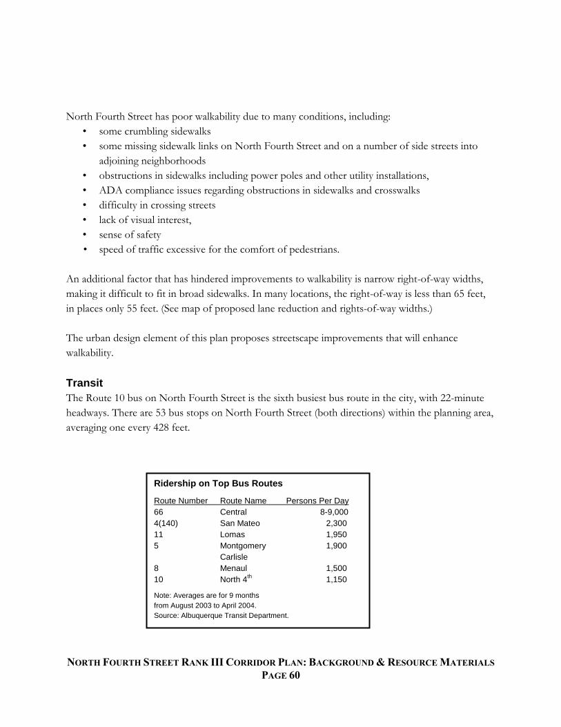
NORTH FOURTH STREET RANK III CORRIDOR PLAN: BACKGROUND & RESOURCE MATERIALS
PAGE 60
North Fourth Street has poor walkability due to many conditions, including:
• some crumbling sidewalks
• some missing sidewalk links on North Fourth Street and on a number of side streets into
adjoining neighborhoods
• obstructions in sidewalks including power poles and other utility installations,
• ADA compliance issues regarding obstructions in sidewalks and crosswalks
• difficulty in crossing streets
• lack of visual interest,
• sense of safety
• speed of traffic excessive for the comfort of pedestrians.
An additional factor that has hindered improvements to walkability is narrow right-of-way widths,
making it difficult to fit in broad sidewalks. In many locations, the right-of-way is less than 65 feet,
in places only 55 feet. (See map of proposed lane reduction and rights-of-way widths.)
The urban design element of this plan proposes streetscape improvements that will enhance
walkability.
Transit
The Route 10 bus on North Fourth Street is the sixth busiest bus route in the city, with 22-minute
headways. There are 53 bus stops on North Fourth Street (both directions) within the planning area,
averaging one every 428 feet.
Ridership on Top Bus Routes
Route Number Route Name Persons Per Day
66 Central 8-9,000
4(140) San Mateo 2,300
11 Lomas 1,950
5 Montgomery 1,900
Carlisle
8 Menaul 1,500
10 North 4th
1,150
Note: Averages are for 9 months
from August 2003 to April 2004.
Source: Albuquerque Transit Department.

NORTH FOURTH STREET RANK III CORRIDOR PLAN: BACKGROUND & RESOURCE MATERIALS
PAGE 61
North Fourth Street is designated in the City Comprehensive Plan and the Metropolitan
Transportation Plan as a Major Transit Corridor. The Comprehensive Plan indicates that high
capacity transit service is possible in the future in the following types of rail or rapid bus.
High capacity urban rail transit includes:
•. Light rail (modern streetcar electrically powered)
• Monorail (on single rail, beam or tube).
High capacity bus transit includes:
• Bus rapid transit (frequent, fast service in separate traffic lane)
• Express bus (for commuters, with limited number of stops).
Densities and transit-oriented mixes of activities are needed to support better transit. Local bus
service on North Fourth Street with headways of 10 minutes or less will require higher bus ridership
generated by higher densities and commercial activities. Express bus, RapidRide or bus rapid transit
service on North Fourth Street need to serve a major destination.
Traffic Safety
During the six-year period of 1998-2003 the following crashes occurred on North Fourth Street:
• 26 crashes involving pedestrians
• 19 crashing involving bicycles
• 1,522 crashes involving other vehicles.
A more detailed three-year accident analysis (2002–2004) was conducted for the North Fourth Street
planning area. Accident data were obtained from the NMDOT Traffic Safety Bureau and were
sorted by type and number of crashes. The top four types of accidents that occurred were rear-end
collisions (33%), left turning collisions (18%), right angle collisions (16%), and driveway-related
accidents (11%).
The pie chart below illustrates recent accidents types and percentages.

NORTH FOURTH STREET RANK III CORRIDOR PLAN: BACKGROUND & RESOURCE MATERIALS
PAGE 62
Alleyways
An opportunity exists on North Fourth Street to utilize alleyways for circulation and access to off-
street parking. Currently, many properties have parking located in front of their buildings that is
approached from Fourth Street.

NORTH FOURTH STREET RANK III CORRIDOR PLAN: BACKGROUND & RESOURCE MATERIALS
PAGE 63
By relocating parking access off Fourth Street, curb-cuts can be reduced and sidewalks can be
installed where available room is currently non-existent.

NORTH FOURTH STREET RANK III CORRIDOR PLAN: BACKGROUND & RESOURCE MATERIALS
PAGE 64
The map on the following page depicts existing blocks where continuous alleys occur. Although
appropriate existing blocks are limited in number, additional blocks could become suitable as
redevelopment takes place.

NORTH FOURTH STREET RANK III CORRIDOR PLAN: BACKGROUND & RESOURCE MATERIALS
PAGE 65

NORTH FOURTH STREET RANK III CORRIDOR PLAN: BACKGROUND & RESOURCE MATERIALS
PAGE 66
Through-Block Connections
Pedestrian through-block connections are public dedications of rights-of-way for a 10-20’ wide
pedestrian and bicycle access way to connect to cul-de-sac streets or other local streets to provide
public paths creating access to schools, parks, shopping centers, transit stops and other destinations.
As North Fourth Street pedestrian-scale shopping areas are improved or developed, opportunities
should be identified for creating these connections.
Trails along Ditches:
Access Opportunities for North Forth Street
The northern portion of the Valley within Albuquerque still retains a rich and significant set of
irrigation laterals, drains and other facilities maintained by the Middle Rio Grand Conservancy
District (MRGCD). These facilities provide both existing and potential opportunities as trails to tie
the North Fourth Street area to other parts of the Valley. A recommended approach to making
better use of the facilities that can make connections to North Fourth Street is:
In general, consider laterals as opportunities for soft-surfaced trails, with trails along drains
more appropriately hard-surfaced. Soft-surfaced trails are appropriate for walking, horses
and some bicycling. Hard-surfaced trails can accommodate more bicycling, particularly for
commuters.
In terms of phasing:
o Improve the capacity of the facilities closest to North Fourth Street to serve local
residents’ needs for trails, i.e., the Alameda Drain and the Harwood, Gallegos and
Chamisal Laterals.
o Work with the MRGCD to improve the ability of other facilities to accommodate
trails, particularly in establishing east-west trails connections through the Valley to
North Fourth Street.

NORTH FOURTH STREET RANK III CORRIDOR PLAN: BACKGROUND & RESOURCE MATERIALS
PAGE 67
Typical Cross-
section of a Hard-
surfaced Trail

NORTH FOURTH STREET RANK III CORRIDOR PLAN: BACKGROUND & RESOURCE MATERIALS
PAGE 68

NORTH FOURTH STREET RANK III CORRIDOR PLAN: BACKGROUND & RESOURCE MATERIALS
PAGE 69
Appendix F. Urban Design
In the June 2006 North Fourth Street Redevelopment Study: Rank III Corridor Plan – Review
Draft, the urban design analysis was approached by dividing the corridor into six sub-areas, or
Character Zones, that have some elements of shared appearance, functionality or other issues.
The Regulatory Plan, Section III of this document, redefined these character zones into three
development districts regulated by a form-based overlay zone. It includes general standards
pertaining to density, intensities, heights, landscaping, signage, parking and lighting as well as
specific form-based standards for building forms and frontage types. Appendix G shows a cost
estimate for making the capital investment in streetscape projects. The following goals and
policies, and landscape standards together with illustrative prototypical designs were contained in
the June 2006 Review Draft.
Goals and Policies for Urban Design
Balance all types of traffic on and near North Fourth Street: pedestrian, bicycle, automobile and
truck for safety, circulation and aesthetics;
Improve multi-modal circulation, safety and accessibility;
Make the street beautiful and exciting to invite both area residents and visitors to shop and play;
Create a streetscape theme(s) for North Fourth Street;
Create opportunities for ―sequential shopping;‖ and
Build flexibility into urban design.
Landscape
For all new development, landscape plant material and associated irrigation shall conform to the
standards outlined in the Albuquerque Code of Ordinances. Applicable sections include (but are
not limited to):
Chapter 6 – Article 1, Part 1: Water Conservation Landscaping and Water Waste
Chapter 6 – Article 6: Trees, Vegetation and Landscaping
Chapter 9 – Article 12: Pollen Control
Chapter 14 – Article 16, Part 3, section 10 (14-16-3-10): Landscaping Regulations
Illustrations of Urban Design Policies and Standards
This section of the June 2006 Review Draft, contains annotated illustrations of urban design
approaches that may be applicable to the redevelopment of North Fourth Street.

NORTH FOURTH STREET RANK III CORRIDOR PLAN: BACKGROUND & RESOURCE MATERIALS
PAGE 70
Character Zone Illustrations
In the June 2006 Review Draft, the study area was divided into “Character Zones.” The zones were
stretches of the study area displaying qualities that differentiate them from the rest of the corridor.
Elements that influenced the Character Zone divisions included the number of residences per zone,
the types of commercial opportunities in the zone, the existence of vacant or underutilized
properties, traffic volumes and circulation issues, and the existence of civic amenities (parks, wide or

NORTH FOURTH STREET RANK III CORRIDOR PLAN: BACKGROUND & RESOURCE MATERIALS
PAGE 71
narrow sidewalks, trails, plazas, etc.) The 2006 draft Corridor report also contained prototypical
design illustrations of typical street cross-sections and street enhancements. These illustrations begin
on the following page.

NORTH FOURTH STREET RANK III CORRIDOR PLAN: BACKGROUND & RESOURCE MATERIALS
PAGE 72

NORTH FOURTH STREET RANK III CORRIDOR PLAN: BACKGROUND & RESOURCE MATERIALS
PAGE 73

NORTH FOURTH STREET RANK III CORRIDOR PLAN: BACKGROUND & RESOURCE MATERIALS
PAGE 74

NORTH FOURTH STREET RANK III CORRIDOR PLAN: BACKGROUND & RESOURCE MATERIALS
PAGE 75

NORTH FOURTH STREET RANK III CORRIDOR PLAN: BACKGROUND & RESOURCE MATERIALS
PAGE 76
“Omitted from Appendix to prevent confusion due to substantial revisions.”

NORTH FOURTH STREET RANK III CORRIDOR PLAN: BACKGROUND & RESOURCE MATERIALS
PAGE 77

NORTH FOURTH STREET RANK III CORRIDOR PLAN: BACKGROUND & RESOURCE MATERIALS
PAGE 78

NORTH FOURTH STREET RANK III CORRIDOR PLAN: BACKGROUND & RESOURCE MATERIALS
PAGE 79

NORTH FOURTH STREET RANK III CORRIDOR PLAN: BACKGROUND & RESOURCE MATERIALS
PAGE 80

NORTH FOURTH STREET RANK III CORRIDOR PLAN: BACKGROUND & RESOURCE MATERIALS
PAGE 81

NORTH FOURTH STREET RANK III CORRIDOR PLAN: BACKGROUND & RESOURCE MATERIALS
PAGE 82

NORTH FOURTH STREET RANK III CORRIDOR PLAN: BACKGROUND & RESOURCE MATERIALS
PAGE 83
Appendix G. Cost Estimate
Cost Estimates for Streetscape Projects
The next pages contain cost estimates developed in 2006 for streetscape projects. The
information is presented by Character Zone and is based on the types of improvements that
would typically occur if this study’s recommendations are followed.
Best Estimate of Costs:
―The following Opinion of Probable Cost is based on the recommended improvements
for each Character Zone in the North Fourth Street study area. Due to the conceptual nature of
the proposed improvements, this cost estimate does not include the repair, relocation, or upgrade
of existing utilities. As recommendations in the North Fourth Street Study become actual
construction projects, proper surveys must be conducted to determine the location and condition
of existing utilities. Additionally, options for the relocation or consolidation of power lines
should be discussed with PNM. All proposed improvements, excluding utilities, are reflected in
the Opinion of Probable Cost.‖
Additional Note: since 2006, project costs have been accelerating at approximately 5% per year.
This rate is subject to change over time, but increases in costs can be anticipated by the time
North Fourth Street design projects can be constructed.

NORTH FOURTH STREET RANK III CORRIDOR PLAN: BACKGROUND & RESOURCE MATERIALS
PAGE 84

NORTH FOURTH STREET RANK III CORRIDOR PLAN: BACKGROUND & RESOURCE MATERIALS
PAGE 85

NORTH FOURTH STREET RANK III CORRIDOR PLAN: BACKGROUND & RESOURCE MATERIALS
PAGE 86

NORTH FOURTH STREET RANK III CORRIDOR PLAN: BACKGROUND & RESOURCE MATERIALS
PAGE 87
Appendix H. Historic Preservation
HISTORIC & ARCHITECTURAL RESOURCES (draft for North Fourth Corridor Plan)
The success of an area often hinges on bringing the past into the present to change the future.
1. INTENT
Numerous commercial and institutional buildings define the historic and architectural character
of the Fourth Street NW corridor within the Plan area. So does the nearby Los Alamos Addition
Historic District, a swath of which is in the Plan area, and which was listed in the State Register
in 2006. The Samuel Shalit House (now Mr. Powdrell’s Barbecue House) was listed in the
National Register in 1984. Several other commercial buildings along the corridor appear to be
eligible for listing. Such listing may improve prospects for their rehabilitation by adding tax
credit potential to rehabilitation financing. Historic registration of eligible buildings with owner
consent is a goal of the Plan.
Retention, adaptive re-use, and rehabilitation of both historic and characteristic buildings are also
goals of the Plan. Retention and rehabilitation can occur whether the buildings remain in original
use or other legal uses. The character of the corridor may be protected and enhanced through
appropriate controls on rehabilitation projects.
2. ARCHITECTURE: FORM & ELEMENTS
Any rehabilitation, remodeling, or addition to a major (public-street-facing) facade of a historic
or characteristic building, as listed below, shall comply with the following:
A. Façade rehabilitation and remodeling shall maintain the original window and door
proportion, and the current percentage, at least, of fenestration on major facades. Where the
original fenestration percentage has been lessened in previous alterations and can be discerned,
the original percentage and configuration should be restored.
B. Any new materials shall be consistent with materials historically employed on such facades,
and original exterior materials on major facades shall be retained or re-exposed to the extent that
those materials are present and visible.
C. Additions to historic and characteristic buildings shall reflect the historic façade demarcations
and proportions.
Where original neon signs or sign bodies remain on commercial buildings, they should be
preserved and adapted, if need be, for use by the current occupant.

NORTH FOURTH STREET RANK III CORRIDOR PLAN: BACKGROUND & RESOURCE MATERIALS
PAGE 88
3. HISTORIC BUILDINGS
For the purposes of this plan, historic building is defined as in the International Existing Building
Code, 2003 Edition, which has been adopted by the City of Albuquerque:
―Any building or structure that is listed in the State or National Register of Historic Places;
designated as a historic property under local or state designation law or survey; certified as a
contributing resource within a National Register listed or locally designated historic district; or
with an opinion or certification that the property is eligible to be listed on the National or State
Register of Historic Places either individually or as a contributing building to a historic district
by the State Historic Preservation Officer or the Keeper of the National Register of Historic
Places.‖
Three buildings in the Plan area meet this definition of historic building:
Samuel Shalit House (Mr. Powdrell’s Barbecue House)
5209 4thStreet NW
Listed, State Register of Cultural Properties (#947)
Listed, National Register of Historic Places
House at 321 Sandia Road NW
Designated ―contributing‖ in the Los Alamos Addition Historic District
District listed, State Register of Cultural Properties (#1893)
House at 313 Placitas Road NW
Designated ―contributing‖ in Los Alamos Addition Historic District
District listed, State Register of Cultural Properties (#1893)
4. CHARACTERISTIC BUILDINGS
―Characteristic‖ refers to certain buildings whose design, history, and state of architectural
integrity make them indicative of a period of history in an area of Albuquerque. Characteristic
buildings may be simply characteristic, but pending further research and subject to owner
consent, some of the characteristic buildings listed below may, in the future, be determined
historic and listed in the National and/or State Register.
The character of 4th Street NW is partly determined by its history as a highway, first New
Mexico Route 1 and later US Highways 66 and 85. It was and is a local arterial street, too, and
much automobile-oriented commercial and residential development occurred along the corridor
during the early and mid-20th century, and this development also helped determine the character
of the street. The following lists of characteristic buildings are organized thematically, under the

NORTH FOURTH STREET RANK III CORRIDOR PLAN: BACKGROUND & RESOURCE MATERIALS
PAGE 89
names of historic contexts recognized by the New Mexico Register of Cultural Properties and
National Register of Historic Places.
Auto-oriented Commercial Development in Albuquerque, 1916-1956
(original property types in parentheses)
1101-1113 4th NW (commercial strip building) Pawn Shop and Garcia’s Kitchen
1217-1225 4th NW (commercial strip building)
1401 4th NW (gas station)
1425 4th NW (commercial strip building) – Harper’s Furs
1601-1629 4th NW (commercial strip building)
1900 4th NW (commercial strip building) – Silver Fox Lounge
1801 4th NW (service garage and dealership) – City Parks & Recreation Department
2222 4th NW (supermarket, 1951) – Roofing Supply of New Mexico
2315 4th NW (commercial strip building) – McComas Restaurant Supply
2413-2417 4th NW (commercial strip building)
2501 4th NW (commercial strip building, 1951)
2601 4th NW (commercial strip buildings)
2513-2515 4th NW (commercial strip building) – Hi-Lo Market etc.
3525 4th NW (commercial strip building, 1951)
3601 4th NW (service garage and dealership)
3717 4th NW (commercial strip building, 1949)
3719 4th NW (commercial strip building, c. 1950)
3926 4th NW (gas station)
4019 4th NW(commercial strip building) – Acequia Books
4120 4th NW (supermarket, 1950) – Samon’s
4200 4th NW (commercial strip center, 1950) – Sensory Plaza
4220 4th NW (gas station)
4500-4522 4th NW (commercial strip buildings)
5565 4th NW (gas station) -- Plateau
5827 4th NW (gas station – remodeled)
6001 4th NW (gas station) – Don Brown’s Auto Service
Historic and Architectural Resources of Route 66 Through New Mexico
(original property type in parentheses)
1420 4th NW (tourist court, 1931)
Twentieth-Century Suburban Growth of Albuquerque, 1904-1959
(original property types in parentheses)
300 Mildred NW -- St. Therese Little Flower Church (suburban church)
201 Menaul NW – Former Stronghurst School (suburban school)

NORTH FOURTH STREET RANK III CORRIDOR PLAN: BACKGROUND & RESOURCE MATERIALS
PAGE 90
Characteristic buildings not yet included in a recognized historic context
(original use in parentheses)
1610 4th NW (Albuquerque National Bank, 1953) -- Consulado de Mexico
5. BENEFITS OF LISTING -- NATIONAL REGISTER OF HISTORIC PLACES
(excerpt from National Park Service website, www.nps.gov)
―The Federal Historic Preservation Tax Incentives program offers a 20% tax credit for the
rehabilitation of income-producing historic structures. Since 1976, the National Park Service has
administered the program in partnership with the Internal Revenue Service and State Historic
Preservation Officers. Tax incentives are one of the nation’s most successful and cost-effective
community revitalization programs having leveraged more than $30 billion in private investment
to rehabilitate historic buildings into rental housing, offices, and retail stores.‖
―Eligibility for certain tax provisions – Owners of properties listed in the National Register are
eligible for a 20% investment tax credit for the certified rehabilitation of income-producing
certified historic structures such as commercial, industrial, or rental residential buildings. The
credit can be combined with a straight-line depreciation period of 27.5 years for residential
property and 31.5 years for non-residential property for the depreciable basis of the building
reduced by the amount of the tax credit claimed. Federal tax deductions are available for
charitable contributions for conservation purposes of partial interests in important land areas or
structures.‖
―Consideration in planning for Federal, federally licensed, and federally assisted projects.
Section 106 of the National Historic Preservation Act of 1966 requires that Federal agencies
allow the Advisory Council on Historic Preservation an opportunity to comment on undertakings
affecting historic properties either listed in or determined eligible for listing in the Register. The
Advisory Council oversees and ensures the consideration of historic places in the Federal
Planning process.‖
―Qualification for Federal grants for historic preservation, when funds are available. Owners of
private property listed in the National Register are free to maintain, manage, or dispose of their
property as they choose provided that no Federal monies are involved.‖
6. BENEFITS OF LISTING -- STATE REGISTER OF CULTURAL PROPERTIES
(from State Historic Preservation Division website, www.nmhistoricpreservation.org)
Created in 1968, the State Register of Cultural Properties recognizes properties that contribute to
New Mexico’s history and cultural traditions. When cultural properties are listed in the State
Register, taxpayer owners become eligible for a State income tax credit for approved restoration,
rehabilitation, or preservation and may request technical assistance from the State Historic
Preservation Division. Listing in the State Register also provides protection against adverse
public use (see Section 18-8-7 NMSA 1978).

NORTH FOURTH STREET RANK III CORRIDOR PLAN: BACKGROUND & RESOURCE MATERIALS
PAGE 91

NORTH FOURTH STREET RANK III CORRIDOR PLAN: BACKGROUND & RESOURCE MATERIALS
PAGE 92

NORTH FOURTH STREET RANK III CORRIDOR PLAN: BACKGROUND & RESOURCE MATERIALS
PAGE 93

NORTH FOURTH STREET RANK III CORRIDOR PLAN: BACKGROUND & RESOURCE MATERIALS
PAGE 94

NORTH FOURTH STREET RANK III CORRIDOR PLAN: BACKGROUND & RESOURCE MATERIALS
PAGE 95

NORTH FOURTH STREET RANK III CORRIDOR PLAN: BACKGROUND & RESOURCE MATERIALS
PAGE 96

NORTH FOURTH STREET RANK III CORRIDOR PLAN: BACKGROUND & RESOURCE MATERIALS
PAGE 97

NORTH FOURTH STREET RANK III CORRIDOR PLAN: BACKGROUND & RESOURCE MATERIALS
PAGE 98

NORTH FOURTH STREET RANK III CORRIDOR PLAN: BACKGROUND & RESOURCE MATERIALS
PAGE 99

NORTH FOURTH STREET RANK III CORRIDOR PLAN: BACKGROUND & RESOURCE MATERIALS
PAGE 100


![Clarinet in B Trio voor Klarinet , Altviool en piano files/Chamber/[Clarinet_Institute] Ostijn... · misty misty misty misty 3 3 Trio voor Klarinet , Altviool en piano Willy Ostyn](https://static.fdocuments.net/doc/165x107/5ac4c16d7f8b9af91c8d36c3/clarinet-in-b-trio-voor-klarinet-altviool-en-clarinetinstitute-ostijnmisty.jpg)