Missisquoi Bay Causeway Scoping Report -...
37
Missisquoi Bay Causeway Scoping Report Vermont Agency of Transportation Policy, Planning, and Intermodal Development Division One National Life Drive Montpelier, VT 05633‐5001 802‐828‐2784 www.vtrans.vermont.gov September 30 2016 DRAFT
Transcript of Missisquoi Bay Causeway Scoping Report -...

Missisquoi Bay Causeway
Scoping Report
Vermont Agency of Transportation
Policy, Planning, and Intermodal Development Division
One National Life Drive
Montpelier, VT 05633‐5001
802‐828‐2784
www.vtrans.vermont.gov
September 30 2016
DRAFT

Missisquoi Bay Causeway Scoping Study – Draft September 30, 2016
VTrans Policy and Planning Page i
TABLE OF CONTENTS
EXECUTIVE SUMMARY ..................................................................................... ES‐1
1.0 INTRODUCTION ......................................................................................... 1
2.0 BACKGROUND AND CONTEXT ........................................................................ 1 2.1 Causeway History and General Characteristics ........................................................................................ 1
2.2 Federal Earmarks Related to the Missisquoi Bay Bridge and Causeway .................................................. 3
2.3 Water Quality ........................................................................................................................................... 5
2.4 Spiny Softshell Turtle ............................................................................................................................... 8
3.0 PROJECT PURPOSE AND NEED ..................................................................... 12
4.0 ALTERNATIVES ANALYSIS ........................................................................... 13 4.1 Cost Estimate Approach ......................................................................................................................... 14
4.2 Permit Requirements ............................................................................................................................. 14
4.3 Alternatives ............................................................................................................................................ 18
5.0 PREFERRED ALTERNATIVE .......................................................................... 26
REFERENCES ..................................................................................................... 28
ATTACHMENT A: CAUSEWAY REMOVAL PLANS FROM MISSISQUOI BAY BRIDGE PROJECT .... 29
ATTACHMENT B: COST ESTIMATES ........................................................................ 30
List of Figures
Figure 1: Regional Location .................................................................................................................... 2
Figure 2: Causeway Site ......................................................................................................................... 3
Figure 3: Other Vermont Bridges Funded by Earmarks 2005 SAFETEA‐LU Earmark ............................. 4
Figure 4: Missisquoi Bay Phosphorus Concentrations ........................................................................... 5
Figure 5: Northeast Arm Phosphorus Concentrations2 ......................................................................... 5
Figure 6: Implementation Schedule for Phased Removal of the Eastern Arm .................................... 21
Figure 7: Evaluation Matrix .................................................................................................................. 25

Missisquoi Bay Causeway Scoping Study – Draft September 30, 2016
VTrans Policy and Planning ES‐1
EXECUTIVE SUMMARY
This report evaluates alternatives to remove the causeway at the southern end of Lake
Champlain’s Missisquoi Bay. The study was requested by the Vermont Legislature in Act 40 of
2015. The causeway, and drawbridge that once spanned its opening, formerly carried VT Route
78 across the mouth of the Bay. The drawbridge was removed but most of the causeway was
left in place following the construction of a new shore‐to‐shore bridge in 2007. There is
approximately $4.12 million remaining in the federal earmark that was used to fund the
Missisquoi Bay bridge project. The $4.12 million earmark must be matched with 20% non‐
federal funds. While the Missisquoi Bay bridge project is complete, VTrans must decide whether
or not the funds remaining from the earmark should be used to remove more of the causeway
or be repurposed for investment in other transportation system programming. This report
informs that decision. VTrans is seeking public input on this draft and will document comments
in a final report.
The purpose of this project is to help improve water quality in the Missisquoi Bay without
causing an unacceptable increase to the phosphorus concertation in the Northeast Arm of Lake
Champlain (see Figure 1), and without causing an unacceptable impact to the spiny softshell
turtles, a state designated threatened species that depend on the causeway and surrounding
lake for habitat.
Four alternatives are evaluated including (1) leave the causeway in place, (2) remove a portion
of the eastern arm of the causeway, (3) remove all of the eastern arm of the causeway and (4)
complete removal of the eastern and western arms of the causeway.
The selection of a preferred alternative is constrained by the available funding of $4.12 million
and the need for action must consider the following points:
Phosphorus concentrations exceed the Vermont water quality standards in most areas of
Lake Champlain today and have been since the 1980s. The current phosphorous
concentration in the Missisquoi Bay and the Northeast Arm exceed the water quality
standards. Phosphorus sources in Missisquoi Bay and their relative contributions include
streambank erosion (35%), and stormwater runoff from cropland (29%), forest (16%),
developed land (9%) and backroads (5%). The 6% balance is from farmstead, pastureland
and wastewater facilities.
Many residents believe that removal of the causeway will significantly improve water quality
in the Missisquoi Bay by restoring a more effective flushing of phosphorus to the south
where it can mix with waters in the Northeast Arm.
Removal of the eastern and western arms of the causeway has been estimated to reduce
bay‐wide average phosphorus concentrations and sedimentation in Missisquoi Bay by about
1 %. Any changes in currents or phosphorus levels would be limited to the vicinity of the
causeway (within about two miles), and would be matched by corresponding phosphorus
increases south of the causeway in the Northeast Arm.
The potential effect of the causeway on phosphorus concentration were evaluated
extensively as part of the scoping and permitting process for the Missisquoi Bay bridge
project. The science and methodology were peer reviewed and vetted through a public

September 30, 2016 Missisquoi Bay Causeway Scoping Study – Internal Review Draft
ES‐2 VTrans Policy & Planning
process led by the US‐Canada International Joint Committee (IJC) and found to be sound.
However, local public sentiment remained strongly in favor of causeway removal as a water
quality mitigation measure. In recognition of this local sediment, the IJC recommended
removing the causeway because it was an obstacle to cooperative efforts to address water
quality. The local sentiment is also supported by the 2015‐2023 Northwest Regional Plan
which includes a policy to remove the causeway as a strategy to improve water quality.
The Missisquoi Bay causeway provides habitat for the spiny softshell turtle which is included
on the state’s list of endangered and threatened species. The turtles use a narrow band of
the causeway at waterline for a basking area during the fall, and use the lake bottom north
and south of the causeway opening for winter hibernation.
The monitoring program conducted as part of the bridge project found that spiny softshell
turtles continue to use the causeway and bridge area for basking and winter hibernating.
The monitoring report also notes that longer term impacts due to permanent habitat
changes resulting from the bridge project and partial causeway removal are uncertain.
Therefore, removal of any additional sections of the causeway must proceed with caution
and include appropriate monitoring and mitigation.
VTrans, after consulting with the Vermont Agency of Natural Resources, recommends
Alternative 2 ‐ Partial Removal of the Eastern Arm of the causeway. This alternative would
remove approximately 330 feet of the causeway, the maximum possible given permitting and
funding constraints. Alternative 2 satisfies the purpose and need to improve water quality in the
Missisquoi Bay without causing a significant increase of phosphorus in the Northeast Arm and
while minimizing impacts to the spiny softshell turtles. Partial removal is a step towards
satisfying the policy in the Northwest Regional Plan and recommendation of the IJC, both of
which call for causeway removal. It is the only removal alternative that can be implemented for
an estimated cost ($2.4 million) that does not exceed the remaining funds from the Missisquoi
Bay Bridge earmark ($4.1 million). This cost estimate includes engineering, permitting,
construction and turtle and water quality monitoring. Results from monitoring impacts to the
spiny softshell turtle and water quality would be permit conditions for this alternative and
would also inform a future assessment about removing additional sections of the causeway.
Alternative 1 ‐ Leave the Causeway in Place would allow the earmarked funds to be redirected
to other federally eligible transportation projects. However, Alternative 1 is not recommended
because it has a neutral effect on water quality and is not supported by the Northwest Regional
Plan.
The other two causeway removal alternatives are not permittable at this time, would take
decades to implement and their estimated costs exceed available funding. Removal of the entire
eastern arm (Alternative 3) would have to be implemented in four phases that could extend
over thirty years and have an estimated cost of $8.9 million. The cost to remove the entire
eastern and western arms (Alternative 4) would also take more than thirty years, and could cost
in excess of $13.5 million. Alternative 4 could only be implemented if the spiny softshell turtles
were relocated, which is not included in the cost estimate. Successful relocation is extremely
unlikely and the cost and timeline associated with such an effort would be significant.
Missisquoi Bay Causeway Scoping Study – Draft September 30, 2016
VTrans Policy and Planning Page 1 of 33
1.0 INTRODUCTION
This scoping report evaluates alternatives to remove the former VT Route 78 causeway at the
southern end of Lake Champlain’s Missisquoi Bay. The study was requested by the Vermont
Legislature in Act 40 of 2015.1 The causeway, and drawbridge that once spanned its opening,
formerly carried VT Route 78 across the mouth of the Bay. The drawbridge was removed but
most of the causeway was left in place following the construction of a new shore‐to‐shore
bridge in 2007. There is approximately $4.12 million left in the federal earmark that was used to
fund the Missisquoi Bay bridge project. The $4.12 million earmark must be matched with 20%
non‐federal funds. While the Missisquoi Bay bridge project is complete, VTrans must decide
whether or not the funds remaining from the earmark should be used to remove more of the
causeway or be repurposed for investment in other transportation system programming. This
report informs that decision. VTrans is seeking public input on this draft and will document
comments in a final report.
Section 2.0 provides background information on the causeway and why it was left in place
following the bridge project. The decision to leave most of the causeway in place considered
complex and competing issues related to its potential effect on the Bay’s water quality and its
use as wildlife habitat for the spiny softshell turtle, a threatened species. A summary of each
issue is provided because they continue to be determining factors on the desirability, feasibility,
and cost effectiveness of removing some or all of the causeway.
Section 3.0 describes the project’s purpose and need based on the findings from Section 2.0.
Section 4.0 evaluates four alternatives including (1) leave the causeway in place, (2) remove a
portion of the eastern arm of the causeway, (3) remove all of the eastern arm of the causeway
and (4) complete removal of the eastern and western arms of the causeway. Order of
magnitude cost estimates, potential resource impacts and permitting requirements are
identified for each alternative. Advantages and disadvantages are summarized.
Section 5.0 summarizes findings and presents the VTrans recommended alternative.
The information presented in this report is based on a review of various permits issued for the
Missisquoi Bay Bridge Project, the spiny softshell turtle Monitoring Report and consultation with
VTrans and Agency of Natural Resource staff that were involved with the bridge project or are
subject matter experts.
2.0 BACKGROUND AND CONTEXT
2.1 Causeway History and General Characteristics
The Missisquoi Bay Causeway extends on an east‐west alignment across the southern end of
Lake Champlain’s Missisquoi Bay. The causeway and the old Missisquoi Bay Bridge were
1 No. 40. 2015. An act relating to the State’s Transportation Program and miscellaneous changes to laws related to transportation., Sec. 22. State Highway Bridge program

September 30, 2016 Missisquoi Bay Causeway Scoping Study – Draft
Page 2 of 33 VTrans Policy & Planning
constructed circa 1938 to carry VT Route 78 across the mouth of the Bay. VT 78 provides an
east‐west connection between I‐89 and US 7 in Swanton, VT and US 2 in Alburgh, VT which
further extends into New York State via the Rouses Point Bridge. VT 78 is on the National
Highway System (NHS) and connects Interstate 87 in New York State and Interstate 89 in
Vermont (Figure 1).
Figure 1: Regional Location
The old drawbridge spanned an opening of approximately 500 feet between the eastern and
western arms of the causeway. The old opening was divided into three channels by concrete
bridge piers. A new multi‐span bridge, with much shorter causeways at its approaches from
each shoreline was constructed over three years and opened to traffic in 2007. The new bridge
is located approximately 60 feet on‐center to the south of the causeway and old bridge. After
the completion of the new bridge, the causeway no longer served a transportation purpose. The
drawbridge was removed, and the waterway opening was increased from approximately 500
feet to 830 feet. The larger opening was created by removing 330 feet of the eastern arm of the
causeway. An aerial view of the existing causeway, new bridge and surrounding area is shown in
Figure 2.
The eastern arm of the causeway is open to the public for recreational purposes and is served by
a parking lot and boat launch at the Larry Greene Fishing Access that is maintained and operated

Missisquoi Bay Causeway Scoping Study – Draft September 30, 2016
VTrans Policy and Planning Page 3 of 33
by the Vermont Department of Fish & Wildlife. As required in the Endangered and Threatened
Species Taking Permit for the bridge project, the western arm of the causeway is closed to the
public to protect its use as a basking area for the spiny softshell turtle, which are discussed
further in Section 2.4 of the report. The top of both arms of the causeway is approximately 28
feet wide and is approximately 20 feet above the lake bottom at the terminal end of the eastern
arm. The causeway is approximately 100 feet wide at the lake bottom. The causeway extends an
unknown distance below the bottom of the lake. The top surface of the causeway is
predominantly asphalt over a gravel roadway base. The structure of the causeway consists of
larger sized rock and rip rap mined from a nearby quarry when the causeway was constructed in
1938. Attachment A includes sheets from the bridge construction plans that show the section of
the eastern arm that was removed.
Figure 2: Causeway Site
2.2 Federal Earmarks Related to the Missisquoi Bay Bridge and Causeway
An earmark for the new Missisquoi Bay Bridge was provided in the 2005 federal funding and
authorization bill referred to as SAFETEA‐LU1, and was modified in the SAFETEA‐LU Technical
Corrections Act of 2008. The original 2005 earmark set aside $18,000,000 for the replacement of
the Missisquoi Bay Bridge. It also set aside $32,000,000 for nine other state‐maintained bridges
1 Safe, Accountable, Flexible, Efficient Transportation Equity Act: A Legacy for Users

September 30, 2016 Missisquoi Bay Causeway Scoping Study – Draft
Page 4 of 33 VTrans Policy & Planning
in Vermont (Figure 3). The 2008 SAFETEA‐LU Corrections Act modified the earmark language to
allow the $18,000,000 for the replacement of the Missisquoi Bay Bridge and the removal of the
Missisquoi Bay causeway and also added the following special conditions:
Requires VTrans to certify “…to the Federal Highway Administration the final
determination of the agency regarding the removal of the Missisquoi Bay causeway.”
Allows VTrans to use any unobligated or unexpended funds remaining from the
Missisquoi Bay Bridge earmark for replacement and reconstruction of the nine other
State‐maintained bridges identified in the 2005 earmark after VTrans makes a
determination regarding removal of the causeway.
As of March 2016, there was approximately $4.12 million of unobligated and unexpended
federal funds remaining from the Missisquoi Bay Bridge earmark. The special conditions added
to the earmark language in 2008 require that any funds not used to replace the Missisquoi Bay
Bridge or to remove the causeway may only be spent on the other nine state‐maintained
bridges. However, as indicated in (Figure 3), all of these other bridges are either complete or
nearly complete and do not require any additional funds.
The latest and recently passed 2015 federal transportation reauthorization law (FAST Act), now
allows any unobligated earmark funds to be utilized for other transportation projects within 50
miles from the location of the project for which the earmark funds were originally intended. The
redirected earmark funds must be used for a transportation project that is eligible for federal
funding. Once a state elects to repurpose funds, it will have until the end of FY 2019 to obligate
the funds. Earmark funds that are not repurposed will be lost.
Figure 3: Other Vermont Bridges Funded by Earmarks 2005 SAFETEA‐LU Earmark
Municipality Bridge Set Aside Status
Reading BR#1‐VT 44 $2.1 M Complete and accepted May 2008
Huntington BR#42‐East St $2.5 M Complete and accepted Sep 2008
Tunbridge BR#4‐VT 110 $4.5 M Complete and accepted Sep 2008
Bethel BR#31‐VT 12 (Church St) $3.9 M Complete and accepted Oct 2008
Springfield BR#64‐VT 11 (Main St) $1.0 M Complete and accepted Sep 2010
Stockbridge BR#30‐VT 100 $3.0 M Complete and accepted Oct 2010
Cornwall BR#9‐VT 125 $4.0 M Complete and accepted Nov 2011
Bristol BR#8‐VT 116 $6.0 M Substantially complete June 2015
Rutland City BR#2‐River St $5.0 M Under construction. Anticipated Completion 2017
Construction Season
Total $32.0 M

Missisquoi Bay Causeway Scoping Study – Draft September 30, 2016
VTrans Policy and Planning Page 5 of 33
2.3 Water Quality
Phosphorus concentrations exceed the Vermont water quality standards in most areas of the
Lake today and have been since the 1980s. The current phosphorous concentration in the
Missisquoi Bay is about twice as high as the water quality standards for that segment of the lake
(0.025 micrograms/liter) and is on an increasing trend line (Figure 4). South of the causeway,
phosphorous concentration in the Northeast Arm of Lake Champlain also consistently exceed
the water quality standards for that segment of the lake (0.014 micrograms/liter) and continues
to increase (Figure 5). Based on modeling conducted by the EPA, agricultural land, developed
land and streambank erosion are the major sources of phosphorus for all segments of the Lake.
Phosphorus sources in Missisquoi Bay and their relative contributions include streambank
erosion (35%), and stormwater runoff from cropland (29%), forest (16%), developed land (9%)
and backroads (5%). The 6% balance is from farmstead, pastureland and wastewater facilities1.
Figure 4: Missisquoi Bay Phosphorus Concentrations2
Figure 5: Northeast Arm Phosphorus Concentrations4
1 “Lake Champlain Phosphorus TMDL Phase 1Implementation Plan”; Forwarded by the State of Vermont for the U.S. Environmental
Protection Agency; Draft August 2015; Figure 3, Page 17
2 “Phosphorus TMDLs for Vermont Segments of Lake Champlain”, U.S. Environmental Protection Agency; Region 1, New England; Boston, MA; August 14, 2015; Figure 5, Page 15.

September 30, 2016 Missisquoi Bay Causeway Scoping Study – Draft
Page 6 of 33 VTrans Policy & Planning
Poor water quality in the Missisquoi Bay has been a driving factor in the public’s desire to
remove the causeway. Many residents believe that removal of the causeway will significantly
improve water quality in the Missisquoi Bay by restoring a more effective flushing of phosphorus
to the south where it can mix with waters in the Northeast Arm. Therefore, there was a need to
evaluate whether or not causeway removal would be an effective strategy to improve water
quality in Missisquoi Bay without causing an unacceptable increase to the phosphorus in the
Northeast Arm.
VTrans recognized the need to repair or replace the old Missisquoi Bay Bridge more or less
coincident with the public’s increasing desire to remove the causeway as a means to improve
water quality in the Bay. The early bridge alternatives included rehabilitating or reconstructing
the old drawbridge which would leave the causeway intact, and constructing a new shore‐to‐
shore bridge on a new alignment. A new shore‐to‐shore bridge would have eliminated the need
for the causeway from a transportation perspective and created the possibility that it could be
removed. Therefore, there was a need for VTrans to evaluate the water quality benefits of
causeway removal.
To help advise the Vermont Agency of Transportation and inform the general public, the ANR
Water Quality Division conducted a phosphorus mass balance modeling analysis of Missisquoi
Bay which simulated the enhanced mixing effects of causeway removal. An initial report was
prepared in 1993 and refined and updated in 1994.
The results of the 1993‐1994 Water Quality Division modeling study1,2 suggested that removal of
the causeway would produce an 8% reduction in average total phosphorus concentrations in
Missisquoi Bay, and a 9% increase in phosphorus concentrations in the Northeast Arm. Based on
information provided by engineering consultants to the Vermont Agency of Transportation, the
estimated additional project cost of removing the causeway and building a shore‐to‐shore
bridge was $21 million3, relative to the cost of the simpler design alternative under
consideration at the time which would have kept the highway on the existing causeway.
Because the water quality benefits to Missisquoi Bay would be offset by adverse impacts on the
Northeast Arm with no net phosphorus removal benefit to Lake Champlain as a whole, and
because of the poor cost/benefit ratio, the report concluded that causeway removal was not
justified by water quality considerations.
Presentation of the findings of the Water Quality Division study generated a strong negative
public reaction in which a desire for an additional study was expressed. The Agency of
Transportation agreed to fund a second analysis that would address public desire for a study
that (1) was conducted by a scientific consultant independent of state government, (2)
developed a true hydrodynamic model that directly simulated changes in water currents in the
1 Vermont Agency of Natural Resources. 1993. Vermont Route 78 Swanton‐Alburg Bridge Project water quality assessment. The
effects of a wider bridge opening on water quality in Missisquoi Bay and the Northeast Arm of Lake Champlain. Waterbury, VT.
2 Vermont Agency of Natural Resources. 1994. Vermont Route 78 Swanton‐Alburg Bridge Project water quality assessment. Update. Waterbury, VT.
3 It should be noted that later in the design process, the Agency of Transportation determined that construction of a new shore‐to‐
shore bridge was the preferred alternative due to geotechnical reasons independent of water quality considerations. This decision removed the major cost of building a new bridge from the with vs. without causeway cost comparison.

Missisquoi Bay Causeway Scoping Study – Draft September 30, 2016
VTrans Policy and Planning Page 7 of 33
bay in response to causeway removal, and (3) modeled sedimentation changes in the bay as
well as phosphorus concentrations.
The scientific studies were conducted by Applied Science Associates, Inc. (ASA) and were
overseen by the ANR in consultation with an international Project Advisory Committee
composed of federal, provincial, and state water quality and engineering experts, as well as local
elected officials and other citizens. The work involved field data collection and modeling
analyses to simulate the impacts of causeway removal. In two reports released in 1997, ASA
concluded that removal of the causeway would reduce bay‐wide average phosphorus
concentrations and sedimentation in Missisquoi Bay by about 1 %. Any changes in currents or
phosphorus levels would be limited to the vicinity of the causeway (within about two miles), and
would be matched by corresponding phosphorus increases south of the causeway in the
Northeast Arm portion of Lake Champlain. After reviewing these reports, the Agency of Natural
Resources and the Project Advisory Committee found that the conclusions were valid and
should be used as part of the public decision regarding causeway removal.
In spite of these findings, local public sentiment remained strong in favor of causeway removal
as a water quality mitigation measure. In response, the U.S. and Canadian federal governments
requested in 2004 that the International Joint Commission (IJC)1 investigate the matter and
consider whether the causeway's continued existence was consistent with the Boundary Waters
Treaty between the two countries.
The IJC established an International Missisquoi Bay Task Force to advise them, and the Task
Force oversaw a scientific peer review of the ASA modeling studies. The peer review was
conducted by eight scientists from various federal, state, and provincial environmental
management agencies. After considering the results of the scientific peer review, the Task Force
reported to the IJC that the hydrodynamic modeling studies were scientifically sound and very
likely to be correct, and that the IJC should rely on these findings. The Task Force concluded that
neither the existing causeway nor its removal would affect flows or pollution in either the U.S.
or Canada beyond very small amounts in areas in the near vicinity of the causeway.
The IJC issued its report to the United States and Canadian federal governments in 2005. The IJC
accepted the Task Force findings and concluded that the causeway did not affect water levels or
flows or cause more than negligible pollution in Missisquoi Bay. The IJC did, however,
recommend that the causeway be removed, with two significant conditions, in order to help
refocus public attention on necessary phosphorus reductions from the bay's watershed and to
remove what they described as "an obstacle to expanding the cooperative efforts by farmers,
municipalities, taxpayers and others that will be needed to achieve nutrient reductions." The
IJC’s recommendation was made with the condition that an amount of money equal to the cost
of causeway removal paid for by the State of Vermont be provided by the governments of
Canada and Quebec to be spent roughly equally on both sides of the international boundary to
(1) reduce phosphorous inputs into the bay and (2) to facilitate the relocation of the habitat for
the spiny softshell turtles.
1 The International Joint Commission (IJC) is established by the Boundary Waters Treaty to hear disputes under certain
circumstances when requested by the United State and Canadian governments. If the IJC decides to hear a dispute, it renders a
non‐binding report. The Boundary Waters Treaty, signed in 1909, provides principles and mechanisms to help resolve disputes concerning water quality and water quantity along the boundary between the United States and Canada.
September 30, 2016 Missisquoi Bay Causeway Scoping Study – Draft
Page 8 of 33 VTrans Policy & Planning
The IJC recommendation to remove the causeway is conditioned on relocating the habitat for
the spiny softshell turtle. The IJC expressed its shared concern with the future of the turtles but
was convinced that with appropriate study, planning and action, adequate habitat for the turtles
could be found or established.
Subsequent lake monitoring and research has corroborated the 1997 ASA water quality
modeling findings:
After a portion of the causeway was removed in 2007 as part of the construction of the
new Missisquoi Bay bridge, the ANR Department of Environmental Conservation
examined long‐term water quality monitoring data obtained before (1992‐2006) and
after (2007‐2011) the partial causeway removal. No changes in water quality gradients
between Missisquoi Bay and the Northeast Arm were found to suggest that no
enhanced water mixing between these two areas of Lake Champlain had occurred after
partial causeway removal.
Sediment core studies conducted by researchers at the University of Vermont and
published in 2012 in the Journal of Great Lakes Research examined the history of water
quality changes in northeastern Lake Champlain. This research found no alteration of
the eutrophication rate in Missisquoi Bay following causeway construction in 1937.
According to this paper, algal blooms in Missisquoi Bay did not develop until decades
later, concurrent with the intensification of regional agriculture in the 1970s.
Local public opinion continues to support causeway removal as a means to improve water
quality in Missisquoi Bay. This opinion is articulated in the Northwest Regional Plan which
“…support(s) removal of the Missisquoi Bay and Carry Bay causeways” as a policy to support
Goal 3 to maintain or improve the quality of lakes, ponds, rivers, streams and groundwater1
2.4 Spiny Softshell Turtle
The Missisquoi Bay Causeway provides habitat for the spiny softshell turtle which is included on
the state’s list of endangered and threatened species. The turtles use a narrow band of the
causeway at waterline for a basking area during the fall, and use the lake bottom north and
south of the causeway opening for winter hibernation (hibernaculum). The impact on the spiny
softshell turtle is a significant consideration when evaluating the feasibility of different
causeway removal alternatives. This section describes the requirements of the Endangered and
Threatened Species Taking Permit and some of the related characteristics of the spiny softshell
turtle to inform the alternatives evaluation in Section 4.0.
Endangered and Threatened Species Taking Permit
Per Vermont’s Endangered and Threatened Species Act, a permit is required to justify the taking
or possession of an endangered or threatened species. The spiny softshell turtle is listed as a
threatened species. The permitting requirements are the same for endangered and threatened
species.
1 Page 85, Plan for the Northwest Region, 2015‐2023, Adopted July 29, 2015, Northwest Regional Planning Commission
Missisquoi Bay Causeway Scoping Study – Draft September 30, 2016
VTrans Policy and Planning Page 9 of 33
Prior to 2016, an Endangered and Threatened Species Taking Permit (E&T Permit) could be
issued if the Secretary of ANR determined that the taking is being done for scientific purposes;
to enhance the propagation of species; to prevent or mitigate economic hardship; for zoological
exhibition; for educational purposes, and for special provisions consistent with the federal
Endangered Species Act (10 VAS §5408(a)). Act 145 of 2016 modified the Endangered and
Threatened Species Act in two ways relative to the causeway. First, it allows the Secretary of
ANR to designate by rule critical habitat for endangered and threatened species. Second, it
eliminated economic hardship as a basis for a taking and added “incidental taking”. The criteria
for allowing an incidental taking are: 1) the taking is necessary to conduct an otherwise lawful
activity; (2) the taking is attendant or secondary to, and not the purpose of, the lawful activity;
(3) the impact of the permitted incidental take is minimized; and (4) the incidental taking will
not impair the conservation or recovery of any endangered species or threatened species.
The original E&T Permit application submitted by VTrans was based on the construction of a
new shore‐to‐shore bridge located 60 feet south of the existing road and causeway, removal of
the old drawbridge and removal of most of the eastern and western arms of the causeway.
Construction of a new bridge and complete removal of the drawbridge and causeway was the
preferred alternative recommended in the 1997 Environmental Assessment completed to satisfy
NEPA requirements.
Public input was provided during the E&T Permit hearing process by local officials from Vermont
and Canada, the Northwest VT Regional Planning Commission, Lake Champlain Committee, Lake
Champlain Walleye Association, Audubon Vermont, and the Conservation Law Foundation. As
required in state statute, the Endangered Species Committee also provided advice for the
Secretary’s consideration. Comments were offered in support and in opposition to complete
causeway removal.
The Endangered Species Committee advised that the new bridge be placed north of the
causeway, rather than south where it may shade the turtle’s basking area along the causeway.
The Committee also recommended that if the permit allows, removal should be limited to only a
portion of the eastern arm. The Endangered Species Committee also advised that any additional
removal should not occur until monitoring for a five‐year period establishes that the project has
not caused unacceptable impacts to the turtle population. Incremental removal at five‐year
intervals would allow assessment of the impact of the construction and flow dynamics changes
to turtle habitat.
An E&T Takings Permit was issued in January 2002. It allowed construction of the new bridge
south of the causeway as proposed by VTrans and complete removal of the old drawbridge
including its piers and abutments. The permit limited removal of the causeway to 330 feet on
the lake end of the eastern arm. The species of concern addressed in the permit were the spiny
softshell turtle, and three different types of mussels. The permit includes some conditions
related to the mussels. The mussels are not expected to have a significant impact on alternatives
to remove more sections of the causeway. However, if state listed mussels are found in a
construction zone, there are typically relocation and monitoring conditions in the E&T permit.
The findings and conclusions on which the E&T Permit is based document the impact that
causeway removal, and other aspects of the bridge project, would have on the turtle’s basking
area and hibernacula and justified the taking based on the public benefits of the bridge project.

September 30, 2016 Missisquoi Bay Causeway Scoping Study – Draft
Page 10 of 33 VTrans Policy & Planning
The impacts are due primarily to removal of the causeway while the benefits are all related to
transportation improvements resulting from the new bridge. Conclusion #16 of the E&T Permit
describes the nexus between causeway removal and the new bridge:
The construction of the new bridge and removal of the old bridge are integral parts of
one application due to the 404 requirement imposed by the US Army Core of Engineers
that fill be removed from Lake Champlain in an amount equal to what is put into the
lake (to accommodate the fill required for the new piers and approaches of the new
bridge).
The justification for issuing the E&T Permit is based on the consequences described in
conclusions number 21‐25 which state that failure to approve the Species Taking Permit for the
Bridge would:
Result in an unwarranted privation on the orderly development of the State;
Impose an economic hardship on the State by continuing the traffic delays caused by
the present bridge’s narrowness;
Impose an economic hardship on the State by continuing the public safety expenses
caused by the present bridge’s narrowness;
Impose an economic hardship on the State by continuing the unnecessary maintenance
expenses caused by the present bridge’s age and deteriorating condition; and
Impose an economic hardship on the State by facilitating the $5,517,600 civil penalty
that the United States Coast Guard can levy on VTrans (because the old bridge was
restricting navigation).
A new E&T Permit will be required before more sections of the causeway can be removed to
justify taking of the spiny softshell turtle. Removal of some or all the remaining causeway would
be a stand‐alone project that is no longer linked to the bridge project and the benefits it
provides. Therefore, the taking must be justified based on conditions specific to the causeway
related to the exceptions in Vermont’s Endangered and Threatened Species Act described
above.
The most relevant of these exceptions are the incidental taking justifications added in 2016 in
Act 145 as described above. Additionally, Vermont’s Endangered and Threatened Species Act
requires that an applicant demonstrate that a proposed activity cannot practicably be designed
to avoid the taking and still satisfy the basic project purpose. If the purpose of causeway
removal is to improve water quality, particularly to reduce phosphorus, there are a number of
alternative approaches available that will not directly impact the turtles.
Other conclusions in the E&T Permit that are important to consider:
#17 ‐ There are two habitat features associated with the Missisquoi Bay Bridge that are
important to the spiny softshell turtles, the basking areas provided by the causeway and
the underwater hibernaculum (adjacent to the causeway) provided by the water flow
and the causeway.
#18 ‐ The turtles make limited use of the eastern causeway for basking

Missisquoi Bay Causeway Scoping Study – Draft September 30, 2016
VTrans Policy and Planning Page 11 of 33
#19 ‐ The change in flow mechanics caused by the removal of the causeway will have an
adverse impact on the hibernaculum. The adverse effect will be a result of decreased
flow velocity and changes in benthic (lake bottom) erosion. The greater amount of the
causeway removed, the greater impact on the hibernaculum.
The permit includes fifteen conditions specific to the spiny softshell turtles. Most of the permit
conditions addressed issues related to reducing impacts during construction and monitoring
requirements. Results of the monitoring are described in more detail below. the following
conditions have the most bearing on alternatives related to removal of additional sections of the
causeway:
Condition 11: This condition originally prohibited any access to the eastern arm of the
causeway. It was later eliminated by a permit amendment and full access is allowed. The
eastern arm of the causeway is now open to the public for recreational purposes and is
served by a parking lot and boat launch at the Larry Greene Fishing Access that is
maintained and operated by the Vermont Department of Fish & Wildlife.
Condition 12: This condition requires that the road surface and guardrails of the existing
causeway shall be left in place. This permit condition was recommended by the
Endangered Species Committee to help stabilize the causeway after it is no longer used
as a roadway. The asphalt road surface has been left in place, although there has still
been some damage due to erosion. The guardrails were removed as allowed in a permit
amendment.
Condition 18: Sedimentation and turbidity associated with any project‐related activity
shall be minimized. During removal of the 330 feet of the eastern arm, VTrans found it
challenging to minimize turbidity given the softer soils on the adjacent lake bottom,
currents and sometime strong winds. To mitigate this risk, subsequent removal may
require supplemental techniques to enhance the effectiveness of the turbidity screens
or restrictions in construction activities based on conditions.
Turtle Monitoring
The E&T Permit required post‐construction monitoring by specifying that “Any further removal
of the causeway should not occur until monitoring for a five‐year period establishes that the
project has not caused unacceptable impacts to the turtle population”. Monitoring was
conducted pre‐construction (1996‐2003), during construction (May 2004‐October 2007), and
post construction (2008‐2012). The turtle’s basking, hibernation and overall movement patterns
were monitored as well as potential changes in water quality and the topography of the lake
bottom (bathymetry). The results of this long term monitoring effort are documented in the
“Missisquoi Bay Bridge Project – spiny softshell turtle Monitoring 1996‐2012 – Final Report”
(May 2013, McFarland Johnson for the Vermont Agency of Transportation).
Prior to construction activities, most softshell turtles were observed basking on the south side of
the western causeway. After construction was complete, the great majority of softshell turtles
were found on the north side of the western arm which is closed to vehicle traffic and
pedestrians. The monitoring report notes that the turtles are still finding opportunities to bask
September 30, 2016 Missisquoi Bay Causeway Scoping Study – Draft
Page 12 of 33 VTrans Policy & Planning
in the bridge project area but the bridge has resulted in less overall suitable basking habitat and
less diversity of basking habitat conditions (orientation to sun and wind).
During construction, temporary basking platforms were deployed on the north and south of the
causeway and bridge project and were used by many softshell turtles. A permanent basking
platform was constructed adjacent to a bridge pier near the causeway opening but few turtles
have been observed using it.
Radio telemetry was used to track hibernation locations and overall movement patterns. While
the softshell turtles use other areas north and south of the causeway for hibernation, 78% of the
tracked turtles hibernated near the bridge area. The percentage dropped during construction
through the winter of 2008‐2009, but rebounded in the following years. The monitoring report
notes that spiny softshell turtles continue to hibernate near the bridge. The report also found
that the spiny softshell turtles continue to follow their annual movement patterns in the Lake.
Water quality characteristics that affect habitat for the spiny softshell turtle were monitored
from June 2002 to April 2012 including temperature, dissolved oxygen, pH, turbidity,
phosphorus and current velocity. Although the data collection was limited, the report states that
there is no indication that the bridge project adversely affected the water quality of the spiny
softshell habitat.
According to the monitoring report, the softshell turtles prefer soft lake‐bottom substrates
along the existing channel. Any changes to the channel configuration, water velocity, or
substrate characteristics could potentially affect their choice of winter hibernation locations.
When 330 feet of the eastern causeway was removed, it was only excavated to the depth of the
surrounding lake bottom leaving behind a foundation of rock in the softer substrates. Post
construction bathymetry shows the water is much shallower at the footprint of the removed
causeway than in the adjacent areas. Leaving in place the causeways foundation may have
preserved characteristics of the channel that are important to the turtles’ s hibernaculum.
3.0 PROJECT PURPOSE AND NEED
The purpose of this project is to help improve water quality in the Missisquoi Bay without
causing an unacceptable increase to the phosphorus concertation in the Northeast Arm and
without causing an unacceptable impact to the threatened, spiny softshell turtles that live in the
Bay.
The need for action must consider the following points:
Available funding. There is approximately $4.12 million left in the federal earmark that was
used to fund the Missisquoi Bay bridge project. The $4.12 million earmark must be matched
with 20% non‐federal funds.
Phosphorus concentrations exceed the Vermont water quality standards in most areas of
Lake Champlain today and have been since the 1980s. The current phosphorous
concentration in the Missisquoi Bay is about twice as high as the water quality standards for
that segment of the lake and is on an increasing trend line.

Missisquoi Bay Causeway Scoping Study – Draft September 30, 2016
VTrans Policy and Planning Page 13 of 33
Phosphorous concentration in the Northeast Arm of Lake Champlain, which is located south
of the causeway, also consistently exceed the phosphorus target for that segment of the
Lake and is on an increasing trend line.
Phosphorus sources in Missisquoi Bay and their relative contributions include streambank
erosion (35%), and stormwater runoff from cropland (29%), forest (16%), developed land
(9%) and backroads (5%). The 6% balance is from farmstead, pastureland and wastewater
facilities.
Many residents believe that removal of the old VT Route 78 causeway will significantly
improve water quality in the Missisquoi Bay by restoring a more effective flushing of
phosphorus to the south where it can mix with waters in the Northeast Arm.
Removal of the eastern and western arms of the causeway has been estimated to reduce
bay‐wide average phosphorus concentrations and sedimentation in Missisquoi Bay by about
1 %. Any changes in currents or phosphorus levels would be limited to the vicinity of the
causeway (within about two miles), and would be matched by corresponding phosphorus
increases south of the causeway in the Northeast Arm.
The science and methodology used to estimate the effect of the causeway on phosphorus
concentration were peer reviewed by third party subject matter experts and vetted through
a public process led by the US‐Canada International Joint Committee and found to be sound.
However, local public sentiment remained strongly in favor of causeway removal as a water
quality mitigation measure. In recognition of this local sediment, the IJC recommended
removing the causeway because it was an obstacle to cooperative efforts to address water
quality. The local sentiment is also supported by the 2015‐2023 Northwest Regional Plan
which includes a policy to remove the causeway as a strategy to improve water quality.
The Missisquoi Bay causeway provides habitat for the spiny softshell turtle which is included
on the state’s list of endangered and threatened species. The turtles use a narrow band of
the causeway at waterline for a basking area during fall and spring, and use the lake bottom
north and south of the causeway opening for winter hibernation (hibernaculum).
The monitoring program conducted as part of the bridge project found that spiny softshell
turtles continue to use the causeway and bridge area for basking and winter hibernating.
This finding suggests that removal of additional sections of the eastern arm of the causeway
may also have limited impact on the turtles.
The monitoring report also notes that longer term impacts due to permanent habitat
changes resulting from the bridge project and partial causeway removal are uncertain.
Therefore, removal of any additional sections of the causeway must proceed with caution
and include appropriate monitoring and mitigation.
4.0 ALTERNATIVES ANALYSIS
This section presents an evaluation of four alternatives including (1) leave the causeway in
place, (2) remove a portion of the eastern arm of the causeway, (3) remove all of the eastern
arm of the causeway, and (4) complete removal of the eastern and western arms of the

September 30, 2016 Missisquoi Bay Causeway Scoping Study – Draft
Page 14 of 33 VTrans Policy & Planning
causeway. Section 4.1 describe the cost estimate methodology and assumptions and Section 4.2
provides background information on state and federal permitting requirements. Section 4.3
describes the characteristics of each alternative, order of magnitude cost estimates, potential
resource impacts, permitting requirements and advantages and disadvantages are summarized.
The comparison is summarized in an Alternatives Evaluation Matrix at the end of this section.
4.1 Cost Estimate Approach
Order of magnitude cost estimates have been prepared for each causeway removal alternative
and are presented in Attachment B. The demolition and construction activities are based on
approximate quantities and unit costs. Unit costs are in current dollars and were determined for
the related VTrans pay item’s bid history averaged from January 1, 2010 through December 31,
2015. Mobilization and construction engineering costs are based on typical percentages of
construction costs and allowances are included for traffic control and measures to mitigate the
amount of debris and mud that would be spread on to VT 78 as trucks leave the removal site.
The cost for monitoring impacts to the spiny softshell turtles and water quality before and
during construction and for five years post construction is included in each removal alternative
and is based on the cost of the previous monitoring work. Each removal alternative assumes
that turbidity would be managed using floating turbidity screens. The use of sheet piles was
investigated as an option to manage turbidity during construction. Steel sheet piles are not
recommended because their installation and removal would cause significant turbidity
offsetting any benefits during removal of the causeway. If sheet piles are used, total cost
estimates for each alternative would double. Each removal alternative assumes that the parking
lot for the Larry Greene Fishing Access will need to be repaved and restriped following
construction. The costs to prepare an Environmental Assessment or Environmental Impact
Statement are based on VTrans experience with similar documentation. As standard practice,
the cost estimate includes a thirty percent contingency to account for the level of detail typical
of a scoping study.
4.2 Permit Requirements
Because each alternative that involves removal of the causeway would be using federal
transportation funds, it must comply with National Environmental Policy Act and would also
require the other state and federal permits described below.
National Environmental Policy Act of 1969 (NEPA)
All federal actions, including projects that use federal funding or require a federal permit, must
demonstrate compliance with NEPA. For projects that involve more than one federal agency,
there is a “lead federal agency” that is charged with implementing NEPA, most commonly the
FHWA for VTrans transportation projects. There are three levels of NEPA clearance: a
Categorical Exclusion (CE), for projects with minimal environmental impacts; an Environmental
Assessment (EA), for projects where the significance of impacts is uncertain; and an
Environmental Impact Statement (EIS), where the impacts are expected to be “significant”. The
federal agency makes the determination of what level of document to prepare. Significance is
based on the context and intensity of the impact (see 40 CFR 1508.27). FHWA further considers
Missisquoi Bay Causeway Scoping Study – Draft September 30, 2016
VTrans Policy and Planning Page 15 of 33
factors such as the type, quality and sensitivity of the resource involved; the project location;
the duration of the effect; and the project context.
The Missisquoi Bay Bridge project required an Environmental Assessment. Based on previous
experience, VTrans expects that an EA would be required for Alternatives 2 and 3 which involve
partial or complete removal of the eastern arm of the causeway respectively. Given the known,
significant impact of complete removal of the eastern and western arms of the causeway, it is
possible that an Environmental Impact Statement would be required for Alternative 4.
Act 250 State Land Use Permit
Vermont’s Conservation and Development law, State Land Use and Development Plans (10 VSA
151) (Act 250), is a state‐wide land use planning law that regulates large scale developments
using ten criteria related to natural resources, cultural resources, and social effects. There is
usually a presumption of compliance under certain criteria when other state approvals are
acquired (i.e. state wetlands permit, E&T permit, etc). Significant public involvement
opportunities exist under this permit process.
An Act 250 permit was issued (LUP # 6G0555) on September 8, 2003 that authorized VTrans to
construct the new bridge and remove 330 feet of causeway, drawbridge, existing piers and
abutments. The Act 250 permit incorporated the conditions of the Endangered and Threatened
Species Taking Permit. Other conditions that were included specific to the causeway are:
Condition #12: Maintenance of the causeway shall be performed by the Permittee
(VTrans)
Condition #13: A portion of the drawbridge causeway shall remain in place to provide
spiny softshell turtle habitat.
Condition #20: Any new disposal sites or uses for causeway debris shall be reviewed and
approved by the Act 250 District Coordinator. The Act 250 permit allowed material
removed from the causeway and drawbridge to be disposed of at either the A.G.
Anderson Highgate Sand Plant property or the Shelburne Limestone Company’s
quarries.
Since the Act 250 permit for the bridge incorporates conditions specific to the causeway and its
removal, the Act 250 permit would need to be amended for all alternatives. With the exception
of the impacts to the spiny softshell turtle, there were no other conditions or findings of fact
that raised concerns about removing additional sections of the causeway.
VT 401 Water Quality Certification
The Federal Water Pollution Control Act (33 USC 1251) (also known as the Clean Water Act),
includes a provision that “Any applicant for a Federal license or permit to conduct any activity
including, but not limited to, the construction or operation of facilities, which may result in any
discharge into the navigable waters, shall provide the licensing or permitting agency a
certification from the State in which the discharge originates…”. The certification ensures that
the applicant has complied with the standards listed in the Clean Water Act and with the
Vermont Water Quality Standards. The application form includes information about the

September 30, 2016 Missisquoi Bay Causeway Scoping Study – Draft
Page 16 of 33 VTrans Policy & Planning
proposed project, proposed wetland mitigation (if any), and a demonstration that the project is
in compliance with the anti‐degradation provisions in the Vermont Water Quality
Standards. There would be a public comment period under this permit.
USCOE Individual Permit: Section 404 of the Clean Water Act; Section 10 of the Rivers and Harbors Act of 1899
Section 404 of the Clean Water Act (codified at 33 USC 1344) authorizes the regulation of the
discharge of materials into Waters of the Unites States. The program is administered by the
Army Corps of Engineers through the Navigation and Navigable Waters regulations 33 CFR 320‐
338. Lake Champlain would be the waterway in this action.
Section 10 of the River and Harbors Act of 1899 (33 USC 403) regulates dredging and filling in
“Navigable Waters”. Regulations for administering the law are in 33 CFR 322 and 23 CFR
650. Navigable waters are defined in 33 CFR 329.4 as “those waters that are subject to the ebb
and flow of the tide and/or are presently used, or have been used in the past, or may be
susceptible for use to transport interstate or foreign commerce.” The Army Corps of Engineers
(Corps) administers the program.
The application process can be involved. Much of the information needed for this application
would be obtained during preparation of other applications. Removal of some or all of the
causeway would likely be an Individual Permit as there would be greater than 5,000 sf of impact
below ordinary high water (OHW 98.0’ elevation, Lake Champlain). As part of the application,
there would need to be a demonstration that there will be no more than minimal direct and
indirect impacts to the aquatic resource(s) resulting from the project.
Section 9 Coast Guard Bridge Permit
Section 9 of the Rivers and Harbors Act (33 USC 491) prohibits the construction of any bridge, dam,
dike or causeway over or in navigable waterways of the U.S. without Congressional approval. The
United States Coast Guard (USCG) administers Section 9 and issues Bridge permits over navigable
waters. Regulations for administering the law are in Navigable Waterway regulations 33 CFR 114 -
118. The permit is required for any new bridges or causeways, or modifications to existing bridges.
Since the alternatives involve only the removal of the causeway, this permit would not be required.
State Wetland Permit
A state wetland permit is required for projects that impact Class One or Two wetlands. There
was no impact to wetland resulting from removal of the drawbridge and 330 feet of the eastern
causeway that were completed with the bridge project. There are no impacts to wetlands
anticipated with removal of additional sections of the causeway.
VT Lake Encroachment Permit
Vermont state law 29 VSA 11 (Management of Lakes and Ponds) requires that a Lake
Encroachment Permit be issued for projects that encroach on lakes and ponds that are public
waters.

Missisquoi Bay Causeway Scoping Study – Draft September 30, 2016
VTrans Policy and Planning Page 17 of 33
“Encroachment” includes filling or altering of the land under lakes and ponds, as well as the
construction of bridges, retaining walls, or docks in or over lakes and ponds “Public waters” are
defined as “navigable waters”, which means “Lake Champlain, Lake Memphremagog, the
Connecticut River, all natural inland lakes within Vermont and all streams, ponds, flowages, and
other waters within the territorial limits of Vermont, including the Vermont portion of boundary
waters, which are boatable under the laws of this state.”
This permit is administered by ANR. Similar information that is required for the USCOE permit is
required for this permit. The permit would be required for all causeway removal alternatives. It
would include conditions related to managing turbidity during the removal process which could
include monitoring requirements and protocols to temporarily halt work. In general, some
temporary release of sediment would be tolerated during construction activities if there is a
demonstrated overall public benefit to the project.
Each removal alternative assumes that turbidity will be managed using floating turbidity
screens. The use of steel sheet piles was investigated as an option to manage turbidity during
construction. Steel sheet piles are not recommended because their installation and removal
would cause significant turbidity offsetting any benefits during removal of the causeway. If
sheet piles are used, total cost estimates for each alternative would double.
Compliance with Section 106 of the National Historic Preservation Act
The National Historic Preservation Act (16 USC 470) provides for the preservation of historic
resources. Section 106 of the law requires that federal undertakings (actions involving federal
funding, permits or property) must take into account the effect on historic
properties. Transportation projects might involve Section 106 because of work on or near
historic bridges, historic buildings, historic districts, or areas sensitive for archaeology. VTrans
has a programmatic agreement with the VT Division for Historic Preservation to review
transportation projects for compliance with Section 106.
Historic and archaeological resources were identified as part of the bridge project. The
resources included the draw bridge, the draw bridge operator’s house, a tollhouse and wooden
barges that were used to construct the causeway. Two prehistoric sites were identified including
one large Native American base camp or semi‐permanent residential site. Mitigation was
provided for impacted sites as part of the bridge project. Additional impacts and mitigation is
not anticipated for removal of additional sections of the causeway.
VT Endangered and Threatened Species Taking Permit
Vermont law 10 VSA Chapter 123 (Protection of Endangered Species) prohibits the taking,
possessing, or transporting of state‐threatened and state‐endangered plants and animals. The
law is administered by the Wildlife Diversity Program of the Vermont Fish and Wildlife
Department (VFWD) through the Vermont Threatened and Endangered Species Rule, which lists
the plant and animal species protected by the law.
For the reasons outlined in Section 2.4, an Endangered and Threatened Species Taking Permit
will be required for any alternative that involves removal of the causeway.

September 30, 2016 Missisquoi Bay Causeway Scoping Study – Draft
Page 18 of 33 VTrans Policy & Planning
4.3 Alternatives
Alternative 1: Leave Existing Causeway in Place
No additional sections of the causeway would be removed. The causeway would be maintained
as required in the Missisquoi Bay Bridge Act 250 permit. The eastern arm of the causeway would
continue to be available for recreational use. The western arm of the causeway would continue
to be preserved as a basking area for the spiny softshell turtles, and would remain off limits to
pedestrians and vehicles.
This alternative would make it possible to repurpose the unspent portion of federal
transportation funds left over from the Missisquoi Bay bridge earmark to fund federally eligible
transportation projects within 50 miles of the causeway. As noted above, stormwater runoff
from the roadway network contributes 5% of the phosphorus entering the Bay. Therefore,
VTrans and ANR considered directing some portion of the earmarked funds for planning and
implementation of town highway stormwater improvements to support the efforts of Vermont
municipalities in the basin to meet the requirements of the 2015 state water quality law, Act 64.
VTrans currently provides funding for local road improvements through the Better Roads, Town
Highway Class 2 Roadway and Town Highway Structures grant programs. To help municipalities
comply with these new requirements, funding for the Better Roads programs was increased
significantly since the passage of Act 64. All of these programs use state only funds for town
highway projects because they are more flexible and have less administrative overhead than
federally funded efforts (which can be overly burdensome and inefficient for smaller‐cost local
projects). Given these inefficiencies, addressing local road storm water improvements is not
considered an effective use of federal funding in this case.
Advantages
Allows repurposing of earmark funds for other federally eligible transportation projects.
Avoids impacting the spiny softshell turtle.
Maintains recreational access.
Disadvantages
The causeway requires periodic maintenance.
Inconsistent with Northwest Regional Plan and unlikely to be supported by local
residents.
Alternative 2: Partial Removal of Eastern Arm of the Causeway
Approximately 330 feet of the lakeside end of the eastern arm of the causeway would be
removed down to the elevation of the natural lake bed. The long‐term turtle monitoring study
completed for the bridge project suggests that the turtles were able to adapt following removal
of about 330 feet of the eastern causeway. Therefore, this alternative is considered to be
feasible from a permitting perspective because its length is equal to the amount of causeway
removed with the bridge project.
Missisquoi Bay Causeway Scoping Study – Draft September 30, 2016
VTrans Policy and Planning Page 19 of 33
The new terminal end would be graded at an appropriate slope and covered with four feet of
Type IV stone matching the design of the current causeway end. After removal, the eastern arm
of the causeway would be approximately 1,400 feet long and the channel opening between the
eastern and western arms would increase from approximately 830 feet to 1,160 feet. The
existing asphalt surface on the causeway would be left in place and patched as necessary. The
eastern arm of the causeway would continue to be available for recreational use. The western
arm of the causeway would continue to be preserved as a basking area for the spiny softshell
turtles, and would remain off limits to pedestrians and vehicles.
The estimated capital cost for this alternative is $2.4 million. This estimate includes the cost for
engineering, permitting, construction and all turtle and water quality monitoring conditions. The
engineering and permitting phase would take three to five years. Depending on permit
conditions that might impose restrictions on construction activity or other mitigation, the
removal might extend over two construction seasons. Post construction monitoring of the spiny
softshell turtles would last five years.
To satisfy NEPA requirements, this alternative would require an Environmental Assessment. The
project would also require an amendment to the Act 250 permit for the bridge. An Endangered
and Threatened Species Taking Permit would be required to justify the potential impacts to the
spiny softshell turtle and to certain species of mussels that are also found near the bridge and
causeway. The E&T permit might require mitigation measures during construction and would
require a monitoring program before construction starts to establish a baseline, during
construction and for five years post construction. Other necessary permits are identified in the
Evaluation Matrix (Figure 7 on page 25) but are not anticipated to include significant conditions.
As summarized in Section 2.3 above, complete removal of the causeway has been estimated to
reduce bay‐wide average phosphorus concentrations and sedimentation in Missisquoi Bay by
about 1 %. Any changes in currents or phosphorus levels would be limited to the vicinity of the
causeway (within about two miles), and would be matched by corresponding phosphorus
increases south of the causeway in the Northeast Arm. Based on water quality monitoring data
obtained by ANR before (1992‐2006) and after (2007‐2011) the 330 feet of the eastern arm was
removed in 2007, no changes in water quality gradients had occurred between Missisquoi Bay
and the Northeast Arm. These data suggest that no enhanced water mixing between these two
areas of Lake Champlain had occurred after partial causeway removal. It’s reasonable to expect
a similar outcome for this alternative, which would remove the same amount of causeway that
was removed in 2007. Therefore, this alternative may only marginally address the desire to
improve water quality. The effects on water quality should be monitored as part of the project.
Advantages
Provides limited but positive effect on reducing phosphorus concentrations.
Expected to have a minimal impact to the spiny softshell turtles because the amount of
causeway removed would be similar to the amount removed during the bridge project
Estimated cost of $2.4 million is less than available federal earmark funds of $4.1
million. The balance of $1.7 million could help address any unforeseen cost increases,
which are common in transportation projects.

September 30, 2016 Missisquoi Bay Causeway Scoping Study – Draft
Page 20 of 33 VTrans Policy & Planning
Opportunity to study the impact of additional causeway removal on the spiny softshell
turtles
Opportunity to evaluate the effect of additional causeway removal on phosphorus
dispersion
Most of the eastern causeway would remain in‐tact and available for recreational use
Partial removal is a step towards satisfying the Northwest Regional Plan’s policy calling
for causeway removal because it makes progress towards removing the causeway.
Disadvantages
Difficult and expensive to manage sediment during the removal process which could
result in short‐term degradation of water quality.
The causeway requires periodic maintenance.
Alternative 3: Complete Removal of Eastern Arm of the Causeway
Complete removal of the eastern arm would occur in four phases so that impacts to the spiny
softshell turtle could be monitored prior to moving forward with each phase. The potential
impacts to the spiny softshell turtle that would result with removal of the rest of the eastern
arm of the causeway are potentially significant and uncertain. The findings of the long‐term
turtle monitoring that occurred before, during and after the bridge project indicate that removal
of approximately 330 feet of causeway may not result in an unacceptable impact to the turtle’s
basking area and hibernaculum. This experience cannot be translated into an understanding of
the impacts that might occur if the entire eastern arm is removed at the same time. Removal of
the entire eastern arm might for example change conditions in the channel that create the
turtle’s hibernaculum. This phased approach was recommended by the Endangered Species
Committee in comments on the E&T Permit for the bridge project and it is reasonable to assume
a similar approach would be required for this alternative.
Approximately 1,350 feet of the eastern causeway would be removed down to the elevation of
the natural lake bed to the point where it’s lakeside end would align with the approach
causeway for the new bridge. The first three phases would remove approximately 330 feet each,
and the fourth and final phase would remove the remaining 360 feet. Each phase would
provide a terminal end to be graded at an appropriate slope and covered with four feet of Type
IV stone matching the design of the current causeway end. Approximately 280 feet of the
causeway would be left in place after the fourth phase and could continue to serve as a fishing
pier. The existing asphalt surface would be left in place and patched as necessary. The channel
opening would increase from 830 feet to 2,180 feet.
The total estimated capital cost for all four phases is $8,900,000. It would take between 30 and
35 years to complete all four phases (Figure 6). This schedule assumes that the duration for the
engineering and permitting activity for the first phase would be five years and would include the
preparation of plans and the Environmental Assessment for all four phases. The Engineering and
Permitting activity for subsequent phases would still be required but would involve less
extensive updates. Each phase assumes that construction would occur in one season. Depending
on permit conditions that might include restrictions on construction activity or other mitigation,

Missisquoi Bay Causeway Scoping Study – Draft September 30, 2016
VTrans Policy and Planning Page 21 of 33
removal for any one phase could extend over two construction seasons. Post construction
monitoring of the spiny softshell turtles would last five years for each phase.
Figure 6: Implementation Schedule for Phased Removal of the Eastern Arm
The permitting requirements are similar to Alternative 2. An Environmental Assessment would
be required to satisfy NEPA and would need to be updated prior to each phase. Similarly, the
Act 250 permit for the bridge project would need to be amended for each phase. Given the
length of time between the phases, all other required permits would have to be updated and
resubmitted for approval for each phase.
As summarized in Section 2.3 above, complete removal of the eastern and western arms of the
causeway has been estimated to reduce bay‐wide average phosphorus concentrations and
sedimentation in Missisquoi Bay by about 1 %. Any changes in currents or phosphorus levels
would be limited to the vicinity of the causeway (within about two miles), and would be
matched by corresponding phosphorus increases south of the causeway in the Northeast Arm. It
is reasonable to infer that the removal of just the eastern arm as proposed in this alternative
would have less of an effect on phosphorus concentrations in Missisquoi Bay and the Northeast
Arm.
Advantages
Provides limited but positive effect on reducing phosphorus concentrations.
It is possible that a phased approach would be permitted because it allows causeway
removal to move forward in a careful manner, with defined check‐in points while
protecting the habitat of the spiny softshell turtles.
Opportunity to evaluate the effect of additional causeway removal on phosphorus
concentrations.
Reduces the amount of maintenance required for up‐keep of the causeway.
Partial removal is a step towards satisfying the Northwest Regional Plan’s policy calling
for causeway removal because it makes progress towards removing the causeway.
Removal
PhaseActivity Years
Eng & Permitting 5
Construction 1
Monitoring 5
Eng & Permitting 2
Construction 1
Monitoring 5
Eng & Permitting 2
Construction 1
Monitoring 5
Eng & Permitting 2
Construction 1
Monitoring 5
35
Phase I
Phase II
Phase III
Phase IV
Total Duration

September 30, 2016 Missisquoi Bay Causeway Scoping Study – Draft
Page 22 of 33 VTrans Policy & Planning
Disadvantages
Requires a sustained commitment and dedication of resources for more than thirty
years.
Cost estimate of $8.9 million exceeds the remaining federal earmarked funds of $4.1
million.
Difficult and expensive to manage sediment during the removal process which could
result in short‐term degradation of water quality during each phase.
Requires re‐paving the fishing access parking lot for each phase.
It is possible that the results of turtle monitoring following any one of the first three
phases would find that an unacceptable impact had occurred. Therefore, there are no
guarantees that a phased approach could be fully implemented.
The western arm of the causeway would continue to require periodic maintenance.
Alternative 4: Complete Removal of Eastern and Western Arms of the Causeway
All of the eastern and western arms of the causeway would be removed in phases. The results of
the long term spiny softshell turtle monitoring study indicate that post bridge construction the
turtles rely much more on the western arm for basking. Therefore, this alternative is not feasible
without successful relocation of the spiny softshell turtles. The eastern arm would be removed
in four phases as described in Alternative 3. Research and pilot testing of turtle relocation could
occur concurrent with the 30‐35 years it would take to remove the eastern causeway.
Removal of the western arm could only be pursued if efforts to relocate the turtles are
successful. Successful relocation is extremely uncertain and the cost associated with such an
effort would be significant. The monitoring work completed for the bridge project demonstrated
that the spiny softshell turtles are strong swimmers and already utilize a larger portion of the
lake and surrounding area, including the Missisquoi and Pike Rivers. The turtles return to the
causeway from as far away as 12 miles. There are other hibernacula within 12 miles of the
causeway that receive some use, but the majority of the adult females return to the causeway.
There is currently a lack of knowledge about how to implement relocation in an effective
manner and research would be necessary before moving forward. Relocation would likely
include footprint and lake bottom impacts at any new basking and hibernacula site requiring
additional permits and possibly purchase of conservation easements or land to ensure
permanent protection.
The causeway would be removed down to the elevation of the natural lake bed and its length
would be shortened to the point where the lakeside ends of each arm would align with the
approach causeways for the new bridge. Since this alternative assumes that the spiny softshell
turtle would be successfully relocated, it also assumes the entire western arm would be
removed as the fifth and final phase. Approximately 280 feet of the eastern causeway would be
left in place and could continue to serve as a fishing pier. About 290 feet of the western
causeway would be left in place. The existing asphalt surface on the causeway would be left in
place and patched as necessary. The channel opening would increase from 830 feet to
approximately 3,500 feet.
Missisquoi Bay Causeway Scoping Study – Draft September 30, 2016
VTrans Policy and Planning Page 23 of 33
The minimum capital cost estimate for this alternative is $13.5 million and has two important
caveats:
First, this estimate does not include the cost to relocate the spiny softshell turtles which
is essential to implementing this alternative. Relocating the turtles would involve
research on whether or not relocation is possible, identifying and evaluating potential
locations, piloting the relocation, purchasing easements or outright purchase of land
that would be protected as the new basking and hibernaculum site for the turtles, final
relocation implementation and monitoring. There are too many unknowns related to
relocating the turtles to develop a reliable schedule or cost estimate at this point. Given
that the cost to simply monitor the turtles was approximately $600,000 for the bridge
project, the cost to relocate the turtles, assuming it’s feasible in the first place, would be
in the millions.
Second, this cost estimate assumes that the western arm of the causeway would be
removed in its entirety following a four phased removal of the eastern arm. If multiple
phases are required to remove the western arm, perhaps as an incremental process to
relocate the turtles, the cost would increase by approximately $3‐$4 million.
As summarized in Section 2.3 above, complete removal of the eastern and western arms of the
causeway has been estimated to reduce bay‐wide average phosphorus concentrations and
sedimentation in Missisquoi Bay by about 1 %. Any changes in currents or phosphorus levels
would be limited to the vicinity of the causeway (within about two miles), and would be
matched by corresponding phosphorus increases south of the causeway in the Northeast Arm.
Advantages
Provides limited but positive effect on reducing phosphorus concentrations.
It is possible a phased removal approach of the eastern arm would be permitted
because it allows causeway removal to move forward in a careful manner, with defined
check‐in points while protecting the habitat of the spiny softshell turtles.
Opportunity to evaluate the effect of additional causeway removal on phosphorus
concentrations.
Eliminates the need to maintain the eastern and western arms of the causeway.
Consistent with the policy in the Northwest Regional Plan to remove the causeway.
Disadvantages
Requires a sustained commitment and dedication of resources for more than thirty
years.
It is possible that the results of turtle monitoring following any one of the four phases to
remove the eastern arm would find that an unacceptable impact had occurred.
Therefore, there are no guarantees that this alternative could be fully implemented.
Full implementation of this alternative also depends on relocating the spiny softshell
turtles. Successful relocation is extremely unlikely and the cost associated with such an
effort would be significant. The timeline is uncertain and if extended would increase

September 30, 2016 Missisquoi Bay Causeway Scoping Study – Draft
Page 24 of 33 VTrans Policy & Planning
cost. A significant amount of funds could be invested to learn that relocation is not
feasible.
Minimum cost estimate of $13.5 million far exceeds the remaining federal earmarked
funds of $4.1 million.
Difficult and expensive to manage sediment during the removal process which could
result in short‐term degradation of water quality during each removal phase.

Missisquoi Bay Causeway Scoping Study – Draft September 30, 2016
VTrans Policy and Planning Page 25 of 33
Figure 7: Evaluation Matrix
Alt 1 Alt 2 Alt 3 Alt 4
No Action
Remove
Partial East
Arm (330 ft)
Remove
Complete East
Arm
Remove East and
West Arms
Capital Cost with Turbidity Screens 5
$0 $2,400,000 $8,900,000 $13,500,000
Annual Maintenance Cost $10,000 $10,000 $8,000 $0
Implementation Time Not Applicable 7 Years 30‐35 Years More than 35 Years
Agricultural None None None None
Historic Structures Sites & Districts None None None None
Archeology None None None Possible
Floodplain None None None None
Fish & Wildlife Lake Bottom Habitat None Possible Possible Possible
Endangered & Threated Species None Yes Yes Yes ‐ Significant
Public Lands ‐ Section 4(f) None Minor Significant 1
Significant 1
Land & Water Conservation Fund ‐ Section 6(f) None None None None
Noise None None None None
Wetlands None None None None
Right‐of‐Way None None None None
Water Quality During Construction None Temporary 2
Temporary 2
Temporary 2
Water Quality after Completion NoneLimited but
Positive
Limited but
Positive
Limited but
Positive
Transportation Concerns None None None None
Community Character No Change No Change Significant 3
Significant 3
Economic Impacts None None None None
Conformance to Regional Plan No Yes 4
Yes 4
Yes 4
Navigation No Change No Change No Change No Change
Satisfies Purpose & Need Somewhat Yes Yes Yes
NEPA NoEnvironmental
Assessment
Environmental
Assessment
Possible
Environmental
Impact Statement
Act 250 No Yes Yes Yes
401 Water Quality No Yes Yes Yes
COE Permit (Sections 10 & 404) No Yes Yes Yes
Coast Guard No No No No
State Wetlands Permit No No No No
Stormwater Construction Permit No No No No
Stormwater Operational Permit No No No No
Lakes & Ponds Permit No Yes Yes Yes
Endangered & Threatened Species Taking No Yes Yes Yes
Compliance with Sec 106 National Historic
Preservation ActNo Yes Yes Yes
NOTES
1 Loss of fi shing pier Alternatives 3 and 4
2 Di ffi cul t to manage turbidity during demol i tion
3 Loss of fi shing pier Alternatives 3 and 4
4
5 Capi ta l costs would double i f s teel sheet pi les are used to manage turbidi ty during construction
Support the 2015 ‐ 2023 Nortwest Regiona l Plan because they improve water qual i ty or involve removal of some of al l of the
Miss isquoi Bay causeway, which i s a speci fic pol icy in the regional plan.
Perm
it Required
CostsOther Issues
Potential Resource Im
pacts
September 30, 2016 Missisquoi Bay Causeway Scoping Study – Draft
Page 26 of 33 VTrans Policy & Planning
5.0 PREFERRED ALTERNATIVE
VTrans, after consulting with ANR, recommends Alternative 2 ‐ Partial Removal of the Eastern
Arm of the Causeway. This alternative would result in removing as much of the causeway as
possible given permitting and funding constraints. Alternative 2 satisfies the purpose and need
because it has the potential to improve water quality in the Missisquoi Bay without causing a
significant increase of phosphorus in the Northeast Arm and it minimizes impacts to the spiny
softshell turtles.
Based on the results of the extensive water quality modeling conducted during the evaluation of
Missisquoi Bay bridge alternatives, complete removal of the causeway is estimated to have a
limited, but positive effect on reducing phosphorus concentrations in Missisquoi Bay. Partial
removal would have less of an effect on water quality, but is the only removal alternative that
can will minimize impacts to the spiny softshell turtle. This alternative makes progress towards
achieving the Northwest Regional Planning Commission’s policy supporting causeway removal.
Partial removal of the causeway is also consistent with the recommendation of the U.S.‐Canada
International Joint Commission. The IJC recognized that causeway removal will have a limited
effect on water quality, but recommended removal to refocus public attention on necessary
phosphorus reductions from the bay's watershed and to remove what they described as "an
obstacle to expanding the cooperative efforts by farmers, municipalities, taxpayers and others
that will be needed to achieve nutrient reductions." Thus, moving forward with partial removal
may shore up local support for the other water quality improvement efforts now underway
through implementation of the state’s clean water law, Act 64. Results from monitoring impacts
to the spiny softshell turtle and water quality to be conducted as part of this alternative would
inform a future assessment about removing additional sections of the causeway.
At an estimated cost of $2.4 million, Alternative 2‐Partial Removal is the only removal option
that can be implemented for an estimated cost that does not exceed the remaining funds from
the Missisquoi Bay Bridge earmark of $4.1 million.
Non‐Preferred Alternatives
Alternative 1‐ Leave the Existing Causeway in Place, is not consistent with the Northwest
Regional Plan’s policy calling for removal of the causeway. Leaving the causeway in place would
have no adverse effect on the habitat of the spiny softshell turtle because it maintains current
conditions but provides no potential water quality improvement. This alternative would allow
the earmarked funds to be used for other federally eligible transportation projects. However,
given the administrative overhead associated with federal funds, it would be inefficient to
redirect the money to lower‐cost local roadway stormwater improvement projects. The unused
earmark funds could be directed at any number of other transportation projects but this
advantage is not relative to the purpose and need of the project.
The other two causeway removal alternatives are not permittable at this time and their
estimated costs exceed available funding. Alternative 3‐Phased Removal of the Entire Eastern
Arm of the Causeway would arguably have more of an effect on reducing phosphorus
concentrations in the Bay than Alternative 2 because it would increase the channel opening to
about half a mile. However, in order to ensure the turtle habitat is protected, complete removal
of the eastern arm would have to be implemented in four phases that would extend over more
Missisquoi Bay Causeway Scoping Study – Draft September 30, 2016
VTrans Policy and Planning Page 27 of 33
than thirty years. It is possible that this alternative may move forward over the years, depending
on the results of turtle and water quality monitoring. The estimated cost of $8.9 million exceeds
the $4.1 that is available with the federal earmark, so additional funding would be necessary.
Alternative 4‐Complete Removal of the Eastern and Western Arms of the causeway would start
with the phased removal of the eastern arm as described in Alternative 3. Therefore, this
alternative has the same challenges including implementation over more than thirty years.
Additionally, its implementation would require relocation of the spiny softshell turtle. Successful
relocation is extremely unlikely and the cost and additional time associated with such an effort
would be significant. A significant amount of funds could be invested only to learn that
relocation is not feasible. The minimum cost for this alternative is $13.5 million. There are too
many unknowns related to relocating the turtles to develop a reliable schedule and cost
estimate at this point. However, the cost is likely to be much higher when the cost for relocating
the turtles is considered. The estimated minimum cost of $13.5 million exceeds the $4.1 that is
available with the federal earmark, so additional funding would be necessary.

September 30, 2016 Missisquoi Bay Causeway Scoping Study – Draft
Page 28 of 33 VTrans Policy & Planning
REFERENCES
Alburg‐Swanton BRF 036‐1(1) Environmental Assessment, October 1997.
Endangered and Threatened Species Taking Permit, Permittee: Vermont Agency of
Transportation; Listed Species of Concern: Giant floater, Fragile papershell, Pink heelspliiter, and
Spiny softshell turtle; Location: Route 78 Bridge and causeway over Lake Champlain connecting
the towns of Alburg and Swanton; January 25, 2002; Vermont Department of Fish and Wildlife.
International Missisquoi Bay Task Force, Final Report to the International Joint Commission;
October 20, 2004
Missisquoi Bay Bridge Act 250 Permit, LUP# 6G0555; September 8, 2003; District #6
Environmental Commission
Missisquoi Bay Bridge Project – Spiny Softshell Turtle Monitoring 1996‐2012 – Final Report; May
2013; McFarland Johnson for the Vermont Agency of Transportation
Plan for the Northwest Region, 2015‐2023; Adopted July 29, 2015, Northwest Regional Planning
Commission
Transboundary Impacts of the Missisquoi Bay Causeway and the Missisquoi Bay Bridge Project,
A Report to the Governments of the United States and Canada; February 2005; International
Joint Commission Canada and United States

Missisquoi Bay Causeway Scoping Study – Draft August 12, 2016
Page 29 of 39 Attachment A
ATTACHMENT A: CAUSEWAY REMOVAL PLANS FROM MISSISQUOI
BAY BRIDGE PROJECT
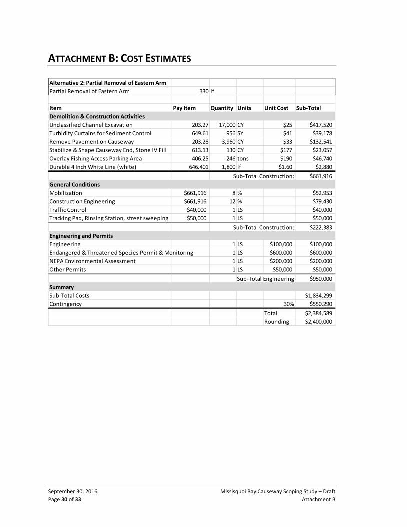
September 30, 2016 Missisquoi Bay Causeway Scoping Study – Draft
Page 30 of 33 Attachment B
ATTACHMENT B: COST ESTIMATES
Alternative 2: Partial Removal of Eastern Arm
Partial Removal of Eastern Arm 330 lf
Item Pay Item Quantity Units Unit Cost Sub‐Total
Demolition & Construction Activities
Unclassified Channel Excavation 203.27 17,000 CY $25 $417,520
Turbidity Curtains for Sediment Control 649.61 956 SY $41 $39,178
Remove Pavement on Causeway 203.28 3,960 CY $33 $132,541
Stabilize & Shape Causeway End, Stone IV Fill 613.13 130 CY $177 $23,057
Overlay Fishing Access Parking Area 406.25 246 tons $190 $46,740
Durable 4 Inch White Line (white) 646.401 1,800 lf $1.60 $2,880
Sub‐Total Construction: $661,916
General Conditions
Mobilization $661,916 8 % $52,953
Construction Engineering $661,916 12 % $79,430
Traffic Control $40,000 1 LS $40,000
Tracking Pad, Rinsing Station, street sweeping $50,000 1 LS $50,000
Sub‐Total Construction: $222,383
Engineering and Permits
Engineering 1 LS $100,000 $100,000
Endangered & Threatened Species Permit & Monitoring 1 LS $600,000 $600,000
NEPA Environmental Assessment 1 LS $200,000 $200,000
Other Permits 1 LS $50,000 $50,000
Sub‐Total Engineering $950,000
Summary
Sub‐Total Costs $1,834,299
Contingency 30% $550,290
Total $2,384,589
Rounding $2,400,000

Missisquoi Bay Causeway Scoping Study – Draft September 30, 2016
Page 31 of 33 Attachment B
Alternative 3
Remove Eastern Arm ‐ Phase I 330 lf
Item Pay Item Quantity Units Unit Cost Sub‐Total
Demolition & Construction Activities
Unclassified Channel Excavation 203.27 16,038 CY $25 $393,893
Turbidity Curtains for Sediment Control 649.61 956 SY $41 $39,178
Remove Pavement on Causeway 203.28 3,960 CY $33 $132,541
Stabilize & Shape Causeway End, Stone IV Fill 613.13 130 CY $177 $23,010
Overlay Fishing Access Parking Area 406.25 246 tons $190 $46,740
Durable 4 Inch White Line (white) 646.401 1,800 lf $1.60 $2,880
Sub‐Total Construction: $638,242
General Conditions
Mobilization $638,242 8 % $51,059
Construction Engineering $638,242 12 % $76,589
Traffic Control $40,000 1 LS $40,000
Tracking Pad, Rinsing Station, street sweeping $50,000 1 LS $50,000
Sub‐Total Construction: $217,648
Engineering and Permits
Engineering 1 LS $100,000 $200,000
Endangered & Threatened Species Permit & Monitoring 1 LS $600,000 $600,000
NEPA Environmental Assessment 1 LS $200,000 $200,000
Other Permits 1 LS $50,000 $50,000
Sub‐Total Engineering $1,050,000
Summary
Sub‐Total Costs $1,905,891
Contingency 30% $571,767
Total $2,477,658
Alternative 3
Remove Eastern Arm ‐ Phase II 330 lf
Item Pay Item Quantity Units Unit Cost Sub‐Total
Demolition & Construction Activities
Unclassified Channel Excavation 203.27 16,038 CY $25 $393,893
Turbidity Curtains for Sediment Control 649.61 956 SY $41 $39,178
Remove Pavement on Causeway 203.28 3,960 CY $33 $132,541
Stabilize & Shape Causeway End, Stone IV Fill 613.13 130 CY $177 $23,010
Overlay Fishing Access Parking Area 406.25 246 tons $190 $46,740
Durable 4 Inch White Line (white) 646.401 1,800 lf $1.60 $2,880
Sub‐Total Construction: $638,242
General Conditions
Mobilization $638,242 8 % $51,059
Construction Engineering $638,242 12 % $76,589
Traffic Control $40,000 1 LS $40,000
Tracking Pad, Rinsing Station, street sweeping $50,000 1 LS $50,000
Sub‐Total Construction: $217,648
Engineering and Permits
Engineering 1 LS $50,000 $50,000
Endangered & Threatened Species Permit & Monitoring 1 LS $600,000 $600,000
NEPA Environmental Assessment Update 1 LS $50,000 $50,000
Other Permits 1 LS $50,000 $50,000
Sub‐Total Engineering $750,000
Summary
Sub‐Total Costs $1,605,891
Contingency 30% $481,767
Total $2,087,658
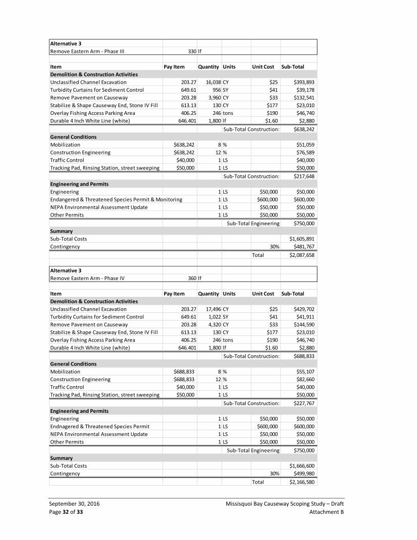
September 30, 2016 Missisquoi Bay Causeway Scoping Study – Draft
Page 32 of 33 Attachment B
Alternative 3
Remove Eastern Arm ‐ Phase III 330 lf
Item Pay Item Quantity Units Unit Cost Sub‐Total
Demolition & Construction Activities
Unclassified Channel Excavation 203.27 16,038 CY $25 $393,893
Turbidity Curtains for Sediment Control 649.61 956 SY $41 $39,178
Remove Pavement on Causeway 203.28 3,960 CY $33 $132,541
Stabilize & Shape Causeway End, Stone IV Fill 613.13 130 CY $177 $23,010
Overlay Fishing Access Parking Area 406.25 246 tons $190 $46,740
Durable 4 Inch White Line (white) 646.401 1,800 lf $1.60 $2,880
Sub‐Total Construction: $638,242
General Conditions
Mobilization $638,242 8 % $51,059
Construction Engineering $638,242 12 % $76,589
Traffic Control $40,000 1 LS $40,000
Tracking Pad, Rinsing Station, street sweeping $50,000 1 LS $50,000
Sub‐Total Construction: $217,648
Engineering and Permits
Engineering 1 LS $50,000 $50,000
Endangered & Threatened Species Permit & Monitoring 1 LS $600,000 $600,000
NEPA Environmental Assessment Update 1 LS $50,000 $50,000
Other Permits 1 LS $50,000 $50,000
Sub‐Total Engineering $750,000
Summary
Sub‐Total Costs $1,605,891
Contingency 30% $481,767
Total $2,087,658
Alternative 3
Remove Eastern Arm ‐ Phase IV 360 lf
Item Pay Item Quantity Units Unit Cost Sub‐Total
Demolition & Construction Activities
Unclassified Channel Excavation 203.27 17,496 CY $25 $429,702
Turbidity Curtains for Sediment Control 649.61 1,022 SY $41 $41,911
Remove Pavement on Causeway 203.28 4,320 CY $33 $144,590
Stabilize & Shape Causeway End, Stone IV Fill 613.13 130 CY $177 $23,010
Overlay Fishing Access Parking Area 406.25 246 tons $190 $46,740
Durable 4 Inch White Line (white) 646.401 1,800 lf $1.60 $2,880
Sub‐Total Construction: $688,833
General Conditions
Mobilization $688,833 8 % $55,107
Construction Engineering $688,833 12 % $82,660
Traffic Control $40,000 1 LS $40,000
Tracking Pad, Rinsing Station, street sweeping $50,000 1 LS $50,000
Sub‐Total Construction: $227,767
Engineering and Permits
Engineering 1 LS $50,000 $50,000
Endnagered & Threatened Species Permit 1 LS $600,000 $600,000
NEPA Environmental Assessment Update 1 LS $50,000 $50,000
Other Permits 1 LS $50,000 $50,000
Sub‐Total Engineering $750,000
Summary
Sub‐Total Costs $1,666,600
Contingency 30% $499,980
Total $2,166,580

Missisquoi Bay Causeway Scoping Study – Draft September 30, 2016
Page 33 of 33 Attachment B
Alternative 3 Summary Cost Estimate
Summary Construction
General
Conditions
Engineering
& Permits Contingency Total
Phase I $638,242 $217,648 $1,050,000 $571,767 $2,477,658
Phase II $638,242 $217,648 $750,000 $481,767 $2,087,658
Phase III $638,242 $217,648 $750,000 $481,767 $2,087,658
Phase IV $688,833 $227,767 $750,000 $499,980 $2,166,580
Totals $2,603,560 $880,712 $3,300,000 $2,035,282 $8,819,554
Rounding $8,900,000
Alternative 4
Remove Entire Western Arm ‐ Phase V 1340 lf
Item Pay Item Quantity Units Unit Cost Sub‐Total
Demolition & Construction Activities
Unclassified Channel Excavation 203.27 65,124 CY $25 $1,599,445
Turbidity Curtains for Sediment Control 649.61 3,200 SY $41 $131,200
Remove Pavement on Causeway 203.28 16,080 CY $33 $538,198
Stabilize & Shape Causeway End, Stone IV Fill 613.13 130 CY $177 $23,010
Sub‐Total Construction: $2,291,853
General Conditions
Mobilization $2,291,853 8 % $183,348
Construction Engineering $2,291,853 12 % $275,022
Traffic Control $40,000 1 LS $40,000
Tracking Pad, Rinsing Station, street sweeping $50,000 1 LS $50,000
Sub‐Total Construction: $548,371
Engineering and Permits
Engineering 1 LS $50,000 $50,000
Endangered & Threatened Species Permit & Monitoring 1 LS $600,000 $600,000
NEPA Environmental Assessment Update 1 LS $50,000 $50,000
Other Permits 1 LS $50,000 $50,000
Sub‐Total Engineering $750,000
Summary
Sub‐Total Costs $3,590,224
Contingency 30% $1,077,067
Total $4,667,291
Alternative 4 Summary Cost Estimate
Summary Construction
General
Conditions
Engineerin
g & Permits Contingency Total
Eastern Arm Phase I $638,242 $217,648 $1,050,000 $571,767 $2,477,658
Eastern Arm Phase II $638,242 $217,648 $750,000 $481,767 $2,087,658
Eastern Arm Phase III $638,242 $217,648 $750,000 $481,767 $2,087,658
Eastern Arm Phase IV $688,833 $227,767 $750,000 $499,980 $2,166,580
All of Western Arm ‐ Phase V $2,291,853 $548,371 $750,000 $1,077,067 $4,667,291
Totals $4,895,413 $1,429,083 $4,050,000 $3,112,349 $13,486,844
Rounding $13,500,000