
Mission Performance Centre - electronic library
19
SENTINEL-2 MISSION PERFORMANCE CENTRE / 1 Mission Performance Centre SENTINEL 2 RADIOMETRIC CAL/VAL S. CLERC, B. ALHAMMOUD, B. PFLUG, B. LAFRANCE, M. NEVEU VAN MALLE, J. LOUIS, C. BOUZINAC, L. PESSIOT, R. IANNONE, V. BOCCIA
Transcript of Mission Performance Centre - electronic library

SENTINEL-2 MISSION PERFORMANCE CENTRE / 1
Mission Performance Centre
SENTINEL 2 RADIOMETRICCAL/VAL
S. CLERC, B. ALHAMMOUD, B. PFLUG, B. LAFRANCE, M. NEVEU VAN MALLE, J. LOUIS, C. BOUZINAC, L. PESSIOT, R. IANNONE, V. BOCCIA

SENTINEL-2 MISSION PERFORMANCE CENTRE / 2/ 2
SENTINEL-2 RADIOMETRIC PERFORMANCE OBJECTIVES
Sentinel-2 is designed as a quantitative remote sensing mission
› Create consistent time series of surface reflectance measurements for
applications such as:
Vegetation monitoring
Land cover classification and change detection
Etc.
To achieve this goal we need:
› Accurate and stable radiometric accuracy at TOA
› Accurate surface reflectance (BOA) retrieval
Based on Sen2cor atmospheric correction processor
Production started worldwide end of 2018
New evolutions planned in the near future
› Uncertainty estimates
Current provided by the Radiometric Uncertainty Tool at L1C
Agra, Uttar Pradesh
SENTINEL-2 MISSION PERFORMANCE CENTRE / 3/ 3
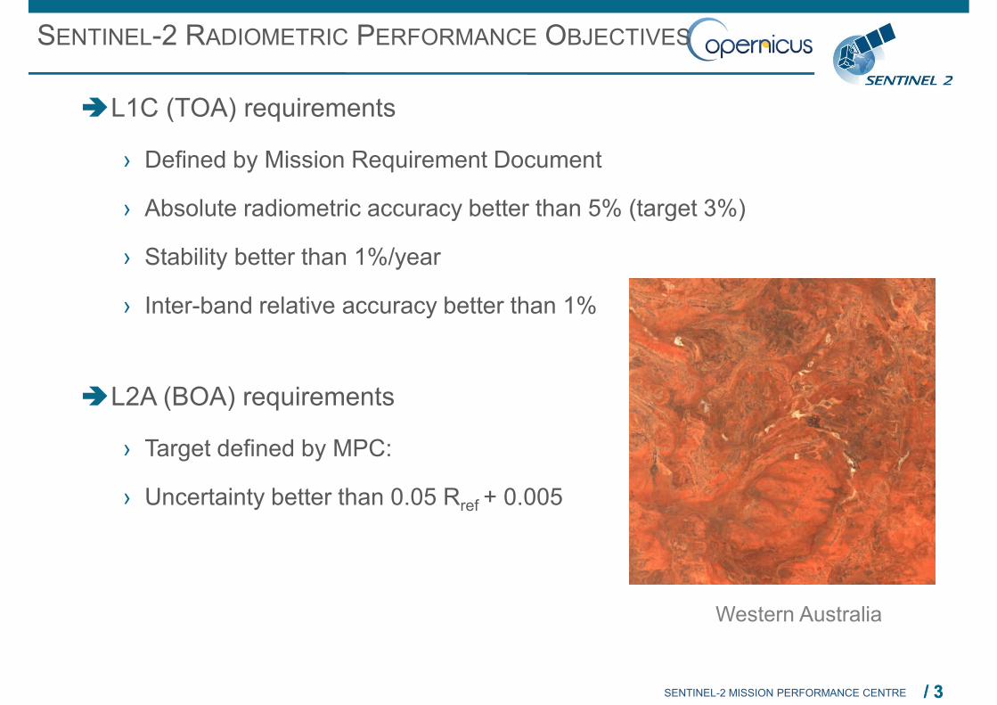
SENTINEL-2 RADIOMETRIC PERFORMANCE OBJECTIVES
L1C (TOA) requirements
› Defined by Mission Requirement Document
› Absolute radiometric accuracy better than 5% (target 3%)
› Stability better than 1%/year
› Inter-band relative accuracy better than 1%
L2A (BOA) requirements
› Target defined by MPC:
› Uncertainty better than 0.05 Rref + 0.005
Western Australia

SENTINEL-2 MISSION PERFORMANCE CENTRE / 4/ 4
SENTINEL-2 RADIOMETRIC CALIBRATION APPROACH
On-board calibration device
› White solar diffuser (single unit)
› Used as reference reflectance for gains adjustment and equalisation (flat-
fielding), and to monitor pixel health status
Dark signal calibration using night-time Ocean acquisitions

SENTINEL-2 MISSION PERFORMANCE CENTRE / 5/ 5
RADIOMETRIC CALIBRATION APPROACH
Radiometric calibration activities led by MPC/CS
Example diffuser image
Diffuser image: before (left) and after (right) equalization

SENTINEL-2 MISSION PERFORMANCE CENTRE / 6/ 6
RADIOMETRIC CALIBRATION APPROACH
Calibration operations are performed routinely once per month for Sentinel 2A and 2B
› Faster degradation of the absolute gains for SWIR bands (B10 & B11) due to ice contamination
Periodic focal plane decontamination
› Recovers nominal sensitivity of SWIR bands
› Periodicity changed from 6 months to one year

SENTINEL-2 MISSION PERFORMANCE CENTRE / 7/ 7
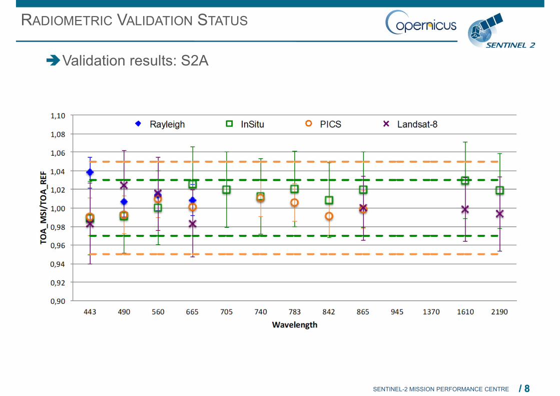
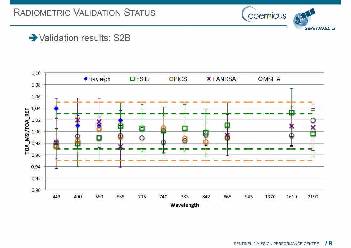
RADIOMETRIC VALIDATION: LEVEL 1C
Radiometry is continuously monitored using different methods by MPC/ARGANS implemented in DIMITRI software:
› Rayleigh
› PICS
› In-situ (RailRoad Valley data provided
by NASA/U. Arizona)
› Cross-mission comparisons
› Ad-hoc methods for inter-band: DCC, Sun-glint
Estimated performance:
› S2A and S2B are meeting the requirements (goal value 3%) for all bands
› Temporal stability is excellent << 1%/year for all bands
› Inter-band performance better than 1% (TBC)
› Indication of a small systematic bias between S2A and S2B: ~1% (S2B darker)
SENTINEL-2 MISSION PERFORMANCE CENTRE / 8/ 8
RADIOMETRIC VALIDATION STATUS
Validation results: S2A
SENTINEL-2 MISSION PERFORMANCE CENTRE / 9/ 9
RADIOMETRIC VALIDATION STATUS
Validation results: S2B
SENTINEL-2 MISSION PERFORMANCE CENTRE / 10/ 10
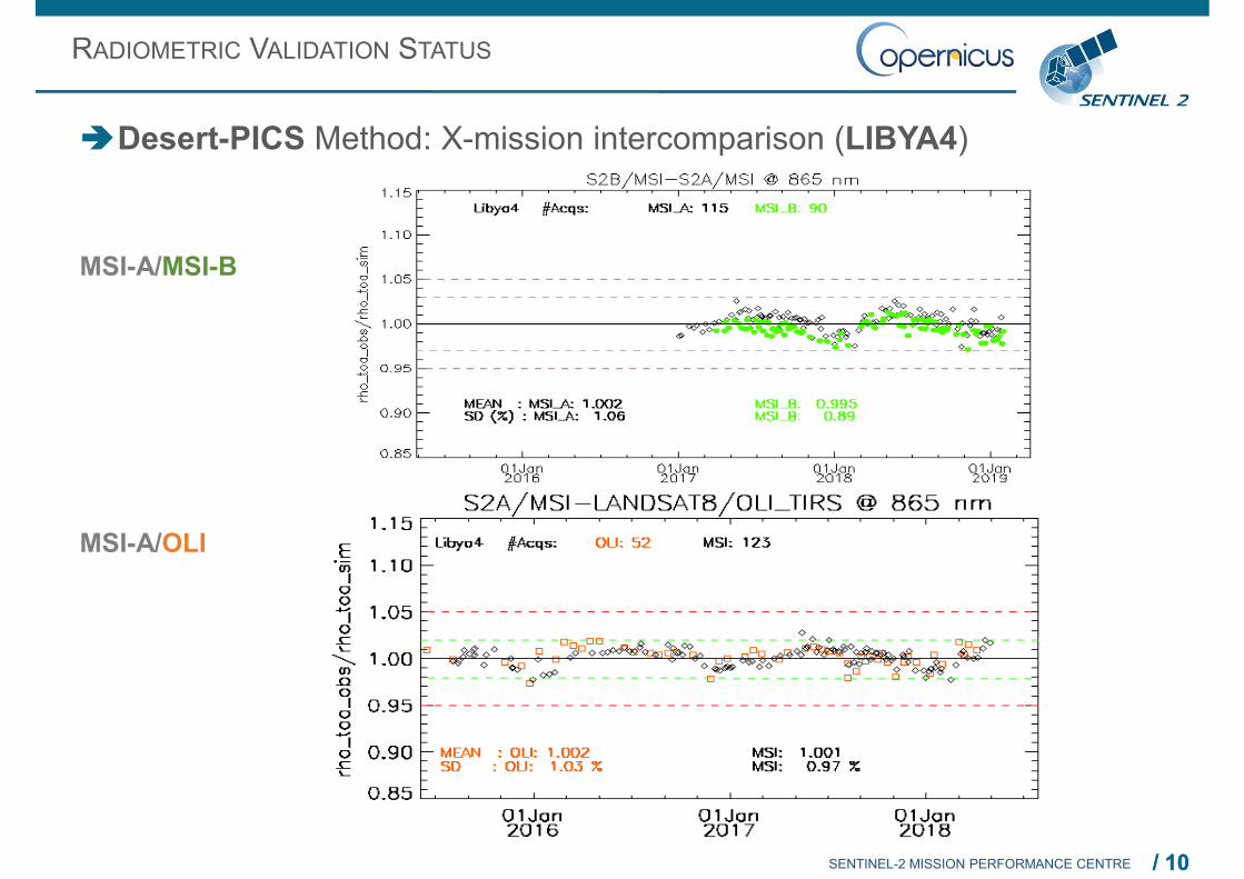
RADIOMETRIC VALIDATION STATUS
Desert-PICS Method: X-mission intercomparison (LIBYA4)
MSI-A/MSI-B
MSI-A/OLI

SENTINEL-2 MISSION PERFORMANCE CENTRE / 11/ 11
RADIOMETRIC VALIDATION: LEVEL 2
Surface Reflectance Radiometric validation led by MPC/DLR
Methods & approaches:
› “ACIX-like” validation: comparison with 6S inversion using AERONET measurements
› Ad-hoc ground measurement campaign: Lake Stechlin, May 2018 Analysis in progress
Performance estimation status
› ACIX-like approach Accuracy is acceptable but relatively large bias observed
Applied on previous version of the L2A processor: update needed (ACIX-2)
Poor performance on B05 and B12 bands not confirmed by ground measurements: methodology issue ?
› Field campaign Good performance both on water and grass
› Airborne measurements Analysis in progress
SENTINEL-2 MISSION PERFORMANCE CENTRE / 12/ 12
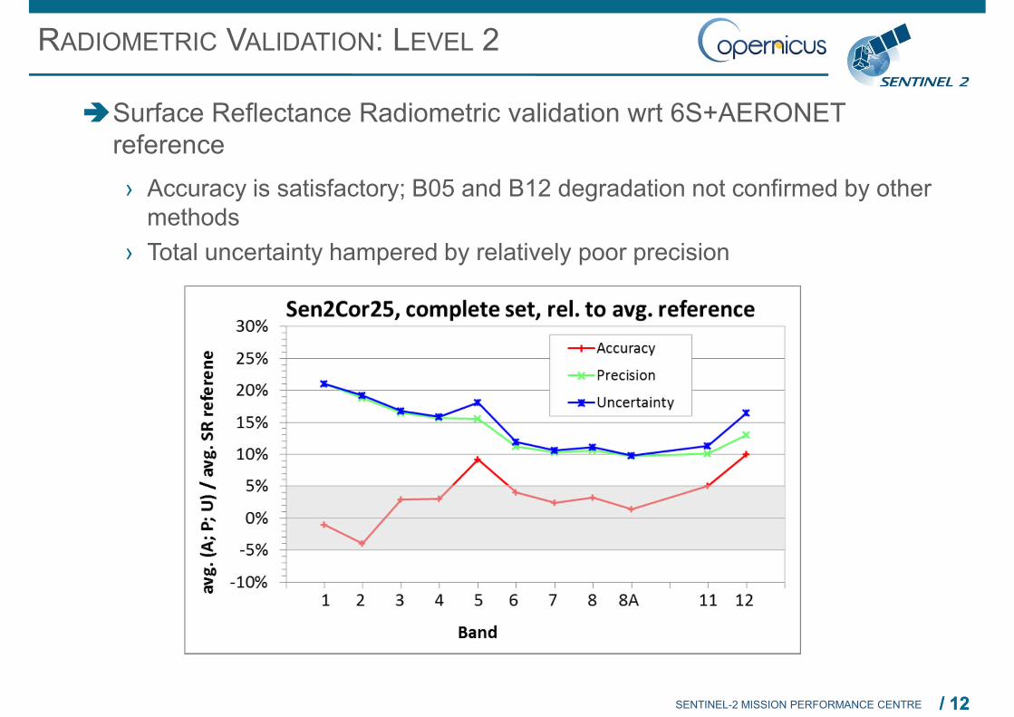
RADIOMETRIC VALIDATION: LEVEL 2
Surface Reflectance Radiometric validation wrt 6S+AERONET reference
› Accuracy is satisfactory; B05 and B12 degradation not confirmed by other methods
› Total uncertainty hampered by relatively poor precision

SENTINEL-2 MISSION PERFORMANCE CENTRE / 13/ 13
RADIOMETRIC VALIDATION: LEVEL 2
Lake Stetchlin campaign 4th May 2018
› Field campaign + aerial acquisition with HySpex instrument
Landsat 8 over-pass10:02
Sentinel-2B over-pass10:10
Lake Stechlin
Berlin

SENTINEL-2 MISSION PERFORMANCE CENTRE / 14/ 14
RADIOMETRIC VALIDATION: LEVEL 2
Field measurements over meadow (grass)
Good agreement for all bands, except B09 (impact of water vapour)
SENTINEL-2 MISSION PERFORMANCE CENTRE / 15/ 15
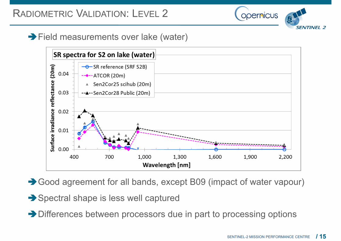
RADIOMETRIC VALIDATION: LEVEL 2
Field measurements over lake (water)
Good agreement for all bands, except B09 (impact of water vapour)
Spectral shape is less well captured
Differences between processors due in part to processing options

SENTINEL-2 MISSION PERFORMANCE CENTRE / 16/ 16
CONCLUSION AND OUTLOOK
Sentinel-2 Radiometric Calibration and Validation status
› The radiometric performance of Sentinel-2 is excellent, in terms of accuracy, uniformity and stability
› Sentinel-2 has become a reliable reference sensor in the VIS/NIR/SWIR range
Can we go further ?
› Perspectives and lessons learned….
Chamdo City, Tibet
SENTINEL-2 MISSION PERFORMANCE CENTRE / 17/ 17
CONCLUSION AND OUTLOOK
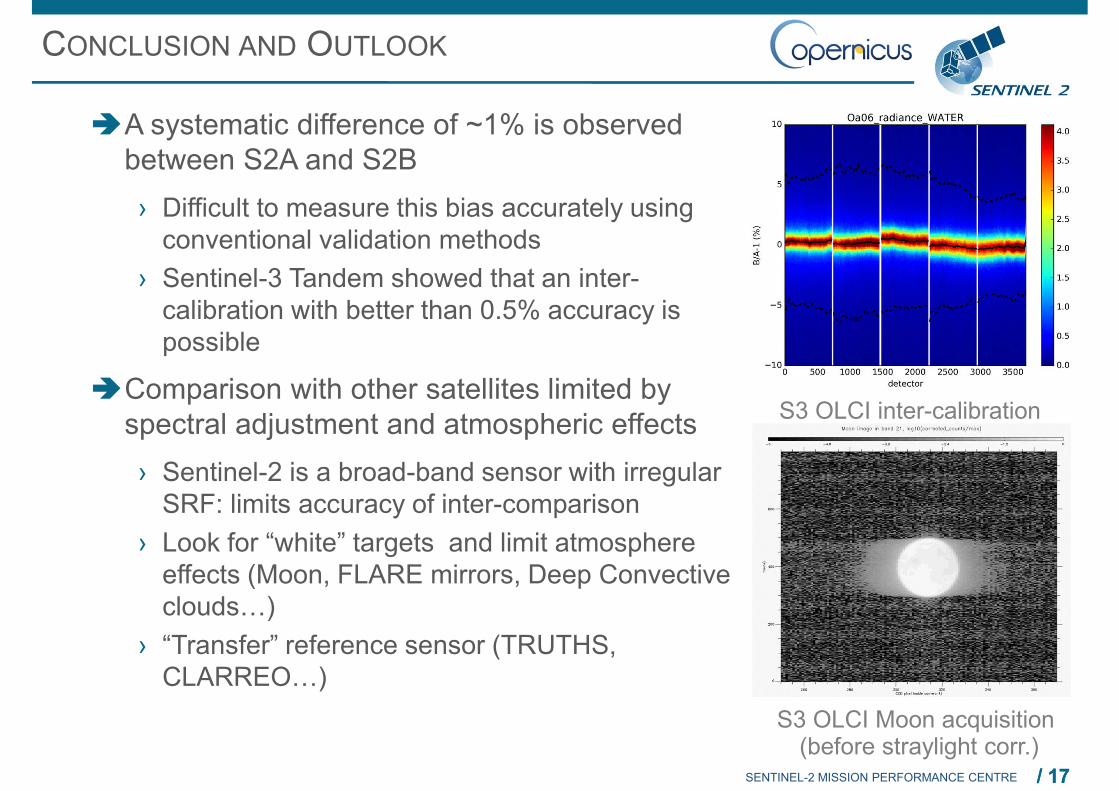
A systematic difference of ~1% is observed between S2A and S2B
› Difficult to measure this bias accurately using conventional validation methods
› Sentinel-3 Tandem showed that an inter-calibration with better than 0.5% accuracy is possible
Comparison with other satellites limited by spectral adjustment and atmospheric effects
› Sentinel-2 is a broad-band sensor with irregular SRF: limits accuracy of inter-comparison
› Look for “white” targets and limit atmosphere effects (Moon, FLARE mirrors, Deep Convective clouds…)
› “Transfer” reference sensor (TRUTHS, CLARREO…)
S3 OLCI inter-calibration
S3 OLCI Moon acquisition (before straylight corr.)

SENTINEL-2 MISSION PERFORMANCE CENTRE / 18/ 18
CONCLUSION AND OUTLOOK
Atmospheric correction is very sensitive to physical modelling and spectral sampling
› Reference software (e.g. E-Radiate project)
› Benchmarking exercises (ACIX, ACIX-2)
Dedicated surface reflectance validation measurement sites needed
› Intermediate step between
TOA cal/val sites (such as RadCalNet sites)
And land product validation sites (e.g. GBOV, FRM4VEG)
› Vegetated sites with variable atmospheric conditions, with characterization of the BRDF
› Related work
HYPERNETS project
SENTINEL-2 MISSION PERFORMANCE CENTRE / 19/ 19
CONCLUSION AND OUTLOOK
Questions?
Acknowledgment:
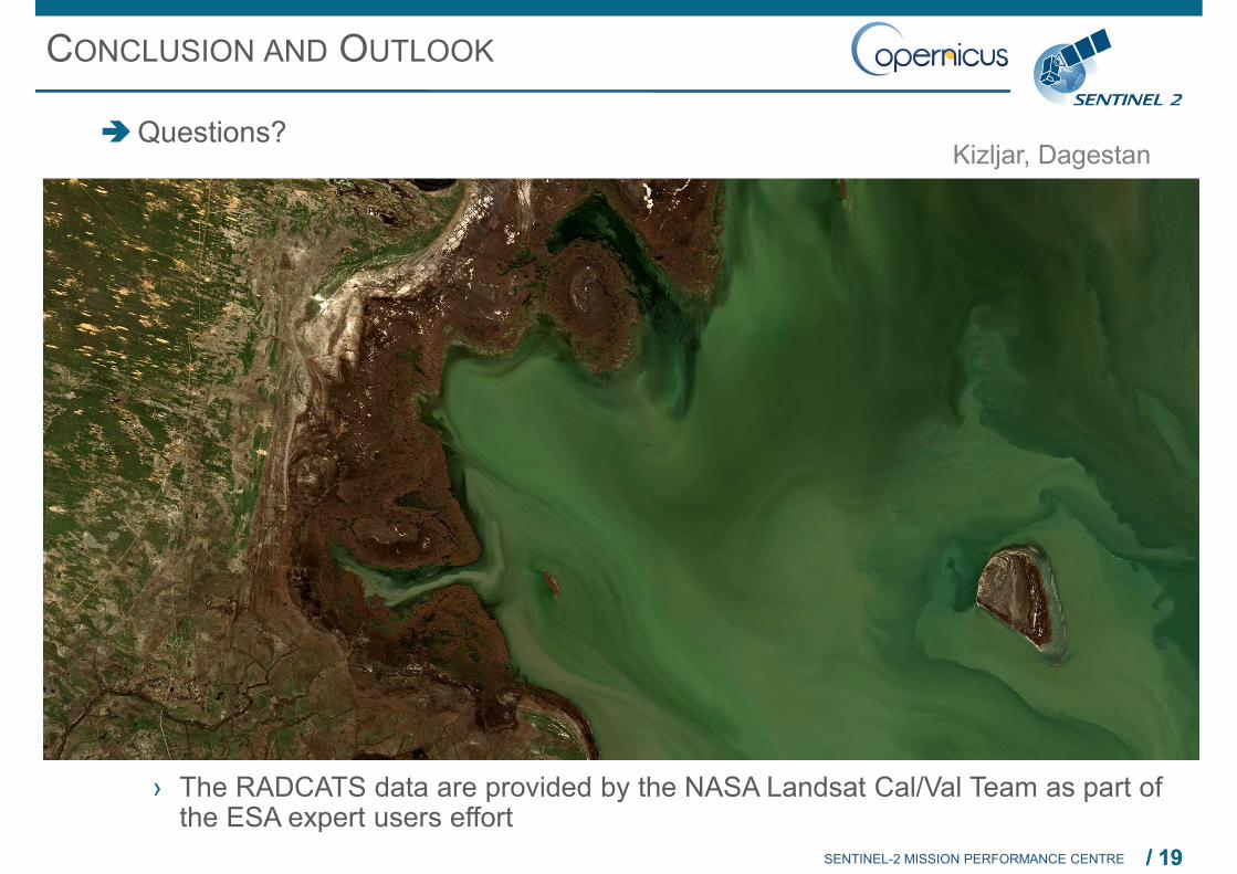
› The RADCATS data are provided by the NASA Landsat Cal/Val Team as part of the ESA expert users effort
Kizljar, Dagestan


