Minta Farm Draft Precinct Structure Plan - Background Report · PDF fileMinta Farm Draft...
37
Minta Farm Draft Precinct Structure Plan - Background Report October 2017
Transcript of Minta Farm Draft Precinct Structure Plan - Background Report · PDF fileMinta Farm Draft...

Minta Farm Draft Precinct
Structure Plan - Background
Report
October 2017


PSP11 – MINTA FARM – DRAFT PSP BACKGROUND REPORT – OCTOBER 2017 1
CONTENTS
1 Executive Summary .................................................................................................................................... 3
1.1 Purpose ............................................................................................................................................ 3
1.2 Summary of PSP .............................................................................................................................. 3
1.3 Background Documents .................................................................................................................... 3
2 Strategic Context ......................................................................................................................................... 5
2.1 Plan Melbourne 2017-2050 ............................................................................................................... 5
2.2 South East Growth Corridor Plan ...................................................................................................... 6
2.3 C21: A vision for our future ............................................................................................................... 7
2.4 Response in the PSP ........................................................................................................................ 7
2.5 Demographic Forecast ...................................................................................................................... 7
3 Physical Context ......................................................................................................................................... 9
3.1 Topography ..................................................................................................................................... 10
3.2 Water bodies ................................................................................................................................... 10
3.3 Biodiversity ..................................................................................................................................... 11
3.4 Vegetation ....................................................................................................................................... 13
3.5 Heritage .......................................................................................................................................... 13
3.6 Hydrology, Contamination and Geotechnical .................................................................................. 17
3.7 Boundary Re-establishment ............................................................................................................ 18
4 Land Use, Development and Infrastructure Needs ................................................................................... 19
4.1 Community Facilities ....................................................................................................................... 19
4.2 Non-Government Schools ............................................................................................................... 20
4.3 Retail ............................................................................................................................................... 22
4.4 Employment Land ........................................................................................................................... 23
4.5 Open Space .................................................................................................................................... 24
4.6 Council Community Services .......................................................................................................... 25
4.7 Road Network ................................................................................................................................. 25
4.8 Alternative Transport Network ........................................................................................................ 29
4.9 Drainage and Stormwater ............................................................................................................... 30

2 PSP11 – MINTA FARM – DRAFT PSP BACKGROUND REPORT – OCTBOER 2017
4.10 Servicing ......................................................................................................................................... 30
4.11 Infrastructure Contributions Plan .................................................................................................... 31
4.12 Response in the PSP ...................................................................................................................... 32
5 Vision and Priciple of the Minta Farm PSP................................................................................................ 33
5.1 Vision for the Minta Farm Precinct .................................................................................................. 33
5.2 Principles for the Plan ..................................................................................................................... 33
TABLES
Table 1 Population Forecasts City of Casey ...................................................................................................... 8
Table 2 Retail and Floor Space Provision in Centres ....................................................................................... 22
Table 3 Existing and Planned Road Network ................................................................................................... 28
Table 4 Infrastructure Treatments with External Apportionment ...................................................................... 32
FIGURES
Figure 1 Plan Melbourne 2017 Extract – Melbourne 2050 Plan ........................................................................ 5
Figure 2 Precinct location in the South East Growth Corridor Plan ................................................................... 6
Figure 3 Aerial of the Precinct ........................................................................................................................... 9
Figure 4 Precinct Topography ......................................................................................................................... 10
Figure 5 Extract from Biodiversity Conservation Strategy for Melbourne’s Growth Areas ............................... 12
Figure 6 Structures Assessed for Post-Contact Heritage Significance ............................................................ 14
Figure 7 Recommended Curtilage of Myer House .......................................................................................... 15
Figure 8 Areas of Cultural Heritage Sensitivity ................................................................................................ 16
Figure 9 Potential On-Site Contamination ....................................................................................................... 17
Figure 10 Precinct Features Plan Identifying Re-Established Boundaries ...................................................... 18
Figure 11 Existing and Planned Schools ......................................................................................................... 21
Figure 12 Approved Subdivision Plan for Grices Road Local Convenience Centre in Clyde North PSP ......... 23
Figure 13 Interim Scenario Road Network from 2014 and 2015 Modelling ..................................................... 27
Figure 14 Ultimate Network for 2046 from 2015 Modelling ............................................................................. 28

PSP11 – MINTA FARM – DRAFT PSP BACKGROUND REPORT – OCTOBER 2017 3
1 EXECUTIVE SUMMARY
1.1 Purpose
This report summarises the key findings presented by the technical reports and analysis that informed the preparation of the Minta Farm (formerly known as C21 Business Park) Precinct Structure Plan (PSP); and explains how this information guided the preparation of the proposed future urban structure. More specifically, this report:
Summarises the strategic context of the precinct.
Outlines the physical context of the site including topography, vegetation, waterways and contamination.
Identifies the land use and development needs for the precinct.
Explains how the PSP responds to the key findings of the above.
The technical reports listed in section 1.3 provide specific detail on the key elements outlined by this report.
1.2 Summary of PSP
In summary, the Minta Farm precinct:
Will be a “business with residential” precinct as guided by strategic planning policy.
Will provide a total of 83 hectares of employment, with 69 hectares within a dedicated office and business park, 10 hectares of mixed use and 4 hectares for a local town centre. The local town centre will serve a largely local catchment.
Plans for a population of around 8,000 people at various residential densities in response to walkable catchments within the urban structure.
Comprises an urban structure that draws upon and integrates the site’s existing physical features including undulating topography, built form heritage, significant native and exotic vegetation, a natural and constructed waterway system and an area of biodiversity significance.
Will set aside a conservation area that comprises the Cardinia Creek corridor and three of the four existing constructed lakes that sit alongside the creek.
Provides an extensive open space network designed with the site’s topography and natural features.
Requires the following infrastructure:
Road network.
Drainage stormwater system.
Primary school.
Community facility.
Sports reserve and local parks.
Services.
1.3 Background Documents
Technical investigations and findings that were used to inform the preparation of this report and the Minta Farm PSP include:
State and local planning policy framework, including the Casey Planning Scheme.
Minta Farm PSP Employment Precinct Land Review, VPA, October 2017.
Minta Farm PSP Surface Water Management Strategy, Engeny, October 2017.
Minta Farm PSP Stage 1 and 2 Desktop Environmental, Hydrogeological and Geotechnical Assessment, SKM, February 2011.

4 PSP11 – MINTA FARM – DRAFT PSP BACKGROUND REPORT – OCTBOER 2017
C21 Business Park Biodiversity Assessment Report, Practical Ecology, November 2011.
Clyde North. C21 Business Park and Cranbourne North (Stage 2) Precincts, Aboricultural Assessment, December 2008.
Heritage Advice for the Myer House, Minta Farm, Berwick (Stages 1, 2 and 3), GJM, July 2011.
Minta Farm Historic Cultural Heritage Assessment, Tardis Enterprises, February 2011.
Minta Farm PSP Concept Road Design Report, TrafficWorks, October 2017.
Traffic Engineering Assessment – Additional Traffic Modelling, Traffix Group, September 2017.

PSP11 – MINTA FARM – DRAFT PSP BACKGROUND REPORT – OCTOBER 2017 5
2 STRATEGIC CONTEXT
The Minta Farm precinct falls within the South East Growth Corridor and the City of Casey.
Key strategic documents that are relevant to the PSP are listed below and outlined thereafter:
Plan Melbourne 2017-2050.
South East Growth Corridor Plan.
C21: A vision for our future.
As well, the strategic context is informed by the demographic forecast.
2.1 Plan Melbourne 2017-2050
Plan Melbourne 2017-2050 provides high level strategic guidance for land use and development across the metropolitan area. This document was released during March 2017.
Plan Melbourne 2017-2050 identifies the Minta Farm PSP area as an “urban area”, abutting a state-significant road corridor, nearby a rail improvement corridor and adjacent to a state-significant industrial precinct.
Figure 1 Plan Melbourne 2017 Extract – Melbourne 2050 Plan
Minta Farm PSP

6 PSP11 – MINTA FARM – DRAFT PSP BACKGROUND REPORT – OCTBOER 2017
2.2 South East Growth Corridor Plan
The Growth Corridor Plans were prepared by the Victorian Planning Authority (then the Growth Areas Authority) and released by the Minister for Planning in June 2012. The plans seek to accommodate a substantial amount of Melbourne’s future housing and employment land supply over the subsequent 30 to 40 years by providing a framework to guide the planning of new communities in each corridor.
The Minta Farm PSP area is located in the South-East Growth Corridor (SEGC). This corridor includes land within the municipalities of Casey and Cardinia. The SEGC area is expected to accommodate a population of approximately 230,000 people and has the capacity to provide around 86,000 jobs.
The projected growth within the SEGC has informed the broader sub-regional network of service and infrastructure provision. This means that as well as providing its own local services, the PSP planning needs to ensure there is no shortfall or loss of services within the broader growth area context (refer to Figure 2).
The SEGC plan identifies the Minta Farm PSP area as “business with residential”. Documents prepared to support the preparation of the SEGC described “business with residential” as mixed use areas for office, research and development and associated manufacturing facilities.
The precinct forms part of a more extensive regionally significant employment corridor identified to support business enterprise and employment growth extending south of the Princess Freeway toward Pakenham.
Figure 2 Precinct location in the South East Growth Corridor Plan
Minta Farm PSP

PSP11 – MINTA FARM – DRAFT PSP BACKGROUND REPORT – OCTOBER 2017 7
2.3 C21: A vision for our future
Casey’s C21 plan was prepared in 2002 to set out a vision for the City. Specific to the PSP area, the plan includes the following vision: “This Park is to be …. a high amenity, quality business and elaborately transformed manufacturing park, together with integrated research, commercial, learning and living spaces with freeway access and a focus towards a wide wetlands and parkland space along Cardinia Creek”.
2.4 Response in the PSP
In response to the key strategic documents above, the PSP plans for:
A new urban precinct within an area already identified as “urban” in Plan Melbourne 2017 – 2050.
A mixed residential and employment precinct as per the SEGC plan.
An employment precinct that provides for business and technology uses as guided by C21: A vision for our Future.
2.5 Demographic Forecast
Demographic forecasts provide guidance on expected population numbers and community profiles and are used to form the basis for infrastructure provision and catchment planning. Demographic forecasts are considered generally at the broader corridor level and further tested more specifically at the precinct level.
Broader corridor level context comprises the established suburbs of Casey, the adjoining establishing suburbs of Cranbourne and Berwick South as well as the Brompton Lodge PSP area (Figure 2).
2.5.1 The Existing and Future Casey Community Forecasts
According to the 2011 Australian Bureau of Statics (ABS) data, the Casey population was approximately 297,000. Assuming the calculated occupancy rate of 2.9 persons per dwelling, this suggests there were approximately 102,400 existing dwellings.
The additional Casey population anticipated through the delivery of remaining urban land within PSP areas (including the approved, commenced and not commenced PSPs), is forecast to be 235,200, comprising 84,400 dwellings.
In total, the ultimate Casey population estimation is approximately 514,000 people, comprising 181,000 dwellings. This population is expected to be reached by around 2040 to 2045. The population growth expected in PSP areas surrounding the Minta Farm precinct are identified in Table 1.
2.5.2 Demographic Profile of the PSP Area and Wider Casey Context
The City of Casey’s community profile for the Berwick South and Cranbourne North areas provides an understanding of the likely demographic profile expected for the PSP area. The key characteristics anticipated of the Minta Farm community are largely typical of an establishing outer growth area community, which encompasses the following:
A high percentage of households with children, and a lower percentage of mature adults and senior citizens (65-84 years).
A high percentage of people that are purchasing their own home, and a low percentage of households that own their home.
A high percentage of people employed full time and a slightly lower percentage of people unemployed.
Main occupation categories of intermediate clerical, sales and service workers, tradespersons and related workers and professionals.
Over half of total families to be couple families with children.

8 PSP11 – MINTA FARM – DRAFT PSP BACKGROUND REPORT – OCTBOER 2017
Table 1 Population Forecasts City of Casey
2.5.3 Response in the PSP
The PSP will plan for the above-identified demographic forecasts by:
Planning for housing diversity by guiding a range of residential densities and encouraging a range of housing types.
Providing community infrastructure in accordance with standard provision ratios and in consideration of facilities available in the surrounding areas (see Section 4.1 for further discussion).
CASEYPSP
NumberDescription
PSP Total Land Area (Ha)
Dwellings Population
N.A. 96,419 278,816
15 Cranbourne North (Stage 1) 310 2,538 7,106
17 Cranbourne West 793 4,481 12,547
14 Cranbourne East 578 6,608 18,502
16 Cranbourne North (Stage 2) 189 2,056 5,757
13 & 1052 Clyde North (with Pound Road) 612 6,605 18,494
10 (STG 1) Botanic Ridge Stage 1 280 1,450 4,060
10 Botanic Ridge (Stages 2 & 3) 317 3,425 9,590
1054 Clyde Creek 1,154 13,709 38,385
1053 Thompsons Road 695 6,482 18,150
9 Berwick Waterways 85 908 2,542
1057.1 Casey Fields South - Residential 110 1,463 4,096
5,124 49,725 139,230
11 'Minta Farm' C21 Business Park 286 3,186 8,921
12 Casey Central Town Centre 60 1,853 4,136
1051 Croskell 272 2,200 6,160
1055 McPherson 952 10,100 28,280
1,693 17,339 47,497
1056 Clyde South 1,096 13,140 36,792
1057.2 Casey Fields South - Employment 231 0 0
1058 Devon Meadows 261 1,559 4,365
1218 Botanic Ridge (stage 4) 69 632 1,770
1,657 15,331 42,927
PSPs Removed from Program (Possible very long term Council)N.A. Hampton Park South 109 500 1,400
1044 Collison Estate 84 600 1,680
109 500 1,400
1209 Brompton Lodge 112 1,484 4,155
112 1,484 4,155
180,798 514,025
Casey Non PSP Areas*
Est. Total Build Out
TOTALS CASEY
Gazetted PSP's
Subtotal
Subtotal
* Estimate only
Commenced / Underway (latest draft estimates - subject to revision)
Not Commenced (preliminary numbers only)
Logical Inclusions
Subtotal
Subtotal
Subtotal
(Source: VPA 2017)

PSP11 – MINTA FARM – DRAFT PSP BACKGROUND REPORT – OCTOBER 2017 9
3 PHYSICAL CONTEXT
The Minta Farm PSP area comprises approximately 285 hectares of land and is generally bounded by the Princes Freeway and O’Shea Road reservation to the north, Cardinia Creek to the east, Grices Road to the south and Soldiers Road to the west (see Figure 3).
The precinct has been used for farming purposes for the last 100 years or so. The few structures present on the site are associated the current and former homestead. Patches of vegetation are scattered throughout the precinct including more concentrated strands around the former homestead, along the precinct boundary and within the Cardinia Creek corridor. A boundary re-establishment has recently been approved by Land Use Victoria but is yet to be formally recognised in title.
The physical context of the Minta Farm PSP is characterised by:
Topography.
Water bodies.
Biodiversity.
Vegetation.
Post-contact heritage.
Cultural heritage.
In addition, a Stage 1 and 2 Environmental, Hydrogeological and Geotechnical Assessment assessed the following site features:
Hydrology.
Contamination.
Geotechnical.
Figure 3 Aerial of the Precinct

10 PSP11 – MINTA FARM – DRAFT PSP BACKGROUND REPORT – OCTBOER 2017
3.1 Topography
Topography within the PSP area undulates in the west and falls away to a floodplain moving east towards the Cardinia Creek corridor.
The western half of the precinct is characterised by an elevated topography that falls into two smaller hilltops. The central hilltop forms a prominent landform within the precinct, offering both short and long range views to Cardinia Creek and the Dandenong Ranges respectively.
The eastern half of the precinct is comparatively flatter and slopes gently from the hilltops down to flat land adjacent Cardinia Creek as part of a natural flood plain.
Of note, there is also a significant grade difference between the Princes Freeway and the precinct.
3.1.1 Response in the PSP
The future urban structure, as identified in Plan 3 of the PSP, has been designed to draw upon the natural topography of the site:
The district park has been located to maximise views offered by the raised landform.
The employment precinct is situated in the north-west to provide it with the necessary flatter land. As well, commercial land is better suited to the unhospitable frontage of the Princes Freeway.
The sports reserve sits within a flatter area of land within the residential catchment area.
Requirements and Guidelines within the PSP guide the integration of future subdivision design with the natural topography.
Figure 4 Precinct Topography
3.2 Water bodies
There are three key water systems within the PSP area:
(Source: VPA analysis of DELWP 2009 Lidar survey, Coordinated Imagery Program)

PSP11 – MINTA FARM – DRAFT PSP BACKGROUND REPORT – OCTOBER 2017 11
1 Cardinia Creek, at the eastern boundary, which contains key environmental, recreational and landscape qualities.
2 Baillieu Creek, a lower order watercourse, flows diagonally in a south-easterly direction through the precinct and onto Cardinia Creek at the southern boundary of the PSP area.
3 Constructed lake system comprising four lakes which sits alongside Cardinia Creek at the eastern boundary. This was constructed as part of an agricultural irrigation system and, over time, has integrated with the ecosystem of the creek.
Water generally flows west to east across the site with the topography.
Cardinia Creek forms a natural eastern boundary to the PSP area. Cardinia Creek extends around 5 kilometres north of the PSP area (as the crow flies) from the Cardinia Reservoir and continues southwards to Western Port Bay. The creek corridor forms part of an existing conservation area.
Baillieu Creek is Minta Farm’s main drainage waterway which conveys stormwater flows from the Baillieu Creek sediment basin to the northernmost constructed lake.
Of the four constructed lakes, three have been assessed as now forming part of the conservation area as they are habitat to significant species. The fourth and northernmost lake is proposed to form part of the future stormwater management system, as discussed further below.
3.2.1 Response in the PSP
Urban development flows across the PSP area will be managed through a stormwater management strategy prepared specifically for the site. This strategy seeks to maintain pre-development flows, incorporating the northernmost constructed lake.
The PSP sets aside the Cardinia Creek corridor and three constructed lakes as part of the conservation area.
3.3 Biodiversity
Biodiversity features of the site are concentrated along the Cardinia Creek corridor, known for being a habitat for a number of Environment Protection and Biodiversity Conservation Act 1999 (EPBC Act) listed threatened species including:
Growling Grass Frog (GGF)
Dwarf Galaxias
Australian Grayling
Numerous bird species, including migratory birds
The Creek’s riparian zone, measured at 100 metres from the creek line, forms part of the wider Conservation Area 36 (see Figure 5). The Biodiversity Conservation Strategy (BCS) for Melbourne’s Growth Corridors (DEPI, 2013), which is the primary policy and legislative mechanism for biodiversity protection and management of matters of national environmental significance, identifies Conservation Area 36 as Growling Grass Frog (GGF) habitat.
The BCS identified GGF conservation areas that must be protected and enhanced in order to achieve conservation outcomes for the frog species. Funds collected from those developing land will be invested in the creation, enhancement and management of GGF habitat in conservation areas established under the BCS. The BCS requires that land designated for GGF conservation is transferred to the Department of Environment, Land Water and Planning (DELWP) at the time of subdivision.
The boundaries of the conservation area have been established by the Department of Environment, Land, Water and Planning. In part these boundaries have been informed by Practical Ecology’s biodiversity assessment undertaken for the Minta Farm precinct in 2010, prior to the application of the BCS. The boundaries include those parts of the constructed lake system which have been identified as supporting a number of small islands which serve as breeding grounds for numerous bird species including migratory birds. More specifically, the

12 PSP11 – MINTA FARM – DRAFT PSP BACKGROUND REPORT – OCTBOER 2017
conservation area includes a 20 metre buffer, measured from the high waterline, of the southernmost constructed lake to manage habitat for the Latham Snipe, an EPBC Act listed migratory (marine) species, of which 15 were sighted by Practice Ecology (2011) within a 10 kilometres radius of the study area.
Practical Ecology also recorded seven scattered trees. Five of these are contained alongside the southern pond within the Cardinia Creek riparian corridor and the remaining two are located in the lower central farm lands of the Minta Farm PSP area.
Figure 5 Extract from Biodiversity Conservation Strategy for Melbourne’s Growth Areas
3.3.1 Response in the PSP
The PSP will provide for the long-term protection and management of Conservation Area 36 by identifying the conservation area boundaries, prohibiting land use and development within the area and providing guidance on the location of future recreation infrastructure anticipated for the corridor.
Works within the conservation area will need to be in accordance with the Growling Grass Frog Habitat Design Standards: Melbourne Strategic Assessment (DELWP, 2017). The purpose of these standards is to provide guidance on protecting and creating the various types of habitat required to support metapopulations of GGF over the long term.
The Conservation Area Concept Plan within the PSP has been prepared in collaboration with DELWP, as well as Council.
Subsequent to the PSP process, the design standards will also be used by DELWP to:
Assess infrastructure proposals within GGF conservation areas.
Design and construct GGF wetlands and associated project specifications.
Review completed GGF wetland projects.
Minta Farm PSP

PSP11 – MINTA FARM – DRAFT PSP BACKGROUND REPORT – OCTOBER 2017 13
3.4 Vegetation
The PSP area has historically been used for agricultural purposes and as a result, is largely clear of native vegetation. However some significant patches remain, as do some scattered trees dispersed along Cardinia Creek.
Other than the trees protected by the BCS, there are a number of highly aesthetic exotic trees across the PSP area as assessed by Treelogic in 2008. These exotics are located predominantly around the original homestead and in a patch adjacent the constructed lakes.
3.4.1 Response in the PSP
Plan 5 of the PSP illustrates that the two largest passive open space areas have been located and designed to integrate the existing exotic trees of aesthetic value. It is anticipated that future master planning for these parks will include a more detailed tree assessment to ensure the design of the parks maximise the retention and longevity of these trees.
Plan 8 of the PSP illustrates the native vegetation retention and conservation areas which will preserve identified vegetation of areas of value.
3.5 Heritage
3.5.1 Post Contact Heritage
Two post-contact heritage assessments have been completed for the Minta Farm PSP area:
Tardis assessed the overall PSP area in 2011.
GJM undertook a targeted assessment of the Myer House in 2017.
The focus of the post-contact heritage elements on the site, and thereby Tardis’ report, was the raised landform within the south-west quadrant of the PSP area coined “Homestead Hill”. This area is contains the original homestead structures including the homestead itself, constructed during the early 1900s, workers cottages, a dairy and the Myer House. For these structures, the Tardis report found that (see Figure 6 for locations):
Due to significant remodelling over its lifetime, the homestead has little retention value. The only historic reference pertains to its association with previous owners that included James Boag (beer brewers from Launceston), the Officer family (well known in Cardinia Shire) and the current Baillieu Family.
The dairy was rated as having low heritage significance. This structure has since been demolished.
The workers cottage was also rates as having low heritage significance.
A Myer House (Myer Cottage) is a type of prefabricated house used during the post-World War II period to build Victoria’s suburbs. The structure on site was assessed as holding a moderate level of heritage significance given the limited existence of these houses across Victoria.
No heritage overlays were recommended by Tardis.

14 PSP11 – MINTA FARM – DRAFT PSP BACKGROUND REPORT – OCTBOER 2017
Figure 6 Structures Assessed for Post-Contact Heritage Significance
(Source: Historic Cultural Heritage Assessment - Tardis 2011)

PSP11 – MINTA FARM – DRAFT PSP BACKGROUND REPORT – OCTOBER 2017 15
A peer review of the Tardis report was undertaken by GJM Heritage in 2017 to refine the potential significance of the Myer House. GJM determined that the Myer House was of local historical and architectural significance due to its intactness, rarity and as an illustrative example of experimentation in the prefabrication of houses that occurred directly after the end of World War II. As the Myer House was manufactured and constructed off-site without reference to its ultimate destination, the siting of the building is less important than its fabric including, external form, materials and detailing of the building.
The GJM report recommended the Myer House be protected by a heritage overlay.
3.5.2 Response in the PSP
The PSP plans for the protection of the Myer House. The urban structure has been designed around the Myer House and allocates the building within a future residential area.
The Amendment to incorporate the Minta Farm PSP into the Casey Planning Scheme will also seek to introduce a new Heritage Overlay schedule and apply it to the Myer House with a following extent defined by GJM:
5m from the eastern façade.
6m from the northern façade.
3m from the southern façade.
10 from the western façade.
GJM identifies the potential for the building to be relocated within the PSP area if this provides opportunity for the building to be better used and understood as its heritage significance is mostly associated with its fabric, acknowledging that the preferred option is for it to remain in its current location. The extent of the Heritage Overlay should be reassessed if the house is relocated, reorientated or a different road layout is proposed.
Figure 7 Recommended Curtilage of Myer House
(Source: Recommended curtilage from GJM 2017 – Myer House Assessment)

16 PSP11 – MINTA FARM – DRAFT PSP BACKGROUND REPORT – OCTBOER 2017
3.5.3 Cultural Heritage
Current practice for precinct planning is for desktop assessment to be undertaken during the PSP preparation, with the more detailed analysis of a Cultural Heritage Management Plan (CHMP) required at the subdivision and/or development stage. The objective of a CHMP is to identify and assess the Aboriginal heritage values, the impacts of future development on those values and to provide mitigation, protection and contingency procedures to manage those values before, during and after development of the land.
A CHMP report by AHMS in 2011 was commissioned as part of the PSP preparation process and completed to draft status. This report found undisturbed vegetated pockets of land within the Minta Farm PSP area, particularly the Cardinia Creek corridor to have a moderate to high level of heritage significance at a local level (see Figure 8). These areas consist of archaeological deposits that have the potential to address research questions in relation the cultural land use of the creek corridor and provide evidence to the land’s cultural change over time. The landowners have since committed to undertaking their own CHMP assessments which will guide future works within the precinct.
Figure 8 Areas of Cultural Heritage Sensitivity
3.5.4 Response in the PSP
The Aboriginal Heritage Act 2006 requires preparation of a CHMP if culturally sensitive land is to be subject to a high impact activity. As noted in the PSP, the land owners will need to adopt any recommendations of an approved CHMP when undertaking works.
(Source: AHMS 2011 – Archaeological and Heritage Management Solutions Report)

PSP11 – MINTA FARM – DRAFT PSP BACKGROUND REPORT – OCTOBER 2017 17
3.6 Hydrology, Contamination and Geotechnical
The stage 1 and 2 environmental assessment found that:
The shallow water table, which varies between 3 and 5 metres across the site from north to south, could present as a development constraint through ground water inundation of excavations.
The depth of the water table adjacent Cardinia Creek may vary and associated potential development impacts will need to be confirmed at building stages.
Overall there are no significant contamination constraints that indicate the site is unsuitable for urban purposes. Treatment, management and remediation for areas of localised contamination is possible.
A number of potential site-specific sources of contamination, associated with past agricultural uses, of moderate to high risk exist. Sources include above and underground fuel storage tanks, stock holding yards, chemical storage, machinery sheds, piles of construction waste, cattle dips and five former farm dams that contain backfill materials of unknown origins (see Figure 9).
There are no geotechnical or geological constraints that make the area unsuitable for development. However highly reactive soils are likely to be present as a result of uncontrolled fill of former farm dams.
3.6.1 Response in the PSP
The Stage 1 and 2 assessment confirmed the site is generally suitable for urban development. Development proponents will need to determine the potential impacts of the ground water table prior to development. The Amendment to implement the Minta Farm PSP will include a requirement for preparation of Phase 2 assessments to be undertaken to address potential site-specific contamination sources prior to sensitive uses (defined as residential, child-care centre, pre-school centre or primary school) in accordance with the Victorian Planning, Planning Practice Note 30: Potentially Contaminated Land.
Figure 9 Potential On-Site Contamination
(Source: SKM 2011 – Environmental Site Assessment Report)

18 PSP11 – MINTA FARM – DRAFT PSP BACKGROUND REPORT – OCTBOER 2017
3.7 Boundary Re-establishment
The survey associated with the current title for the PSP area was undertaken many years ago and established the six individual property parcels. A 2017 survey undertaken in preparation of the future development found that the parcels as currently drawn are slightly inaccurate, as a result of the more rudimentary survey practices that informed of the current title, particularly in relation to parcels identified as 4 and 5 on Plan 4 of the PSP. The 2017 survey has been approved by Land Use Victoria but will not be registered on title until a future subdivision occurs, which is anticipated with the 96A application being considered concurrently to the PSP.
3.7.1 Implications for the PSP
The urban structure has been designed to respond to the approved re-established boundary parcels, and in particular, the east-west connector street extension of Chase Boulevard is located at one-lot depth within the re-established boundary of property 4. As the re-established boundary has not however been formerly registered on title, the land budget refers to the existing title boundaries. Once the re-established boundary is registered on title, the land budget will be readjusted (which is expected to be relatively inconsequential for the overall PSP area) and the minor changes to the conservation area boundary along the Cardinia Creek reserve will need approval from DELWP.
Figure 10 Precinct Features Plan Identifying Re-Established Boundaries
(Source: VPA 2017)

PSP11 – MINTA FARM – DRAFT PSP BACKGROUND REPORT – OCTOBER 2017 19
4 LAND USE, DEVELOPMENT AND INFRASTRUCTURE
NEEDS The PSP guides the designation of land uses and identifies anticipated future development outcomes and associated infrastructure needs. These include:
Community facilities, such as schools and community hubs which are planned with standard provision ratios and review of existing catchments.
Employment precinct land take which is determined by an assessment of the site’s strategic and policy context.
Retail land allocation which is guided by standard provision ratios and review of existing supply.
Open space provision which is guided by standard provision ratios.
Traffic network which is guided by strategic transport modelling for the wider area for the major roads as well as PSP standards.
Drainage and stormwater management for which a new strategy was prepared as part of the PSP process.
Services and utilities which is informed by a servicing report and informed by the service providers.
4.1 Community Facilities
Community facility planning for the PSP area relates to schools and community hubs.
4.1.1 Primary School
Standard Provision
The Department of Education and Training’s (DET) standard provision ratio for primary schools is one primary school (grades preparatory to six, or P-6) per 3,000 dwellings, on a 3.5 hectares site.
P-6 schools are generally located to, where practical, optimise equitable distribution of and access to facilities as well as walkable catchments. Schools should generally be located on collector roads with or proximate to other community facilities and town centres.
Existing Provision
There are two existing and two planned primary schools within vicinity to the Minta Farm PSP area (See Figure 11). These are:
Brentwood Park Primary School (existing, co-located with Kyambrya College secondary school).
Berwick Chase Primary School (existing).
Clyde North PSP east (proposed).
Clyde North PSP west (proposed).
Other than the Clyde North PSP east primary school, the Minta Farm PSP area generally falls outside the 800 metre walkable catchments of these existing and planned schools. The Clyde North PSP east school provides a walkable catchment over the south-east corner of the Minta Farm PSP area.
4.1.2 Response for Minta Farm
A precinct with a projection of 3,000 dwellings equates to the provision of one P-6 primary school as per DET’s standard ratio.

20 PSP11 – MINTA FARM – DRAFT PSP BACKGROUND REPORT – OCTBOER 2017
The future primary school has been located in the north-west quadrant of the PSP area to service the residential catchment. It has also been co-located with the community facility and nearby the local town centre.
4.1.3 Secondary School
Standard Provision
DET’s standard provision ratios for secondary schools is one per three primary schools, or one per 9,000 dwellings. Secondary schools generally require sites of 8.4 hectares.
Existing Provision
Existing and planned secondary schools within vicinity to the PSP area are:
Kambrya College in Berwick (existing, co-located with Brentwood Park primary school).
Clyde North PSP (planned).
As well, there are three existing private secondary schools in Clyde North, Beaconsfield and Berwick.
4.1.4 Response for Minta Farm
A precinct with a projection of 3,000 dwellings equates to the provision of less than one (approximately one third) secondary school.
Given the accessibility of the existing Kambrya College, the future Clyde North secondary school and the existing private schools, no secondary school is expected to be required for the Minta Farm PSP area. This position has been confirmed by DET.
4.2 Non-Government Schools
Standard Provision
No standard provisions apply for independent schools.
Provision ratios for the Catholic Education Office are based on parish participation and demographics and are:
One primary school per 64,400 people (approximately 23,000 dwellings). These schools generally require 3.5 hectares of land.
One secondary school per 102,000 people (approximately 36,500 dwellings). These schools generally require 8 hectares of land.
Existing or Planned Provision
The existing non-government schools in the vicinity of the PSP area are:
Hillcrest Christian College (existing).
Rivercrest College (existing).
Two Catholic schools including St Catherine’s Primary and St Francis Xavier College (Berwick campus).
Clyde North PSP east (proposed).
4.2.1 Response for Minta Farm
With the number of established non-government secondary schools in the Minta Farm catchment, the PSP area will not likely require any additional non-government schools. Should demand be warranted at a later stage, an independent school can establish within the precinct following approval of the PSP through the usual purchase of land and construction process.

PSP11 – MINTA FARM – DRAFT PSP BACKGROUND REPORT – OCTOBER 2017 21
Figure 11 Existing and Planned Schools
(Source: VPA 2017)

22 PSP11 – MINTA FARM – DRAFT PSP BACKGROUND REPORT – OCTBOER 2017
4.3 Retail
Standard Provision
The retail analysis prepared to inform the SEGC suggested the following provision ratios:
0.63 square metres of retail floor space per person.
5,000 to 8,000 square metres of retail floor space for a local town centre (LTC).
This equates to:
One LTC for 8,000 to 10,000 people
In essence, the ratios provide for one LTC per neighbourhood. The ratios also facilitate the standard PSP objective for 80 to 90 percent of dwellings to be located within 1 kilometres of a LTC. Retail provision in LTC are generally supplemented by local convenience centres (LCC) which provide local services to local catchments.
Existing Provision
The SEGC plan identifies two major town centres within proximity to the Minta Farm PSP area:
Clyde North (located within the Thompsons Road PSP).
Casey Central (located within the Casey Central PSP).
Other existing and planned retail centres in vicinity of the PSP area are:
Eden Rise Village Shopping Centre in Berwick (existing).
The centres in the adjoining PSP of Clyde North (planned)
Grices Road LTC (2,500 square metres retail floor space).
Clyde North LTC (8,000 square metres retail floor space).
Grices Road LCC (1,000 square metres retail floor space).
4.3.1 Response for Minta Farm
The retail provision ratios for the GCP for an estimated population of 9,000 people is approximately 5,000 square metres. Within the Minta Farm PSP area, the following retail centres are planned:
Table 2 Retail and Floor Space Provision in Centres
Centre Type Location Retail Floor Space
Commercial Floor Space
Local Town Centre North-west quadrant of the precinct, nearby the town centre, primary school and community hub
13,000 sqm 2,600 sqm
Local Convenience Centre
Along Grices Road in the south-east quadrant of the precinct.
1,500 sqm 300 sqm
The LTC retail floor space provision is higher than standard ratios across the GCP as it:
Will be servicing both an employment catchment in additional to a residential catchment.
Is expected the Minta Farm local town centre will have a greater mix of uses than those that serve a primarily residential catchment.
Needs to be a successful town centre in order to provide important and needed amenity to support the employment precinct.
The LCC is expected to serve the local Minta Farm residential population, as well as residents in the adjacent Clyde North PSP area and future employees of the Officer Employment PSP area to the east of Cardinia Creek. The Minta Farm LCC is located nearby the Clyde North LCC and is expected to provide complementary retail facilities. The Clyde North LCC is planned to provide 1,000 square metres of retail floor space in the PSP. The

PSP11 – MINTA FARM – DRAFT PSP BACKGROUND REPORT – OCTOBER 2017 23
LCC has been allocated in the approved subdivision plan for the area (see Figure 12). No uses within the Clyde North LCC have been approved as yet, noting that not all permitted use require a planning permit. Given its location near the state primary school and community centre, this land could feasibly accommodate other non-retail uses such as a child care or medical centre consistent with the applied Commercial 1 Zone. Given the relatively small area of land available and feasible potential for non-retail uses, it is not considered the Minta Farm LCC will compete, detract from nor duplicate the needs of, the Clyde North LCC.
Figure 12 Approved Subdivision Plan for Grices Road Local Convenience Centre in Clyde North PSP
4.4 Employment Land
The SEGC plan identifies the Minta Farm PSP area as “business with residential” with the land use split to be determined at the PSP preparation stage. The VPA undertook an assessment to determine the appropriate mix and recommended a dedicated employment precinct of 69 hectares, in addition to the local town centre and mixed use areas for the PSP area.
Planned Provision in SEGC
The SEGC plan provides a high level overview of planned employment land across the corridor that is expected to accommodate between 86,000 and 110,000 new jobs. Specifically, the SEGC plans for around:
2,370 (gross) hectares of industrial land.
1,290 (gross) hectares of business land.
60 (gross) hectares of additional land for a range of local industrial and commercial activities across residential PSPs.
Within the vicinity of the Minta Farm PSP area is:
Further “business with residential” land located directly east of Cardinia Creek.
Industrial land notated as “Officer-Pakenham Employment Corridor” to the south-east.
Thompson Road “business with residential” employment corridor to the south.
(Source: VPA 2017)

24 PSP11 – MINTA FARM – DRAFT PSP BACKGROUND REPORT – OCTBOER 2017
4.4.1 Response in the PSP
The Minta Farm PSP will plan for a regionally significant employment precinct with opportunity for 11,000 jobs.
The Employment Precinct Land Review recommended:
An employment precinct of approximately 83 ha, including the local town centre and mixed use areas
Mix of uses comprising the following sub-precincts:
Commercial and office.
Innovation and technology businesses.
Small local enterprises.
Town centre.
Mixed use.
4.5 Open Space
Standard Provision
The PSP Guidelines seek the provision of 10 percent of Net Developable Area Residential (NDA-R) for credited open space comprising:
Six percent of NDA-R active open space in the form of sports reserves. These reserves are usually 8 to 9 hectares in size and accommodate a range of field types (for example, cricket and football). These are usually co-located with school and community hubs for infrastructure sharing benefits.
Four percent of NDA-R passive open space in the form of local parks, distributed across the PSP according to walkable catchments and site features.
Two percent of the Net Developable Area is generally sought for open space in Employment areas (NDA-E).
The Guidelines also call for 95 percent of dwellings to be within 400 metres of a local park.
4.5.1 Response for the PSP
As per the standard provision ratios, the open space provision based on 210 net developable hectares within the Minta Farm PSP area is:
8.8 ha of active open space, equivalent to one sports reserve.
7.8 ha of local parks (comprising 4% of the residential net developable area and 4% of employment net developable area).
As per good planning practice, the sports reserve is co-located with the primary school and community centre to create a community hub and enable the sharing of facilities between the uses.
Local parks have been sized, designed and located in response to the site’s natural features:
A district park has been situated on a raised landform to maximise on the long distance views it affords.
A large local park has been located adjacent the conservation area to retain some existing trees of aesthetic value.
A linear park traverses the employment precinct to provide a green link between the constructed waterway and the conservation area and provide a green break between employment and residential uses.
In ensuring the site’s features are retained and incorporated into public space areas for the amenity of future residents, the PSP area comprises a local park distribution of around 98% within the PSP area. This calculation utilises the District Sports Reserve which would act as a ‘local park’ for the immediate surrounding residents. In addition, there are existing local parks outside the precinct in this location that, if considered in the walkable catchments, would mean the PSP meets the 95 percent benchmark sought by the PSP Guidelines.

PSP11 – MINTA FARM – DRAFT PSP BACKGROUND REPORT – OCTOBER 2017 25
The amount of open space provided within the employment area is higher than guided by the PSP Guidelines. This is to respond to the image and character planning policy seeks for the employment precinct; being a high amenity business and technology park. To achieve this, a high level of amenity in the form of access to local parks and open space will be provided by quality public spaces which attract businesses and future workers.
4.6 Council Community Services
Standard Provision
Community facilities are categorised by levels, according to the services they provide and catchments they serve (Level 1 to 4). Level 1 facilities, being the lowest order, generally serve catchments of around 8,000 people.
For the SEGC, level 1 to 3 facilities are distributed across the various PSP areas and level 4 facilities will be provided within the Clyde Major Town Centre (Clyde Creek PSP).
4.6.1 Response for Minta Farm
The community centre catchment analysis identified the need for a Level 1 multi-purpose facility comprising 3 kindergartens, community rooms and additional facilities for childcare and maternal health, on 1.2 hectares of land.
4.7 Road Network
Road networks are generally based on one mile grids, meaning arterial roads (six and four lane roads) are provided in grids spaced at 1.6 kilometres with connector streets (two lane roads) sitting generally every 800 metres in between. The existing and proposed grid within the SEGC plan is based on these principles. The SEGC plan identifies the following in and around the PSP area:
Princes Freeway sitting to the north.
Arterial roads sitting along the northern, southern and part of the western boundaries of the PSP area.
A north-south arterial road (that is, principle public transport network road) traversing the PSP area, as identified by the SEGC.
An east-west arterial road extending between the north-south arterial road and the western boundary arterial road.
This road network has been based on VITM modelling of the South East Growth Corridor – VITM Project undertaken by AECOM in 2012 to inform preparation of the SEGC plan.
Existing and Planned Network Provision
Detailed transport planning for the catchment around the PSP area was guided by a traffic modelling assessment undertaken by AECOM in 2014 to inform preparation of the Thompsons Road, Clyde Creek and Casey Fields South (Residential) PSP areas. Subsequent to this, further modelling was undertaken by Cardno specific to the Minta Farm, McPherson and Croskell PSP areas.
Figure 13 illustrates the 2026 interim scenario road networks modelled by the 2014 and 2015 assessments. The 2015 interim model incorporated assumptions for approximately 8,000 residents and over 10,000 employees for the Minta Farm area. The ultimate scenario network (2046) modelled is provided in Figure 14.
The interim and ultimate build out refers to the general practice of arterial roads being delivered in stages in greenfield areas as their function increases over time in line with growth: an initial interim network/treatment followed by an upgrade to the ultimate.
The interim can refer to either an existing road that will require upgrading as part of development intensification around it, such as parts of O’Shea Road (see Figure 13), or a completely new road for which the first carriageway will be initially provided by development proponents with upgrading to occur in the future when traffic volumes increase, such as the north-south arterial road within the PSP area.

26 PSP11 – MINTA FARM – DRAFT PSP BACKGROUND REPORT – OCTBOER 2017
There are many sections of the road network around the PSP area that currently exist in their interim configuration. In particular, there are upgrades planned to Clyde Road and Grices Road, as funded by the Clyde North Development Contributions Plan (DCP) that are not yet complete. This means there are current, albeit interim, flow on impacts on the surrounding network, including in and around the PSP area.
The road network planning for the PSP area, including staging of interim and ultimate treatments, needs to balance impacts to the surrounding network whilst surrounding improvement works are delivered, whilst also ensuring development proponents within the PSP area are not overburdened but shortfalls in the wider network. For this reason, further transport modelling has been undertaken to specifically look at potential impacts to traffic in the wider network, as discussed further below.

PSP11 – MINTA FARM – DRAFT PSP BACKGROUND REPORT – OCTOBER 2017 27
Figure 13 Interim Scenario Road Network from 2014 and 2015 Modelling
Minta Farm PSP
Minta Farm PSP
Interim Modelling for 2026 from 2014 Report
Interim Modelling for 2026 from 2015 Report

28 PSP11 – MINTA FARM – DRAFT PSP BACKGROUND REPORT – OCTBOER 2017
The existing and planned road network for the Minta Farm PSP area is as follows:
Table 3 Existing and Planned Road Network
Road Current Function
Future Function Timing
North-south arterial road
N/A 6-lane arterial First carriageway must be delivered by 1,001 residential lots in the PSP area.
Works for ultimate, subject to funding (VicRoads).
Soldiers Road Local road Local road (truncated at Grices Road)
Soldiers Road will be truncated with the works for the north-south arterial road and Grices Road intersection, expected to be either at 1,001 residential lots or before.
O’Shea Road Arterial road (terminates at Soldiers Road)
Arterial road
(extends from Soldiers Road to Beaconsfield Interchange)
Subject to funding (VicRoads).
Grices Road Local road Arterial road To be constructed as part of the Clyde North PSP.
Of note, Soldiers Road north of O’Shea Road will continue to form part of the arterial road network whilst the planned truncation at Grices Road, forming part of the Minta Farm PSP works, will mean the southern portion below Chase Boulevard will no longer function as part of the arterial road network. As this road falls outside the PSP area, the truncation of Soldiers Road is the only PSP planned works for this road.
The key considerations for road network planning for the PSP are:
When the delivery of the interim treatment of the north-south arterial road is required.
How to manage the delivery of the interim treatment of the north-south arterial road if O’Shea Road is not constructed.
Figure 14 Ultimate Network for 2046 from 2015 Modelling

PSP11 – MINTA FARM – DRAFT PSP BACKGROUND REPORT – OCTOBER 2017 29
Additional transport modelling undertaken for the PSP area concluded that the interim treatment of the north-south arterial road will be required when the PSP area is developed to 1,001 residential lots. At this time, it is considered that the traffic volumes generated from the PSP area will warrant additional road capacity. Of note, when this interim treatment is constructed, the concurrent construction of the intersection of the north-south arterial road and Grices Road (if not already constructed) will include works to truncate Soldiers Road, allowing traffic to alternatively utilise the north-south arterial road for these north-south movements.
If O’Shea Road is not constructed when the north south arterial road is constructed, as could occur if state funding has not yet been confirmed, then it is necessary for the PSP to plan for an alternative option to enable the north south arterial road to connect to the wider network. Infrastructure planning within the PSP has been prepared to accommodate this providing a connection to the Beaconsfield Interchange, as outlined below.
4.7.1 Response for Minta Farm
The road network for the PSP area has been planned as follows within the PSP:
A north-south arterial road traverses the PSP area north to south, from Grices Road to O’Shea Road (and onto the Beaconsfield Interchange and the Princes Freeway)
Interim treatment of the north south arterial road will be constructed by developers when the PSP area is developed with 1,001 residential lots, as guided by transport modelling.
Ultimate treatment of the north-south arterial road will be constructed by VicRoads (subject to funding) in the future (timing yet to be confirmed).
The intersection of the north-south arterial road and Grices Road will include the truncation of Soldiers Road as traffic will alternatively use the north south arterial road for north-south movements.
The intersection of the north-south arterial road and O’Shea Road will be constructed by developers when the PSP area is developed with 1,001 residential lots. The PSP plans for an alternative connection to the Princess Freeway via the Beaconsfield Interchange in the event O’Shea Road is not yet constructed.
Connector streets will be constructed be developers within the precinct as the area develops.
4.8 Alternative Transport Network
Alternative transport modes for the PSP area are guided by the following:
The South East Growth Corridor plan identifies a potential Principle Public Transport Network along the north-south arterial road, part of Soldiers Road and part of the extension of Chase Boulevard.
Clause 56 of the Casey Planning Scheme aims for walking and cycling to be part of daily lives of residents and standard PSP road cross sections provide for:
Pedestrian paths on either side of all streets.
Shared paths on primary and secondary arterial roads.
Off road cycling lanes on connector streets.
Council’s equestrian strategy identifies a trail along Cardinia Creek.
4.8.1 Response in the PSP
The PSP plans for the following alternative transport modes:
All arterial roads and connector streets are identified as bus capable. Future bus routes will be confirmed with Public Transport Victoria.
All roads and streets will have pedestrian paths to either side. These will be supplemented with shared paths on arterial roads and the path along the Cardinia Creek corridor.
Cyclists will be able to use the shared paths along arterial roads and creek corridor as well as the dedicated cycling lanes on connector streets.
An equestrian trail is provided along the creek corridor.

30 PSP11 – MINTA FARM – DRAFT PSP BACKGROUND REPORT – OCTBOER 2017
4.9 Drainage and Stormwater
4.9.1 Existing Situation
Stormwater treatment strategies are generally prepared according the natural catchment areas and post-development urban flows are treated by development services schemes which are managed by Melbourne Water in most cases.
A ridgeline extends through the PSP area and effectively creates two water catchments:
Southwest corner falls within the Port Phillip catchment and is subject to Melbourne Water’s existing Ti-Tree Creek development services scheme (DSS). The Ti-Tree Creek catchment area has an outfall under Grices Road and discharges to what is referred to as the ‘Soldiers Creek’ drainage line
The remainder of the site falls within the Western Port catchment and currently does not have a Melbourne Water DSS. This area drains into both Baillieu and Cardinia Creeks.
Uniquely for the PSP area are the four constructed ponds which sit adjacent to Cardinia Creek. Three form part of the conservation area and the remaining pond, being the northernmost pond, is considered to be part of the stormwater treatment strategy for the PSP area.
The conservation area comprising Cardinia Creek and three of the constructed ponds means that post-development urban flows will need to be treated to level suitable to manage impacts on the biodiversity values.
4.9.2 Response in the PSP
A stormwater management strategy was prepared for the PSP area, which has been agreed to by Melbourne Water as the water authority. The strategy identifies:
Construction of 3 wetlands and 1 sediment basin for stormwater treatment and to provide retardation of peak flows.
Construction of waterways to connect proposed wetlands to existing ponds to safely convey large flood flows.
The northernmost constructed pond to be developed for the purpose of stormwater treatment.
The central and southern ponds to be managed to reduce risk of algal blooms.
In addition, the strategy generally plans for the management of post-development flows for land up to the conservation area. However, the strategy does not have final approval from DELWP in relation to environmental values as this work is currently being undertaken by Melbourne Water.
Of note, the strategy identifies a 45 metre wide constructed waterway extending from the WL3 and into the conservation area. The further functional design work for the conservation area being prepared by Melbourne Water could accommodate a 45 metre wide waterway however at this time Melbourne Water has requested the PSP identify a realigned waterway and increased to 55 metres wide east of the north-south connector road to carry a higher flow until the functional design work confirms otherwise.
4.10 Servicing
Initial servicing and infrastructure scoping was undertaken in 2009 and later reviewed by Aurecon in 2010 which confirmed that all standard servicing is available to the PSP area.
4.10.1 Sewerage
Major sewer works for the PSP are will require:
Facilities including gravity mains, pump stations and rising mains.

PSP11 – MINTA FARM – DRAFT PSP BACKGROUND REPORT – OCTOBER 2017 31
Construction of branch sewers of approximately 375mm diameter in the north to south direction in the lower eastern portion of the area.
Branch sewers would outfall to branch sewers south of Grices Road.
4.10.2 Water supply
Construction of significant infrastructure external to the site will provide for water supply. In the interim, early development within the PSP area may be able to receive a temporary supply from existing adjacent developments.
4.10.3 Recycled water supply
There is potential for the use of recycled water for non-potable uses to be provided throughout the PSP area. This is generally assessed on a precinct-by-precinct basis by the service provider, being South Easter Water. Recycled water can be used for irrigation of garden areas, green corridors and sports fields.
4.10.4 Electricity
SP-Ausnet controls the electricity supply network across the SEGC and anticipates that future upgrades can cater for development within the corridor.
4.10.5 Gas supply
Reticulation of gas infrastructure exists or is proposed in areas north and west of the PSP area.
4.10.6 NBN
The National Broadband Network service providers advised that there are several proposed connections for the PSP area.
4.10.7 Response in the PSP
The PSP area can be fully serviced for urban purposes. As the PSP area adjoins established residential development, in most instances services can be extended from the existing distribution. Network extensions will be provided in accordance with the staged development of the area.
4.11 Infrastructure Contributions Plan
The ICP system is the new development contributions system introduced by the State Government in 2016 to levy contributions from developers to fund the basic and essential infrastructure needs of new communities. The ICP is based on the following principles:
Levies should fund infrastructure that is basic and essential to the health, well-being and safety of new communities.
ICP plan for the timely and orderly delivery of new infrastructure.
There must be a clear need and nexus for listed infrastructure items.
Developments only contribute to infrastructure in proportion with their projected share of infrastructure usage (that is, a fair and reasonable contribution).
Payable levies must be certain and strategically justified.
Levies must be used for the purpose for which they are collected for accountability and transparency.
ICP can form one of two parts: a standard levy and a supplementary levy. The Minta Farm ICP is anticipated to be standard levy with rates for the south-east growth corridor for the 2017-2018 financial year being:
$354,000 per net developable hectare of residential development.
32 PSP11 – MINTA FARM – DRAFT PSP BACKGROUND REPORT – OCTBOER 2017
$161,200 per net developable hectares for employment development.
The ICP guidelines require that ICP plans:
Identify items with a nexus to development.
Describe each project.
Identify the location of each project.
Describe the amount of land required.
Describe the timing of delivery.
Set out the proportion of the project being funded.
Set out any other funding sources.
Unlike the former DCP system, if an ICP standard levy applies:
Infrastructure projects do not need to be individually costed in order to calculate the levy rate or to justify the quantum of the levy.
A streamlined approval process applies.
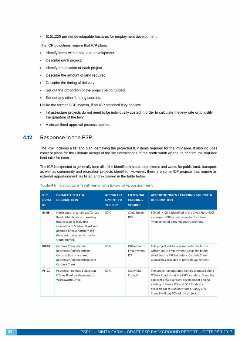
4.12 Response in the PSP
The PSP includes a list and plan identifying the projected ICP items required for the PSP area. It also includes concept plans for the ultimate design of the six intersections of the north south arterial to confirm the required land take for each.
The ICP is expected to generally fund all of the identified infrastructure items and works for public land, transport, as well as community and recreation projects identified. However, there are some ICP projects that require an external apportionment, as listed and explained in the table below.
Table 4 Infrastructure Treatments with External Apportionment
ICP
PROJ
ID
PROJECT TITLE &
DESCRIPTION
APPORTIO
NMENT TO
THE ICP
EXTERNAL
FUNDING
SOURCE
APPORTIONMENT FUNDING SOURCE &
DESCRIPTION
IN‐05 North‐south arterial road/Grices
Road: Modification of existing
intersection to including
truncation of Soldiers Road and
addition of new northern leg
(interim) to connect to north‐
south arterial.
50% Clyde North
DCP
50% of IN‐05 is identified in the Clyde North DCP
as project RD09 which refers to the interim
intersection of a roundabout treatment.
BR‐01 Cardinia Creek shared
pedestrian/bicycle bridge:
Construction of a shared
pedestrian/bicycle bridge over
Cardinia Creek.
50% Officer South
Employment
ICP
This project will be a shared with the future
Officer South Employment ICP as the bridge
straddles the PSP boundary. Cardinia Shire
Council has provided in principle agreement.
PS‐01 Pedestrian operated signals at
O'Shea Road on alignment of
Wordsworth Drive.
50% Casey City
Council
The pedestrian operated signals proposed along
O’Shea Road sits at the PSP boundary. Given the
adjacent area is already development and no
existing or future ICP and DCP funds are
available for this adjacent area, Casey City
Council will pay 50% of the project.

PSP11 – MINTA FARM – DRAFT PSP BACKGROUND REPORT – OCTOBER 2017 33
5 VISION AND PRICIPLE OF THE MINTA FARM PSP
5.1 Vision for the Minta Farm Precinct
The Minta Farm precinct will be home to a vibrant and integrated residential and employment community. The precinct’s character will be established through incorporation of the existing and unique natural and built features. Most notable will be the creation of a high amenity and integrated park network designed with the landscape and the remarkable constructed and natural waterway network along Cardinia Creek that is rich in biodiversity. The residential areas and regionally significant employment hub will be integrated by the town centre, will draw upon the natural topography and be connected by convenient transport links and a cohesive network of public spaces.
The precinct is projected to accommodate a residential population of approximately 8,000 people (in approximately 2,850 dwellings) and provide for approximately 11,000 local jobs.
5.2 Principles for the Plan
The key principles guiding the preparation of the PSP are:
5.2.1 An integrated residential and employment population.
Whilst the residential and employment catchments sit at opposing sides of the PSP area, the integration of the population will be encouraged through the centrally located town centre, extensive open space network and convenient transport connections.
5.2.2 Plan for local employment creation.
Planning policy identifies a shortfall in the local job provision. The regionally significant employment hub planned for the PSP area will provide much needed local jobs and allow residents to work close to home.
5.2.3 Plan for an urban structure that draws upon and maximises the natural features.
Residential uses have been located in the west of the precinct to make use of the undulating and attractive topography whilst employment uses are located on the flatter north-east portion of the PSP area abutting the unhospitable Freeway.
5.2.4 Create a diverse and vibrant new community.
The mixed residential and employment population will create a diverse community for the Minta Farm area. This will be further facilitated by the range of residential densities identified across the PSP area, designated according to surrounding land uses. Providing for a range of lot sizes and thereby housing types, it is anticipated that the PSP area will attract and accommodate a diverse population.
5.2.5 Integrate transport and land use planning.
As a first principle to transport planning, the PSP plans for an arterial road and connector street network that provides a well-spaced grid that connects to the wider network. In consideration of the precinct being an infill and providing key road links for the wider network, the PSP includes staging for the delivery of the road network. The staging balances the demand generated by the PSP versus the wider network.
Alternative transport modes are accommodated across the planned grid network, and combined with the relatively compact PSP area, will enable residents to reach key destinations by walking or cycling.

34 PSP11 – MINTA FARM – DRAFT PSP BACKGROUND REPORT – OCTBOER 2017
5.2.6 Plan for environmental sustainability.
Key environmental sustainability features of the PSP relate the compact urban structure. The residential densities designated according to walkable catchments, the extensive alternative transport network and access to local jobs and community facilities will collectively reduce dependence of private vehicle use.
5.2.7 Create a sense of place and community pride.
The existing features of the PSP area are key to creating a sense of place for the new community. These features, such as the district park, the Myer House and the conservation area, will be key to building a new community identity. A sense of place will be further established by the character and built form of the town centre and community hub.
5.2.8 Protect biodiversity, waterways and cultural heritage values.
The PSP area is rich in biodiversity and heritage values. The Cardinia Creek corridor and the remarkable adjoining constructed lake system is a unique environmental feature for the area that also holds significant aboriginal heritage value. This is complemented by built environmental values of the Myer House. The PSP identifies the conservation of these features and guides their appropriate integrated into the future urban structure.
5.2.9 Create integrated open space networks
Existing natural features provide excellent opportunities for creating integrated open space networks. Most prominently these exist in the western portion of the precinct, which can then be extended east and into adjoining residential areas.
5.2.10 Ensure the efficient and orderly provision of infrastructure and services
The PSP plans for the efficient and orderly provision of infrastructure and services. These are planned in accordance with required provision ratios, staged with development and with funding streams nominated.

PSP 11 Minta Farm Background Report October 2017