MINING RECLAMATION IN NORTH AMERICA - … · In North America, our mining operations are in...
28
MINING RECLAMATION IN NORTH AMERICA Supporting A Sustainable Future
Transcript of MINING RECLAMATION IN NORTH AMERICA - … · In North America, our mining operations are in...
MINING RECLAMATION IN NORTH AMERICA
Supporting A Sustainable Future

As a premier natural resource company headquartered in Phoenix, Arizona, we operate large, long-lived, geographically diverse assets around the world.
In North America, our mining operations are in Arizona, Colorado and New Mexico. We operate seven open-pit copper mines in the United States – Morenci, Sierrita, Bagdad, Safford and Miami in Arizona, and Tyrone and Chino in New Mexico. In Colorado, we conduct molybdenum mining operations at the Henderson underground mine and the Climax open-pit mine.
We produce metals to meet society’s needs with a commitment to sustainable development, part of which includes the land reclamation process. This process involves taking land once used in mining operations and converting it into alternate land uses.
With an eye toward the future, we focus on sustainable development today as a common thread that runs through all that we do.
TABLE OF CONTENTS 1 Introductory letter 2 What is Reclamation? 4 Reclamation in Colorado 10 Reclamation in Arizona 16 Reclamation in New Mexico 20 Vegetation Growth on Completed Reclamation Projects 21 Researching Tomorrow’s Reclamation Today 24 Enhancing Wildlife Habitat and Biodiversity 25 The Bigger Picture – Sustainable Development
The reclaimed Galena stockpile in Bisbee, Arizona, reflecting new vegetation growth in 2012.
Cover photo: Reclaimed land in Colorado at the historic URAD molybdenum mine.

1
Dear Reader,A sustainable future is a common commodity that benefits everyone. At Freeport-McMoRan, werecognize this and work every day to meet the needs of today’s modern society while minimizingenvironmental impacts to safeguard future generations.
We review and take account of the environmental effects and social/community impacts of our activities, whether exploration, mining or processing. We plan and conduct the design, development, operation and closure of each facility in a manner that optimizes the economic use of resources while working to reduce adverse environmental and social impacts.
As part of our commitment to the communities where we operate, we focus on comprehensive and long-term sustainable social development. This means engaging in an ongoing dialogue with communities and ensuring they are empowered to manage the economic, social and environmental factors well in advance of actual closure. Our Community Partnership Panels, comprised of local leaders and citizens representing a broad range of stakeholder groups across all sectors of the community, are designed to identify, plan and prioritize each community’s issues and develop strategies to create a sustainable future.
Also important for ensuring a sustainable future is honoring our commitment to environmental sustainability. We recognize not all environmental effects can be completely mitigated, although a key focus of our reclamation efforts is to re-establish wildlife habitat on impacted areas. The implementation of our reclamation projects is very much integrated with our community engagement. Where feasible, we work to create land use that coincides with community sustainability objectives established through our engagement efforts, particularly with the Community Partnership Panels. Potential use for reclaimed land, while typically viewed as wildlife habitat, could also include economic purposes, such as a renewable energy facility; for K-12 educational purposes such as an outdoor science lab; or recreational purposes like hiking or wildlife/bird watching. Economic and education initiatives tend to be the two highest priorities set by the Community Partnership Panels for their sustainability objectives.
To address our environmental commitment, a team of project managers, technical experts and equipment operators are currently executing projects to reclaim areas no longer required for current or future operations. Today’s reclamation process includes preventative work to address and mitigate the need for remediation later. Remediation involves capping, removing, reducing or treating contamination at a site to address residual environmental impacts. Additionally, Freeport-McMoRan created a program to identify and safely close abandoned mine features within its property boundaries without causing excessive disturbance to the surrounding environment and wildlife. Those projects and completed reclamation projects are highlighted in this document.
Thank you for your interest in what we do. We hope this booklet helps provide an understanding of our mining reclamation efforts as part of our commitment to a sustainable future.
Best regards,
William Cobb
Vice President, Environmental Services and Sustainable Development

2
WHAT IS RECL AMATION? Mining reclamation can take on various forms and achieve different objectives in an attempt to mitigate environmental impacts of mining and restore land that has been mined to a natural or semi-natural state. In some cases, existing drainages are incorporated into the reclamation plan to receive clean stormwater runoff from reclaimed mine facilities. Dormant habitats are being re-established. New landscapes also open up the potential for future recreation opportunities.
Today, the preparation and planning of mine reclamation activities occur prior to a mine being permitted and are a standard part of modern mining practices. During the hardrock mining process, tailings impoundments and rock stockpiles are typically generated. Tailings are the sandy residual sediments that remain after extracting mineral of economic value from the ore. After the mineral has been removed, the remaining materials are discharged to a storage area called a tailings impoundment or storage facility on the surface near the mine. Rock stockpiles (including mine overburden) may contain low concentrations of sulfide and/or oxide minerals and are managed for possible future mineral recovery, but may also be suitable for reclamation or other projects depending on economics and technological improvements.
Reclamation of the Robinson Tailings Pond in Colorado. Clockwise from top left: tailings are capped with waste rock or overburden from our Climax molybdenum mine; a blend of biosolids and lime are blended into the cap material; surface is ripped and prepared for seeding to encourage vegetation growth.

3
Once tailings facilities and rock stockpiles are no longer needed in an operation, they can be reclaimed. Reclamation takes into account surface and ground water and air quality, erosion concerns from stormwater, revegetation of suitable plant species and designing/providing wildlife and/or aquatic habitats.
The reclamation process generally includes re-sloping and contouring of the impacted areas, ensuring drainage channels are created to divert stormwater and limit percolation, establishing points for stormwater to discharge into existing drainages, capping the area with soil, and reseeding with native grasses and shrubs to encourage revegetation and promote wildlife habitat.
Reclamation sometimes involves removing old mining facilities, including mineral processing plants, shops and other structures, in addition to conducting additional technical studies to further refine mine closure/closeout activities. To address safety concerns, we close old mine openings, such as shafts or adits, that were created decades ago as early miners explored for metals. Today, approximately one third of these old structures are inhabited by bats, so we leave openings for the bats while keeping people out. To find out more about our bat conservation efforts, see page 24.
Work in process to cover tailings dams at our Chino mine in New Mexico.
Heavy earthmoving equipment regrading the #1 slag pile in Miami, Arizona.Reclamation team members in Bisbee, Arizona.
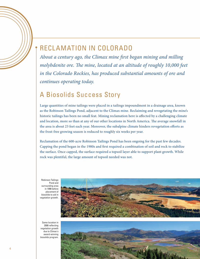
A Biosolids Success StoryLarge quantities of mine tailings were placed in a tailings impoundment in a drainage area, known as the Robinson Tailings Pond, adjacent to the Climax mine. Reclaiming and revegetating the mine’s historic tailings has been no small feat. Mining reclamation here is affected by a challenging climate and location, more so than at any of our other locations in North America. The average snowfall in the area is about 23 feet each year. Moreover, the subalpine climate hinders revegetation efforts as the frost-free growing season is reduced to roughly six weeks per year.
Reclamation of the 600-acre Robinson Tailings Pond has been ongoing for the past few decades. Capping the pond began in the 1980s and first required a combination of soil and rock to stabilize the surface. Once capped, the surface required a topsoil layer able to support plant growth. While rock was plentiful, the large amount of topsoil needed was not.
RECL AMATION IN COLORADOAbout a century ago, the Climax mine first began mining and milling molybdenite ore. The mine, located at an altitude of roughly 10,000 feet in the Colorado Rockies, has produced substantial amounts of ore and continues operating today.
4
Robinson Tailings Pond and
surrounding area in 1998 before placement of
biosolids to aid in vegetation growth.
Same location in 2008 reflecting
vegetation growth due to Climax's award-winning
biosolids program.

5
SpotlightClimax Molybdenum Company biosolids program was the recipient of the 2001 U.S. Environmental Protection Agency’s Exemplary Biosolids Management Award. The recognition was given for outstanding use of biosolids to help rehabilitate large-scale, high-altitude mine sites. Climax also received an award for outstanding reclamation in 2003 from the Colorado Division of Minerals and Geology for the same program.
By the 1990s, the explosive growth of resort communities in the local region created an increase in biosolid production. In addition, ski trail expansion and booming construction generated extra quantities of wood residuals. Local wastewater-treatment districts were in need of a new response to biosolid management in conjunction with the need to dispose of wood residuals. Likewise, biosolids offered a cost-effective alternative for the organics and nutrients necessary for successful reclamation at the Climax mine.
In 1996, Climax established a pilot demonstration project for the use of biosolids in reclamation. Today, the biosolids and woodchips are mixed and composted on site to produce over 30,000 cubic yards of growth medium for reclamation each year. The high quality of the biosolids used at Climax meets all state and federal regulatory standards.
Climax has now reclaimed much of the land along Highway 91 and has planted numerous spruce, fir, aspen and willow tree saplings. Though the tough climate of the area affects our success, the results-to-date suggest Climax’s reclamation program can establish diverse, permanent vegetation communities capable of sustaining wildlife habitat.
BEFORE
AFTER

6
SpotlightDue to the success of this stream channel restoration, Climax Molybdenum Company was recognized with its Excellence in Reclamation Award by the state of Colorado in 2010 for the Upper Arkansas River drainage reconstruction, reclaiming the surface impacted by historic mining activities and establishing a creek and a pond.
RECL AMATION IN COLORADO
A Stream Channel RestoredThe Climax mine is also at the headwaters of three major river basins: the Arkansas River, the Eagle River and Tenmile Creek.
Due to past Climax mine activities, the East Fork of the Arkansas River had been buried under mine overburden and rerouted through a 7-foot diameter concrete culvert. The culvert returned the river to a channel to flow into a native channel downstream of the mine property.
Climax undertook a project to reconstruct a new riverbed to a more natural state. This project entailed the design and construction of approximately 2,000 feet of restored stream channel and 14 acres of the contiguous watershed through the historic Storke Yard of Climax.
Stream channel restoration, habitat construction and revegetation activities are particularly difficult at the site as a result of the high altitude, short growing season, harsh winters, intense summer thunderstorms, periodic flood events and poor soils.
Restored Arkansas River channel across Storke Yard.
Pond feature along restored Arkansas River channel.

7
AbAndoned Mine lAndS
In an effort to help address the environmental issues that remain at historic hardrock mine sites in central Colorado, Freeport-McMoRan has committed to approximately $2.5 million over five years to assist the Colorado Inactive Mine Reclamation Program (CIMRP). This financial commitment, which began in 2012, will help the CIMRP leverage these funds to seek additional reclamation funds from multiple government agencies and nonprofit environmental organizations for work on abandoned mine lands. As a result of our commitment to this effort, the Colorado Division of Reclamation, Mining and Safety provided Freeport-McMoRan with its “Excellence in Hard Rock Reclamation” award at a ceremony in February 2013. In addition, as of 2012, we have established a multi-year partnership with Trout Unlimited to further address environmental issues in abandoned mine lands in Colorado.
The stream channel design was developed to maintain floodplain connectivity, mimic natural topography and pass stormwater runoff through a restored stream to establish aquatic wildlife habitat as part of a viable, self-sustaining ecosystem in the extreme climate of this region.
With construction of the stream channel completed in 2007, adjacent ridges and valleys were formed throughout the disturbed area. Floodplains and wetlands were constructed adjacent to the channel, providing habitat for riparian and wet meadow species.
Revegetation activities began soon after using composted biosolids from Climax’s award-winning biosolids program. Wetland and upland seed mixes were developed for the site. Several hundred new trees have been planted in the reclaimed area, as well as transplanted from adjacent areas, to contribute to the area’s structure and diversity.
Channel excavation in the Storke Yard at Climax in 2007. The Storke Yard previously served the Climax mine for underground mine support.
Fully revegetated meadow shown in 2012. The reconstructed channel winds through the right hand side of this restored mine disturbance.

8
RECL AMATION IN COLORADO
Reclamation of Legacy MinesReclamation work was also done in areas that were not directly associated with the Climax mine itself. This includes Searle and Kokomo gulches which had numerous legacy mines in what was considered the Tenmile mining district. These historic silver, lead, zinc, gold and copper mines were incorporated into the Climax mine property in the consolidation of its land base during the 1980s. Climax voluntarily initiated a project to remove and reclaim old waste rock piles in the Tenmile mining district. As of December 31, 2013, 41 historic mine sites have been cleaned up and 37 have been completely reclaimed. Nearly 227,000 cubic yards of waste rock and soils were removed and 50 acres of land were restored.
Historic mine site near Timberline in Kokomo gulch. Flagging shows locations of mine shafts.
Waste rock at the Lower Michigan mine before removal. Reclaimed Lower Michigan mine following removal of acid generating waste rock.
Same site after placement of soil cover, seed and mulch.

9
An Innovative ApproachDiscovered in 1910, URAD was mined from 1915 to 1974. Mine geology pointed to an ore body that would later become the Henderson mine. As Henderson was being developed, rock was removed and then used to reclaim the nearby URAD site. In the 1970s, the URAD Valley Reclamation Project was unprecedented — the first of its kind at such a high altitude — and received state and national recognition for its innovative approach. More than four decades after it won awards for environmental stewardship of the historic URAD mine, Climax Molybdenum Company initiated a project to enhance the habitat for a state endangered species known as the boreal toad. We support scientific research on the boreal toad population present on the reclaimed tailings.
At URAD, the tailings impoundments were built – pipelines embedded below the tailings that route water from one side of the impoundment to another – to convey water from Woods Creek located in the valley. However, Freeport-McMoRan has determined that decant structures can pose a tailings dam failure risk; in response, we are undertaking a project to close the decant structure and reroute water. Closure efforts of the concrete pipes underneath the tailings pond were initiated by creating a channel on the surface. The project included the creation of riparian habitat along the new channel, as well as the development of a pond established for the benefit of the boreal toad.
Spillway routing Woods Creek adjacent to lower URAD tailings impoundment.
Reconstructed Woods Creek channel across lower URAD tailings impoundment. Boreal toad, a state-endangered species that occurs in Woods Creek Valley.

10
RECL AMATION IN ARIZONA For over a century, copper mining in Arizona has been a source of growth and economic prosperity. Mining practices have evolved over time and now include the objective of a post-mine-life land-use.
With more information and advancements in technology, mining reclamation takes into account environmental stewardship and aesthetics more than ever. We have undertaken major reclamation projects to mitigate the impacts of past mining eras, even as we have developed new mines that meet the latest environmental and land-use standards.
Reclaimed Galena stockpile in Bisbee, displaying a historic headframe used during mining operations.

11
Capping an Enduring and Pioneering Period in BisbeeAt Bisbee, underground mining began in 1880 and continued with little interruption until all activities ceased in 1975. When open-pit mining began in 1954, rock stockpiles were built and tailings from various milling activities were deposited. Since 2006, we have undertaken major reclamation projects to mitigate areas impacted by mining disturbances. These efforts are ongoing with teams of reclamation crews and environmental experts working on major voluntary reclamation projects that encompass approximately 1,100 acres.
Part of this major voluntary effort involves reclamation projects at several rock stockpiles in the Bisbee area, known as the ‘C’ Canyon, Cole, Dallas, Galena and South Bisbee stockpiles. These stockpiles were historically sources of acid-rock drainage during summer and winter storm events. The work included grading, capping and replanting vegetation with the goal of improving visual aesthetics, eliminating acid drainage that otherwise required collection and management, and creating wildlife habitat.
RECL AMATION IN ARIZONA
Stockpile reclamation in process on one of the slopes in South Bisbee as of 2013. 11

12
New surface drainages will be installed to manage and introduce unimpacted stormwater runoff back into the natural environment for aquifer recharge. Approximately 3 million cubic yards of material will be moved just to recontour and cover the South Bisbee stockpile.
In 2011, reclamation work began on the Bisbee-area tailings impoundments and adjacent facilities. The tailings project reclamation area, which lies immediately south of Bisbee near Highway 92, includes the North and South tailings impoundments, the Crawford mill concrete sub-structures and diesel power plant, and Horseshoe Basin. As part of this voluntary reclamation process, Freeport-McMoRan re-graded the side and top surfaces of both impoundments and covered them with approximately 2 feet of clean material to effectively manage stormwater and ensure it is discharged in a way that promotes replenishment of the local watershed.
Tailings dams are typically designed and constructed with a large top surface footprint to facilitate long-term tailings deposition and reclaim water collection. One of the most difficult aspects of designing a reclamation project is dealing with high intensity or peak storm events that produce extreme runoff flows over a short period of time. The quick release of these large stormwater runoff flows is critical for reclaimed tailings impoundments to reduce the amount of water that can infiltrate into the tailings material becoming long-term seepage that must be collected. In order to meet runoff and infiltration goals, past tailings reclamation projects required significant amounts of new material to be hauled and placed in order to provide positive drainage from the top surface of the large dam areas toward off-site conveyance. In addition, rapid draining of peak storm events typically produces extreme stormwater runoff flows to be conveyed off-site, which can create off-site erosion issues.
The former Crawford mill and diesel power plant area after reclamation.
Photo inset: Prior to reclamation
(reverse angle).
Reclamation work in progress on one of the slopes.

13
Spotlight
The approach for the Bisbee tailings dam reclamation project was to develop design concepts that would decrease re-grading of the top surfaces with imported material while reducing the need for conveyance structures required to handle peak storm water runoff flows. The Bisbee design concept utilizes the current grading of the dam and the large top surface area to capture storm water runoff from specific areas of the dam and reduce the peak flow as it is conveyed off the top of the dam into an off-site conveyance. This new concept attenuated peak flows by nearly 10 times, when compared to a conventional design, to around 120 cubic feet per second. In addition, the basins are lined to provide low net infiltration of precipitation.
As an extra benefit to this new design, the addition of lined attenuation basins on the top surface produces a different type of ecosystem than would typically exist otherwise. The basins are designed not only to reduce large flows, but also to capture low flows. These attenuation basins function in essence as “engineered playas,” with wet and dry cycles based on rainfall and time of year. In an average year, depending on rainfall, there may be standing water in these basins for as much as six months. The "engineered playas" do replenish and overflow to our discharge downdrain during monsoon season. Therefore, when it comes to potential accumulation of natural minerals derived from the cover material and/or the vegetation, they are somewhat “self cleaning.” Since this water is coming from reclaimed land, the water quality is as good as surface water reporting off site, attracting a variety of birds, animals and insects, thus creating a more bio-diverse reclaimed area. Performance monitoring with this new test reclamation design centered on infiltration, erosion, vegetation and eco-system functionality goals is currently underway. The concept may be used for future tailings reclamation projects that have a much larger footprint than Bisbee.
Reclamation of North (right) and South (left) tailings impoundments as of 2013.
13

14
RECL AMATION IN ARIZONA
Conducting Reclamation Concurrently with Mining at Miami The historic mining town of Miami is home to an open-pit copper mine, operating smelter and rod mill, our only operation of this kind. A limited future mine-life at Miami has produced an effective operational synergy between mining operations and reclamation activities, which includes ways to enhance the area for both the community and wildlife after the mine reaches end-of-life. This synergy leads to a promising future for Miami operations and reclamation projects. For example, the large-scale rock stockpile and tailing reclamation effort at Miami covers approximately 1,000 acres. Much of the waste material being mined to develop the ore body is quality cover material used for rock stockpile and tailings reclamation purposes.
Understanding the age of the Miami district is important because as mining increased, the areas used to convey stormwater runoff were closed off by either rock stockpiles, tailings dams or mine pit development. Continuing reclamation at Miami will include a substantial amount of stormwater runoff attenuation to provide the ability to meter water on a controlled basis into the existing off-site drainages around the Miami area.
The Webster Lake project at Miami uses reclamation to significantly reduce the amount of mine impacted water that must be managed by the site. The benefit coincides with the restoration of a stream channel capable of conveying unimpacted stormwater runoff from the reclamation areas off site. This natural drainage has not been “free draining” since the 1930s, making it a significant step for Miami reclamation and one of the largest reclamation projects conducted by Freeport-McMoRan. The designs utilize shallower slope angles and more controlled stormwater runoff in a variation of the Bisbee tailings dam reclamation design. The unimpacted runoff will be directed off-site to help remediate the Bloody Tanks and Pinal Creek stream channels.
BEFORE: Webster Lake area in 2008. AFTER: The reclaimed Webster Lake area; progress as of 2013.
14

Wildlife And biodiverSity in globe-MiAMi
Across our company we have undertaken efforts to enhance local habitat and protect wildlife species. One example is in Globe-Miami, where land and water resources controlled by our Miami operations are utilized to promote the sustainability of local habitat and wildlife. Some of these current endeavors include:
• A pollinator landscape to promote propagation of pollinating species such as birds, bees and butterflies.
• Raptor protection on all new power lines and poles and on existing power lines and poles when shut down for major refurbishments.
• A migratory bird habitat, including a pond.
• Watering areas cleaned and upgraded with a clay liner material to prevent seepage and conserve stormwater.
• A coordination with local schools in using created habitats as outdoor science labs.
For more on our North American wildlife and biodiversity efforts, please see page 24.
Another one of Miami’s reclamation projects involves the removal of more than 8.2 million cubic yards of material from historic stockpiles to other areas of the mine in order to reshape and revegetate areas closer to town. These stockpiles, known as the Davis Canyon and Live Oak stockpiles, cover 120 surface acres and 8 acres of evaporation ponds. The Davis Canyon #5 and #16 stockpiles will have their vertical and horizontal slopes re-graded and will have wide benches. The benches will also act as surface water channels to intercept/divert surface water from the top and sides slopes of the re-graded stockpile in an effort to reduce erosion. Water will flow into holding ponds to be used as needed for mining operations. Any excess water will be released into their ancestral drainage areas. Approximately 334,000 cubic yards of soil, roughly 2 feet deep throughout, will cover the newly re-graded slopes to help with stormwater management, to enhance the landscape and to provide for wildlife habitat.
Cattle used on reclaimed land in Miami act as natural organic soil builders to aid
in vegetation growth.
15

16
RECLAMATION IN NEW MEXICO
With large-scale mining operations dating to the early 1900s, our New Mexico operations have produced significant quantities of copper over time. Even as our Chino and Tyrone mines continue to produce copper, reclamation has been completed on tailings areas no longer needed for future operations, and is either planned or underway for unused rock and leach stockpiles. We also have reclaimed the former Chino smelter footprint and are currently reclaiming former process and slag areas.
16
Aerial photo of all three Tyrone tailings dams. Reclamation work was performed from approximately 2003 through 2009.

17
SpotlightAs a result of the extensive reclamation work at Tyrone, Freeport-McMoRan was honored with the 2012 Excellence in Reclamation Award by the Mining and Minerals Division of the New Mexico Energy, Minerals and Natural Resources Department.
Progress, Success at TyroneAt the Tyrone mine, old tailings impoundments and rock stockpiles have been undergoing major changes since 2004. Tailings were produced from 1969 until 1992 and were deposited within six large impoundments north of the mine.
In total, approximately 4,400 acres at Tyrone have been reclaimed as of mid-2013 – close to half of the original mining disturbance. The reclamation work at Tyrone is the largest scale hardrock reclamation in the State of New Mexico and rivals the scale of any other hardrock mining reclamation in the United States that we have found for comparison. Reclamation has also been completed while continuing active mining operations.
Additionally, we have removed old mining facilities including mineral processing plants, shops and other structures that are not needed for current copper production.
As a first step in the tailings reclamation process, earthmoving equipment was utilized to grade side slopes on the impoundments, preparing them for capping with soil and developing stormwater diversions. Diversions are critical to ensure there is no excessive ponded water and to limit infiltration. In addition, the designs limit erosion of cover materials. The entire area was then reseeded with native grasses and shrubs, with a plan to create a wildlife habitat for post-mining land use. Today, native grasses can be seen growing on areas that were once barren, white-colored tailings. Mule deer and elk have been spotted roaming the reclaimed surface.
Erosion resistant cover materials in use at Tyrone. Stormwater channel armoring includes riprap, concrete block, grade controls, self-armoring materials and roller-compacted concrete.

18
Mining Reclamation at Chino – Anything but RoutineOriginally mined by Native Americans and later by Spaniards, Chino began open-pit mine production in 1910. Since then, tailings deposition has covered almost 3,000 acres. Large-scale tailings reclamation began in 2008 on about 2,000 of these acres no longer required for current or future operations. The remaining Chino tailings will be reclaimed whenever concentrator operations and tailings production end.
The reclamation work began with pipelines and power lines moved from the top of old structures. Side slopes on the impoundments were reduced and prepared for capping with soil and the development of stormwater diversions.
Once capping is complete, the entire area will be reseeded with native grasses and shrubs to support wildlife habitat.
RECL AMATION IN NEW MEXICO
Six different tailings dams were combined for reclamation purposes. Reclamation began in 2008 and will be completed in 2014. An active tailings pond is visible in the upper right corner of the photo.
18
19
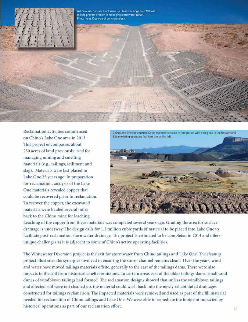
Reclamation activities commenced on Chino's Lake One area in 2013. This project encompasses about 250 acres of land previously used for managing mining and smelting materials (e.g., tailings, sediment and slag). Materials were last placed in Lake One 25 years ago. In preparation for reclamation, analysis of the Lake One materials revealed copper that could be recovered prior to reclamation. To recover the copper, the excavated materials were hauled several miles back to the Chino mine for leaching. Leaching of the copper from these materials was completed several years ago. Grading the area for surface drainage is underway. The design calls for 1.2 million cubic yards of material to be placed into Lake One to facilitate post-reclamation stormwater drainage. The project is estimated to be completed in 2014 and offers unique challenges as it is adjacent to some of Chino’s active operating facilities.
The Whitewater Diversion project is the exit for stormwater from Chino tailings and Lake One. The cleanup project illustrates the synergies involved in ensuring the storm channel remains clean. Over the years, wind and water have moved tailings materials offsite, generally to the east of the tailings dams. There were also impacts to the soil from historical smelter emissions. In certain areas east of the older tailings dams, small sand dunes of windblown tailings had formed. The reclamation designs showed that unless the windblown tailings and affected soil were not cleaned up, the material could wash back into the newly rehabilitated drainages constructed for tailings reclamation. The impacted materials were removed and used as part of the fill material needed for reclamation of Chino tailings and Lake One. We were able to remediate the footprint impacted by historical operations as part of our reclamation effort.
Articulated concrete block rises up Chino's tailings dam 700 feet to help prevent erosion in managing stormwater runoff. Photo inset: Close-up of concrete block.
Chino Lake One reclamation. Cover material is visible in foreground with a slag pile in the background. Some existing operating facilities are on the left.

20
Vegetation Growth on Completed Reclamation Projects.Clockwise from top left: the Copper Basin stockpile near Prescott; bucks grazing on reclaimed stockpile land in New Mexico; the Clarkdale tailings near Tuzigoot National Monument; and reclaimed legacy site in Colorado.

21
VegetationBy studying different forms of vegetation, we aim to better understand the response and establishment of vegetation on reclaimed land. This involves research to learn site-specific criteria for improving revegetation efforts on reclaimed land relative to species planted as well as the timing and method of planting.
Currently, annual surveys are conducted at six different sites in Arizona. Surveys include collecting data on species present, species frequency, vegetation density, canopy cover and vegetation changes over time. In addition to studying vegetation dynamics on reclaimed land, native undisturbed comparable sites are also evaluated annually. By studying areas with similar soils, we seek to create seed mix that may enhance revegetation efforts.
Quality assurance testing is performed to ensure seeding follows the prescribed application rate. During reclamation, once soil cover is down, mulch is placed on top, then seeded.
Workers analyze a mechanical erosionometer, which measures surface topography changes over time. This helps monitor success of existing cover material in mitigating erosion. Laser erosionometers are also utilized.
ErosionOur research on erosion is designed to help us gain knowledge of where, how and why erosion occurs and utilize this information to improve our site-specific design and construction specifications. This takes into account the soil type, slope angle, slope length, surface management methods (such as seeding techniques) and other various best management practices. Part of this process involves understanding the various technologies capable of monitoring erosion, the limitations of the technology and the practicality of the technology.
RESEARCHING TOMORROW'S RECL AMATION TODAYWhile busy with ongoing reclamation activities throughout the Southwest, our team is also studying ways to enhance reclamation processes for tomorrow. Research projects on vegetation, erosion, landscape function and soil/rock covers are underway to better understand what tomorrow’s reclamation efforts may entail.

22
A worker analyzes a variety of cover material to determine which samples best aid with vegetation. Each bag represents 2 feet of material drilled from different locations. Certain plants have greater success with specific cover material.
Cover Material TechnologiesOne of the primary ways Freeport-McMoRan applies source control measures on reclaimed lands is through soil covers. Many different soils have been utilized during reclamation efforts. Alluvial desert soils, glacial moraines, metasediments, conglomerates and run-of-mine volcanics are a few of the different soils utilized in reclamation to meet site-specific performance criteria. In addition to soils, composted biosolids are utilized in combination with run-of-mine rock to create a growth media for plant establishment. These cover materials are monitored for their performance with respect to erosion resistance (slope angle and length), vegetation success (type of species and density) and overall source control capabilities.
Before and after photos evaluating alternative cover material. Rock capping is tested for resistance to erosion, vegetation success and limiting water infiltration. In these 2012 photos, cover material was applied in February, seeded in June and vegetation growth reflected as of September.
Evapotranspiration (ET) cover systems are designed to store and release water from precipitation events. ET cover systems limit net percolation of water by storing it for evaporation and transpiration through vegetation. These covers are traditionally constructed with soils, which support vegetation and are resistant to erosion. Soils used for creating the cover/cap system must meet strict construction specifications to ensure long-term performance metrics with respect to erosion resistance and limiting net percolation. The ET cover systems utilized in mine reclamation projects require large volumes of soil in proximal locations. Mine reclamation projects rely on cover systems to adequately separate mine waste from the surrounding environment.
Numerous mine sites around the world have limited quantities and access to soils which meet site-specific cover system specifications. Freeport-McMoRan implemented a new cover technology utilizing large-sized waste rock as an alternate cover material at the Morenci mine site in 2012. We plan to evaluate the performance of this rock cover system over a 10-year period.

2 3
Mule deer graze on reclaimed land in New Mexico.
A bear sits on the tailings dam in New Mexico.
A review of surface hydrology indicators is part of our landscape function analysis. Assessing the functional status of land helps us determine the soil aggregate stability to aid in vegetation.
Landscape FunctionWe study landscape function in an attempt to bring the issues of surface stability and revegetation together to be viewed as an inclusive effort rather than as separate functions. Landscape Function Analysis (LFA) is a qualitative method of monitoring the development of vegetation cover and other functional attributes of reclaimed and rehabilitated lands. It is based on the concept that vegetation, litter, rock cover and soil properties control the degree to which resources (water and nutrients) are captured rather than lost from a reclaimed area. Resource capture promotes the development of vegetation and thereby other components of a biodiverse ecosystem, such as soil microbes, invertebrates, insects and other animals.
Biodiversity StudiesReclaimed lands are monitored to ensure the newly created landscapes are operating as self-sustaining ecosystems and that these lands are meeting their post-mining land use. Vegetation monitoring and LFA monitoring are a few of the tools used for observing and managing reclaimed lands. Vegetation monitoring looks at the vegetation dynamics of the reclaimed areas and native landscapes (what is growing) and LFA assesses how well a reclamation area is functioning as a natural system. Data generated from these monitoring efforts allows for comparisons between reclaimed lands and native surrounding areas (reference sites). Reference sites represent mature native functional landscapes and provide target values for the final reclaimed landscape. Target values include landscape stability dynamics and three indices produced from LFA. For example, in Bisbee, five years of monitoring data indicates that the reclaimed mine lands are developing into a mature stable landscape comparable to the native surrounding landscape.
Our goal with this analysis is to improve our understanding of landscape evolution over time and to use the data as feedback mechanisms to improve reclamation efforts. LFA calculates three indices from the data collected — stability, infiltration and nutrients. At present, this method is deployed at two properties in Arizona that have reclaimed land and native undisturbed comparable land being monitored.
24
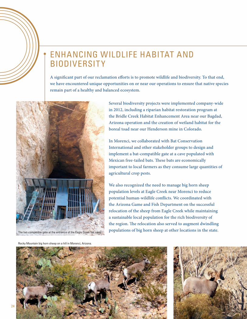
ENHANCING WILDLIFE HABITAT AND BIODIVERSIT YA significant part of our reclamation efforts is to promote wildlife and biodiversity. To that end, we have encountered unique opportunities on or near our operations to ensure that native species remain part of a healthy and balanced ecosystem.
Several biodiversity projects were implemented company-wide in 2012, including a riparian habitat restoration program at the Bridle Creek Habitat Enhancement Area near our Bagdad, Arizona operation and the creation of wetland habitat for the boreal toad near our Henderson mine in Colorado.
In Morenci, we collaborated with Bat Conservation International and other stakeholder groups to design and implement a bat-compatible gate at a cave populated with Mexican free-tailed bats. These bats are economically important to local farmers as they consume large quantities of agricultural crop pests.
We also recognized the need to manage big horn sheep population levels at Eagle Creek near Morenci to reduce potential human-wildlife conflicts. We coordinated with the Arizona Game and Fish Department on the successful relocation of the sheep from Eagle Creek while maintaining a sustainable local population for the rich biodiversity of the region. The relocation also served to augment dwindling populations of big horn sheep at other locations in the state.The bat-compatible gate at the entrance of the Eagle Creek bat cave.
Rocky Mountain big horn sheep on a hill in Morenci, Arizona.

25
THE BIGGER PICTURE – SUSTAINABLE DEVELOPMENTOur reclamation efforts are thorough and extensive, yet are only part of our commitment to the big picture – a sustainable future.
We strive to meet the needs of the present generation without compromising the ability of future generations to meet their own needs. We do so by focusing on the three components of sustainable development: economic security, social responsibility and environmental performance.
The safety of our workforce remains our number one priority and is part and parcel with our sustainable development objectives. And with safety at the forefront, we continually evaluate the most effective ways to manage environmental aspects at all of our operations. Our environmental work aims to meet or exceed federal, state and local requirements.
Our sustainable development efforts would not be achievable without the strong community relationships where we have a presence. Throughout our operations, direct community engagement is the cornerstone of identifying social development priorities and developing stakeholder trust.
Lastly, as part of a promising and sustainable future, we are advancing expansion projects while our significant exploration drilling programs continue to identify opportunities for future reserve and production growth – all to deliver metals that drive the world’s economies.
A duck wading through a wetland pond on a reclaimed tailings dam in Colorado's URAD Valley.
A bull elk on the reclaimed Robinson tailings pond.
A western kingbird resting on vegetation at Tyrone's reclaimed tailings dams.
A collared lizard as seen at Tyrone's reclaimed tailings dams.

MINING RECLAMATION IN NORTH AMERICA333 NORTH CENTRAL AVENUE PHOENIX, ARIZONA 85004 602 .366.8100
www.fcx.com
This report is printed on 100% post-consumer recycled paper.
This report is printed on Mohawk Options, 100% PC White, which is manufactured entirely with Green-e certified wind-generated electricity.