MINING PROPOSAL M70/1325 - Citizen Space · MINING PROPOSAL M70/1325 Pigeon - Haddrill Road Yanchep...
94
MINING PROPOSAL M70/1325 Pigeon - Haddrill Road Yanchep Extraction of Sand M70/1325 is held by Carew Nominees Pty and Ceptre Nominees Pty Ltd. M70/1325 is to be operated under authority by, and proposed by, PMR Quarries Pty Ltd trading as WA Limestone. The documentation is provided under the heading of WA Limestone WA LIMESTONE DEPARTI\/Ir i'JT QF I MINES AND PE [t:ÿ(.=)LEUM 10 June 2014 MINERALS TITLES DI\'rrsION W.A LIMESTONE Address WA LIMESTONE 401 Spearwood Avenue Bibra Lake WA 6065 PO Box 1404 Bibra Lake WA 6965 Phone 08 9434 7777 Ancillary Docld: Lodge Date: Lodge Office: Lead Tenement: 145704 10/06/2014 16:05:00 PERTH M 70/1325 em-a-145704
-
Upload
nguyentruc -
Category
Documents
-
view
223 -
download
0
Transcript of MINING PROPOSAL M70/1325 - Citizen Space · MINING PROPOSAL M70/1325 Pigeon - Haddrill Road Yanchep...

MINING PROPOSAL
M70/1325Pigeon - Haddrill Road
Yanchep
Extraction of Sand
M70/1325 is held by Carew Nominees Pty and Ceptre Nominees Pty Ltd.M70/1325 is to be operated under authority by, and proposed by,
PMR Quarries Pty Ltd trading as WA Limestone.The documentation is provided under the heading of WA Limestone
WA LIMESTONE
DEPARTI\/Ir i'JT QF IMINES AND PE [t:ÿ(.=)LEUM
10 June 2014
MINERALS TITLES DI\'rrsION
W.A LIMESTONE
Address WA LIMESTONE401 Spearwood AvenueBibra Lake WA 6065
PO Box 1404Bibra Lake WA 6965
Phone 08 9434 7777Ancillary Docld:Lodge Date:Lodge Office:Lead Tenement:
14570410/06/2014 16:05:00PERTHM 70/1325
em-a-145704

10 June 2014
Department of Mines and Petroleum100 Plain StreetEast Perth WA 6004
Attention Environment Division
Re M70/1326, Harrdill Road, YanchepM70/1325, Pigeon Road, Yanchep
The Mining Proposal and Mine Closure Plans are presented to support applicationfor
M70/1326, Harrdill Road, YanchepM70/1325, Pigeon Road, Yanchep.
It is noticed that when the tenement was applied for there was an error in the nameof one holder. The tenement register for both leases is therefore incorrect.
The Mining Proposal and Mine Closure Plans use the correct names. Bothdocuments contain a letter of authorisation for the preparation of the documentationfrom the tenement holders Carew Nominees Pty Ltd and Ceptre Nominees Pty Ltd, acopy of which is attached.
The tenement holders have authorised PMR Quarries Pty Ltd trading as WALimestone to prepare the documentation as they will be undertaking the excavation.
An amendment to the name on the tenement is being prepared.
Thankyou
//Lindsay StephensLandform Research ,/ÿ,
/
On behalf of PMR Quarries Pty Ltd Trading as WA Limestone forCarew Nominees Pty Ltd and Ceptre Nominees Pty Ltd
Lindsay Stephens BSc (Geology), MSc (Plant Ecology)
Mem Aus Geomechanics Soc - MEIANZ - FIO.A
25 Heather Road Roteystone WA 6111
Tel 9397 5145, [email protected]
MINING PROPOSAL
M70/1325 Pigeon - Haddrill Road
Yanchep
Extraction of Sand
M70/1325 is held by Carew Nominees Pty and Ceptre Nominees Pty Ltd. M70/1325 is to be operated under authority by, and proposed by,
PMR Quarries Pty Ltd trading as WA Limestone. The documentation is provided under the heading of WA Limestone
WA LIMESTONE
10 June 2014
Address WA LIMESTONE 401 Spearwood Avenue Bibra Lake WA 6065 PO Box 1404 Bibra Lake WA 6965 Phone 08 9434 7777

Mining Proposal -‐ Sand and Limestone Extraction, M70/1325, Pigeon -‐ Haddrill Road, Yanchep
Landform Research I
MINING PROPOSAL CHECKLIST (as per Appendix 6 in Mining Proposal Guidelines) M70/1325
No Mining Proposal checklist Y/N NA Page No Comments
Public availability 1 Are you aware that this Mining Proposal is publically
available? Yes
2 Is there any information in this Mining Proposal that should not be publicly available? No
3 If 'No' to Q2, do you have any problems with the information contained within this Mining Proposal being publicly available?
N/A
4 If 'Yes' to Q2, has confidential information been submitted in a separate document / section? N/A
5 Has the Mining Proposal been endorsed? (See last page Checklist) Yes
Mining Proposal Details
6 Have you included the tenement number(s), site name, proposal overview and date in the title page? Yes
7 Who authored the Mining Proposal? Landform Research
8 State who to contact for enquiries about the Mining Proposal? Landform Research
9 How many copies were submitted to DMP? Hard Copies = 1 Electronic = 1
10 Is this Mining Proposal to support lease application? Yes 11 Has a Geological Resource Statement been included (refer
section 4.3.2 of Mining Proposal Guidelines) N/A Basic Raw Material
12 Will more than 10 million tonnes of ore and waste be extracted per year? State total tonnage: No
13 Will more than 2 million tonnes of ore be processed per year? State total throughput: No
14 Is the Mining Proposal located on pre-1899 Crown Grant Land? (not subject to the Mining Act 1978) No
15 Is the Mining Proposal located on Reserve Land? If 'Yes' state Reserve types in space below: Yes
State Forest 65 Pine Plantation
16 Will the Mining Proposal occur within or affect a declared occupied townsite? No
17 Is the Mining Proposal within 2km of the coastline or a Private Conservation Reserve? No
18 Is the Mining Proposal wholly or partially within a World Heritage Property, Biosphere Reserve, Heritage Site or Soil Reference Site?
No

Mining Proposal -‐ Sand and Limestone Extraction, M70/1325, Pigeon -‐ Haddrill Road, Yanchep
Landform Research II
No Mining Proposal checklist Y/N NA Page No Comments
Tenement Details 19 Are all mining operations within granted or applied for
tenement boundaries? Yes
20 Are you the tenement holder of all tenements? No 21 If 'No' at Q20, do you have written authorisation from the
tenement holder(s) to undertake the Mining Proposal activities? (Refer to section 4.2.1 of the Mining Proposal Guidelines)
Yes
Atttached
22 If 'Yes' at Q21, then is there a copy of the authorisation contained within the Mining Proposal? Yes In the
Summary. 23 Have you checked for compliance against tenement
conditions? Yes
Location and Site Layout Plans
24 Have you included location plans showing tenement boundaries and mining operations? Yes
25 Have you included site layout plans showing all mining operations and infrastructure in relation to tenement boundaries?
Yes
26 Have you included Area of Disturbance Tables' for all tenements impacted by mining operations? Yes
Environmental Protection Act
27
Does the Mining Proposal require referral under Part IV or the MOU? If 'Yes' describe why in the space below:
Yes
Lies within State Forest 65 and proposed extension of the Yanchep National Park
Lies within the Lake Clifton Catchment
28 Has the EPA set a level of assessment? If yes state: No 29 Is a clearing permit required? If 'No' then explain why in
space below: Yes
30 If 'Yes' at Q29 then has a permit been applied for? No
The tenement is under application.
31 Is a Works Approval required by the DER (Formerly DoE)?
Yes
32
Has a Works Approval application been submitted to the DEC (Formerly DoE)?
No
Will be submitted prior to crushing limestone.
33 Stakeholder Consultation — Have the following
stakeholders been consulted? (use N/A if not applicable)
Shire? Yes Notified on application.
Pastoralist? N/A

Mining Proposal -‐ Sand and Limestone Extraction, M70/1325, Pigeon -‐ Haddrill Road, Yanchep
Landform Research III
DPaW Yes Notified on application
Main Roads? Yes Notified on application
Forest Products Commission Yes
Liaison and discussions
Traditional Owners Yes
Notified on application
34 Is the Mining Proposal wholly or partially within DPaW (formerly CALM) managed areas? No State Forest 65
35 If 'Yes' at Q34 has DPaW (formerly CALM) been consulted? Yes
36 Is the Mining Proposal wholly or partially within a Red Book Area or a Bush Forever Site? No
Adjacent to Bush Forever Site 381.
37 Will the Mining Proposal impact upon a Water Resource Area Water Reserve, declared or proposed catchment, Groundwater Protection Area, significant lake or wetland?
No
Will not impact but lies within the Gnangara Groundwater Area
38 Is a water or de-watering licence required? No Not necessary but has will be applied for.
39 If 'Yes' at Q38 then has the licence(s) application been submitted? No
40 Does the Mining Proposal include a new tailings storage facility or changes to existing tailings storage facility? No
41 Have waste characterisation assessments been undertaken (e.g. AMD, dispersiveness, salinity)? Yes Natural
materials only.
42 Have flora and fauna surveys been undertaken? Yes See Appendices
43 Are any rare species present? No TEC is present
and is excluded.
44 Has a Preliminary Closure Plan been included? Yes Attached


Mining Proposal -‐ Sand and Limestone Extraction, M70/1325, Pigeon -‐ Haddrill Road, Yanchep
Landform Research V
SUMMARY 1 1.0 BACKGROUND INFORMATION 4 1.1 Ownership 4 1.2 Project Objectives 4 1.3 Location and Access 6 1.4 Resource Sought 6 1.5 Site Layout 7 1.6 Existing Facilities 8 1.7 History 8 2.0 EXISTING ENVIRONMENT 9 2.1 Regional Setting 9 2.2 Geology - Geomorphology 9 2.3 Soils and Soil Profiles 10 2.4 Waste Rock and Tailings 10 2.5 Climate 10 2.6 Hydrology 11 2.7 Biodiversity 12 2.7.1 Flora 12 2.7.2 Fauna 17 2.8 Social Environment 20 2.8.1 Surrounding Landuse 20 2.8.2 Aboriginal Heritage 20 3.0 PROJECT DESCRIPTION 21 3.1 Disturbance Table 21 3.2 Mining Operations 23 3.3 Processing 25 3.4 Tailings Storage 25 3.5 Support Facilities 26 3.6 Workforce 27 3.7 Transportation Corridors 28 3.8 Resource Requirements and Regional Infrastructure 28 3.9 Compliance with Legislation and Other Approvals 28 3.10 Buffers 29 4.0 ENVIRONMENTAL MANAGEMENT 30 4.1 Land Clearing 30 4.2 Water 31 4.3 Flora, Fauna and Ecosystem 31 4.3.1 Flora 31 4.3.2 Fauna 32 4.3.3 Ecosystems 36 4.3.4 Wetlands 37 4.4 Topsoil and Soil Profiles 37 4.5 Domestic and Industrial Waste 38 4.6 Waste Rock and Tailings Management 38 4.7 Hydrocarbon Management 38 4.7.1 Fuel Storage 38 4.7.2 Fuel Spill Management Plan 38 4.7.3 Servicing and Maintenance 39 4.8 Dangerous Goods and Hazardous Substances 40 4.9 Atmospheric Pollution and Noise 40

Mining Proposal -‐ Sand and Limestone Extraction, M70/1325, Pigeon -‐ Haddrill Road, Yanchep
Landform Research VI
4.9.1 Dust 40 4.9.2 Noise 42 4.10 Vegetation Impacts 45 4.10.1 Vegetation Hygiene Management 45 4.10.2 Weed Management 47 5.0 SOCIAL IMPACTS 49 5.1 Heritage 49 5.2 Land Use and Community 49 5.3 End Use 53 5.4 Social Environment 53 5.5 Stakeholder Consultation 53 5.6 Workforce Induction and Training 55 6.0 SAFETY 55 6.1 Geotechnical Issues 55 6.2 Operational Safety 56 6.3 Fire Management 57 6.4 Site Security 57 7.0 MINE CLOSURE 58 7.1 Post Mining Landuse and Closure Planning 58 7.2 Disturbance 59 7.3 Closure Obligations 60 7.4 Identification of Management and Closure Issues 60 7.5 Development of Completion Criteria 61 7.6 Financial Provision for Closure 65 7.7 Closure Implementation 66 REFERENCES 74 FIGURES Figure 1 Regrowth of Scattered Native Vegetation Figure 2 Regrowth of Scattered Native Vegetation Figure 3 Vegetation Communities Figure 4 Location Figure 5 Proposed Excavation Footprint Figure 6A Existing Contours Figure 6B Concept Final Contours Figure 7 Typical Limestone and Sand Excavations Figure 8 Proposed Excavation Methods Figure 9 Aerial Photograph ATTACHMENTS 1 Mine Closure Plan 2 Flora Study – Mattiske Consulting 3 Fauna Study - Western Wildlife 4 Cockatoo Survey – Tony Kirkby 5 Department of Aboriginal Affairs Database Search 6 Concept Offset Plan – CO2 Australia 7 Dust Management Plan

Mining Proposal -‐ Sand and Limestone Extraction, M70/1325, Pigeon -‐ Haddrill Road, Yanchep
Landform Research VII
8 Water Management Plan 9 Minutes of Discussions with CALM (DPaW) and DMP.
Prepared by Lindsay Stephens BSc Geology), MSc (Plant Ecology) 25 Heather Road Roleystone WA 6111 Mem Aus Geomechanics Soc – MEIANZ – FIQA Tel 9397 5145, [email protected]
Mining Proposal -‐ Sand and Limestone Extraction, M70/1325, Pigeon -‐ Haddrill Road, Yanchep
Landform Research 1
SUMMARY Mineral and Mining tenements across the subject land have a long history, lately being held as E70/1437 and that being partially relinquished to M70/1326 and M70/1325. M70/1325 and M70/1326 are held by Carew Nominees Pty and Ceptre Nominees Pty Ltd. M70/1325 is to be operated under authority by, and proposed by, PMR Quarries Pty Ltd trading as WA Limestone. E70/1437 consisted of 19 graticular sections with an area of approximately 48.6 square kilometres. This has now been reduced to 368.54 hectares on M70/1326 and 82.63 hectares on M70/1325. This Mining Proposal relates only to M70/1325. M70/1325 has sand that forms part of the Spearwood Land System, located at the eastern extension of the system. The sand is mainly to be used for road construction, fill on lots and concrete sand. The sand is yellow, ranging from white to dark yellow at depth, with variations that enable several product types to be produced: yellow fill sand, earthy yellow sand for maximisation of phosphate retention, brickies sand and white sand. The sand is the only significant sand resource held by Carew Nominees Pty and Ceptre Nominees Pty Ltd in the northern Perth Metropolitan Area and is very important to the WA Limestone Group of Companies. Carew Nominees and Ceptre Nominees Pty Ltd have held the resources either as Prospecting Licences or Exploration Licence for 20 years. The sand on M70/1325 is a vital resource to Carew Nominees and Ceptre Nominees Pty Ltd/WA Limestone, the largest supplier of limestone in Western Australia, a major supplier of hard rock and concrete. M70/1325 is pegged across felled pine plantation which means that the existing ecological values are less. The site will be returned to local Banksia Woodland at the end of quarrying. Depending on the contracts, in any year, the annual requirement for the development of the northern Metropolitan Area is 700 000 – 1 000 000 tonnes per year. The land surface will be lowered by approximately 5 – 15 metres. The return of M70/1325 to local native vegetation will assist habitat formation for Carnaby’s Black Cockatoo because the pines have been felled and are not proposed to be replanted by the Forests Product Commission. If Forest Products Commissions and the State decide to replant the pines M70/1325 will be returned to soils suitable for the planting of pines. The amount of ground open at any one time is anticipated to be approximately 5 hectares and, with a five year growth period to provide foraging habitat, a total reduction in habitat at any one time of about 6 hectares is anticipated.

Mining Proposal -‐ Sand and Limestone Extraction, M70/1325, Pigeon -‐ Haddrill Road, Yanchep
Landform Research 2
A concept offset package has been developed and will include portion of Lot 1 Nowergup Road Nowergup owned by WA Limestone, Lot 100 McCormick Street Seabird owned by WA Limestone and the creation of a restored vegetation linkage joining Yanchep National Park with Yeal Nature Reserve. There are no wetlands on site or nearby that will be impacted by excavation. The depth to the water table is approximately 20 metres. The surrounding land uses are pine plantation to the north and east with Banksia Woodland to the south. There are no nearby sensitive premises within 1 kilometre. Consideration of the environmental factors shows that all factors can be managed and that the proposal can be sustainable as a long term limestone supply for the State of Western Australia. Summary of the proposed excavation on M70/1325
Current Activity (ha)
Proposed Activity (ha)
Year 5 Year 10 Year 20 Final Open pit nil 5.0 ha 5.0 ha 5.0 ha nil Cleared ahead of excavation
nil nil nil nil included
Access tracks Minor forest tracks
0.5 ha 1.0 1.0 included
Processing nil In open pit In open pit In open pit included Stockpiles nil In pen pit In open pit In open pit included Waste dumps nil nil nil nil included Rehabilitated land nil nil 5.0 ha 15 ha 74.6 Land to be Rehabilitated nil 5.5 ha 6.0 ha 6.0 ha nil Total Disturbed Ground 0 5.5 ha 11 ha 21.0 ha 74.6 ha Undisturbed land 82.63 ha 77.13 ha 71.63 ha 66.63 ha 8.03 ha Tenement area 82.63 ha 82.63 ha 82.63 ha 82.63 ha 82.63 ha
SUMMARY OF BACKGROUND AND BENEFITS The tenements were originally held by Swan Portland Cement as Mineral Claims, pegged in the 1960’s. WA Limestone pegged the Prospecting Licences in 1987, after they were relinquished by Swan Portland Cement. The Exploration Licence E70/1437 was pegged across the surrounding area in 1994 and granted in 2009 to enable exploration of the basic raw materials and to ensure that Government dealt with a reduced number of competing companies. There have been many discussions over the years between the tenement holders, DMP and CALM/DEC with respect to the granting of the tenements.

Mining Proposal -‐ Sand and Limestone Extraction, M70/1325, Pigeon -‐ Haddrill Road, Yanchep
Landform Research 3
In 1997, the parties supported a “no mining” on the majority of the proposed extension to the Yanchep Natinal Park, but did agree to exploration on 5 graticular blocks of E70/1437 that covered the pegged tenements of M70/1326 and M70/1325. That exploration has confirmed the limestone and sand resources on the tenements. See Appendix 9. Carew Nominees Pty Ltd and Ceptre Nominees Pty Ltd are mindful of the conservation values of this area and, in relinquishing E70/1437, they have retained only a small portion of the tenant outside the proposed extension to the Yanchep National Park. The location of M70/1325 has been pegged across an area of felled pines to minimise the potential impacts on any extension to the national park. The benefits of the current proposed tenements • M70/1325 covers an are of felled pines and provides the only sand resource held
by the WA Limestone Group of companies through Carew Nominees Pty Ltd and Ceptre Nominees Pty Ltd
• M70/1325 is proposed to be returned to Banksia Woodland or prepared for
replanting of pines if required by the Forest Products Commission. • The sand has been held by the WA Limestone group of companies since 1987
specifically to provide their northern sand resources. • M70/1326 will be progressively cleared and rehabilitated to local Banksia
Woodland. At any one time approximately 7 % of M70/1325 will be open. • The location will maximise visual protection from Old Yanchep Road and the
Yanchep National Park. • Preserve resources of high-grade sand for future use within the Perth Metropolitan
Area over the next hundred years. • Provide reserves of strategically located sand suited to a variety of end products
prior to sterilisation by local conservation or development. • Maximise the use of sand to the north of Perth, to enable greenhouse gases,
transport, and other environmental issues associated with alternative resources, to be minimised.
• Help to keep the prices of local sand at the lowest possible levels, by maintaining
small transport distances and competition. This benefits the whole community. • Comply with State Planning Policies, which state that basic raw materials should be
taken prior to sterilisation of the area by development. • Work with the Forest Products Commission and other government agencies and
departments to ensure that the sand is taken with least disruption to the natural environment and requirements for pine plantations.

Mining Proposal -‐ Sand and Limestone Extraction, M70/1325, Pigeon -‐ Haddrill Road, Yanchep
Landform Research 4
1.0 BACKGROUND INFORMATION
1.1 Ownership Mining tenement M70/1325 is being pegged as part of the relinquishment of E70/1437, Haddrill Road Yanchep. M70/1325 and M70/1326 are held by Carew Nominees Pty and Ceptre Nominees Pty Ltd. M70/1325 is to be operated under authority by, and proposed by, PMR Quarries Pty Ltd trading as WA Limestone. The operator will be WA Limestone who will act on behalf of the tenement holders and has full authority with respect to excavation. WA Limestone has prepared the Mining Proposal and Mine Closure Plan for M70/1325. Contact General Manager Address WA LIMESTONE 401 Spearwood Avenue Bibra Lake WA 6065 PO Box 1404 Bibra Lake WA 6965 Phone 08 9434 7777 Existing Approvals
Mineral and Mining tenements across the subject land have a long history, lately being held as E70/1437 and that being partially relinquished to M70/1325 and M70/1325. E70/1437 consisted of 19 graticular sections with an area of approximately 48.6 square kilometres. This has now been reduced to 368.54 hectares on M70/1326 and 82.63 hectares on M70/1325. This Mining Proposal relates only to M70/1325.
1.2 Project Objectives WA Limestone proposes to extract sand from M70/1325. The tenement represents the only sand resource held by Carew Nominees and Ceptre Nominees Pty Ltd in the northern Perth Metropolitan area that will form an essential resource for the WA Limestone Group of Companies for many years. The sand is mainly to supply fill and concrete sand to the company. If these resources are not retained and utilised for the benefit of the State they are likely tobe sterilised by conservation.

Mining Proposal -‐ Sand and Limestone Extraction, M70/1325, Pigeon -‐ Haddrill Road, Yanchep
Landform Research 5
Carew Nominees and Ceptre Nominees Pty Ltd are mindful of the conservation values of this area and, in relinquishing E70/1437, they have retained only a small portion of the tenament at the southern edge of the area identified by Department of Parks and Wildlife (DPaW) as potentially being added to the Yanchep National Park. On M70/1325 the only ground pegged was old pine plantation. M70/1325 lies outside but adjoining the proposed extension to the Yanchep National Park across the “Ridges” location. The location of the tenement has been chosen to minimise the potential impacts on any extension to the national park and to enable the land to be restored to Banksia Woodland. Quarries are needed because the community demands construction materials for development. The need for such materials is recognised by planning policies such as the Western Australian Planning Commission in State Planning Policy 2.4, Basic Raw Materials. The footprint of the mining tenament has been chosen. The aims of the project are to; • Preserved a resource of fill and concrete sand for WA Limestone Group of
Companies that will last for many years. • Progressively excavate sand. • Provide reserves of strategically located sand suited to a variety of end products
prior to sterilisation by local conservation or development. • Maximise the use of sand to the north of Perth from less sensitive areas, to enable
greenhouse gases, transport, and other environmental issues associated with alternative resources, to be minimised.
• Help to keep the prices of local sand at the lowest possible levels, by maintaining
small transport distances and competition. This benefits the whole community. • Comply with State Planning Policies, which state that basic raw materials should be
taken prior to sterilisation of the area by development. • Work with the Department Parks and Wildlife and other government agencies and
departments to ensure that the sand is taken with least disruption to the natural environment and the land can be provided with increased ecological values of Banksia Woodland, subject to the requirements of the FPC. If plantations are to be returned the soils will be improved because they will be lower in the soil profile and less leached.
• Provide offsets to the taking of native vegetation by way of creating conservation
and wildlife corridors and returning the excavated surface to similar species in communities that currently occur in adjoining vegetation.
Mining Proposal -‐ Sand and Limestone Extraction, M70/1325, Pigeon -‐ Haddrill Road, Yanchep
Landform Research 6
1.3 Location and Access The mining tenement is bounded by Haddrill, Pigeon and Frog Roads, located off Haddrill Road, Yanchep, commonly known as “The Ridges” in the northern Perth Metropolitan area, and centered on 31 degrees 33 minutes S and 115 degrees 44 minutes E. The site is part of the State Forest 65, approximately 5 km south-east from Yanchep. The resource lies on Geological Survey of Western Australia, Perth 1 : 250 000 geological mapsheet; SH 50 14.
1.4 Resource Sought
Basic Raw Materials, including the resources on site of sand. Uses of the Sand Basic raw materials are essential for the construction and maintenance of all developments; such as roads, subdivisions, buildings, bridges, ports and rail lines. M70/1325 is required to help provide sufficient resources for WA Limestone Group of Companies for the next 50 plus years of development in the Perth and near areas. The sand on M70/1325 is a vital resource to WA Limestone, the largest supplier of limestone and a large producer of hard rock and concrete.
• Almost every house on the Swan Coastal Plain is constructed using significant amounts of construction materials including sand for concrete and fill.
• All subdivisions use sand fill to prepare the sites to AS 2870 Site Class A.
• Sand from the Spearwood Land System enables several product types to be
produced: yellow fill sand, earthy yellow sand for maximisation of phosphate retention, brickies sand and white sand.
Significance of the Sand The Perth and Peel Development Outlook 2011/2012 has determined that the Metropolitan Area will grow by 524 400 people between 2012 and 2026. The Chamber of Commerce and Industry estimated in 2008 that each dwelling required 155 tonnes of limestone, which includes roads, and 255 tonnes of sand. Dwellings in low lying acres requiring fill can require significantly more sand. The resource is identified as a Regionally Significant Basic Raw Material (sand and limestone) by the WA Geological Survey 2012, on the Perth-Wooroloo Sheet. The sand is recognised in the State Planning Policy 2.4 Basic Raw Materials 2000, and has been recognised in previous documents such as availability of Basic Raw Materials Perth Metropolitan Region, Metropolitan Region Planning Authority 1983.

Mining Proposal -‐ Sand and Limestone Extraction, M70/1325, Pigeon -‐ Haddrill Road, Yanchep
Landform Research 7
The need for basic raw materials such as sand has been discussed in many documents and in particular Chamber of Commerce and Industry, 1995 and 1996, Managing the Basic Raw Materials of Perth and the Outer Metropolitan Region, Parts 1 and 2 and Chamber of Commerce and Industry, 2008, Basic Raw Materials Access and Availability. Whilst there are large resources of sand in the Northern Perth Metropolitan Area, they are held by other companies. M70/1325 is to provide a secure resource for Carew Nominees and Ceptre Nominees Pty Ltd/WA Limestone. Additional Sources of Information Further information on the need for sand is shown in the following documents. The Chamber of Commerce and Industry are currently updating their assessments. See; • Abeysinghe P B, 1998, Limestone and Limesand Resources of Western Australia,
Geological Survey of Western Australia, Mineral Resources Bulletin 18. • Gozzard J R, 1987, Limesand and Limestone Resources between Lancelin and
Bunbury, Geol Surv WA, Record 1987/5 • Western Australia, Western Australian Planning Commission, Statement of
Planning Policy 2.4, Basic Raw Materials. • Chamber of Commerce and Industry, 1995 and 1996, Managing the Basic Raw
Materials of Perth and the Outer Metropolitan Region, Parts 1 and 2. • Chamber of Commerce and Industry, 2008, Basic Raw Materials Access and
Availability. • Fetherston J M, 2007, Dimension Stone in Western Australia, Volume 1,
Department of Mines and Petroleum, Mineral Resources Bulletin 23. Sand is only extracted for the community benefit, and utilised as a manufactured building product. If there was no community demand for sand as a building product it would be unlikely that this natural resource would ever be utilised for any other purpose and would have no economic significance.
1.5 Site Layout
Excavation will be staged, commencing in the north adjacent to Pigeon Road. At any one time, when operating, about 5 hectares is anticipated to be opened depending on the nature of the resource and market demands. Stockpiles will not normally be required but if needed will be located near the processing area. Support and administration will be located in a fenced secure compound in the south-western corner of the mining tenement adjacent to the access road as shown on the attached figures. A portable site office/lunchroom is to be maintained on site for the management and security of small items during campaigns.

Mining Proposal -‐ Sand and Limestone Extraction, M70/1325, Pigeon -‐ Haddrill Road, Yanchep
Landform Research 8
Initially this facility will be installed on M70/1326 to the south west when that is developed. If that is not available then the facilities will be located in the south of the tenement. As the pit progresses the facility may be moved southwards to keep pace with the excavation to provide better supervision. An equipment shed may be required to house vehicles, located in the compound. A sea container may also be used to secure equipment. A weighbridge remains a possibility located within the fenced compound. As the site facilities will move from time to time the location is shown on the plans as the initial location. In later phases of excavation those facilities are to be relocated closer to the north-east facilities.
1.6 Existing Facilities
There are no facilities currently located on site.
1.7 History
The resource area has been held by companies from the WA Limestone group for over 20 years. The area was originally held as Mineral Claims MC 1538, MC 1595, MC, 3794, MC 3795 and MC 3796 A “concept” Excavation Management Plan was prepared for the tenements; and was used for discussions with the Government departments of the time Department of Minerals and Energy and Department of Conservation and Land Management. In the mid 1990s Prospecting Licences P70/1017, P70/1018 and P70/784 were pegged, followed by Exploration Licence E70/1437, which was granted on 25 February 1994. The current application originates from the conversion of E70/1437 into mining tenements tenement M70/1326 being for limestone and sand and this tenement M70/1325 being a sand resource only. This proposal relates to M70/1325 only. Separate Mining Proposals and Mine Closure plans are presented in support of both tenements.

Mining Proposal -‐ Sand and Limestone Extraction, M70/1325, Pigeon -‐ Haddrill Road, Yanchep
Landform Research 9
2.0 EXISTING ENVIRONMENT 2.1 Regional Setting
The site lies in an area of native vegetation developed on limestone and sand lying within State Forest 65. The site lies to the east of the Yanchep National Park. The Red Book Report, October 1983, System 6 (M4), identified the area to the north of State Forest 65, generally north of Yeal Swamp Road and north of Pigeon Road, as the Ridges buffer area potentially to be added to the National Park. Bush Forever 2000 recognised the Redbook classification and incorporated that into Bush Forever site 381, and extended site 381 south to Haddrill Road, over the top of the tenements held by the WA Limestone Group of Companies. Parks and reserves of Yanchep and Neerabup Management Plan 76 (2012) prepared in 2012 by the Department of Environment and Conservation (DPaW) and the Conservation Commission identified the location as being outside the proposed eastern extension of the Yanchep National Park. The location is strategically placed at the northern end of the Perth Metropolitan area in a situation ideally located to supply basic raw materials to the growing city. The site is currently cleared pine plantation that the Forests Product Commission is to return to Banksia Woodland. Currently (2013 – 2014) the State and Commonwealth Governments are developing a Strategic Assessment with respect to providing for sufficient basic raw materials including limestone. As part of that assessment all mining tenements and resources are being considered and assessed against conservation values and the need for resources for the next 30 to 100 plus years. M70/1325 is anticipated to be included in that process and therefore the outcome of the assessment and the proposed final nomination of the land will have a significant determining influence on the end use of the land.
2.2 Geology – Geomorphology The dune ridges formed as aeolian dune deposits behind a shoreline during the Pleistocene. The sands are ascribed to the Spearwood Land System of Soils close to the boundary with the Bassendean Land System. The site lies on Geological Survey of Western Australia, Perth 1 : 250 000 geological mapsheet; SH 50 14. The geology is also located on the Geological Survey of Western Australia 1 : 50 000 Environmental Geology Series, Perth and Muchea Sheets. The resource is essentially a ridge of sand extending to depth and sitting on top of Mesozoic sediments.

Mining Proposal -‐ Sand and Limestone Extraction, M70/1325, Pigeon -‐ Haddrill Road, Yanchep
Landform Research 10
The sand is quartz sand containing small amounts of clay and iron oxide staining. The land surface is located in a swale of sand ridges dropping from 70 metres AHD on the eastern boundary and 60 metres AHD on the southern boundary down to just below 50 metres in the central part of M70/1325.
2.3 Soils and Soil profiles Soils were recorded by Lindsay Stephens of Landform Research from site observation and the published soil and geological maps, for example Geological Survey of Western Australia 1 : 50 000 Environmental Geology Series, Perth and Muchea Sheets, where the soils are classified as S7 sands. They are part of the Spearwood Land System. The sands become progressively deeper around the perimeter of the mining tenement. The sands typically have a grey surface topsoil underlain by white sand grading to yellow and dark yellow earthy sand. The nature of the sand relates to the small amounts of 1 to 3% clay present within the sand. The colour relates to the species and intensity of iron oxide present. Generally the upper horizons of topsoil are grey grading to white sand then pale yellow and darker yellow sands with depth. The amount of leaching increases towards the east where the sands are lighter and whiter. All soils are natural and contain no adverse minerals or conditions such as acidity or potential acidity that will impede surface restoration. The proposed excavation only utiliises natural materials and will bottom on yellow earthy sand. Topsoil will be recovered and spread across the restored surface. With the excavation of the most leached surface horizons, the soils will be improved and will be more suited for either a return to Pines or to Banksia Woodland.
2.4 Waste Rock and Tailings There is no waste material. All materials are natural with no adverse contaminated conditions or minerals. All top soil and overburden will be retained for use in land restoration to provide a substrate to return the site to local native vegetation.
2.5 Climate
The climate of the area is Mediterranean with warm to hot summers and cool wet winters.

Mining Proposal -‐ Sand and Limestone Extraction, M70/1325, Pigeon -‐ Haddrill Road, Yanchep
Landform Research 11
The closest recording station is Beenyup (Wanneroo), although averages of only six years' data have been recorded. Other weather data must be taken from Perth. The highest temperatures are in February with 30.0 maxima and the lowest are recorded in July with maxima of 18 degrees Celsius and 7.4 degrees C minima. Rainfall for the area is slightly less than Perth at 722 mm compared to Perth's 869 mm, of which more than 90% falls in the months April to October inclusive. Rainfall has also been recorded at Yanchep with an annual average of 755 mm per year. Evaporation is high and exceeds rainfall in all but the four wettest months, May to September. The prevailing winds are from the south west, particularly in the afternoon. In summer the easterly in the mornings and the sea breeze in the afternoon can be quite strong. At 3.00 pm wind speeds exceed 10 kph for 80 % of the time in summer but only 30 % to 40 % in winter. At other times the wind speed is calm for 30 % of the time in winter at 9.00 am and 10 % in summer with 40 % of the time exceeding 10 kph in summer and 20 % in excess of 10 kph in winter.
2.6 Hydrology Surface Water There is no surface drainage due to the porosity and permeability of the limestone, with precipitation draining to the water table. There are no watercourses and no wetlands. Groundwater There are two Department of Water monitoring bores relevant to the location, one (4927) located south of M70/1325 and one well to the south west (4936) near Haddrill Road/Old Yanchep Road. The bores have been monitored since 1975 and show a drop of some five metres in that time. The water table in bore 4927 was 18.279 m AHD in 1975 and was 13.35 m AHD in October 2013. Bore 4936 had a standing water elevation of 24.4 m AHD in 1977 and at May 2014 the water level was 19.33 m AHD. Therefore there is a drop in groundwater elevation across the site, from north east to south west, by approximately 8 metres. The depth to the water table is therefore approximately 20 plus metres. With such depths to the groundwater it is estimated that 5% of the rainfall will currently reach the water table based on the depth of the water table and the rainfall. Groundwater is confined to the underlying sands and these have high lateral transmissivity. Sand excavation does not affect the quality of water in the shallow ground water system because the only chemicals used are normal fuels and lubricants; a fact that is recognised by the Department of Water who permit extractive industries in Priority Groundwater areas.

Mining Proposal -‐ Sand and Limestone Extraction, M70/1325, Pigeon -‐ Haddrill Road, Yanchep
Landform Research 12
M70/1325 lies within the Gnangara Groundwater Area. A Water Management Plan has been prepared which addresses the risk to groundwater. See Attached document.
2.7 Biodiversity
2.7.1 Flora Mattiske Consulting Pty Ltd was commissioned in May 2014 by WA Limestone to undertake a Level 2 flora and vegetation survey of the Yanchep Ridges survey area. The flora and vegetation report is attached as Appendix 2. All the information on flora is taken from Mattiske Consulting 2014. Previous surveys relevant to this survey area include:
• Botanical Survey Proposed Prospecting Lease Ridges Area - Yanchep, Unpublished Report prepared by Mattiske Consulting Pty Ltd for WA Limestone, 1996).
• Spring Flora Survey and Significant Tree Survey, 2010, Unpublished draft report prepared by GHD for Landcorp 2010).
The information below on Flora is taken from Mattiske 2014. The survey area consists of two distinctly different sections: the northern polygon, comprised of a rehabilitated pine plantation (referred to as the rehabilitated section) and now covered by M70/1325, the subject of this mining proposal, and the southern polygon, comprised of native bush (referred to as the intact area) covered by M70/1326. Across the two sites a total of 36 permanent and 12 relevé survey sites were surveyed. A total of 207 vascular plant taxa which are representative of 122 plant genera and 46 plant families were recorded within the Yanchep Ridges survey area. The majority of the taxa recorded were representative of the Fabaceae (22 taxa), Proteaceae (22 taxa) and Myrtaceae (21 taxa) families. Of the 207 plant taxa recorded within the survey area, 170 (82.1%) were perennials, 30 (14.5%) were annuals and 7 (3.4%) were site dependent or short lived perennials. On M70/1325 the number of taxa is significantly reduced to scatted plants. Many of the taxa listed in Mattiske 2014 do not relate to M70/1325 but relate to e M70/1326, located on remnant vegetation on a limestone ridge to the south west. There are scattered shrubs regenerating on M70/1325.

Mining Proposal -‐ Sand and Limestone Extraction, M70/1325, Pigeon -‐ Haddrill Road, Yanchep
Landform Research 13
Figure 1 Regrowth of scattered native vegetation on the felled pines (Western Wildlife)
Figure 2 Regrowth of scattered native vegetation and felled pine logs (Western Wildlife)

Mining Proposal -‐ Sand and Limestone Extraction, M70/1325, Pigeon -‐ Haddrill Road, Yanchep
Landform Research 14
Plant Communities M70/1325 is part of State Forest 65 referred to as “The Ridges” an area with long-standing recommendations to be added to Yanchep National Park (Department of Conservation and Environment 2012). The site lies in the Swan Coastal Plain Unit of the Drummond Botanical Subdistrict, part of the greater South-West Botanical District (Beard 1990). More recently, the vegetation of Western Australia has been assigned to bioregions and subregions under the Interim Biogeographic Regionalisation for Australia (IBRA), with the project area being within the Swan Coastal Plain subregion. The Drummond Botanical Subdistrict is characterised by low Banksia woodlands on leached sands Melaleuca swamps on poorly-drained depressions, and Eucalyptus gomphocephala (tuart), Eucalyptus marginata (jarrah) and Corymbia calophylla (marri) woodlands on less leached soils (Beard 1990). The Drummond Botanical Subdistrict comprises of twelve physiographic units (systems), with the survey area situated within the Spearwood System (Figure 3). The Spearwood System comprises shore-line parallel calcarenite ridges mantled with yellow sands which gradually become more bleached and less calcareous to the east of the system. This system is characterised by two dominant overstorey associations namely Eucalyptus gomphocephala woodlands and E. gomphocephala -Eucalyptus marginata mixed woodlands. Outside these two, major overstorey transition zones occur in the form of Banksia-Calothamnus heaths, Agonis flexuosa low woodlands and Melaleuca preissiana, Melaleuca rhaphiophylla and/or Banksia littoralis in low lying and/or swampy areas. Five vegetation communities were delineated and mapped within the survey area across both M70/1325 and M70/1326. The whole of M70/1325 is classified as Community E, See Figure 2 Regenerating vegetation on felled pine plantation. The communities listed above may have occurred prior to clearing for pines but do not now occur on site.

Mining Proposal -‐ Sand and Limestone Extraction, M70/1325, Pigeon -‐ Haddrill Road, Yanchep
Landform Research 15
Figure 3 M70/1325 is the rectangular area shown in the north east corner which is old pine plantation listed by Mattiske 2014 as being in Degraded Condition.

Mining Proposal -‐ Sand and Limestone Extraction, M70/1325, Pigeon -‐ Haddrill Road, Yanchep
Landform Research 16
Two broad Pre-European vegetation associations occurred within the survey area, namely Spearwood_949 and to a lesser extent Spearwood_6. With respect to the current proposal, representation of Spearwood_949 and Spearwood_6 vegetation associations across the Swan Coastal Plain Bioregion would be reduced by 3.8% and 0.76%, respectively. (Mattiske 2014). Two System 6 vegetation complexes occurred within the survey area, namely the Cottesloe Complex (north) and the Cottesloe Complex (central and south). With respect to the proposal, current representation of the Cottesloe Complex (north) would be reduced across the Swan Coastal Plain IBRA Region by 1.4% and 0.2%, respectively. (Mattiske 2014). Conservation Status of the Flora Taxa The mapped data is taken from Mattiske 2014 and relates to both M70/1325 and M70/1326. Figure 2 above is copied from Mattiske 2014 and shows all the significant vegetation for both tenements. Notice that there is no vegetation or taxa of significant Conservation status shown for M70/1325. No Declared Threatened Flora species were recorded within the survey area. Three Priority Flora species were recorded within the survey area, namely Baeckea sp. Limestone (N. Gibson & M.N. Lyons 1425) (P1), Beyeria cinerea subsp. cinerea (P3) and Leucopogon sp. Yanchep (M. Hislop 1986) (P3). Communities Figure 3 above is from Mattiske 2014 and shows all the significant vegetation for both tenements. Notice that there is no vegetation communities of significant Conservations status shown for M70/1325. Vegetation Condition The whole of M70/1325 was pine plantation that has been felled is listed as Degraded by Mattiske 2014. While various forms of disturbances were evident, the structure and composition of the vegetation communities was generally intact. Disturbances included weed invasion, walking tracks, dumping of refuse and possibly dieback. Appropriate weed and exclusion management procedures should be developed and implemented to maintain vegetation condition across the project area, and mitigate potential impacts (e.g. spread of weeds) to adjacent bushland. Of the 207 plant taxa recorded within the survey area, 26 species were introduced (exotic). Of these, one taxon, *Asparagus asparagoides (Bridal Creeper) is a Declared Pest throughout the state.

Mining Proposal -‐ Sand and Limestone Extraction, M70/1325, Pigeon -‐ Haddrill Road, Yanchep
Landform Research 17
The incidence of weeds was widespread throughout the survey area but weed density was generally higher near roads, tracks, clearings and illegally dumped refuse. Clearing Requirements It is unclear whether a Clearing Permit will be required for the plantation on M70/1325 because of exemptions under Prescribed Clearing Section 5 (14) (a) of the Environmental Protection (Clearing of Native Vegetation) Regulations 2004, for the plantation. If the plantations are not to be returned then a Permit may be required. On the other hand if there is an intention to continue pine plantation then no clearing permit will be required. Discussions with the Forests Products Commission will determine the status of the plantation. 2.7.2 Fauna Survey Methods WA Limestone commissioned Western Wildlife to undertake a Level 1 fauna survey of the proposed quarry area during December 2013. A copy of the survey report is attached as Appendix 3. All the information on fauna is taken from Western Wildlife 2014. The aims of the fauna survey were to identify the fauna habitats present in the study area and the vertebrate fauna that potentially occur in the study area. Additionally, species of conservation significance, or habitats of particular importance for fauna would be identified and any potential impacts of the proposed quarry would be identified, with recommendations for minimising the potential impacts. The fauna survey was undertaken in compliance with Environmental Protection Authority (EPA) Position Statement No.3 (EPA 2002) and EPA Guidance Statement 56 (EPA 2004). The fauna survey included a literature review and a field survey. In the EPBC Act referral guidelines for threatened black cockatoo species, breeding habitat, is defined as trees of species known to support breeding within the breeding range of each species, and which either have a nesting hollow or are of a suitable size to develop a nest hollow. For Tuart trees a suitable size is a diameter at breast height (DBH) >/= 50 cm (500 mm) and these were not recorded individually, but rather areas of Tuart trees with a DBH >/= 50cm (500 mm) were noted. In addition a separate study of cockatoo habitat and breeding sites was conducted by Tony Kirkby. Summary of the Fauna Overall, the study area may support up to five species of frog, 47 species of reptile, 94 species of birds and 22 (17 native) species of mammal. There are no frogs of conservation significance likely to occur, but there are nine reptiles, 41 birds, six mammals and one invertebrate of conservation significance that may occur.

Mining Proposal -‐ Sand and Limestone Extraction, M70/1325, Pigeon -‐ Haddrill Road, Yanchep
Landform Research 18
M70/1325 is likely to support a partial assemblage of native fauna due to the site being used for pine plantation that has been felled in recent years. As with the flora study, the fauna study included both M70/1325 and M70/1326. Overall, the study area may support up to five species of frog, 47 species of reptile, 94 species of birds and 22 (17 native) species of mammal. Twenty-three species of bird, two reptiles and one native mammal were recorded during the December 2013 site visit. It is noted that many of these will not be potentially present on M70/1325 because of the pine trash and past clearing Amphibians There are five species of frog that have the potential to occur on the site. No frogs were recorded during the site visit and there are no wetlands on the site. However, there are wetlands within 4km, including Loch McNess in Yanchep National Park. The frog species listed in Table 4 are those that use terrestrial habitats in addition to wetland habitats. The Turtle Frog (Myobatrachus gouldii) inhabits sandy soil, potentially occurring in Banksia woodland which used to occur on M70/1325 and will be returned through rehabilitation. This species is entirely terrestrial and does not require open water for breeding. Other species of frog, such as the Moaning Frog (Heleioporus eyrei) and Pobblebonk Frog (Limnodynastes dorsalis), may be found considerable distances from wetlands. These species may breed in wetlands nearby and move into the site during the non-breeding season. Reptiles There are 47 species of reptile that have the potential to occur in the study area, of which two were recorded opportunistically during the site visit. The majority of reptile species in the study area are likely to occupy native bushland, and the Banksia woodland and limestone heath are likely to support a relatively intact reptile community. The re-growth shrubland (M70/1325) is likely to support a less diverse community, due to past disturbance, and the pine plantation is likely to support only a few species. Western Wildlife 2014. Many small reptile species shelter and forage under leaf litter and fallen timber. Other species, particularly geckoes, are likely to shelter under bark or in rock crevices. Some species also use artificial shelter such as old tin, sheds or rubbish. Semi-arboreal species, such as the Carpet Python (Morelia spilota imbricata) or Black-tailed Tree Goanna (Varanus tristis), may shelter in trees or in roof spaces. Generalist species, such as the Dwarf Skink (Menetia greyii) and Fence Skink (Cryptoblepharus buchananii) may live in more degraded areas, as well as in other habitats.

Mining Proposal -‐ Sand and Limestone Extraction, M70/1325, Pigeon -‐ Haddrill Road, Yanchep
Landform Research 19
Birds There are 94 species of bird that have the potential to occur on the site, of which 23 were observed during site visit. Most birds in the study area are likely to rely on bushland for all or most of their needs, but many species will also use re-growth shrubland, particularly species that usually inhabit dense understorey, or birds that forage on the open ground between patches. The list of potential species provided by Western Wildlife is extensive and they note, “however not all species are likely to occur on the site, as the site is relatively small. It is difficult to say with certainty which species will and will not occur on the site as they all occur in the general area. Waterbirds have been excluded from the list as the site does not contain waterbird habitat, nor is it adjacent to waterbird habitat”. A separate study of the breeding and roosting of Carnaby’s Black Cockatoo was conducted by Tony Kirkby on 25 February and 3 March 2014. The report is attached as Appendix 4. Whilst Cockatoos most likely used the plantation when present there are no species or trees now present that provide habitat on M70/1325 to the birds. Mammals There are 22 species of mammal that potentially occur in the study area, of which 17 are native and five introduced. One native mammal was recorded opportunistically during the site visit, the Western Grey Kangaroo (Macropus fuliginosus). Two introduced species, the Fox (Vulpes vulpes) and Rabbit (Oryctolagus cuniculus), were also recorded. As the site is continuous, with surrounding native vegetation, most native mammals still extant on the Swan Coastal Plain are likely to be present. Mammals that use hollows in trees will not be present on M70/1325. For example the Common Brush-tail Possum (Trichosurus vulpecula and bats. Invertebrates In general, invertebrate fauna is far less well known than the vertebrate fauna, whilst being far more numerous. Two invertebrates of conservation significance were found to be listed on DPAW’s Threatened and Priority Fauna Database for the area by Western Wildlife. The Freshwater Mussel (Westralunio carteri) is not likely to occur due to lack of suitable habitat. The Graceful Sun-moth is now listed as a Priority 4 fauna. It is known to inhabit coastal dunes and Banksia woodlands (DEC 2011). Populations in coastal dunes are usually more numerous and dense than those in Banksia woodlands (DEC 2011). It occurs in more coastal situations than this but may return if the site is revegetated to Banksia Woodland. Conservation Status of the Fauna The are a number of species of Conservation Significance that may occur on M70/1325. These are less likely but some may return if they are locally preset when Banksia Woodland is established on the site. These are the:
• Carpet Python (Morelia spilota imbricata) – WC Act (Schedule 4) • Peregrine Falcon (Falco peregrinus) – WC Act (Schedule 4)
Mining Proposal -‐ Sand and Limestone Extraction, M70/1325, Pigeon -‐ Haddrill Road, Yanchep
Landform Research 20
• Carnaby’s Black-Cockatoo (Calyptorhynchus latirostris) – EPBC Act (Endangered), WC Act (Schedule 1)
• Fork-tailed Swift (Apus pacificus) – EPBC Act (migratory) • Rainbow Bee-eater (Merops ornatus) – EPBC Act (migratory) Of these
Carnaby’s Black-Cockatoo is unlikely not now occur but will return if Banksia Woodland is created.
• Black-striped Snake (Neelaps calonotos) – Priority 3 • Masked Owl (Tyto novaehollandiae) – Priority 3 • Quenda / Southern Brown Bandicoot (Isoodon obesulus) – Priority 5 • Western Brush Wallaby (Macropus irma) – Priority 4 • Western False Pipistrelle (Falsistrellus mackenziei) – Priority 4 This taxa is
unlikely because they are associated with Tuart trees that are not present. • Graceful Sun-moth (Synemon gratiosa) – Priority 4
Of these, all but the Masked Owl potentially occur in the Banksia woodland, and Western False Pipistrelle may roost in hollow Tuarts which are not locally present. The Masked Owl is very rare and has only a low likelihood of being present. Western Wildlife found 47 species of conservation significance 3 that may be present are mainly locally significant bird species, but also include reptiles and small mammals that are generally scarce on the Swan Coastal Plain, or are at the limit of their distribution in the area.
Wetlands There are no nearby wetlands or wetlands on site. The water balance of the proposed excavation, and lowering the ground surface, is discussed later.
2.8 Social Environment
2.8.1 Surrounding land use The tenement area will be accessed from Old Yanchep Road and most likely by Pigeon Road. There are no significant nearby land uses. To the south and west is native vegetation and to the east and north are pine plantations of State Forest 65. M70/1325 did not lie within Bushforever Site 381, but adjoins it at the south. 2.8.2 Aboriginal Heritage A search of the Aboriginal Heritage Sites Register at the Department of Aboriginal Affairs (DAA) does not reveal any registered sites. A copy of the database search from the Department site is attached as Appendix 4.

Mining Proposal -‐ Sand and Limestone Extraction, M70/1325, Pigeon -‐ Haddrill Road, Yanchep
Landform Research 21
3.0 PROJECT DESCRIPTION
3.1 Disturbance Table Whilst a large area of ground will be disturbed over a long period of time the amount of ground opened at any one time is minimised through opening and closure within one season. The site is to be progressively cleared, excavated and then rehabilitated to local native species. The tenement that has been active plantation for many years, under Prescribed Clearing Section 5 (14) (a) of the Environmental Protection (Clearing of Native Vegetation) Regulations 2004, will not require a Clearing Permit. On the other hand if plantation is abandoned on the site a Clearing Permit may be required. CURRENT STATUS OF M70/1325
Estimated life of mine 50 plus years Current status (eg construction/active/decommissioning/ rehabilitating and monitoring/closed
Felled pine plantation
Time since project commenced (years) Under Application Tenement Area M70/1325 – 82.63 ha Total existing disturbance footprint Nil apart from logging activities. Total proposed disturbance footprint (ha) 74.6 ha Area rehabilitated (ha)
1. Preliminary earthworks reshaping and drainage design
Nil – under application
2. Completed earthworks – growth media spread, demonstrated stability
3. Revegetation – native vegetation established but not yet self sustaining
Nil – under application
4. Relinquished – completion criteria met Nil – under application Total area under rehabilitation (ha); sum all staged. % Rehabilitation of total disturbance area NA Materials Balance Total Available
• Volume of waste rock (m3 or tonnes) Under application
• Volume of topsoil Under application
• Volume of growth medium (if required) • Volume of suitable capping material
(overburden)
Current bond amount for the site $
Mining Proposal -‐ Sand and Limestone Extraction, M70/1325, Pigeon -‐ Haddrill Road, Yanchep
Landform Research 22
No bond is currently in place. Will be included under the MRF Fund.
Closure plan
• Stage (eg Preliminary, Operational, Decommissioning)
Under application Attached to the Mining Proposal
• Date of last version Under Application • DMP approved date Under Application
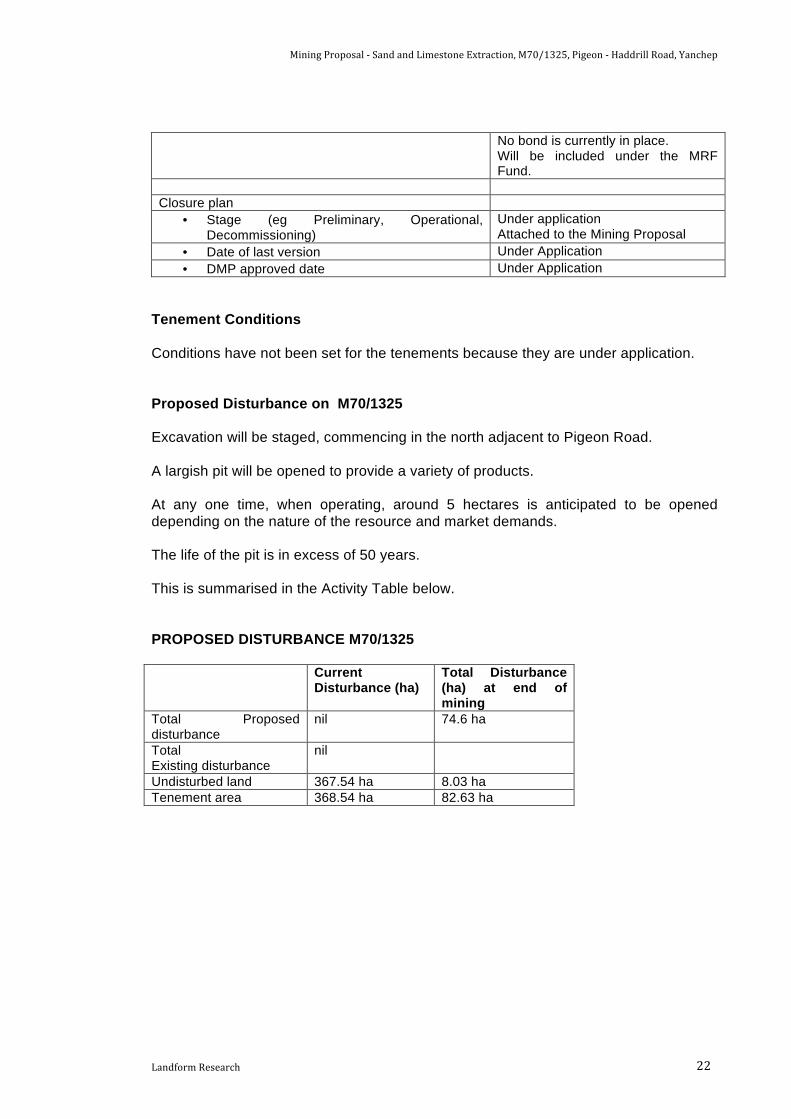
Tenement Conditions Conditions have not been set for the tenements because they are under application. Proposed Disturbance on M70/1325 Excavation will be staged, commencing in the north adjacent to Pigeon Road. A largish pit will be opened to provide a variety of products. At any one time, when operating, around 5 hectares is anticipated to be opened depending on the nature of the resource and market demands. The life of the pit is in excess of 50 years. This is summarised in the Activity Table below. PROPOSED DISTURBANCE M70/1325 Current
Disturbance (ha) Total Disturbance (ha) at end of mining
Total Proposed disturbance
nil 74.6 ha
Total Existing disturbance
nil
Undisturbed land 367.54 ha 8.03 ha Tenement area 368.54 ha 82.63 ha

Mining Proposal -‐ Sand and Limestone Extraction, M70/1325, Pigeon -‐ Haddrill Road, Yanchep
Landform Research 23
ACTIVITY TABLE M70/1325
Current Activity (ha)
Proposed Activity (ha)
Year 5 Year 10 Year 20 Final Open pit nil 5.0 ha 5.0 ha 5.0 ha nil Cleared ahead of excavation
nil nil nil nil included
Access tracks Minor forest tracks
0.5 ha 1.0 1.0 included
Processing nil In open pit In open pit In open pit included Stockpiles nil In pen pit In open pit In open pit included Waste dumps nil nil nil nil included Rehabilitated land nil nil 5.0 ha 15 ha 74.6 Land to be Rehabilitated nil 5.5 ha 6.0 ha 6.0 ha nil Total Disturbed Ground 0 5.5 ha 11 ha 21.0 ha 74.6 ha Undisturbed land 82.63 ha 77.13 ha 71.63 ha 66.63 ha 8.03 ha Tenement area 82.63 ha 82.63 ha 82.63 ha 82.63 ha 82.63 ha
3.2 Mining Operations An anticipated production of up to 100 000 tonnes per year of sand is proposed initially, depending on contracts won and rising to 300 000 tonnes per year. At any one time approximately 5 hectares of ground is proposed to be open with rehabilitation following excavation. It is anticipated that a larger tonnage will be taken in some years to fill large contracts such as major developments within the Northern Metropolitan Region. When larger contracts are being filled perhaps more than the nominated average amount of material may leave the site in a particular year. Design of the Pit - Staging The staging will minimise the disturbance of vegetation clearing by providing a staged clearing, excavation and rehabilitation program that will move across the site. The anticipated rate of excavation is shown in the Activity Table above. The excavations are designed to remove the sand and the limestone to a depth of 5 to 15 metres depending on the thickness of the resource. In some locations where specialty sand such as concrete or brikkies sand descends to greater depths excavation may go deeper provided the final land surface can complement the surrounding land. Government Policies currently provide for a separation of 2 metres outside Priority 1 Groundwater Protection Areas. As the site is 20 plus metres to the water table that limitation is not anticipated to apply because excavation will not approach the water table.

Mining Proposal -‐ Sand and Limestone Extraction, M70/1325, Pigeon -‐ Haddrill Road, Yanchep
Landform Research 24
The floor will be left undulating to match the surrounding landscape and assist revegetation. The batter slopes would then rise gently up the existing natural land surface outside the excavation area at slopes of 1 : 6, no greater than horizontal to vertical, that will be suitable for the continued plantation activities. Ground Preparation 1. A bulldozer or loader will be used to remove any vegetation by pushing it into
windrows. 2. Any large native logs will be either recovered for useable purposes or to form
barriers. All pine trash has to be burnt to remove the potential food supply to the European Wood Borer, a pest of pine wood.
3. Smaller vegetation will be track crushed and directly transferred to areas under
rehabilitation to assist soil and habitat generation. The vegetation contains a significant seed source, because of the contained seed on many species. It is also a source of microbial material for soil formation, adds to habitat and assists in managing wind erosion.
4. The vegetation will also be used on the batters to minimise soil erosion and
spreading on the final land surface as part of the final rehabilitation. 5. Topsoil will be pushed to one side and formed into low storage dumps for later use
for rehabilitation using either a loader or bulldozer. 6. Overburden will then be pushed to the perimeters, normally by bulldozer, to form
bunding around the active area. 7. The bunds will be up to 3 metres high depending on the surrounding landform and
security requirements, to increase security and provide a barrier to define the operations.
8. This bunding will be extended along all perimeters prior to the commencement of
excavation in a particular area. All stages of the pit excavation will be screened by bunds, which will be formed as required.
Excavation Sand Excavation 1. Excavation will be carried out as a sequence. 2. The excavation will be similar to excavation on other local quarries. 3. Perimeter screening bunds are to be formed to elevations of approximately 3
metres to provide visual, dust and noise screening and assist security. 4. Overburden, as sub-grade sand and overburden, will be removed by pushing to the
perimeter of the proposed pit to form perimeter bunding to the pit.
Mining Proposal -‐ Sand and Limestone Extraction, M70/1325, Pigeon -‐ Haddrill Road, Yanchep
Landform Research 25
5. This bunding will be extended along all perimeters prior to the commencement of
excavation in a particular area. All stages of the pit excavation will be screened by formed bunds, which will be formed as required.
6. Sand will be excavated using a loader, loading either directly to a road truck, in
which case there will be no need for stockpiles, or loading to a screening plant when stockpiles will be formed of the various products.
7. Water will be used for dust suppression, to reduce the potential for dust generation
from the movement of machinery and the effect of wind. 8. Depending on the depth of the resource, the nature and grade of the resources and
their thickness, benches may be required to differentiate product and assist safety. 9. Sand will be excavated to a minimum of 5 metres above the water table provided
the grade remains sufficiently high.
3.3 Processing Sand Only specialty sand will require screening such as plasterers’, concrete or filter sand. It is possible that a wash plant may be installed at some point in the future, but it is not proposed now and would only be used on site if there was water from a site bore available. 1. The main processing of sand will be screening of some sand to produce even
grainsize for special uses such as for use in concrete. 2. Fill sand is not processed and is not included in the tonnages of the DER Licence. 3. The sand may also be washed using a mobile wash plant that removes the fine clay
and iron oxide from the grains, producing a high grade silica sand. 4. The batter slopes will be retained in a stable form to comply with the Mines Safety
and Inspection Act 1994 with slopes battered to 1 : 4 to 1 : 6 vertical to horizontal. 3.4 Tailings Storage
There are no tailings apart from organic matter that may be encountered from washing of products. Washing is not anticipated but if it is used the only product will be natural organicmatter or clay recovered from washed sand which will be spread with the topsoil to assist with rehabilitation and improve the inherent created soil capability for plantation. See 3.2 Mining Operations above.

Mining Proposal -‐ Sand and Limestone Extraction, M70/1325, Pigeon -‐ Haddrill Road, Yanchep
Landform Research 26
3.5 Support Facilities The following equipment is anticipated to be used on site. It is anticipated that mobile plant will be shared between M70/1325 and M70/1326. A fenced compound will be required for the security of associated support facilities.
Site office/lunchroom • A portable site office/lunchroom is to be maintained on site for the management and security of small items during campaigns.
• This facility will be installed at the northern part of the project.
• As the pit progresses the facility may be moved northwards to keep place with the excavation to provide better supervision.
Toilet system • Initially an approved serviced portable toilet system will be used, but this will be replaced by an approved septic toilet system if a weighbridge is constructed on site.
• The toilet will be integrated with a site office. Storage shed • A storage shed to secure vehicles and/or other
equipment is likely to be located within the fenced compound near the administration.
Storage sheds • A storage container may located in a fenced compound to be located initially in the south western corner associated with the site office. See above.
Fenced compound • A fenced security compound is to be used to secure facilities and plant. See above.
Bulldozer • Bulldozer equivalent to D11 is to be used on site for land clearing or brought to the site as required.
Water tanker • A 10 000 L water truck or similar is to be used for dust suppression on the access road and working floor as required.
Excavator • An excavator is proposed to be used from time to time to mainly move some types of sand.
Loader • Loaders (Cat 980 or similar) are to be used for the movement of sand, loading road trucks and feeding crushing and screening plant.
• At times there may be two loaders on site. Weighbridge • A weighbridge may be located on the access road
from Pigeon Road at some point in the future, but is not proposed at this stage. As the excavation progresses the weighbridge is anticipated to be relocated to be closer to the operational area.
Mobile screening and wash plants. • Screening will represent a small part of the operations. Most material removed from site will be fill sand that does not require processing.
• Mobile screening plant (licensed by DER) will be utilised for the processing of limestone and some sand, if required.
• Screening plant are electric and combined with a Genset generator.
• A mobile wash plant may be required at some point in the future but is not proposed at this time.
• All mobile plant will be located on the floor of the

Mining Proposal -‐ Sand and Limestone Extraction, M70/1325, Pigeon -‐ Haddrill Road, Yanchep
Landform Research 27
excavation and move as the excavation moves across the site.
Fuel Storage • Vehicles will be refuelled from mobile tankers. • No fuel is proposed to be located on site at this
time, although it remains a possibility at some future time for a particular campaign.
• If fuel storage is maintained on site during campaigns it will be located in a dedicated secure area installed with a bunded impermeable liner associated with the site office.
• Any storage facility will be a double skinned self contained tank compliant with the Dangerous Goods Safety Act 2004 and relevant regulations.
All static and operational equipment will operate on the quarry floor or behind bunds of overburden where possible, to provide maximum sound and visual screening where possible. Water Supply M70/1325 lies within the Gnangara Groundwater Area. A bore will be applied for on site, but there may be no allocations available. If any allocation becomes available the Department of Water will ensure that only allocations that are sustainable will be issued with respect to the catchment of wetlands to the west. If on site water is not available then water will be brought to site as required. Water will only be required for dust suppression, because whilst washing of sand is considered a possibility it is unlikely. An annual water requirement of 5000 – 10 000 kL is anticipated to be required which is similar to one hectare of horticulture. Loading and Transport WA Limestone uses a variety of contractor vehicles to transport sand from their quarries. Bearing in mind this location, market locations and proximity to the Old Yanchep Road and Wanneroo Road, road trains may be used if permitted by Main Roads. Access will be along a formed road through the pit as shown on the attached Figures.
3.6 Workforce
The site will be worked by 2 – 3 persons, depending market demands. The operator will have radio contact with any vehicles and can check in regularly during the working day although vehicles will mostly be within view of each other. Truck drivers will regularly arrive at the site throughout the working day.

Mining Proposal -‐ Sand and Limestone Extraction, M70/1325, Pigeon -‐ Haddrill Road, Yanchep
Landform Research 28
Hours of operation will be worked in campaigns from 6.00 – 6.00 pm six days per week, Monday to Saturday excluding Public Holidays.
3.7 Transportation Corridors The access road from the site will enter from Pigeon Road or Haddrill Road. The travel route will be to Old Yanchep Road and Wanneroo Road.
3.8 Resource Requirements and Regional Infrastructure Regional resource requirements are as follows; • Water supply is not required for excavation. • Scheme water is not required. • A bore will be required for dust suppression along the transport route and
processing floor. If a Licence allocation is not available water will be brought to the site as required.
• Potable water is to be brought to site. • External power is not required. Any screen is self powered or connected to a
genset. • Fuel will be brought to site as required. (see 3.3 Support Facilities). A contingency
for fuel to be stored on site for a large campaign remains an option for limited times. • Municipal waste servicing is not required. • WA Limestone has had no significant pollution incidents at any of its quarries.
3.9 Compliance with Legislation, Conditions and Other Approvals Legislation The main legislation is the provisions of the Mining Act 1981. The project will operate under the Mines Safety and Inspection Act 1994. A Quarry Manager will be appointed and a Project Management Plan will be prepared for approval and implemented. Clearing Permits A Clearing Permit under the Environmental Protection (Clearing of Native Vegetation) Regulations 2004 will be required. This will be applied for to the Department of Mines and Petroleum through the delegated authority. Approval under the Commonwealth EPBC Act 1999 may be required. If the proposed clearing of native vegetation exceeds the current trigger level, referral under the EPBC Act will be undertaken. Conditions As this is a new application there are no conditions attached to the applied for tenement.

Mining Proposal -‐ Sand and Limestone Extraction, M70/1325, Pigeon -‐ Haddrill Road, Yanchep
Landform Research 29
Groundwater Elevation Excavation will be some 20 metres above the highest known water table well in exceedance of the Department of Water Guidelines for quarries of 2 - 3 metres. Department of Environment Regulation Licence A Licence for screening may be required under the Environmental Protection Act 1986 and Regulations 1987. If required a Licence will be applied for.
3.10 Buffers The issue of appropriate buffers is a matter of the distance and protection measures to prevent impact on adjoining land users. This applies mainly to noise, dust and visual impact, all of which are treated separately. A number of Government Policies relate to buffer distances and the protection of basic raw materials. State Planning Policy No 4.1, State Industrial Buffer Policy, (1997) discusses the need to consider adjoining land uses when locating buffers but does not prescribe set buffers for operations such as this. A draft updated policy (draft July 2004) reinforces these principles. State Planning Policy No 2.5, Agricultural and Rural Land Use Planning, makes provision for the extraction of basic raw materials. SPP 2.5 in Point 9 states that "The location of rural residential and rural small holdings should avoid unacceptable impacts on, or sterilisation of natural primary resources including prospective areas for mineralisation and basic raw materials ......". Generic buffer requirements were developed by the Victorian Government and used by the Environmental Protection Authority as the basis for a Draft guideline on recommended buffer distances. These formed the basis of EPA Guidance Statement Number 3, Separation Distance between Industrial and Sensitive Land Uses, June 2005. EPA guidance "Separation Distances between Industrial and Sensitive Land Uses", June 2005 lists the generic buffers for limestone pits as 300 - 500 metres depending on the extent of processing. For quarries with crushing, milling or screening the buffer distance is listed as “case by case”. A generic buffer relates to the distance at which there are unlikely to be any problems without some further investigations and does not mean that smaller buffers are not acceptable. These buffers relate to noise and dust. The EPA South Australia in Guidelines for Separation Distances 2007 suggests a generic buffer of 300 metres and makes provision for lesser setbacks where the proponent is to “demonstrate why the lesser separation distance would be appropriate”. The EPA South Australia also state that the guidelines are “generally more conservative than the separation distances predicted by air pollution or noise modelling”. The South Australian generic buffer also provides for a mechanism whereby the distance is modified by landform, vegetation cover and prevailing winds.

Mining Proposal -‐ Sand and Limestone Extraction, M70/1325, Pigeon -‐ Haddrill Road, Yanchep
Landform Research 30
The EPA Victoria recommended separation distances for industrial residual emissions 2013, are the “default minimum in the absence of detailed site specific assessment for a proposed industrial or sensitive land use”. The EPA Victoria default minimum separation for a quarry of this type is 250 metres. There are two parts to buffers. Firstly a buffer that must be in place when a quarry is proposed to be located near sensitive premises and secondly where sensitive premises are proposed to be located near existing quarries. The other relevant aspect to buffers is the influence of the bunds and vegetation within the buffers. Information on this is contained in Department of Natural resources Queensland 1997, Planning Guidelines Separating Agricultural and Residential Land Uses. This document discusses the effectiveness of a 40 metres wide tree buffer. The same is outlined in the Department of Health WA, 2012, Guidelines for Separation of Agricultural and Residential Land Uses, establishment of buffer areas. The excavation will be worked from the floor of the pit with the landform, distances and nearby pines and trees assisting visual management. The proposed excavation is isolated with over 2 km to sensitive premises to the south west at Old Yanchep Road. The excavation complies with all the buffer guidelines.
4.0 ENVIRONMENTAL IMPACTS AND MANAGEMENT
4.1 Land Clearing Clearing is covered by the Environmental Protection (Clearing of Native Vegetation) Regulations 2004. The site is covered by native vegetation in Degraded Condition as assessed by Mattiske 2014 with the old pine plantation present. The site is to be progressively cleared, excavated and then rehabilitated to local native species. The tenement that has been active plantation for many years under Prescribed Clearing Section 5 (14) (a) of the Environmental Protection (Clearing of Native Vegetation) Regulations 2004, will not require a Clearing Permit. If plantation is a continued landuse then a permit will not be required. On the other hand if plantation is not a continuing land use then a Clearing Permit will be required. Even though the vegetation is “Degraded”, a potential offsets proposal has been investigated by CO2 Australia Australia and is attached as Appendix 6. The offsets are proposed in conjunction with excavation on M70/1326 to the south west. A summary of the concept offsets is explained in 4.3.3 Ecosystems and, in concept, provides for high levels of protection of Carnaby’s Black Cockatoo foraging habitat of in excess of 180 hectares and the formation of new foraging habitat and linkages of 320 hectares, in addition to saving the State Government an estimated $2 million in compensation payments.

Mining Proposal -‐ Sand and Limestone Extraction, M70/1325, Pigeon -‐ Haddrill Road, Yanchep
Landform Research 31
In addition the return of M70/1325 to local native vegetation will result in creation of feeding habitat for Carnaby’s Black Cockatoo. The amount of ground open at any one time is anticipated to be 5 hectares, and with a five year growth period to provide foraging habitat, the development of a significant feeding habitat will be progressively formed to compensate for the original clearing and the clearing of the pines.
4.2 Water There are no watercourses, wetlands or water bodies on site. M70/1325 lies within the Gnangara Groundwater Area. Water for dust suppression is to be sourced from a Licensed bore to be applied for to Department of Water. If a water allocation is not available water will be brought to site as required. If any allocation becomes available the Department of Water will ensure that only allocations that are sustainable will be issued. A separate Water Management Plan is attached. This addresses the issues relating to the protection of groundwater and assesses the potential risks to the conservation values related to the local area. As discussed in the Water Management Plan the proposed excavation has been designed to comply with the requirements of Department of Water and minimise or negate any risk to the groundwater system. The Water Management Plan also discusses water balance with the proposed excavation.
4.3 Flora, Fauna and Ecosystem Management 4.3.1 Flora Mattiske Consulting Pty Ltd was commissioned in November 2013 by WA Limestone to undertake a Level 2 flora and vegetation survey of the Yanchep Ridges survey area. The flora and vegetation report is attached as Appendix 2. A summary of the findings of the Mattiske Report are included at 2.7.1 Flora with the whole document located at Appendix 2 which covers both M70/1326 and M70/1325. Even though Mattiske found a total of 207 vascular plant taxa, which are representative of 122 plant genera and 46 plant families, within the Yanchep Ridges survey area, the majority will not occur on M70/1325 which Mattiske lists as “Degraded”. A copy of the Flora Report is attached as Appendix 2. It should be noted that the flora study relates to both M70/1325 and M70/1325.

Mining Proposal -‐ Sand and Limestone Extraction, M70/1325, Pigeon -‐ Haddrill Road, Yanchep
Landform Research 32
Plant Communities M70/1325 is part of State Forest 65 referred to as “The Ridges” an area with long-standing recommendations to be added to Yanchep National Park (Department of Conservation and Environment 2012). The site lies in the Swan Coastal Plain Unit of the Drummond Botanical Subdistrict, part of the greater South-West Botanical District (Beard 1990). More recently, the vegetation of Western Australia has been assigned to bioregions and subregions under the Interim Biogeographic Regionalisation for Australia (IBRA), with the project area being within the Swan Coastal Plain subregion. The original vegetation prior to clearing for pine plantation would have been classified as within the Drummond Botanical Subdistrict as characterised by low Banksia woodlands on leached sands, Melaleuca swamps on poorly-drained depressions, and Eucalyptus gomphocephala (tuart), Eucalyptus marginata (jarrah) and Corymbia calophylla (marri) woodlands on less leached soils (Beard 1990). The Drummond Botanical Subdistrict comprises twelve physiographic units (systems), with the survey area situated within the Spearwood System. The Spearwood System comprises yellow sands which gradually become more bleached and less calcareous to the east of the system. This is characterised by two dominant overstorey associations namely Eucalyptus gomphocephala woodlands and E. gomphocephala -Eucalyptus marginata mixed woodlands. Outside these two, major overstorey transition zones occur in the form of Banksia-Calothamnus heaths, Agonis flexuosa low woodlands and Melaleuca preissiana, Melaleuca rhaphiophylla and/or Banksia littoralis in low lying and/or swampy areas. Five vegetation communities were delineated and mapped within the survey area across both M70/1325 and M70/1326. The whole of M70/1325 is classified as Community E, See Figure 2 Regenerating vegetation on felled pine plantation. The communities listed above may have occurred prior to clearing for pines but do not now occur on site. Bush Forever 381 M70/1325 lies outside Bush Forever site number 381 but touches it in the south and west. An offset proposal is being investigated by CO2 Australia and is attached as Appendix 6. A summary of the Offset proposal is included at 4.3.3 Offsets. 4.3.2 Fauna WA Limestone commissioned Western Wildlife to undertake a Level 1 fauna survey of the proposed quarry area during December 2013. A copy of the survey report is attached as Appendix 3. All the information on fauna is taken from Western Wildlife 2014.

Mining Proposal -‐ Sand and Limestone Extraction, M70/1325, Pigeon -‐ Haddrill Road, Yanchep
Landform Research 33
The southern site M70/1326) is likely to support a relatively intact assemblage of native fauna in the Banksia woodland, limestone heath and Tuart habitats, but the faunal diversity and species richness on M70/1325 is likely to be reduced due to past disturbance and the plantation, The potential impacts of quarrying have been identified by Western Wildlife. It is proposed to minimise the impacts by progressively clearing the site, excavation of the cleared area, followed by progressive rehabilitation. The minimisation of the loss of vegetation and habitat has been incorporated into the design of the operation and the Mining Proposal and Mine Closure Plan. The development of the sand quarry will result in little loss of fauna habitats, and will eventually lead to the formation of greatly improved habitat with a return to Banksia Woodland. Even so the potential impacts from quarrying identified by Western Wildlife are listed below.
• Direct mortality of fauna • Habitat loss • Habitat fragmentation • Habitat degradation • Road mortalities • Increased disturbance to fauna • Increase in feral predators
The following recommendations on minimising potential impacts are listed from Western Wildlife. The proposed management is included under each section.
• Where possible, restrict construction of access roads, firebreaks and fence-lines to existing cleared tracks.
• Avoid clearing during late winter and spring in order to minimise the mortality of young birds in nests.
• Minimise the quarry footprint so far as practicable, in order to maximise the amount of native vegetation retained.
• During clearing or construction, avoid disturbance to adjacent areas of native vegetation that are to be preserved.
• Where possible, preserve Tuart trees with a DBH >/= 50cm, particularly those with existing hollows. (There are no trees remaining on M70/1325).
• Carry out appropriate revegetation of the site after the completion of quarry activities.
• Maintain habitat corridors to allow for east – west movement of fauna. • Avoid the creation of isolated patches of habitat within the quarry development
area. • Manage dust emissions from the site to minimise dust penetrating adjacent
bushland. • Develop controls to minimise weed invasion into adjacent bushland. • Develop controls to minimise the risk of accidental fires. • Consider temporary fencing along roads during clearing, to prevent fauna
exiting the site. • Conduct clearing in a progressive manner, to encourage fauna to move away
from roads and towards adjacent remaining bushland.
Mining Proposal -‐ Sand and Limestone Extraction, M70/1325, Pigeon -‐ Haddrill Road, Yanchep
Landform Research 34
• Where practicable, situate noisy activities away from the larger areas of remaining bushland in order to reduce the amount of disturbance to fauna.
• Minimise light spill into adjacent bushland by using the minimum of outdoor lighting.
• Ensure that food and other wastes are secure from feral animals. Direct mortality of fauna Direct mortality of fauna may occur when clearing or construction activities are carried out. For example, small terrestrial fauna species, young birds in nests and fauna roosting in hollows are usually unable to move out of the way of large machinery. Some direct mortality of fauna is usually unavoidable, and although it is unlikely to affect the conservation status of any species in this case, it is desirable to minimise it where possible. Habitat loss Almost all native fauna rely on native vegetation for foraging, shelter and nest sites. Any clearing in the study area is likely to result in some habitat loss for native fauna. The habitat on site is significantly reduced and will be improved by excavation and revegetation to Banksia Woodland. The area open at any one time is to be minimised. Habitat fragmentation In an un-fragmented landscape fauna are free to move, allowing gene-flow between populations and the capacity to move to take advantage of dispersed or temporary resources such as food or nesting sites. Much of M70/1325 is already cleared and disturbed so restrictions on the movement of fauna are likely to lessen. The general principles are listed below. Western Wildlife noted that during clearing natural animal movements can be disrupted, and if a complete barrier is formed between populations, genetic isolation results. It can be difficult for fauna to move through a landscape that includes areas of cleared land, and this difficultly will be greater for some species than others. Highly mobile species (such as some birds) may be able to negotiate cleared areas to travel between isolated patches of native vegetation. Small ground-dwelling species (such as many reptiles) may not be able to traverse cleared land, impacting on their ability to maintain gene-flow between populations. Excavation is proposed to be progressive followed by rehabilitation to ensure that the fragmentation of vegetation is minimised and that fauna are able to move with minimal impediment. The site will be rehabilitated to Banksia Woodland.

Mining Proposal -‐ Sand and Limestone Extraction, M70/1325, Pigeon -‐ Haddrill Road, Yanchep
Landform Research 35
Habitat degradation Dust, weeds and altered fire regimes can affect habitats adjacent to a development, causing habitat degradation. This may occur on remaining bushland within a development area, or in adjacent bushland areas. The habitat will be improved as a result of extraction and revegetation. Dust may be generated from the quarrying process and from the action of vehicles on roads. Dust can penetrate into adjacent bushland areas, covering vegetation and changing soil surface conditions. Weeds may be brought in to a site on vehicles, and/or spread into adjacent bushland along the increased ‘edge’ created by clearing. Increased fires can also exacerbate the spread of weeds. The response of fauna to fire is complex. Many native mammal species on the northern Swan Coastal Plain are at risk from too frequent or too large fires and overall reptile abundance is higher in long-unburnt areas. Overall, maintenance of a diverse range of post-fire aged habitat, including long-unburnt habitat, is thought to best provide for the diversity of fauna in the region and this is proposed. In any development there is a risk that more fires may occur accidentally and burn out large areas of habitat. A comprehensive dust management plan is proposed. In other locations such as Wesco Road Mining Tenements and WA Limestone at Flynn Drive, the excavation of limestone adjacent to native vegetation does not appear to significantly impact on the habitat quality. A weed monitoring and management program is proposed. Fire management remains a normal part of quarrying operations. Fires are normally caused by external impacts such as lightning or illegal burning rather than quarrying which takes place on bare sand which acts as a highly effective firebreak. Road mortalities Road mortalities are undesirable as they may have impacts on local wildlife populations, may have ethical issues (e.g. injured or orphaned wildlife) and can affect human safety on the road. Experience at other quarries operated by WA Limestone such as at Flynn Drive or Hopkins Road Carabooda shows that this is not a significant issue. The road trucks are travelling slowly and drivers are aware of the potential for fauna to occur. Increased human disturbance to fauna Disturbance to fauna can be due to noise, vibration, movement or light, and includes examples such as the use of vehicles, earthmoving equipment, workshop noises, office or driveway lighting, or the presence of people.

Mining Proposal -‐ Sand and Limestone Extraction, M70/1325, Pigeon -‐ Haddrill Road, Yanchep
Landform Research 36
Disturbance to fauna may result in fauna avoiding an area, e.g. due to excessive noise, and therefore being unable to utilise an area of available habitat. Fauna may also experience increased stress and/or expend extra energy in avoidance behaviours. Interestingly at most quarries whilst some fauna may be impacted it is common for larger fauna to be unaffected by the activity or even be attracted by it. The provision of water encourages fauna, particularly larger fauna such as mammals and some birds. The disturbance footprint and progressive rehabilitation will be used. Increased feral predators Feral predators in the study area are represented by the fox and cat. Feral predators may compete with native predators, and also prey on a range of native fauna including frogs, reptiles, birds and small mammals. Mammals and birds of about 200g or under are most at risk from cat predation, as are ground foraging or ground nesting birds. There is unlikely to be any change to predators because the site is cleared plantation. Increased habitat fragmentation of native vegetation may make native fauna more vulnerable to predators where they have to negotiate cleared areas, and the presence of waste (e.g. skips and bins) can attract feral predators to a site. Apart from the vegetation disturbance there will be no encouragement given to feral species in the form of food, waste or other attractions.
4.3.3 Ecosystems The excavation footprint and Mining Proposal has been designed to minimise the loss of significant habit and communities. There will be an increase in habitat with a conversion to Banksia Woodland. The impact, on Ecosystems are considered under 4.3.1 above. Offsets Even though M70/1325 is located on cleared pine plantation a comprehensive preliminary offset program has been developed CO2 Australia in conjunction with M70/1326. This is attached as Appendix 6. See also 4.1 Land Clearing. The concept offset package could include portion of Lot 1 Nowergup Road Nowergup owned by WA Limestone, Lot 100 McCormick Street Seabird owned by WA Limestone and the creation of a restored vegetation linkage joining Yanchep National Park with Yeal Nature Reserve. The full extent of the offsets would not be applied if M70/1326 was not also approved for mining.

Mining Proposal -‐ Sand and Limestone Extraction, M70/1325, Pigeon -‐ Haddrill Road, Yanchep
Landform Research 37
The northern portion of Lot 1 could be protected by Covenant or ceded to the State to add to the Neerabup National Park. The offset would potentially save the State up to $2 million in not having to provide compensation for the portion of Lot 1 north of Nowergup Road. Lot 100 McCormick Road, Seabird has an area of 303.75 hectares and has the potential to form an offset equivalent to 170 hectares of Carnaby’s foraging habitat. The potential wildlife corridor to link Yanchep National Park to Yeal Nature Reserve would convert pine plantation to Proteaceous feeding habitat suitable for Carnaby’s Black Cockatoo. A preliminary estimate of the cost of providing this offset is $3 250 - $4 500 per hectare over an area of approximately 320 hectares. This is in addition to the return of M70/1325 to local native vegetation which will result in a temporary reduction in habitat and Carnaby’s Black Cockatoo feeding habitat but not be a total loss. The amount of ground open at any one time is anticipated to be around 5 hectares and with a five year growth period to provide foraging habitat, a total reduction in habitat at any one time of around 6 hectares is anticipated. Depending on the position of the Forest Products Commission the site may be prepared for pines and then planted by the FPC. 4.3.4 Wetlands There are no wetlands on site and none that occur nearby or locally. A Water Management Plan is attached. Investigations have found that the proposed excavation and progressive clearing and rehabilitation to native vegetation will not result in any significant changes to the local hydrogeological regime.
4.4 Topsoil and Soil profiles The topsoil consists of grey to grey brown sand that is up to 100 - 200 mm thick depending on the depth of the sand and nature of the sand. It contains organic and other vegetation fragments. The topsoil will be cleared prior to excavation and saved in low perimeter bunds when it cannot be directly returned to completed ground as part of the revegetation process. In some parts there is subgrade sand as overburden. Depending on its thickness, it will be stored separately in perimeter bunds for surface restoration when thick. From the sampling and observation the overburden is thin and the sand below 200 – 300 mm is normally useable resource. The soils, sand and limestone are all natural materials with no capacity to create adverse soil conditions. There is no peat or acid conditions. The underlying limestone ensures that the groundwater remains neutral.

Mining Proposal -‐ Sand and Limestone Extraction, M70/1325, Pigeon -‐ Haddrill Road, Yanchep
Landform Research 38
The clearing, retention and use of topsoil is described within 3.2 Mining Operations and the attached Mine Closure Plan. See the attached Water Management Plan.
4.5 Domestic and Industrial Waste Products All domestic and commercial waste will be collected and taken to an approved landfill. Any hydrocarbons in terms of oils and greases will be taken to an approved landfill or disposal site. An approved serviced portable toilet system will be used with a septic toilet system installed if a weighbridge is established.
4.6 Waste Rock and Tailings Management
This is covered by 2.4 Waste Rock and Tailings and 3.4 Tailings Storage There is in effect no waste rock, soils or other adverse materials. Any organic matter will be spread across the rehabilitation surface. Organic matter recovered from any washing of the sand, if that is used at some point in the future, will be spread over areas to be rehabilitation.
4.7 Hydrocarbon Management In order to control marine pollution, any spillage or leaks of fuels from machinery involved in the process will be managed appropriately. Hydrocarbon Management is discussed in the attached Water Management Plan. Below is a summary. 4.7.1 Fuel Storage Fuel is not normally proposed to be stored on site, with mobile and fixed plant being refueled from a mobile tanker. There does remain the possibility for fuel to be stored on site for a particular campaign of excavation. If retained on site fuel will be stored in a small double skinned self contained tank retained for fuelling vehicles and mobile plant. 4.7.2 Fuel Spill Management Plan The following activities and management proposed is summarised below. More detail is provide in the attached Water Management Plan. • Fuel will be used and stored in accordance with the DER/DOW – DMP Water
Quality Protection Guidelines for Mining and Mineral Processing, Mechanical servicing and workshop facilities and Above-ground fuel and chemical storage.

Mining Proposal -‐ Sand and Limestone Extraction, M70/1325, Pigeon -‐ Haddrill Road, Yanchep
Landform Research 39
• Sand and limestone are highly adsorptive. The main risk of contamination is the
minor drips that occur during the removal of hoses etc. Minor spills are quickly degraded by soil microbial matter.
• Refuelling and lubricating activities are to only occur in designated areas, and
equipment for the containment and clean-up of spills is to be located at the site office and on service vehicles.
• Spillage will be contained in plant and working areas by shutting down plant or
equipment if the plant or equipment is the source of the spill (provided it is safe to do so).
• Waste substances and chemicals will be dealt with in accordance with the Site
Waste Guidelines. • All significant adverse incidents (such as a fuel spill of >5 litres) in one dump, are
recorded, investigated and remediated. A record is to be kept of incidents and the Department of Mines and Petroleum, Forest Products Commission, City of Wanneroo and Department of Water notified within 24 hours. No such incidences have been recorded on any WA Limestone operations within the past 20 years.
• Any spills will be contained by the excavation or processing area. A fluid spill
emergency response kit will be retained. For larger spills soil and resource will quickly be placed around the spill to contain it in as small an area as possible. When contained, the contaminated sand and limestone soils will be scooped up and removed to an approved landfill or other approved site.
• The only other risk is from a tank rupture, but tanks are designed to manage this
eventuality. Soil contaminated by large spills will be removed from the site to an approved disposal area.
• Fuel spill emergencies are included, in site training and inductions. 4.7.3 Servicing and Maintenance The following activities and management are used at all WA Limestone pits and are proposed for this site. Below is a summary with more details provided in the attached Water management Plan. • All major servicing of vehicles is to be conducted off site at WA Limestone Bibra
Lake facility. • Only minor servicing and lubrication is conducted on site such as in the pit, using
self contained mobile facilities based at WA Limestone Bibra Lake and contractor vehicles. These vehicles will remove all waste materials.
• Vehicle washdown is not proposed. • Regular inspections and maintenance of fuel, oil and hydraulic fluids in storages
and lines are carried out for wear or faults.

Mining Proposal -‐ Sand and Limestone Extraction, M70/1325, Pigeon -‐ Haddrill Road, Yanchep
Landform Research 40
• Servicing plant and equipment will be maintained in accordance with a maintenance
schedule. • Accidental spill containment and cleanup protocol is to be provided. • The site is to be maintained in a tidy manner
4.8 Dangerous Goods and Hazardous Substances
Apart from fuel, none are used on site or are proposed to be used. All storage facilities for lubricants and oils comply with requirements of AS1940 and the Dangerous Goods Safety Act 2004 and relevant Regulations.
4.9 Atmospheric Pollution and Noise
The only atmospheric pollution may be airborne dust and noise. 4.9.1 Dust See the separate Dust Management Plan. Environmental Dust Dust has the potential to be generated during most phases of the quarrying and crushing operation, particularly during summer. It is mostly associated with traffic whether it be road traffic or mobile plant on the floor, rather than excavation. Limestone roads left through a winter or significant rainfall rapidly develop a crust through reprecipitation of the calcium carbonate and do not form a dust risk unless disturbed. In winter the frequent rains greatly reduce the potential dust emissions. The main risk is from the crushing and tipping processes and from vehicle movements. Dust may impact on onsite workers. Dust also has the potential to be visually intrusive and travel to adjoining properties if not managed. Dust management has been an integral part of the extraction and processing of limestone. Facilities and procedures are updated as better technology becomes available. Dust emissions fall under the Guidance for the Assessment of Environmental Factors, EPA, March 2000. Assessments of the potential dust risk are normally made using the Land development sites and impacts on air quality, Department of Environmental Protection and Conservation Guidelines, November 1996. These are still in place but are incorporated into the DEC 2011 Guideline for Managing the Impacts of Dust and Associated Contaminants from Land Development Sites, Contaminated Sites Remediation and other Related Activities. The key Environmental Objectives for the operations are;

Mining Proposal -‐ Sand and Limestone Extraction, M70/1325, Pigeon -‐ Haddrill Road, Yanchep
Landform Research 41
• Manage the potential for the generation of dust.
• Monitor dust levels and take steps to reduce the potential impact of dust on occupational and environmental aspects of the operation and local area.
When classified according to DEC (DER) 2011, and the operational dust management procedures are used, the operation of the pit will have a low risk of dust crossing the boundary. There are no close dwellings, with buffers in excess of 2 km. A separate Dust Management Plan has been prepared and is attached. The dust assessment and operational experience on other tenements shows that dust can be effectively managed on an operation such as this. Greenhouse Gas The development of the Northern Perth Regions has, and will over the next 100 years, generate the need for limestone and sand products, and if these cannot be obtained from this quarry they will be obtained from another. Over the years trucks have become more efficient with respect to greenhouse gas emissions, particularly with the use of truck and trailer and road train configurations. WA Limestone continues to seek ways to reduce the amount of fossil fuels used, and has obtained more efficient mobile plant and equipment when this has become economically available. The internal design of the operations attempts to minimise the haulage route to save energy use and potential impacts. Dust Monitoring The effectiveness of dust suppression is monitored visually, at all times during site activities. See Separate Dust Management Plan. Most dust generated from processing and vehicle movements has a very large visible component. Lesser risks emanate from excavation and land clearing. The trigger for dust management is the generation of visual dust. The quarry manager and leading hands are ultimately responsible for site supervision of dust. They travel around the operations and pit frequently and are in two way radio contact with all mobile plant. All operators on site will be instructed to be vigilant to dust generation and management and report any excessive dust or potential dust management issues. When trigger conditions are detected and/or alerted, relevant action will be taken. This can include additional water suppression, modification of procedure, delay until more favourable conditions are present, use of alternative equipment etc.

Mining Proposal -‐ Sand and Limestone Extraction, M70/1325, Pigeon -‐ Haddrill Road, Yanchep
Landform Research 42
WA Limestone provides induction and protective equipment for all persons on site. 4.9.2 Noise General Noise Regulation Offsite noise is governed by the Environmental Protection (Noise) Regulations 1997. The Environmental Protection (Noise) Regulations 1997, require that sensitive premises including dwellings in non industrial and rural areas, are not subjected to general noise levels (excluding blasting), during the hours 7.00 am to 7.00 pm Monday to Saturday that exceed 45 dBA. Allowable noise to 55 dBA is permitted for up to 10% of the time and to 65 dBA for 1% of the time. Noise levels are not to exceed 65 dBA during normal working hours. These are the current assigned noise levels that would apply. Between 9.00 am and 7.00 pm on Sunday and Public Holidays, and between 7.00 pm and 10.00 pm on all days, the base level is 40 dBA. At night, between 10.00 pm and 7.00 am Mondays to Saturday, and before 9.00 am on Sundays and Public Holidays the permitted level drops to 35 dBA. The 10% and 1% “time above” allowances apply at night and on Sundays and Public Holidays as well. There are penalties for tonality of 5 dB, modulation 5 dB and 10 dB for impulsiveness, that are added to the permitted levels. That is, if the noise is tonal or modulated the permitted levels drop by 5 dB. Impulsiveness is not likely to be relevant for the quarry under normal circumstances. Influencing factors that raise the allowable noise levels are activities such as external industrial noise, some nearby land uses and busy roads. Under Schedule 1 of the Noise Regulations the premises on which the extraction of basic raw materials such as sand and limestone is occurring is classified as Industrial Land for the purposes of calculating influencing factors. This was defined as the whole cadastral boundaries in State Administrative Tribunal decision {2013} WASAT 139, Bushbeach v City of Mandurah. In the case of Mining Tenements the premises for the purposes of the Noise Regulations would apply to the whole tenement area. With the 2 km setback to the closest dwelling exceeding the 300 metre circle for influencing factors the closest dwellings will not be subject to influencing factors as a result of the premises. At a distance greater than 15 metres from the sensitive premises (eg dwelling), and for commercial premises, a base level of 60 dBA applies at all times with the 10% time permitted to be up to 75 dBA and the 1% permitted to be up to 80 dBA. For industrial premises the base level is 65 dBA at all times with the 10% time permitted to be up to 80 dBA and the 1% permitted to be up to 90 dBA.

Mining Proposal -‐ Sand and Limestone Extraction, M70/1325, Pigeon -‐ Haddrill Road, Yanchep
Landform Research 43
If the closest land uses were classified as either industrial of commercial at some point in the future the assigned noise levels that would apply to those dwellings would change. Noise can originate from a number of operations and may impact on onsite workers, or travel offsite and impact on external sensitive premises. Both potential noise impacts are addressed by reducing the noise generated from the quarrying and processing operations. On this site there are no dwellings within 2 kilometres. WA Limestone will comply with the Environmental Protection (Noise) Regulations 1997. There are a number of management actions that can be taken in quarries to minimise noise generation or travel. These have been used in the past and will continue to be used. These actions are routinely used by WA Limestone where applicable and as the opportunity presents to minimise noise on the site. In addition to using the noise management techniques listed above wherever practicable, WA Limestone has site specific management procedures that are outlined below. Occupational Noise Occupational noise associated with the quarrying processes falls under the Mines Safety and Inspection Act 1994 and Regulations 1995. The management of occupational noise is normally handled by providing all necessary hearing protection, as well as conducting worker inductions and educational programs for all staff. Regular site audits of quarry and mining operations are normally conducted by the Department of Mines and Petroleum. As part of its commitments, WA Limestone continues to be pro-active with its worker safety awareness; • by providing all necessary safety equipment such as ear protection, • identifying sections of the plant where hearing protection is required, as well as, • conducting induction and educational programs for its staff. The operating noise levels around the site are regularly monitored by independent consultants in accordance with the Mines Safety and Inspection Act 1994, and the results communicated to the Department of Mines and Petroleum (DMP). All staff are provided with comprehensive ongoing training on noise protection as part of WA Limestone’s commitment to occupational health and safety. The DMP conducts inspections of all tenements and working operations. Warning signs will be used to identify areas of potential noise.

Mining Proposal -‐ Sand and Limestone Extraction, M70/1325, Pigeon -‐ Haddrill Road, Yanchep
Landform Research 44
Screening of Sand The noise suppression measures on screening plants are closely monitored, and appropriate signage is posted. A DER licence under the Environmental Protection Regulations 1987 would be required for crushing and screening plants. Like all parts of the operations the processing has to operate under the Environmental Protection (Noise) Regulations 1997. Truck Movements Trucks will enter from the south from Pigeon Road and Wanneroo Road. Transport on Public Roads is exempt from the Noise Regulations. OPERATIONAL PROCEDURES COMMITMENTS ON ACTIVITIES
CONDUCTED ON SITE • Comply with the Environmental Protection
(Noise) Regulations 1997.
• WA Limestone will maintain compliance with the Regulations
• Comply with the provisions of the Mines Safety and Inspection Act 1994 and Regulations 1995.
• WA Limestone is registered on the DMP SRS system and this pit will be so listed. The operations will be inspected regularly by the DMP.
• Maintain adequate buffers to sensitive premises.
There are no close dwellings within 2 km.
• Locate exposed features behind natural barriers and landform.
• Vegetated screening belts are already in place around the pit as the existing pines and adjoining native vegetation.
• Perimeter bunds will be constructed from the topsoil and overburden and will be extended as the pit progresses.
• Bunding will be completed prior to excavation of the nearest part of the pit.
• Operate from the floor of the pit below natural ground level.
• This is to be used on site and is proposed which will provide significant screening.
• Construction of bunds Bunds are to be constructed around the perimeter of the pit footprint prior to the excavation in each part of the pit. The bunds and pit faces will provide good acoustic screening.
• Push overburden and interburden dumps into positions where they can form screening barriers.
• Perimeter bunds will be constructed from the topsoil and overburden and will be extended as the pit progresses.
• Bunding will be completed prior to excavation of the nearest part of the pit.
• Design site operations to maximise the separation and protection from sensitive premises.
• See the discussions on Buffers above. • The shape of the pit and method of
operation will be designed to ensure the landform provides the best screening.
• Maintain all plant in good condition with efficient mufflers and noise shielding.
• WA Limestone has modern equipment that is maintained in good condition and

Mining Proposal -‐ Sand and Limestone Extraction, M70/1325, Pigeon -‐ Haddrill Road, Yanchep
Landform Research 45
replaced from time to time. • Maintain haul road and hardstand
surfaces in good condition (free of potholes, rills and product spillages) and with suitable grades.
• The access road and crossover will be maintained in good condition.
• Implement a site code outlining requirements for operators and drivers.
• WA Limestone maintains site induction and training for all personnel.
• Shut down equipment when not in use. • This is normal policy. • Scheduling activities to minimise the
likelihood of noise nuisance. • This is normal policy and will be
continued. • Fit warning lights, rather than audible
sirens or beepers, on mobile equipment wherever possible.
• Lights or low frequency beepers are to be used rather than high pitched beepers.
• The design and shape of the pit maximise noise screening.
• Use transport routes that minimise community disruption.
• The transport route is direct to Pigeon Road and then to Wanneroo Road.
• Avoid the use of engine braking on product delivery trucks in built up areas.
• The surrounding area is gently sloping with reduced gradients.
• Airbrakes are unlikely to be required. Drivers are to be instructed not to use air brakes under normal situations when exiting along the access road.
• Minimise and conduct at the least disruptive times, non day to day activities such as vegetation, topsoil or overburden stripping on exposed ridgelines.
• The operational hours are the same as most operating quarries away from residential areas, 6.00 am to 6.00 pm Monday to Saturday, excluding public holidays.
• Provide a complaints recording, investigation, action and reporting procedure.
• A complaints recording procedure is proposed to cover all site activities.
• Conduct training programs on noise minimisation practices.
• WA Limestone conducts site induction and training to all personnel.
• Provide all workers with efficient noise protection equipment.
• All noise protection personal equipment is provided to staff.
4.10 Vegetation Impacts 4.10.1 Vegetation Hygiene Management The site is covered by native vegetation. Therefore there is the potential for plant pathogens to be spread with the movement of soil and plant materials, so good plant hygiene is desirable. In the wetter parts of Western Australia, such as the south west, vegetation hygiene mainly relates to Phytophthora cinamomi even though there are other Phytophthora species and other diseases such as Armillaria that can cause dieback like symptoms. The same conclusions are made in the DER/DPaW Management Plans. In most cases vegetation death is caused by a pathogen which infects the plant and causes it to lose vigour, with leaves dying, and, overtime, may kill the plant. As such the management of plant disease is essentially related to plant hygiene when coming onto a site and within a site.

Mining Proposal -‐ Sand and Limestone Extraction, M70/1325, Pigeon -‐ Haddrill Road, Yanchep
Landform Research 46
The hygiene principles are proposed as part of good site management of potential plant pathogens. CALM generally recognises that Dieback is less likely to impact on vegetation on limestone and Spearwood/Cottesloe Land Systems, Podger F D and K R Vear, 1998, Management of Phytophthora and disease caused by it, IN Phytophthora cinnamomi and the disease caused by it - protocol for identifying protectable areas and their priority for management, EPA 2000. There are several guides to the management of plant hygiene (Dieback). • Department of Environment and Conservation CALM (DPaW) Dieback Hygiene
Manual 1992 is a practical guide to Dieback management. • Department of Environment and Conservation CALM (DPaW) Best Practice
Guidelines for the Management of Phytophthora cinamomi, draft 2004. • Dieback Working Group 2005, Management of Phytophthora Dieback in Extractive
Industries. • Dieback Working Group 2009, Managing Phytophthora Dieback in Bushland. As the location of the project is within felled pines and native vegetation, which will be progressively cleared and rehabilitated, and adjoins native vegetation to the south and west, it is important that dieback management principles are used, and these are proposed. Plant pathogens are only likely to be an issue when equipment is brought to the site from an affected area either through vehicles or plant and soil materials. The general principles to be used as the opportunities are presented, are listed below. • Plant diseases are more likely to be transported under moist soil conditions. • All vehicles and equipment to be used during excavation or land reinstatement are
to be clean and free from soil or plant material prior to arriving at a site. Normally the only vehicle used is the loader that is retained on site.
• Vehicles and earth moving equipment are required to be clean prior to entering the
site if they originate from another site. This is conducted offsite, independent of the tenement, by either brushing or washing. No dirty vehicle will be permitted onto the tenement.
• No soil and vegetation is to be brought to the site. • Excavation vehicles are restricted to the excavation area apart from clearing land. • Unwanted access to vegetated areas is discouraged through reduced tracks,
signage, site marking and/or fencing, as appropriate. • A split operation is to be worked where practicable, where the road transport
vehicles only access one side of the stockpile or processing area and excavation vehicles operate on the other side of the stockpiles and processing, reducing the risk of contamination from road transport.

Mining Proposal -‐ Sand and Limestone Extraction, M70/1325, Pigeon -‐ Haddrill Road, Yanchep
Landform Research 47
• The site is to be secured from unwanted access with signs, fencing and other low impact measures as required.
• The Weed Management Policy will be complied with. • Rehabilitated surfaces are free draining and do not contain wet or waterlogged
conditions apart from dedicated sump and soakage areas. • Illegally dumped rubbish is to be removed promptly. • Roads are to be maintained as free draining and hard surfaced. All road vehicles
will be confined to the dedicated roads. 4.10.2 Weed Management Exotic and weeds species are common and widespread across the tenements. Mattiske 2014, recorded a total of 25 introduced (exotic) taxa within the Yanchep Ridges survey area. One of these taxon; *Asparagus asparagoides is a Declared Pest throughout the state. *Asparagus asparagoides (Bridal Creeper) is a rhizomatous and tuberous, perennial herb and climber growing to 5 m high. It produces white flowers from August to September and has been recorded growing in sand, loam, clay and granite (Mattiske 2014). Introduced species accounted for approximately 12.1% of taxa recorded within the survey area across M70/1325 and M70/1326, with most likely to be found on M70/1325. The incidence of weeds was widespread throughout the survey area but weed density was generally higher near roads, tracks, clearings and illegally dumped refuse. Therefore weed management is to be used to minimise impact on site, remnant vegetation and on adjoining properties. Good management practices are to be used as part of the ongoing normal quarry operations. The management of weeds therefore is to ensure that weeds are controlled, that there are no Declared or Significant environmental weeds that compromise the existing vegetation and the rehabilitated native vegetation, and that weed levels are not sufficient to impede future conservation land uses. *Asparagus asparagoides (Bridal Creeper) is of particular significance. In other locations the Department of Agriculture and Food has released a biological control predator which is reducing the incidence and severity of the species. The Department of Agriculture and Food will be consulted during the operations to provide the best means of control of Bridal Creeper. Weeds are most likely to impact on;
• Disturbed areas such as overburden dumps, topsoil stockpiles
• Edges of access roads
• Parking and amenity areas
Mining Proposal -‐ Sand and Limestone Extraction, M70/1325, Pigeon -‐ Haddrill Road, Yanchep
Landform Research 48
• Locations accessible to the public on which rubbish is dumped.
The main sources of weeds are;
• Naturally occurring in soils. It is possible for remnant vegetation to contain a weed load that is not apparent in the natural vegetation.
• When disturbed during land clearing or road works it is not uncommon for
weeds to germinate from topsoil and be carried to site on vehicles. Ongoing visual assessment needs to be made on the type of weeds and the potential impact of each species. This provides a guidance on the methods of treatment.
• Weeds from edge effects from access roads and disturbed areas that may be
carried to site. • Gradual creep of weeds along access roads.
• Rubbish dumped by the public.
• Materials or waste brought to site by employees.
• Soil and seeds from vehicles arriving at site. This often applies to trucks that
have carried something else such as grain, or vehicles to be used in earthworks.
• Wind blown or seed from outside the site.
• Birds and other vectors. This is more common than is often given credit for. eg
Solanum species. Any weed management is to utilise the most appropriate on ground measures to minimise the risk of spread of Declared and Environmental weeds such as *Asparagus asparagoides (Bridal Creeper). The information provided here summarises the key points of the on ground weed management. • The Plant Disease Management Actions are to be used to assist weed
management. • Inspections are to be conducted to monitor the presence and introduction of
Environmental and Declared Weeds twice per year. • On identification of Declared and Environmental weeds, a method and timing is to
be agreed on to treat the weeds. This will either be removal, burial to a minimum of 500 mm, or spray with a herbicide. There are two main type, of spray, grass selective such as Fusilade or general such as Roundup.

Mining Proposal -‐ Sand and Limestone Extraction, M70/1325, Pigeon -‐ Haddrill Road, Yanchep
Landform Research 49
• Large plants are to be grubbed out or spot sprayed with a herbicide. • All vehicles and equipment used during land clearing or land reinstatement, are to
be clean and free from soil or plant material when arriving at site. • Vegetated areas ahead of excavation are quarantined to excavation vehicles until
required. • Access to vegetated aparts of the disturbed areas is to be discouraged through
signage, marking, log barriers and a lack of tracks and the like as required. • Illegally dumped rubbish is the major source of weeds and will be removed
promptly. • No weed contaminated or suspect soil or plant material is to be brought onto the
site. • When clearing land or firebreaks vehicles will work in conjunction with dieback
principles and push from areas of better vegetation towards areas of lower quality vegetation.
• Weed management will work best from the least affected areas to most affected.
5.0 SOCIAL IMPACTS 5.1 Heritage
The State Aboriginal Heritage Act 1972 and Heritage of Western Australia Act 1990 and the Commonwealth Environment Protection and Biodiversity Conservation Act 1999 have been considered within this proposal. A search of the Department of Aboriginal Affairs database shows that there are no registered sites on or near the tenement. WA Limestone has a good working relationship with the local Traditional Owners in other locations and liaises with the traditional owners and will do so on this site. The tenement will be referred to the Traditional Owners during the application for the Mining Lease. The results of that referral and any discussions and actions will be undertaken as required or committed to. WA Limestone will liaise with the traditional owners with respect to the potential for sites to be present and the need for any archeological or ethnographic research on site.
5.2 Land Use and Community State Forest 65 covers the site, which has been used for pine plantation.

Mining Proposal -‐ Sand and Limestone Extraction, M70/1325, Pigeon -‐ Haddrill Road, Yanchep
Landform Research 50
Planning Whilst the Mining Act 1978 prevails over the Planning and Development Act 2005, the extraction of basic raw materials (sand) is required for the community and development in Western Australia with particular reference to the Perth Metropolitan Region and beyond. The Planning and Development Act 2005 is required to consider Planning Policies and the Local Authority, but has little application to a mining tenement in State Forest. It does have application to the local roads controlled by the City of Wanneroo. Therefore some consideration of the planning policies and how the proposed excavation fits with them is useful. State Planning Policies The State Planning Policy Framework provides for the implementation of a planning framework through the recognition and implementation of Regional Planning Policies above Local Planning Schemes and Policies. Within each layer of planning, there are a number of key policies and strategies to provide guidance to planning and development to enable sustainable communities to develop, expand and prosper without compromising the environment and future generations. Planning is governed under the Planning and Development Act 2005. This Act enables Government to introduce State and Regional Planning Schemes, Policies and Strategies to provide direction for future planning. The State and Regional Schemes sit above Town Planning Schemes and Strategies introduced by Local Government. Strategies and Policies provide guidance on how planning is to be undertaken and how proposed developments are to be considered. These Strategies and Policies are at the State, Regional and Local levels. Schemes are gazetted documents that provide for consideration and approval of proposed developments. These are normally at the Regional and Local Level. In addition to the documents produced under the Planning and Development Act 2005, the Local Government Act 1995 provides Local Governments with a mechanism to prepare Local Laws to manage issues of local significance. As noted above the policies have little relevance over mining tenements on Crown Land in State Forest, but they do have relevance to the local roads, and the recognition of the need for limestone for dwellings, roads and construction. Even though they are implemented under the Planning and Development Act 2005 over which the Mining Act 1978 prevails, the policies have some relevance in providing guidance on the provision of basic raw materials for the community. They also have relevance in that the Department of Mines and Petroleum seeks advice from the Local Authority when assessing mining proposals. Some policies do have relevance such as the State Industrial Buffer Policy and Basic Raw Materials Policy.

Mining Proposal -‐ Sand and Limestone Extraction, M70/1325, Pigeon -‐ Haddrill Road, Yanchep
Landform Research 51
With respect to the supply of sand and limestone, the overarching document is the;
o State Planning Policy 1.0 State Planning Framework. Complementing this are a number of Relevant State Policies;
o State Planning Policy 2.0, Environment and Natural Resources Policy o State Planning Policy 2.4, Basic Raw Materials o State Planning Policy 4.1, State Industrial Buffer Policy o State Planning Policy 2.8, Bushland Policy for the Perth Metropolitan
Region. • State Planning Policy 2.0, Environment and Natural Resources Policy This policy provides for the protection of all natural resources under a number of sections;
5.1 General Measures 5.2 Water Quality including stormwater and wetlands 5.3 Air Quality 5.4 Soil and Land Quality 5.5 Biodiversity 5.6 Agricultural Land and Rangelands 5.7 Minerals Petroleum and Basic Raw Materials 5.8 Marine Resources and Aquaculture 5.9 Landscape 5.10 Greenhouse Gas Emissions and Energy Efficiency.
In addition to recognising the importance of protecting air quality, soil and land quality, water and wetlands and landscapes, the importance of Basic Raw Materials to the community is identified with reference to SPP 2.4 Basic Raw Materials, State Gravel Strategy 1998 and State Lime Strategy 2001. See Section 2.1 of this management plan. Section 5.7 of SPP 2.0, deals with Minerals, Petroleum and Basic Raw Materials. Part of Section 5.7 states;
Basic raw materials include sand, clay, hard rock, limestone and gravel together with other construction and road building requirements. A ready supply of basic raw materials close to development areas is required in order to keep down the cost of land development and the price of housing. Planning strategies, schemes and decision making should:
ii. Identify and protect important basic raw materials and provide for their extraction and use in accordance with State Planning Policy No 10 (2.4); Basic Raw Materials.
iii. Support sequencing of uses where appropriate to maximise options and
resultant benefits to community and the environment.

Mining Proposal -‐ Sand and Limestone Extraction, M70/1325, Pigeon -‐ Haddrill Road, Yanchep
Landform Research 52
The other factors of the natural environment are provided with the best protection possible, by this management plan, by selection of the site, operational staging and footprint and rehabilitation, bearing in mind the constraints of excavating and processing the resource. • State Planning Policy 2.4, Basic Raw Materials, 2000 This policy makes many statements on the intent and actions which local authorities should use to protect and manage basic raw materials. Section 3.4 is very specific in explaining that basic raw materials need identification and protection because of increased urban expansion and conservation measures, (3.4.1), (3.4.2) and (3.4.4). Sections 3.4.5 and 3.4.6 recognise that environmental and amenity matters need to be considered. There are specific provisions in Section 6.2 Local Planning Scheme Provisions, such as;
No support for the prohibition of extractive industries in zones that permit broad rural land uses. Providing an appropriate P, D or A use. Not precluding the extraction of basic raw materials on land which is not identified as a Priority Resource Location, Key Extraction Area or Extraction Area (6.4.2).
The Western Australian Geological Survey has produced new mapping identifying Strategically Important Basic Raw Materials across private land and State Forest. The Geological Survey recognised the sand resources as a valuable community asset. • State Planning Policy No 4.1, State Industrial Buffer Policy SPP 4.1 discusses the need to consider adjoining land uses when locating buffers but does not prescribe set buffers for operations such as this. The development and processing of the resource has been designed to maintain maximum buffer distances. In situations where the buffers are less, actions such as the provision of perimeter bunding to provide visual and noise management, tree planting and operational procedures, are used to mitigate and reduce impacts. This is discussed further in Section 2.8.1 Surrounding Landuses and 3.10 Buffers of this document. • State Planning Strategy, 1997 The Western Australian Planning Commission (WAPC) released the State Planning Strategy in 1997. It comprises a range of strategies, actions, policies and plans to guide the planning and development of regional and local areas in Western Australia and assists in achieving a coordinated response to the planning challenges and issues of the future by State and Local Governments.

Mining Proposal -‐ Sand and Limestone Extraction, M70/1325, Pigeon -‐ Haddrill Road, Yanchep
Landform Research 53
The State Planning Strategy contains the following five key principles. These are:
• Environment & resources: to protect and enhance the key natural and cultural assets of the State and to deliver to all Western Australians a high quality of life which is based on sound environmentally sustainable principles.
• Community: to respond to social changes and facilitate the creation of
vibrant, accessible, safe and self-reliant communities. • Economy: to actively assist in the creation of regional wealth, support the
development of new industries and encourage economic activity in accordance with sustainable development principles.
• Infrastructure: to facilitate strategic development of regional Western
Australia by taking account of the special assets and accommodating the individual requirements of each region.
• Regional Development: to assist the development of regional Western
Australia by taking account of the special assets and accommodating the individual requirements of each region.
Site Specific Planning Policies and Legislation • Directions 2031 and Beyond (WAPC 2010) Directions 2031 and Beyond provided data on the land uses and growth of the Perth Metropolitan and Peel areas over the 20 years to 2031.
5.3 End Use The excavation of sand is a very long term operation, with a life of over 50 years. The site is covered by felled pine plantation containing significant amounts of trash. which will be progressively cleared and rehabilitated to Banksia Woodland. The soils at the end of excavation will be reformed to soils suitable for local native vegetation. The rehabilitation chosen will be that which occurs locally and prior to excavation. With effective rehabilitation the end use could be conservation.
5.4 Social Environment Aboriginal Affairs There are no known aboriginal heritage sites on the tenements on site. See 5.1 Heritage above. The chances of finding any significant sites is low considering the type of topography and lack of water.

Mining Proposal -‐ Sand and Limestone Extraction, M70/1325, Pigeon -‐ Haddrill Road, Yanchep
Landform Research 54
European Heritage As far as is known, there are no known local areas of European heritage.
5.5 Stakeholder Consultation There has been extensive consultation over the years between the Department of Parks and Wildlife under the various previous names of the department such as CALM, DEC and with the Department of Mines and Petroleum and the various old names. The discussions have been ongoing intermittently since 1995 in relation to the ground to be pegged, the type of tenements and the final tenement footprint. There has also been discussions with respect to the flora and vegetation, conservation and mining. The discussions will continue, and copies of the Mining Proposal will be forwarded to the relevant departments as listed below. The list will be updated as required as additional consultation is needed prior to and during operations.
Date Description of
consultation Stakeholder Stakeholder
comment/issue WA Limestone Response
Stakeholder Response
Prior to excavation commencing and then annually
Past consultations through previous versions of the DPaW. The Mining Proposal will be sent to DPaW for comment.
Department of Parks and Wildlife
DPaW approved exploration activities on the tenements.
WA Limestone seeks to have the tenement granted and return the excavated site to local native vegetation that can be used to take pressure off the core areas of the Yanchep National Park.
Prior to excavation commencing and then annually
The Mining Proposal will be sent to Forests Products Commission for comment with respect to State Forest 65.
Forest Products Commission
No comments are available.
As required As appropriate A Clearing Permit.
DER/DMP through delegated authority.
No comments. The application has not been lodged
The revegetation of the disturbed land is to be in compliance with the guidelines of the Management Plan. Comply with the Clearing Permit.
Prior to DOW response Department of No comments are Responses to the

Mining Proposal -‐ Sand and Limestone Extraction, M70/1325, Pigeon -‐ Haddrill Road, Yanchep
Landform Research 55
commencement to the Mining Proposal.
Water available. comments of DOW will be incorporated into the updated Mining Proposal.
Prior to commencement
Main Roads response to Mining Proposal
Main Roads No comments are available.
Prior to commencement, as part of the due diligence for Mining Tenement Applications.
Notification of traditional owners
Department of Aboriginal Affairs and traditional land holders
No comments are available.
There are no known registered sites on M70/1325.
Prior to commencement as part of the liaison with respect to application for M70/1325.
Referral of Mining Proposal to EPA
EPA No comments are available.
Prior to commencement and annually
Consultation DMP Resources Safety Division
A Project Management Plan will be submitted after granting of the tenement and prior to commencement. No comments are currently available.
Annually Consultation DMP No conditions currently in place.
Comply with tenement conditions
5.6 Workforce Induction and Training
WA Limestone has induction and training for all their operations with site specific inductions when personnel arrive at site. Safety will be incorporated into the existing Project Management Plans for the site.
6.0 SAFETY
6.1 Geotechnical Issues Sand excavation is widely conducted across the Swan Coastal Plain and issues of geotechnical management are well known. It is normally excavated by a loader approaching the face in a perpendicular manner, pushing down slope with vertical faces. The material is soft enough to readily extract and yet sufficiently strong to hold up. WA Limestone uses the same methods on their existing operations and these are the same as those used on all local sand pits.
Mining Proposal -‐ Sand and Limestone Extraction, M70/1325, Pigeon -‐ Haddrill Road, Yanchep
Landform Research 56
The sand slumps down the face under normal operational circumstances and forms a stable safe manner of excavation provided no material such as a ferricrete layer or tree roots hold up a more vertical slope and prevent the free run of the sand, when benches will be considered. All approaches to the face are to be made perpendicular to the face and quickly run in and out. There is to be no parking at the base of the face. Loading will be conducted in designated areas with procedures in place to ensure the safety of all personnel. 6.2 Operational Safety The site will operate to the Mines Safety and Inspection Act 1994 and Regulations 1995, which are administered by the Department of Mines and Petroleum. WA Limestone are committed to maintaining a safe working environment and have demonstrated safe operations at their other facilities. Safety Management Plans are in place for all WA Limestone (Carew Nominees and Ceptre Nominees Pty Ltd) operations, with a site specific Emergency Response Plan, to cover all operational procedures, which includes workforce induction and training to ensure that all employees involved in sand and limestone excavation are made aware of the environmental and safety implications associated with all stages of the mining activities. Where applicable Safe Operating Procedure Sheets are prepared and made available for hazards. Workers and staff are trained in the use of the procedures and all employees provided with site induction and training as necessary prior to commencing work on the site. Radio contact is available for all vehicles and the site is within mobile phone range and has phone line connection. See 1.3 Location and Access and 3.7 Transportation Corridors for site security and Fire Management below. A key aspect of site safety is to prevent unauthorised access, with the provision of signage, barriers, minimizing tracks, fencing or other suitable measures. The deepest excavation will be 5 - 15 metres below natural ground level. Faces will be left in compliance with the Mines Safety and Inspection Act 1984 at times when the site is unattended. This can include bunding, signage, stable slopes and other appropriate measures. The site will be registered under the Department of Mines and Petroleum SRS Safety Management System for an active minesite.

Mining Proposal -‐ Sand and Limestone Extraction, M70/1325, Pigeon -‐ Haddrill Road, Yanchep
Landform Research 57
6.3 Fire Management Fire management is an integral part of maintaining sustainability for safety within remnant vegetation such as this. WA Limestone will work closely with the Department of Parks and Wildlife with respect to fire safety and protection of the vegetation on site and adjoining. There is less potential fire risk from quarries than other land uses because quarries clear land, and vehicles are restricted to cleared access roads, the pit floor, processing and stockpile areas. The cleared areas form a natural firebreak. The main risk comes from an external fire in the surrounding vegetation, impacting on the quarry. As such the fire risk is no greater than a rural property. Fire risk is normally controlled through the Bush Fires Act 1954 and local authority bylaws. The excavation area will form a natural firebreak. Water available on site can be used for fire fighting. A water truck will be available on site in dry conditions. The site vehicles will be available for use in fire fighting if required. This includes the loaders or a bulldozer if on site at the time. The water truck will be available to carry water. A water canon installed on the water truck is very useful to shoot water onto a fire front from a safe distance or to wet areas ahead of a fire front. There are a number of management actions that can be taken in quarries to minimise fire risk and these will be used wherever possible. The general management actions are summarised below together with the potential issues that relate to this site. The actions will be used where applicable and as the opportunity presents to minimise fire risk. • Restrict vehicles to operational area, particularly on high fire risk days • Use diesel rather than petrol powered vehicles • Maintain perimeter fire breaks as required • Ensure fire risk is addressed and maintained through the site Safety Management
Procedures • Provide an emergency muster area, communications and worker induction and
training • Establish on site water supplies for potential use in extinguishing fire • Secure the site from unauthorised access • Make available mobile plant for fire management and protection. • Work with Department of Parks and Wildlife with respect to fire management. • Mobile and fixed plant are equipped with shutdown emergency stop and fire
extinguishers. 6.4 Site Security The excavation area will potentially be 5 – 15 metres deep. Safety of the site is managed through a Safety Management Plan developed through the Mines Safety and Inspection Act 1994 and Regulations 1995.

Mining Proposal -‐ Sand and Limestone Extraction, M70/1325, Pigeon -‐ Haddrill Road, Yanchep
Landform Research 58
A number of measures may be required to provide security of the pit from inadvertent access. This could include, but not be limited to the following; • Perimeter bunds are to be constructed around all pits. • Trenches may be used in conjunction with the bunds to reduce incursions. • Warning signs will be erected in compliance with the Mines Safety and Inspection
Act 1994 and Regulations 1995. • Fences will be used at the top of faces and on protective bunds. These will consist
of stranded wire or ringlock fencing installed with warning signs to prevent off-road vehicle access.
• WA Limestone will work with Forest Products Commission to secure the access. The access road may need to be fenced for a suitable length and installed with lockable gates.
• A security compound will be used on the floor of the pit to secure plant, facilities and equipment.
• Arrangement will be made with a local landholder to leave mobile plant in a secure location at night and on weekends.
7.0 MINE CLOSURE See the attached Mine Closure Plans for M70/1325. The requirements will change over time as the pit is excavated and progresses across the site and in response to community demands. The latest Closure Plan should be consulted. This Closure Planning is the initial proposed methods to provide background on the intention of WA Limestone and the future use of the site. During the operations the completion criteria and rehabilitation methods may change in response to changing community attitudes, land tenure, land planning and anticipated final land use. Any changes will be picked up in the regular reviews of the Mine Closure Plan.
7.1 Post Mining Landuse and Closure Planning M70/1325 lies within State Forest 65. Current Government Policy indications are that M70/1325 will be required to returned to local native vegetation – Banksia Woodland. It is possible that the Forest Products Commission may wish the site to be returned to plantation. This appears unlikely bearing in mind Government Policy relating to the pines in this location. However discussions will be held with FPC to determine their requirements for the site.

Mining Proposal -‐ Sand and Limestone Extraction, M70/1325, Pigeon -‐ Haddrill Road, Yanchep
Landform Research 59
On the basis that the site will be rehabilitated to Banksia Woodland, WA Limestone will work with Department of Parks and Wildlife and the Forest Products Commission to ensure that the end use is to local native limestone vegetation to match the existing vegetation on site and adjoining. The methods described in the Closure Planning relate to rehabilitation to Banksia Woodland although the potential for plantation end use is flagged. The excavated land surface will be contoured to a similar landform to that in the pre – excavation situation except that the landform will be some 5 to 15 metres lower. The land will rise from approximately 40 metres in the central north of M70/1325 to near 60 - 70 metres in the south and east. Areas excavated close to existing native vegetation will be gently battered to that vegetation at slopes of 1 to 4 vertical to horizontal. Species selected in the rehabilitation will be designed to match the pre-excavation communities of Banksia Woodland. If the site is to be prepared for planting to pines, WA Limestone will work with the Forest Products Commission to reform the soils to enable pine plantation. At Myalup on pending tenements M70/1319 and M70/1320 WA Limestone is working with the Forest Products Commission to enable sand to be extracted during the rotations of the planation silviculture. The State has reserved sand at Myalup and proposes to allow similar sand excavation. Even though M70/1319 and M70/1320 are currently under application, the excavation of sand between the harvest rotations has been approved in principle by the Forest Products Commission. Excavation prior to a return to pines benefits the growth of the pines by increasing the soil capability by removing the more leached sand. If pines are to be returned on M70/1325 then the same approved methods will be used, although, for this closure planning a return to Banksia Woodland is more likely and is proposed and described. An alternative end use can be dealt with through updated mine closure planning.
7.2 Disturbance Currently there are no disturbed areas related to excavation. The disturbance results from old plantation, none has been rehabilitated. Over the next 20 plus years about 21 hectares are proposed to be opened. As ground is opened and excavated the excavated areas will progressively be rehabilitated. At any one time there is anticipated to be approximately 6 hectares of open ground. See Activity Table under 2.4 Disturbance Areas. Rehabilitation will utilise best practice and be directed towards achieving a sustainable cover of local native vegetation that is capable of forming a similar species richness and diversity to the vegetation that occurs in adjoining vegetation.

Mining Proposal -‐ Sand and Limestone Extraction, M70/1325, Pigeon -‐ Haddrill Road, Yanchep
Landform Research 60
There will be no introduced or existing adverse materials on site as a result of excavation. All materials on site are natural. There are no hazardous materials, waste materials, ponds, diversity or other such issues. The site is set back from all roads apart from Pigeon Road and is less likely to be visible from that road. The faces produced will require rehabilitation to local native species to return the biodiversity values and prevent any visual impacts.
7.3 Closure Objectives NOTE The rehabilitation will be directed towards a cover of local native vegetation as Banksia Woodland, on limestone that will match the adjoining and local vegetation. The final excavation will be designed to maintain the profiles and form of the local sand ridges as an undulating landscape similar to that which exists today. The post mined land surface is proposed to have a similar habitat and ecological function as the pre-mined habitat.
Rehabilitation will use best practice and be directed towards achieving a sustainable cover of local native vegetation that is capable of forming a similar species richness and diversity to the vegetation that was previously cleared prior to plantations. If M70/1325 is to be returned to pine plantation the soils will be lowered through excavation and then smoothed. The soils will have greater capability for pines because they will be at a lower elevation on richer less leached soils. The return to Banksia Woodland is described in this Mining Proposal and Closure Plan. If a return to Pines if required by the Forest Product Commission the Mine Closure Plan will be adjusted accordingly.
7.4 Identification of Management and Closure Issues
Rehabilitation will be directed towards the final end land use. In general it should be aimed at the highest level of rehabilitation, however there is no point planning good native vegetation or tree belts if they are to be immediately cleared for an alternative land use. On the other hand it is often beneficial to establish fast growing native vegetation as interim soil cover. The species to be chosen, and the planting densities, should match pre-excavation vegetation, adjoining vegetation, soil conditions and function of each site. For example when revegetating land within a National Park or Reserve a higher level of species richness and plant density might be expected than on a visual screening bund. The species will therefore need to be selected to match the local plant communities or a restricted number of fast growing species may be used. The species to be used in rehabilitation may be different to that which originally occurred on site, because the land surface might be much lower and have higher levels of soil moisture, or the soil conditions may be different.

Mining Proposal -‐ Sand and Limestone Extraction, M70/1325, Pigeon -‐ Haddrill Road, Yanchep
Landform Research 61
Rehabilitation will contain Dieback and Weed Management in addition to monitoring and replanting failed areas. There should also be a completion criteria against which the revegetation should be compared. There are a number of management actions that can be taken in quarries to maximise rehabilitation effort and these will be used wherever possible. The general management actions are summarised below and will be used where applicable and as the opportunity presents. The specific issues that relate to this site are also listed to explain how this site compares to the general rehabilitation guidelines. The aim of the rehabilitation program is to provide an ecologically stable community as close as possible to the original native vegetation. Revegetation activities will be integrated into the excavation and land clearing process. The process of collecting local seed and the direct return of topsoils for use in rehabilitation will be pursued wherever possible in order to maintain vegetation provenance. Because of the nature of the timing of the operation there may be a need to liaise with nearby operators to swap topsoil if there are no on site areas to directly place the topsoil. Appropriate topsoil management is seen to be an important element in achieving successful rehabilitation and plant re-establishment on the restored surface.
7.5 Development of Completion Criteria The site is currently felled pine plantation covered by pine trash with some scattered native plant regrowth. Currently (2013 – 2014) the State and Commonwealth Governments are developing a Strategic Assessment with respect to providing for sufficient basic raw materials including sand. As part of that assessment all mining tenements and resources are being considered and assessed against conservation values and the need for resources for the next 30 to 100 plus years. M70/1325 will be included in that process and therefore the outcome of the assessment and the proposal final nomination of the land will have a significant determining influence on the end use of the land. In light of the above it is proposed to return the site to local native vegetation with high quality rehabilitation suitable for habitat as Banksia Woodland. The post mined land surface is proposed to have a form that is compatible with the surrounding geomorphology, the ridges to the east and the general landform. The rehabilitated surface is proposed to provide a similar habitat and ecological function to the pre- mined habitat. Local native species will be used in the restoration of the rehabilitation and final vegetation cover.

Mining Proposal -‐ Sand and Limestone Extraction, M70/1325, Pigeon -‐ Haddrill Road, Yanchep
Landform Research 62
A number of objectives relating to rehabilitation and closure are identified above in Section 6.3 Closure Objectives. From these, Completion Criteria have been developed to provide auditable and measurable closure devices. The best means of revegetation is to use;
• Vegetation and topsoil recovered from clearing.
• Brush cut from adjoining vegetation.
• Planting tube plants.
• Providing some seed of local provenance species. New ground will be opened at the commencement of each campaign and the completed ground closed at the end of each campaign to minimise the amount of land open at any one time. Over time the pit will progress across the resource and at any one time there will only be the current pit and hardstand and access road open. This is expected to total about 6 hectares of ground requiring rehabilitation at any one time. The Completion Criteria in terms of species richness and plant density, will be developed prior to the issue of Approval to Mine once the Conditions on the Tenement are known, and during the life of the operations when additional prescription will lead to better environmental outcomes. This will be completed through referral to the Department of Parks and Wildlife/Forest Products Commission after granting of the tenement and prior to the Approval to Mine. If pines are to be returned the planting and management will be undertaken by the Forest Products Commission and no completion requirements relating to plant vegetation will be required. The Completion Criteria will be adjusted as necessary during the life of the project based on stakeholder input, data collected on the existing environment and the continued success of the rehabilitation. All Completion Criteria will be monitored and adjusted as necessary during the life of the project based on stakeholder input, data collected on the existing environment, the results of research, and any implications that arise from excavation. The revegetation will be progressively monitored to ensure the Completion Criteria is met. The proposed operations, when combined with good revegetation of all disturbed land, are consistent with the Management Plan. In general the management requires weed, plant disease and effective rehabilitation of disturbed land, which is proposed.

Mining Proposal -‐ Sand and Limestone Extraction, M70/1325, Pigeon -‐ Haddrill Road, Yanchep
Landform Research 63
Completion Criteria The Completion Criteria are identified below as auditable tasks developed from the Closure Objectives. The completion criteria are then transferred to the closure and monitoring tables in Sections 10 and 11. These will be adjusted as necessary during the life of the project based on stakeholder input, data collected on the existing environment and the continued success of the rehabilitation as the Mine Closure Plan is reviewed.
Closure Objective
Indicative Completion Criteria
Completion Criteria Measurement Tool and Assessment activities
All legally binding conditions and commitments relevant to mine closure and rehabilitation will be met.
Comply with all legally binding conditions.
• All conditions of approval from any agency will be complied with.
• Review the latest documentation and assess compliance.
• Visually audit against all conditions.
Comply with the conditions of the Mining Tenement.
Comply with the requirements of the Mining Tenement.
• Closure and rehabilitation is consistent with all conditions of the tenement.
• Review the latest documentation and assess compliance.
• Compile an audit table of all conditions and commitments that relate to closure and conduct an audit of those items upon the completion of each stage of rehabilitation and annually until sign off.
All plant, foreign materials, buildings and other matter associated with mining will be removed from the completed areas.
The site will be cleaned, structures and non natural materials will be removed
• No non natural structures will be retained on site.
• All hardstand and road making materials to be removed and buried.
• All ground once occupied by structures are deep ripped and soils reconstructed.
• Audit of completed ground, to verify compliance.
The disturbed land will be made safe and in compliance with the Mines Safety and Inspection
Surfaces will be formed to DMP Guidelines and match natural ground.
• Faces and the landform are to comply with DMP Guidelines and be stable for the long term.
• Audit of completed ground, to verify compliance.
• Visual observations of the landforms.

Mining Proposal -‐ Sand and Limestone Extraction, M70/1325, Pigeon -‐ Haddrill Road, Yanchep
Landform Research 64
Act 1994 and DMP Mine Closure Guidelines.
Holes, sumps drains, ditches and the like will be filled and removed.
• The land surface is to have a landform similar to the natural form.
The reformed land surface will be internally draining and draining to small infiltration basins and pools.
Drainage will be internal or the ground sufficiently permeable to minimise or negate runoff.
• Slopes are to drain to areas of internal drainage and infiltration basins formed from sand and limestone.
• Audit of completed ground, to verify compliance.
• Visual observations of the landforms.
The land surface will be resistant to wind and water erosion.
Slopes are to be stable and free from erosion.
• Slopes are to be stable and free from erosion.
• Slopes on the floor are to be undulating and no greater than 1 : 5 vertical to horizontal.
• Some batter slopes may be up to 1 : 3 to match pre-mined steeper ridges.
• Visual observations of the landforms.
Rehabilitation vegetation will be a sparse cover of local native vegetation on the perimeter dunes and islands to match the pre-excavation habitat.
The vegetation composition of the perimeter dunes and islands is to be representative of the pre excavation form in those locations, in species, diversity and structure.
• All species used in rehabilitation are to be local provenance species.
• On pine plantation areas plant density is to be 1 plant per 5 m2.
• Species richness of 5 species per 100 m2.
• Conduct an on site audit of completed rehabilitation for species richness, diversity and structure using standard 100m2
plots of rehabilitation and adjoining vegetation.
• Conduct audits of the completion criteria upon the completion of each stage of rehabilitation and annually until sign off.
• Maintain ongoing records.
Rehabilitated areas will form a sustainable habitat that will be capable of improving with time as vegetation growth continues.
Over time there will be an increase in habitat values.
• Habitat values increase with time, measured by soil development, soil litter increases, increased plant matter, cover, vegetation, structure and habitat niches.
• Conduct audits of the key indicators upon the completion of each stage of rehabilitation and annually until sign off, using lists and photographic records.
• Maintain ongoing records.

Mining Proposal -‐ Sand and Limestone Extraction, M70/1325, Pigeon -‐ Haddrill Road, Yanchep
Landform Research 65
The rehabilitated vegetation will have similar resilience to the adjoining local vegetation.
The rehabilitated vegetation will be resilient to fire impacts, seasonal changes and longer term variable weather impacts.
• The vegetation is to include a mixture of species that grow in local, limestone substrates and be resilient to fire or readily regenerate following fire.
• Annually conduct an on site audit of completed rehabilitation for species richness, resilience.
• Inspect revegetation to determine its long term survival from environmental and fire impacts.
• Until sign off inspect vegetation re-establishment following fire.
Soil properties will be appropriate to sustaining revegetated local native species.
Soil properties will be appropriate to sustaining revegetated local native species.
• The soils are to be constructed from overburden overlain by topsoil, leaf litter, vegetation fragments as available in areas of native vegetation.
• In old pine plantations soils may be constructed from overburden where topsoil is too weed impacted.
• Prior to rehabilitating land before vacating.
• Annually check rehabilitated areas.
• Undertake to mitigate rehabilitation areas that are deficient or not capable of becoming compliant with the completion criteria.
Revegetation will be free from Declared or Environmental weeds that could compromise the success of the revegetation or spread into adjoining native vegetation.
Revegetation will be free from Declared or Environmental weeds that could compromise the success of the revegetation or spread into adjoining native vegetation.
• Absence of Declared or Environmental weeds that could compromise the success of revegetation.
• Exotic species to be no greater richness or density than adjoining vegetation.
• Provide annual inspections at the appropriate time of the year.
7.6 Financial Provision for Closure
Financial provisioning at this time can only be indicative. Costs will change over the life of the operations, and costs outlined now will have to take account of inflation and other potential changes. In addition the active term of operations will also affect the costs. The greater the length of time the greater the cost of rehabilitation. On the other hand, as rehabilitation will be progressive, a total cost at the end of excavation is unlikely to be required on a staged operation such as this. Officers from DMP will regularly inspect the site.

Mining Proposal -‐ Sand and Limestone Extraction, M70/1325, Pigeon -‐ Haddrill Road, Yanchep
Landform Research 66
With only around six hectares open at any one time, and completed ground restored at the end of each campaign, there will be only a relatively small amount of ground to rehabilitate. Costings for rehabilitation work for a quarry excavation over a 6 ha area are typically (if it had to be completed in one operation). Action to be completed for closure Estimated Cost Bulldozer or loader to reform faces, push down to form batter slopes, deep rip the floor. Hardstand and the access road will be deep ripped with tyne attached to a loader, grader or bulldozer but only at the completion of all excavation Sourced from WA Limestone mobile plant.
$ 20 000
Spreading overburden followed by topsoil by loader. $ 5 000 Environmental consultant to provide input to the species and methods to be used for rehabilitation. Includes travel from Perth. A consultant will be used who operates in the local area.
$ 5 000
Seed collection by a local collector and tube plants sourced from a local supplier. Preparation of tube plants. Growth of tube plants. Purchase of local provenance seed and tube plants to supplement as required.
$ 15 000
Spreading seed and planting tube plants. $ 10 000 Monitoring of the rehabilitation, weed management and ongoing assessment using WA Limestone staff, additional replanting and rehabilitation as required. Weed control, using mechanical removal, hand pulling and glyphosate/Fusilade control.
$ 10 000
Accommodation, travel and other contingencies $ 5 000 Annual inspections and tasks by local contractor $ 5 000 TOTAL $ 75 000 At all times a close level of communication and contact with DMP and DPaW will be undertaken to ensure a satisfactory level of compliance. The cost of rehabilitation will be reviewed regularly, every time the Mine Closure Plan is revisited; that is every three years.
7.7 Closure Implementation
Land Restoration and Rehabilitation
The closure planning will be updated between the “Grant of Tenure” and “Approval to Mine” procedures. During excavation, closure planning will be updated from time to time as the excavation progresses forwards. The following procedures will be used for final closure and rehabilitation. Unplanned or temporary closure is addressed under 10.4 Temporary Closure.

Mining Proposal -‐ Sand and Limestone Extraction, M70/1325, Pigeon -‐ Haddrill Road, Yanchep
Landform Research 67
The revegetation will be progressively undertaken to ensure the Completion Criteria is met. The best means of revegetation is to use;
• Vegetation and topsoil recovered from clearing.
• Brush cut from adjoining vegetation.
• Planting tube plants.
• Providing some seed of local provenance species. The closure planning will be updated from time to time as the excavation progresses forwards. This will include both anticipated costs and procedures. The following procedures will be used for final closure and rehabilitation. Unplanned or temporary closure is addressed under 10.4 Temporary Closure. Land Clearing 1. A Clearing Permit will be required for areas of native vegetation to be cleared under
Section 46 of the Environmental Protection Act 1984. 2. Dieback management will be undertaken as outlined in the Dieback Management
Plan (following). 3. The pine stumps will be pushed out by loader or similar. 4. The pine trash will be pushed with a rake in front of a loader into windrows for
burning to remove the risk of European Wood Borer. 5. Essentially all topsoil, vegetation fragments and any overburden will be recovered
from cleared areas and retained for use in rehabilitation where weed impacts are low or can be managed. The vegetation will be stored with the topsoil in low dumps <1 metre high around the perimeter of the pit. Severely weed impacted topsoil will be buried.
6. Topsoil clearing will be progressive and minimised to that required for each stage of
excavation. 7. A bulldozer or loader will be used to remove any native vegetation by pushing it into
windrows. 8. Any large native logs will be either recovered for useable purposes or to form
barriers.
Mining Proposal -‐ Sand and Limestone Extraction, M70/1325, Pigeon -‐ Haddrill Road, Yanchep
Landform Research 68
9. Smaller native vegetation will be track crushed and directly transferred to areas under rehabilitation to assist soil and habitat generation. The native vegetation contains a significant seed source, because of the contained seed on many species, it is also a source of microbial material for soil formation, adds to habitat and assists in managing wind erosion.
10. The vegetation will also be used on the batters to minimise soil erosion and
spreading on the final land surface as part of the final rehabilitation. 11. If direct transfer is not possible the vegetation will be stored in low dumps to 1
metre high or swapped with a nearby operator to try and ensure that the material is not wasted.
12. Topsoil will be pushed to one side and formed into low storage dumps for later use
for rehabilitation using either a loader or bulldozer. 13. Overburden, as yellow and brown sand and low grade limestone, will then be
pushed to the perimeters, normally by bulldozer, to form bunding around the active area.
14. The creation of hardstand from local natural limestone will be formed on the
existing excavated limestone and will not require separate clearing apart from an initial trim of 1 metre from each side of the existing 100 metres of access road.
Land Restoration 1. The following procedures have been selected from observation of other existing
operations and experience in the rehabilitation of other sand quarries by Landform Research.
2. At any one time it is anticipated that only 6 hectares of ground will require
rehabilitation. Progressive rehabilitation of completed land will have taken place previously.
3. Rehabilitation is to occur as soon as possible following the end of excavation on
each stage of pit floor and batter slope. This is to be completed progressively by the normal plant that operates on site during campaigns. A loader will be able to undertake this.
4. Land restoration and rehabilitation of any completed areas will be conducted prior
to the site being vacated following the yearly excavation campaign at the end of autumn which is an appropriate time for rehabilitation.
5. All buildings, plant and any other foreign materials will be removed from site. 6. The land surface will be formed to the requirements of the Mines Safety and
Inspection Act 1994 and Regulations 1995 as a final land surface. 7. The final land surface will be smoothed to be compatible with the existing natural
landform of the area.

Mining Proposal -‐ Sand and Limestone Extraction, M70/1325, Pigeon -‐ Haddrill Road, Yanchep
Landform Research 69
8. Slopes are to be stable and free from erosion. Slopes on the floor are to be undulating and no greater than 1 : 5 vertical to horizontal. Some batter slopes may be up to 1 : 4 to match pre-mined steeper ridges.
9. The sand floor and batter slopes will be deep ripped at intervals of 1 – 2 metre
intervals along contour. 10. A minimum of 300 mm of overburden will be spread over the surface where
available to provide a substrate for revegetation. 11. Experience by Landform Research on limestone shows that good revegetation can
be achieved by seeding into soft overburden and deep ripped limestone floor, if suitable local species are used.
12. As the sand is porous there will be no need for upslope contour or diversion banks
to prevent water entering the void. Similarly there will be no need for drainage works on the floor of the void. The floor will however be formed to drain to low points to manage storm events.
13. Where possible any disturbed areas that are no longer required will be rehabilitated
using the methods described above within 12 months of becoming available. Revegetation
• Rehabilitation to Banksia Woodland 1. Native and low weed impacted topsoil and vegetation fragments will be transferred
directly from an area being cleared and spread across the surface to provide seed sources and habitats wherever possible. If direct transfer is not possible, any material stored in dumps will be respread.
2. Larger vegetation will be formed into occasional piles for habitat creation on the
lower elevations. 3. Topsoil will be re-distributed in rehabilitated areas to depths of 50 mm where
available. 4. Native topsoil provides a useful source of seed for rehabilitation when the correct
handling of the topsoil is used, stripped and replaced dry (autumn direct return). Maximum depth of 50 mm can be used to optimise revegetation of species-rich plant communities. However weed affected topsoil can create additional issues and may not be used.
5. Studies have shown that topsoil stripping and placement is best undertaken in
summer for maximum germination and this will be done, but this raises the potential for additional dust generation from the fine humus particles.
6. Topsoil will be spread directly from an area being cleared where possible,
otherwise reclaimed from a topsoil dump. 7. Pre-seeding weed control is only likely to be required where topsoils are used that
contain weed species.

Mining Proposal -‐ Sand and Limestone Extraction, M70/1325, Pigeon -‐ Haddrill Road, Yanchep
Landform Research 70
8. In May, after the first autumn rains, check for weed germination 9. Any weeds likely to significantly impact on the rehabilitation will be sprayed with
Roundup or similar herbicide or grubbed out, depending on the species involved. Fusilade will be used where grasses present an impediment to rehabilitation Weed affected topsoil and overburden will be buried.
10. Methods of sourcing seed will be;
• Direct transfer of topsoil.
• Brushing by cutting branches of adjoining and suitable local vegetation. For
example branches of Melaleuca hold their seed and provide a good seed source when placed across the land surface.
• Sourcing and planting additional tube plants as required as a result of site
trials.
• Collecting and/or purchasing local provenance seed at the rate of about 500g/ha. Additional species that do not readily germinate from topsoil are Proteaceous and Eucalyptus species which will be overseeded or tube planted. Species can also be taken from Mattiske 2013.
• Local leguminous species will be over seeded at the rate of 500 g per
hectare to mimic the regeneration following fire.
• Being old pine plantations where seed is less available seeds of indigenous species will be scattered during late summer at the rate of approximately 1 - 2 kg seeds per hectare as required and determined from trial plots.
11. Rehabilitation will take place during the first winter months following the restoration
earth works of each particular section of quarry. Leaving the completed earth works for one season will reduce the success of rehabilitation by at least 50%, due to compaction effects.
12. Local provenance seed will be used wherever possible, selected for its ability to
not impede the proposed final end use. A species list is attached. 13. In order to preserve as much local flora as possible, the topsoil will be saved and
used in rehabilitation. As excavation progresses, followed by rehabilitation, there is an opportunity to collect seeds from the site for use in rehabilitation. This particularly applies to local uncommon species such as Eucalyptus and other species, which have readily collectable seeds and are the most vulnerable, eg Eucalyptus marginata (Sandplain) and Eucalyptus todtiana.
14. Seeding conducted in summer will use scarified leguminous seeds that have been
“dry smoked”. Seeding conducted in July to August will have the leguminous seeds heat treated and all seeds will be smoke treated by soaking in “smoke water” for 24 hours prior to seeding.
15. Seed spreading will be achieved either using mechanical seed dispersal
equipment or using manual methods. Bulking with a spreading agent such as sawdust, vermiculite or sand is desirable.

Mining Proposal -‐ Sand and Limestone Extraction, M70/1325, Pigeon -‐ Haddrill Road, Yanchep
Landform Research 71
16. Rehabilitation will progressively follow mining with completed areas of the
excavation being revegetated as soon as practicable.
• Rehabilitation to Pine Plantation If the Forest Products Commission wishes to continue plantation. The soils will be prepared by WA Limestone, but all planting and management of pines will be undertaken by the FPC. The end use will be finally determined through discussions with the FPC. Fertiliser 1. Fertiliser is not always required and will add nutrients to the ground water. If used a
fertiliser containing low nitrogen, phosphorous and potassium, and trace elements, is recommended to be spread at rates of up to 50 kg/hectare, applied to rehabilitation areas in the year of planting. Nitrogen is provided by using leguminous seed in the seed mix.
Weeds 1. The Weed Management Plan (attached) will form the basis of weed treatment.
Depending on the nature of the planting substrate, a broad spectrum spraying program may be used. In areas where grass only is a potential problem, grass specific sprays will be used. In some areas where topsoil from cleared native vegetation is available no spraying may be required.
Erosion Control 1. Soil erosion occurs when soil is exposed and disturbed by wind or water.
Erosion involves soil particles being detached from areas not adequately protected by vegetation, and moved down-slope. This is not normally a significant problem in limestone which crusts after the first winter.
2. The soils are very permeable and runoff is normally minimal unless surface
materials become non-wetting. Even so experience shows that there is minimal non wetting and surface particle movement under such conditions.
3. Water erosion on the batter slopes can be avoided by the permeability of the
materials and by leaving the surface soft, rough and undulating, with the undulations running along contour. The final machinery run should be along contour and not down slope.
4. Limestone, when subjected to rainfall, forms a crust that is impervious to further
erosion unless disturbed. 5. Wind erosion will be controlled by rehabilitating the disturbed ground as soon as
practicable.

Mining Proposal -‐ Sand and Limestone Extraction, M70/1325, Pigeon -‐ Haddrill Road, Yanchep
Landform Research 72
6. If wind erosion and soil stability become an issue measures will be taken to stabilise the soils. These could include but not be limited to fence wind breaks, spray mulching, cover crops, interim native vegetation or spreading mulch and vegetation.
7. For rehabilitation areas, interim revegetation will take place as soon as possible
following landform and soil reconstruction. 8. Control of wind erosion potential will be assisted by spreading brush and vegetation
across the topsoil on the batter slopes and reconstructed soils where local native vegetation is to be established.
Monitoring 1. During late summer an assessment of the success of the rehabilitation will be made
to determine the rehabilitation requirements for the following winter. 2. Monitoring includes visual assessments and, where necessary, counts to determine
the success of the rehabilitation and restoration using 100 m2 plots as follows;
• plant density • plant growth • plant deaths • regeneration • weed infestation
3. As necessary steps will be taken to correct any deficiencies in the vegetation. 4. Rehabilitation of each stage will be monitored for a period of three years to ensure
that the revegetation meets the completion criteria of providing self sustaining indigenous shrub vegetation.
5. If rabbit damage is detected either place guards around the tube stock or bait using
commercial baits laid under low concrete slabs. Kangaroos are difficult to control other than by culling but this is not desired. Normally impact from kangaroos is regarded as acceptable damage.
6. Provide ongoing weed management to identify and treat significant environmental
weeds or weeds likely to impact on the rehabilitation. 7. Plants that have not survived are to be assessed to determine the number of
replacement plants required. To this is to be added the number of additional plants required to be installed in the following winter to bring any deficiencies up to the completion criteria.
8. In areas of rehabilitation that do not meet the completion criteria measures are to
be taken to increase the stem density to achieve the completion criteria. This could include but not be limited to;
• additional seeding, • planting additional tube plants, • additional use of fresh topsoil.

Mining Proposal -‐ Sand and Limestone Extraction, M70/1325, Pigeon -‐ Haddrill Road, Yanchep
Landform Research 73
Weed and Plant Disease Management Plans are included.
• Plantation If the Forest Products Commission wishes to continue plantation. The soils will be prepared by WA Limestone, but all planting and management of pines will be undertaken by the FPC. The end use will be finally determined through discussions with the FPC.

Mining Proposal -‐ Sand and Limestone Extraction, M70/1325, Pigeon -‐ Haddrill Road, Yanchep
Landform Research 74
REFERENCES Acid Sulfate Soil Management Advisory Committee NSW, 1998, in their Acid Sulfate Manual. Abeysinghe P B, 1998, Limestone and Limesand Resources of Western Australia, Geological Survey of Western Australia, Mineral Resources Bulletin 18. Abeysinghe P B, 2003, Silica resources of Western Australia, Geological Survey of Western Australia, Mineral resources Bulletin No 21. Australian Geomechanics Society, 2003, Engineering Geology of Perth, Parts 1 and 2, Volume 38 No 3 and No 4. Basic Raw Materials Resource Protection Working Plan, prepared for the Department of Planning and Urban Development (DPUD, 1996). Bastian L V, 1996, Residual soil mineralogy and dune subdivision, Swan Coastal Plain, Western Australia, Australian Journal of Earth Sciences 43, 31-44. Chamber of Commerce and Industry, 1995 and 1996, Managing the Basic Raw materials of Perth and the Outer Metropolitan Region, Parts 1 and 2. Chamber of Commerce and Industry, 2008, Basic Raw Materials Access and Availability. Department of Conservation and Environment, 1980, Atlas of Natural Resources Darling System, Western Australia. Department of Environment and Conservation 2004, Perth Groundwater Atlas. Department of Environmental Protection (1996). Land development sites and impacts on air quality: A guideline for the prevention of dust and smoke pollution from land development sites in Western Australia. Department of Environmental Protection (1997b). Environment Protection (Noise) Regulations 1997: Summary of the Regulations. Department of Environmental Protection, Perth. DEC, 2011, Guideline for Managing the Impacts of Dust and Associated Contaminants from Land Development Sites, Contaminated Sites Remediation and other Related Activities. Department of Minerals and Energy (1991). Environmental Management of Quarries: Development, Operation and Rehabilitation Guidelines. DOIR, Perth. Department of Water (1999b). Water Quality Protection Note: Above Ground Chemical Storage Tanks in Public Drinking Water Source Areas. Water and Rivers Commission, Perth. Department of Water (1999d). Draft Statewide Policy: Pesticide use in Public Drinking Water Source Areas. Water and Rivers Commission Perth.

Mining Proposal -‐ Sand and Limestone Extraction, M70/1325, Pigeon -‐ Haddrill Road, Yanchep
Landform Research 75
Department of Water (1999a). Water Resource Protection Series WRP16: Draft Policy and Guidelines on Construction and Silica Sand Mining in Public Drinking Water Source Areas. Water and Rivers Commission, Perth. Department of Water (1999c). Water Quality Protection Note: Recharge Criteria for Public Drinking Water Source Areas. Water and Rivers Commission, Perth. Department of Water, 1998, Manual for Managing Urban Stormwater Quality in Western Australia. Environmental Protection (Kwinana) (Atmospheric Wastes) Regulations 1992 Area B. EPA, 1995, Criteria of environmental acceptability for land use proposals within the catchment of Lake Clifton, Bulletin 788. EPA Guidance Statement No 10, January 2003, Level of assessment for proposals affecting natural areas within the System 6 region and Swan Coastal Plain portion of the System 1 region. EPA, 2000, Phytophthora cinnamomi and the disease caused by it – a protocol for identifying protectable areas and their priority for Management. Firman J B, 2006, Ancient weathering zones, pedocretes and palaeosols on the Australian Precambrian shield and in adjoining sedimentary basins: a review, IN Journal of the Royal Society of Western Australia, Volume 89 part 2. Geological Survey of Western Australia, 1990, Geology and Mineral Resources of Western Australia, Memoir 3. Geoscience Australia, 2005, Natural hazard risk in Perth, Western Australia. Gibson, N, Keighery, B.J., Keighery, G.J., Burbidge, A.H. and Lyons, M.N. (1994), A Floristic Survey of the Swan Coastal Plain. Unpublished Report for the Australian Heritage Commission prepared by the Department of Conservation and Land Management and the Conservation Council of Western Australia. Gozzard J R, 1987, Information on Industrial Minerals - Coastal Plain between Lancelin and Fremantle, Geological Survey of Western Australia record 1978/11. Gozzard J R, 1987, Limesand and Limestone Resources between Lancelin and Bunbury, Geol Surv WA, Record 1987/5 Grimes K G, 2006 Syngenetic karst in Australia: a review, Helictite 39 (2) 200 Guidelines for Groundwater Protection in Australia, ARMCANZ, ANZECC, September 1995. Kirkby T, 2014, Carnaby’s Cockatoo Breeding and Roosting Habitat Survey, Proposed Prospecting Lease, Ridges Area Yanchep. Unpublished Report prepared for WA Limestone. Landcorp, 2010, Spring Flora Survey and Significant Tree Survey, 2010 Unpublished draft report prepared by GHD.

Mining Proposal -‐ Sand and Limestone Extraction, M70/1325, Pigeon -‐ Haddrill Road, Yanchep
Landform Research 76
Mattiske Consulting Pty Ltd, 2014, Level 2 Flora and Vegetation Survey of the Ridges Survey Area, Unpublished Report prepared for WA Limestone Mattiske Consulting Pty Ltd, 1996, Botanical Survey Proposed Prospecting Lease Ridges Area - Yanchep, Unpublished Report prepared for WA Limestone. Playford, P E, A E Cockbain and G H Low, 1976, Geology of the Perth Basin Western Australia, Geological Survey of Western Australia Bulletin 124. Tiller K G, 1993, Micronutrients, IN Soils and Australian Viewpoint, CSIRO Water Authority 1989, South West Coastal Groundwater Area Groundwater Management Review, Report WG 84 Water and Rivers Commission (1998). Water Quality Protection Note: Washdown of Mechanical Equipment. Water and Rivers Commission, Perth. Western Australian Planning Commission, 2010, Directions 2031. Western Australian Planning Commission, Planning Bulletin 64, Acid Sulfate Soils. Western Australian Planning Commission, State Planning Policy 2.4, Basic Raw Materials. Western Australian Planning Commission, State Planning Policy No 4.1, State Industrial Buffer Policy, (draft July 2004). Western Australian Water Quality Guidelines for Fresh and Marine Waters, EPA Bulletin 711, 1993. Western Wildlife, 2014, WA Limestone Haddrill Road Project, Yanchep, Unpublished Report prepared for WA Limestone Willett, I R, 1993, Oxidation-reduction reactions IN Soils and Australian Viewpoint, Wood S, 2011, Development of a system to Optimise Water Recharge and Timber Production from Pinus pinaster Aiton Plantation on the Gnangara Water Mound, Research Thesis Notre Dame University.

YANCHEP NATIONAL PARK
YANCHEP NATIONAL PARK
381
381
381
381
415
414
408
409
396
288
288
410
286
285
94
1411
1325
1325
1326
Mining Tenement
Bush Forever Site408
STATE FOREST 65
STATE FOREST 65
STATE FOREST 65
Figue 4

Protects Tuart Woodland
Protects Tuart trees withnesting hollows
Protects Threatened Community Type 26awith 50 metre setback
Protects newly recorded Threatened Community Type 26a with 50 metre setback
Prote
Located at the eastern edge of identifiedpossible extension to Yanchep National Park.
Access from Old Yanchep Road
Tenement area has been identified and negotiated with Department of Parks andWildlife since 1995.
Access
Access
See Plan
Figure 5
0 300m
M70/1326
M70/1326SOUTH
M70/1326 NORTH
WA LIMESTONEM70/1325 – M70/1326
PROPOSED EXCAVATION FOOTPRINT
Landform Research May 2014Basemap Scale
STAGE 1
STAGE 1
STAGE 2
STAGE 2
FUTURE RESOURCES
FUTURE RESOURCES
FUTURE RESOURCES
FUTURE RESOURCES
FUTURE RESOURCES
FUTURE RESOURCES
FUTURE RESOURCES
STAGING ANTICIPATED PROGRESS
STAGE 10 – 20 years
STAGE 220 – 30 YEARS
FUTURERESOURCES
Progressive excavation from30 years onwards
Felled pine plantation
M70/1325
DOW Water Bore 4927
DOW Water Bore 4936
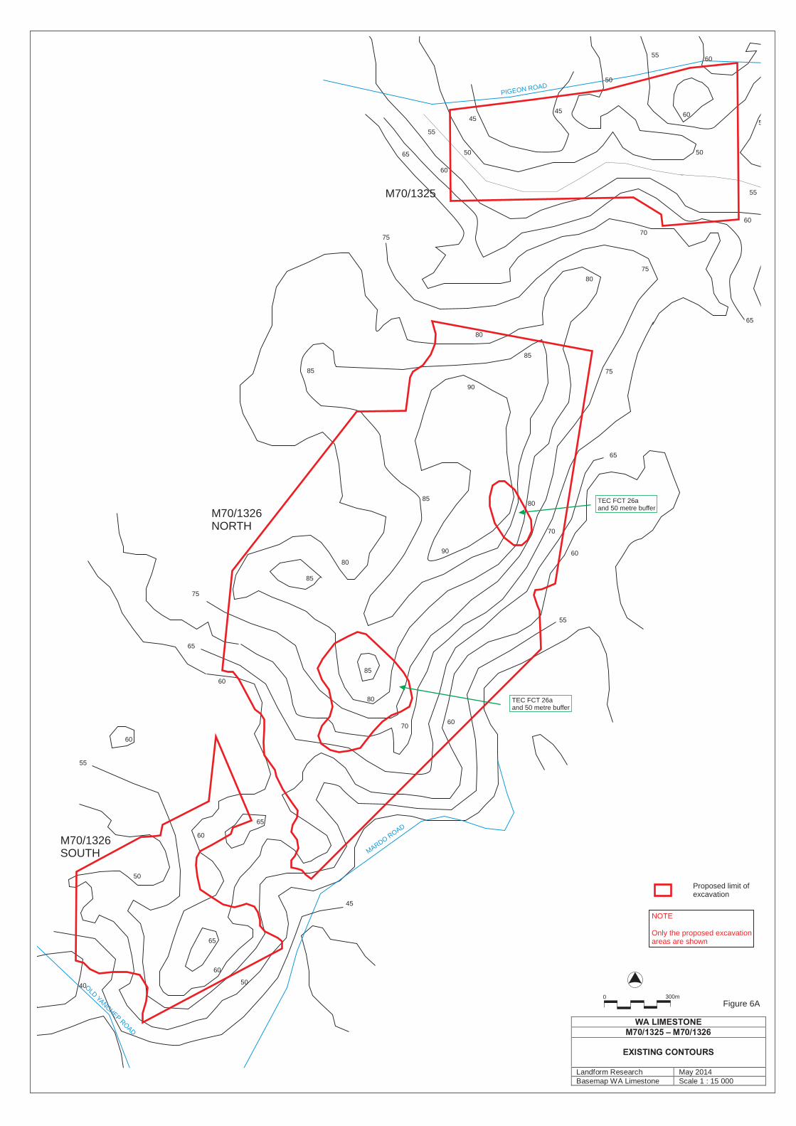
40
50
50
60
60
60
60
60
70
70
80
80
80
80
90
90 60
85
85
85
85
85
75
75
75
65
65
65
65
55
55
45
85
85
85
85
85
65
40
40
40
40
40
40
50
5050
50
50
60
60
70
70
70
70
80
80
80
90
90
90
90
90
90
60
60
60
60
60
60
60
60
85
75
75
75
75
75
65
65
65
55
55
55
55
55
55
55
45
45
45
45
45
4545
40
WA LIMESTONEM70/1325 – M70/1326
EXISTING CONTOURS
Landform Research May 2014Basemap WA Limestone Scale 1 : 15 000
Figure 6A0 300m
OLD
YANCHEP R
OAD
MARDO ROAD
PIGEON ROAD
M70/1325
M70/1326NORTH
M70/1326SOUTH
TEC FCT 26aand 50 metre buffer
TEC FCT 26aand 50 metre buffer
NOTE
Only the proposed excavationareas are shown
Proposed limit of excavation

40
50
50
60
60
60
60
60
70
70
80
80
80
80
90
90 60
85
85
85
85
85
75
75
75
65
65
65
65
55
55
45
85
85
85
85
85
65
40
40
40
40
40
40
50
5050
50
50
60
60
70
70
70
70
80
80
80
90
90
90
90
90
90
60
60
60
60
60
60
60
60
85
75
75
75
75
75
65
65
65
55
55
55
55
55
55
55
45
45
45
45
45
4545
40
WA LIMESTONEM70/1325 – M70/1326
EXISTING CONTOURS
Landform Research May 2014Basemap WA Limestone Scale 1 : 15 000
Figure 6A0 300m
50
50
55
65
70
70
45
45
40
70
80
80
90
85
85
75
65
45
50
50
50
50
50
55
55
55
55
55
55
55
55
55
55
55
55
55
60
60
60
60
60
60
60
65
65
65
65
65
65
70
70
70
70
70
70
75
75
75
75
75
75
75
80
80
80
80
80
80
80
85
85
85
85
85
85
85
45
45
45
45
45
45
45
40
40
40
40
40
55
55
55
50
50
50
45
45
4540
40
40
35
35
35
Figure 6B0 300m
WA LIMESTONEM70/1325 – M70/1326
CONCEPT FINAL CONTOURS
Landform Research May 2014Basemap WA Limestone Scale 1 : 15 000
OLD
YANCHEP R
OAD
MARDO ROAD
PIGEON ROAD
M70/1325
M70/1326NORTH
M70/1326SOUTH
TEC FCT 26aand 50 metre buffer
TEC FCT 26aand 50 metre buffer
NOTE
Only the proposed excavationareas are shown
Proposed limit of excavation

Typical sand pit and excavation
FIGURE 7
Excavating sand from a face similar to the proposed operation
WA LIMESTONEM70/1325
TYPICAL SAND EXCAVATIONS
Landform Research May 2014Basemap Scale

O
O
O
O
O
O
X
X
X
X
X
X
X
X
Overburden pushed into perimeter bundsfor later use in rehabilitation.The bunds assist dust and noisemitigation.
Topsoil pushed into lowdumps for use in rehabilitation.
Topsoil pushed into lowdumps for use in rehabilitation.
Excavation is normally 5 - 15 plus metres deep
+
++++
+++ +++
++ ++
Fill is compacted
TYPICAL SAND EXTRACTION
PROPOSED REHABILITATION AND REVEGETATION
ALTERNATIVE REHABILITATION TO PINES IN ASSOCIATION WITH FOREST PRODUCT COMMISSION
Loader loads directly to road truck
Excavator
Excavator or loader may be used for excavation and loading
Mobile screen may be usedto sort specialty sands
Loader
Loader
Existing BanksiaWoodland andpine plantation.
Existing heath and shrub
Existing heath and shrub
The quarry floor is deep ripped and covered by overburden followed by topsoil
The quarry floor is deep ripped and covered by overburden followed by topsoil
Revegetation using topsoil, tube plants collected and purchased local provenance seed.
Reconstructed limestone plant communities
Reconstructed soils suitable for pinesif required by Forest Products Commission
NOTE
At this stage Forest Products Commissionhave not indicated whether they wish toreplant pines on M70/1325.
If FPC do not want pines, rehabilitation will be to Banksia Woodland which is proposed.
Figure 8
WA LIMESTONEM70/1325
PROPOSED EXCAVATION METHODS
Landform Research May 2014Basemap Scale

M70/1325
M70/1326
Protects Tuart Woodland
Protects Threatened Community Type 26awith 50 metre setback
Protects newly recorded Threatened Community Type 26a with 50 metre setback
Located at the eastern edge of identifiedpossible extension to Yanchep National Park.
Felled pine plantation
Access
Access
Access
0
300m
Initial site facilitieslocation
Initial site facilitieslocation
WA LIMESTONEM70/1325 – M70/1326
AERIAL PHOTOGRAPH
Landform Research May 2014Basemap WA Limestone Scale 1 : 15 000
Figure 9