Mining-induced ground deformations - itasca.se · Eurock 2012 Page 2 1 INTRODUCTION The LKAB mining...
14
Eurock 2012 Page 1 Mining-induced ground deformations in Kiruna and Malmberget Britt-Mari Stöckel LKAB, Kiruna, Sweden Jonny Sjöberg Itasca Consultants AB, Luleå, Sweden Karola Mäkitaavola LKAB, Kiruna, Sweden Tomas Savilahti LKAB, Malmberget, Sweden Abstract: Ore extraction using sublevel caving is cost effective but results in successive caving of the host rock and mining-induced ground deformations. As a consequence, a continuous urban transformation has been in progress in the Kiruna and Malmberget municipalities ever since iron ore extraction in industrial scale commenced more than 100 years ago. The effects on the surroundings and the associated urban transformation are strategically important for LKAB in the future. This paper presents a status report concerning large-scale rock stability and effects on the surroundings due to sublevel caving in the LKAB mines, including currently on- going and planned rock mechanical activities within this subject area. These activities include: (i) monitoring of ground deformations using GPS and InSAR techniques, (ii) prognoses of mining-induced ground deformationns, and (iii) current and future planned research and development projects within this subject area. Theme: Mining Rock Mechanics Keywords: Sublevel caving, hangingwall deformations, GPS, InSAR, prognosis
Transcript of Mining-induced ground deformations - itasca.se · Eurock 2012 Page 2 1 INTRODUCTION The LKAB mining...

Eurock 2012 Page 1
Mining-induced ground deformations in Kiruna and
Malmberget
Britt-Mari Stöckel
LKAB, Kiruna, Sweden
Jonny Sjöberg
Itasca Consultants AB, Luleå, Sweden
Karola Mäkitaavola
LKAB, Kiruna, Sweden
Tomas Savilahti
LKAB, Malmberget, Sweden
Abstract: Ore extraction using sublevel caving is cost effective but results in
successive caving of the host rock and mining-induced ground deformations. As a
consequence, a continuous urban transformation has been in progress in the Kiruna
and Malmberget municipalities ever since iron ore extraction in industrial scale
commenced more than 100 years ago. The effects on the surroundings and the
associated urban transformation are strategically important for LKAB in the future.
This paper presents a status report concerning large-scale rock stability and effects on
the surroundings due to sublevel caving in the LKAB mines, including currently on-
going and planned rock mechanical activities within this subject area. These activities
include: (i) monitoring of ground deformations using GPS and InSAR techniques,
(ii) prognoses of mining-induced ground deformationns, and (iii) current and future
planned research and development projects within this subject area.
Theme: Mining Rock Mechanics
Keywords: Sublevel caving, hangingwall deformations, GPS, InSAR, prognosis

Eurock 2012 Page 2
1 INTRODUCTION
The LKAB mining company is extracting iron ore using the sublevel caving under-
ground mining method in the Kiruna and Malmberget mines. Both are world-class
mines with a combined total annual production of 45 Mtons of crude iron ore. Mining
using sublevel caving is cost-efficient and allows a high degree of mechanization and
automation. The method relies on caving of the hangingwall rock, which has the un-
fortunate side-effect that the ground surface on the hangingwall side continuously
deforms as a result of mining. Mining-induced ground deformations can also develop
on the footwall side, but to a lesser extent than on the hangingwall side, see Figure 1.
With increasing mining depths, larger portions of the hangingwall are affected
making it impossible to maintain any infrastructure or residential areas in these areas.
As a consequence, a continuous urban transformation has been in progress in the
Kiruna and Malmberget municipalities ever since iron ore extraction in industrial scale
commenced more than 100 years ago. During the last few years, this process has been
accentuated due to mining at larger depths and ground deformations progressed to-
ward critical infrastructure, e.g., the existing railroad in Kiruna. This will eventually
result in a more extensive urban transformation in both Kiruna and Malmberget.
Mining-induced deformations are of two types — continuous and discontinuous.
The discontinuous deformations are characterized by larger vertical and/or horizontal
movements accompanied by visible cracks on the ground surface. The continuous
deformations are characterized by a smooth deformation pattern, without sudden
"jumps" and with no visible cracks. Within the discontinuous zone, one can distin-
guish between the caved zone (caving of rock, large open cracks) and fracture zone
(visible cracks), see also Figure 1. The extension of these zones depend on e.g., the
distance from active mining to the ground surface, the geometry and dip of the ore-
body, pre-existing joints and structures in the rock mass, the mechanical properties of
the rock mass properties (strength and deformability) and the bulking of the caved
rock.
For the cases when the orebody is not daylighting, i.e., when there is a cap rock
between the orebody and the ground surface, the process is somewhat different. As the
sublevel cave mining progresses toward depth, the cap rock will cave and eventually,
a cave crater will form on the ground surface, see Figure 2. Once a cave crater has
formed, the deformation pattern is similar to that for a daylighting orebody. The time
delay between mining of a certain mining level and ground deformations is larger in
the case of a non-daylighting orebody. This situation is common in the Malmberget
mine, where several orebodies are non-daylighting, with various degrees of surface
caving (see e.g., Wettainen et al., 2011). For the Kiruna case, the major orebody being
mined is the Kiirunavaara orebody, which is approximately 4 km long, striking nearly
north-south and dipping around 60° toward east (toward the city of Kiruna). A cave
crater has developed above the mined orebody, see Figure 3. In the northern portion,
however, the orebody is non-daylighting, extending under a (now drained) lake. This
portion of the ore is called "Sjömalmen" (the Lake Orebody).
The municipalities of Kiruna and Malmberget are thus unavoidably affected by
the mining activities. To be able to plan for an urban transformation it is necessary to
have a prognosis of the mining-induced ground deformations (with time — coupled to
mining progress). The LKAB rock mechanics strategic plan describes the required
rock mechanics work for the next 3–5 years, as well as suggestion for more long-term
rock mechanics research and development (5–15 year time frame). One of the focus
areas of this plan is the mining-induced ground deformations and associated effects.
The following objectives and long-term goals have been defined for this work:

Eurock 2012 Page 3
1. Develop prognosis and description of consequences for the time frame 0–10 years
with a maximum error of 2 years (in terms of predicted location of deformation
limits).
2. Develop prognosis and description of consequences for the time frame 10–20
years with a maximum error of 3–5 years (in terms of predicted location of defor-
mation limits).
3. Develop prognosis and description of consequences for the time frame 20 years
and longer based on the currently known ore reserves.
Ore- body
Hangingwall Footwall
Caved rock
Deformation Zone Fracture
Zone Caving Zone
Fracture Zone
Deformation Zone
Continuous deformations
Discontinuous deformations
Continuous deformations
Figure 1. Schematic figure showing mine-induced fracturing and deformations on the hangingwall-
and footwall side of a sublevel caving operation.
Orebody
Plunge hangingwall
Plunge footwall
Caved rock
Deformation Zone
Fracture Zone
Caving Zone
Fracture Zone
Mining level
Deformation Zone
Cap rock
Figure 2. Schematic figure showing mine-induced fracturing and deformations above a "blind" (non-daylighting) orebody.

Eurock 2012 Page 4
Figure 3. Aerial view of Kiruna (view toward north) with the caving crater above the Kiirunavaara
orebody to the west and the municipality to the east, as of 2010.
In the shorter perspective, extensive monitoring of the development of deformations
on the ground surface is required, including development of the measurement tech-
niques. Currently on-going and planned rock mechanical activities within this subject
area are further described in this paper.
2 MONITORING OF GROUND DEFORMATIONS
2.1 Measurements and observations
The development of the mining-induced ground deformations is currently being moni-
tored by using GPS and fixed measurement hubs. The same techniques are used in
both Kiruna and Malmberget. The GPS-measurements in Kiruna started in 2003 and
were preceded by geodetic measurements using total station (1994–2002) and
Mekometer (electronic distance measurements) and precision leveling (1976–1994).
As of September 2011, there are 333 measurement hubs installed on the hangingwall
ground surface. In Malmberget, GPS-measurements started in 2009 and currently, 226
measurements hubs are installed.
The GPS measurement technique is the currently most suitable method with
respect to both good precision and large areal coverage, as well as ease of application.
LKAB uses so-called relative measurements and network RTK for GPS, which
provides more reference points during measurement and an improved precision. A
control of the practical repeatability in measurements in Kiruna showed a horizontal
precision of 0.7 cm and a vertical precision of 1.3 cm. These values do not include
effects of e.g., groundwater changes, climatic conditions (temperature, frost heave),
etc. Currently, all measurements hubs are installed by placing a steel casing in a 140
mm borehole down to a depth of at least 5 m (frost free ground or to solid rock). A
measurement pin is placed at the center of the casing and the casing is grouted with
concrete, see Figure 4. As mining progresses toward depth and larger areas are
affected on the surface, the monitoring network is continuously enlarged and new
measurement hubs installed at an early stage to capture initial mining-induced ground
deformations.
Hangingwall side
Kiruna City
Railroad
North

Eurock 2012 Page 5
Figure 4. Aerial photography of Kiruna showing part of the system for GPS-measurements of
deformations and results from the latest measurement.
Repeated measurements on the same measurement hub with a certain time interval
allow both horizontal and vertical deformations to be registered. In Kiruna, measure-
ments are taken quarterly, but all measurement hubs are only measured once per year
(during June). For the other three quarters (normally in September, December and
March), strategically important measurement hubs are measured. This includes all
hubs located near (on both sides) of the two deformation limits defined (see below).
Normally, the development of displacements is slow and these quarterly measure-
ments should be viewed as complement to the annual measurement of all hubs. In
Malmberget, the same measurement frequency is applied but no deformation limits are
yet defined.
The two deformation limits used for presenting the results for Kiruna are termed
"movement indicated" and "environmental criterion". The limit "movement indicated"
corresponds to an accumulated horizontal deformation of 0.02 m for at least two sub-
sequent measurements, since the start of monitoring. This limit corresponds to the
practically achievable precision for GPS-measurements of horizontal ground displace-
ments (the vertical precision is lower than this). The limit "environmental criterion" is
used since 2009, following a ruling by the Environmental Court in Sweden. This crite-
rion specifies that the ground surface (outside the industrial area) is only allowed to
deform corresponding to a maximum of 3 ‰ horizontal strain and 2 ‰ vertical strain
("tilt"), verified at two subsequent measurements between measurement hubs along a
specified line (Figure 5).

Eurock 2012 Page 6
Figure 5. Environmental criterion for maximum allowable influence on the ground surface from mining — example calculation.
This criterion is thus formulated in terms of relative movement and location of this
limit is an important planning consideration for LKAB, as the company is not allowed
to exceed this limit for areas outside the fenced-in industrial area, meaning that LKAB
has to plan ahead to continuously expand the industrial area as ground displacements
become more widespread. The results from the GPS measurements are reported
quarterly (following each measurement) both internally and externally. The latter
include the regulators ("Länsstyrelsen"), the municipality of Kiruna ("Kiruna
kommun") and other parties that may be affected by the mining-induced deformations.
Extensometer measurements have been used in a few cases to monitor critical in-
stallations. One such case is the monitoring of the existing railroad in Kiruna. The
results have proven to be difficult to interpret, with most of the extensometers not
showing any movement at all, and the practical usefulness of these measurements is
limited. The occurrence of seismic events is monitored using the mine-wide seismic
network systems in the Kiruna and Malmberget mines. While not optimized to moni-
tor caving progression, the systems allow, in any case, detection of increased seismic
activity in the hangingwall, which may be taken as a sign of new caving occurring.
Such observations can then be used to trigger additional inspections and/or ground
surface deformation measurements.
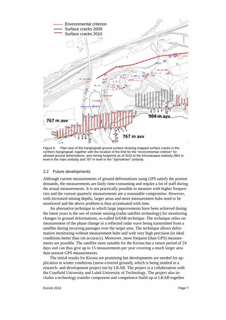
The development of the fracture and caving zones on the surface is followed up
through annual surface crack mapping (since 2005). The mapping is conducted in
early summer each year and includes documenting all visible cracks on the ground
surface (in areas that are safe to map, i.e., with not too large caving deformations).
The first visible cracks are small (mm size), although the measured ground defor-
mations can be fairly large (typically 20-30 cm) horizontal deformation at the location
of the first visible cracks. The cracks are mainly parallel to the orebody strike, but this
also means that the surface cracks follow the ore boundaries at the end of the orebody
in the north and south. All the mapped cracks are marked on maps (see example in
Figure 6) and a report is published each year with text and photo documentation of
each crack.
M2M1
Example: distance 50 m
max
10 cm
max
15 cm
- more secure measurement values
- shows whether mining is the cause
- coupled to impact
Eurock 2012 Page 7
Figure 6. Plan view of the hangingwall ground surface showing mapped surface cracks in the
northern hangingwall, together with the location of the limit for the "environmental criterion" for allowed ground deformations, and mining footprints as of 2010 in the Kiirunavaara orebody (964 m level in the main orebody and 767 m level in the "Sjömalmen" orebody.
2.2 Future developments
Although current measurements of ground deformations using GPS satisfy the present
demands, the measurements are fairly time-consuming and require a lot of staff during
the actual measurements. It is not practically possible to measure with higher frequen-
cies and the current quarterly measurements are a reasonable compromise. However,
with increased mining depths, larger areas and more measurement hubs need to be
monitored and the above problem is thus accentuated with time.
An alternative technique in which large improvements have been achieved during
the latest years is the use of remote sensing (radar satellite technology) for monitoring
changes in ground deformations, so-called InSAR-technique. The technique relies on
measurement of the phase change in a reflected radar wave being transmitted from a
satellite during recurring passages over the target area. The technique allows defor-
mation monitoring without measurement hubs and with very high precision (in ideal
conditions better than cm accuracy). Moreover, more frequent (than GPS) measure-
ments are possible. The satellite most suitable for the Kiruna has a return period of 24
days and can thus give up to 15 measurements per year covering a much larger area
than present GPS measurements.
The initial results for Kiruna are promising but developments are needed for ap-
plication in winter conditions (snow-covered ground), which is being studied in a
research- and development project run by LKAB. The project is a collaboration with
the Cranfield University and Luleå University of Technology. The project also in-
cludes a technology transfer component and competence build-up at LKAB together
964 m avv767 m avv
767 m avv
Environmental criterion
Surface cracks 2009
Surface cracks 2010

Eurock 2012 Page 8
with the supplier MDA. LKAB is investing around 20 million SEK in the project,
which has been on-going for two years. The project is scheduled to run for another
three years after which an evaluation of the applicability (and possible future use) of
InSAR for the conditions in Kiruna (and possibly Malmberget) will be made.
3 PROGNOSIS OF GROUND DEFORMATIONS
3.1 Previous prognosis work
Caving and ground deformations induced by sublevel caving is a well-known phe-
nomenon. There are several cases in Sweden (where sublevel caving has been fre-
quently used for underground iron ore mining) where nearby municipalities have been
affected by mining-induced ground deformations. In Grängesberg, the so-called
"Brewery Fault" (named so because it was daylighting near the local brewery) was
activated by mining. Internationally, there exist a vast amount of data and experience
of ground subsidence from coal mining, but the rock conditions and the mining meth-
ods employed are very different from hard rock sublevel caving and the governing
mechanisms are thus also quite different. These experiences are thus of limited ap-
plicability to the Kiruna and Malmberget cases. The international experience and
knowledge relating to sublevel caving and mining-induced deformations resulting in
an urban transformation is fairly limited.
A literature review of published studies on sublevel caving subsidence was pre-
sented by Villegas (2008). A majority of these studies involve the use of analytical
limit equilibrium tools as a basis for prediction of stability and surface cracking.
Numerical analysis has not been used to any larger extent until more recently. The
numerical models used have, for several cases, sought to be calibrated against meas-
ured ground deformations and observed cracking. Common to almost all studies pub-
lished is that the underlying mechanisms are still not completely known, which largely
is due to the poor knowledge of the rock mass conditions in these large volumes in-
volved and the difficulties involved in observing and measuring the behavior under-
ground (in the hangingwall). More recently, there have been some significant ad-
vances in the use of numerical models to predict caving and surface disturbances, as
summarized by Sainsbury et al. (2011).
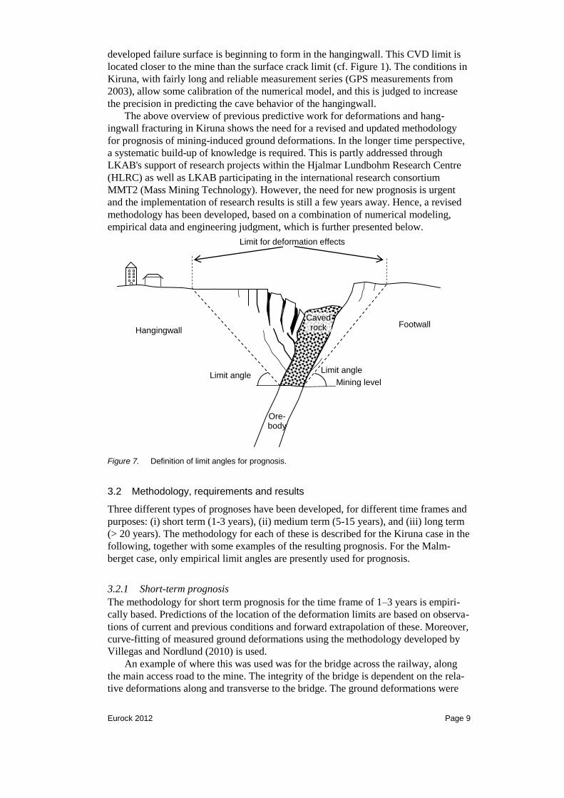
Previous prognoses for the Kiruna case have primarily been based on limit equi-
librium analysis assuming rigid body movement, sometimes used in conjunction with
empirical criteria, mostly so-called break angles. The break angle is defined as the
angle from the horizontal to a line from the active mining level to the outermost ob-
served surface crack. This definition can be made more general by using the term
"limit angle", defined as the angle to a defined limit on the ground surface, e.g., cracks
or a certain measured deformation value, see Figure 7. The precision in these previous
predictions varies, but can generally be said to be poor — in some cases being too
conservative and in other cases being un-conservative.
A likely cause of this discrepancy is that any limit equilibrium method assumes
that failure is fully developed and the shear strength along the failure surface is fully
(and equally) mobilized at the time of slip. It can thus be anticipated that a prognosis
based on limit equilibrium analysis can, at best, be used to estimate the location of a
failure surface (which surface cracking may be an indication of), but not to predict the
location of the limit of measurable mining-induced ground deformations.
Villegas (2008) and Villegas & Nordlund (2008) presented a methodology based
on numerical modeling in which the cave development was simulated in a novel way.
The analyses were calibrated against measurements and observations and allowed the
failure limit to be predicted. The failure limit was assumed to correspond to a "Critical
Vertical Deformation" (CVD) and can be taken to represent the stage at which a fully
Eurock 2012 Page 9
developed failure surface is beginning to form in the hangingwall. This CVD limit is
located closer to the mine than the surface crack limit (cf. Figure 1). The conditions in
Kiruna, with fairly long and reliable measurement series (GPS measurements from
2003), allow some calibration of the numerical model, and this is judged to increase
the precision in predicting the cave behavior of the hangingwall.
The above overview of previous predictive work for deformations and hang-
ingwall fracturing in Kiruna shows the need for a revised and updated methodology
for prognosis of mining-induced ground deformations. In the longer time perspective,
a systematic build-up of knowledge is required. This is partly addressed through
LKAB's support of research projects within the Hjalmar Lundbohm Research Centre
(HLRC) as well as LKAB participating in the international research consortium
MMT2 (Mass Mining Technology). However, the need for new prognosis is urgent
and the implementation of research results is still a few years away. Hence, a revised
methodology has been developed, based on a combination of numerical modeling,
empirical data and engineering judgment, which is further presented below.
Ore-body
Hangingwall Footwall
Caved rock
Limit for deformation effects
Limit angle Limit angle
Mining level
Figure 7. Definition of limit angles for prognosis.
3.2 Methodology, requirements and results
Three different types of prognoses have been developed, for different time frames and
purposes: (i) short term (1-3 years), (ii) medium term (5-15 years), and (iii) long term
(> 20 years). The methodology for each of these is described for the Kiruna case in the
following, together with some examples of the resulting prognosis. For the Malm-
berget case, only empirical limit angles are presently used for prognosis.
3.2.1 Short-term prognosis
The methodology for short term prognosis for the time frame of 1–3 years is empiri-
cally based. Predictions of the location of the deformation limits are based on observa-
tions of current and previous conditions and forward extrapolation of these. Moreover,
curve-fitting of measured ground deformations using the methodology developed by
Villegas and Nordlund (2010) is used.
An example of where this was used was for the bridge across the railway, along
the main access road to the mine. The integrity of the bridge is dependent on the rela-
tive deformations along and transverse to the bridge. The ground deformations were

Eurock 2012 Page 10
predicted using the curve-fitting presented by Villegas and Nordlund (2010), in which
polynomial curve fits (deformation as a function of X-coordinate) were made for each
measurement line of the GPS monitoring program. Thus, the ground deformations
near each of the pillars of the bridge could be predicted and the relative deformations
calculated. This then served as input to an assessment of the stability of the bridge
when subjected to various deformation scenarios.
Another example of a short-term prognosis concerns the existing railroad in
Kiruna. The construction of the new railroad is underway, with a target completion
date of October 2012 (when the railroad should open for traffic). During 2010, the
issue was raised of whether this target date was sufficient, in light of increasing defor-
mations and cracking observed on the hangingwall. At that time, it was still possible to
shorten the construction time (for an earlier start date for traffic), f this should be re-
quired. An "expert group" had been formed previously, with representatives from
LKAB, Trafikverket (The Swedish Transport Administration) and Ltu (Luleå Univer-
sity of Technology) with the objective of continuously monitoring the progression of
surface cracking and ground deformations to reduce the uncertainty regarding sudden
(and unexpected) ground deformations that could cause damage to the existing rail-
road. During 2010, the "expert group" performed a detailed joint assessment of all
available information to estimate whether the existing railroad would be affected be-
fore October 2012. The basic assumption made was that it was very likely that the
existing railroad can be used safely as long as the deformations are continuous (i.e.,
without sudden "jumps") and no visible cracks have been detected in this area.
Using previous observations of the distance between the first visible crack and the
railroad for the years of 2005 to 2010, a prognosis for when the first visible crack
would appear in the railroad area was made. Under the assumption that the variability
in previous data corresponded to one standard deviation, the probability of the first
crack reaching the railroad by mid-2012 was 67 %. However, the deformation data
showed that the magnitude of measured ground deformations is fairly similar (and still
continuous) within a zone of approximately 40 m behind (toward the mine) the first
crack. Hence, an additional safety margin of some 40 m, relative to the first crack,
applies. With the current progression of the ground deformations, this corresponds to
around 1 year in time. Based on this, the "expert group" concluded that a traffic start
date of October 2012 was sufficient, but that continued monitoring and inspection
should be undertaken.
3.2.2 Medium-term prognosis
For the medium term time frame (5–15 years), a new methodology for prognosis was
developed in 2009. The methodology is based on a combination of analysis of meas-
urement data, numerical modeling, and empirical relations, as follows (cf. Figure 8):
Two-dimensional numerical modeling to determine the failure limit.
The methodology used by Villegas & Nordlund (2008) was used with renewed
calibration against measurements and crack observations. The failure limit was
assumed to represent a fully developed failure surface in the hangingwall and a so-
called Critical Vertical Deformation (CVD) on the ground surface.
Deformation pattern — empirical analysis.
The curve-fitting of measured deformations according to Villegas (2010) and
Villegas & Nordlund (2010) were used to estimate the limits for the progression of
the deformation area ("movement indicated" and "environmental criterion").
Empirical limit angles.
Empirical data on limit angles for the location of the limit for "movement indi-
cated" and "environmental criterion" based on previous observations (starting
2003) were used to define design values for limit angles.
Eurock 2012 Page 11
Three-dimensional numerical modeling of "Sjömalmen".
A first attempt at three-dimensional cave-scale numerical modeling was made for
the "Sjömalmen" area. The model was used for preliminary analysis of the effects
of future mining in "Sjömalmen", following initial calibration of the model
(Hakami, et al., 2010)'
Ore-body
Hangingwall
Footwall
Caved rock
Active mining level
Fully developed failure surface
CVD
GPS hub
Limit angles
Figure 8. Methodology for prognosis of ground deformations of the Kiirunavaara hangingwall — limit states and influences on ground behavior.
Different methods are more or less suited for prognosis of the different limit states, but
there is currently no single method that can be used to predict all aspects of the caving
and failure process. A combination of numerical and empirical methods, used in con-
junction with engineering judgment proved to be necessary. This combined assess-
ment also included a valuation of the reliability and representativity of each dataset
and analysis method.
A prognosis was made for the years 2013, 2018, and 2023 (the year 2013 had been
used in previous prognoses and was thus a good starting point, and the others were
chosen with five-year intervals). In developing the final prognosis, the results from
each of the four approaches above were used. The predicted limits (for "movement
First visible crack
Failure limit
"Environmental
criterion"
"Movement
indicated"
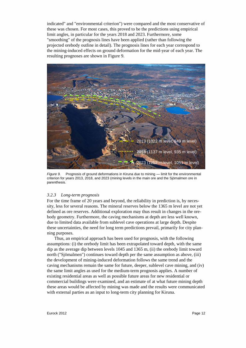
Eurock 2012 Page 12
indicated" and "environmental criterion") were compared and the most conservative of
these was chosen. For most cases, this proved to be the predictions using empirical
limit angles, in particular for the years 2018 and 2023. Furthermore, some
"smoothing" of the prognosis lines have been applied (rather than following the
projected orebody outline in detail). The prognosis lines for each year correspond to
the mining-induced effects on ground deformation for the mid-year of each year. The
resulting prognoses are shown in Figure 9.
Figure 9. Prognosis of ground deformations in Kiruna due to mining — limit for the environmental criterion for years 2013, 2018, and 2023 (mining levels in the main ore and the Sjömalmen ore in
parenthesis.
3.2.3 Long-term prognosis
For the time frame of 20 years and beyond, the reliability in prediction is, by neces-
sity, less for several reasons. The mineral reserves below the 1365 m level are not yet
defined as ore reserves. Additional exploration may thus result in changes in the ore-
body geometry. Furthermore, the caving mechanisms at depth are less well known,
due to limited data available from sublevel cave operations at large depth. Despite
these uncertainties, the need for long term predictions prevail, primarily for city plan-
ning purposes.
Thus, an empirical approach has been used for prognosis, with the following
assumptions: (i) the orebody limit has been extrapolated toward depth, with the same
dip as the average dip between levels 1045 and 1365 m, (ii) the orebody limit toward
north ("Sjömalmen") continues toward depth per the same assumption as above, (iii)
the development of mining-induced deformation follows the same trend and the
caving mechanisms remain the same for future, deeper, sublevel cave mining, and (iv)
the same limit angles as used for the medium-term prognosis applies. A number of
existing residential areas as well as possible future areas for new residential or
commercial buildings were examined, and an estimate of at what future mining depth
these areas would be affected by mining was made and the results were communicated
with external parties as an input to long-term city planning for Kiruna.
2013 (1022 m level, 849 m level)
2018 (1137 m level, 935 m level)
2023 (1252 m level, 1051 m level)
Eurock 2012 Page 13
3.2 Validity, reliability and review process
The prognoses presented above rests on the following assumptions and data:
Known ore reserves at the time of analysis.
Mine plan (future schedule) at the time of the analysis.
The prognosis lines on the ground surface are assumed to correspond to an in-
stantaneous deformation effect from mining of a certain mining level for a specific
year (i.e., any possible time delays in the caving behavior are ignored).
Prognoses are updated when new information is obtained or if observations show a
different caving behavior or deformation pattern than predicted. A procedure for re-
view and (if required) revision of prognoses has been adopted within LKAB. All prog-
noses work is documented in a report, which describes the basis for prognosis, results,
and major changes from previous prognoses. An annual review of all prognoses is
undertaken, which should include a comparison with measurements and observations.
An updated/revised prognosis may be developed, should large discrepancies be found,
or new knowledge has arisen. It should also be mentioned that prognosis methodology
has been audited by international expertise and been found to represent the "state-of-
the-art" with respect to its purpose and application, and that the underlying data was
found to be of good quality and extent.
The reliability of the prognosis has been estimated qualitatively. Generally speak-
ing, the uncertainties are larger in the "Sjömalmen" area. The effects on the ground
surface will largely depend on whether caving reaches the ground surface, and the
existing cave crater is enlarged, as mining progresses deeper. If this is not the case, a
significantly smaller area of impact is anticipated. There is also a likely a significant
time delay for mining of this non-daylighting orebody, which may increase as mining
goes deeper.
An attempt at quantifying the uncertainty in the prognoses has been made. For the
year 2013 the estimated uncertainty is ± 50 m for the location of both deformation
limits ("movement indicated" and "environmental criterion"), whereas for the years
2018 and 2023, an uncertainty of ± 100 m applies. For the long term prognosis, an
even higher uncertainty is likely, but this has not been estimated.
4 DISCUSSION AND CONCLUSIONS
The on-going urban transformation in Kiruna and Malmberget can be viewed as full-
scale test of the rock mass strength and deformability behavior, as well as a test of the
societal organizational and planning functions. Although the urban transformation has
been in progress since the start of mining in both these municipalities, the demands on
the planning process and the cooperation between all affected parties, is larger than
ever today.
Prediction of mining-induced ground deformations is essential to be able to plan
for the urban transformation that will result. The work presented in this paper de-
scribes the current status of prognosis. The combination of empirical and numerical
analysis was necessary to develop the medium- and long-term prognoses. The en-
gineering judgment used to combine the results was important, but also introduces an
element of subjectivity. The annual review procedure described above is thus very
important to continuously assess (and if necessary, revise) the assumptions and deci-
sions made.
In the short time perspective, extensive monitoring of the deformation develop-
ment is required along with further development of the measurement technique.
Continued GPS-monitoring of surface measurement hubs on the hangingwall side
should be carried out, including extending the monitoring network to areas that will be
affected in the future. For the "Sjömalmen" area, supplementary monitoring of the

Eurock 2012 Page 14
hangingwall is recommended. Such monitoring could include TDR-cables and an
extended seismic array (toward the Kiruna township) to improve the knowledge of the
caving behavior.
The precision in prediction needs improvement and several on-going activities
may help in achieving this. LKAB is currently sponsoring two PhD-projects at the
Luleå University of Technology, concerning hangingwall stability. These projects will
be completed in 2011-2012. For the Malmberget mine, a similar study is being con-
ducted on the stability and ground deformations of crown pillars above non-daylight-
ing orebodies. Moreover, LKAB's participation in the MMT2 research project has
resulted in a more detailed cave-scale modeling study currently being performed for
"Sjömalmen" in Kiruna. It is envisioned that this will provide an improved prediction
of ground deformations and caving in this area, and help improve the knowledge on
how future caving in a non-daylighting orebody can develop.
REFERENCES
Hakami, E., Sainsbury, B-A., Mas Ivars, D. & Ekneligoda, T. 2010. Numerical
simulation of cave propagation and subsidence due to future mining of the Lake
Ore Body. LKAB Utredning TG 10-788. 2010-04-26.
Sainsbury, B. L., Sainsbury, D. P. & Pierce, M. E. 2011. A historical review of the
development of numerical cave propagation simulations. In Continuum and
Distinct Element Numerical Modeling in Geomechanics — 2011. Proc. 2nd
International FLAC/DEM Symposium (Melbourne, February 14–16, 2010), pp.
23–36. Minneapolis: Itasca International Inc.
Villegas, T. F. 2008. Numerical Analyses of the Hangingwall at the Kiirunavaara
Mine. Licentiate Thesis 2008:11, Division of Mining and Geotechnical
Engineering, Luleå University of Technology, Sweden.
Villegas, T. F. & Nordlund, E. 2008. Numerical analyses of the hangingwall failure at
the Kiirunavaara mine. Proc. MassMin 2008 5th International Conference and
Exhibition on Mass Mining (Luleå, June 9–11, 2008), pp. 729–838. Luleå: Luleå
University of Technology.
Villegas, T. & Nordlund, E. 2010. Investigation of Surface Subsidence Due to
Sublevel Caving. Proc. Caving 2010 (Perth, April 20–22, 2010), Perth: ACG
Wettainen, T., Sjöberg, J. & Dahnér, C. 2011. Analys och prognostisering av
uppblockning i Printzsköld. Bergmekanikdag 2011 - Föredrag (Stockholm, 14
mars 2011). Stockholm: Stiftelsen Bergteknisk Forskning – BeFo (in Swedish).