BEARING CAPACITY OF SHALLOW FOUNDATIONS of Shallow Foundation.
Upload
phungkhanhCategory
view
228download
1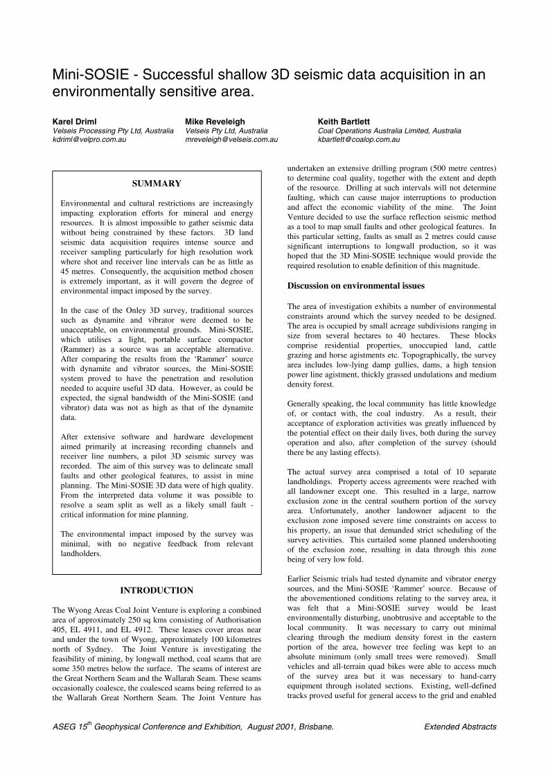
ASEG 15th Geophysical Conference and Exhibition, August 2001, Brisbane. Extended Abstracts
Mini-SOSIE - Successful shallow 3D seismic data acquisition in anenvironmentally sensitive area.
Karel Driml Mike Reveleigh Keith BartlettVelseis Processing Pty Ltd, Australia Velseis Pty Ltd, Australia Coal Operations Australia Limited, [email protected] [email protected] [email protected]
INTRODUCTION
The Wyong Areas Coal Joint Venture is exploring a combinedarea of approximately 250 sq kms consisting of Authorisation405, EL 4911, and EL 4912. These leases cover areas nearand under the town of Wyong, approximately 100 kilometresnorth of Sydney. The Joint Venture is investigating thefeasibility of mining, by longwall method, coal seams that aresome 350 metres below the surface. The seams of interest arethe Great Northern Seam and the Wallarah Seam. These seamsoccasionally coalesce, the coalesced seams being referred to asthe Wallarah Great Northern Seam. The Joint Venture has
undertaken an extensive drilling program (500 metre centres)to determine coal quality, together with the extent and depthof the resource. Drilling at such intervals will not determinefaulting, which can cause major interruptions to productionand affect the economic viability of the mine. The JointVenture decided to use the surface reflection seismic methodas a tool to map small faults and other geological features. Inthis particular setting, faults as small as 2 metres could causesignificant interruptions to longwall production, so it washoped that the 3D Mini-SOSIE technique would provide therequired resolution to enable definition of this magnitude.
Discussion on environmental issues
The area of investigation exhibits a number of environmentalconstraints around which the survey needed to be designed.The area is occupied by small acreage subdivisions ranging insize from several hectares to 40 hectares. These blockscomprise residential properties, unoccupied land, cattlegrazing and horse agistments etc. Topographically, the surveyarea includes low-lying damp gullies, dams, a high tensionpower line agistment, thickly grassed undulations and mediumdensity forest.
Generally speaking, the local community has little knowledgeof, or contact with, the coal industry. As a result, theiracceptance of exploration activities was greatly influenced bythe potential effect on their daily lives, both during the surveyoperation and also, after completion of the survey (shouldthere be any lasting effects).
The actual survey area comprised a total of 10 separatelandholdings. Property access agreements were reached withall landowner except one. This resulted in a large, narrowexclusion zone in the central southern portion of the surveyarea. Unfortunately, another landowner adjacent to theexclusion zone imposed severe time constraints on access tohis property, an issue that demanded strict scheduling of thesurvey activities. This curtailed some planned undershootingof the exclusion zone, resulting in data through this zonebeing of very low fold.
Earlier Seismic trials had tested dynamite and vibrator energysources, and the Mini-SOSIE ‘Rammer’ source. Because ofthe abovementioned conditions relating to the survey area, itwas felt that a Mini-SOSIE survey would be leastenvironmentally disturbing, unobtrusive and acceptable to thelocal community. It was necessary to carry out minimalclearing through the medium density forest in the easternportion of the area, however tree feeling was kept to anabsolute minimum (only small trees were removed). Smallvehicles and all-terrain quad bikes were able to access muchof the survey area but it was necessary to hand-carryequipment through isolated sections. Existing, well-definedtracks proved useful for general access to the grid and enabled
SUMMARY
Environmental and cultural restrictions are increasinglyimpacting exploration efforts for mineral and energyresources. It is almost impossible to gather seismic datawithout being constrained by these factors. 3D landseismic data acquisition requires intense source andreceiver sampling particularly for high resolution workwhere shot and receiver line intervals can be as little as45 metres. Consequently, the acquisition method chosenis extremely important, as it will govern the degree ofenvironmental impact imposed by the survey.
In the case of the Onley 3D survey, traditional sourcessuch as dynamite and vibrator were deemed to beunacceptable, on environmental grounds. Mini-SOSIE,which utilises a light, portable surface compactor(Rammer) as a source was an acceptable alternative.After comparing the results from the ‘Rammer’ sourcewith dynamite and vibrator sources, the Mini-SOSIEsystem proved to have the penetration and resolutionneeded to acquire useful 3D data. However, as could beexpected, the signal bandwidth of the Mini-SOSIE (andvibrator) data was not as high as that of the dynamitedata.
After extensive software and hardware developmentaimed primarily at increasing recording channels andreceiver line numbers, a pilot 3D seismic survey wasrecorded. The aim of this survey was to delineate smallfaults and other geological features, to assist in mineplanning. The Mini-SOSIE 3D data were of high quality.From the interpreted data volume it was possible toresolve a seam split as well as a likely small fault -critical information for mine planning.
The environmental impact imposed by the survey wasminimal, with no negative feedback from relevantlandholders.
3D Mini-SOSIE Driml,Reveleigh,Bartlett
ASEG 15th Geophysical Conference and Exhibition, August 2001, Brisbane. Extended Abstracts
the recording truck to set up in strategic locations. All felledtrees were chipped and the chips were left in place.
Figure 1: Areal photograph showing survey boundary
2D Seismic trial
A 2D seismic trial took place in November 1997. Thisconsisted of a single dynamite shot/receiver line and twoswath lines. The Mini-SOSIE system and electromagneticmini-vibrators were also utilised to re-record a section of thedynamite shot/receiver line. Velseis Pty Ltd using the samerecording instruments and geophones undertook all recording.
Vibroseis
MiniSOSIE
Dynamite
Power Spectrum
Power Spectrum
Power Spectrum
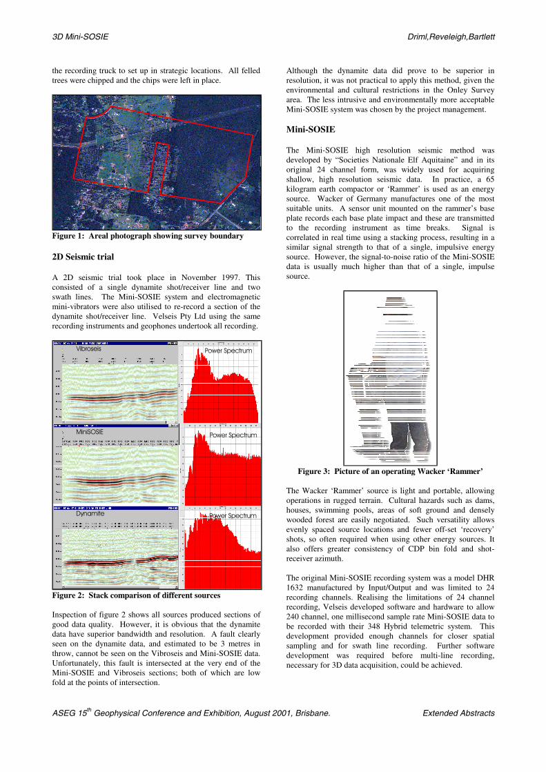
Figure 2: Stack comparison of different sources
Inspection of figure 2 shows all sources produced sections ofgood data quality. However, it is obvious that the dynamitedata have superior bandwidth and resolution. A fault clearlyseen on the dynamite data, and estimated to be 3 metres inthrow, cannot be seen on the Vibroseis and Mini-SOSIE data.Unfortunately, this fault is intersected at the very end of theMini-SOSIE and Vibroseis sections; both of which are lowfold at the points of intersection.
Although the dynamite data did prove to be superior inresolution, it was not practical to apply this method, given theenvironmental and cultural restrictions in the Onley Surveyarea. The less intrusive and environmentally more acceptableMini-SOSIE system was chosen by the project management.
Mini-SOSIE
The Mini-SOSIE high resolution seismic method wasdeveloped by “Societies Nationale Elf Aquitaine” and in itsoriginal 24 channel form, was widely used for acquiringshallow, high resolution seismic data. In practice, a 65kilogram earth compactor or ‘Rammer’ is used as an energysource. Wacker of Germany manufactures one of the mostsuitable units. A sensor unit mounted on the rammer’s baseplate records each base plate impact and these are transmittedto the recording instrument as time breaks. Signal iscorrelated in real time using a stacking process, resulting in asimilar signal strength to that of a single, impulsive energysource. However, the signal-to-noise ratio of the Mini-SOSIEdata is usually much higher than that of a single, impulsesource.
Figure 3: Picture of an operating Wacker ‘Rammer’
The Wacker ‘Rammer’ source is light and portable, allowingoperations in rugged terrain. Cultural hazards such as dams,houses, swimming pools, areas of soft ground and denselywooded forest are easily negotiated. Such versatility allowsevenly spaced source locations and fewer off-set ‘recovery’shots, so often required when using other energy sources. Italso offers greater consistency of CDP bin fold and shot-receiver azimuth.
The original Mini-SOSIE recording system was a model DHR1632 manufactured by Input/Output and was limited to 24recording channels. Realising the limitations of 24 channelrecording, Velseis developed software and hardware to allow240 channel, one millisecond sample rate Mini-SOSIE data tobe recorded with their 348 Hybrid telemetric system. Thisdevelopment provided enough channels for closer spatialsampling and for swath line recording. Further softwaredevelopment was required before multi-line recording,necessary for 3D data acquisition, could be achieved.

3D Mini-SOSIE Driml,Reveleigh,Bartlett
ASEG 15th Geophysical Conference and Exhibition, August 2001, Brisbane. Extended Abstracts
The 1999 Onley 3D Seismic Survey-data acquisition
The Onley 3D seismic survey covered an area of 1.4 Km² andcomprised 25 receiver lines and 18 source lines. The sourcelines totalled 28.62 kilometres, with 1908 source points.
Coal Operations Australia Limited supervised line clearingand was also responsible for permitting. Line clearingconsisted of a wheeled tractor/slasher in the more denselywooded areas with a slasher only, in the grassy and lightlywooded areas. More closely settled areas devoted to hobbyfarming required little or no clearing.
Recording operations commenced on 15/09/99 and werecompleted on 30/09/99 - a period of 16 days, of which 2 dayswere lost though permitting problems and rain. Recordingwas also slowed on some occasions due to strong winds. Thisdictated a greater source effort and the number of rams persegment (shot point) had to be increased in order to improvethe signal-to-noise ratio. The average recording productionwas 2 kilometres per day and the maximum daily productionwas 2.7 kilometres (lineally). The recording crew wascomprised of 17 people.
Recorded by: Velseis Pty LtdRecording dates: 15 - 30 September, 1999Energy source: single Wacker BS62Y ‘Rammer’ (65kg)Instruments: Velcom 368 Telemetric SystemRecording channels 240Geophone type: Sensor SM-7; natural frequency 30HzData format: SEG-Y; recording media - 8mm ExabyteSample rate: 1 millisecondRecord length: 1,000 millisecondsRecordfilters:
Low CutHigh CutNotch
40 Hz375 HzOut
Source array: 500 rams over 15m (800 rams on windy days)Receiver array: 6 geophones in 2m diameter circle patternRecording template 8 receiver lines; 30 channels per line;
symmetrical geometry - salvo centredShot line spread: 45mRec. line spacing: 90mNearest trace offset 10.6mFarthest trace offset 414.2mGeophone grp int. 15m - 240 groups per recordRam seg. (SP int.) 15mCDP coverage: 2500%CDP Bin size: 7.5m x 7.5m
Table 1: Recording statistics/parameters
Interpreted Results
Data from the 1999 Onley survey were processed andinterpreted at Velseis Processing’s facility in Brisbane.ProMAX software loaded on a Sun Workstation was used forprocessing and the PC based GeoGraphix software‘SeisVision’ was used for interpretation and display. Theprocessing sequence was typical of that used on other highresolution 3D surveys and included the following steps:
• Reformat to ProMAX data format• Geometry assignment and binning to 7.5 metre bins• 3D static calculation and application• Deconvolution• Velocity analysis
• 3D Residual static calculations• 2nd Pass velocity analysis• 2nd Residual statics• Mute• Trace balance• Stack• FX-Deconvolution• Filter and balance
The processing of this data set proved to be routine, due to ahigh signal-to-noise ratio and a relatively simple geologicalsetting.
As explained previously, the economic coal seams in this areaare the Wallarah and Great Northern seams. When theseseams join, the combined seam is referred to as the Wallarah-Great Northern Seam (WGNS). The first process ininterpretation was to link geological boundaries such as thetop and bottom of the WGNS to reflectors seen on the seismicdata. Five exploration boreholes are located in or near thesurvey area. A synthetic seismogram was generated for holeB850W250.
Figure 4: Synthetic Seismogram Well B850250
The synthetic produced with a Ricker wavelet of centralfrequency 80 Hz matches well at the Wallarah Great NorthernSeam with data from the 3D volume. The coal thickness of6m is below the limit of separability, which is calculated to bewavelength/4 or 7.5 metres using a frequency of 80 Hz and arock velocity of 2400 m/s. Therefore, the seismic data are notresolving both the top and base of the seam. Changes in seamthickness will result in amplitude changes. Note that thethinner seams below and above the WGNS are resolved on thesynthetic seismogram but are not apparent on the seismictraces. However, sections displayed in colour (Figure 5)clearly show continuous, interpretable reflectors above andbelow the WGNS.
Mini-SOSIE has clearly been able to image the WGNS butwhat fault resolution can we expect to see with this dataset?
Experience in other coal exploration areas has shown that,after validation drilling, and eventual mine development,accurate seismic fault resolution is reliant on the followingcriteria :
3D Mini-SOSIE Driml,Reveleigh,Bartlett
ASEG 15th Geophysical Conference and Exhibition, August 2001, Brisbane. Extended Abstracts
• frequency content of reflectors• signal to noise ratio• consistency of lithology• depth of target
3D seismic data in the Bowen Basin has shown that, withconsistent lithology, a high signal to noise ratio, and adominant frequency of 150 Hz, faults as small as 2 metres canbe detected. The Onley data volume also has good signal tonoise characteristics and we would expect fault definition(considering a dominant frequency of 80 Hz) to be about halfthat of the higher frequency Bowen Basin data - somewhere inthe order of 4 metres or less. (Fault definition, even of thismagnitude, will greatly assist mine planing and will ensurethat problem faults will be detected before significantdevelopment capital is investment.)
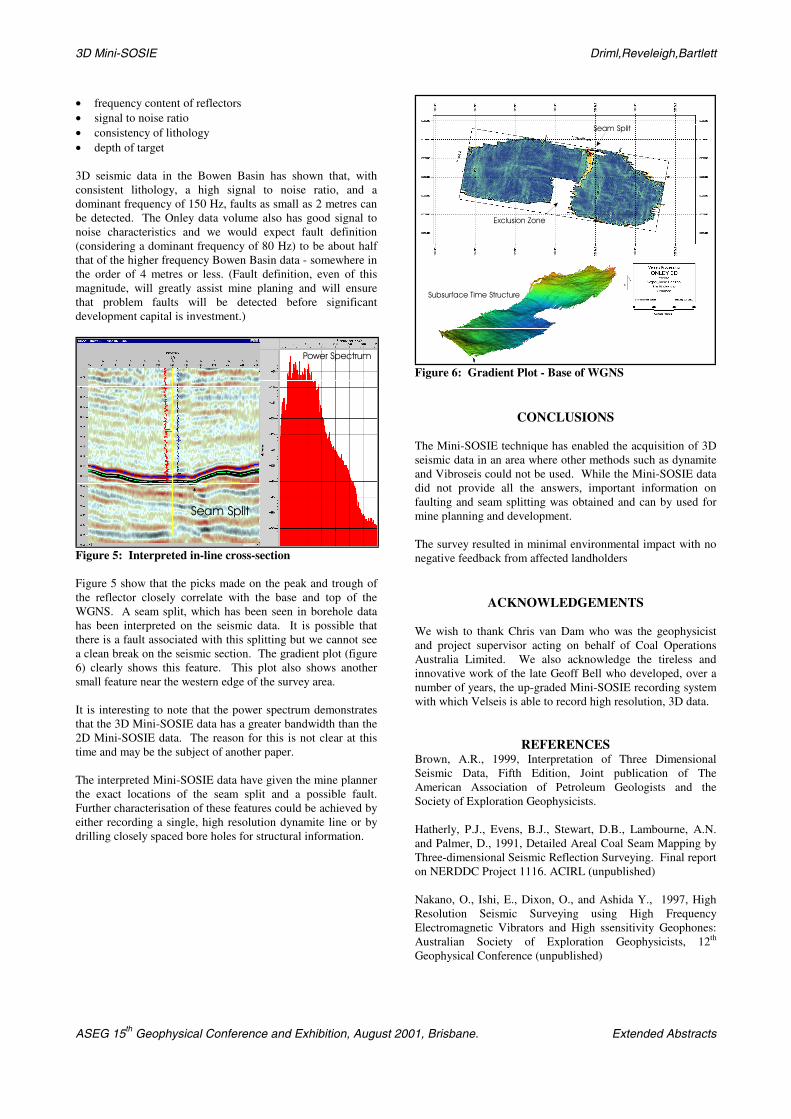
Seam Split
Power Spectrum
Figure 5: Interpreted in-line cross-section
Figure 5 show that the picks made on the peak and trough ofthe reflector closely correlate with the base and top of theWGNS. A seam split, which has been seen in borehole datahas been interpreted on the seismic data. It is possible thatthere is a fault associated with this splitting but we cannot seea clean break on the seismic section. The gradient plot (figure6) clearly shows this feature. This plot also shows anothersmall feature near the western edge of the survey area.
It is interesting to note that the power spectrum demonstratesthat the 3D Mini-SOSIE data has a greater bandwidth than the2D Mini-SOSIE data. The reason for this is not clear at thistime and may be the subject of another paper.
The interpreted Mini-SOSIE data have given the mine plannerthe exact locations of the seam split and a possible fault.Further characterisation of these features could be achieved byeither recording a single, high resolution dynamite line or bydrilling closely spaced bore holes for structural information.
Seam Split
Exclusion Zone
Subsurface Time Structure
Figure 6: Gradient Plot - Base of WGNS
CONCLUSIONS
The Mini-SOSIE technique has enabled the acquisition of 3Dseismic data in an area where other methods such as dynamiteand Vibroseis could not be used. While the Mini-SOSIE datadid not provide all the answers, important information onfaulting and seam splitting was obtained and can by used formine planning and development.
The survey resulted in minimal environmental impact with nonegative feedback from affected landholders
ACKNOWLEDGEMENTS
We wish to thank Chris van Dam who was the geophysicistand project supervisor acting on behalf of Coal OperationsAustralia Limited. We also acknowledge the tireless andinnovative work of the late Geoff Bell who developed, over anumber of years, the up-graded Mini-SOSIE recording systemwith which Velseis is able to record high resolution, 3D data.
REFERENCESBrown, A.R., 1999, Interpretation of Three DimensionalSeismic Data, Fifth Edition, Joint publication of TheAmerican Association of Petroleum Geologists and theSociety of Exploration Geophysicists.
Hatherly, P.J., Evens, B.J., Stewart, D.B., Lambourne, A.N.and Palmer, D., 1991, Detailed Areal Coal Seam Mapping byThree-dimensional Seismic Reflection Surveying. Final reporton NERDDC Project 1116. ACIRL (unpublished)
Nakano, O., Ishi, E., Dixon, O., and Ashida Y., 1997, HighResolution Seismic Surveying using High FrequencyElectromagnetic Vibrators and High ssensitivity Geophones:Australian Society of Exploration Geophysicists, 12th
Geophysical Conference (unpublished)