Mineral Resources of Eight Wilderness Study Areas ... · through Zion National Park, all of which...
38
Mineral Resources of Eight Wilderness Study Areas Bordering Zion National Park, Washington and Kane Counties, Utah U.S. GEOLOGICAL SURVEY BULLETIN 1746-E
Transcript of Mineral Resources of Eight Wilderness Study Areas ... · through Zion National Park, all of which...

Mineral Resources of Eight Wilderness Study Areas Bordering Zion National Park, Washington and Kane Counties, Utah
U.S. GEOLOGICAL SURVEY BULLETIN 1746-E


Chapter E
Mineral Resources of Eight Wilderness Study Areas Bordering Zion National Park, Washington and Kane Counties, Utah
By R.E. VAN LOENEN, E.G. SABLE,H.R. BLANK, JR., H.N. BARTON, and P.M. BRIGGSU.S. Geological Survey
J.E. ZELTENU.S. Bureau of Mines
K.L COOK University of Utah
The wilderness study areas are Orderville Canyon, North Fork Virgin River, Deep Creek, Goose Creek Canyon, Beartrap Canyon, LaVerkin Creek Canyon, Taylor Creek Canyon, and Red Butte
U.S. CEO LOGICAL SURVEY BULLETIN 1746
MINERAL RESOURCES OF WILDERNESS STUDY AREAS SOUTHWESTERN UTAH

DEPARTMENT OF THE INTERIOR
DONALD PAUL MODEL, Secretary
U. S. GEOLOGICAL SURVEY
Dallas L Peck, Director
Any use of trade names in this report is for descriptive purposes only and does not imply endorsement by the U.S. Geological Survey or the U.S. Bureau of Mines.
UNITED STATES GOVERNMENT PRINTING OFFICE: 1989
For sale by theBooks and Open-File Reports SectionU.S. Geological SurveyFederal CenterBox 25425Denver, CO 80225
Library of Congress Cataloging-in-Publication Data
Mineral resources of eight wilderness study areas bordering Zion National Park, Washington and Kane Counties, Utah.
(Mineral resources of wilderness study areas southwestern Utah ; ch. E) (U.S. Geological Survey bulletin ; 1746-E)
Bibliography: p. Supt. of Docs, no.: I 19.3:1746-E1. Mines and mineral resources Utah Zion National Park Region.2. Wilderness areas Utah Zion National Park Region. I. Van Loenen,
Richard E. II. Series. III. Series: U.S. Geological Survey bulletin ; 1746-E. QE75.B9 no. 1746-E 557.3 s [553'.09792'48] 88-600386 [TN24.U8]

STUDIES RELATED TO WILDERNESS
Bureau of Land Management Wilderness Study Areas
The Federal Land Policy and Management Act (Public Law 94-579, October 21, 1976) requires the U.S. Geological Survey and the U.S. Bureau of Mines to conduct mineral surveys on certain areas to determine the mineral values, if any, that may be present. Results must be made available to the public and be submitted to the President and the Congress. This report presents the results of a mineral survey of the Orderville Canyon (UT-040-145), North Fork Virgin River (UT-040-150), Deep Creek (UT-040-146), Goose Creek Canyon (UT-040-176), Beartrap Canyon (UT-040-177), LaVerkin Creek Canyon (UT-040-153), Taylor Creek Canyon (UT-040-154), and Red Butte (UT-040-147) Wilderness Study Areas, Washington and Kane Counties, Utah.


CONTENTS
Abstract El Summary El
Character and setting El Identified resources E5 Potential for undiscovered resources E6
Introduction E6Investigations by the U.S. Bureau of Mines E8 Investigations by the U.S. Geological Survey E9
Appraisal of identified resources E9Mining and mineral exploration history E9 Mines and prospects, and mining claims and leases E9 Appraisal of sites examined E10
Gypsum E10Construction and industrial sandstone, sand, and gravel Ell Ornamental sand and sandstone Ell Limestone Ell Coal EllIron concretions Ell
Assessment of potential for undiscovered resources E12 Geology E12
Geologic setting E12 Description of rock units E12
Subsurface rocks E12 Surface rocks E13
Jurassic rocks E13 Cretaceous rocks E14 Quaternary deposits E14
Structure E15 Geophysics E15
Gravity data E15 Aeromagnetic data E15 Aeroradiometric data E18
Geochemistry E18 Methods E18 Results E19
Mineral and energy resources E19 Oil and gas E19
Potential E20 Metals E20
Silver E20 Uranium E20
Geothermal sources E21 Coal E21
Potential E22 Gypsum E22
References cited E22 Appendix E25
Contents

PLATE
[Plate is in pocket]
1. Maps showing identified resources, mineral and energy resource potential, and geology of the eight wilderness study areas, Washington and Kane Counties, Utah
FIGURES
1-5. Maps of the eight wilderness study areas showing:1. Identified resources and resource potential E22. Location E43. Physiographic setting E54. Bouguer gravity contours E165. Aeromagnetic contours E17
TABLE
1. Summary of identified resources and resource potential for eight wilderness study areas bordering Zion National Park, Utah E3
VI Contents

MINERAL RESOURCES OF WILDERNESS STUDY AREAS-SOUTHWESTERN UTAH
Mineral Resources of Eight Wilderness Study Areas Bordering Zion National Park, Washington and Kane Counties, Utah
By R.E. Van Loenen, E.G. Sable, H.R. Blank, Jr., H.N. Barton, and P.M. Briggs U.S. Geological Survey
J.E. ZeltenU.S. Bureau of Mines
K.L Cook University of Utah
ABSTRACT
In 1986-87, the USGS (U.S. Geological Survey) and the USBM (U.S. Bureau of Mines) conducted a mineral resource appraisal of eight wilderness study areas bordering Zion National Park, Washington and Kane Counties, Utah. They are Orderville Canyon (UT-040-145), North Fork Virgin River (UT-040-150), Deep Creek (UT-040-146), Goose Creek Canyon (UT-040-176), Beartrap Canyon (UT-040-177), LaVerkin Creek Canyon (UT-040-153), Taylor Creek Canyon (UT-040-154), and Red Butte (UT-040-147). The study areas range in size from 35 to 3,320 acres. The identified resources and mineral and energy resource potential of the study areas are summarized on figure 1 and in table 1. Inferred subeconomic resources of gypsum are present in the Orderville Canyon, North Fork Virgin River, and Deep Creek study areas; inferred subeconomic resources of common-variety sandstone occur in all of the study areas; and inferred subeconomic resources of limestone occur in all but the Red Butte study area. All of the study areas have the following mineral and energy resource potential for these undiscovered resources: moderate potential for oil and gas, and low potential for all metals (including silver and uranium)
Manuscript approved for publication, August 10, 1988.
and geothermal sources. The Orderville Canyon, North Fork Virgin River, and Deep Creek study areas have a low energy resource potential for undiscovered coal; the other five study areas have no potential for undiscovered coal. Although the Orderville Canyon, North Fork Virgin River, and Deep Creek study areas have subeconomic resources of gypsum, they have no mineral resource potential for additional undis covered gypsum; the other five study areas also have no potential for undiscovered gypsum.
SUMMARY
Character and Setting
The eight study areas are about 15-25 mi (miles) south of Cedar City in Washington and Kane Counties, Utah (fig. 2). Seven of the study areas are along a 15-mi segment of the northeastern boundary of Zion National Park, and the other study area lies along the southwestern boundary. The study areas are (counterclockwise around the northern half of the park) Orderville Canyon (1,750 acres), North Fork Virgin River (1,040 acres,, Deep Creek (3,320 acres), Goose Creek Canyon (89 acres), Beartrap Canyon (40 acres), LaVerkin Creek Canyon (440 acres), Taylor Creek Canyon (35 acres), and Red Butte (804 acres). The study areas, for the most part, are relatively small tracts of land administered by the BLM (U.S. Bureau of Land Management) and surrounded by
Eight Wilderness Study Areas Bordering Zion National Park E1

113 37° 30'
'12' 1 1 2°50'
TAYLOR
CREEK CANYON
(UT-040-1 54)1
37' 17'
IRON COUNTY | WASHINGTON COUNTY
LAVERKIN CREEKCANYON(UT-040-153)
Kolob Reservoir
M/CBEARTRAP CANYON
(UT-040-177)
Blue Springs Reservoir
NORTH FORK VIRGIN RIVER
(UT-040-1 50)
GOOSE CREEK^^ -T-| CANYON * {
(UT-040-176) M/C
Zion
National
Park
5 MILES
ORDERVILLE CANYON (UT-040-145}
EXPLANATION OF IDENTIFIED RESOURCES AND MINERAL AND ENERGY RESOURCE POTENTIAL[See table 1 for summary of identified resources and resource potential for each of the eight study areas. All eight study areas have a low mineral and energy resource potential for all metals (including silver and uranium) and geothermal sources, with cer tainty level D. The Orderville Canyon, North Fork Virgin River, and Deep Creek study areas have a low energy resource poten tial for coal, with certainty level D; the other five study areas have no potential for coal, with certainty level D. Although the Orderville Canyon, North Fork Virgin River, and Deep Creek study areas have identified resources of gypsum, they have no mineral resource potential for additional gypsum, with certainty level D; the other five study areas have no potential for gypsum, with certainty level D]
Area of identified resources of gypsum
Geologic terrane having a moderate energy resource potential for oil and gas, with certainty level C Applies to entirety of all eight study areas
Approximate boundary of wilderness study area
D
Certainty levels
Data indicate geologic environment and suggest level of resource potential
Data indicate geologic environment and resource potential but do not establish activity of resource-forming processes
Data clearly define geologic environment and level of resource potential, and indi cate activity of resource-forming pro cesses in all or part of study area
Figure 1. Identified resources and mineral and energy resource potential of the eight wilderness study areas, Washington and Kane Counties, Utah.
private, State, and National Park Service-administered land. The boundaries of the study areas are essentially all legal land nets; some were modified slightly to accommodate existing roads and topography.
Except for the Red Butte study area, the eight study areas are remarkably similar in geology and physiographic setting. The Red Butte study area consists of a prominent sandstone butte. Each of the other seven represents a part of
E2 Mineral Resources of Wilderness Study Areas Southwestern Utah

Table 1 . Summary of identified resources and resource potential for eight wilderness study areas bordering Zion National Park, Utah
Wilderness study area Acres Identified resources Resource potential
Orderville Canyon (UT-040-145).
1,750
North Fork Virgin River 1,040 (UT-040-150).
Deep Creek 3,320 (UT-040-146).
Goose Creek Canyon 89 (UT-040-176).
Beartrap Canyon 40 (UT-040-177).
LaVerkin Creek Canyon 440 (UT-040-153).
Taylor Creek Canyon 35 (UT-040-154).
Red Butte 804 (UT-040-147).
Inferred subeconomic resources of gypsum (about 20 million tons), sandstone, and limestone.
Inferred subeconomic resources of gypsum (about 20 million tons), sandstone, and limestone.
Inferred subeconomic resources of gypsum, sandstone, and limestone.
Inferred subeconomic resources of sandstone and limestone.
Inferred subeconomic resources of sandstone and limestone.
Inferred subeconomic resources of sandstone and limestone.
Inferred subeconomic resources of sandstone and limestone.
Inferred subeconomic resources of sandstone.
Moderate resource potential for oil and gas. Low resource potential for metals, geothermal
sources, and coal. No resource potential for additional gypsum.
Moderate resource potential for oil and gas. Low resource potential for metals, geothermal
sources, and coal. No resource potential for additional gypsum.
Moderate resource potential for oil and gas. Low resource potential for metals, geothermal
sources, and coal. No resource potential for additional gypsum.
Moderate resource potential for oil and gas. Low resource potential for metals and
geothermal sources. No resource potential for coal and gypsum.
Moderate resource potential for oil and gas. Low resource potential for metals and
geothermal sources. No resource potential for coal and gypsum.
Moderate resource potential for oil and gas. Low resource potential for metals and
geothermal sources. No resource potential for coal and gypsum.
Moderate resource potential for oil and gas. Low resource potential for metals and
geothermal sources. No resource potential for coal and gypsum.
Moderate resource potential for oil and gas. Low resource potential for metals and
geothermal sources. No resource potential for coal and gypsum.
a major canyon near the headwaters of drainages that flow through Zion National Park, all of which are part of the Virgin River system.
The study areas are located on the Kolob Terrace along the southwest margin of the Colorado Plateau physiographic province (fig. 3). The Kolob Terrace is a "step" in the "Grand Staircase," a name applied to this region because the skyline resembles a staircase. The landform is marked by major topographic terraces that descend nearly 6,0X30 ft (feet) from northeast to southwest into Arizona. The Kolob Terrace extends for about 30 mi between Cedar City and Orderville. The Kolob Terrace is bordered by the Hurricane fault zone to the west and by the Sevier fault zone to the east. The study areas are between 5,000 and 7,800 ft in elevation. Terrain within and surrounding the study areas is quite rugged; some of the canyons are over 1,000 ft deep, and Red Butte rises nearly 800 ft above a lower terrace of the Kolob Plateau.
Sedimentary rock of Jurassic and Cretaceous ages (see geologic time chart in Appendix) is exposed in that part of the Kolob Terrace containing the study areas (pi. 1). These exposed rock units include the Kayenta Formation, Navajo Sandstone, Temple Cap Sandstone, Carmel Formation,
Dakota Formation, Tropic Shale, and Straight Cliffs Sandstone. The Navajo is the major rock unit in all the study areas, the Kayenta is exposed only at Red Butte, and the Dakota and Tropic units occur in the Orderville Canyon, North Fork Virgin River, and Deep Creek study areas. Basalt flows of Quaternary age cover parts of the Deep Creek study area.
The Navajo and Temple Cap, for the most part, form the canyon walls, and the limestone member of the Carmel occupies timber-covered flats or benches above the canyons. The banded and gypsiferous members of the Carmel, the Winsor Member of the Carmel, and the Dakota and the Tropic, in general, underlie mostly brush-covered slopes above the flats. The Kayenta forms the lower part of Red Butte and the Straight Cliffs is a ledge former above the Tropic.
The seven study areas along the northeastern part of the park can be reached by traveling north on an unpaved road that leaves State Highway 9 just east of the park (fig. 2). The Orderville Canyon study area is about 8 mi north on this road, and about 5 mi farther the road crosses the North Fork of the Virgin River. A popular hiking trail begins there and
Eight Wilderness Study Areas Bordering Zion National Park E3

112°38'
. ... DEEP CREEK Kolob ^.
37°05'
Figure 2. Location of the eight wilderness study areas (shaded) bordering Zion National Park, Washington and Kane Counties, Utah. Four nearby wilderness study areas are also shown (Canaan Mountain, Parunuweap Canyon, Spring Creek Canyon, and The Watchman). Wilderness study area boundaries are approximate. Dashed lines indicate unpaved roads. Note: (1) The formal names of two creeks are as follows: Bear Trap Creek, La Verkin Creek. (2) The following topographic features are not formally named: canyon of Goose Creek, canyon of La Verkin Creek, canyon of Taylor Creek.
follows the river through the North Fork Virgin River study area and through Zion National Park. The east side of the Deep Creek study area and the northern part of the North Fork Virgin River study area are served by a jeep trail leading west where the main road crosses the North Fork of the Virgin River. Several jeep trails and secondary roads lead both east and west in the vicinity of Kolob Reservoir to the western parts of the Deep Creek, Goose Creek Canyon, and Beartrap Canyon study areas, and to the eastern part of the
LaVerkin Creek Canyon study area. Access to the Taylor Creek Canyon study area and the western parts of the LaVerkin Creek Canyon study area is provided from the north by a gravel road starting near Kanarraville, Utah, and ending near the study areas.
The Red Butte study area is easily accessible from the paved road that begins at Virgin, Utah, and continues north through the Kolob (northwestern) part of Zion National Park.
E4 Mineral Resources of Wilderness Study Areas Southwestern Utah

112°35'
37°00'
Figure 3. Physiographic setting of the eight wilderness study areas and vicinity, Utah. See figure 2 for locations of the eight study areas.
Identified Resources
An extensive gypsum bed in the Jurassic Carmel Formation (gypsiferous member) occurs in the Orderville Canyon, North Fork Virgin River, and Deep Creek study
areas. Inferred subeconomic resources of at least 20 million tons of surface-minable gypsum occur in both the Orderville Canyon and North Fork Virgin River study areas (fig. 1); resources of gypsum were not calculated for the Deep Creek study area because of poor exposures.
Eight Wilderness Study Areas Bordering Zion National Park E5

Inferred subeconomic resources of common-variety sandstone occur in all of the study areas, and inferred subeconomic resources of limestone occur in all of the study areas except for Red Butte. Because these commodities have a low unit value and ample supplies of similar materials are available elsewhere in the region closer to transportation centers and markets, it is doubtful that these deposits will be developed in the foreseeable future.
Formations that host uranium deposits elsewhere on the Colorado Plateau have no evidence of near-surface uranium-mineralized rock in the study areas.
Coal was mined to the north and east of the study areas, but coal-bearing formations have not been tested in the study areas. There has been no exploration by drilling for oil and gas in the study areas.
Potential for Undiscovered Resources
The formations exposed in the study areas are not known to contain major ore deposits or energy sources anywhere in the region, and geologic mapping and geo- chemical sampling did not reveal any anomalous mineral concentrations. Geophysical data did not indicate any anomalies in the study areas.
The eight wilderness study areas have a moderate energy resource potential for oil and gas. The stratigraphic setting of the study areas is similar to that of the nearby Virgin oil field, located about 2 mi northeast of Virgin, Utah. Since 1907, the Virgin field has produced about 200,000 barrels of oil from structural and stratigraphic traps in the Timpoweap Member of the Triassic Moenkopi Formation and probably from the Permian Kaibab Limestone. These and other favorable Paleozoic reservoir rocks occur more than 2,500 ft beneath the study areas.
The study areas have a low mineral resource potential for undiscovered resources of all metals, including silver and uranium. The Moenave and Chinle Formations, which respec tively contain silver and uranium elsewhere in the region, are present beneath the study areas but at depths ranging from 500 to over 2,000 ft. The paucity of mineral deposits in these units in southwestern Utah and their depth beneath the study areas suggest a low potential for the discovery of metals within the study areas.
The study areas lie in terrane defined as having low terrestrial heat flow (Muffler, 1978) and therefore have a low energy resource potential for geothermal sources.
Although the study areas are partly within the Kolob coal field, the important coal-bearing beds of the Cretaceous Tropic Shale are not present. The Orderville Canyon, North Fork Virgin River, and Deep Creek study areas have a low energy resource potential for coal in the lower parts of the Tropic; the other five study areas do not contain Cretaceous rocks and therefore have no potential for coal.
The gypsiferous member of the Carmel Formation is present at the surface in and near the Orderville Canyon, North Fork Virgin River, and Deep Creek study areas and is also present in the subsurface adjacent to these study areas. These three study areas have inferred subeconomic resources of gypsum, and no mineral resource potential for
additional gypsum. The gypsiferous member is not present in any of the other five study areas, and they have no potential for gypsum.
INTRODUCTION
The eight wilderness study areas border Zion National Park in Washington and Kane Counties in the canyonlands of southwest Utah (fig. 2). The study areas are, counterclockwise around the northern one-half of the park, Orderville Canyon (UT-040-145), North Fork Virgin River (UT-040-150), Deep Creek (UT-040-146), Goose Creek Canyon (UT-040-176), Beartrap Canyon (UT-040-177), LaVerkin Creek Canyon (UT-040-153), Taylor Creek Canyon (UT-040-154), and Red Butte (UT-040-147). Due to their relatively small sizes and similar geologic settings and resource potentials, the eight wilderness study areas are combined in this report, and unless reference is made to a specific study area (or areas), all eight are here referred to as the study areas. In addition to these study areas, four other study areas border Zion National Park (fig. 2). The mineral resources of the Canaan Mountain (UT-040-143), The Watchman (UT-040-149), and the Parunuweap Canyon (UT-040-230) study areas have been reported on by Van Loenen and others (1988a, b), and work on the Spring Creek Canyon (UT-040-148) study area is in progress.
The boundaries of the eight study areas are essentially all elements of legal land nets defining tracts of BLM-administered land surrounded by State, private, and National Park Service-administered land. Land net boundaries of the Deep Creek and Goose Creek Canyon study areas were slightly modified to exclude land containing existing roadways, and the Orderville Canyon boundary is defined in part by topography.
The salient features within all the study areas, except Red Butte, are deep canyons, remarkably similar in geology and physiography, near the headwaters of the major Virgin River tributaries that flow through Zion National Park. Rocks exposed in the study areas are sedimentary rocks of the Jurassic Kayenta Formation, Navajo Sandstone, Temple Cap Sandstone, and Carmel Formation, and the Cretaceous Dakota Formation and Tropic Shale. Quaternary basalt flows cover parts of the Deep Creek study area. The Navajo and Temple Cap, for the most part, form the canyon walls, and limestone of the Carmel occupies timber-covered flats or benches above the canyons. The banded and gypsiferous members of the Carmel, the Winsor Member of the Carmel, and the Dakota and the Tropic in general form steeper brush-covered slopes above the flats. Red Butte is an erosional remnant of Navajo and Kayenta rocks that support little vegetation.
E6 Mineral Resources of Wilderness Study Areas Southwestern Utah

The study areas are located near the southwest margin of the Colorado Plateau physiographic province. This region of southwest Utah and northern Arizona is often referred to as the "Grand Staircase." Landforms here consist of terraces or "steps" that descend nearly 6,000 ft from the high plateaus of southern Utah southwest into Arizona. The terraces represent erosional levels in a thick section of heterogeneous rock. This erosion began in Cenozoic time and continues in the present at a relatively rapid pace. The study areas are on the Kolob Terrace, a "step" in the staircase at about 7,000-ft elevation. The Kolob Terrace is terminated on the west by the Hurricane fault zone and on the east by the Sevier fault zone (fig. 3).
There has been no mining or evidence of prospecting in any of the study areas. Stock grazing and limited logging activities were carried out in some parts of the study areas in the past, but little activity was evident at the time of this study. Except for the Red Butte study area, the study areas are located in remote areas and access to them is difficult.
The Orderville Canyon Wilderness Study Area contains 1,750 acres along the east boundary of Zion National Park in Washington County, Utah. Major topographic features include parts of Orderville Canyon, Esplin Gulch, and Birch Hollow. Elevations range from 5,200 ft in Orderville Canyon at the park boundary to 6,600 ft in the southeast. The study area is about 8 mi north of State Highway 9 near a county road. A jeep trail leading to the west off the county road south of Birch Hollow provides access to the southern part of the study area. This trail ends near the site of an old sawmill where Ponderosa pine was timbered in the past. Jeep trails serve parts of the area north of Orderville Canyon. All of the trails in the vicinity are suitable for vehicular use only under dry conditions. They are used mainly for livestock grazing operations and hunting. Hunting lodges are along the main county road just south of the study area, and an abandoned uranium mine is located about ¥2 mi east of the study area.
The North Fork Virgin River Wilderness Study Area contains 1,040 acres along the Kane County line about 2 mi north of the Orderville Canyon study area. It shares part of its western boundary with Zion National Park. The main topographic feature within the study area is a 1-mi stretch of canyon cut by the North Fork of the Virgin River, which dissects the southern quarter of the study area. The study area can be reached by continuing north on the county road beyond Orderville Canyon to the North Fork of the Virgin River and hiking down the river to the study area. A popular hiking trail follows the river through the study area into the park, through the North Fork "Narrows," and ending at the southern park entrance. A jeep trail heading west off the main road north of the river transects the northwestern part of the
study area. Topographic relief in the study area is about 1,500 ft, from the river bottom at the park boundary at about 5,400 ft to over 6,800 ft in brush-covered slopes along the northern boundary of the study area.
The Deep Creek Wilderness Study Area, the largest of the eight study areas, contains 3,320 acres in the northeastern part of Washington County. It is about V2 mi west of the North Fork Virgin River study area. Salient features of the study area include spectacular canyons cut by sections of Kolob Creek, Deep Creek, and the North Fork of the Virgin River. These three canyons merge about 1 mi south of the study area in Zion National Park. The canyon cut by Deep Creek is more than 1,000 ft deep at the park boundary; the elevation at the creek is 5,000 ft. The highest point in the study area is about 7,000 ft along the northeast border. Little activity was seen in and around the study area, but land above the canyons was used in the past for grazing and timbering and some land appears to have been cultivated. The study area extends 3 mi north of the park boundary to include an area of basalt flows, and a volcanic cinder cone lies just north of the border.
Access to the Deep Creek study area from the east is gained by continuing west beyond the North Fork Virgin River study area. This road follows along part of the Deep Creek study area's eastern boundary and ends at an abandoned sawmill site. Other roads in this area have been closed at the study area's boundary. Access is much easier from the west, but most of the roads there are on private land. The study area is from 6 to 10 mi east of Kolob Reservoir. Several roads heading east from the reservoir go as far as Deep Creek. There are no established hiking trails in the study area, and access into the canyons is difficult except at their uppermost parts.
The Goose Creek Canyon Wilderness Study Area contains 89 acres and is about 1 mi west of the Deep Creek study area in the northeastern part of Washington County. It is bounded on the west and south by Zion National Park. Goose Creek drains to the southeast and empties into the North Fork of the Virgin River about 4 mi into the park. Relief in the study area exceeds 1,000 ft; Goose Creek at the park boundary is at about 5,900-ft elevation. The study area is accessible from a main road that serves and continues past Lava Point Lookout in the park south of Kolob Reservoir. A right fork off this road ends within the study area; the main road continues along the northern boundary of the study area. The area of private land between Kolob Reservoir and Goose Creek Canyon study area is currently being developed as sites for summer homes.
The Beartrap Canyon Wilderness Study Area consists of 40 acres along the park boundary 6 mi northwest of the Goose Creek Canyon study area in Washington County. This study area is in very rugged terrain. Two deep canyons tributary to the canyon of
Eight Wilderness Study Areas Bordering Zion National Park E7

Bear Trap Creek join near the center of this small tract, and relief, which begins at 6,600-ft elevation in the creek bottom, is more than 1,000 ft at the study area boundary. There are no roads or trails nearby and entering the park from the study area is difficult. A road west from Blue Springs Reservoir ends about 2 mi south of the study area, and the road along the west side of Kolob Reservoir is no closer than 2 mi from the study area. The Beartrap Canyon study area is bounded on three sides by private land and on the west by the park.
The LaVerkin Creek Canyon Wilderness Study Area contains 440 acres in Washington County about 3 mi west of Kolob Reservoir and 2 mi northwest of the Beartrap Canyon study area. La Verkin Creek flows southwest through the study area across Zion National Park and empties into the Virgin River at La Verkin, Utah. Salient features in the study area include a 2-mi stretch of canyon cut by La Verkin Creek and part of Bear Canyon, a tributary to La Verkin Creek. Elevations range from about 5,800 ft in the creek bottom at the park boundary to 7,000 ft in the northwest corner. The study area is bounded by private land, except the southern boundary, which is shared with the park. The study area can be reached from the east by taking a jeep trail that heads west from the northwestern part of Kolob Reservoir and passes by Birch Spring. The La Verkin Creek hiking trail, which begins near Birch Spring, descends into Willis Creek and joins La Verkin Creek about 1 mi south of the study area in the park. Access to the west side of the study area is provided by taking a gravel road north of Kanarraville, Utah, to the east that climbs over the Hurricane Cliffs and heads south. Travel on this road is mainly through private land restricted by locked gates. Several trails leading off this road to the east end near the study area boundary. Stock grazing is currently active in and near the LaVerkin Creek Canyon study area.
The Taylor Creek Canyon Wilderness Study Area contains 35 acres at the head of the middle fork of Taylor Creek in northeast Washington County. This study area, the smallest of the study areas, is bounded on the west by Zion National Park, and is made up almost entirely of a 600-ft-deep steep-walled canyon. The upper rim of the canyon, at about 7,800-ft elevation, provides an excellent view of the canyon of Taylor Creek and a panoramic view of the park to the south. There is no access into the canyon from within the study area. The study area is located about 15 mi south of Cedar City, Utah, and about 2 mi west of the LaVerkin Creek Canyon study area. The Taylor Creek Canyon study area can be visited by taking the road from near Kanarraville, Utah, that serves the LaVerkin Creek Canyon study area. This road passes along the northeast corner of the Taylor Creek Canyon study area and ends at an abandoned cabin site southwest of the study area.
The Red Butte Wilderness Study Area contains 804 acres along the southwest side of Zion National Park. It is located in northeast Washington County about 12 mi north of Virgin, Utah. Red Butte is a prominent sand stone butte and a landmark in the region. It rises more than 1,000 ft above the lower Kolob Plateau and more than 2,000 ft above Smith Mesa. Smith Mesa, southwest of Red Butte, is the next "step" below Kolob Terrace. Red Butte can be visited by taking a gravel road leading to the west from the paved highway between Virgin, Utah, and the upper Kolob Plateau. Several roads serving Smith Mesa from near Virgin, Utah, pass close to the southwest base of Red Butte. Livestock grazing is active near the study area, and land at the base of Red Butte was cultivated in the past. Smith Mesa is a large, active agricultural area.
This report presents an evaluation of the mineral endowment (identified resources and mineral resource potential) of the study areas and is the product of several separate studies by the USBM and the USGS. Identified resources are classified according to the system of the USBM and USGS (1980), which is shown in the Appendix of this report. Identified resources are studied by the USBM. Mineral resource potential is the like lihood of the occurrence of undiscovered metals and nonmetals, industrial rocks and minerals, and of undis covered energy sources (coal, oil, gas, oil shale, and geothermal sources). It is classified according to the system of Goudarzi (1984) and is shown in the Appendix. The potential for undiscovered resources is studied by the USGS.
Investigations by the U.S. Bureau of Mines
The USBM's field investigation of the study areas was preceded by a review of various sources of information, including published and unpublished litera ture and USBM files, regarding the geology and mineral resources of the region. BLM files in Cedar City and Salt Lake City, Utah, were reviewed for mining claim and oil, gas, coal, and geothermal lease information. BLM geolo gists, National Park Service personnel at Zion National Park, and local residents were interviewed regarding minerals information in the region.
Field investigation, consisting of a search for mines, prospects, and mineralized areas in or within 1 mi of the study areas, was conducted in September 1986 and May 1987. A total of 32 rock samples was taken from outcrops and various workings. These samples were analyzed by Skyline Labs, Inc., Wheat Ridge, Colo. One panned-concentrate sample and one stream-sediment sample also were taken. These samples were analyzed by Chemex Labs, Inc., Sparks, Nev.
E8 Mineral Resources of Wilderness Study Areas Southwestern Utah

Six sandstone samples were taken and all were analyzed for gold, silver, and copper by atomic absorp tion spectrometry. Whole-rock analyses for major elements were performed on all six sandstone samples, and five were analyzed for 31 elements by optical emission spectrography. Selected samples were analyzed for uranium by fluorimetry and for vanadium by induc tively coupled plasma-atomic emission spectrography.
Whole-rock analyses were performed on six limestone and eight gypsum samples taken from out crops. All six limestone samples and three of the gypsum samples were analyzed for 31 elements by optical emission spectrography.
Twelve rock samples taken from uranium mines were analyzed for gold, silver, and copper by atomic absorption spectrometry, for uranium by fluorimetry, for vanadium by inductively coupled plasma-atomic emis sion spectrography, and for 31 elements by optical emission spectrography.
The panned-concentrate and stream-sediment samples were analyzed by fire assay for gold and by inductively coupled plasma-atomic emission spectro graphy for 32 elements.
Sample descriptions and analytical results are presented in Zelten (1987). Additional information is available from the USBM, Intermountain Field Opera tions Center, Building 20, Denver Federal Center, Den ver, CO 80225.
Investigations by the U.S. Geological Survey
The assessment of the potential for undiscovered resources in the eight study areas is based largely on the geologic setting, geophysical data, and geochemical data of the study areas, and on the production history of similar rock units in southwestern Utah. Field work for these studies was done in parts of June and September 1986, and June, September, and October 1987.
Geologic maps at 1:24,000 scale were compiled for the study areas using aerial photographs. Pertinent literature on the geology of the region includes a compre hensive report on the geology of the Zion National Park region (Gregory, 1950) and an overall geologic per spective with diagrammatic illustrations of geologic history and stratigraphic units of Utah (Hintze, 1973). Areal geologic reports and maps for various parts of the region have been prepared by Cashion (1967a), Sargent and Philpott (1985, 1987), and Hamilton (1978). Strati- graphic studies include a discussion of lower and middle Mesozoic units (Wilson and Stewart, 1967; Cashion, 1967b), and a review and interpretation of the Navajo Sandstone and other Jurassic units (Peterson and Pipiringos, 1979). A recent comprehensive report on the
geologic history and landforms of Zion National Park by Hamilton (1984) is oriented towards both professional and nonprofessional audiences.
Geophysical studies included gravity, aeromag- netic, and aeroradiometric surveys. Some new gravity stations were established, and data obtained from them were used in this report. Other gravity data were provided by K.L. Cook of the University of Utah. Aero- magnetic and aeroradiometric data for the region are available from the NURE (National Uranium Resource Evaluation) program and a published aeromagnetic map of the State of Utah (Zietz and others, 1976).
Stream-sediment samples were collected and ana lyzed in the geochemical survey. Analytical data and sample locations are by Bullock and others (in press).
Information used in assessing the potential for oil and gas resources is taken largely from Ryder (1983) and Molenaar and Sandberg (1983). Other sources of data are Bahr (1963), who described the Virgin oil field, Oakes and others (1981), who evaluated energy resources for the study areas, and the U.S. Department of Energy (1979), who evaluated uranium resources for the region. Data for the Kolob coal field are from Doelling and Graham (1972).
APPRAISAL OF IDENTIFIED RESOURCES
By J.E. ZeltenU.S. Bureau of Mines
Mining and Mineral Exploration History
No mines, prospects, or patented claims are in the study areas, nor are the study areas included in any mining district. The nearest mining district is the Silver Reef (Harrisburg) district, about 14 mi southwest of Red Butte. Between 1875 and 1910, over $8,000,000 of high- grade silver ore (over 7,000,000 oz (ounces) silver), with small amounts of associated copper, uranium, and vanadium, was produced from the Springdale Sandstone Member (formerly referred to informally as the Silver Reef sandstone) of the Moenave Formation in this district (Heyl, 1978; Proctor, 1953). In 1950, 8.68 tons of ore averaging 0.56 percent uranium was shipped (Gregory, 1950). The Moenave has not been tested in the study areas to determine if similar deposits are present.
Mines and Prospects, and Mining Claims and Leases
Unpatented lode claims and oil and gas leases and lease applications cover parts of several of the study areas. Two oil fields are within 8 mi of Red Butte.
Eight Wilderness Study Areas Bordering Zion National Park E9

A block of more than 300 unpatented lode claims just east of and slightly overlapping the southeastern boundary of the Orderville Canyon study area has been staked for uranium in the basal conglomerate unit of the Dakota. About Vi mi east of the Orderville Canyon study area several abandoned uranium mines and prospects on these claims were mapped and sampled (Zelten, 1987). The conglomerate unit is poorly cemented and consists of interbedded conglomerate, sandstone, and claystone; an underlying dark-gray shale unit was exposed in one adit. Silicified wood and carbonaceous or coaly streaks and lenses are common. Much of the conglomerate and sandstone are heavily stained by limonite. Gamma-ray spectrometer readings at the workings varied from about 250 to 13,300 cps (counts per second); background for the area was 150-250 cps. Carnotite and other uranium- oxide minerals are visible on outcrops and weathered surfaces. In 1950, 8.5 tons of ore, assaying 0.16 percent uranium trioxide (U3 O8 ), was shipped from the workings (Beroni and others, 1953). No uranium-vanadium resources were calculated at these workings because the metal concentrations were discontinuous. No evidence was found that similar deposits occur in the Orderville Canyon study area.
Eight unpatented lode claims, mostly within the northern part of the North Fork Virgin River study area, were apparently staked for gypsum in the Carmel Formation although there has been no exploration work.
A block of 70 unpatented lode claims partially overlaps the northwestern part of the Red Butte study area. These claims were staked for uranium and vana dium in the Moenave Formation, and currently (1987) are being prospected for uranium, vanadium, copper, and silver. A panned-concentrate sample and a stream- sediment sample were taken from near the northwestern study area boundary to determine if uranium, vanadium, copper, or silver were present; none was present in unusually high concentrations (Zelten, 1987).
Oil and gas leases and lease applications cover all of the Beartrap Canyon study area and most of the Red Butte study area. Oil and some gas have been produced from two fields in this part of Utah, the Virgin field and the Anderson Junction field, about 8 mi to the south and southwest, respectively, of Red Butte.
In the Virgin field, oil and small amounts of gas were produced intermittently from the Timpoweap (Sin- bad) Member of the Moenkopi Formation (Bahr, 1963; Irwin, 1976) and possibly the Kaibab Limestone. Total oil production from this field between 1907 and 1970 was over 200,000 barrels (Stowe, 1972). Several test holes drilled to various depths below the Moenkopi within 15 mi east of the Orderville Canyon study area and one hole drilled about 7 mi south of Red Butte were dry and abandoned. Approximately 1,380 barrels of oil were produced from the Pennsylvanian Callville Limestone in
the Anderson Junction field between 1968 and 1970. The field was shut in in 1971. Neither the Moenkopi nor the Callville have been tested in the study areas to determine if they contain oil or gas. (See Peterson, 1974).
Appraisal of Sites Examined
Inferred subeconomic resources in the study areas include gypsum, common-variety sandstone, and lime stone. Small, scattered accumulations of sand and gravel occur in several of the study areas. Coal was mined to the north and east of the study areas. Iron concretions, often sold in rock shops, weather out of the Navajo Sandstone in scattered locations throughout the region.
Gypsum
Inferred subeconomic resources of gypsum occur in the gypsiferous member of the Carmel Formation in the Orderville Canyon, North Fork Virgin River, and Deep Creek study areas. Averaging about 30-60 ft thick and dipping about 1° NE., this gypsum bed can be followed for many miles to the northwest and southeast.
Examination and sampling of the gypsum from this bed at various localities have shown its quality to be consistent (Zelten, 1987). The gypsum is sufficiently pure to have value for building materials, fertilizer, cement, and many other products. Gypsum is a low-unit-value, high-bulk commodity, and the single most important factor in evaluating a deposit is its proximity to markets. Deposits of high quality and commercial size are wide spread in the United States, and development largely depends on the accessibility and the demand for gypsum products in the region near the deposit. (See Appleyard, 1983; Bates, 1969; Moyer, 1939.) Because of the absence of a nearby market and the presence of large, minable deposits elsewhere in Utah nearer to markets, the gypsum in the study areas is not likely to be developed at this time or in the foreseeable future.
Gypsum in the Carmel crops out continuously for almost 2 mi in the vicinity of the southeastern part of the Orderville Canyon study area (pi. 1, map D). Inferred subeconomic resources of about 30 million tons of surface-minable gypsum occur in the study area and within Y* mi of its boundary. This estimate is based on an average thickness of 50 ft and an assumed continuity of gypsum back from the outcrop, and is limited to gypsum covered by no more than 100 ft of overburden. Of this tonnage at least 20 million tons lie within the study area. Any mining would be more likely to occur in the more flat-lying areas south and east of Orderville Canyon where larger quantities of gypsum are more accessible.
Gypsum in the Carmel crops out intermittently for about 2 mi along steep drainages in the vicinity of the northern part of the North Fork Virgin River study area
E10 Mineral Resources of Wilderness Study Areas Southwestern Utah

(pi. 1, map B). Inferred subeconomic resources of about 30 million tons of surface-minable gypsum occur in the study area and within 1A mi of its boundary. This estimate is based on an average thickness of 50 ft and an assumed continuity of gypsum back from the outcrop, and is limited to gypsum covered by no more than 100 ft of overburden. Of this tonnage at least 20 million tons lie within the study area. Any mining would be more likely to occur in the more flat-lying areas to the northeast and outside the study area where larger quantities of gypsum are more accessible.
Gypsum in the Carmel extends for about 2 mi across the northeastern part of the Deep Creek study area (pi. 1, map B). Inferred subeconomic resources of gypsum occur in the study area, but tonnages were not calculated because the unit is poorly exposed.
Construction and Industrial Sandstone, Sand, and Gravel
Inferred subeconomic resources of sandstone underlie all of the study areas and crop out over about 70 percent of their combined surface areas. Sand and small amounts of gravel are present on the uplands and in the drainages of the Orderville Canyon and Deep Creek study areas. These commodities could be used locally for construction purposes. Because these are high-volume, low-unit-value commodities and because transportation costs are a major factor in determining the value of a deposit, the remoteness and relative inaccessibility of these deposits make their development unlikely for other than local use. Some of the sandstone units could be used as bulk aggregate, but most of the rock is too friable for this purpose. Large deposits of material suitable for construction purposes and closer to transportation systems and markets are sufficient to supply present and projected future local use.
Industrial (silica) sand is used mostly in the glass- making, foundry, and abrasive industries. The sand should consist mainly of quartz grains and must be free of contaminants; rigid specifications of purity, silica content, and size must be met. (See Coope and Harben, 1977; Davis and Tepordei, 1985.) Whole-rock analyses of sandstone samples from the study areas indicate that the sand contains either too little silica or too much iron oxide to have industrial value (Zelten, 1987).
Ornamental Sand and Sandstone
Bleached or stained sand from the study areas could be used for sand painting and other decorative uses. The most desirable sand deposits are those that contain unusual as well as multiple colors in one locality, such as at one mine near Kanab, Utah. Sand in and near
the study areas is not of unusual color. Large deposits near Kanab are closer to current markets and are sufficient to supply anticipated present and future demands.
Picture rock is crossbedded sandstone that has been stained by iron oxide, resulting in interesting and unusual designs. The best known deposits are in the Navajo and the Chinle near Kanab. Picture rock is often cut into slabs that are sold as ornaments or wall hangings, or it may be ground into spheres or other decorative shapes. Iron stains and liesegang bands (secondary nested rings or bands caused by periodic or rhythmic precipitation of mostly iron oxides within a fluid- saturated rock) are common in the crossbedded Navajo Sandstone in the study areas, but no picture rock was observed and no such resources identified.
Limestone
An inferred subeconomic resource of limestone suitable for agricultural purposes exists in the Carmel Formation in all of the study areas except Red Butte. Crushed limestone also could be used locally for aggre gate, but sufficient quantities of similar material are available closer to markets. Because the Carmel possesses no unique characteristics that would make it more desirable than limestone present elsewhere in the region and closer to markets, development of this material is unlikely.
Coal
Coal has been mined from the Tropic Shale in the Kolob coal field, the southwestern limit of which has been mapped to within 1 mi of the Orderville Canyon, North Fork Virgin River, LaVerkin Creek Canyon, and Taylor Creek Canyon study areas (Cashion, 1961). Coal- bearing units may underlie landslide material in the northernmost parts of the North Fork Virgin River and Deep Creek study areas and the southeastern corner of the Orderville Canyon study area, but these areas have not been tested for coal. The coal-bearing units are not present in the other five study areas.
A 6-ft-thick carbonaceous shale unit of the Tropic is exposed in the northern part of the North Fork Virgin River study area in a road cut and in a drainage. Proximate and ultimate analyses of a sample of this shale, taken 2 ft in from the outcrop, showed it to be of poor quality with no commercial use (Zelten, 1987). It is not known if this carbonaceous shale grades laterally into coal in the subsurface. Coal resources were not identified in any of the three study areas mentioned previously and the Tropic is absent in the other five study areas.
Iron ConcretionsRounded to irregularly shaped iron concretions
commonly weather out of the Navajo Sandstone. Those
Eight Wilderness Study Areas Bordering Zion National Park E11

with unusual shapes, coloration, or internal construction are sometimes collected and sold as curiosities. Most of the popular collecting sites are east of Orderville Canyon. Concretions found in the Navajo in the study areas are typical of those that are abundant and readily available in much of the region.
ASSESSMENT OF POTENTIAL FOR UNDISCOVERED RESOURCES
By R.E. Van Loenen, E.G. Sable, H.R. Blank, Jr., H.N. Barton, and P.M. Briggs U.S. Geological Survey
K.L. Cook University of Utah
Geology
Geologic Setting
The study areas are on the Kolob Terrace in the western part of the Colorado Plateau physiographic province. This part of the province is characterized by gently dipping sedimentary rocks cropping out in deeply eroded plateaus and mesas. The Kolob Terrace trends northwest and extends for about 30 mi from Orderville to Cedar City, Utah (fig. 3). The terrace gives way to the higher Markagunt Plateau to the north; the terrace's eastern boundary is the Sevier fault zone and its western boundary is the Hurricane fault zone. The study areas are underlain by about 13,000 ft of Phanerozoic rock of which about 4,000 ft are exposed. Late Cenozoic uplift, and renewed activity along the Hurricane fault zone, accompanied and followed by deep erosion and volcan- ism (basalt flows and cinder cones) have produced the geologic setting of the present-day Kolob Terrace.
Description of Rock Units
Subsurface Rocks
Rocks in the subsurface of the study areas are of Paleozoic and early to middle Mesozoic ages and are more than 9,500 ft thick. Of the subsurface rocks, only the Springdale Sandstone Member of the Moenave Formation is also exposed at the surface. The following information pertaining to these rocks is extrapolated from reports on the Grand Canyon and Zion Park regions (Hintze, 1973) and the Canaan Mountain Wilderness Study Area (Van Loenen and others, 1988a),
and from oil and gas drill-hole records. The drill holes are at Pintura (10 mi northwest of Virgin, Utah (Gary, 1963)), about 7 mi north of Virgin (North Virgin Imperial #19-1 Federal), and near Mount Carmel Junction, Utah (Huston Oil and Minerals #41-11 Federal). Information on the latter two oil and gas wells was obtained from files of the Utah Geological and Mineralogical Survey.
Paleozoic rocks include, in ascending order: (1) more than 2,500 ft of Cambrian and Devonian strata including clastic rocks (shale, mudstone, siltstone, sand stone, and conglomerate), carbonate rocks (limestone and dolostone), and minor evaporite (gypsum and anhy drite), (2) the Mississippian Redwall Limestone (about 800-900 ft thick), (3) the Pennsylvanian Callville Lime stone (600-800 ft thick), and (4) the Permian Pakoon Limestone (750 ft thick), combined Queantoweap and Coconino Sandstones (1,350 ft thick), Toroweap Formation (550 ft thick), and Kaibab Limestone (about 260 ft thick). The latter two units contain evaporitic rocks. Of these formations, the Redwall, Pakoon, Quean toweap, Coconino, Toroweap, and Kaibab are con sidered to be potential oil and gas reservoirs.
Mesozoic rocks include the following strata. The Lower and Middle(?) Triassic Moenkopi Formation is about 1,800 ft thick and includes the following members, in ascending order: the Timpoweap, lower red, Virgin Limestone, middle red, Shnabkaib, and upper red. The Timpoweap consists of limestone and shale and is a potential oil and gas reservoir. The lower, middle, and upper red members are essentially reddish-brown siltstone and mudstone and contain minor gypsum; the Virgin Limestone Member consists mostly of fine grained impermeable gray limestone and interbedded pale-reddish-brown shale; and the Shnabkaib Member is largely reddish-brown siltstone and mudstone that contain beds, lenses, nodules, and stringers of noncommercial-grade gypsum. Overlying the Moenkopi, the Upper Triassic Chinle Formation is made up of the Shinarump Member (about 80-140 ft thick) and the overlying Petrified Forest Member (240-280 ft thick). The Shinarump is predominantly sandstone and con glomerate and minor shale, and the Petrified Forest Member is variegated claystone and shale containing volcanically derived clay and fluvial channel-fill sand stones. Both members contain uranium-bearing strata in many parts of the Colorado Plateau, although none of commercial tenor are known in the vicinity of the study areas. The top of the Chinle is estimated to be about 500-4,000 ft below the surface in the study areas. Overlying the Chinle, the Lower Jurassic(?) Moenave Formation is about 400 ft thick and consists of three members, in ascending order: the Dinosaur Canyon, Whitmore Point, and Springdale Sandstone Members. They consist of reddish-brown to gray siltstone, mud-
El 2 Mineral Resources of Wilderness Study Areas Southwestern Utah

stone, shale, and sandstone of fluvial and lacustrine origin. The Springdale Sandstone Member in the Silver Reef mining district at Leeds, Utah, was mined principally for silver in the late 19th century and for uranium in the early 1950's, but similar deposits are not known in the Springdale elsewhere.
Surface Rocks
About 4,000 ft of rocks are exposed at the surface in and near the study areas; they are Jurassic and Cretaceous sedimentary rocks and, locally, Quaternary lava flows. In the following sections, the rocks are described in ascending order.
Jurassic Rocks
The Lower Jurassic(?) Springdale Sandstone Member of the Moenave Formation (Jms) of the Glen Canyon Group is present only along the western edge of map C (pi. 1). This unit is a resistant cliff-forming pale- to light-red crossbedded sandstone that forms the surface for much of Smith Mesa. The Springdale is about 100 ft thick.
The Lower Jurassic(?) Kayenta Formation (Jk) is a reddish-brown siltstone, sandstone, and shale of fluvial and lacustrine origin, with some clay of probable volcanic derivation. This ledge-forming rock unit forms the lower part of Red Butte when viewed from the west on Smith Mesa. It is 700-800 ft thick in exposures in and adjacent to the Red Butte study area (map C, pi. 1); it is not exposed in the other seven study areas. No mineral or energy resources are known to occur in the Kayenta.
The Lower Jurassic(?) Navajo Sandstone (Jn) overlies the Kayenta and is exposed in all eight study areas (pi. 1). Although no complete sections of the Navajo are exposed in the study areas, it is as much as 2,200 ft thick in Zion National Park and 1,800-2,000 ft thick to the east in the Kanab 15-minute quadrangle (Sargent and Philpott, 1987). It forms spectacular, nearly vertical canyon walls in seven of the study areas, and it forms the upper part of the prominent butte in the Red Butte study area. The Navajo is characterized in all the study areas by pervasive sets of northwest- to northeast- trending joints. Weathering along these joints produced the jagged skyline on the summit of Red Butte. The Navajo is a homogeneous, loosely cemented, fine- to medium-grained, well-sorted sandstone exhibiting out standing examples of medium- to large-scale eolian crossbedding. It was deposited in an extensive desert "sand sea" that encroached southward from highlands north of the study areas about 180 million years ago. The Navajo is generally moderate reddish orange in its lower part and very light gray to nearly white in its upper part. The color differences are due mainly to the effects of
ground water on the cementing agents of lime, iron oxides, and clays. No mineral or energy resources are known in the Navajo although it is an excellent ground- water aquifer. Its great thickness, weathering properties, varied colors, crossbedding features, and fracture patterns combine to provide the most scenic charac teristics of any rock formation exposed in the region.
The Moenave, Kayenta, and Navajo have for many years been considered to be either Triassic or Triassic and Jurassic in age. Peterson and Pipiringos (1979), however, considered them to be provisionally Early Jurassic on the basis of palynomorphs in the Moenave. Their usage is used in this report.
The Middle Jurassic Temple Cap Sandstone (Jtc) consists of two members, the Sinawava and White Throne (Peterson and Pipiringos, 1979). The members were not mapped separately in this report. The Sinawava is a slope-forming unit of interbedded reddish-brown sandstone, siltstone, and mudstone. It is overlain by the White Throne, which is a cliff-forming, light-gray to tan, fine-grained, crossbedded sandstone of eolian origin. The Temple Cap thins from southeast to northwest across the Kolob Terrace, ranging in thickness from about 200 ft near the Deep Creek study area to only a few feet in the LaVerkin Creek Canyon study area (pi. 1). It appears to be absent in the Taylor Creek study area. The Temple Cap is not known to contain mineral or energy resources.
The Middle Jurassic Carmel Formation averages about 700 ft thick and consists of four separately mapped members, in ascending order: the limestone, banded, and gypsiferous members, and the Winsor Member. The limestone member is present in all of the study areas except Red Butte. The banded and gypsiferous members and the Winsor Member are present in the Orderville Canyon, North Fork Virgin River, and Deep Creek study areas; the banded member is also present in a small part of the LaVerkin Creek Canyon study area (pi. 1). Depositional environments of these strata ranged from shallow marine, perhaps in restricted embayments or lagoons, to marginal marine floodplains, to shallow evaporite-precipitating coastal plain environments. The only known exploited resources in the Carmel are limestone for road metal and alabaster (gypsum) for sculpture or ornamental objects.
The limestone member of the Carmel Formation (Jcl) ranges from 300 to 400 ft thick and consists of two informal units that are roughly equal in thickness. They are (1) a lower ledge-forming unit of thin- to medium- bedded, largely lithographic, tan-weathering limestone that grades upwards into a slope-forming unit of shaly limestone and interbedded pale-green and reddish- brown shale, and (2) an upper cliff-forming unit of relatively pure limestone much like that in the lower unit.
Eight Wilderness Study Areas Bordering Zion National Park E13

Marine fossils (pelecypods, gastropods, and crinoid remains) are locally common but generally sparse; minor oolitic limestone is most common in the upper unit.
The banded member (Jcb) is 120-160 ft thick and is generally poorly exposed and forms gentle to moderate slopes. Alternating beds of light-gray and reddish-brown, thin-bedded, friable sandstone and siltstone form a banded pattern where the member is well exposed.
The gypsiferous member (Jcg) is about 40 ft or less to 60 ft thick and consists of a lower ledge-forming unit of white to very light gray to pink gypsum and an upper slope-forming unit of gray and pale-green gypsif erous limestone, sandstone, and shale. The lower and upper contacts are not well defined, although a thin fossiliferous limestone bed at least locally marks the top of the member (Cashion, 1967b).
The Winsor Member (Jew) is about 180-200 ft thick and is generally very poorly exposed; it weathers to smooth, gentle slopes. It is largely a very fine grained friable moderate-red sandstone with thin interbeds of reddish-brown mudstone.
Cretaceous Rocks
Cretaceous rocks unconformably overlie the Carmel Formation. The unconformity represents a 60- million-year period of erosion and nondeposition that occurred throughout southwest Utah during the Sevier orogeny.
Upper Cretaceous rocks in and near the study areas are as much as 3,500 ft thick and consist of the Dakota Formation, Tropic Shale, and Straight Cliffs Sandstone. In this report, the Dakota and Tropic were mapped together as map unit Ktd.
The Dakota Formation in this general region is commonly made up of sandstone and conglomerate ranging from 0 to as much as 80 ft thick, which are locally replaced by a thin conglomerate having a shale matrix. Complete sections of the Dakota Formation and the Tropic Shale east of the study areas are about 900-1,400 ft thick (Cashion, 1967a). The Tropic there consists of two members. The lower member is about 200-600 ft thick and consists of carbonaceous shale, sandstone, and coal. This member is delimited by upper and lower coal zones. The upper member is about 500-1,200 ft thick and consists of mostly gray carbonaceous shale, minor shoreline-deposited sandstone, and thin coal beds. The Dakota and Tropic (Ktd) are present in a small area along the eastern part of the Orderville Canyon study area (map D, pi. 1), in the northern part of the North Fork Virgin River study area (map B, pi. 1), and in the northeastern part of the Deep Creek study area (map B, pi. 1). Anomalous amounts of uranium occur locally in conglomerate beds in the Dakota, and coal has been mined commercially in the region from the lower member of the Tropic.
The Straight Cliffs Sandstone (Ksc), about 120-600 ft thick, of which only the lower part is exposed (map B, pi. 1), intertongues with the Tropic Shale according to Cashion (1967a). The Straight Cliffs is a gray, planar-bedded sandstone, deposited mostly under marine shoreline conditions, interbedded with gray marine shale.
Quaternary Deposits
During Quaternary time, parts of the Kolob Terrace were covered with basalt flows (Qb) and cinder cones (Qc) produced during several volcanic events. The flows accumulated to several hundreds of feet in thickness and covered a topographic surface not unlike the present-day surface. The flows are fresh-appearing, homogeneous, black to gray, massive to vesicular olivine basalt. Cinder cones are common on the flows, and they may represent the final stages of volcanism for separate flow events. There are many cones, some more than 400 ft high, scattered as landmarks across the Kolob Terrace. Basalt flows and a 300-ft-high cinder cone occur to the southeast of the Red Butte study area. There are no volcanic rocks exposed in the Red Butte study area, but they may exist beneath eolian sand and silt cover in the southern part. Fjrtensive areas of Quaternary volcanic rocks are exposed 1 mi to the east of Red Butte in Zion National Park. At least three separate flows cover parts of the Deep Creek study area, with total accumulations of 140-400 ft. Basalt flows came from both the northwest and northeast and flowed into the upper parts of Deep Creek. The creek was probably dammed by the flows, but subsequent erosion has cleared the canyon. A cinder cone is situated on the flows about 1A mi north of the Deep Creek study area. Cinders from the more accessible cones in the region are used locally for road metal.
Basalt talus (Qbt), shown in areas of volcanic terrane near the Red Butte study area (map C, pi. 1) and in the Deep Creek study area (map B, pi. 1), represents an accumulation of large blocks of lava at the base of steep slopes. In part, the talus may represent fragmented flow edges produced during flow activity.
Eolian sand and silt (Qes) includes deposits of relatively small, currently active dunes and sheets and some older stabilized dunes. Sand and silt are light gray to yellowish gray, buff, and reddish orange, fine to medium grained, and composed mostly of quartz and very minor heavy minerals. The Navajo Sandstone is the chief source rock for this unit. These deposits occur where the Navajo is exposed on an upland surface in the Red Butte study area.
Landslide deposits (Qlsf), as mapped, include debris flow, slide, slump, and creep deposits of both bedrock and surficial materials. These deposits occur in
E14 Mineral Resources of Wilderness Study Areas Southwestern Utah

the Orderville Canyon, North Fork Virgin River, and Deep Creek study areas and consist mostly of disrupted shale and sandstone of the Tropic Shale. The Tropic, due to a high content of expanding clays, is prone to sliding. Initial movements of the slides may have been in early Quaternary time, but present small scarps indicate recent movement. Some smaller slides (not mapped) have occurred on the Kayenta Formation in the Red Butte study area.
Alluvium and colluvium (Qac) consist of (1) unconsolidated clay, sand, gravel, and silt as channel, floodplain, and lacustrine deposits, (2) local, alluvial-fan deposits and talus from rockfalls, and (3) relatively small landslide deposits and slump material (see pi. 1).
Structure
Although the Kolob Terrace lies between two major fault zones (Hurricane and Sevier), the terrace itself is relatively structureless. The sedimentary rocks dip slightly more than 1° NE., with mildly steeper dips occurring locally. Two major northerly trending faults (Beartrap and Wildcat Canyon) cut the Kolob Terrace, but they lie outside of the study areas. The Beartrap fault is about ¥1 mi to the northwest of the Beartrap Canyon study area. This fault is a northeast-trending normal fault that has as much as 800 ft of displacement. The fault can be traced for more than 5 mi from within Zion National Park to the northeast where it is concealed beneath landslide deposits. The northern extent of the Wildcat Canyon fault is about 2 mi west of the Goose Creek Canyon study area in the park. Faults having minor displacement occur in the Deep Creek, LaVerkin Creek Canyon, and Taylor Creek Canyon study areas. Numer ous northwest- to northeast-trending, nearly vertical fractures or joints are well expressed in the Navajo Sandstone. Displacement along these fractures is negli gible, and alteration or mineral deposits are not associated with them.
Geophysics
Gravity Data
The Bouguer gravity map (fig. 4) was compiled using data from 111 stations established by the USGS in 1986 and 1987 for BLM wilderness projects and from 95 stations established previously, the majority by the University of Utah (principal facts are available from the National Center for Geophysical and Solar-Terrestrial Data, Boulder, CO 80301). All gravity observations were reduced at a density of 2.67 g/cm3 (grams per cubic
centimeters) through standard USGS procedures (see, for example, Cordell and others, 1982).
The Bouguer gravity map (fig. 4) is dominated by a northeast-trending negative gradient whose average change in intensity is nearly 1 mGal (milligal) per kilometer. Three factors contribute to this gradient. First, the standard reduction density is significantly greater than the mean density of rocks above the topographic datum, which are predominantly clastic; therefore, the gradient must in part reflect the drastic increase in elevation from the Virgin River in the southwest to the Markagunt Plateau in the northeast. Use of a lower reduction density, for example 2.4 g/cm3 , ameliorates the regional gradient and virtually eliminates the sharp reentrant associated with Zion Canyon (stations on the canyon floor have relatively positive Bouguer values on fig. 4; the surrounding topography consists chiefly of Navajo Sandstone). Second, isostatic compensation of the topography may in part be affected by crustal thickening, which would produce more-negative Bouguer values in areas of higher altitude. Airy-type isostatic compensation could not, however, account for the steep gradient represented by the narrow belt of closely spaced contours running diagonally across the center of the map area from southeast to northwest. Also the regional gradient can still be found on an isostatic anomaly map of the Western United States based on an Airy model, although the gradient is reduced in amplitude. Third, it has been established from structural contour maps on sedimentary horizons that the elevation of the surface of the Precambrian crystalline basement falls off to the northeast. This deepening of the high- density basement is probably the chief factor contributing to the regional gravity gradient. The data suggest the existence of a Precambrian structural high centered to the southwest of the map area; a north-plunging anticli nal extension of this high is indicated by the Bouguer gravity high in the northwest corner of the map area, bounded on the west by a gradient associated with the Hurricane fault. The steepest part of the regional gradient may represent a "step" or local steepening of the basement surface not reflected by disturbance of the surface rocks. No apparent relation exists between this gravity structure and the distribution of volcanic centers or other features mapped in the region.
Aer©magnetic Data
The residual total-intensity aeromagnetic map (fig. 5) was prepared from data acquired for the NURE program. NURE traverses in the region were flown east-west at a nominal 400 ft above terrain and a 3-mi flight-line spacing. The Earth's main magnetic field has been removed from the data along with diurnal and other extraneous effects as part of the standard reduction procedure.
Eight Wilderness Study Areas Bordering Zion National Park E15

112°45'
5 ____I________
EXPLANATION
Gravity cdntour Contour interval 2 milligals.Hachures indicate closed low
Gravity station
From this study
Previously established
Fault or fracture Dashed where approx imately located or concealed (after Hintze, 1973)
10 MILES
Quaternary basalt (after Hintze, 1973)
Volcanic vent
"i Approximate boundary of wilderness study area For names, see figure 2
Boundary of Zion National Park
Figure 4. Complete Bouguer gravity anomaly contours of the eight wilderness study areas and vicinity, Utah.
E16 Mineral Resources of Wilderness Study Areas Southwestern Utah

11 3°00' 112°45'
10 MILES I
EXPLANATION
100 Aeromagnetic contour Contour interval 20 nanoteslas. Hachures indicate close low
Fault or fracture Dashed where approx imately located or concealed (after Hintze, 1973)
Quaternary basalt (after Hintze, 1973)
# Volcanic vent
^ Approximate boundary of wilderness studyarea For names, see figure 2
- Boundary of Zion National Park
Figure 5. Residual total-intensity aeromagnetic contours of the eight wilderness study areas and vicinity, Utah.
Eight Wilderness Study Areas Bordering Zion National Park E17
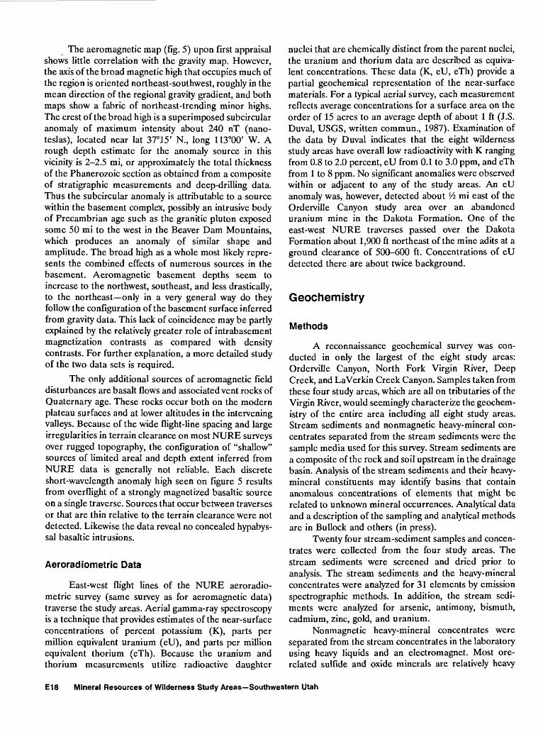
The aeromagnetic map (fig. 5) upon first appraisal shows little correlation with the gravity map. However, the axis of the broad magnetic high that occupies much of the region is oriented northeast-southwest, roughly in the mean direction of the regional gravity gradient, and both maps show a fabric of northeast-trending minor highs. The crest of the broad high is a superimposed subcircular anomaly of maximum intensity about 240 nT (nano- teslas), located near lat 37°15' N., long 113°00' W. A rough depth estimate for the anomaly source in this vicinity is 2-2.5 mi, or approximately the total thickness of the Phanerozoic section as obtained from a composite of stratigraphic measurements and deep-drilling data. Thus the subcircular anomaly is attributable to a source within the basement complex, possibly an intrusive body of Precambrian age such as the granitic pluton exposed some 50 mi to the west in the Beaver Dam Mountains, which produces an anomaly of similar shape and amplitude. The broad high as a whole most likely repre sents the combined effects of numerous sources in the basement. Aeromagnetic basement depths seem to increase to the northwest, southeast, and less drastically, to the northeast only in a very general way do they follow the configuration of the basement surface inferred from gravity data. This lack of coincidence may be partly explained by the relatively greater role of intrabasement magnetization contrasts as compared with density contrasts. For further explanation, a more detailed study of the two data sets is required.
The only additional sources of aeromagnetic field disturbances are basalt flows and associated vent rocks of Quaternary age. These rocks occur both on the modern plateau surfaces and at lower altitudes in the intervening valleys. Because of the wide flight-line spacing and large irregularities in terrain clearance on most NURE surveys over rugged topography, the configuration of "shallow" sources of limited area! and depth extent inferred from NURE data is generally not reliable. Each discrete short-wavelength anomaly high seen on figure 5 results from overflight of a strongly magnetized basaltic source on a single traverse. Sources that occur between traverses or that are thin relative to the terrain clearance were not detected. Likewise the data reveal no concealed hypabys- sal basaltic intrusions.
Aeroradiometric Data
East-west flight lines of the NURE aeroradio- metric survey (same survey as for aeromagnetic data) traverse the study areas. Aerial gamma-ray spectroscopy is a technique that provides estimates of the near-surface concentrations of percent potassium (K), parts per million equivalent uranium (eU), and parts per million equivalent thorium (eTh). Because the uranium and thorium measurements utilize radioactive daughter
nuclei that are chemically distinct from the parent nuclei, the uranium and thorium data are described as equiva lent concentrations. These data (K, eU, eTh) provide a partial geochemical representation of the near-surface materials. For a typical aerial survey, each measurement reflects average concentrations for a surface area on the order of 15 acres to an average depth of about 1 ft (J.S. Duval, USGS, written commun., 1987). Examination of the data by Duval indicates that the eight wilderness study areas have overall low radioactivity with K ranging from 0.8 to 2.0 percent, eU from 0.1 to 3.0 ppm, and eTh from 1 to 8 ppm. No significant anomalies were observed within or adjacent to any of the study areas. An eU anomaly was, however, detected about Vi mi east of the Orderville Canyon study area over an abandoned uranium mine in the Dakota Formation. One of the east-west NURE traverses passed over the Dakota Formation about 1,900 ft northeast of the mine adits at a ground clearance of 500-600 ft. Concentrations of eU detected there are about twice background.
Geochemistry
Methods
A reconnaissance geochemical survey was con ducted in only the largest of the eight study areas: Orderville Canyon, North Fork Virgin River, Deep Creek, and LaVerkin Creek Canyon. Samples taken from these four study areas, which are all on tributaries of the Virgin River, would seemingly characterize the geochem istry of the entire area including all eight study areas. Stream sediments and nonmagnetic heavy-mineral con centrates separated from the stream sediments were the sample media used for this survey. Stream sediments are a composite of the rock and soil upstream in the drainage basin. Analysis of the stream sediments and their heavy- mineral constituents may identify basins that contain anomalous concentrations of elements that might be related to unknown mineral occurrences. Analytical data and a description of the sampling and analytical methods are in Bullock and others (in press).
Twenty four stream-sediment samples and concen trates were collected from the four study areas. The stream sediments were screened and dried prior to analysis. The stream sediments and the heavy-mineral concentrates were analyzed for 31 elements by emission spectrographic methods. In addition, the stream sedi ments were analyzed for arsenic, antimony, bismuth, cadmium, zinc, gold, and uranium.
Nonmagnetic heavy-mineral concentrates were separated from the stream concentrates in the laboratory using heavy liquids and an electromagnet. Most ore- related sulfide and oxide minerals are relatively heavy
E18 Mineral Resources of Wilderness Study Areas Southwestern Utah

and nonmagnetic. The removal of most of the light weight rock-forming silicates, clays, organic material, and magnetic minerals permits the determination of some elements present in the concentrates that are not easily detectable in stream sediments.
Radioactivity was measured at selected outcrops of the Dakota and at all sampling sites.
Results
Threshold values (minimum concentrations con sidered anomalous for particular elements) in the bulk stream sediments and nonmagnetic heavy-mineral concentrates were determined by inspection of the analytical data. None of the stream sediments or concentrates collected from the four study areas had anomalous amounts of any of the analyzed elements, nor were any sampling sites or outcrops found to be radioactive.
Mineral and Energy Resources
There has been no mining within any of the eight study areas. Terrain underlain by Cretaceous rocks in the Orderville Canyon, North Fork Virgin River, and Deep Creek Canyon study areas was probably explored in the past for uranium deposits, such as those present nearby in Orderville Canyon, and for sources of coal. These three study areas are partly in the Kolob coal field. Other than industrial minerals (limestone and gypsum), the Jurassic rocks exposed in the eight study areas contain no known mineral or energy resources nor are they known to contain any in the region. Although southwest Utah is not known for oil and gas production, the study areas are relatively close to two abandoned oil fields. The following sections discuss the attributes of nearby localities where specific commodities have been produced and compare those attributes to the ones present within the study areas. The mineral resource potential is summarized in table 1.
Oil and Gas
Utah's oil and gas production comes primarily from three areas: the thrust belt of north-central Utah, the Paradox Basin of southeastern Utah, and the Uinta Basin of northeastern Utah. A few small fields that have produced or are currently producing oil and gas exist outside these three areas. The only producing field in southwestern Utah is the Upper Valley field located near Escalante, Utah, about 65 mi northeast of the study areas. The abandoned Anderson Junction and Virgin fields are about 8 mi southwest and south, respectively, of Red Butte.
Due to the proximity of the Virgin field and its similar geologic setting, the attributes of this field are used in the evaluation of oil and gas potential beneath the study areas. Oily tar that occurs in seeps in the vicinity of the Virgin field and several other localities nearby prompted exploration for oil and gas. The first well was drilled in the Virgin field in 1907. Since 1907, more than 150 wells have been drilled in and near the Virgin field, the latest being in 1986. Some of the wells produced as much as 30 BOPD (barrels of oil per day), but most wells yielded only 1-4 BOPD from shallow wells ranging from 500 to 800 ft deep. Total production from the Virgin field has been slightly more than 200,000 barrels of asphalt- paraffin base oil; most wells produced little or no gas.
The reservoir rocks in the Virgin field are lime- matrix conglomerates provisionally interpreted to be in the upper part of the Kaibab Limestone, and sandy limestones of the Timpoweap Member of the Moenkopi Formation. Oil in the Virgin field apparently accumu lated in a structural low on the nose of a broad, very gently plunging anticline. Differences in the physical properties of the oil from well to well may indicate separate stratigraphic traps within the structural low (Bahr, 1963). A structural high adjacent to and northeast of the Virgin field and 3 mi south of the Red Butte Wilderness Study Area was tested by drilling in 1986. This well bottomed in the Pennsylvanian Callville Limestone. Traces of dead oil were seen in some samples, and massive amounts of fresh water were encountered in limestones of the Timpoweap, Kaibab, and Toroweap. The well was considered dry and was abandoned (P. Carter, BLM, Cedar City, Utah, written commun., 1987).
Other structural highs in the region have been tested for oil, but none successfully. Four wells were drilled, one as recently as 1985, on a small anticline located south of the Virgin field. Commercial quantities of oil were not found in any of the wells.
The Colorado Plateau has had a favorable thermal history for the generation of oil and gas (Ryder, 1983), and some oil in this area may have been generated locally in Paleozoic and lower Mesozoic rock; however, there are no known source rocks rich in hydrocarbons. Such source rocks, for example, are the organic-rich shales of Pennsylvanian and Permian age from which oil is generated in the Paradox and Uinta Basins. The source of oil in this part of the Colorado Plateau in southwest Utah may be the abundant organic-rich Paleozoic rocks of the adjoining Basin and Range physiographic province in eastern Nevada and western Utah (Giardina, 1979). The most significant of these is the Mississippian Chain- man Shale, which provided oil to fields in east-central Nevada (Poole and Claypool, 1984). This source rock may have supplied hydrocarbons that subsequently underwent long-range migration across a structural
Eight Wilderness Study Areas Bordering Zion National Park E19

hingeline updip into southwestern Utah and north western Arizona. The hingeline is the boundary between the tectonically stable Colorado Plateau and the Basin and Range province.
Potential
The eight wilderness study areas have a moderate energy resource potential for oil and gas, with certainty level C, based on the structural and stratigraphic settings, proximity to the Virgin field, and results of exploration in the region. The surface geology is well known in the study areas, but there are no subsurface data. Exploration by drilling would be required to identify petroleum resources, and none has been done within the study areas. This assessment concurs with the rating given the study areas by Molenaar and Sandberg (1983).
Structural traps such as the mild upwarping of the sedimentary rocks in the Virgin field may be present beneath the study areas, although there are no known surface manifestations of significant structures. These subtle features, if present, would be difficult to locate in the study areas. The Virgin field structure trends north- northeast, and if this feature continued it could possibly affect strata beneath the Red Butte study area. Current oil and gas leases of part of the Red Butte and Beartrap Canyon study areas illustrate interest in this area. The possible reservoir rocks within the study area boundaries are buried beneath 2,500-6,000 ft of Triassic and Lower Jurassic rocks.
Stratigraphic traps resulting from facies changes in favorable rocks may form reservoirs for oil and gas beneath the study areas. Regionally, the study areas are updip from and on the eastern edge of the Paleozoic geosyncline where accumulations of sediments thin eastward from more than 20,000 ft in the deeper parts of the geosyncline to about 7,000 ft in this area. An environment such as this, wherein formations thin or wedge out on a continental shelf, is conducive to forming facies-change stratigraphic traps. Exploration in the region indicates that the most favorable reservoirs for oil and gas are in the Timpoweap Member of the Moenkopi Formation, Kaibab Limestone, Toroweap Formation, Queantoweap and Coconino Sandstones, and Pakoon, Callville, and Redwall Limestones. These formations are probably present at depth beneath the study areas.
The potential for oil and gas in the region is not high because the available reservoir rocks have been and still are susceptible to flushing by fresh water that was first introduced into the rocks in late Tertiary time after the region was uplifted and deeply dissected by erosion (Ryder, 1983). The presence of fresh water is not well documented in drilling records; however, it may be pervasive. The well drilled south of Red Butte in 1986, mentioned earlier in this report, contained massive
amounts of water in the Timpoweap, Kaibab, and Tor oweap, all potential reservoir rocks (P. Carter, BLM, Cedar City, Utah, written commun., 1987). Drilling records from a well drilled in the Anderson Junction field showed fresh water flowing in the Callville Limestone and Redwall Limestone (Giardina, 1979).
Metals
The eight wilderness study areas have a low mineral resource potential for all metals, including silver and uranium, with certainty level D. The bulk of the rock units exposed in the study areas (Navajo and Temple Cap Sandstones, and Carmel Formation) are not known to contain ore deposits anywhere in the region, and it is unlikely that any occur in the rock units within the study areas. The Dakota, however, contains anomalous amounts of uranium nearby.
Silver
The Springdale Sandstone Member of the Moe- nave Formation hosts silver-rich ore and associated uranium at the Silver Reef district (fig. 3), and is probably present in the subsurface beneath the eight study areas. The Moenave crops out west of the Red Butte Wilderness Study Area (pi. 1, map C) and is probably present beneath the other seven study areas at depths exceeding 2,000 ft. Mineral deposits are not known to occur in this formation outside the Silver Reef district; it is therefore unlikely that similar mineral deposits occur in the study areas.
Uranium
Southwestern Utah has not been a major producer of uranium; however, southeastern Utah contains significant uranium deposits in the Morrison and Chinle Formations. The Morrison is not present in southwestern Utah, but the Chinle lies beneath the study areas at depths of 500-4,000 ft. Uranium was reportedly mined from the Chinle south of the study areas in Arizona (Kreidler, 1986). Similar uranium deposits in the Chinle are not known in or near the study areas; however, trace amounts of uranium do occur in a prospect pit in the Chinle south of Red Butte (fig. 3).
Abandoned uranium mines are located in the Silver Reef district (as previously discussed) and east of the Orderville Canyon study area, where uranium was mined from the Dakota Formation.
Uranium occurs east of the Orderville Canyon study area in a sandstone-hosted uranium deposit in the Dakota Formation (deposit discussed in previous section
E20 Mineral Resources of Wilderness Study Areas Southwestern Utah

by USBM). Several claims were staked on the Dakota exposures after prospecting began in 1949 and some ore was shipped but its uranium content was submarginal (Beroni and others, 1953).
Sandstone-hosted uranium deposits form when uranium and other metals, which are carried in solution in ground water, precipitate to form stable minerals under reducing conditions. The reducing conditions are caused by the carbonaceous material or iron sulfides present in highly permeable sandstones through which the metal-rich solutions flow. These uranium deposits characteristically contain trace amounts of vanadium, molybdenum, copper, and selenium, and have anom alous radioactivity. Samples from the Orderville Canyon uranium prospects were reported to contain all of these elements except selenium, and the Dakota outcrops there were radioactive to varying degrees (Beroni and others, 1953); they also contained abundant carbon aceous material. These characteristic properties were not found in outcrops of the Dakota in the study areas. A very small outcrop of Dakota is well exposed in the southeastern part of the Orderville Canyon study area, but no uranium was found associated with it. The Dakota may underlie the northern part of the North Fork Virgin River study area and the northeastern part of the Deep Creek study area, but because exposures are mostly covered, it is not clear how much Dakota is present. No anomalous radioactivity was found in the vicinity of any Dakota outcrops in these three study areas, nor did the NURE aeroradiometric survey detect any anomalous radioactivity other than that near the uranium mine in Orderville Gulch. The Dakota is not present in the Goose Creek Canyon, Beartrap Canyon, LaVerkin Creek Canyon, Taylor Creek Canyon, or Red Butte Wilderness Study Areas, nor is any rock unit exposed in these study areas known to contain uranium. The geochemical survey of the Orderville Canyon, North Fork Virgin River, Deep Creek, and LaVerkin Creek Canyon study areas did not reveal any anomalies suggesting the presence of uranium mineral deposits.
Geothermal Sources
The study areas have a low energy resource potential for geothermal sources, with certainty level D. The study areas are located along the western edge of the Colorado Plateau, a tectonically stable province charac terized by low heat flow that provides only a meagre basis for geothermal sources. By comparison, the adjoining Basin and Range province is tectonically active, and has a high heat flow, and thus a favorable basis for geothermal sources. The study areas are about 15 mi northeast of thermal springs that discharge warm water (106 °F) into the Virgin River near Hurricane, Utah. These springs are along, and probably controlled by, fractures in the
Hurricane fault zone. This major structure is in the transition zone between the Colorado Plateau and the Basin and Range provinces. Warm springs do not occur in the study areas.
Coal
Coal has been mined from several localities in the Kolob coal field northeast of Zion National Park in parts of Washington, Kane, and Iron Counties, Utah. The Kolob coal field extends for more than 30 mi from Orderville to Cedar City, and it roughly outlines the Kolob Terrace (fig. 3). Coal was discovered in 1850 near Cedar City, and its first use was to make coke for blast furnaces in local iron smelters. Later uses were to fuel mines and small power plants in the region, but competition from suppliers of higher grade coal, the shutdown of iron mines, and the use of natural gas caused all of the coal mines in the Kolob field to close by 1969 (Doelling and Graham, 1972).
Coal in the Kolob coal field occurs primarily in the Tropic Shale and in minor amounts in the overlying Straight Cliffs Sandstone and Wahweap Formation. All of these rock units are of Late Cretaceous age. Coal beds originated here from peat that collected in marshes and swamps along prograding and retrograding shorelines of the Cretaceous sea. The Straight Cliffs and Wahweap are not present in the study areas.
Coal occurs in the upper and lower zones of the coal-bearing member of the Tropic Shale. The upper zone contains most of the important coal beds, and 95 percent of the coal mined from the Kolob field was taken from this zone. The upper coal zone is thought to be continuous from Orderville to Cedar City. It rises in stratigraphic position from about 120 ft above the Carmel Formation at Orderville to nearly 1,000 ft above the Carmel near Cedar City (Doelling and Graham, 1972). Coal beds in the upper zone range from 2 to 9 ft thick, and they were exploited in several mines near Cedar City and in the southeastern part of the field near Orderville. The King Cannel mine (now abandoned) (fig. 3) is the closest coal mine to the study areas. It is located on the south bank of the North Fork of the Virgin River about 6 mi northeast of the Orderville Canyon study area and 5 mi east of the North Fork Virgin River study area. Coal was mined there from the upper coal zone.
The lower coal zone ranges from 35 to 100 ft stratigraphically above the Carmel Formation in the area between Deep Creek and Orderville. Coal in the lower zone is erratic, usually occurring in several thin beds within a 2- to 5-ft interval. No significant coal beds are known from this zone.
Coal from the Kolob field is generally of poor quality. The average ash and sulfur content of coal from the Cedar City area are 10.8 percent and 5.7 percent,
Eight Wilderness Study Areas Bordering Zion National Park E21

respectively, and in the Orderville area ash averages 11.5 percent and sulfur 2.2 percent (Doelling and Graham, 1972).
Potential
The energy resource potential for coal is low, with certainty level D, in three of the eight wilderness study areas: Orderville Canyon, North Fork Virgin River, and Deep Creek. Although part of the Tropic underlies parts of these three study areas, the upper coal zone lies outside the study areas. The upper coal zone is estimated to be about 600 ft (data from measured sections nearby; Doelling and Graham, 1972) above the Carmel Forma tion in the vicinity of the three study areas. A maximum of only 300 ft of the Tropic is present within the study area boundaries.
The lower coal zone historically has not been a viable coal resource in the Kolob field because of its low quality and the relatively thin and lenticular nature of the beds. The lower zone is not present in the Orderville Canyon study area, but the stratigraphic interval is present in the North Fork Virgin River and Deep Creek study areas although it is very poorly exposed. Coal from the lower zone has little potential outside the study areas, and if the coal zone maintains similar qualities in the study areas, it too would seemingly have little economic value.
There are no rocks of Cretaceous age present in the other five study areas, nor are there any other rock units exposed or in the subsurface that are known to contain commercial coal deposits. These five study areas have no potential for coal resources, with certainty level D, because of unfavorable geologic conditions.
Gypsum
The gypsiferous member of the Carmel Formation occurs in the areas shown as having identified resources of gypsum in the Orderville Canyon, North Fork Virgin River, and Deep Creek study areas (pi. 1, maps B and D). The member undoubtedly occurs at depth behind the gypsiferous outcrops in these study areas. The gypsifer ous member of the Carmel Formation is not present in any other parts of these three study areas. Therefore these three study areas have no mineral resource potential for additional gypsum, with certainty level D. The gypsiferous member of the Carmel is not present in any of the other five study areas, nor do any other rock units exposed contain gypsum. Therefore the other five study areas have no mineral resource potential for gypsum resources, with certainty level D.
REFERENCES CITED
Appleyard, F.C., 1983, Gypsum and anhydrite, in Lefond, S.J., ed., Industrial minerals and rocks, 5th edition: New York, Society of Mining Engineers of the American Institute of Mining, Metallurgical, and Petroleum Engineers, Inc., v. 2, p. 775-792.
Bahr, C.W., 1963, Virgin oil field, Washington County, Utah, in Heylman, E.B., ed., Guidebook to the geology of southwestern Utah: Intermountain Association of Petroleum Geologists, 12th Annual Field Conference, 1963, p. 169-171.
Bates, R.L., 1969, Geology of the industrial rocks and minerals: New York, Dover Publications, Inc., 459 p.
Beroni, E.P., McKeown, F.A., Stugard, Frederick, Jr., and Gott, G.B., 1953, Uranium deposits of the Bulloch group of claims, Kane County, Utah: U.S. Geological Survey Circular 239, 9 p.
Bullock, J.H., Jr., Barton, H.N., Fey, D.L., and Kennedy, K.R., in press, Analytical results and sample locality maps of stream-sediment and heavy-mineral-concentrate samples from the Deep Creek, La Verkin Creek, North Fork Virgin River, Orderville Canyon, and Parunuweap Canyon Wilderness Study Areas, Kane and Washington Counties, Utah: U.S. Geological Survey Open-File Report 88-581.
Gary, R.S., 1963, Pintura anticline, Washington County, Utah, in Heylman, E.B., ed., Guidebook to the geology of southwestern Utah: Intermountain Association of Petroleum Geologists, 12th Annual Field Conference, 1963, p. 172-179.
Cashion, W.B., 1961, Geology and fuels resources of the Orderville-Glendale area, Kane County, Utah: U.S. Geological Survey Coal Investigations Map C-49, scale 1:62,500.
____ 1967a, Geologic map of the south flank of the Marka- gunt Plateau, northwest Kane County, Utah: U.S. Geological Survey Miscellaneous Investigations Map 1-494, scale 1:62,500.
____ 1967b, Carmel Formation of the Zion Park region,southwestern Utah A review, in Contributions tostratigraphy, 1966: U.S. Geological Survey Bulletin1244-J, 9 p.
Coope, B.M., and Harben, P.W., 1977, Silica sand, in Harben,P.W., ed., Raw materials for the glass industry: NewYork, Metal Bulletin Ltd., p. 15-38.
Cordell, Lindreth, Keller, G.R., and Hildenbrand, T.G., 1982,Complete Bouguer gravity anomaly map of the RioGrande rift, Colorado, New Mexico, and Texas: U.S.Geological Survey Geophysical Investigations MapGP-949, scale 1:1,000,000.
Davis, L.L., and Tepordei, V.V., 1985, Sand and gravel, inMineral facts and problems: U.S. Bureau of MinesBulletin 675, p. 689-703.
Doelling, H.H., and Graham, R.L., 1972, Southwestern Utah coal fields Alton, Kaiparowits Plateau, and Kolob- Harmony: Utah Geological and Mineralogical Survey Monograph Series No. 1, 333 p.
E22 Mineral Resources of Wilderness Study Areas Southwestern Utah

Giardina, Salvatore, Jr., 1979, Geologic review of northwestern Arizona for petroleum exploration investigations: Ari zona Oil and Gas Conservation Commission Publication 4, 72 p.
Goudarzi, G.H., compiler, 1984, Guide to preparation of mineral survey reports on public lands: U.S. Geological Survey Open-File Report 84-787, 42 p.
Gregory, H.E., 1950, Geology and geography of the Zion Park region, Utah and Arizona: U.S. Geological Survey Professional Paper 220, 200 p.
Hamilton, W.L., 1978, Geological map of Zion National Park, Utah: Springdale, Utah, Zion Natural History Asso ciation, scale 1:31,680.
____ 1984, The sculpturing of Zion: Springdale, Utah, ZionNatural History Association, 132 p.
Heyl, A.V., 1978, Silver Reef, Utah, ores and the possibilities of unoxidized ores at greater depths, in Guidebook to mineral deposits of southwestern Utah: Utah Geological Association Publication 7, p. 65.
Hintze, L.F., 1973, Geologic history of Utah: Brigham Young University Geology Studies, v. 20, pt. 3, 181 p.
Irwin, C.D., 1976, Permian and Lower Triassic rocks of central Utah, in Guidebook to the geology of Utah: Intermountain Association of Petroleum Geologists, no. 7, p. 193-202.
Kreidler, T.J., 1986, Mineral investigation of a part of the Canaan Mountain Wilderness Study Area, Kane and Washington Counties, Utah (UT-040-143) and Mohave County, Arizona (AZ-020-041): U.S. Bureau of Mines Mineral Land Assessment Open File Report MLA 43-86, 13 p.
Molenaar, C.M., and Sandberg, C.A., 1983, Petroleum potential of wilderness lands in Utah, in Miller, B.M., ed., Petroleum potential of wilderness lands in the Western United States: U.S. Geological Survey Circular 902-A-P, p. K1-K14.
Moyer, F.T., 1939, Gypsum and anhydrite: U.S. Bureau of Mines Information Circular IC-7049, 45 p.
Muffler, L.J.P., ed., 1978, Assessment of geothermal resources of the United States: U.S. Geological Survey Circular 790, 163 p.
Oakes, Ed, Wedow, Helmuth, Poling, Robert, and Voelker, Al, 1981, Energy-resource evaluation of wilderness study areas administered by the Bureau of Land Management: Oak Ridge, Tenn., U.S. Department of Energy, 317 p.
Peterson, Fred, and Pipiringos, G.N., 1979, Stratigraphic relations of the Navajo Sandstone to Middle Jurassic formations, southern Utah and northern Arizona: U.S. Geological Survey Professional Paper 1035-B, p. B1-B43.
Peterson, P.R., 1974, Anderson Junction field: Utah Geological and Mineral Survey Oil and Gas Field Studies, no. 13, 3 p.
Poole, F.G., and Claypool, G.E., 1984, Petroleum source-rock potential and crude-oil correlation in the Great Basin, in Woodward, Jane, Meissner, F.F., and Clayton, J.L., eds., Hydrocarbon source rocks of the greater Rocky Mountain region: Denver, Colo., Rocky Mountain Association of Geologists, p. 179-229.
Proctor, P.D., 1953, Geology of the Silver Reef (Harrisburg) mining district, Washington County, Utah: Utah Geological and Mineralogical Survey Bulletin 44, 169 p.
Ryder, R.T., 1983, Petroleum potential of wilderness lands in Arizona, in Miller, B.W., ed., Petroleum potential of wilderness lands in the Western United States: U.S. Geological Survey Circular 902-A-P, p. C1-C22.
Sargent, K.A., and Philpott, B.C., 1985, Geologic map of the Johnson quadrangle, Kane County, Utah, and Coconino County, Arizona: U.S. Geological Survey Geologic Quadrangle Map GQ-1602, scale 1:62,500.
____1987, Geologic map of the Kanab quadrangle, Kane County, Utah, and Mohave and Coconino Counties, Arizona: U.S. Geological Survey Geologic Quadrangle Map GQ-1603, scale 1:62,500.
Stowe, Carlton, compiler, 1972, Oil and gas production in Utah to 1970: Utah Geological and Mineralogical Survey Bulletin 94, 179 p.
U.S. Bureau of Mines and U.S. Geological Survey, 1980, Principles of a resource/reserve classification for minerals: U.S. Geological Survey Circular 831, 5 p.
U.S. Department of Energy, 1979, National uranium resource evaluation, interim report: U.S. Department of Energy, Grand Junction Operations Report GJO-111(79), 137 p.
Van Loenen, R.E., Sable, E.G., Blank, H.R., Jr., Turner, R.L., Kreidler, T.J., Zelten, J.E., and Cook, K.L., 1988a, Mineral resources of the Canaan Mountain and The Watchman Wilderness Study Areas, Washington and Kane Counties, Utah: U.S. Geological Survey Bulletin 1746-A, 26 p.
Van Loenen, R.E., Sable, E.G., Blank, H.R., Jr., Barton, H.N., Cook, K.L., and Zelten, J.E., 1988b, Mineral resources of the Parunuweap Canyon Wilderness Study Area, Kane County, Utah: U.S. Geological Survey Bulletin 1746-B, 22 p.
Wilson, R.F., and Stewart, J.H., 1967, Correlation of Upper Triassic and Triassic(?) formations between south western Utah and southern Nevada, in Contributions to stratigraphy, 1966: U.S. Geological Survey Bulletin 1244-D, p. D1-D20.
Zelten, J.E., 1987, Mineral investigation of eleven wilderness study areas adjacent to Zion National Park, southwestern Utah: U.S. Bureau of Mines Mineral Land Assessment Open File Report MLA 77-87, 55 p.
Zietz, Isidore, Shuey, Ralph, and Kirby, J.R., Jr., 1976, Aero- magnetic map of Utah: U.S. Geological Survey Geophys ical Investigations Map GP-907, scale 1:1,000,000.
Eight Wilderness Study Areas Bordering Zion National Park E23


APPENDIX

DEFINITION OF LEVELS OF MINERAL RESOURCE POTENTIAL AND CERTAINTY OF ASSESSMENT
Definitions of Mineral Resource Potential
LOW mineral resource potential is assigned to areas where geologic, geochemical, and geophysical charac teristics define a geologic environment in which the existence of resources is unlikely. This broad category embraces areas with dispersed but insignificantly mineralized rock as well as areas with few or no indications of having been mineralized.
MODERATE mineral resource potential is assigned to areas where geologic, geochemical, and geophysical characteristics indicate a geologic environment favorable for resource occurrence, where interpretations of data indicate a reasonable likelihood of resource accumulation, and (or) where an application of mineral-deposit models indicates favorable ground for the specified type(s) of deposits.
HIGH mineral resource potential is assigned to areas where geologic, geochemical, and geophysical charac teristics indicate a geologic environment favorable for resource occurrence, where interpretations of data indicate a high degree of likelihood for resource accumulation, where data support mineral-deposit models indicating presence of resources, and where evidence indicates that mineral concentration has taken place. Assignment of high resource potential to an area requires some positive knowledge that mineral-forming processes have been active in at least part of the area.
UNKNOWN mineral resource potential is assigned to areas where information is inadequate to assign low, moderate, or high levels of resource potential.
NO mineral resource potential is a category reserved for a specific type of resource in a well-defined area.
Levels of Certainty
U/A
UNKNOWN
POTENTIAL
H/B
HIGH POTENTIAL
M/B
MODERATE POTENTIAL
L/B
LOW
POTENTIAL
H/C
HIGH POTENTIAL
M/C
MODERATE POTENTIAL
L/C
LOW
POTENTIAL
H/D
HIGH POTENTIAL
M/D
MODERATE POTENTIAL
L/D
LOW POTENTIAL
N/D
NO POTENTIAL
toQ.
Ul DC
B C
LEVEL OF CERTAINTY
A. Available information is not adequate for determination of the level of mineral resource potential.B. Available information suggests the level of mineral resource potential.C. Available information gives a good indication of the level of mineral resource potential.D. Available information clearly defines the level of mineral resource potential.
Abstracted with minor modifications from:
Taylor, R. B., and Steven, T. A., 1983, Definition of mineral resource potential: Economic Geology,v. 78, no. 6, p. 1268-1270.
Taylor, R. B., Stoneman, R. J., and Marsh, S. P., 1984, An assessment of the mineral resource potentialof the San Isabel National Forest, south-central Colorado: U.S. Geological Survey Bulletin 1638, p.40-42.
Goudarzi, G. H., compiler, 1984, Guide to preparation of mineral survey reports on public lands: U.S.Geological Survey Open-File Report 84-0787, p. 7, 8.

RESOURCE/RESERVE CLASSIFICATION
ECONOMIC
MARGINALLY ECONOMIC
SUB- ECONOMIC
IDENTIFIED RESOURCES
Demonstrated
Measured Indicated
1 Reserves
Marginal Reserves
Demonstrated Subeconomic Resources
Inferred
Inferred Reserves
Inferred Marginal Reserves
Inferred Subeconomic
Resources
UNDISCOVERED RESOURCES
Probability Range (or)
Hypothetical i Speculative
I
+11
Major elements of mineral resource classification, excluding reserve base and inferred reserve base. Modified from McKervey,1972, Mineral resource estimates and public policy: American Scientist, v.60, p.32-40, and U.S. Bureau of Mines and U.S. Geological Survey, 1980, Principles of a resource/reserve classification for minerals: U.S. Geological Survey Circular 831, p.5.

GEOLOGIC TIME CHART Terms and boundary ages used in this report
EON
Phanerozoic
Proterozoic
Archean
pre-Arc
ERA
Cenozoic
Mespzoic
Paleozoic
Late Proterozoic
Middle Proterozoic
Early Proterozoic
Late Archean
Middle Archean
Early Archean
hean 2
PERIOD
Quaternary
Neogene
Subperiod
Tertiary
Paleogene
Subperiod
Cretaceous
Jurassic
Triassic
Permian
Pennsylvanian Carboniferous
Periods Mississippian
Devonian
Silurian
Ordovician
Cambrian
3800? -
EPOCH
Holocene
Pleistocene
Pliocene
Miocene
Oligocene
Eocene
Paleocene
Late Early
Late Middle Early
Late Middle Early
Late Early
Late Middle Early
Late Early
Late Middle Early
Late Middle Early
Late Middle Early
Late Middle Early
-
BOUNDARY AGE IN
MILLION YEARS
-0.010
- 1.7
- 5
- ^H
_ Gfi
- 96
OAC
-A, 240
- 290
-~ 330
ocn
- 410
A OC
- 500
- ~ 570'
- 900
- 1600
OdAA
-3000
- 3400
1 Rocks older than 570 m.y. also called Precambrian, a time term without specific rank.
2 Informal time term without specific rank.
frU.S. GOVERNMENT PRINTING OFFICE: 1989-673-047/66047