Milo-Grogan Community Plan - Knowlton School · the goals. We derived and refined the goals down to...
66
Milo-Grogan Community Plan City & Regional Planning Studio Autumn 2014
Transcript of Milo-Grogan Community Plan - Knowlton School · the goals. We derived and refined the goals down to...

Milo-Grogan Community PlanCity & Regional Planning StudioAutumn 2014


Milo-Grogan Community PlanJack Nasar, PhD.Professor
Graphic Designers: Terry Barr, Evan Bunner, Megan Hurley
Editors: Katie Ashbaugh, Tori Darah, Sarah Galbreath, Colin Hall, Kalindi Parikh, Vasilia Yakumithis


5
Executive SummaryGoals Analysis Census Data Physical Inventory Community Outreach Implementation Short Term Goals Intermediate Goals Long Term Goals Timeline Details of Implementation Appendicies
67
2326323639404344464855
Table of Contents

6
After an extensive analysis of the Milo Grogan neighborhood’s current assets and needs, we recommend five key design ideas with varying implementation timeframes. • Short-term: Beautify entrances to the neighborhood with art and nature. Create community gardens. • Mid-term: Add parks and playgrounds to create third places (gathering places) for public activity in Milo-Grogan. • Long-term: Establish greenways to connect parks. Preserve the historic buildings.
Our recommendations come from two organizational concepts: • Make the neighborhood more permeable for Columbus’ residents. • Create a visual identity to help make Milo-Grogan more recognizable.
Additionally, we propose a centrally located large park with programmable space that will appeal to a larger demographic. For details and other recommendations see chapter Z.
To assist in the implementation of these recommendations, we created a chart that lists potential funding sources, as well as a timeframe for each expected duration for completion. For details and the full implementation plan, see chapter Z.
These recommended design ideas are derived from X goals established for the neighborhood:
The goals came from our analysis of census data, organization of space, existing physical conditions, and community outreach which revealed strengths and opportunities in Milo-Grogan. After we developed potential goals, we met with the community to refine, add and prioritize the goals. We derived and refined the goals down to four that will create permeability within Milo-Grogan as well as give identity to the neighborhood: • Create identity and a sense of place • Improve the visual aesthetics and public realm • Establish a link to downtown and surrounding neighborhoods • Improve the safety for children and pedestrians within the neighborhood. For each goal, we developed broad objectives, and then specific design directives for each objectives. For each design directive, we then developed an implementation plan, indicating the actors, resources and timeframe needed to accomplish that directive. For example, to implement the addition of art and nature at the entrances into the neighborhood, the Milo-Grogan Area Commission could apply for grants that would fund the purchase of necessary materials. Depending on the application deadline, gradual improvements can be made within a timeframe of 6 months to 2 years.
Milo-Grogan, once a significant Columbus neighborhood, has suffered recent decline and neglect. The Milo-Grogan Plan can help re-establish the vitality of the neighborhood, and define Milo-Grogan as a vibrant, attractive, and economically critical neighborhood with a strong parks network.
Executive Summary

GOALS
After analysis of the community and collaboration with
residents, we determined the prominent wants and
needs of Milo-Grogan. We grouped these into four community goals, each with their own design directives, as ways for
Milo -Grogan to achieve their ideal neighborhood.
The design concept above satisfied the goals. It has two parts:1. A major gathering point, represented by the circle, linked to other areas2. Permeable edges that encourage people to visit.

8
Goal 1:
Create an identity that incorporates
the neighborhood’s historically significant
sites to promote a sense of place for Milo-Grogan
Milo-Grogan can erect wayfinding signs at edges and nodes in the neighborhood to direct residents and visitors to important locations. Milo-Grogan has parks and amenities scattered throughout the neighborhood, and to allow people to get the most use from these facilities, wayfinding signs can point them out.
Directive 1: Install wayfinding to define edges of the neighborhood and assist with navigation
Goal 1 Figure 1. Wayfinding Example
Directive 2: Maintain the tunnels at the edges of the neighborhood
Figure 1: Created by Kalindi ParikhFigure 2: Rendering by Kalindi Parikh

9
The current entrances and sound walls are crumbling hardscapes in need of maintenance. The entrances in particular give a negative impression of the neighborhood to newcomers. Beautifying both the entrances and sound walls with landscaping would provide visitors with a good first impression of the neighborhood. The rail companies that own the tunnels should fix the crumbling concrete structures, for safety and aesthetic purposes. Since they are the only entity that is allowed to renovate the tunnels, creating buffers in front of the tunnels would help camouflage the deteriorating structures. In addition, welcome signs at the entrances would define and identify the area’s boundaries, as well as let visitors know that they have entered the neighborhood. Approximately two miles of sound barriers with missing wooden segments border Interstate 71. Street murals and artwork should be added to them.
Directive 3: Use public art and landscaping at entrances and barriers to define edges and welcome visitors
Goal 1
Goal 1 Figure 2. Entrance Example
Goal 1 Figure 4. Sound Wall Example
Goal 1 Figure 3. Entrance Example
Directive 4: Improve the appearance of barriers, such as the sound walls
Figure 3: Rendering by Vasilia YakumithisFigure 4: http://upload.wikimedia.org/wikipedia/commons/c/cf/Geluidscherm_Overschie.jpg

10
Directive 5: Install historically themed furniture at informal gathering places to promote the identity and provide open vistas
Creating gathering places within the streetscapes allows residents to take advantage of Milo-Grogan’s views of downtown Columbus. These gathering areas would make great spots to incorporate the historical furniture. The street furniture can be designed to reuse parts of abandoned railroad tracks. The streetlights could be traditional pedestrian scale streetlights, but they will use an old rail lantern as the shroud.
Preserving and improving the two remaining historic structures, as well as other period buildings, will allow for residents to recognize the city’s past. Reusing old buildings rather than constructing new ones allows for business to move quickly into the area instead of having to wait until building construction is finished.
Directive 6: Preserve and improve historic structures
Goal 1 Figure 5. Rehabbed historic structure
Goal 1 Figure 6. Gathering Area
Figure 5: Rendering by Brian MalloyFigure 6: Rendering by Vasilia Yakumithis

11
Figures 7 and 8: Created by Kalindi ParikhFigure 9: Created by Malloy, Yakumithis, and Parikh
Directive 7: Create a logo to serve as a form of identity that brands Milo-Grogan’s physical features and publications
Milo-Grogan needs a logo to establish a strong identity, and can be displayed on the neighborhood’s publications and infrastructure. Milo-Grogan can erect welcome signs at its main entrances to help identify the neighborhood’s edges and encourage people to visit. The neighborhood can also incorporate the logo onto wayfinding signs, community resources, and other amenities.
While in Milo-Grogan, it is easy to forget that you are in a specific neighborhood. Milo-Grogan lacks visual cues that separate it from surrounding areas. Branding can help non-residents identify the neighborhood, putting Milo-Grogan on the map. Areas in Columbus that have been branded include the Short North, the Arena District, Weinland Park and more. Visitors can easily identify these areas because of their branded elements; similarly, a logo for Milo-Grogan would give the neighborhood the clear identity it deserves.
Goal 1
Goal 1 Figure 7. Logo Example Goal 1 Figure 8. Welcome Sign
Goal 1 Figure 9. Permeability Map

12
Goal 2:
Improve the visual characteristics of the
neighborhood and Milo-Grogan’s public realm
Directive 1: Add trees, shrubs, grass in public areas
Trees, shrubs, and grass in public areas will increase the presence of nature. Sidewalks lined with trees provide shelter and a sense of security for pedestrians. Shrubs soften the edges of the hardscapes, as does grass. Maintenance of the landscaping should be done regularly.
Directive 2: Add parks and playgrounds to create third places for programmable public activity
Goal 2 Figure 1. Landscaped street
Goal 2 Figure 2. Park
Figure 1: http://www.logan-inc.com/sites/default/files/shade.jpgFigure 2: http://img5.adsttc.com/media/images/510f/fb6e/b3fc/4bcb/1800/0053/large_jpg/Kromhout_Barracks_07_-_Copyright_Jannes_Linders.jpg?1360001890

13
Figure 3: columbiaparksandrecreationfoundation.orgFigure 4: Rendering by Victoria Darah
Goal 2
Directive 6: Create community gardens at centrally-located vacant lots that are accessible for proximate residents
Additional parks and playgrounds should be added to the existing park system. They provide third places for interaction among residents. Playgrounds also provide a safe place for youth to socialize and exercise. Parks increase the presence of nature by providing a break in the built environment. Play areas should be incorporated where there are plenty of eyes on the street.
Community gardens are a way to repurpose vacant lots and add more green space, along with increasing community involvement. Community gardens empower residents and give them a sense of ownership. The community can also deicde to make a profit off of the garden, through urban agriculture, which also fosters stewardship and boosts the local economy.
Goal 2 Figure 3. Splash Pad
Goal 2 Figure 4. Community Garden
Directive 3: Install a water fountain/splash pad
Directive 5: Incorporate play areas into area with plenty of eyes on the street
Directive 4: Install territorial markers around designated play areas, and ensure there are at least two points of access to the space

14
Establishing pedestrian and bike routes helps to link the neighborhood’s existing parks and playgrounds. Clear paths will connect the park system and encourage use by residents. Complete path installation should include trees, shrubs, and grass. Wayfinding should be added to further establish linkage and promote other points of interest. Bike routes should be delineated on roads.
Directive 7: Establish greenways to connect parks
Directive 8: Improve quality of existing sidewalks
Sidewalks provide fairly adequate connections throughout Milo-Grogan, although some blocks lack the connection. In addition to missing connections, existing sidewalks are not well maintained and are of poor quality, making use of the sidewalk difficult. The sidewalks should be level and free of trip hazards and other obstructions to increase their use by residents.
Goal 2 Figure 5. Improved sidewalk
Goal 2 Figure 6. Greenway graphic
Figure 5: http://www.colleyville.com/images/content/images/public_works/PublicWorksSidewalk_PIC.jpgFigure 6: Rendering created by Evan Bunner

15
Directive 9: Repave streets, primarily along paths
Streets in Milo-Grogan vary greatly in surface quality. Repairing pot holes and broken pavement in some streets would improve the quality of experience for motorists and cyclists, while also improving visual appeal and all forms of transit in the neighborhood.
Goal 2
Goal 2 Figure 7. Bike lane
Figure 7: http://en.wikipedia.org/wiki/Segregated_cycle_facilities

16
Goal 3:
Establish linkage to downtown Columbus
to draw more residents into the area, specifically
people who are work-force trained and/or have
some form of college education
Directive 1: Create third places and improve aesthetic qualities for young professionals
Developing social places, known as third places, specifically for young professionals, will strengthen the community and bring more people into the area, while motivating current residents to stay. The addition of small shops, restaurants and bars in Milo-Grogan will encourage people to spend their time in the neighborhood.
Goal 3 Figure 1
Goal 3 Figure 2
Directive 2: Revitalize underutilized properties
Figure 1: Google map image, rendered by Vasilia YakumithisFigure 2: Google map image, rendered by Sarah Galbreath

17
Figure 3: Image by Sarah GalbreathFigure 4: Image by Sarah Galbreath
Revitalizing the existing historical infrastructure will elevate community morale and sense of safety, and will draw more people from surrounding areas into Milo-Grogan. Acquiring and repurposing vacant buildings into small businesses or restaurants will create more third places. Implementing creative pedestrian crosswalks will increase the spatial cognition of the neighborhood. Landscaping and murals mural can hide unattractive parking and industrial lots in the southern sector, improving aesthetics.
Goal 3
Goal 3 Image 3 Goal 3 Figure 4

18
Milo-Grogan has a variety of young professionals south of their neighborhood limits. The issue with attracting the people from Columbus into Milo-Grogan is the neighborhood is isolated by freeway bridges and railroad tunnels. Due to the concentration of young professionals on the south end, we recommend improving the biking and pedestrian accessibility into the neighborhood.
Another issue the community must address in order to bring in more outsiders to Milo-Grogan is the restoration and rehabilitation of vacant lots and decrepit buildings. The community can launch more initiatives to clean up dilapidated buildings by painting over graffiti, painting faux windows on the boards covering the building or condemning and refurbishing the lots.
Goal 3 Figure 5. Art mural
Goal 3 Figure 6. Art mural with bike lanes
Directive 3: Use blank walls for art murals
Directive 4: Delineate bike lanes
Figure 5: washingtonpost.comFigure 6: Google image rendered by Colin Hall

19
Goal 3
Cleveland Avenue is undergoing the process of developing a Bus Rapid Transit (BRT) system which will improve multi-modal transit in and out of Milo-Grogan. An additional potential improvement is to widen the sidewalk or create a designated bike lane on the bridge over I-670 into Milo-Grogan. There is currently six feet of sidewalk on each side of the four lane bridge. Bike and pedestrian safety can be improved to the bridge, without eliminating a lane of traffic by moving one of the sidewalks to the other side of the bridge and making either a 12-foot sidewalk or a 6 foot bike lane to buffer the existing sidewalk. Bike and pedestrian safety can be moderately improved by taking one lane of traffic out to widen both sidewalks and add a designated bike lane. Promoting biking in the community can also be established by adding green color strips or share road signs.
Goal 3 Figure 7. Bike lanes Goal 3 Figure 9. Bridge with logo
Goal 3 Figure 8. Complete street section
Figure 7: Planphilly.comFigure 8: Streetmix created by Sarah Galbreath
Figure 9: AutoCAD design by Sarah Galbreath and Rendering by Evan Bunner
20
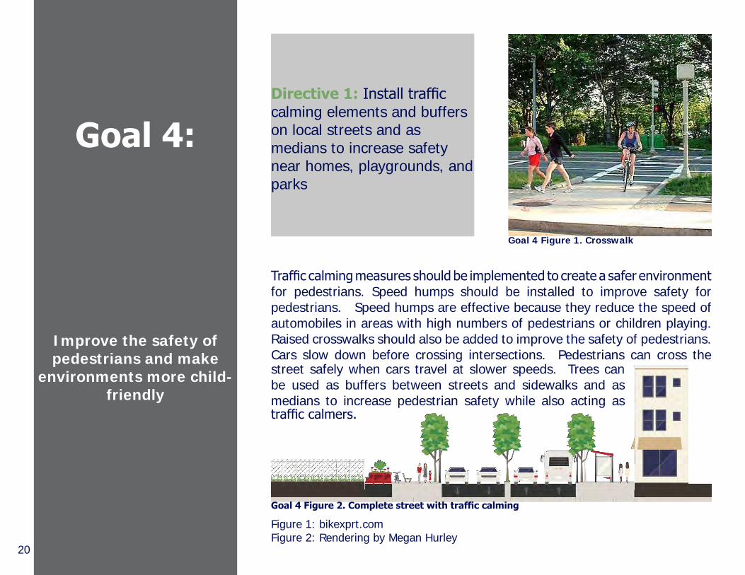
Goal 4:
Improve the safety of pedestrians and make
environments more child-friendly
Directive 1: Install traffic calming elements and buffers on local streets and as medians to increase safety near homes, playgrounds, and parks
Traffic calming measures should be implemented to create a safer environment for pedestrians. Speed humps should be installed to improve safety for pedestrians. Speed humps are effective because they reduce the speed of automobiles in areas with high numbers of pedestrians or children playing. Raised crosswalks should also be added to improve the safety of pedestrians. Cars slow down before crossing intersections. Pedestrians can cross the street safely when cars travel at slower speeds. Trees can be used as buffers between streets and sidewalks and as medians to increase pedestrian safety while also acting as traffic calmers.
Goal 4 Figure 1. Crosswalk
Goal 4 Figure 2. Complete street with traffic calming
Figure 1: bikexprt.comFigure 2: Rendering by Megan Hurley

21
Figure 3: Sketchup design by Evan BunnerFigure 4: Rendering by Megan Hurley
Goal 4
Benches and trash cans should also be installed to establish order. Benches define areas for people congregate. Covered bus stops provide a greater sense of security anand can encourage the use of public transportation. Street lights should be installed to improve the visibility on sidewalks and streets. Pedestrian scale lighting around playgrounds and parks allow for more usage of the recreational facilities in the evenings. Additionally, strategic timing for the lights to go off when the parks close in the evening will deter criminal activity overnight.
Directive 2: Install benches, street lighting, covered bus shelters at existing stops, and other public amenities throughout the neighborhood to encourage safe pedestrian travel
Goal 4 Figure 3. Speed bumps Goal 4 Figure 4. Playground with lighting
Directive 3: Install pedestrian scale lighting in areas where children play


23
ANALYSIS
Through census data, a physical inventory of the community, and
qualitative data through community outreach, we summarize the physical and socio-economic
characteristics of the neighborhood to identify strengths, weaknesses,
and goals for development.
24
Summary of AnalysesBackground:Milo-Grogan shifted from a manufacturing area of 5,000 people to a being a community of 2,500 people and losing 500 lots in the freeway projects in 1950 and 1990s.1 The community effectively became cut off from areas of Columbus and access to healthy food and healthcare. Habitat for Humanity became involved in 1987 and over the past years built 10% of the housing stock. Along with housing Habitat has worked in engaging and assisting the community with door to door surveys on neighborhood blocks, houses and the residents about neighborhood. In 2009, an Ohio State landscape architecture Neighborhood Design Studio worked with Milo-Grogan on the design and community perception and desires. The studio summarized the community as an area that has potential, is hopeful, challenged, nice, promising, charming, good and quietly neglected. In 2014, Ohio State city planning students are back in Milo-Grogan working with urban design and Community Development. In 2015, graduate students will continue the efforts looking at the sustainability in Milo-Grogan. In 2012, Habitat hosted a community event accompanied by neighborhood consultants to identify what the community found to be assets. Assets included: Associations:sports teams, Boys and Girls club, recreation center, family services, Milo-Grogan property owners, civic association, Milo Business Owner Alliance, churches, Youth to Youth and Habitat for Humanity. Cultural values: long term residents and business, diversity, history, playgrounds, religion, homes and Milo Arts. Physical values: location near downtown, freeway, Short North, Columbus State Community college and Ohio State University. Physical assets: the old train station, Homestead apartments, opportunity for community garden lots, and plans for new roads.In 2014, neighborhood revitalization initiative consultants came back with Habitat to review their extensive list of accomplishments over the last two years.2 In that time Milo-Grogan completed 2 KABOOM playgrounds and were working on a third in addition to opening the recreation center. Milo-Grogan was invited to be part of Neighborhood Pride and received numerous funding for alleys, demolition of dilapidated building and roadwork repairs, home repairs and overall curb appeal. In the end of the meeting the community determined they wanted to work on homes, community gardens, transit, increasing social activities, bring communities together, smart growth, walkability and historic value.1-HFHMO Affiliated Exit Report 11_20122-HFHMO Affiliated Exit Report 6_2014

25
This opportunity index from Kirwan Institute at Ohio State University summarizes opportunities throughout Columbus. The lighter colors on the map represent areas with less opportunity. The map shows that compared to other parts of Columbus, Milo-Grogan scores low on opportunities, including housing, neighborhood, transportation, employment, health, safety, and education.

26
Census Data
The cultural and census data assessment provides a snapshot of the demographics and cultural
makeup of Milo-Grogan. This assessment also compares some of these existing conditions within the area itself to the broader area of Columbus and Franklin County
as a whole.
The 2010 Census Data used for the majority of this report was broken down by block groups. The Milo Grogan neighborhood is contained within the five block groups. However, these block groups extend beyond Milo Grogan’s boundaries.
The Milo-Grogan neighborhood includes approximately 2,179 residents in just under 2 square miles, only 0.28% of Columbus’ total population of 787,033. Milo Grogan has 833 households. Among the neighborhood, there are approximately 461 people under the age of 18, and 125 people ages 65 and older. Based on family income levels, 39.8% of families are below the poverty level. The median age for the area’s population is 30.5 (27.9 for males and 31.6 for females). 84% of the population is African American and 11% is Caucasian.
Analysis: Figure 1. Boundary
Figure 1: Map by Hao-Ting LienFigure 2: Table by Megan Hurley

27
Figure 3: Map by Victoria DarahFigure 4: Map by Victoria Darah
Tract15-Block Group 3 and Tract23-Block Group 1 are both fully contained within the Milo Grogan boundary (shown as a red line) . The other 3 block groups are only partially contained within the boundary. Looking at land area provided a rough estimation (for example, Tract14-Block Group 2 appears to be about 50% within Milo-Grogan and 50% outside), but this is not accurate since some of the area outside of the boundary is vacant. Using this estimation would skew the data because it would give disproportionate weight to the areas outside of Milo that are empty. This would greatly impact estimations made on population data. Because there is no way to account for every single person on a map, parcel data provided the smallest scale break down for each block group.
Breakdown of the five block groups and the percentage of their areas that are included in the Milo Grogan neighborhood.
Census Data
Analysis: Figure 2. Census Tracts
Analysis: Figure 3. Block Groups
Analysis: Figure 4. Block Groups

28
The population of Milo-Grogan is extremely low in comparison to most Columbus neighborhoods. At just 2,179 residents total, it is actually smaller than many area high school student bodies. The most populous region is census tract 15-block group 3, with 579 residents, while the least popu-lous region is census tract 15-block group 1, with just 292 residents. In contrast, the city of Columbus as a whole has 787,033 residents.
The majority of Milo-Grogan residents are African American, counting for 84% of the population. 11% of residents are Caucasian. Columbus is 62% white and 28% black. By putting this data side by side, it becomes clear that Milo Grogan has a disproportionately high population of African Americans compared to Columbus, Ohio, and the United States.
Most areas of Milo-Grogan have a low population density. The least dense area is census tract 14-block group 2, at 490.3 residents per sq mi. Columbus’ average is 3,851 people per sq mi., which is ~8 times as dense. The core of Milo-Grogan (census tract 15-block group 3) is denser than the Columbus average at 3876.3 residents per sq mi.
Population RaceDensity
Analysis: Figure 5. Population
Analysis: Figure 6. Population DensityAnalysis: Figure 7. Race
Figure 5: Table by Megan HurleyFigure 6: Map by Victoria DarahFigure 7: Graph by Terel Howard

29
Figure 8: http://epmgaa.media.lionheartdms.comFigure 9: Map by Victoria DarahFigure 10: http://i.huffpost.com
About 518 of 833 households are occupied by families. 13.8% of these families are married-couple families. 40.5% of these are female headed households with no husband. This number is higher than Franklin County overall, where about 14% of households are headed by females with no husband. 207 households (~40%) have children under 18 as compared to 31% of households in Franklin County. ~54% of families in Columbus have children.
Milo-Grogan has a large number of residents under 18. Three block groups have percentages above the Columbus average (20.8%), with 31.2%, 37.0%, and 23.5% of residents under 18 years old. Census tract 15-block group 3 has the lowest percentage of children (13.6%). This could mean it is an area where solely adults locate. Milo-Grogan’s largest age cohort, consistent with the national level, is the 45-54 year-old group, while the highest in greater Columbus is the 25-34 year-old group. Columbus is known for being a “young” city. Perhaps a key to revitalizing Milo-Grogan lies in drawing more millennials into the area.
Average household income in Milo Grogan, according to the 2010 American Community Survey, was $28,331. Average family income was slightly below this, at $26,419. Based on this income, 39.8% of families were considered below the poverty level, compared to 22% of the population for the City of Columbus in its entirety.
AgeFamily Structure Income
Census Data
Analysis: Figure 9 Analysis: Figure 10Analysis: Figure 8

30
For Milo-Grogan’s population aged 25 and older, 50.7% of the residents are high school graduates, while 35.4% have less than a high school education. 13.9% of the residents attended college and there was not enough data to compile statistics for any college degrees. In comparison to the city of Columbus, 26.3% of residents are high school graduates, with 22.1% attending college and 21.9% of residents have acquired a bachelor’s degree.
In Milo-Grogan, ~34.6% of households are owner-occupied, compared to Columbus (47.0%) and Franklin County (55.4%). People living in low-income areas don’t typically own their homes. The Columbus value is lower than the Franklin County value because Columbus is a much more urban region, with many apartments (rentals). In Milo-Grogan, census tract 23-block group 2 has the highest home ownership rate (43.3%).
The area in Milo-Grogan with the highest percentage of vacant houses is census tract 23-block group 2 (32.5%); 1 of 3 houses are vacant, which is unattractive, undesirable, and unsafe. The lowest percentage of vacant houses is in census tract 15-block group 1, with 13.9%; 1 of 7 houses. The Franklin County average is 9.4%.This data proves Milo has an abnormally large number of vacant or abandoned homes.
Tenure VacancyEducation
Analysis: Figure 10. Education
Analysis: Figure 11. Tenure Analysis: Figure 12. Vacancy
Figure 10: Table by Megan HurleyFigure 11: Map by Victoria DarahFigure 12: Map by Victoria Darah

31
T14BG2:This area is the least densely populated area in Milo, with a relatively low percentage of vacant homes, a relatively high population under 18, and average owner-occupancy rate. Because it has such low density, it is not a practical area for a new development. However, with a large population of under 18 year-olds, it holds potential as a good area for large playing fields or parks.
T23BG1:This area has a relatively high population density, a relatively high vacancy rate, a relatively low percentage of under 18 year-olds, and a relatively high vacancy rate. Based on this data, this block group acts as a valid representation of the Milo-Grogan neighborhood in general.
T15BG1:This area is has the highest population of people under 18 years-old as well as the lowest percentage of vacant homes; as such, this is a good area for a new school or child-care facility because there are many children located here. Additionally, the low percentage of vacant homes contribute to facilitating a safer environment.
T15BG3:This area is the most densely populated area in Milo, with a relatively high percentage of owner-occupancy and the lowest percentage of under 18 year-olds. This region acts as the neighborhood “core,” and because of its central location and proximity to other regions, it has the potential for new businesses to flourish.
T23BG2:This area is interesting because it has the highest percentage of owner-occupied homes, but also the highest percentage of vacant units. After qualatative analysis measures, we conclude this is because there are simply not many landlords in the area who rent out homes, or they own homes but don’t live there.
Block Group
Insights
Census Data

32
Physical Inventory
Milo-Grogan has 15 churches scattered throughout the neighborhood; the residents form a fairly religious community. Vandalism is not apparent on or near religious properties, showing that the residents respect these areas.
Vacancies and blighted lots put maintained lots and streets at risk for degradation. Blighted lots are, in this report, defined as having unclean/peeling siding, overgrown vegetation, litter, etc. These lots signal decay and leave people feeling unsafe when passing through the area. The tunnel entrances leading into Milo-Grogan also degrade the appearance of the neighborhood. They leave people with a negative first impression of the area, are unsafe (lack of lighting, dark nooks, etc.), and need maintenance.
PI: Figure 1
PI: Figure 2. Existing church
PI: Figure 3. Existing tunnel
Figure 1: Created by Parikh, Yakumithis and MalloyFigure 2: Image from Google MapsFigure 3: Image by Kalindi Parikh

33
The area’s past revolves around the railroad industry. Milo-Grogan is still bound by railroad tracks, a reminder of the neighborhood’s industrial past. Another historical landmark is Milo Arts (617 E 3rd Ave), which was built in 1894 as a high school; it was later turned into an elementary school. The only other standing historical building besides Milo Arts is the Columbus Railroad, Power, and Light Company building (838 Cleveland Ave.). A few of the historically significant companies that used to reside in Milo-Grogan include Ohio Malleable Iron Company, Kilbourne & Jacobs Wheelbarrow, and Timken Roller Bearings Company, all of which have since relocated or shut down. The neighborhood was also home to a branch of the Columbus Metropolitan Library starting in 1930. The building has since been demolished.
Many homes in Milo-Grogan are maintained well. Maintained homes include clean siding, trimmed grass, intact windows, etc. These homes signal community pride and contribute to the neighborhood’s beauty. Another positive attribute of the area are the sightlines of downtown Columbus from Cleveland Avenue, an asset that should be taken advantage of.
The good lots and blighted lots contributed to the creation of a general evaluative map. This inventories the blighted, maintained, and at-risk areas of the neighborhood. Because there is no defined pattern that emerges from the evaluative map, it’s difficult to prescribe one solution for this neighborhood’s lots.
Physical Inventory
PI: Figure 4. General Evaluative Map
PI: Figure 5. Milo Arts
Figure 4: Map by Brian MalloyFigure 5: http://www.columbusalive.com

34
NodesThe nodes in Milo-Grogan have a high vehicular traffic, but have potential to attract pedestrian traffic because of nearby landmarks. Nodes are classified as primary if people were present and secondary if they were absent. The four primary nodes are located at the intersections of Cleveland Avenue and Camden Avenue, Cleveland Avenue and East 5th Avenue, Cleveland Avenue and East 2nd Avenue, and St. Clair and East 5th Avenue.
Cognitive Map People can orient and find their way around in areas that have clear cognitive maps. Kevin Lynch introduced the concept of cognitive mapping. He found five components; landmarks, nodes, edges, paths, and districts. A landmark is defined as a structure used for orientation and navigation within the city. A node is defined as a strategic focus point people pass through, such as a square or intersection. A path is defined as a route people travel along throughout the city. An edge is a linear element that creates boundaries between areas. A district is characterized by the architecture and urban form that lies within the boundaries and edges.
PI: Figure 6. Cognitive Map PI: Figure 7. Landmarks PI: Figure 8. Gathering Places
Landmarks Milo-Grogan has three positive landmarks and four in need of improvement. The newly constructed Milo-Grogan Community Rec Center located on 2nd Ave., the rehabilitated Milo Arts on 9th and 3rd Ave., and the New Beginnings Park on St. Clair all assist with navigation and orientation and are positive assets for the community. The large, empty Timken site on Cleveland and 5th Ave., the water tower to the east of Timken, the Central Ohio Transit Authority station south of the railroad on Fields, and the adjacent Rumpke site all need improvement to be more attractive and pedestrian friendly.
Figures 6-11: Maps created by Ashbaugh, Barr, and Bunner

35
Edges & DistrictsThe railroad tracks are the hard exterior edges that limit movement in and out of Milo-Grogan. Interstate 71 bisects the neighborhood and the sound wall forms a barrier between the highway and residences.
***For complete details, see Appendix B.
PathsThe paths in Milo-Grogan accommodate a high amount of vehicular traffic at moderate speeds. The high volume of traffic detracts from the small neighborhood in that it creates an unwelcoming environment for pedestrians. Sidewalks in the neighborhood are also in disrepair and deter pedestrians from walking. Some blocks do not have sidewalks and force pedestrians to share the roadway with motorists. The environment is also unwelcoming for cyclists that may use the paths to commute. Cleveland Avenue is the north-south
Physical Inventory
PI: Figure 9. Paths PI: Figure 10. Edges
route through which most traffic enters and exits Milo-Grogan. Fifth Avenue is the east-west route that also has a large amount of traffic. Additional paths are collinear with a portion of the northern boundary, 11th Avenue. St. Clair Avenue is the third path that provides access to a large portion of the residential areas on the east side of Interstate 71.The high amount of vehicular traffic and disrepaired or missing sidewalks in Milo-Grogan discourage pedestrians and cyclists. The three most prominent paths through the neighborhood are Cleveland Ave., Fifth Ave., and St. Clair Ave.
PI: Figure 11. Districts

36
Community Outreach
Community outreach is a way of determining whether the
community’s needs and desires are satisfied throughout the planning process. The Ohio State University
City and Regional Planning students met monthly with the
Milo-Grogan Area Commission to update them on the progress and ask for suggestions. The students spent time working on site talking to residents. Students have also gone on numerous site visits and attended the City of Columbus’ Neighborhood Pride Program to see the changes occurring in the
neighborhood.
The initial analysis on Milo-Grogan expressed the neighborhood’s need for stronger links and connections within and outside the neighborhood. The community also wants to draw higher educated residents into Milo-Grogan. In order to achieve these ambitions, Milo-Grogan needs to establish a link to downtown Columbus and surrounding neighborhoods. To discover what Milo-Grogan is lacking that other successful Columbus neighborhoods have, we developed an analysis of neighborhood needs through community outreach and surveys.
The Area Commission expressed a concern with discovering a way to bring more residents into the areas as well as attracting young business professionals into the area. Through our surveys, we found that the most important aspect for Milo-Grogan to combat is the establishment of a neighborhood identity. Only one Columbus State student out of thirty had heard of Milo-Grogan. Additionally, Milo-Grogan lacks basic resources that communities need in order to flourish, like a post office or a grocery store.
CO: Figure 1. Nearby Neighborhoods
Figure 1: Google Earth image rendered by Colin HallFigure 2: Habitat for Humanity Survey map

37
Habitat for Humanity was an important asset to access data and surveys on the neighborhood. Two members of the studio partnered with Habitat for Humanity to collect and analyze data on their extensive door-to-door survey collection. The partnership with Habitat for Humanity gives Ohio State University students access to Geographical Information System (GIS) based data on their ongoing analysis of the area. The information can help locate areas which lack safety and/or basic necessities. The survey information is being processed through success measures and the community will be given access to the data upon completion. The GIS information can then be shown to businesses and developers to convey the demand and the number of potential clients in the area for a certain industry in Milo-Grogan. Increasing the amount of local businesses will encourage residents to do their shopping or banking inside of Milo-Grogan, rather than being forced to go outside of the community to complete these tasks.
Community Outreach
CO: Figure 2. Survey Areas
Figure 1: Image by Colin HallFigure 2: Image by Sarah Galbreath


Figure 1: CITATIONFigure 2: CITATION etc
39
IMPLEMENTATION
After analyzing the community and outlining its goals, we created an implementation plan to help make the aspirations of Milo-Grogan a reality. For each design idea, the plan describes the actors and resources needed to make it happen, and the time frame.

40
Short Term Goals
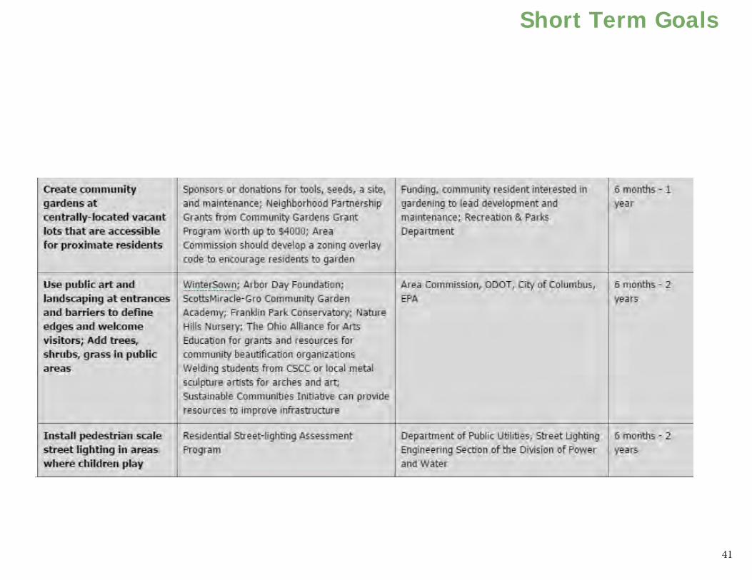
41
Short Term Goals

42

43
Intermediate Goals

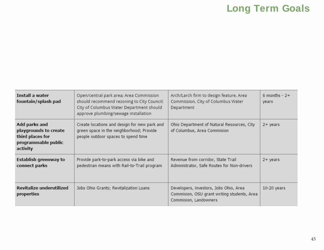
44
Long Term Goals
45
Long Term Goals

46

47
Timeline

48
Create third places and improve aesthetic qualities for young professionals:The Ohio Department of Taxation provides tax exemptions of up to 50% of the $250,000 of income to small businesses. A community member should lead a workshop to teach business owners how to fill out the forms
1 for
tax exemption at the Milo-Grogan Recreation Center along with a general tax exemption form2. The workshop would serve as a community development event to establish more resident-business rapport and empowerment.
Lower speed limits near playgrounds & parks: The Area Commission can request lower speed limits on a street by submitting a proposal to the Ohio Department of Transportation (ODOT). Response (approval or denial) takes between three to six months. In April 2014, legislators introduced amendments to House Bill 523, which if passed, allows residents to request the Director of Transportation to reduce speed limits to 35 mph on roads where they live. The residents can also request stop signs at intersections without them.
Establish greenway to connect parks:Federal and private sources provide funding for both active and inactive rails. The Rail-to-Trail group offers a popular and conventional rail-to-trail conversion assistance. However, for the active freight rail lines around the neighborhood, one would have to place a trail next to the railroad.
Add parks and playgrounds to create third places for public activity: The Ohio Department of Natural Resources offers the Nature Works Grant, which reimburses up to 75% of the cost for acquisition, development, and rehabilitation of recreational areas (application deadline, May 1, annually). The Columbus Foundation offers the Scotts Miracle-Gro Community Garden academy grant up to $4,000) for initial and maintenance funding for community gardens and green space. For information, see the Columbus Foundation website: columbusfoundation.org.
Details of Implementation
1- http://www.tax.ohio.gov/portals/0/forms/ohio_individual/individual/2013/PIT_SmallBusinessDeduction_Schedule.pdf2- http://www.tax.ohio.gov/portals/0/forms/fill-in/sales_and_use/exemption_certificates/ST_STEC_B_FI.pdf

49
Use blank walls for art murals:To obtain funding, the Area Commission should apply for a Public Art Grant from the Greater Columbus Art Council. The Area Commission should identify a talented writer in the community to write the grant proposal. The Area Commission, with resident input, should identify suitable blank walls or sites for new walls for murals. Local and university artists, school art classes, recreation center art classes, and the general public should take part in the mural’s design after the site and the commission has received funding. Depending on the site and funding, it should take about three to six months to complete the first mural.
Create a logo for Milo-Grogan and incorporate it into publications:To adopt a logo for Milo-Grogan, the Area Commission should apply for a Community Development Block Grant (CDBG). Once funded, the Area Commission could hire a graphic designer to create the logo or it could organize a competition for local students or for college students from Columbus State Community College, Ohio State University or the Columbus College of Art and Design. The CBDG could provide funds for a prize. The Area Commission should then adopt the logo and include it in entry signs, street signs, publications, and other neighborhood identifiers.3
Install a water fountain or splash pad: The Area Commission should identify a site to install the splash pad. The studio recommends the Timken site based on its proximity to 5th and Cleveland Avenues, which the Physical Inventory identifies as primary paths. The Area Commission should insure that the city zones the site for the needed utilities. It should also consult the City of Columbus Public Utilities Water Department to identify existing water lines. The Area Commission should hire a landscape architect, who with resident input, would design and construct the park. This should take about six months to a year to complete.
3- http://columbus.gov/Templates/detail.aspx?id=544

50
Create a community garden at centrally located vacant lots that are accessible for proximate residents: Urban agriculture involves the sale of produce from community gardens for profit, from which the resident gardeners can benefit. The Community Gardens Grant Program by the Neighborhood Partnership Grants of Columbus offers grants of up to $4,000. The neighborhood should use the grant and private funding to purchase a viable site, tools, seeds, and general maintenance. A resident with gardening experience should lead the project. The Area Commission may need to propose an overlay zoning code to City Council to allow sales and to increase residents’ awareness of urban agriculture on vacant sites. Urban agriculture has multiple benefits such as greening, community building, crime reduction, job training, employment, and economic development. The first community garden should be operating within six months to a year after funding is acquired.
Use public art and landscaping at entrances and barriers to define edges and welcome visitors:The Area Commission should apply for resources from local hardware stores, university horticulture departments, the Recreation and Parks Department, Winter Sown, Nature Hills Nursery, and The Arbor Day Foundation. These businesses and organizations could provide soil testing, seeds and trees to communities in need of landscaping and foliage. The Franklin Park Conservatory and The Scotts Miracle-Gro Community Garden Academy Grant has funding to neighborhood organizations seeking to beautify the area with landscaping. The Area Commission should get a grant writer to apply for these grants. Volunteers from the community, such as children from the Boys and Girls Club, could plant foliage around the entrances to create pride and ownership. The landscaping should take up to a year. Volunteers should also organize litter cleanups within a month clean the land near the entrances. The Franklin County Neighborhood Arts program provides funding for community art. The Area Commission should request labor and materials from Columbus State Community College welding classes, or by local sculpture artists.
Install pedestrian scale lighting in areas where children play:The Area Commission or residents should apply to the Department of Utilities for the Residential Streetlight Assessment Program (RSAP). The RSAP evaluates streets submitted by residents to determine if the streets have adequate lighting. If not, the RSAP determines the preferable type. Assessment may take up to one or two years.
Details of Implementation

51
Install wayfinding cues to define edges of the neighborhood and assist with navigation: The Area Commission should apply to the Columbus Foundation for the Neighborhood Partnership Grants (deadline, January 23, 2015, disbursement June 2015). Once funded, the Area Commission should select a designer and contractor. To improve wayfinding, the Area Commission should: 1) identify the landmarks in addition to those mentioned in the Physical Inventory; 2) complete park or facility improvements referenced in other directives; 3) adopt a logo.
Delineate bike paths:The Area Commission should apply to the Columbus Foundation for two $10,000 Neighborhood Partnership Grants to construct a bikeway (deadline, Jan 23, annually). It can use the grant money to buy bike-lane green and white paint, to hire a company to install bikeway infrastructure, and to install pedestrian crosswalks.
Install territorial markers around designated play areas, especially near busy roads, and ensure there are at least two points of access to the space:Property owners should install boundary markers. Once The Area Commission has selected park location, it should apply for the NatureWorks Grant from the Ohio Department of Natural Resources to install play areas with these necessary boundaries. The NatureWorks Grant reimburses up to 75% of the cost for the acquisition, redevelopment, and rehabilitation of public parks and recreational areas.
Establishing pedestrian crosswalks:The Area Commission should submit a request to the City’s 311 Service Center for crosswalks at intersections where the neighborhood feels they are necessary. An account needs to be made on the 311 Service Center website at 311.columbus.gov. To provide evidence of the need for a crosswalk, the Commission should organize an informal traffic study to count how many pedestrians and vehicles cross an intersection in a day. To test the viability of a crosswalk, residents should use chalk to mark crosswalks.
52
Install traffic calming elements on local streets to increase safety near homes, playgrounds, and parks: The State Capital Improvement Program (SCIP) and Local Traffic Improvement Program (LTIP) provide funding for modifications in the right of way. The Area Commission should submit an application for the Ohio Public Works Commission Financial Assistance Form to a representative at the Mid-Ohio Regional Planning Commission. The application needs a cost estimate from a Professional Engineer, approval by the Columbus City Council, and a Cooperation Agreement with Franklin County, and match funding from the City or private sponsors.
Maintain the tunnels at the edges of the neighborhood:The Area Commission should get the on-line forms to request maintenance of the tunnels by the companies that own them, CSX and Norfolk & Western. Depending on the railway response time, this may take up to five years.
Establish seating areas with good views and open vistas with historically themed street furniture:The Area Commission should apply for Transportation Investment Generating Economic Recovery (TIGER) grants for bicycle and pedestrian improvements, which could include historical furniture. Offered annually, the grant provides $100,000 to $65,000,000 for collaborative projects to establish a strong pedestrian network.
Incorporate play areas into places with plenty of eyes on the street: The Area Commission should commission a study of the neighborhood to identify the best locations for play areas (heavy pedestrian traffic, lots of children nearby, eyes on the street). The Area Commission should seek funding for the play areas through private parks and recreation grants. Partnerships through the Columbus Recreation and Parks Department and private and in-kind funding could help purchase the sites. The Area Commission would need to obtain additional funding to build and maintain the play areas.
Details of Implementation

53
Preserve and improve historic structures:The Area Commission should apply for the Transportation Enhancement Program (TEP) and the Ohio History Connect grant. The TEP provides potential funding for the rehabilitation of a building along a regional transportation system and used by that system on behalf of the Columbus Railway, Power, and Light Company for projects between $500,000 and $1,000,000 (deadline May 1, annually). The Columbus Railway, Power and Light Company building, at Cleveland Avenue and Reynolds Avenue, fits. The Central Ohio Transit Authority (COTA) routes 1, 9, 27, and 35 run by this site and have stops on Cleveland Avenue.
The Ohio History Connect grant provides funding to rehabilitate historic buildings to usable conditions. The Area Commission could use this for the Columbus Railway, Power and Light Company building as well as others. The rehabilitated building could serve the community as a resource center. It or others might become a post office, library or a health care clinic.
Revitalize underutilized properties:The community can revitalize the front entrance of Cleveland Avenue, clean up or repurpose dilapidated buildings, create gathering places and create jobs in three ways. JobsOhio offers a Revitalization Loan that provides $500,000 to $5 million for demolition, site preparation, environmental remediation and infrastructure. The redevelopment project must provide at least twenty jobs, and the project must start within five years of negotiation. Businesses, non-profits or local governments can apply. The Area Commission can apply for the City of Columbus’ Land Redevelopment Grant to revitalize vacant properties to attract small businesses. Private investors can contact the Columbus Land Bank to acquire vacant land of Milo-Grogan fro redevelopment.


Figure 1: CITATIONFigure 2: CITATION etc
55
APPENDICES

56
Appendix A: Census ReportCULTURAL & CENSUS DATA The cultural & census data piece of the Environmental Assessment provides a snapshot of the demographics and cultural makeup of the Milo Grogan neighborhood. This element also compares some of these existing conditions within the area itself, to the broader area of Columbus, and Franklin County as a whole.
BACKGROUND & METHODS The 2010 Census Data used for the majority of this report was broken down by block groups. The Milo Grogan neighborhood is contained within the five block groups shown in Figure X. However, these block groups extend beyond Milo Grogan’s boundaries. Tract15-Block Group 3 and Tract23-Block Group 1 are both fully contained within the Milo Grogan boundary (shown as a red line). The other 3 block groups, however, are only partially contained within the boundary. Creating a proper method for estimation required careful strategizing. Looking at land area provided a rough estimation (for example, Tract14-Block Group 2 appears to be about 50% within Milo-Grogan and 50% outside), but this wouldn’t necessarily be accurate because much of the area outside of the boundary is vacant. Using this estimation would skew the data because it would
give disproportionate weight to the areas outside of Milo that are empty. This would greatly impact estimations made on population data. Because there is no way to account for every single person on a map, parcel data provided the smallest scale break down for each block group. Overlaying a parcel shapefile for Franklin County on a separate shapefile showing the boundaries of block groups and using the “Select by Location” feature in ArcMap, enables the 5 block groups to be broken down into 5 separate groups of parcels. The shapefile used already had the number of parcels included in the attribute table, so it was easily countable. In order to be consistent throughout the remainder of this report, any and all data pertaining to Milo Grogan specifically, and all areas contained within it, were calculated based on these estimations.
SUMMARY The Milo-Grogan neighborhood includes approximately 2,179 residents in just under 2 square miles, just 0.28% of Columbus’ total population of 787,033. Within Milo Grogan, there are approximately 461 people under the age of 18 in Milo Grogan, and 125 people ages 65 and older, among the neighborhood’s 833 households. Based on family income levels, 39.8% of families are below the poverty level. The median age for the
area’s population is 30.5 (27.9 for males and 31.6 for females). 84% of the population is African American and 11% is white.
FINDINGS & ANALYSIS-- POPULATION The population of Milo-Grogan is extremely low in comparison to most Columbus neighborhoods. At just 2,179 residents total, it is actually smaller than many area high school student bodies. The most populous region is census tract 15-block group 3, with 579 residents, while the least populous region is census tract 15-block group 1, with just 292 residents. In contrast, the city of Columbus as a whole has 787,033 residents. Because Milo-Grogan is such a small neighborhood, one can already conclude that drawing new residents into the area will be a necessity in order to sustain new schools, businesses, or other potential ventures.
-- DENSITY In addition to having a small population, most areas of Milo-Grogan also have an extremely low population density. The least densely populated area is census tract 14-block group 2, with just 490.3 residents per square mile. In contrast, the average for the city of Columbus is 3,851 people per square mile, which nearly 8

57
times as dense. Interestingly, though, the “core” of Milo-Grogan (census tract 15-block group 3) is more dense than the Columbus average, coming in at 3876.3 residents per square mile. Based on this demographic data, one could conclude that there exists a central sub-region of Milo-Grogan where most residents are clustered, perhaps in multi-family unit housing. The inequality in population density among the five block groups could potentially allude to a clustering in the location of vacant houses, which will be explored later in the report.
-- RACE The majority of Milo Grogan residents, 84%, are African American and 11% of residents are White. In contrast, Columbus, is 62% white and 28% black. By comparing this data side by side, it becomes clear that Milo Grogan has a disproportionately high population of African Americans compared to not only the immediately surrounding geographies, but also the entire country.
-- FAMILY STRUCTURE Of the 833 households in Milo Grogan, about 518 of these are occupied by families. Only 13.8% of these families are traditional married-couple families. 40.5% of these are female headed households with no husband present. This number is significantly higher than in Franklin County, where only about 14% of households are headed by females with
no husband present. 207 households (or around 40%) in Milo have children under 18 living in them, compared to 31% of households in Franklin County. About 54% of families in Columbus, or just under 95,000 families, have related children under the age of 18.
-- AGE Compared to the Columbus average of 20.8%, Milo-Grogan has a relatively high percentage of residents under 18. Three of the five block groups have percentages above the Columbus average: census tract 14-block group 2, census tract 15-block group 1, and census tract 23-block group 2, with 31.2%, 37.0%, and 23.5% of residents under 18-years old, respectively.Interestingly, the idea identified above as most dense (census tract 15-block group 3) also has the lowest percentage of children with just 13.6%. This could mean it is an area where families tend not to locate, or perhaps a large number of non-children live here and might be skewing the results. In Milo-Grogan, the largest age cohort is the 45-54 year-old group, which is consistent with the national level, while the highest in greater Columbus is the 25-34 year-old group. These results are not necessarily surprising, because the city of Columbus is known for being a relatively “young” city, but perhaps the key to revitalizing Milo-Grogan lies in drawing more of these millennials into the area.
-- INCOME Average household income in Milo Grogan, according to the 2010 American Community Survey, was $28,331. Average family income was slightly below this, at $26,419. Based on this income, 39.8% of families were considered below the poverty level, compared to 22% of the population for the City of Columbus in its entirety.
--EDUCATION For the Milo-Grogan’s population aged 25 and older, 50.7% of the residents are high school graduates, while 35.4% have less than a high school education. Only 13.9% of the residents attended college and there was not enough data to compile statistics for any college degrees. In comparison to the city of Columbus, 26.3% of residents are high school graduates, with 22.1% attending college and 21.9% of residents have acquired a bachelor’s degree.
--TENUREIn Milo-Grogan, approximately 34.6% of households are owner-occupied, while in Columbus 47.0% are owner-occupied, and in Franklin County, 55.4%. This is not surprising because people living in low-income areas do not typically own their own houses. Additionally, the Columbus value is lower than the Franklin County value because the city of Columbus is a much more urban region, with many apartments and high-rise flats available

58
for rent. In Milo-Grogan, the region with the most owner-occupied houses is census tract 23-block group 2, at 43.3%. This region could potentially be a strength because homeowners tend to have more pride in their property, which subsequently leads to a safer and more attractive area.
--VACANCY The area in Milo-Grogan with the highest percentage of vacant houses is census tract 23-block group 2 at 32.5%. This is startling because that essentially means 1 in every 3 households is vacant, which is not only unattractive and undesirable, but potentially unsafe. The area in Milo-Grogan with the lowest percentage of vacant houses is census tract 15-block group 1, with 13.9% - this is a much better rate, at about 1 in every 7 households. In comparison, the Franklin County average is 9.4%, or 1 in every 10 households. This data is significant because it proves Milo has an abnormally large number of vacant or abandoned homes.
BLOCK GROUP INSIGHTS Demographic factors were cross-examined in this section according to each individual block group, in order to identify the essence of each region. T14BG2: This area is the least densely populated area in Milo, with a relatively low percentage of vacant homes, a relatively high population under 18,
and average owner-occupancy rate. Because it is so low-density, it would probably not be an advisable area for a new development. However, with a large population of under 18 year-olds, it could be a good area for large playing fields or parks. T15BG1: This area is has the highest population of people under 18 years-old as well as the lowest percentage of vacant homes; as such, it would be a good area for a new school or child-care facility because there are many children located here. Additionally, the low percentage of vacant homes would hopefully facilitate a safer environment. T15BG3: This area is the most densely populated area in Milo, with a relatively high percentage of owner-occupancy and the lowest percentage of under 18 year-olds. One could think of this region as the neighborhood “core,” and because of its central location and proximity to other regions, it has the potential for new businesses to flourish. T23BG1: This area has a relatively high population density, a relatively high vacancy rate, a relatively low percentage of under 18 year-olds, and a relatively high vacancy rate. Based on this data, one could assume this block group is pretty representative of the Milo-Grogan neighborhood in general. T23BG2: This area is interesting because it has the highest percentage of owner-occupied homes, but also the highest percentage of vacant units. This
could be because there are simply not many landlords in the area who rent out homes, or own homes but don’t live there.
59
Appendix B: Physical Inventory ReportIntroduction People can orient and find their way around in areas that have clear cognitive maps. Kevin Lynch introduced the concept of cognitive mapping. He found five components; landmarks, nodes, edges, paths, and districts. A landmark is defined as a structure used for orientation and navigation within the city. A node is defined as a strategic focus point people pass through, such as a square or intersection. A path is defined as a route people travel along throughout the city. An edge is a linear element that creates boundaries between areas. A district is characterized by the architecture and urban form that lies within the boundaries and edges. (see Figure 1) The combination of all of these components annotates a city or neighborhood within a city. By indicating the notable points and lines in an area, it enables the viewer to determine the strengths and weaknesses of the area geographically. Once strengths and and weaknesses are determined, goals can be established.
Landmarks: Existing conditions The neighborhood of Milo-Grogan has seven landmarks within its borders. Because landmarks are used for navigation and orientation, it is important that they are memorable for positive reasons.
The neighborhood has three positive landmarks, but the remaining four have room for improvement. The Milo-Grogan Community Rec Center is the first positive landmark. It is located on East 2nd Avenue. The City of Columbus recently funded the new construction, which is now a focal point of the community. Milo Arts is the second landmark, located on the corner of North 9th Avenue and East 3rd Avenue. The rehabilitated former school building in the neighborhood that has found a new purpose in the community. New Beginnings Park is the third positive landmark. It was recently constructed on St. Clair Avenue. Area youth gather and socialize at these positive landmarks. Milo-Grogan’s four remaining landmarks are in need of improvement. The Timken site is the first negative landmark. Due to its large size and its location on a prominent intersection at Cleveland Avenue and East 5th Avenue, it is need of redevelopment. The water tower to the east of the Timken site is the second negative landmark. Repair is necessary due to its prominent location adjacent to the empty lot. The Central Ohio Transit Authority station is the third negative landmark, located south of the railroad tracks on Fields Avenue. The building is a new construction when compared to other structures in the neighborhood. The significant amount of
parking is not conducive to a pedestrian environment. The Rumpke location adjacent to the COTA location is the fourth negative landmark. many visible dumpsters in addition to trash collection trucks and the building exterior are in need of repair. Milo-Grogan has three positive landmarks and four in need of improvement. The newly constructed Milo-Grogan Community Rec Center located on 2nd Ave., the rehabilitated Milo Arts on 9th and 3rd Ave., and the New Beginnings Park on St. Clair all assist with navigation and orientation and are positive assets for the community. The large, empty Timken site on Cleveland and 5th Ave., the water tower to the east of Timken, the Central Ohio Transit Authority station south of the railroad on Fields, and the adjacent Rumpke site all need improvement to be more attractive and pedestrian friendly. (see Figure 2)
Nodes: Existing Conditions The nodes in Milo-Grogan are not used frequently by pedestrians, but they do have larger rate of vehicle exchange. The nodes have potential to be more active for pedestrians because of the landmarks near them. The nodes have been classified as primary and secondary, according to whether or not people were outside at the following locations. The nodes in Milo-Grogan have a

60
high vehicular traffic, but have potential to attract pedestrian traffic because of nearby landmarks. Nodes are classified as primary if people were present and secondary if they were absent. The four primary nodes are located at the intersections of Cleveland Avenue and Camden Avenue, Cleveland Avenue and East 5th Avenue, Cleveland Avenue and East 2nd Avenue, and St. Clair and East 5th Avenue. The four primary nodes are located at the following intersections: Cleveland Avenue and Camden Avenue, Cleveland Avenue and East 5th Avenue, Cleveland Avenue and East 2nd Avenue, and St. Clair and East 5th Avenue. The Cleveland and 5th intersection is likely the largest node in the neighborhood, due to the width of Cleveland and the connection 5th provides to the Short North. However, it is currently under construction and has the vacant Timken site at its southwest corner. The Cleveland and Camden intersection is near I-71, but due to the smaller size of Camden, it is not as prominent. The Cleveland and 2nd intersection is in a primarily residential area, but is still a large node because Cleveland is the anchor. The St. Clair and 5th intersection has a large right of way, but not a lot of space for pedestrian activity. The setbacks are deep and parking exists as Keen’s Body Shop, which is not inviting for pedestrians. The two secondary nodes are located at the following intersections: Lexington
Avenue and East 5th Avenue, and St. Clair and 2nd Avenue. The node at Lexington and 5th has a vacant lot at the northwest corner, which is across the street from a gas station. The houses near the node are also set back rather far from the right of way, which is not supportive of a pedestrian environment. The node at St. Clair and 2nd is anchored by the Community Rec Center. The building across the street has potential to be developed into a different use that complements the Rec Center. (see Figure 3)
Paths : Existing conditions The paths in Milo-Grogan accommodate a high amount of vehicular traffic at moderate speeds. The high volume of traffic detracts from the small neighborhood in that it creates an unwelcoming environment for pedestrians. Sidewalks in the neighborhood are also in disrepair and deter pedestrians from walking. Some blocks do not have sidewalks and force pedestrians to share the roadway with motorists. The environment is also unwelcoming for cyclists that may use the paths to commute. Cleveland Avenue is the north-south route through which most traffic enters and exits Milo-Grogan. Fifth Avenue is the east-west route that also has a large amount of traffic. Additional paths are collinear with a portion of the northern boundary, 11th Avenue. St. Clair Avenue
is the third path that provides access to a large portion of the residential areas on the east side of Interstate 71. The high amount of vehicular traffic and disrepaired or missing sidewalks in Milo-Grogan discourage pedestrians and cyclists. The three most prominent paths through the neighborhood are Cleveland Ave., Fifth Ave., and St. Clair Ave.Edges: Existing conditions Railroad tracks serve as the hard edge that defines the neighborhood of Milo-Grogan. The number of roads that can enter and exit the neighborhood are limited due to the railroad tracks. The paths mentioned above are those streets. Interstate 71 and the sound walls that border it serves as an interior edge of Milo-Grogan. The highway bisects the neighborhood into western and eastern halves. The sound wall forms both an edge and a barrier between the highway and surrounding residential homes. The railroad tracks are the hard exterior edges that limit movement in and out of Milo-Grogan. Interstate 71 bisects the neighborhood and the sound wall forms a barrier between the highway and residences.
Districts: Existing conditions Differences in lot sizes, orientation of structures, land use, and architecture all define districts. Commercial and industrial structures in the first district are bounded by the railroad tracks to the west and Cleveland Avenue to the east. The COTA

61
Conclusions Based on the existing conditions of Milo-Grogan, it can be concluded that the neighborhood is lacking in its public realm, both in appearance and safety. Strengths in the area are related to its sense of community based on the existing Community Rec Center and the Milo Arts, but the connectivity for residents needs improvement. Landmarks in the area should reflect the history of the neighborhood while also providing a sense of orientation for residents and visitor to contribute to the activity in the nodes. Boundaries should define the districts within the neighborhood, but not hinder the connectivity. Milo-Grogan has the framework it needs to develop a stronger sense of place and safer public realm within its place in Columbus.
station, Rumpke and the Timken Site are located in this district. Single family housing in the second district are by 5th Avenue to the north, Cleveland Avenue to the east, and I-71 to the west. The condition of the houses vary from well to poorly maintained. Commercial and restaurant uses are also located on 5th Avenue. The Milo Arts and Boys & Girls Clubs are located in this district. Commercial and restaurant uses in the third district are bounded by I-71 to the west, a block of St. Clair Avenue to the east, and both 5th Avenue and Shoemaker Avenue to the south. Businesses along the northeast corner of the district are near the railroad tracks. Single family housing is also distributed throughout this district. Single family homes in the fourth district are bounded by 5th Avenue to the north, I-71 to the east, and St. Clair Avenue to the west. The Milo- Grogan Community Rec Center and the Triedstone Missionary Baptist are also located in this district. Large commercial lots with single family housing in the fifth district are bounded by St. Clair Avenue to the west, railroad track to the east, and Shoemaker Avenue to the north. This district is less compact and dense compared to the other districts in Milo Grogan. New World Recycling and Higher Grounds Always Abounding Assemblies, Inc. are located in this district. (see Figure 4)
62
Appendix C: Survey Report
Figure 1-3: Graph by Colin Hall
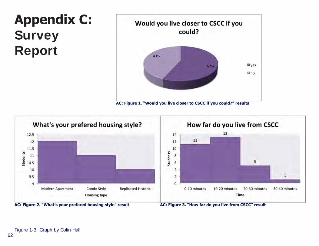
AC: Figure 1. “Would you live closer to CSCC if you could?” results
AC: Figure 2. “What’s your prefered housing style” result AC: Figure 3. “How far do you live from CSCC” result
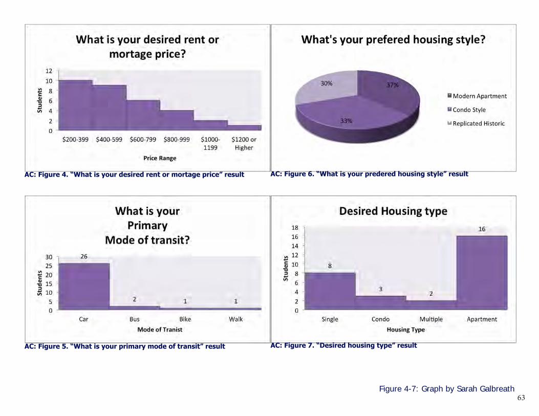
63Figure 4-7: Graph by Sarah Galbreath
AC: Figure 4. “What is your desired rent or mortage price” result
AC: Figure 5. “What is your primary mode of transit” result
AC: Figure 6. “What is your predered housing style” result
AC: Figure 7. “Desired housing type” result

64AC: Survey Created by Sarah Galbreath and Colin Hall
google image google image google image

65

66
Milo
-Gro
gan
Com
mun
ity P
lan
CRP 4910SAutumn
2014