Middle Miocene molluscan assemblages from Mae Moh coal mine, Lampang, northern Thailand
9
ScienceAsia ScienceAsia ScienceAsia ScienceAsia ScienceAsia 31 (2005): 31 (2005): 31 (2005): 31 (2005): 31 (2005): 183-191 Middle Miocene Molluscan Assemblages in Mae Moh Basin, Lampang Province, Northern Thailand Wickanet Songtham a , Hiroaki Ugai b , Suvapak Imsamut a , Somkiat Maranate b , Wattana Tansathien a , Assanee Meesook a and Wirote Saengsrichan a a Bureau of Geological Survey, Department of Mineral Resources, Bangkok, Thailand b Goshoura Cretaceous Museum, Goshoura-cho, Kumamoto Prefecture, Japan Received 9 Jul 2004 Accepted 14 Feb 2005 ABSTRACT: Molluscan beds in the Mae Moh basin have been observed and studied. Each individual molluscan bed has its own unique assemblage and occurs in a stratigraphic succession which allows for close stratigraphic correlations to be made within the Middle Miocene Mae Moh Group. Each molluscan species occurs in a particular facies showing close relationship between each taxon and its habitat. ?Paludina occurs in claystone and ligneous claystone indicating that its habitat was a lake with no vegetation or only sparse vegetation growing around it. Specimens of the Family Planorbidae must have preferred living in swamp containing dense vegetation since they occur in coal beds and ligneous claystone. Melanoides sp. cf. M. tuberculata occurs in claystone, suggesting that their habitats were in lake with little or no vegetation growing in it, similar to the living Melanoides tuberculata, which is a burrower into the lake sediments. The specimens of the Genus Bellamya have probably lived in the same conditions as Melanoides sp. cf. M. tuberculata did but not burrow. The twelve metre-thick Bellamya Bed was formed by a dynamic sedimentary process rather than by snail dying and being deposited in situ. The snails were regarded as being somehow transported for a short distance. This thick shell bed has been probably interpreted as the result of water level changes in the Mae Moh Lake under a desiccation regime. Viviparous snails such as Margarya occurred in a restricted local swamp of a fluvial system at a time when the Huai Luang Formation was deposited. Faunal changes in the molluscan assemblages have been occurred in direct response to the changes of their depositional environment. INTRODUCTION A nearly twelve metre-thick shell bed was discovered in the southwest margin of the coal pit in 2003 by a mine staff of the Mae Moh coal mine. The staffs of the Department of Mineral Resources (DMR) were strongly encouraged by this discovery to investigate the shell bed to get a detailed record for pictures and its significance. The shell bed was dominated by freshwater mud snails, Bellamya, and rare occurrences of tiny spire snails, Bithynia. This is, however, not the first discovery of a shell bed in the Mae Moh basin. Previously, the shell beds have been found in many localities and at many stratigraphic levels in the area of coal mine. The Bellamya Beds were found frequently during mine activities, but they were just thin layers with no interest to miners. The present shell bed is newly discovered and is now regarded as the thickest shell bed in Thailand, and is probably thickest freshwater shell bed in the world. The DMR hopes to conserve this fossil site as a national heritage site and to develop the site to become a geopark. This paper discusses not only the thick Bellamya bed but also other shell beds in those horizons that provide a picture of the development of molluscan assemblages during the Middle Miocene time. These include molluscan assemblages of Bellamya, Bithynia, Planorbidae, Viviparidae, Melanoides sp. cf. M. tuberculata and Margarya. A gastropod taxon, previously identified as Paludina, 1 is herein considered as unidentifiable, because the shells are always fragile and incomplete to identify. However, we will refer to this taxon as ?Paludina, with a question mark, until further study by good fossil material becomes possible. This paper reports on molluscan fossils from the Mae Moh Basin including these additional well preserved specimens as well as those at the opening of this coal mine. However, the significance has never been formally discussed in publications. We also present information on the geology and palaeontology, with particular respect to their biostratigraphic significance. GEOLOGY The Mae Moh basin is situated in the Mae Moh District of Lampang Province, which is about 26 kilometres east of Lampang City (Fig 1). It is distributed in the area of about 135 square kilometres, 7 kilometres in east-west and 16 kilometres in north-south. The
-
Upload
wickanet-songtham -
Category
Documents
-
view
217 -
download
3
description
freshwater mollusk assemblages from Mae Moh mine, Lampang, Thailand
Transcript of Middle Miocene molluscan assemblages from Mae Moh coal mine, Lampang, northern Thailand
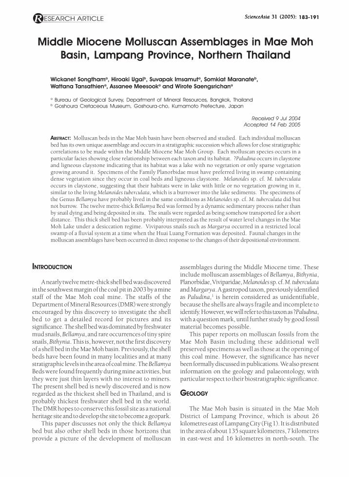
ScienceAsia ScienceAsia ScienceAsia ScienceAsia ScienceAsia 31 (2005):31 (2005):31 (2005):31 (2005):31 (2005): 183-191
Middle Miocene Molluscan Assemblages in Mae MohBasin, Lampang Province, Northern Thailand
Wickanet Songthama, Hiroaki Ugaib, Suvapak Imsamuta, Somkiat Maranateb,Wattana Tansathiena, Assanee Meesooka and Wirote Saengsrichana
a Bureau of Geological Survey, Department of Mineral Resources, Bangkok, Thailandb Goshoura Cretaceous Museum, Goshoura-cho, Kumamoto Prefecture, Japan
Received 9 Jul 2004Accepted 14 Feb 2005
ABSTRACT: Molluscan beds in the Mae Moh basin have been observed and studied. Each individual molluscanbed has its own unique assemblage and occurs in a stratigraphic succession which allows for close stratigraphiccorrelations to be made within the Middle Miocene Mae Moh Group. Each molluscan species occurs in aparticular facies showing close relationship between each taxon and its habitat. ?Paludina occurs in claystoneand ligneous claystone indicating that its habitat was a lake with no vegetation or only sparse vegetationgrowing around it. Specimens of the Family Planorbidae must have preferred living in swamp containingdense vegetation since they occur in coal beds and ligneous claystone. Melanoides sp. cf. M. tuberculataoccurs in claystone, suggesting that their habitats were in lake with little or no vegetation growing in it,similar to the living Melanoides tuberculata, which is a burrower into the lake sediments. The specimens ofthe Genus Bellamya have probably lived in the same conditions as Melanoides sp. cf. M. tuberculata did butnot burrow. The twelve metre-thick Bellamya Bed was formed by a dynamic sedimentary process rather thanby snail dying and being deposited in situ. The snails were regarded as being somehow transported for a shortdistance. This thick shell bed has been probably interpreted as the result of water level changes in the MaeMoh Lake under a desiccation regime. Viviparous snails such as Margarya occurred in a restricted localswamp of a fluvial system at a time when the Huai Luang Formation was deposited. Faunal changes in themolluscan assemblages have been occurred in direct response to the changes of their depositional environment.
INTRODUCTION
A nearly twelve metre-thick shell bed was discoveredin the southwest margin of the coal pit in 2003 by a minestaff of the Mae Moh coal mine. The staffs of theDepartment of Mineral Resources (DMR) were stronglyencouraged by this discovery to investigate the shellbed to get a detailed record for pictures and itssignificance. The shell bed was dominated by freshwatermud snails, Bellamya, and rare occurrences of tiny spiresnails, Bithynia. This is, however, not the first discoveryof a shell bed in the Mae Moh basin. Previously, the shellbeds have been found in many localities and at manystratigraphic levels in the area of coal mine. The BellamyaBeds were found frequently during mine activities, butthey were just thin layers with no interest to miners.The present shell bed is newly discovered and is nowregarded as the thickest shell bed in Thailand, and isprobably thickest freshwater shell bed in the world.The DMR hopes to conserve this fossil site as a nationalheritage site and to develop the site to become a geopark.
This paper discusses not only the thick Bellamyabed but also other shell beds in those horizons thatprovide a picture of the development of molluscan
assemblages during the Middle Miocene time. Theseinclude molluscan assemblages of Bellamya, Bithynia,Planorbidae, Viviparidae, Melanoides sp. cf. M. tuberculataand Margarya. A gastropod taxon, previously identifiedas Paludina,1 is herein considered as unidentifiable,because the shells are always fragile and incomplete toidentify. However, we will refer to this taxon as ?Paludina,with a question mark, until further study by good fossilmaterial becomes possible.
This paper reports on molluscan fossils from theMae Moh Basin including these additional wellpreserved specimens as well as those at the opening ofthis coal mine. However, the significance has neverbeen formally discussed in publications. We also presentinformation on the geology and palaeontology, withparticular respect to their biostratigraphic significance.
GEOLOGY
The Mae Moh basin is situated in the Mae MohDistrict of Lampang Province, which is about 26kilometres east of Lampang City (Fig 1). It is distributedin the area of about 135 square kilometres, 7 kilometresin east-west and 16 kilometres in north-south. The

184 ScienceAsia ScienceAsia ScienceAsia ScienceAsia ScienceAsia 31 (2005)31 (2005)31 (2005)31 (2005)31 (2005)
basin floor is about 320-340 metres above mean sealevel. The basin is an intermontane fault bound basinof a graben type containing Tertiary and Quaternarysediments underlain by basement rocks, including theHong Hoi formation of the Triassic Lampang Group.2
There are a series of Pleistocene basalt flows coveringthe southern part of the basin 3 (Fig 2). A set of north-south trending faults divides the basin into two sub-basins, western sub-basin and eastern sub-basin,recognised by an exposed central ridge of the Hong Hoiformation. The eastern sub-basin contains some coalmeasure formations and is so far exploited for a powerplant operated by the Electricity Generating Authorityof Thailand.
The Tertiary sediments have been named as
the Mae Moh Group. The group consists of threeformations, namely the Huai King, Na Khaem, andHuai Luang formations, in ascending order. The totalthickness is nearly 1,000 metres in ascending order(Fig 3). The Huai King formation unconformably overliesthe basement rock, Lampang Group. It consists of asequence of upward grading conglomerate, sandstoneand pebbly sandstone, siltstone and finally finingupwards into interbedded red and gray claystone. Theuppermost part of the formation is marked bya thin layer of coal named the S coal zone.
The Na Khaem formation is a coal measure
Fig 1.Map of northern Thailand showing location of the MaeMoh basin with respect to locations of some provincialcities.
Fig 2.Geological map of Cenozoic Mae Moh basin showingthe area of Cenozoic exposure and geology in thesurrounding areas.4
Fig 3.Schematic lithostratigraphic units of the Mae MohGroup.

ScienceAsia ScienceAsia ScienceAsia ScienceAsia ScienceAsia 31 (2005)31 (2005)31 (2005)31 (2005)31 (2005) 185
comprising three main coal zones, Q, K, and J assignedto Middle Miocene age.5 This formation has been dividedinto three members as Member III, Member II, andMember I, in ascending order. The Member III , or theso-called underburden, is a greenish gray to grayclaystone with a thin layer of coal, named the R coalzone. The Member II is composed of two main coalzones, which are the Q coal zone in the lowermost partand the K coal zone in the uppermost part, and areintercalated by an interburden of claystone. There aresome reports on mammalian fossils of mastodonStegolophodon,6,7 otter Siamogale thailandica andrhinoceros cf. Gaindatherium from the lignite K.7 Fromour investigations, we also discovered skeletons ofmastodon with tusk and molars which are now beingstudied. The Member I is a thick overburden consistingof claystone with a series of coal layers named the J coalzone. The J coal zone is an intercalation betweenclaystone and six main coal layers. Well preservedspecimens of fish and turtle plates were also discoveredduring our works at this member. The Member II and
Member I are enriched with various kinds of molluscanfossils.
The Huai Luang formation is composed of claystoneand siltstone with some sandstone and conglomeratelenses. A red to brownish red colour is the generalcharacteristic of this formation with some gray layersinterbedded in some horizons. A form of gypsum,selenite, is abundant in this formation. There is a coalzone, named I coal zone, in the middle portion,intercalated between a series of gray claystone with athin Margarya gastropod-bearing layer.
MOLLUSCAN ZONES
During the present field investigations, we couldonly observe the shell beds and their relatedstratigraphic levels in the coal pit where the Na Khaemand Huai Luang formations were exposed. The HuaiKing formation was exposed in the north of the pit witha thin, well cemented viviparous shell bed, sinceidentification of viviparous specimens was uncertain.
Fig 4. Molluscan zones of the Mae Moh Group with their palaeoenvironments.

186 ScienceAsia ScienceAsia ScienceAsia ScienceAsia ScienceAsia 31 (2005)31 (2005)31 (2005)31 (2005)31 (2005)
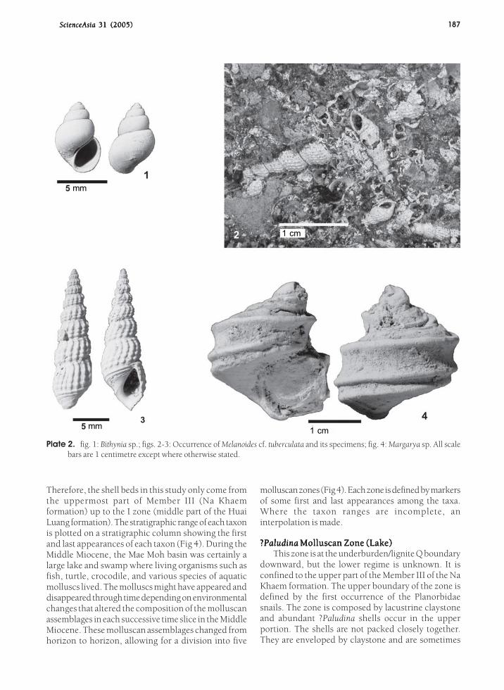
Plate 1. fig. 1: ?Paludina sp.; 2: ?Paludina sp.; figs. 3-4: Planorbidae gen. et sp. indet.; fig. 5: A corner of Bellamya bed exposedin the southwest margin of the coal pit; figs. 6-7: Bellamya sp. All scale bars are 1 centimetre except where otherwisestated.
ScienceAsia ScienceAsia ScienceAsia ScienceAsia ScienceAsia 31 (2005)31 (2005)31 (2005)31 (2005)31 (2005) 187
Plate 2. fig. 1: Bithynia sp.; figs. 2-3: Occurrence of Melanoides cf. tuberculata and its specimens; fig. 4: Margarya sp. All scalebars are 1 centimetre except where otherwise stated.
Therefore, the shell beds in this study only come fromthe uppermost part of Member III (Na Khaemformation) up to the I zone (middle part of the HuaiLuang formation). The stratigraphic range of each taxonis plotted on a stratigraphic column showing the firstand last appearances of each taxon (Fig 4). During theMiddle Miocene, the Mae Moh basin was certainly alarge lake and swamp where living organisms such asfish, turtle, crocodile, and various species of aquaticmolluscs lived. The molluscs might have appeared anddisappeared through time depending on environmentalchanges that altered the composition of the molluscanassemblages in each successive time slice in the MiddleMiocene. These molluscan assemblages changed fromhorizon to horizon, allowing for a division into five
molluscan zones (Fig 4). Each zone is defined by markersof some first and last appearances among the taxa.Where the taxon ranges are incomplete, aninterpolation is made.
?????PaludinaPaludinaPaludinaPaludinaPaludina Molluscan Zone (Lake) Molluscan Zone (Lake) Molluscan Zone (Lake) Molluscan Zone (Lake) Molluscan Zone (Lake)This zone is at the underburden/lignite Q boundary
downward, but the lower regime is unknown. It isconfined to the upper part of the Member III of the NaKhaem formation. The upper boundary of the zone isdefined by the first occurrence of the Planorbidaesnails. The zone is composed by lacustrine claystoneand abundant ?Paludina shells occur in the upperportion. The shells are not packed closely together.They are enveloped by claystone and are sometimes
mm 1 cm
1 cm
mm

188 ScienceAsia ScienceAsia ScienceAsia ScienceAsia ScienceAsia 31 (2005)31 (2005)31 (2005)31 (2005)31 (2005)
broken and flatten into formless shapes with about2-3 centimetres long, are difficult to be described andpositively identified (Plate 1, figs 1-2). Each shell bodyis separated from other closest shell bodies by about2-3 centimetres. Mae Moh lake was occupied by theseviviparous snails, ?Paludina, along a shallow shore inquiet conditions without any vegetation growing nearbyat this space and time.
Planorbidae Molluscan Zone (Swamp/Lake)Planorbidae Molluscan Zone (Swamp/Lake)Planorbidae Molluscan Zone (Swamp/Lake)Planorbidae Molluscan Zone (Swamp/Lake)Planorbidae Molluscan Zone (Swamp/Lake)The Planorbidae zone is located between the
underburden/lignite Q boundary and the K-4/K-3boundary. Even though there is no report on fossilmolluscs from the interburden and K-4 sub-zone, weregarded these portions as a part of the Planorbidaezone. We use the family name Planorbidae (wheel snail)rather than the genus name Planorbis used by theprevious study 1, because no good fossil specimens as
Planorbis have been found (Plate 1, figs 3-4). The shellPlanorbidae are the largest family of freshwater,pulmonate, and lung breathing gastropods. Livingspecies of Australian Planorbidae are found whereverthere are habitable waterbodies ranging from seasonalrain pools to large lakes.
The Planorbidae are common in some places in thelignite Q seam. This indicates that the fossil species ofPlanorbidae were living in a swamp environmentcontaining sparse to densely distributed vegetation.The interburden indicates that the basin was in a lakecycle without any vegetation.
BellamyaBellamyaBellamyaBellamyaBellamya-Planorbidae-?-Planorbidae-?-Planorbidae-?-Planorbidae-?-Planorbidae-?PaludinaPaludinaPaludinaPaludinaPaludina Molluscan Zone Molluscan Zone Molluscan Zone Molluscan Zone Molluscan Zone(Swamp/Shallow Lake)(Swamp/Shallow Lake)(Swamp/Shallow Lake)(Swamp/Shallow Lake)(Swamp/Shallow Lake)
This molluscan zone is confined within the K-3,K-2, and K-1 sub-zones, but the shell beds between theK-4 and K-3 sub-zones can also be regarded as a part
of this zone. The end of the previousmolluscan zone is defined by the very thinlignite layer, K-4, which is an indicative ofa swamp deposit. The overlying thickBellamya (Plate 1, fig 5) and ViviparidaeBeds are designated as the lowestoccurrence of this molluscan zone. TheViviparidae bed (Bellamya belongs toViviparidae) is widely distributed over themost of the basin, but the Bellamya bed isthe thickest layer, in the southwest marginof the coal pit. The uppermost part of theinterburden is in places overlain by the K-4 sub-zone and in the southwest marginof the coal pit, overlain by the Bellamyashell bed. The K-4 sub-zone is a thin coallayer that thins out in places. However, thecontact between either the interburdenand Bellamya bed or the lignite K-4 and theBellamya bed is sharp. No fossil molluscswere discovered from the interburden andthe K-4 sub-zone. At the lower boundary,the greenish gray interburden claystonegradually changes onward with moreorganic material contents like a peatformation and then the lignite K-4 on top.The Bellamya shell bed with sharp contactbetween the shell bed and the underlyingthe lignite K-4 and interburden claystoneresembles an erosional surface (Fig 5). Atthe upper boundary in contrast, theBellamya shell bed gradually changestowards the lignite K-3. Bellamya snailsdensely occur in the lowermost portion ofthe lignite K-3 and begin to graduallydisappear upward (Fig 6).
This widespread viviparous shell bed,
Fig 5.Lower boundary of the Bellamya shell bed showing environmentalchanges from lake, shallow lake, swamp, and then the one that formedthe Bellamya bed on top with a sharp contact.
Fig 6.Upper boundary of the Bellamya shell bed showing environmentalchanges from the Bellamya bed to swamp.

ScienceAsia ScienceAsia ScienceAsia ScienceAsia ScienceAsia 31 (2005)31 (2005)31 (2005)31 (2005)31 (2005) 189
with thickness ranging from 20-30 centimetres to nearly12 metres, occurs between the lignite bed K-4 and K-3. The shells of the Family Viviparidae, not identified inthe genus, generally occur in this horizon. Thecharacteristics of these shells are compared well withthe forms that occur from the Huai King formationexposed in the north of the pit. In the southwest marginof the coal pit, the twelve metre-thick Bellamya bed,covering an area of at least 70,000 square metres, isexposed. This freshwater mud snail, Bellamya (Plate 1,figs 6-7), dominates in dense aggregations almostwithout sediments as matrix, while in other places, theyare loosely cemented. They are accumulated under theconditions that formed alternations between layers ofentire snail shells and layers of densely fragmentedsnail shells. This clearly observable layering has a dipdirection of about 130º and dip angle of about 20º. Anisopach map (not shown in this paper) shows that thethickness variation of the shell bed looks like that of alens body, but actually the shell bed is bound by a setof faults. These Bellamya snails range in size from smalljuveniles of about 1 millimetre to adult of about 3centimetres. Many juveniles and their associatedopercula occur in inside of some female snail shells.However, a different taxon of tiny snails was also foundin the Bellamya Assemblage, namely a spire snail, Bithynia(Bithyniidae) (Plate II, fig 1). Since Bithynia is relativelysmall, about 5-7 millimetres, when compared withBellamya, Bithynia seems to be very rare in occurrence.
Molluscan assemblages between the K-4 and K-3sub-zones are dominated by freshwater viviparoussnails, including Bellamya, in the southwest, and byindeterminate viviparous snails in other places. Thetiny spire snail, Bithynia (Bithyniidae), which confirmsthe freshwater swamp depositional environ-ment,occurs at the same time. Remarkably, the Bellamya bedoccurs separated from the enclosing lignites, K-4 andK-3, whereas the Planorbidae occurs in the lignite K-3 and K-2 and ligneous claystone K-2 in some places.All taxa are missing from the ligneous claystone K-1. Toclarify this, from the sub-zones K-4 to K-1, theenvironment changed from a swamp to a shallow lakeand then to a deeper lake in the overburden claystone.These environmental changes had been probablycontrolled by the presence and absence of the molluscs,which each had a different environmental preference.
The specimens of the Family Planorbidae in thiszone occurred widely from both lignite and ligneousclaystone of the K-2 sub-zone. Whereas, ?Paludinaoccurs just from the ligneous claystone of the K-2 sub-zone in association with Planorbidae snails. Thisindicates that the specimens of Planorbidae preferredto inhabit in swamp with dense vegetation rather thanin lake with sparse vegetation but ?Paludina preferredto live in the lake with sparse vegetation. The ?Paludina
also preferred to live in a lake without vegetation asfound in the ?Paludina Zone.
MelanoidesMelanoidesMelanoidesMelanoidesMelanoides sp. cf. sp. cf. sp. cf. sp. cf. sp. cf. M. tuberculataM. tuberculataM. tuberculataM. tuberculataM. tuberculata Molluscan Zone Molluscan Zone Molluscan Zone Molluscan Zone Molluscan Zone(Lake)(Lake)(Lake)(Lake)(Lake)
The boundary of the K-1 sub-zone and theoverburden claystone is where these MalaysianTrumpet snails, Melanoides sp. cf. M. tuberculata (Plate2, figs 2-3), first appeared. This zone is a good lowerboundary of this acme zone. This zone covers theclaystone overburden and the lignite J. The lowerboundary of the zone is defined by the first appearanceof Melanoides sp. cf. M. tuberculata in association withabundant indeterminate viviparous snails, while theupper boundary is at the disappearance of Melanoidessp. cf. M. tuberculata. This molluscan zone is defined bylacustrine claystone indicating that the previous swampwas flooded, turning into a lake. Living Melanoidestuberculata is known to burrow through lake substratesby day and come out to feed at night. It is a carnivoroussnail living in freshwater environments near bank,avoiding stronger currents. This is why there is a highlikelihood of finding these snails in claystone ratherthan coal. At the same time, the indeterminate viviparoussnails had to survive in the same conditions withoutbeing able to burrow. This is a key to understandinghow the viviparous bed between the K-4 and K-3,including Bellamya bed, was preserved. It is highly likelythat sedimentation rates were low to allow this situationto occur.
MargaryaMargaryaMargaryaMargaryaMargarya Molluscan Zone (Local Swamp-Shallow Molluscan Zone (Local Swamp-Shallow Molluscan Zone (Local Swamp-Shallow Molluscan Zone (Local Swamp-Shallow Molluscan Zone (Local Swamp-ShallowLake)Lake)Lake)Lake)Lake)
A layer of the pond snail Margarya (Plate 2, fig 4)was discovered in the I zone of the Huai Luangformation. This layer is not uniform in lateral distributionand thickness forming a lensoid shape. The molluscsaggregated densely with a thickness about 50centimetres in some places, whereas in other places,they occur sparingly in dark gray sandy claystone witha thickness ranging from 1 to 2 metres. There is well-crystalline selenite, scattering in the red bed of sandyclaystone. The lignite I clearly indicates that this zoneis a local deposit as it is found in a lensoid shape.
INTERPRETATION, DISCUSSION AND CONCLUSION
The appearance range charts of molluscan taxaplotted against the lithostratigraphic unit clearlyindicate that paleoenvironmental changes led tocorresponding changes in rock type and their associatedmolluscan assemblages. Freshwater shells attributedto ?Paludina inhabited lakes beyond the shallow shorebut not the swamps. Shells of the Family Planorbidaepreferred to inhabit swamp and shallow lake, whereas

190 ScienceAsia ScienceAsia ScienceAsia ScienceAsia ScienceAsia 31 (2005)31 (2005)31 (2005)31 (2005)31 (2005)
Melanoides sp. cf. M. tuberculata inhabited areas beyondthe shallow shore on the lake substrate where therewas a lack of vegetation or only sparse vegetationgrowing.
Coexistence of the burrowing mollusc Melanoidessp. cf. M. tuberculata and non-burrowing indeterminateviviparous snails in the Melanoides sp. cf. M. tuberculatamolluscan Zone suggests that the depositionalenvironment of Bellamya bed is the same condition asMelanoides sp. cf. M. tuberculata. The alternation betweenlayers of entire snail shell bed and fragmented snailshell bed indicates that the Bellamya bed was formed bya dynamic sedimentary process rather than snails dyingand being deposited in situ. The snail shells may havebeen transported from just a short distance to the siteof deposition. The presence of brown stain on the shellregarded as original colour and well-preserved growthlines on the outside of shell surface is a good indicationfor the short distance transportation. The aggregationof complete shells without any sediment matrix indicatesthat either there was some water current action tocarry away the fine muddy sediments from the Bellamyashell deposit or that little or no sedimentation occurredat all at that time. The alternation of complete andfragmentary shell layer can probably also be interpretedas the result of water level changes in the Mae Moh lakeunder a desiccation regime. The possible erosionalsurface between the Bellamya bed and the underlyingsedimentary layer is a good evidence in term ofsedimentary process. It suggests that prior to depositionof the shell bed, the underlying lignite K-4 was partiallywiped out by some water current producing theerosional surface. After that Bellamya snails weretransported from somewhere to continuouslyaccumulate on the surface of erosion in successionforming the alternations between the entire snail shelllayers and the fragmented snail shell layers. Each cycleof the alternations of complete and fragmentary shelllayers may have occurred in the same episode of timebut the complete and fragmentary shells were separatedby different rate of deposition.
Margarya in the ligneous I zone is confined withina small local swamp in the red bed of the Huai Luangformation suggesting that Margarya occurred in asmall swamp probably in a flood plain environment.The selenite-bearing red bed sandy claystone isconsidered as secondary deposit sometimes after theHuai Luang formation was deposited. It is consideredthat the environment during the secondary depositwas arid condition. The hydrous calcium sulfatecrystals, CaSO
4.2H
2O, are said to be resulting from
solution cavities through precipitation of calciumsulfate-bearing groundwater that was saturated underan arid condition. The presence of selenite is in contrastto the massive gypsum that is more frequently
associated with evaporite deposits in playa in the aridenvironment which formed beds parallel to nearbysedimentary strata. But the selenite crystals from theHuai Luang formation are randomly scattered likenodules in red bed of sandy claystone without formingbeds. The gypsum crystals, selenite, and red bed weresecondarily formed by some proposed chemicalreactions such as the ones below:
CaCO3
CaO + CO2
(1)
4FeS2 + 11O
22Fe
2O
3 + 8SO
2(2)
CaO + SO3 + 2H
2O CaSO
4.2H
2O (3)
Source of calcium came from limestone (CaCO3) of
the Lampang Group that decayed to become lime (CaO).The lime reacted with sulfur trioxide (SO
3) (derived
from SO2) and water forming selenite crystals
(CaSO4.2H
2O) in saturated groundwater under an arid
environment. The pyrite (FeS2) was oxidised, producing
iron oxide (Fe2O
3) partially changing the colour of
original flood plain sediments into the red bed formationcontaining the selenite crystals. This is why the red bedformation still retains some original colour of greenishgray sandy claystone occurring in some places. Theligneous I zone with Margarya bed is still, however,preserved in the original colour of greenish grayclaystone lens, as this lens was under groundwatertable with low transmissibility, and thus oxidation andselenisation were not taken place.
All successions of the molluscan assemblagesthroughout the Mae Moh Group clearly indicate thatsedimentation in the Mae Moh Basin occurred infreshwater environments as the lake or swampalternations and ended up with a fluvial environment.Palynological assemblages indicate that there was amajor climatic change from a warm temperate climateto a tropical climate condition with evidence of exclusivefreshwater microscopic algae including Closterium andPediastrum as well as Cyperus, a taxon of sedge, growingwell in freshwater swamps. The Huai King formationwas possibly formed under a warm temperate climate.The Member III of the Na Khaem formation wasdeveloped under a transition between the warmtemperate and tropical climates. The rest of the NaKhaem formation onward (Member II and Member I)was deposited under a real tropical climate.8,9 The HuaiLuang formation was formed under fluvial deposits.The red colour of the Huai Luang formation is regardedas secondary alteration under an arid climate producingthe red bed formation containing abundant gypsumandselenite.
Molluscan assemblage successions in the Mae Moh

ScienceAsia ScienceAsia ScienceAsia ScienceAsia ScienceAsia 31 (2005)31 (2005)31 (2005)31 (2005)31 (2005) 191
basin form good stratigraphic markers. We can useeach taxon and its overlapping ranges to definestratigraphic levels within the Mae Moh basin.Correlation of these molluscan assemblages with otherbasins in the region of northern Thailand and elsewhereneeds further investigation.
ACKNOWLEDGEMENTS
We specially thank Mr. Somsak Potisat, DirectorGeneral of the Department of Mineral Resources, whohad a long vision in considering the thick shell bed siteas a national heritage and devotion in protecting thisshell bed as an important geological resource. We thankMrs. Benja Sektheera, Director of the Bureau ofGeological Survey, who provided us with many facilitiesduring field works and helped reviewing the draftmanuscript. The research would have been impossiblewithout the financial support from the Department ofMineral Resources. We sincerely thank all staffs of thecompany of Mae Moh mine, particularly Mr. PairoteAnupandhanant and Mr. Visut Bunthai, who providedus with much information and facilities during oursurveys of the coal mine. We thank Dr. Dallas Mildenhallof the Institute of Geological and Nuclear Sciences,New Zealand, who reviewed the draft manuscript andpointed out some errors with informative criticism toimprove this paper.
REFERENCES
1. Chaodamrong P (1985) Sedimentological studies of someTertiary deposits of Mae Moh Basin, Changwat Lampang. MasterThesis, Chulalongkorn University: 285 p.
2. Chaodamrong P and Burrett CF (1997) Stratigraphy of theLampang Group in central North Thailand: New version.CCOP Tech Bull 2626262626, 65-80.
3. Sasada M, Ratanasthien B and Soponpongpipat R (1987)New K/Ar ages from the Lampang Basalt, Northern Thailand.Geol Surv Jap Bull 38(1)38(1)38(1)38(1)38(1), 13-20.
4. Charoenprawat A, Chuaviroj S, Hinthong C andChonglakmani C (1995) Geological map of Thailand, sheetLampang (NE-47-7), scale 1: 250,000. Geol Surv Div, Dept MinRes, BKK, Thailand.
5. Benammi M, Urrutia-Fucugauchi J, Alva-Valdivia LM,Chaimanee Y, Triamwichanon S and Jaeger JJ (2002)Magnetostratigraphy of the Middle Miocene continentalsedimentary sequences of the Mae Moh Basin in northernThailand: Evidence for counterclockwise block rotation.Ear Planet Sc Let, 204204204204204, 373-83.
6. Von Koenigswald GHR (1959) A mastodon and other fossilmammals from Thailand. Roy Dept Mine, Thailand Rep Invest22222, 25-8.
7. Ginsburg L and Tassy P (1985) The fossil mammals and theage of the lignite beds in the intermontane basins of northernThailand. J Geol. Soc. Thailand 8(1-2)8(1-2)8(1-2)8(1-2)8(1-2), 13-27.
8. Watanasak W (1988) Mid-Tertiary palynology of onshore andoffshore Thailand. Doctoral Thesis, University of Adelaide, 1-207.
9. Songtham W (2003) Stratigraphic correlation of Tertiary Basinsin northern Thailand using algae pollen and spore. DoctoralThesis, Chiang Mai University, 1- 280.