
Middle Jurassic of western and northern Europe
14
61 Middle Jurassic sediments occur in almost all parts of what is conventionally drawn as the present-day con- tinent of Europe – from Portugal to the Caucasus, Sicily to Svalbard, the Hebrides to the Petshora – but in the context of the present book, we shall confine ourselves essentially to western and northern Europe, broadly from the Alps to the Arctic (Fig. 1). The shelf-seas of the Barents Shelf and Svalbard, also still part of Europe today, are not included, but the eastern shores of Greenland are. The palaeolatitudes in the Middle Jurassic were about 15º lower than they are today, so that Europe straddled the temperate zones from the sub-tropical to the sub-arctic. This is fully reflected both in the litho- and biofacies of the sediments, ranging from the pre- dominantly warm-water carbonates in the south, with their immensely diverse fossil biotas, to the siliciclastics with their impoverished fossil assemblages in the north. Historically, western Europe, as the cradle of geo- logical science together with its superbly developed Jurassic successions, has given us a longstanding knowl- The Middle Jurassic of western and northern Europe: its subdivisions, geochronology and correlations John H. Callomon The palaeogeographic settings of Denmark and East Greenland during the Middle Jurassic are outlined. They lay in the widespread epicontinental seas that covered much of Europe in the post-Triassic transgression. It was a period of continuing eustatic sea-level rise, with only distant connections to world oceans: to the Pacific, via the narrow Viking Straits between Greenland and Norway and hence the arctic Boreal Sea to the north; and to the subtropical Tethys, via some 1200 km of shelf-seas to the south. The sedimentary history of the region was strongly influenced by two factors: tectonism and climate. Two modes of tectonic movement governed basinal evolution: crustal extension lead- ing to subsidence through rifting, such as in the Viking and Central Grabens of the North Sea; and subcrustal thermal upwelling, leading to domal uplift and the partition of marine basins through emergent physical barriers, as exemplified by the Central North Sea Dome with its associated volcanics. The climatic gradient across the 30º of temperate latitude spanned by the European seas governed biotic diversity and biogeography, finding expression in rock-forming biogenic carbonates that dominate sediments in the south and give way to largely siliciclastic sediments in the north. Geochronology of unrivalled finesse is provided by standard chronostratigraphy based on the biostratigraphy of ammonites. The Middle Jurassic saw the onset of considerable bioprovincial endemisms in these guide-fossils, making it necessary to construct parallel standard zonations for Boreal, Subboreal or NW European and Submediterranean Provinces, of which the NW European zonation provides the primary international standard. The current versions of these zonations are presented and reviewed. Keywords: Northwest Europe, North Sea, East Greenland, Middle Jurassic, palaeogeography, geochronology, ammonite biostratigraphy, standard chronostratigraphy University College London, 20 Gordon Street, London WC1H 0AJ, UK. E-mail: [email protected] Geological Survey of Denmark and Greenland Bulletin 1, 61–73 (2003) © GEUS, 2003
Transcript of Middle Jurassic of western and northern Europe

61
Middle Jurassic sediments occur in almost all parts ofwhat is conventionally drawn as the present-day con-tinent of Europe – from Portugal to the Caucasus, Sicilyto Svalbard, the Hebrides to the Petshora – but in thecontext of the present book, we shall confine ourselvesessentially to western and northern Europe, broadlyfrom the Alps to the Arctic (Fig. 1). The shelf-seas ofthe Barents Shelf and Svalbard, also still part of Europetoday, are not included, but the eastern shores ofGreenland are. The palaeolatitudes in the Middle Jurassic
were about 15º lower than they are today, so that Europestraddled the temperate zones from the sub-tropical tothe sub-arctic. This is fully reflected both in the litho-and biofacies of the sediments, ranging from the pre-dominantly warm-water carbonates in the south, withtheir immensely diverse fossil biotas, to the siliciclasticswith their impoverished fossil assemblages in the north.
Historically, western Europe, as the cradle of geo-logical science together with its superbly developedJurassic successions, has given us a longstanding knowl-
The Middle Jurassic of western and northern Europe:its subdivisions, geochronology and correlations
John H. Callomon
The palaeogeographic settings of Denmark and East Greenland during the Middle Jurassic areoutlined. They lay in the widespread epicontinental seas that covered much of Europe in thepost-Triassic transgression. It was a period of continuing eustatic sea-level rise, with only distantconnections to world oceans: to the Pacific, via the narrow Viking Straits between Greenlandand Norway and hence the arctic Boreal Sea to the north; and to the subtropical Tethys, via some1200 km of shelf-seas to the south.
The sedimentary history of the region was strongly influenced by two factors: tectonism andclimate. Two modes of tectonic movement governed basinal evolution: crustal extension lead-ing to subsidence through rifting, such as in the Viking and Central Grabens of the North Sea;and subcrustal thermal upwelling, leading to domal uplift and the partition of marine basins throughemergent physical barriers, as exemplified by the Central North Sea Dome with its associatedvolcanics. The climatic gradient across the 30º of temperate latitude spanned by the Europeanseas governed biotic diversity and biogeography, finding expression in rock-forming biogeniccarbonates that dominate sediments in the south and give way to largely siliciclastic sedimentsin the north.
Geochronology of unrivalled finesse is provided by standard chronostratigraphy based on thebiostratigraphy of ammonites. The Middle Jurassic saw the onset of considerable bioprovincialendemisms in these guide-fossils, making it necessary to construct parallel standard zonationsfor Boreal, Subboreal or NW European and Submediterranean Provinces, of which the NWEuropean zonation provides the primary international standard. The current versions of thesezonations are presented and reviewed.
Keywords: Northwest Europe, North Sea, East Greenland, Middle Jurassic, palaeogeography, geochronology,
ammonite biostratigraphy, standard chronostratigraphy
University College London, 20 Gordon Street, London WC1H 0AJ, UK. E-mail: [email protected]
Geological Survey of Denmark and Greenland Bulletin 1, 61–73 (2003) © GEUS, 2003
62
TTTTT
TTTTT T T T T T T T T T T T T T T
T
T T T T T T T T T T T T T T T T T T T T T T T T T
TT
TTT T T T T T T T T T T
TT
TT
TT
TT
TT
T
T T T T T T T T T T T T T T T
TT
TTT T T T
Andøya
500 km
Viki
ng S
traits
Mar
ine
Bore
al Ba
thon
ian
Tethy
sMarine
Marine
SM
Ar
Deltaic
HRL
?
?
?
?
NB
Lu
Aq
?
Vo
He
Vi
HP
?
HI
Tr
211/21-1
NDB
SPVG
LBLCo
PB
Bo
Fr
Sw
MC
CNSDMo
CG
Callovia
n
BBaajjoocciiaann -- BBaatthhoonn iiaann
B ajocian–Bathonian
carbonates
JamesonLand
East Greenland
TTT
Land
Paralic/deltaic siliciclastics
Volcanics
Coastline probable
Coastline speculative
Facies boundary
Tethyan shelf edge
Extent of the CentralNorth Sea Dome
Well
50°
40°
30°
0° 10°10°
MNSH RFH
Skåne
9/10b-1

edge of that System unrivalled in detail. This is partic-ularly the case in the Middle Jurassic. It provides theprimary standard for comparisons with the rest of theworld. To this Denmark has contributed little, for itsJurassic lies almost wholly in the subsurface.
More recently, the post-war quest for petroleum hasopened up what had largely been an immense geologicalterra incognita, the circum-global Arctic. It quicklybecame apparent that the Middle Jurassic of the Arcticcould not be simply correlated with that of westernEurope because of non-overlapping endemisms in thedistributions of the critical geochronometers, here theammonites as guide-fossils. But at the same time, Danishgeological expeditions to East Greenland revealed thekey to correlations through the presence there of aresidual sedimentary and biostratigraphical record sogood that it has in turn become the chronostratigraph-ical standard for the whole of the Arctic. This gives theJurassic of East Greenland an importance out of all pro-portion to the modest extent of its outcrops.
The Middle Jurassic makes also an important con-tribution to another area of more recent geologicalexploration. It is that of the former shelf-seas whose sed-iments now lie under the North Sea and along the mar-gins of the southern North Atlantic, and whose interplayof tectonics and patterns of sedimentation form themajor topics in other papers of the present volume.Here, Denmark does play a significant role by virtueof its position between the centres of active rifting inthe North Sea and the passive littoral margins of the Balticcraton. The role of East Greenland is twofold. Firstly,it offers unique opportunities for direct study of fineexamples, now splendidly exhumed onshore, of thekind of structures and basin-fills widespread in the sub-
surface of the North Sea, important in the search forpetroleum but necessarily mapped largely by indirectgeophysical methods. Secondly, the biostratigraphy ofits ammonites provides the most precise available time-control on the genetic sedimentology and basin analy-sis, at a level of time-resolution that can significantlysteer the interpretations. This chronostratigraphy is out-lined here in some detail.
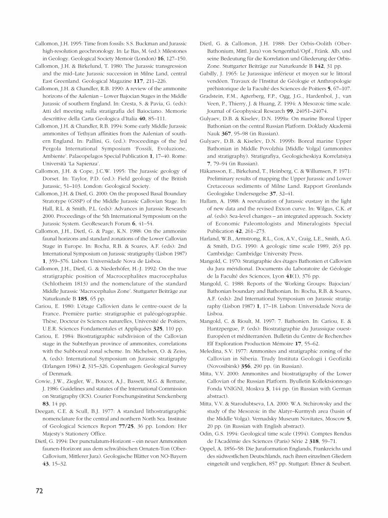
Palaeogeography, sedimentary basinsand tectonicsThe Middle Jurassic experienced a continuing first-orderworldwide (eustatic) rise in average sea level, reflectedin the transgressive sediments still preserved on almostall of the surviving palaeocratonic, peri-oceanic mar-gins of the former supercontinent Pangea. Taking themost optimistic estimate (see, for example, discussionby Hallam 1988) of, say, + 200 m for the Jurassic as awhole, this would suggest a mean value in the regionof 50–100 m for thicknesses of epicontinental marineMiddle Jurassic sediments that could be ascribed toeustatically-created accommodation space. One of themost plausible direct estimates to date (Sahagian et al.1996), based on the truly cratonic Russian Platform,gives about 30 m for the Bajocian–Callovian inclusive.Whatever the meaning of such a figure might be gen-erally, it does provide a yardstick when trying to esti-mate, or derive, the relative importance of theshorter-period, higher-order processes that modulatealmost all sedimentary successions more locally. Thisincludes the relative importance of higher-order eusta-tic fluctuations and regional tectonics in particular.
Palaeogeographically, the region around Denmarkduring the Jurassic lay still firmly inland on the Laurentiancraton (Fig. 1). The landscape was one of gently undu-lating post-Caledonian and post-Hercynian topographywhose highs had been eroded during the Carboniferousand Permian and whose lows had accumulated shal-low marine evaporites and lacustrine or fluviatile con-tinental sediments during the Triassic, a period ofhistorically low worldwide sea level. The marine trans-gressions marking the onset of a new major cycle ofeustatic sea-level rise at the beginning of the Jurassicthen flooded a vast peneplain and inaugurated theregime of very extensive, shallow epicontinental seasso characteristic of the Jurassic and Cretaceous, far dis-tant from the oceans and having few, if any, close cur-rent analogues. To the east lay the Eurasian continent,almost as large as it is today. To the north lay Fen-
63
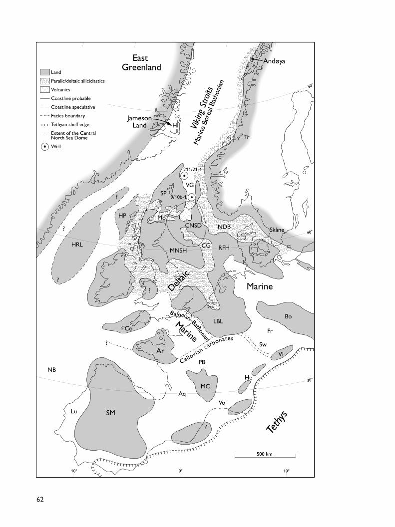
Facing page:Fig. 1. The palaeogeography of western Europe in the MiddleJurassic in early–mid Bathonian times. The dot-dashed linessouth of Ar–LBL represent the approximate northerly limits ofdominantly carbonate lithologies. The channel shown betweenGreenland and the Hatton–Rockall Landmass (the East Green-land Rift of Ziegler 1982) is highly conjectural. Aq, AquitaineBasin; Ar, Armorica; Bo, Bohemia; CNSD, Central North SeaDome; Co, Cornubia; Fr, Franconia; He, Helvetic highs (Aar,Gothard, Mt. Blanc massifs); HI, Hurry Inlet; HP, HebrideanPlatform; HRL, Hatton–Rockall Landmass; LBL, London–Brabant Landmass; Lu, Lusitanian basins; MC, Massif Central;MNSH, Mid North Sea High; Mo, Moray Firth basin; NB, New-foundland Banks; PB, Paris Basin; RFH, Ringkøbing–Fyn High;SM, Spanish Meseta; SP, Shetland Platform; Sw, Swabia; Tr, Trondheim Fjord; VG, Viking Graben; Vi, Vindelicia; Vo, Vocontian Trough.

noscandia, firmly emergent during the whole of theJurassic. To the west lay the shallow seas covering theNorth Sea, the British Isles and what are now the con-tinental shelves of the North Atlantic, with the NorthAmerican continent as far as Idaho and British Columbiabeyond. To the south lay the shallow basins of theEuropean platform, such the Anglo-Parisian, Aquitanian,Keltiberian, Rhodano-Helvetic, Franco-Swabian, LowerSaxonian and Polish Basins. The nearest ocean was theTethys, 1200 km to the south. Access to it was not unre-stricted but open through several broad channels. Theonly other access to the world’s oceans was north-wards, through the Viking Straits, another broad sea-way lying between Fennoscandian Norway andLaurentian Greenland (not the Viking Graben, a tectonicentity), connecting the central European seas with thoseof the Arctic and thence the Pacific.
A number of residual Hercynian rumps persisted asbasin highs or even islands during the Middle Jurassic.They include the Anglo-Brabant landmass (‘London–Ardennes Island’), the Scottish Highlands, Cornubia,Armorica, the Massif Central, the Harz (Hercynia),Bohemia and Silesia. None of these were large or highenough to be major passive sources of primary coarsesiliciclastic sediment, and although transgressive MiddleJurassic shoreline deposits may be observed at variousplaces on them, the extent of their proximal facies isusually rather local. The largest source of both coarseand fine siliciclastics must have been the Scandinaviancrystalline massifs to the north and east and, in theViking Straits, also Greenland. The coarser sedimentsnow occupy much of the shelves of the North Atlanticand a broad belt extending from the northern North Seaover Denmark into the Baltic. The finer sediments werevery widely dispersed and the predominant facies ofthe European Middle Jurassic – the Brown Jura – northof the carbonate belts are clays, silts and fine-grainedsands. Supply in most cases kept up with demand andeven in troughs created by local subsidence (see below),water depths stayed more or less constant. The epi-continental European seas were shallow, perhaps in therange 0–100 m, and quite small oscillations of relativesea level could produce transgressions and regressionsover great distances. The positions of former shorelinesare therefore often more than usually elusive.
This general first-order picture was however widelydisrupted by tectonic movements. The break-up of Pangeahad commenced and by the Middle Jurassic, Gondwanahad parted from Laurasia. The North Atlantic remainedclosed, but the Central Atlantic had opened and WestAfrica was now separated from Appalachian America by
1000 km of ocean. The effects of these major continen-tal movements were clearly not localised in the Tethysbut felt also further north. One widespread expressionwas in the form of rifting into horst and graben or half-graben structures. Thus, the Vocontian Trough in south-ern France contains up to 750 m of Middle Jurassicsediments (Terres noires); the Lusitanian Basin off west-ern Portugal up to 700 m; the Central Graben of theNorth Sea, up to 1000 m; the Viking Graben of the north-ern North Sea, up to 250 m; and the basins of the VikingStraits whose fill is now preserved onshore in EastGreenland, up to 700 m. These were correlated majorperturbations extending over 2000 km on a single plate.
Extensional rifting was complemented by other per-turbations of a different character: a transient regionaluplift centred in the Central North Sea (Ziegler 1982),driven by thermal upwelling of a subcrustal plume andfollowed by its dissipation and subsidence. The historyof this event has been recently described in consider-able detail by Underhill & Partington (1993, 1994). Therise of the dome began in the late Early Jurassic(Toarcian). It broke marine surface in the Aalenian withthe onset of erosion, providing a new source of sedi-ment for its surrounding basins. It culminated with theeffusion at its centre of a thick lava pile up to 1500 mthick, probably during the Bathonian–Callovian.Formerly termed the Rattray Formation (Deegan & Scull1977), these Middle Jurassic volcanics have been rede-fined as the Rattray Volcanics Member and the RonVolcanics Member, both of the Pentland Formation(Richards et al. 1993). Deflationary subsidence witherosional peneplanation was substantially complete inthe Late Oxfordian and was followed by marine trans-gression. The differential uplift of the central dome isestimated to have been (at least) 400–500 m. The wholecycle of topographic uplift and subsidence had a periodof 40 Ma, but its highest point lay in the Middle Jurassic.Its palaeogeographic effects extended over an areamore than 1200 km across, from the East ShetlandPlatform in the north to the Scottish Highlands andYorkshire in the west, to the London–Brabant Massif inthe south and the Ringkøbing–Fyn High in the east andtaking in the Mid North Sea High – covering in fact almostthe whole of the North Sea. Movements were morelikely to have been pulsed than steady, both of dom-ing and of rifting. Their sedimentary expressions couldtherefore well have been at least partly time-correlatedacross the region and given rise to widely recognisablesuccessions of sequences and systems tracts. But withsuch a strong tectonic overprint, both of doming andof rifting, claims to be able successfully to identify an
64
underlying higher-order eustatic cyclicity in the MiddleJurassic of the North Sea seem somewhat improbable.
Palaeolatitude, climatology and bioprovincialism The shelf-seas of the European Middle Jurassic ranged inlatitudes from about palaeolatitude 28°N (henceforth abbre-viated to p-48°) in the south, at the northern margins ofthe Tethys, to about p-48°N at, say, central East Greenland(Smith et al. 1981). The climatic gradient is clearly evidentin sedimentary facies. In the south, carbonates dominate,such as lime mudstones and skeletal grainstones, includ-ing coarse echinoderm ‘breccias’. There are widely devel-oped carbonate platforms and ramps. In the north,carbonates are rare or absent and never rock-forming.The pattern between these extremes is complex. It wasevidently determined by an interplay of current patternsand topography, which strongly influenced the distribu-tion of both benthic and nektoplanktonic biotas. Thus, forinstance, the eastern Paris Basin, the Jura and what arenow the Helvetic Alps (p-32°N) saw the build-up of arange of thick bioclastic carbonate platforms in theBajocian–Bathonian. These shielded the Swabo-FranconianBasin lying behind them from Tethyan influence on its west-ern side, its southern and eastern sides being boundedby the Vindelician and Bohemian massifs. The contrastbetween the Paris and Swabo-Franconian Basins, lying atsimilar palaeolatitudes, could therefore hardly be greater,the former abounding in a rich and highly diverse warm-water fossil biota; the latter, a sediment-starved basin witha highly impoverished fauna and almost no carbonates.Further north-west, the warm-water carbonates and theirrich biotas, with corals, reached the Cotswolds of England(p-37°N), whereas the Middle Jurassic of northern Germanyat the same latitude was almost as impoverished as thatof Franconia. The furthest north that Tethyan warm-waterinfluences are detected is Scoresby Sund, East Greenland(p-48°N), where Bathonian hermatypic corals have beenfound very close to the transgressive western shoreline ofthe Viking Straits (Håkansson et al. 1971; Callomon &Birkelund 1980).
Of immediate concern is the influence of the factorsoutlined above on the distribution of one group oforganisms, the ammonites, for these are the leadingguide-fossils whose biostratigraphy provides the pri-mary standard chronostratigraphy over the whole region.The Middle Jurassic saw a strong segregation of theammonites into three faunal provinces. These occupysuccessive, broadly latitudinal belts.
The most southerly belt lies along the northern mar-gins of the Tethys, including Iberia (but not the Beticand Subbetic basins of Andalucia), Aquitaine, the south-ern Paris Basin, the southern Jura, peri-CarpathianPoland and much of the Balkans. It is usually referredto as the Submediterranean Province of the TethyanRealm. Its ammonite faunas are rich, diverse and char-acteristic of warm-water, shallow neritic shelf-seas. Theydiffer from those of the Tethyan Province proper mainlyin compositions, which are reflections of different bio-ecological habitats. The true Tethyan faunas are madeup predominantly of pelagic groups such as Phyllocerasand Lytoceras and are found in the pelagic carbonatesof former seamounts and carbonate platforms still pre-served, for example, in Andalucia, Sicily, the Apennines,the Venetian and Austrian Alps and the southern Balkans.Their places of entombment were not necessarily indeep water – some of them accumulated cross-beddedoolites – although their living habitats almost certainlywere. They do occasionally mingle with the faunas ofthe shelf-seas, but then invariably as rare stragglers.
The next belt constitutes the Subboreal Province ofthe Boreal Realm. It extended from the Scottish High-lands in the north (p-42°N) across northern Europe(southern England, Normandy, Boulonnais, Germanyand the northern Jura, northern and central Poland)into the Moscow–Volga–Donets Basins on the RussianPlatform, across the northern Caucasus into trans-CaspianTurkmenistan and the basins of the Amudarya, northof Afghanistan, before now being lost under theHimalayan ranges of the Pamirs. In the Aalenian,Bajocian and Bathonian, the distinction between Sub-mediterranean and Subboreal faunas lies almost whollyin their diversities rather than in their mutually exclu-sive distributions. The provinces are therefore rarelyexplicitly differentiated in these Stages and their fau-nas usually referred to simply as ‘European’. The diver-sity-differentiation is however already clearly discerniblein the Aalenian, during which typically Submediterraneanfamilies reached Dorset in abundance (Callomon &Chandler 1994) while being virtually unknown in Swabiaand Franconia. The Subboreal Province became clearlydifferentiated from the Submediterranean Province onlyin the later Middle Jurassic, the Callovian. It was char-acterised mainly by two families, the Cardioceratidaeand Kosmoceratidae, whose distributions were comple-mentary to those of the Submediterranean Reineckeiidaeand Oppeliidae. The boundaries could be sharp, as ingoing from southern Normandy into Touraine and Poitou,or very diffuse, with much overlap, as in Germany.
65
The third, most northerly, belt constitutes the BorealProvince of the Boreal Realm. It existed sporadicallyalready in the Toarcian and Aalenian, but became clearlyand strongly differentiated in the late Early and earlyLate Bajocian. It then persisted into the Cretaceous. Itoccupied the shelf-seas of the Arctic (there being nopositive evidence of the existence at that time of a trulyoceanic Arctic Ocean), from the Alaskan North Slopethrough the Yukon over the Canadian Arctic Archipelagointo Svalbard and the whole of the Barents Sea includ-ing Franz Josef Land, Novaya Zemlya and the PetshoraBasin, the Laptyev Sea and Kheta and Lena Basins innorth-central Siberia, and thence into north-easternSiberia and back to the Bering Straits. During the MiddleJurassic this sea, forming a rough triangle of sides 5000km, was largely land-locked on two sides, by Laurentiaand Eurasia (see map in Callomon 1985, text-fig. 6a).Communication in the early Middle Jurassic with the restof the world’s oceans was possible in only two areas.The first was through a series of gateways into thenorthern Pacific, between Kolyma in far-eastern Siberiaand eastern Alaska (although an anywhere near pre-cise knowledge of where these gateways lay must awaita satisfactory plate-tectonic reconstruction of this wholeregion). The second was the relatively narrow channelof the Viking Straits leading southwards to the epicon-tinental seas of Europe and thence to the Tethys. Athird route opened in the late Middle Jurassic, in theCallovian, when marine transgression from the Petshoraacross the Russian Platform finally inundated theMoscow–Volga Basins and thence completed the con-nections with the European epeiric seas from the east.
The connecting route of particular interest here is theone between Laurentia and Fennoscandia along theViking Straits. The largely landlocked Middle Jurassicseas of the Arctic developed their own endemic faunasof ammonites, which lived and evolved there in almosttotal isolation from those further south. They did how-ever venture down the Viking Straits as far as theShetland Islands. Here the seas divided into two chan-nels (Fig. 1). The westerly one passed southwards tothe west of Ireland, along the Faroe–Rockall troughs andperhaps others even further west, and gave connectionswith the western Tethys presumably via the Lusitanianseas west of Iberia. Little detail is so far known aboutthe Middle Jurassic history of these channels. The east-erly channel passed to the east of the Shetlands in thegeneral direction of the North Sea and its sediments arepreserved and well-documented in the Viking Graben,particularly in the Brent Field (Deegan & Scull 1977;Underhill & Partington 1993). The most southerly point
from which fully marine Boreal Bathonian sedimentswith ammonites have so far been described appears tobe at Total’s well 9/10b-1 (Bruce Field, 59°40´N, p-44°N; Callomon 1979), 170 km ESE of Lerwick in theShetlands. Progress further southwards into the NorthSea was then blocked by the emergent Central NorthSea Dome. Its western non-marine flanking sedimentshave long been recognised in the various ‘EstuarineSeries’ found in the Aalenian–Bathonian Middle Jurassicof Britain, from Scotland to the eastern Midlands. Marineconnections between the northern North Sea and thenormal marine seas of Wessex, and the north Germanand Polish basins were completely cut by a physical bar-rier. No Middle Jurassic ammonites have been recordedfrom Denmark, although typical European faunas areagain well-represented in the southern Baltic (Stoll1934). The ammonite faunas of the Boreal and EuropeanProvinces were wholly segregated: no region of over-lap is known. Both faunas evolved independently andprovide the biochronologies on which the standardchronozonations are based. This means, however, thatthese chronozonations have had to be worked out inde-pendently, one standard scale for each Province (seebelow), and correlations between these provincial scalescontinue to range from problematic to impossible. Ofparticular interest here is the fact that the most detailedbiochronology of the Boreal Bajocian–Bathonianammonites anywhere in the Arctic has been thatrecorded in central East Greenland, through an unusu-ally favourable combination of circumstances (Callomon1993). It provides currently the chronostratigraphic stan-dard of reference for the whole of the Arctic.
What of the channels to the west of Ireland? NoBoreal Middle Jurassic ammonites have so far beenfound anywhere along their former courses, althoughthis may be due wholly to lack of outcrop or samplingin boreholes. Certainly no ammonites penetrated as farsouth as the Lusitanian basins (p-30°N). Yet that theremust have been a fully marine connection is attestedby those hermatypic corals found in Milne Land, EastGreenland: they could have got there by no other route.The failure of the ammonites to migrate southwardstherefore probably reflects an ecological barrier: a caseperhaps of inability to migrate against a northerly-flow-ing warm-water current carrying an inimical food-chain.
Direct marine connections between the Arctic andEurope were restored in the Early Callovian. A secondBoreal family of ammonites, the Kosmoceratidae, alsowith a long pre-Callovian history in the Arctic, sud-denly appeared in Europe. But whether the connectionwas via the Viking Straits or via the Russian Platform
66
was until recently not clear: new discoveries now makethe latter the more probable (Gulyaev & Kiselev 1999a,b; Mitta 2000; Mitta & Starodubtseva 2000). The earli-est, a Kepplerites, has been found in the Upper Bathonianof Franconia (Dietl & Callomon 1988). It resembles aform from the lower Calyx Zone of East Greenland (seebelow), also of Late Bathonian age. The first horizonwith abundant Kepplerites keppleri (Oppel) has beentraced from southern England (Upper Cornbrash) vianorthern and southern Germany to the northern Juraand probably as far as the Caucasus. It marks the baseof the Callovian Stage and also has close relatives inEast Greenland. It is closely followed by the earliest hori-zon with abundant Cadoceras of the Cardioceratidae,also traceable from Dorset via Germany to the north-ern Jura, with now closely related forms all over theRussian Platform (Cadoceras elatmae (Nikitin)). Yet theearliest known ammonites from marine sedimentsdirectly overlying non-marine deltaic facies in Scotlandcame from considerably higher levels, in the earlyKoenigi Zone on the east coast (Moray Firth) and in thelate Koenigi Zone on the west coast (Skye). Furthermore,no Callovian ammonites have been recorded from any-where in the central North Sea. Indisputably directmarine connections between the Arctic seas and thoseof Europe via the Viking Straits were however fully re-established in the Late Callovian (Athleta Zone). Thesame standard zonation can be applied to sedimentsfrom the top of the Lower Callovian upwards in boththe Viking Straits as preserved in East Greenland andthroughout northern Europe (see below).
Standard zonal chronostratigraphyThe Middle Jurassic is made up chronostratigraphicallyof four standard Stages: Aalenian (lowermost, Aalen,south-west Germany), Bajocian (Bayeux, Normandy),Bathonian (Bath, England) and Callovian (uppermost,Kellaways, Wiltshire, England) (Fig. 2). The chrono-metric ages of its boundaries are not directly very closelydetermined, but recent reviews (Harland et al. 1990;Odin 1994; Gradstein et al. 1994) are in tolerable agree-ment in assigning to the Middle Jurassic a duration of21 Ma, i.e. close to a third of the 62–68 Ma of the Jurassicas a whole. Published chronometric ages for individualStage boundaries are largely based on non-chronomet-ric estimates of their relative durations, such as the num-ber of standard chronostratigraphic Zones or Subzonesthey (now) contain, and should be treated with corre-sponding caution (see Pálfy 1995; Pálfy et al. 2000).
The standard Zones and Subzones used here arechronozones defined by their bounding time-planesand are at the lowest two levels (VI and VII) of a hier-archy of successively finer subdivisions of the geolog-ical column, of the Jurassic System (III), its Series (IV)and Stages (V) (Callomon 1994, 1995). The observationalbasis is the biostratigraphy of the most sensitively time-diagnostic guide-fossils available, here the ammonites,which serve to characterise the Zones in terms of theircontents and to correlate successions. In most cases evenfiner time-resolutions are possible within a Subzone,based on the recognition in it of more than one distin-guishable – in an evolutionary sense – biohorizon, whosenumber can increase with the growth of knowledge ofa highly incomplete geological record (Callomon 1995).
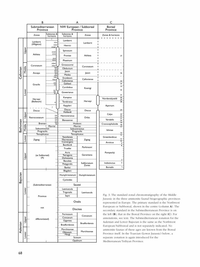
Figure 3 shows standard zonations for the threeammonite biogeographic provinces represented in west-ern Europe. Such zonations grow with time and knowl-edge. The oldest, going back substantially to Oppel(1856–58) is that covering the Northwest European orSubboreal Province, in which lie most of the outcropsstudied during the classical age of geology (column A).It is the best known and most complete and hence pro-vides the primary standard. The zonation used todayin the Submediterranean Province is shown alongsideit at the left (column B). Its Bathonian part becameestablished in the 1940–50s, its Callovian part a little later.The Boreal zonation shown in the column at the right(C) was wholly unknown before 1959.
The purpose of diagrams such as these is to repre-sent what are effectively relative time-scales. But asthere are no independent ways of estimating the rela-tive durations of the time-periods represented by Zones
67
Oxfordian
StagesSeries
Callovian
Bathonian
Bajocian
Aalenian
Toarcian
Middle
Jurassic
(Dogger)
Fig. 2. The primary standard Stages of the Middle Jurassic.
68
Upp
erM
iddl
eLo
wer
Upp
erM
iddl
eLo
wer
Upp
er
Bath
onia
nC
allo
vian
Morrisi
37
36
35
33
32
31
34
302928
24
23222120191817
1413
1110 9 8
3
2
1
?
?
Zones Zones & horizonsZones
Lamberti
Athleta
Coronatum
Jason
Orbis
Zigzag
Parkinsoni
Garantiana
SubfurcatumZones
Calloviense
Koenigi
Herveyi
Discus
Nordenskjoeldi
Apertum
Calyx
Variabile
Cranocephaloide
Ishmae
Greenlandicus
Arcticus
Pompeckji
Indistinctus
Borealis
Lamberti(Alligatus)
Athleta
Coronatum
Anceps
Gracilis
Herveyi(Bullatum)
Discus
Retrocostatum
Zigzag
Bremeri
SubcontractusProgracilis
Tenuiplicatus
(as Subboreal)(A)
Banksi
PolygyralisBaculata
DichotomaTetragona
Acris
Truellei
BomfordiConvergensMacrescensYeovilensis
TenuiplicatusProgracilis
SubcontractusMorrisiHodsoni
Blanazense
Hannoveranus
HollandiDiscus
Keppleri
Terebratus
Kamptus
Gowerianus
Curtilobus
GalilaeiiCallovienseEnodatum
Medea
JasonObductum
Grossouvrei
Phaeinum
Proniae
Spinosum
Henrici
Lamberti
Subzones &horizons
Subzones &horizons
BorealProvince
NW European / SubborealProvince
SubmediterraneanProvince
B A C
XX•XIX•
XVIII•
XVII•XVI•
XV•XIV•
XIIIb•XIIIa•
XII•XI•Xb•Xa•IX•
VIII•VIIb•
VIIa•VI•V•
IV•III•II•
I•
14•13•12•11•10•9•
Bajo
cian
Low
er
Aal
enia
nLo
wer
Upp
er
(Submediterranean
Province
not
differentiated)Concavum
Bradfordensis
Murchisonae
Discites
Ovalis
Sauzei
Humphriesianum
Laeviuscula
FormosumConcavumGigantea
Bradfordensis
MurchisonaeObtusum
Haugi
SayniTrigonalis
Laeviuscula
Cycloides
Humphriesianum
Blagdeni
ScissumOpalinum
Fig. 3. The standard zonal chronostratigraphy of the MiddleJurassic in the three ammonite faunal biogeographic provincesrepresented in Europe. The primary standard is the NorthwestEuropean or Subboreal, shown in the centre (column A). Thesecondary standard in the Submediterranean Province is onthe left (B), that in the Boreal Province on the right (C). Forannotations, see text. The Submediterranean zonation for theAalenian and Lower Bajocian is the same as the NorthwestEuropean/Subboreal and is not separately indicated. Noammonite faunas of these ages are known from the BorealProvince itself. In the Toarcian (Lower Jurassic) below, aseparate zonation is again introduced for theMediterranean/Tethyan Province.
or Subzones, there is no unique or permanent way ofdrawing the diagrams. The scheme adopted here is toassume that the time-intervals between adjacent dis-tinguishable ammonite biohorizons in the primary stan-dard (A) are equal. As they are the smallest time-intervalsat present resolvable by means of ammonites, the errorsin this assumption are likely to have the least effect onthe implied relative durations of the coarser units, theZones and Subzones. The known number of such resolv-able biohorizons is of course not final either. But as theEuropean standard has been worked on intensively overa long time, it is safe to say that in the Middle Jurassicat least, we are now close to what is achievable in time-resolution by means of ammonites. Taking the esti-mates of duration of the Middle Jurassic quoted at thebeginning, of 21 (± 4?) Ma, the average time-intervalbetween faunal horizons (115) is 180 (± 36) ka; the aver-age duration of a standard Zone (28) is 750 (± 150) ka.
Correlation between European Subboreal andSubmediterranean scales (A–B) is sufficiently close todraw them on the same scale. Correlation between theEuropean and Boreal scales (A–C) even at Zonal levelis so imprecisely known that they have to be drawn quiteindependently. It is however probable that the lowest,Borealis Zone correlates with levels at around theLower–Upper Bajocian boundary. Such a correlationhad been previously postulated on the basis of a chainof correlations via the North American Cordillera(Callomon 1985, p. 64). It has now been confirmedthrough measurements of the stable isotopic ratio ofstrontium (87Sr/86Sr) in belemnites (J.H. Callomon, unpub-lished data; M. Engkilde, personal communication 1997).Scale C is therefore also drawn on a faunal-horizonequal-interval assumption, based on the best availableammonite biochronology of East Greenland. The Borealintervals have, however, been stretched somewhat rel-ative to those of the European standard, to take theBorealis Zone down to the early Upper Bajocian.
A: European Subboreal primary standardThe names of both Zones and Subzones as currentlyin use have been written out. To complete their defin-itions, the bounding time-planes of these standardchronostratigraphic units have to be fixed in boundarystratotype sections. While such definitions have beenproposed for many of the Zones and Subzones, nonehave so far been formally ratified by the InternationalCommission on Stratigraphy, whose aspirations do notcurrently descend below the level of standard Stages
(Cowie et al. 1986). The lack of such formal definitionsappears to have remarkably little consequence in prac-tical day-to-day affairs. The reason has been pointedout repeatedly (Callomon 1995) and is important. It isthat rocks are correlated by means of the contents ofZones – what lies between the bounding time-planes– rather than by correlation of the time-planes them-selves. The wide variations in the relative time-valuesand numbers of Subzones in Zones as shown in the col-umn are almost entirely of historical origin, reflectinga compromise between the growth of knowledge (fau-nal horizons) and a desire to retain some stability in zonalnomenclature. (In the times of Oppel (1856–58) and ofWaagen (1867), the number of Zones in what is today’sMiddle Jurassic was 13; in Arkell’s review of 1956 itwas 21; here it has grown to 28).
Aalenian–Bajocian
Based on recent revisions (Callomon & Chandler 1990;Callomon 1995; Callomon & Cope 1995).
Bathonian
The chronostratigraphy of this Stage was one of the lastto be worked out in Europe because of exceptionallydifficult ammonite biostratigraphy – scattered part-sec-tions with only sparse ammonites. The first compre-hensive modern syntheses by Gabilly (1965) and Mangold(1970) were based on the successions in western andeastern France, respectively. A review by Westermann& Callomon (1988) of its faunal successions was givenin terms of 16 faunal horizons, some of which (9–14)are numbered here. Some subsequent refinements in theUpper Bathonian of Swabia were reported by Dietl &Callomon (1988), and a discrepancy between the Middleand Upper Bathonian boundaries as drawn in theNorthwest European and Submediterranean classifica-tions was resolved by Mangold (1988). The most recentreviews, by Callomon & Cope (1995, p.73) and Mangold& Rioult (1997), differ in some details of nomenclaturebut retain essentially the same biostratigraphic basis offaunal horizons. Thus horizon 11, of Procerites querci-nus, is elevated into a Quercinus Subzone of theNorthwest European Hodsoni Zone, thereby raising thebase of the Orbis Zone by one horizon; and theConvergens and Yeovilensis Subzones of the ZigzagZone are given separate names in the SubmediterraneanProvince. The historically-conditioned difference between
69

the numbers of faunal horizons in the Lower–Middle andUpper Bathonian respectively is here particularly marked.
Callovian
Much new information in recent years has greatly ampli-fied our knowledge of the Lower and Upper parts ofthe Stage. The former was revised by Callomon et al.(1988) and Page (1989), the latter by Dietl (1994 andunpublished data, based on excavations in Swabia) andCallomon & Cope (1995). The Herveyi Zone is the for-mer Macrocephalus Zone renamed, after it was dis-covered that the type-horizon of the index Macro-cephalites macrocephalus (Schlotheim) did not in factlie in its eponymous Zone (Callomon et al. 1992). A sim-ilar change of index will have to be made for theSpinosum Subzone of the Athleta Zone, because thetype-horizon of Kosmoceras spinosum (J. de C. Sowerby)is now known to lie in the Lamberti Zone. Only theCoronatum Zone remains in need of a modern revision.The Middle–Upper Callovian boundary as reproducedhere was defined in terms of the phyletic transients ofthe lineage of Kosmoceras in England (Callomon 1964,1968) and not on the first appearance of Peltoceras,which came in a little later. The upper boundary of theCallovian Stage, and hence the Middle–Upper Jurassicboundary, has always been taken biostratigraphicallyto lie between the highest known faunal horizon of theLamberti Zone, that of Quenstedtoceras paucicostatumLange, and the lowest horizon of the Oxfordian MariaeZone, that of Q. woodhamense Arkell. It was usuallyeasy to recognise because over large parts of NorthwestEurope it is marked by a non-sequence. The discoveryof expanded sequences across the boundary, e.g. inDorset and southern France, has made the final choiceof stratotype section a matter of current debate.
B: Submediterranean secondary standard
Aalenian–Bajocian
The Northwest European zonation is applicable andno separate scheme has been introduced.
Bathonian
Also reviewed by Westerman & Callomon (1988) andMangold & Rioult (1997). The Northwest European
zonation is used for the Lower and all but the topmostMiddle Bathonian. Differentiation became marked onlyin the Upper Bathonian. The Submediterranean suc-cession was worked out mainly in France, particularlyin Poitou (Gabilly 1965), the southern Paris Basin andthe southern Jura (Mangold 1970). There its uppermostpart appears to be marked also by a widespread faunalor stratigraphical non-sequence, so that the Bathonian–Callovian boundary was until recently not clearly char-acterised (see below).
Callovian
Based predominantly on the faunal succession in west-ern France worked out by Cariou (1980, 1984). Hislabelling of faunal horizons (I–XX) has been includedhere, although the names of the Subzones, many ofwhich contain only a single faunal horizon, have beenomitted. Both bottom and top of the succession aremarked by regionally widespread gaps. Since Figure 3was drawn, however, a newly discovered section atBuffevent, near Niort in Poitou, shows an expanded suc-cession that spans the Bathonian–Callovian boundary(B. Balusseau, P. Branger and E. Cariou, personal com-munications 2000). Most particularly, one of its beds hasyielded Kepplerites keppleri, characteristic of the basalfaunal horizon of the Callovian Stage by definition(Callomon & Dietl 2000). The bases of the CallovianStages in both primary NW European (A) and secondarySubmediterranean (B) classifications can therefore betaken to coincide exactly.
There remain some nomenclatural inconsistenciesto be resolved, in that while some of the Zones, e.g.Gracilis and Anceps, are named after distinct Sub-mediterranean indices, others, such as Coronatum andAthleta, share their names with their counterparts inthe primary standard (A). Yet these Zones are inde-pendently defined and are of slightly different extents.The Submediterranean Athleta Zone, for instance, hasbeen chosen to begin at the first appearance of Peltocerasin the Hecticoceras trezeense horizon, XV, which lies ata level near the top of the Phaeinum Subzone of theprimary Athleta Zone. The lowest Callovian Zone hadfor a long time been given a separate name and iden-tity, the Bullatum Zone, as neither its base nor its topcould be closely correlated with the primary standard.Precise correlation of its base has now been achieved(see above) and so the main obstacle overcome. It hastherefore been entered in Figure 3 also under the nameof the primary index as Herveyi Zone (olim Macro-
70

cephalus). As its top, the base of the overlying GracilisZone, continues to be independently defined, it may bemore appropriate, however, to continue to follow Frenchusage (Thierry et al. 1997) and to retain the BullatumZone in the Submediterranean classification. An analo-gous alternative for the name of the top Callovian Zonein the Submediterranean Province, instead of Lamberti,would be [Perisphinctes] Alligatus Zone.
C: Boreal secondary standardThis was recently reviewed by Callomon (1993), basedon the ammonite succession in East Greenland. Almostno ammonite faunas of Aalenian – Early Bajocian ageshave been recorded anywhere in the European Arctic,and in much of the region the record of this period ismarked either by stratigraphical gaps, or unfossilifer-ous or non-marine deposits (Smelror 1994). In EastGreenland, the youngest ammonite faunas known frombelow the Borealis Zone are of Early Toarcian age(Pseudolioceras lythense, Bifrons Zone). In Svalbardand the Barents Shelf, the same is probably true, forclaims to have recognized earliest Aalenian ammonites,associated with Toarcian forms, in a remanié con-glomerate, the Brentskardhaugen Bed (Wierzbowski etal. 1981), are based almost certainly on misidentifica-tions as close Aalenian homoeomorphs of the olderToarcian species.
The Borealis Zone is clearly recognisable through-out the whole of the Arctic and is now known to cor-relate with the lower Upper Bajocian of Europe or levelseven a little older (see general discussion above).Thereafter, the faunal horizons are numbered 1–35 upto the top of the Lower Callovian, as in Callomon (1993),with a few subsequent additions based on recent unpub-lished field observations. They form the basis of theBoreal zonation. Zones have so far not been subdi-vided, and their different relative durations also reflectthe historical evolution of knowledge. In the Middle andUpper Callovian of East Greenland, ammonites are sosparse (although the succession is thick) that they con-tribute nothing further to standard chronostratigraphy.Elsewhere, for example in arctic Russia and Siberia, theUpper Callovian is divided into a lower Zone of Longae-viceras keyserlingi and an upper Zone of Eboracicerassubordinarium (Meledina 1977), but the ammonitebiostratigraphy is so fragmentary that they have notbeen included here.
ConclusionThe Middle Jurassic of those parts of Europe under dis-cussion in this volume encompasses a highly diverserange of tectonic, sedimentary and palaeobiotic devel-opments. To unravel their evolution successfully callsfor the closest possible time-control of the rocks: oftime-correlations over distances and of time-resolutionmore locally. Fortunately, such time-control is providedby an abundance of good guide-fossils, the ammonites,whose biostratigraphy has given us a chronostratigraphiccalendar of unrivalled finesse and hence, conversely,the clocks for dating individual rocks with great preci-sion. The construction of the calendar has taken mucheffort over many years in many countries and the cal-endar that has emerged may seem complicated. Butthe rewards justify the effort needed to master these com-plexities.
AcknowledgementThis review was written during the tenure of a Lever-hulme Emeritus Fellowship, which is gratefully acknowl-edged.
ReferencesArkell, W.J. 1956: Jurassic geology of the World, 806 pp. Edinburgh,
London: Oliver & Boyd.Callomon, J.H. 1964: Notes on the Callovian and Oxfordian Stages.
In: Maubeuge, P.L. (ed.): Colloque du Jurassique à Luxembourg1962, 269–291. Luxembourg: Publication de l’Institut Grand-Ducal.
Callomon, J.H. 1968: The Kellaways Beds and the Oxford Clay.In: Sylvester-Bradley, P.C. & Ford, T.D. (eds): The geology ofthe East Midlands, 264–290. Leicester, UK: Leicester UniversityPress.
Callomon, J.H. 1979: Marine Boreal Bathonian fossils from thenorthern North Sea and their palaeogeographical significance.Proceedings of the Geologists’ Association (London) 90,163–169.
Callomon, J.H. 1985: The evolution of the Jurassic ammonitefamily Cardioceratidae. In: Cope, J.C.W. & Skelton, P.W. (eds):Evolutionary case histories from the fossil record. SpecialPapers in Palaeontology 33, 49–90. London: PalaeontologicalAssociation.
Callomon, J.H. 1993: The ammonite succession in the MiddleJurassic of East Greenland. Bulletin of the Geological Societyof Denmark 40, 83–113.
Callomon, J.H. 1994: Jurassic ammonite biochronology ofGreenland and the Arctic. Bulletin of the Geological Societyof Denmark 41, 128–137.
71
72
Callomon, J.H. 1995: Time from fossils: S.S. Buckman and Jurassichigh-resolution geochronology. In: Le Bas, M. (ed.): Milestonesin Geology. Geological Society Memoir (London) 16, 127–150.
Callomon, J.H. & Birkelund, T. 1980: The Jurassic transgressionand the mid–Late Jurassic succession in Milne Land, centralEast Greenland. Geological Magazine 117, 211–226.
Callomon, J.H. & Chandler, R.B. 1990: A review of the ammonitehorizons of the Aalenian – Lower Bajocian Stages in the MiddleJurassic of southern England. In: Cresta, S. & Pavia, G. (eds):Atti del meeting sulla stratigrafia del Baiociano. Memoriedescrittive della Carta Geologica d’Italia 40, 85–111.
Callomon, J.H. & Chandler, R.B. 1994: Some early Middle Jurassicammonites of Tethyan affinities from the Aalenian of south-ern England. In: Pallini, G. (ed.): Proceedings of the 3rdPergola International Symposium ‘Fossili, Evoluzione,Ambiente’. Palaeopelagos Special Publication 1, 17–40. Rome:Università ‘La Sapienza’.
Callomon, J.H. & Cope, J.C.W. 1995: The Jurassic geology ofDorset. In: Taylor, P.D. (ed.): Field geology of the BritishJurassic, 51–103. London: Geological Society.
Callomon, J.H. & Dietl, G. 2000: On the proposed Basal BoundaryStratotype (GSSP) of the Middle Jurassic Callovian Stage. In:Hall, R.L. & Smith, P.L. (eds): Advances in Jurassic Research2000. Proceedings of the 5th International Symposium on theJurassic System. GeoResearch Forum 6, 41–54.
Callomon, J.H., Dietl, G. & Page, K.N. 1988: On the ammonitefaunal horizons and standard zonations of the Lower CallovianStage in Europe. In: Rocha, R.B. & Soares, A.F. (eds): 2ndInternational Symposium on Jurassic stratigraphy (Lisbon 1987)1, 359–376. Lisbon: Universidade Nova de Lisboa.
Callomon, J.H., Dietl, G. & Niederhöfer, H.-J. 1992: On the truestratigraphic position of Macrocephalites macrocephalus(Schlotheim 1813) and the nomenclature of the standardMiddle Jurassic ‘Macrocephalus Zone’. Stuttgarter Beiträge zurNaturkunde B 185, 65 pp.
Cariou, E. 1980: L’étage Callovien dans le centre-ouest de laFrance. Première partie: stratigraphie et paléogéographie.Thèse, Docteur ès Sciences naturelles, Université de Poitiers,U.E.R. Sciences Fondamentales et Appliquées 325, 110 pp.
Cariou, E. 1984: Biostratigraphic subdivision of the Callovianstage in the Subtethyan province of ammonites, correlationswith the Subboreal zonal scheme. In: Michelsen, O. & Zeiss,A. (eds): International Symposium on Jurassic stratigraphy(Erlangen 1984) 2, 315–326. Copenhagen: Geological Surveyof Denmark.
Cowie, J.W., Ziegler, W., Boucot, A.J., Bassett, M.G. & Remane,J. 1986: Guidelines and statutes of the International Commissionon Stratigraphy (ICS). Courier Forschungsinstitut Senckenberg83, 14 pp.
Deegan, C.E. & Scull, B.J. 1977: A standard lithostratigraphicnomenclature for the central and northern North Sea. Instituteof Geological Sciences Report 77/25, 36 pp. London: HerMajesty’s Stationery Office.
Dietl, G. 1994: Der punctulatum-Horizont – ein neuer Ammonitenfaunen-Horizont aus dem schwäbischen Ornaten-Ton (Ober-Callovium, Mittlerer Jura). Geologische Blätter von NO-Bayern43, 15–32.
Dietl, G. & Callomon, J.H. 1988: Der Orbis-Oolith (Ober-Bathonium, Mittl. Jura) von Sengenthal/Opf., Fränk. Alb, undseine Bedeutung für die Korrelation und Gliederung der Orbis-Zone. Stuttgarter Beiträge zur Naturkunde B 142, 31 pp.
Gabilly, J. 1965: Le Jurassique inférieur et moyen sur le littoralvendéen. Travaux de l’Institut de Géologie et Anthropologiepréhistorique de la Faculté des Sciences de Poitiers 5, 67–107.
Gradstein, F.M., Agterberg, F.P., Ogg, J.G., Hardenbol, J., vanVeen, P., Thierry, J. & Huang, Z. 1994: A Mesozoic time scale.Journal of Geophysical Research 99, 24051–24074.
Gulyaev, D.B. & Kiselev, D.N. 1999a: On marine Boreal UpperBathonian on the central Russian Platform. Doklady AkademiiNauk 367, 95–98 (in Russian).
Gulyaev, D.B. & Kiselev, D.N. 1999b: Boreal marine UpperBathonian in Middle Povolzhia [Middle Volga] (ammonitesand stratigraphy). Stratigrafiya, Geologicheskiya Korrelatsiya7, 79–94 (in Russian).
Håkansson, E., Birkelund, T., Heinberg, C. & Willumsen, P. 1971:Preliminary results of mapping the Upper Jurassic and LowerCretaceous sediments of Milne Land. Rapport GrønlandsGeologiske Undersøgelse 37, 32–41.
Hallam, A. 1988: A reevaluation of Jurassic eustasy in the lightof new data and the revised Exxon curve. In: Wilgus, C.K. etal. (eds): Sea-level changes – an integrated approach. Societyof Economic Paleontologists and Mineralogists SpecialPublication 42, 261–273.
Harland, W.B., Armstrong, R.L., Cox, A.V., Craig, L.E., Smith, A.G.& Smith, D.G. 1990: A geologic time scale 1989, 263 pp.Cambridge: Cambridge University Press.
Mangold, C. 1970: Stratigraphie des étages Bathonien et Calloviendu Jura méridional. Documents du Laboratoire de Géologiede la Faculté des Sciences, Lyon 41(1), 376 pp.
Mangold, C. 1988: Reports of the Working Groups: Bajocian/Bathonian boundary and Bathonian. In: Rocha, R.B. & Soares,A.F. (eds): 2nd International Symposium on Jurassic stratig-raphy (Lisbon 1987) 1, 17–18. Lisbon: Universidade Nova deLisboa.
Mangold, C. & Rioult, M. 1997: 7. Bathonien. In: Cariou, E. &Hantzpergue, P. (eds): Biostratigraphie du Jurassique ouest-Européen et méditerranéen. Bulletin du Centre de RecherchesElf Exploration Production Mémoire 17, 55–62.
Meledina, S.V. 1977: Ammonites and stratigraphic zoning of theCallovian in Siberia. Trudy Instituta Geologii i Geofiziki(Novosibirsk) 356, 290 pp. (in Russian).
Mitta, V.V. 2000: Ammonites and biostratigraphy of the LowerCallovian of the Russian Platform. Byulletin KollektsionnogoFonda VNIGNI, Moskva 3, 144 pp. (in Russian with Germanabstract).
Mitta, V.V. & Starodubtseva, I.A. 2000: W.A. Stchirowsky and thestudy of the Mesozoic in the Alatyr–Kurmysh area (basin ofthe Middle Volga). Vernadsky Museum Novitates, Moscow 5,20 pp. (in Russian with English abstract).
Odin, G.S. 1994: Geological time scale (1994). Comptes Rendusde l’Académie des Sciences (Paris) Série 2 318, 59–71.
Oppel, A. 1856–58: Die Juraformation Englands, Frankreichs unddes südwestlichen Deutschlands, nach ihren einzelnen Gliederneingeteilt und verglichen, 857 pp. Stuttgart: Ebner & Seubert.
Page, K.N. 1989: A stratigraphical revision for the English LowerCallovian. Proceedings of the Geologists’ Association (London)100, 363–382.
Pálfy, J. 1995: Development of the Jurassic geochronologic scale.Hantkeniana, Budapest 1, 13–25.
Pálfy, J., Smith, P.L. & Mortensen, J.K. 2000: A U-Pb and 40Ar/39Artime scale for the Jurassic. Canadian Journal of Earth Sciences37, 923–944.
Richards, P.C., Lott, G.K., Johnson, H., Knox, R.W.O’B. & Riding,J.B. 1993: Jurassic of the central and northern North Sea. In:Knox, R.W.O’B. & Cordey, W.G. (eds): Lithostratigraphicnomenclature of the UK North Sea 3, 219 pp. Nottingham:British Geological Survey.
Sahagian, D., Pinous, O., Olferiev, A. & Zakharov, V. 1996: Eustaticcurve for the Middle Jurassic – Cretaceous based on RussianPlatform and Siberian stratigraphy: zonal resolution. AmericanAssociation of Petroleum Geologists Bulletin 80, 1433–1458.
Smelror, M. 1994: Jurassic stratigraphy of the western BarentsSea region: a review. In: Cariou, E. & Hantzpergue, P. (eds):3ème Symposium International de stratigraphie du Jurassique(Poitiers 1991). Geobios Mémoire Spécial 17, 441–452.
Smith, A.G., Hurley, A.M. & Briden, J.C. 1981: Phanerozoic paleo-continental world maps, 102 pp. Cambridge: CambridgeUniversity Press.
Stoll, E. 1934: Die Brachiopoden und Mollusken der pommerschenDoggergeschiebe. Abhandlungen aus dem geologisch-palaeon-tologischen Institut der Universität Greifswald 13, 62 pp.
Thierry, J., Cariou, E., Elmi, S., Mangold, C., Marchand, D. &Rioult, M. 1997: 8. Callovien. In: Cariou, E. & Hantzpergue, P.(eds): Biostratigraphie du Jurassique ouest-européen et médi-
terranéen: zonations parallèles et distribution des invertébréset microfossiles. Bulletin du Centre de Recherches ElfExploration Production Mémoire 17, 63–78.
Underhill, J.R. & Partington, M.A. 1993: Jurassic thermal domingand deflation in the North Sea: implications of the sequencestratigraphic evidence. In: Parker, J.R. (ed.): Petroleum geol-ogy of Northwest Europe: proceedings of the 4th conference,337–345. London: Geological Society.
Underhill, J.R. & Partington, M.A. 1994: Use of genetic sequencestratigraphy in defining and determining a regional tectoniccontrol on the “Mid-Cimmerian Unconformity” – implicationsfor North Sea basin development and the global sea-levelchart. In: Weimer, P. & Posamentier, H.W. (eds): Siliciclasticsequence stratigraphy: recent developments and applications.American Association of Petroleum Geologists Memoir 58,449–484.
Waagen, W. 1867: Über die Zone des Ammonites sowerbyi.Benecke’s Geognostisch-paläontologische Beiträge 1, 507–668.
Westermann, G.E.G. & Callomon, J.H. 1988: The Macrocephali-tinae and associated Bathonian and Early Callovian (Jurassic)ammonoids of the Sula Islands and New Guinea. Palaeonto-graphica A 203, 1–90.
Wierzbowski, A., Kulicki, C. & Pugaczewska, H. 1981: Fauna andstratigraphy of the uppermost Triassic and the Toarcian andAalenian deposits in the Sassenfjorden, Spitsbergen. ActaPalaeontologica Polonica 26, 195–241.
Ziegler, P.A. 1982: Geological atlas of western and central Europe,130 pp. The Hague: Elsevier for Shell Internationale PetroleumMaatschappij.
73
Manuscript received 19 April 1996; revision accepted 13 November 1998.