MID-TERM REPORT - gd.nrw.de
21
MID-TERM REPORT DGE-ROLLOUT Roll-out of Deep Geothermal Energy in NWE Dr. Tobias Fritschle (GD NRW) and Dr. Daniel Zerweck (europiZe UG) with Dr. Estelle Petitclerc (GSB), Timme van Melle (EBN), Matsen Broothaers (VITO), Arianna Passamonti (Fh-IEG), Dr. Chelsea Pederson (RUB), Burcu Taşdemir, Martin Arndt and Dr. Martin Salamon (all GD NRW) February 2021
Transcript of MID-TERM REPORT - gd.nrw.de
MID-TERM REPORT
DGE-ROLLOUT Roll-out of Deep Geothermal Energy in NWE
Dr. Tobias Fritschle (GD NRW) and Dr. Daniel Zerweck (europiZe UG) with Dr. Estelle Petitclerc (GSB), Timme van Melle (EBN), Matsen Broothaers (VITO), Arianna Passamonti (Fh-IEG), Dr. Chelsea Pederson (RUB), Burcu Taşdemir, Martin Arndt and Dr. Martin Salamon (all GD NRW)
February 2021
2
Content
1. Introduction ......................................................................................................................................... 3
2. Work Packages: Project Management, Communication and Long Term ............................................ 5
3. Work Package T1 – Mapping and Networking .................................................................................... 6
4. Work Package T2 – Decision and Exploration Support ..................................................................... 10
5. Work Package T3 – Testing for production optimization .................................................................. 13
6. Work Package I – Heat pump technology. Usability and upscaling for NWE .................................... 17
7. Conclusions and Outlook ................................................................................................................... 20
3
MID-TERM REPORT: DGE-ROLLOUT Roll-out of Deep Geothermal Energy in North-West Europe
1. Introduction In October 2018 the EU-Interreg North-West Europe (Interreg NWE) Programme approved the
project “Roll-out of Deep Geothermal Energy in North-West Europe” (DGE-ROLLOUT;
www.nweurope.eu/DGE-Rollout), which will be active until October 2022. The project was granted
European Regional Development Fund (ERDF) funding of Euro 11.2 million resulting in a total of
Euro 18.7 million including the co-payment of the individual project partners. This project aims to
facilitate the use of deep geothermal energy (DGE) as a climate-friendly energy resource to reduce
CO2 emissions, and promote the use of DGE in NWE. In this respect, the DGE-ROLLOUT project
incorporates a variety of activities including: basic research and investigation, the enhancement and
development of existing DGE installations, and the initiation of new DGE projects through the
characterization of potential DGE reservoirs.
Partner consortium
• Geologischer Dienst NRW (GD NRW; Lead partner)
• Bureau de Recherches Géologiques et Minières (BRGM)
• DMT GmbH & Co. KG (DMT)
• Energie Beheer Nederland B.V. (EBN)
• Fraunhofer- Einrichtung für Energieinfrastrukturen und Geothermie IEG (Fh-IEG)
• Institut Royal des Sciences Naturelles de Belgique – Service Géologique de Belgique (GSB)
• Nederlandse Organisatie voor Toegepast-natuurwetenschappelijk Onderzoek (TNO)
• RWE Power AG (RWE)
• Technische Universität Darmstadt (TU Da)
• Vlaamse Instelling voor Technologisch Onderzoek (VITO)
Sub partners
• GeoThermal Engineering GmbH
• Ruhr-Universität Bochum (RUB)
Associated partners
• British Geological Survey
• Deutsche Erdwärme GmbH & co KG
• Deutsches Bergbau-Museum Bochum
• Durham University
• European Geothermal Energy Council
• Geological Survey Ireland
• unique Wärme GmbH & Co. KG
• Université de Lille
4
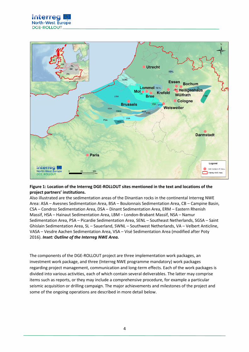
Figure 1: Location of the Interreg DGE-ROLLOUT sites mentioned in the text and locations of the project partners’ institutions. Also illustrated are the sedimentation areas of the Dinantian rocks in the continental Interreg NWE Area: ASA – Avesnes Sedimentation Area, BSA – Boulonnais Sedimentation Area, CB – Campine Basin, CSA – Condroz Sedimentation Area, DSA – Dinant Sedimentation Area, ERM – Eastern Rhenish Massif, HSA – Hainaut Sedimentation Area, LBM – London-Brabant Massif, NSA – Namur Sedimentation Area, PSA – Picardie Sedimentation Area, SENL – Southeast Netherlands, SGSA – Saint Ghislain Sedimentation Area, SL – Sauerland, SWNL – Southwest Netherlands, VA – Velbert Anticline, VASA – Vesdre Aachen Sedimentation Area, VSA – Visé Sedimentation Area (modified after Poty 2016). Inset: Outline of the Interreg NWE Area.
The components of the DGE-ROLLOUT project are three implementation work packages, an
investment work package, and three (Interreg NWE programme mandatory) work packages
regarding project management, communication and long-term effects. Each of the work packages is
divided into various activities, each of which contain several deliverables. The latter may comprise
items such as reports, or they may include a comprehensive procedure, for example a particular
seismic acquisition or drilling campaign. The major achievements and milestones of the project and
some of the ongoing operations are described in more detail below.
5
2. Work Packages: Project Management, Communication and Long Term The activities in the Work Package Project Management (WP M), primarily comprise the organization,
realization and documentation of the two to three day-long partner meetings, which are typically
held three times per year – so far eight partner meetings – and yearly a conference. Due to CoViD-19
all events have been held virtually since April 2020. Additionally, two meetings of the finance officers
took place and several work package related meetings. Further DGE-ROLLOUT participated in the
seminar for approved projects, and the NWE impact meeting 2019.
WP M also includes the risk management and the finance management, as well as the reporting of
the expenses and accomplished deliverables to the Interreg NWE Programme. These tasks are
carried out by the Lead Partner GD NRW supported by the company europiZe UG
(www.europize.eu).
The Work Package Communication (WP C) is organized by the project partner Fh-IEG. Current
activities within the DGE-ROLLOUT project can be found at the project webpage
www.nweurope.eu/DGE-ROLLOUT, and are posted on a regular basis on the project’s Twitter
account @DGE–ROLLOUT as well as on the individual webpages and social media accounts of the
project partners. In addition, several of the project partners present their work at national and
international conferences and workshops, or publish articles in scientific journals.
In addition to the maintenance of the project webpage and Twitter account, WP C assists all project
partners in organizing DGE promotional events. A major activity within WP C was the establishment
of a permanent exhibition in the German Mining Museum (www.bergbaumuseum.de/) which
addresses the transition of energy supply from coal mining to geothermal sources. This exhibition
was launched in September 2019, and will be expanded in the near future to include a “Seismological
Data Center” aimed towards making micro-seismic events visible and transparent for the public.
Work Package Long Term (WP LT) is coordinated by GD NRW, and is intended to document the
outcomes of the DGE-ROLLOUT project for future populations and geothermal investigation. WP LT
incorporates aspects from all work packages and activities addressed in the project. One major
component of this work package is the expansion of the DGE-network within the duration of the
DGE-ROLLOUT project, and it is aimed to uphold regular meetings of this network subsequent to the
project’s runtime. The work package also includes the installation of a transnational guidance office
to guide such meetings. Furthermore, WP LT directs the maintenance of the digitally acquired data
within the project, develops action plans to structure further geothermal exploration and to reduce
the uncertainties of potential geothermal targets in NWE, suggests improvements for the current
framework of legal and economic risk, and provides best practice studies for a flexible use of heat
pumps applied to urban district heating networks for both cascading and thermal storage systems.
6
3. Work Package T1 – Mapping and Networking WP Leader GSB, Estelle Petitclerc
Work package T1 (WP T1) intends to provide a common and harmonized knowledge baseline for the
DGE market development in the project area. This baseline includes the DGE resource potential, the
market/investor correlation and the current legal frameworks. WP T1 also identifies the knowledge
disparities between and within the NWE regions helping to prioritize future DGE exploration
investments.
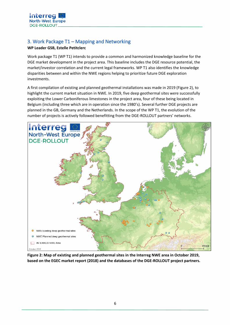
A first compilation of existing and planned geothermal installations was made in 2019 (Figure 2), to
highlight the current market situation in NWE. In 2019, five deep geothermal sites were successfully
exploiting the Lower Carboniferous limestones in the project area, four of these being located in
Belgium (including three which are in operation since the 1980’s). Several further DGE projects are
planned in the GB, Germany and the Netherlands. In the scope of the WP T1, the evolution of the
number of projects is actively followed benefitting from the DGE-ROLLOUT partners’ networks.
Figure 2: Map of existing and planned geothermal sites in the Interreg NWE area in October 2019,
based on the EGEC market report (2018) and the databases of the DGE-ROLLOUT project partners.
7
3.1 Transnational mapping Work Package T1 aims to reveal the subsurface potential of DGE in the Interreg NWE area through
transnational mapping of the Lower Carboniferous (Dinantian) limestone aquifer. A first step in this
was to compile a new stratigraphic chart, and to standardize the definitions of Lower Carboniferous
units to allow for true harmonized transnational mapping.
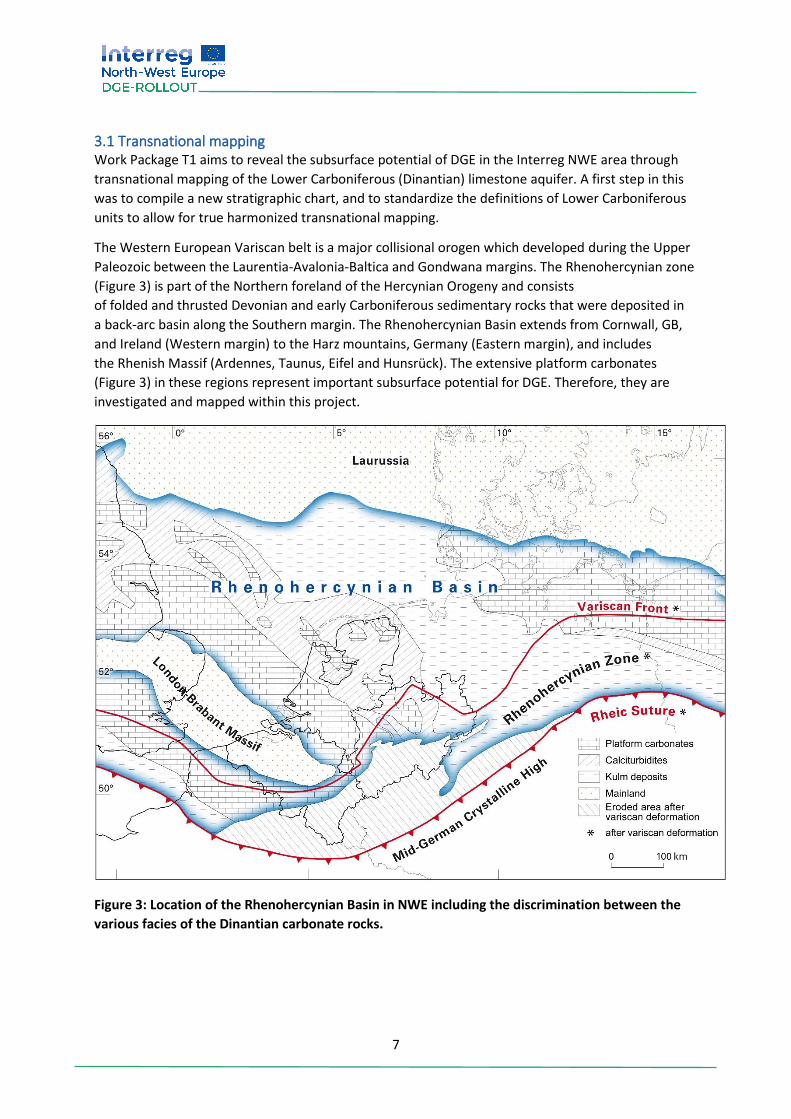
The Western European Variscan belt is a major collisional orogen which developed during the Upper
Paleozoic between the Laurentia-Avalonia-Baltica and Gondwana margins. The Rhenohercynian zone
(Figure 3) is part of the Northern foreland of the Hercynian Orogeny and consists
of folded and thrusted Devonian and early Carboniferous sedimentary rocks that were deposited in
a back-arc basin along the Southern margin. The Rhenohercynian Basin extends from Cornwall, GB,
and Ireland (Western margin) to the Harz mountains, Germany (Eastern margin), and includes
the Rhenish Massif (Ardennes, Taunus, Eifel and Hunsrück). The extensive platform carbonates
(Figure 3) in these regions represent important subsurface potential for DGE. Therefore, they are
investigated and mapped within this project.
Figure 3: Location of the Rhenohercynian Basin in NWE including the discrimination between the
various facies of the Dinantian carbonate rocks.

8
A new stratigraphic chart for the Dinantian in Northern France, Belgium, North Rhine-Westphalia,
and the Netherlands, was developed during the first phase of the DGE-ROLLOUT project. This chart
represents a simplified compilation of the available chronostratigraphic, lithostratigraphic,
biostratigraphic and sequence stratigraphic data of the Dinantian in NWE. There are different
sedimentation areas within this transnational region (Figure 1), which were either separate basins at
the time of deposition or experienced varying degrees of deformation during subsequent tectonism.
The chart includes outcrop information as well as borehole data, which are in some parts the only
source of information about the Dinantian. The last overview of such an extent is from Paproth et al.
(1983). The results from this project are arranged from West to East, following two branches of
outcrops along the London-Brabant Massif (LBM), which meet in the Vesdre-Aachen Sedimentation
Area (VASA). Most of the sedimentation areas comprise abundant carbonate rocks. However, in the
central areas of North Rhine-Westphalia (Velbert Anticline), the Dinantian carbonate facies translate
into the siliciclastic facies of the Kulm Basin (Figure 3). The final version of the harmonized
stratigraphic chart will be provided by DGE-ROLLOUT by the project’s end in October 2022. For
further information on the definitions of the sedimentation areas, please consult the current
literature (e.g., Poty, 2016). The aim of this new stratigraphic overview is to improve the scientific
communication on the different formations of the sedimentation areas and to understand the
transnational spatial relation between them.
A DGE-ROLLOUT borehole database was also set up, which includes 132 boreholes that reach the
Dinantian carbonate horizons. The data include the borehole location, depth at top of the Dinantian
units, thickness of the units, nature of the contact with layers above or below (unconformity or
conformal contact). The lithology served as the basis for the mapping of the geothermal resource.
This database will also allow the evaluation of the uncertainty and the corresponding level of
confidence of the Dinantian top and thickness maps, both which are major deliverables within WP
T1.
These 3D maps of the top and thickness of the Kohlenkalk geothermal reservoir in the area of
interest (Belgium, France, Germany and the Netherlands) are based on existing data, including
reinterpretation of these by various project partners (BRGM, GD NRW, GSB, TNO, TU Da and VITO).
In addition, TU Da carried out an extensive revision of the available geological and geophysical data
to provide a new 3D model of large portions of the Upper Rhine Graben.
A preliminary version of each the harmonized top and thickness map of the Kohlenkalk horizon was
completed in 2020. Major complications which arose during the merging of the individual
contributions of the project partners were inconsistencies near the national borders. These and
other minor issues will be addressed during the remainder of the project. A finalized version of the
transnational harmonized top and thickness map of the Kohlenkalk carbonate horizon is intended for
the end of 2021.
9
3.2 Market evaluation and legal framework In 2021, a market evaluation will assess parameters such as market size and demands, the necessary
up-front investment, and many others, to be correlated with the corresponding investor profiles. The
different NWE investor groups will be mapped. Depending on a particular project location,
economics, risk, policy, as well as different possible investor types will be made available.
Additionally, the heat and power demand in the project partners’ regions will be evaluated, with
focus on areas of economic growth with corresponding increased energy demand. A map will be
created which combines both of these products, with the goal to provide a visual representation of
the socio-economic potential for DGE investors. Previous projects (e.g., Geothermica, ETIP-DG,
GeoHEAT, GeoELEC) surveyed the legal framework in some regions, but this exercise was not
conducted for the entire Interreg NWE project area. An update of the current regulation of each
region was carried out in the DGE-ROLLOUT project in 2020.
Furthermore, legal experts will provide comparative tables of existing DGE regulations, including
definitions of DGE, licensing perimeter, environmental regulations and risk management. This work
will result in the preparation and communication of recommendations to relevant regional and
national policy makers.
3.3 Identification of hot-spot areas A global perspective will be obtained through an online map application merging the three baseline
sources (subsurface resource, market/investors (surface heat demand) and legal framework). This
end-user web application will be useful in identifying regional investment hotspots according to
investor profiles, as well as facilitating a long-term vision for geothermal market development in
NWE for policy makers. This user-friendly tool will be hosted by the European Geographical Data
Infrastructure (EGDI) to ensure long-term sustainability. The results will be communicated to all
potential stakeholders to aid in enlarging the renewable DGE energy market in the high-energy
demanding NWE region. To enable a continuous improvement in usage and knowledge of DGE, a
DGE-network will be established with proposed activities to share experiences and foster
communications in the course of WP LT.
10
4. Work Package T2 – Decision and Exploration Support WP Leader EBN, Timme van Melle
With a financial volume of 9.8 million euro, the Work Package T2 (WP T2) is the most financially
substantial work package within the DGE-ROLLOUT project. Major activities include seismic
campaigns and other types of subsurface data collection in Belgium, France, Germany and the
Netherlands. The overall goal of WP T2 is to fill in the information gaps identified in WP T1, and
utilize that information to better identify and understand geothermal project opportunities.
An important part of WP T2, and the entire DGE-ROLLOUT project, is the transnational seismic
campaign spanning from the east of the Netherlands to the South of Wallonia, South of Belgium.
Three partners share in this effort: GSB for the Walloon region, VITO for the Flanders area, and EBN
for the Dutch portion. These partners work closely together, sharing information, knowledge, best
practices and results. The work is carried out conjointly with other project partners as much possible
with the aim of providing continuous, cross-regional insight into the subsurface and the potential for
geothermal energy.
In the Netherlands the seismic campaign is connected to the national SCAN programme
(scanaardwarmte.nl), which has a similar objective as DGE-ROLLOUT. The SCAN programme makes all
data available to both the project partners and to associated stakeholders within the project. Two
seismic lines are part of the DGE-ROLLOUT project (Figure 4) and will provide better insight into the
targeted Carboniferous limestone layers (Kohlenkalk Group) considered to serve as a hydrothermal
reservoir for energy extraction across the NWE region. These seismic lines are designed to
complement and aid in the overall subsurface regional mapping (WP T1). There has been close
coordination between project partners to ensure the work of WP T2 will result in a seamless
mapping of the subsurface across the different municipalities.
The exploration in Belgium carried out by VITO focuses on the Northwest Limburg area. The
geothermal potential of this area appears promising, however, its seismic coverage is low. A 2D
seismic survey including three lines with a combined length of more than 50 km was completed in fall
2020, along the region of Lommel (VITO 1-3, Figure 4). This data is also connected to the existing
seismic and borehole data further West near Mol. In collaboration with EBN, the VITO survey was
extended into the Netherlands (Noord-Brabant) to connect the Belgian and Dutch seismic data sets.
Processed results of the survey are expected to be available in spring 2021.
Project partner GSB intends to carry out a Walloon 2D seismic survey in 2021 (Figure 4) to determine
the presence of potential Carboniferous geothermal reservoirs below the Midi-Eifelian fault in
Belgium. It is planned to implement vibro-seismic investigations along two profiles with a total length
of 60 km. The main objective of the campaign is to better understand the Walloon subsurface, in
particular the geometry, the main structures and the lithological characteristics from the units of the
relatively unknown Variscan front (parautochthonous Brabant, sheets and upturned massifs from
Haine-Sambre-Meuse, and the Midi-Eifelian fault) to the allochthonous material.
In addition to seismic acquisition, re-processing is also an important aspect of the project. This
includes taking existing field data and using the increased computing capacity available today to get
better results from the computer-based ‘processing’ step. In the North of France, BRGM is carrying
out such reprocessing activities. The results are currently being studied in detail.
11
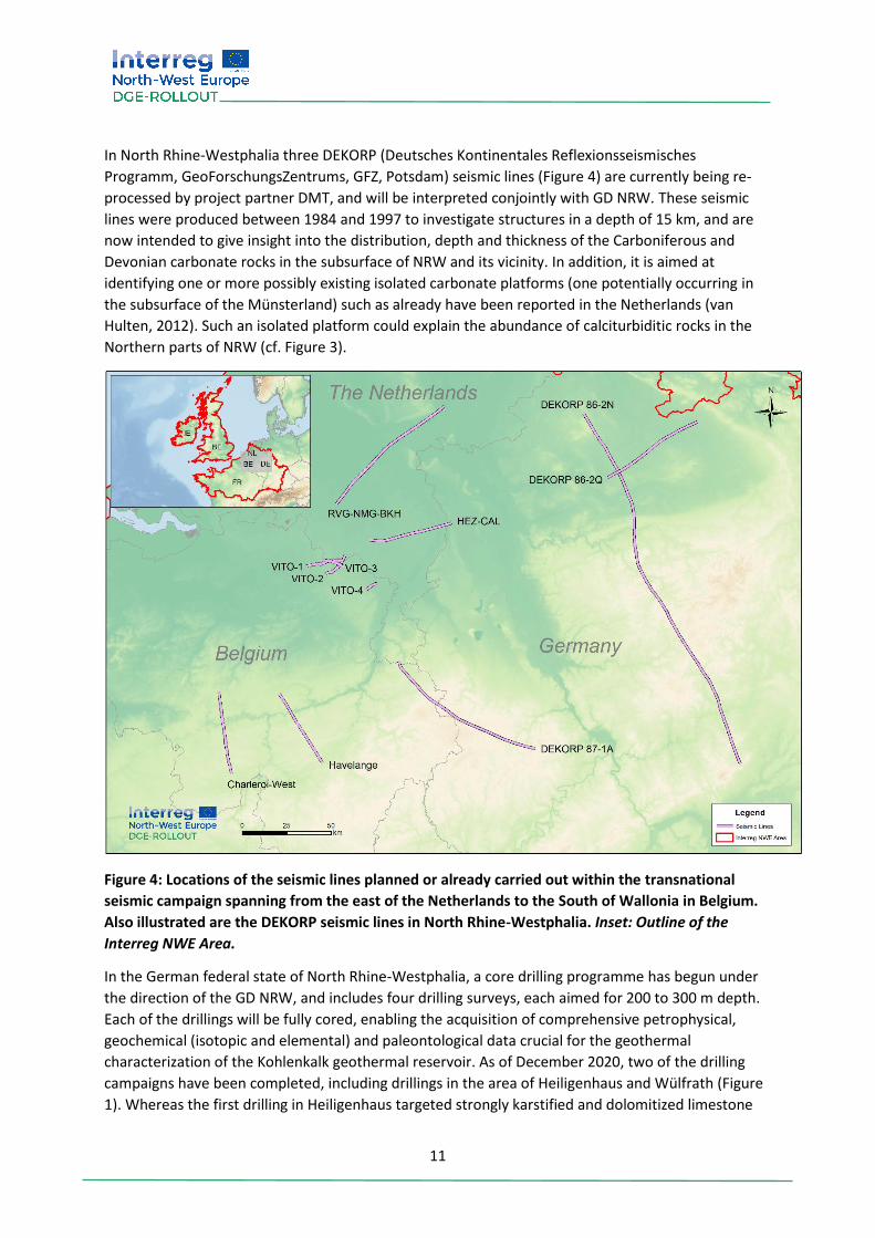
In North Rhine-Westphalia three DEKORP (Deutsches Kontinentales Reflexionsseismisches
Programm, GeoForschungsZentrums, GFZ, Potsdam) seismic lines (Figure 4) are currently being re-
processed by project partner DMT, and will be interpreted conjointly with GD NRW. These seismic
lines were produced between 1984 and 1997 to investigate structures in a depth of 15 km, and are
now intended to give insight into the distribution, depth and thickness of the Carboniferous and
Devonian carbonate rocks in the subsurface of NRW and its vicinity. In addition, it is aimed at
identifying one or more possibly existing isolated carbonate platforms (one potentially occurring in
the subsurface of the Münsterland) such as already have been reported in the Netherlands (van
Hulten, 2012). Such an isolated platform could explain the abundance of calciturbiditic rocks in the
Northern parts of NRW (cf. Figure 3).
Figure 4: Locations of the seismic lines planned or already carried out within the transnational
seismic campaign spanning from the east of the Netherlands to the South of Wallonia in Belgium.
Also illustrated are the DEKORP seismic lines in North Rhine-Westphalia. Inset: Outline of the
Interreg NWE Area.
In the German federal state of North Rhine-Westphalia, a core drilling programme has begun under
the direction of the GD NRW, and includes four drilling surveys, each aimed for 200 to 300 m depth.
Each of the drillings will be fully cored, enabling the acquisition of comprehensive petrophysical,
geochemical (isotopic and elemental) and paleontological data crucial for the geothermal
characterization of the Kohlenkalk geothermal reservoir. As of December 2020, two of the drilling
campaigns have been completed, including drillings in the area of Heiligenhaus and Wülfrath (Figure
1). Whereas the first drilling in Heiligenhaus targeted strongly karstified and dolomitized limestone
12
samples of the reef facies of the Kohlenkalk Group, the subsequent drilling in Wülfrath targeted the
turbiditic facies which during deposition encircled the reef (Figure 3).
In addition to geophysical studies of the borehole (spectral gamma ray, gamma ray, salinity,
temperature, magnetic susceptibility, and others) and thermal conductivity measurements of the
Heiligenhaus core, analyses include carbon and oxygen isotope (δ13C and δ18O) analyses, fluid
inclusion thermometry, as well as porosity and permeability measurements. The latter
methodologies are conducted in cooperation with associated project partner Ruhr-University
Bochum (RUB) and project partner TU Da. The lithologic and stratigraphic recording of the Wülfrath
core was also recently completed. Chronological classification via conodont biostratigraphy of the
Wülfrath core is planned for early 2021 in collaboration with the University of Cologne.
Other activities included in WP T2 are directed towards technical and economic modelling, and the
collection and dissemination of information. Amongst others, DMT has presented advancements of
their software HEATFLOW-3D to better theorize thermo-hydraulic processes within the context of
geothermal heat and storage systems, for example in abandoned mines. Additionally, GSB is working
on a techno-economic model that allows the assessment of a number of policy instruments in order
to stimulate new geothermal energy projects. This model currently considers case studies. TNO will
use the outcome of WP T1 and WP T2 for an update of the ThermoGis application
(https://www.thermogis.nl/en), which provides insight in geothermal potential for specific locations
in the region.
13
5. Work Package T3 – Testing for production optimization WP Leader VITO, Matsen Broothaers
The work package on production optimization (WP T3) combines contributions from several partners,
and primarily involves the execution of deep geothermal energy. The objective of WP T3 is to
increase the efficiency of geothermal systems and to create additional CO2 reduction through the
implementation of improved production techniques stemming from a better understanding of
reservoir behaviour, energy cascading/use and thermal energy storage.
5.1 Experience from the Balmatt geothermal site The first facet of WP T3 concerns production technology and mainly revolves around VITO’s
geothermal power plant on the Balmatt site in Mol (https://vito.be/en/deep-geothermal/balmatt-
energy-plant). Development of the geothermal plant began prior to 2010 with feasibility studies and
seismic exploration, which led to the drilling of three wells on site (Bos and Laenen, 2017; Broothaers
et al., 2019). All wells targeted the Lower Carboniferous limestone sequence (Kohlenkalk Group) at a
depth greater than 3,000 m. The third well continued into the underlying Devonian sandstone
(Condroz Sandstone).
After completing the surface installations and connecting the plant to the existing heating network,
the start-up phase initiated in November 2018 and continued until June 2019. During that time,
fourteen periods (covering between 0.5 and 240 operational hours) of test operation were carried
out, comprising injection in the well Mol-GT-02 and production from Mol-GT-01. A total of 50,000 m³
of geothermal brine was produced, with a corresponding 3,200 MWh of extracted heat. The energy
was either used for heating or for the production of power by means of an organic rankine cycle.
Fluids from deep geothermal reservoirs may pose challenges related to their composition (such as
the presence of gas), the occurrence of naturally occurring radioactive material, corrosion and
scaling. These challenges were identified during the test periods in Mol. The brine at the Balmatt site
had a gas content of 2.5 Nm³/m³, mainly CO2. Due its nature, separation of the gas from the fluid
would impact the chemical composition of the brine and on the potential of scaling. Therefore, it was
decided to keep the system pressure above the bubble point. Nevertheless, it became clear during
testing that free gases were present in the surface installations. Preventing gas release requires an
increase in system pressure, but in order to achieve this some components of the power plant
apparatus needed adaptation as they were not designed for elevated pressure (up to 55 bar). Since
free gas was not only detected in the piping but also in the top of the injection well, a tubing was
installed to help preventing turbulent flow in the crossing between the surface installations and the
casing.
Corrosion and scaling were two other issues carefully analyzed during the start-up phase. The proper
functioning of the corrosion inhibitor was evaluated during corrosion inspections. Measurements
from milllipore filtration indicated the presence of suspended solids in the brine. The proper
functioning of the scaling inhibitor was evaluated through the amount and type of material in the
filter elements, which were analyzed by X-ray diffraction, X-ray fluorescence, and total
organic/inorganic carbon analyses, as well as by rock-eval pyrolysis. The main precipitate in the filter
elements was Galena (PbS). Based on these observations the mesh of the filter elements and the
inhibitors were adapted with the goal of avoiding Galena formation.
14
Another key challenge for geothermal operations is the occurrence of seismicity. To better document
and understand this seismicity, a seismic monitoring network was installed in 2016 which includes a
traffic light system. The strongest seismic event detected during the start-up phase (ML 2.2) was
recorded in June 2019, following the longest test period. Subsequent analysis of the data from the
seismic monitoring network was performed to better understanding the seismological behaviour of
the subsurface in Mol (not part of the DGE-ROLLOUT Project). This led to an extension of the existing
seismometer network. Once operations begin again, the efficiency of the changes in the surface
installations will comprehensively be evaluated.
5.2 Heat demand management and thermal energy storage The success of a geothermal site is not only determined by subsurface (reservoir) characteristics and
the surface installations used to address the challenges posed by geothermal brine. The heat or
power a system produces is naturally determined by the surface heat demand. To make efficient use
of the heat produced from a geothermal doublet, it is essential to understand the heat demand
which is required in its vicinity, how it fluctuates on a daily or seasonal basis, and how it can be
coupled to the system network. These topics are analyzed by VITO and Fh-IEG for both the Balmatt
and TRUDI sites in Mol and Bochum, respectively. VITO identified potential heat consumers and is
collecting relevant heat data. Moreover, innovative heat demand management will impact the
energy efficiency of the plant. Cascading strategies will be evaluated, taking into account the
utilization of the source, internal energy consumption of the geothermal plant, and energy loss. This
is because cascading can result in significantly lower injection temperature and hence provide a
better utilization of the geothermal source. Based on input of heat demand on a monthly and hourly
basis, and considering the ambient temperature and techno-economic parameters, the potential for
heat demand management is calculated (e.g., peak shaving).
Cascading is not the only option to improve the system efficiency. Heat storage can also provide a
significant contribution. TU Da is studying the use of borehole thermal energy storage (BTES) systems
at medium depth and their role in district heating networks. Thermal energy storage allows
optimization of heat delivery from a geothermal source toward a district heating grid by removing
imbalances between heat demand and supply. These theoretical studies are accompanied by the
construction of a pilot BTES to 750 m depth to improve predictability of BTES system performance.
An initial step is the generation of a 3D model of the fractured and faulted crystalline rocks by
analogue studies. The model will be validated by geophysical measurements collected during the
construction and operation of the pilot BTES system. The validated benchmark model can serve as a
basis for a detailed 3D finite elements method model of BTES. Using co-simulation, the BTES model
will be coupled to a model of the district heating system at TU Da to evaluate the integration of an
upscaled medium-deep BTES. Furthermore, the benchmark model can be used to calibrate and
validate simplified BTES models for fast system simulations (Formhals et al., 2020).
5.3 Integration of geothermal energy into the Weisweiler lignite-fired power plant Karstified and dolomitized limestones of the Kohlenkalk Group (Lower Carboniferous) and the
Massenkalk Facies (Upper Devonian) are targeted for the extraction of hydrothermal energy at the
Weisweiler Power Plant (cf. Figure 1). The aim is to integrate the DGE into the existing district heating
network fed by the lignite-fired power plant Weisweiler (RWE) following the forthcoming fossil fuel
phase-out.
15
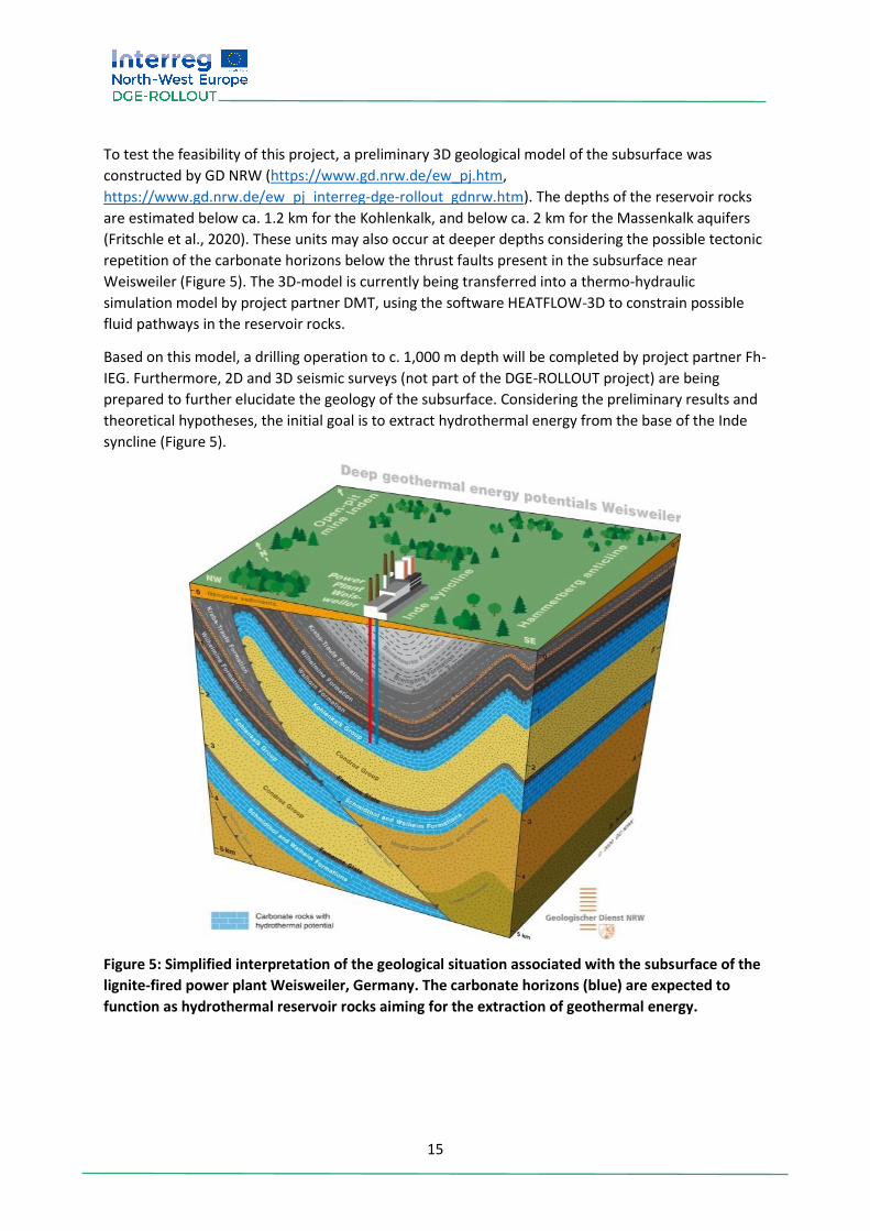
To test the feasibility of this project, a preliminary 3D geological model of the subsurface was
constructed by GD NRW (https://www.gd.nrw.de/ew_pj.htm,
https://www.gd.nrw.de/ew_pj_interreg-dge-rollout_gdnrw.htm). The depths of the reservoir rocks
are estimated below ca. 1.2 km for the Kohlenkalk, and below ca. 2 km for the Massenkalk aquifers
(Fritschle et al., 2020). These units may also occur at deeper depths considering the possible tectonic
repetition of the carbonate horizons below the thrust faults present in the subsurface near
Weisweiler (Figure 5). The 3D-model is currently being transferred into a thermo-hydraulic
simulation model by project partner DMT, using the software HEATFLOW-3D to constrain possible
fluid pathways in the reservoir rocks.
Based on this model, a drilling operation to c. 1,000 m depth will be completed by project partner Fh-
IEG. Furthermore, 2D and 3D seismic surveys (not part of the DGE-ROLLOUT project) are being
prepared to further elucidate the geology of the subsurface. Considering the preliminary results and
theoretical hypotheses, the initial goal is to extract hydrothermal energy from the base of the Inde
syncline (Figure 5).
Figure 5: Simplified interpretation of the geological situation associated with the subsurface of the
lignite-fired power plant Weisweiler, Germany. The carbonate horizons (blue) are expected to
function as hydrothermal reservoir rocks aiming for the extraction of geothermal energy.
16
5.4 Further activities within WP T3 A flexible integration of geothermal plants with district heating is essential for a large-scale roll-out of
DGE. The efficiency of the tested techniques will be evaluated in three case studies involving the
Weisweiler district heating grid and the heating networks at the potential geothermal sites in
Lommel and Bree (cf. Figure 1). The final work in WP T3 considers the implementation of knowledge
gained from previous studies and production for these three sites. The first phase of this work
includes analyzing the geothermal potential of the subsurface (partly based on data acquired in WP
T2). Options for energy cascading are evaluated, while considering both the estimated production
temperature and local heat demand. The potential for energy cascading and heat storage combined
with local heat demand are used to produce a conceptual design of a geothermal district heating
grid, which provides input parameters for the evaluation of techno-economic feasibility.
17
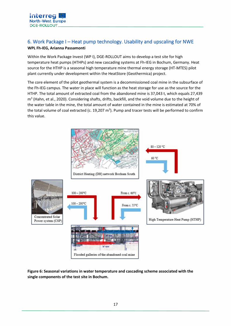
6. Work Package I – Heat pump technology. Usability and upscaling for NWE WPL Fh-IEG, Arianna Passamonti
Within the Work Package Invest (WP I), DGE-ROLLOUT aims to develop a test site for high
temperature heat pumps (HTHPs) and new cascading systems at Fh-IEG in Bochum, Germany. Heat
source for the HTHP is a seasonal high temperature mine thermal energy storage (HT-MTES) pilot
plant currently under development within the HeatStore (Geothermica) project.
The core element of the pilot geothermal system is a decommissioned coal mine in the subsurface of
the Fh-IEG campus. The water in place will function as the heat storage for use as the source for the
HTHP. The total amount of extracted coal from the abandoned mine is 37,043 t, which equals 27,439
m3 (Hahn, et al., 2020). Considering shafts, drifts, backfill, and the void volume due to the height of
the water table in the mine, the total amount of water contained in the mine is estimated at 70% of
the total volume of coal extracted (c. 19,207 m3). Pump and tracer tests will be performed to confirm
this value.
Figure 6: Seasonal variations in water temperature and cascading scheme associated with the
single components of the test site in Bochum.
18
Using a finite element numerical simulation and a 3D representation of the site, the best drilling
spots for injection, production and monitory wells were determined in collaboration with delta h
Ingenieurgesellschaft mbH (König, et al., 2018). The three wells penetrating the mine were drilled in
2020 by Fh-IEG.
The district heating (DH) network of Southern Bochum, which will be fed by the geothermal system,
has a total capacity of 115 MW. The supply temperature needed for the DH network varies from 80
to 120°C considering daily changes, with an expected return temperature of 60°C. Seasonal
temperature variations of the system and the associated cascading scheme is shown in Figure 6.
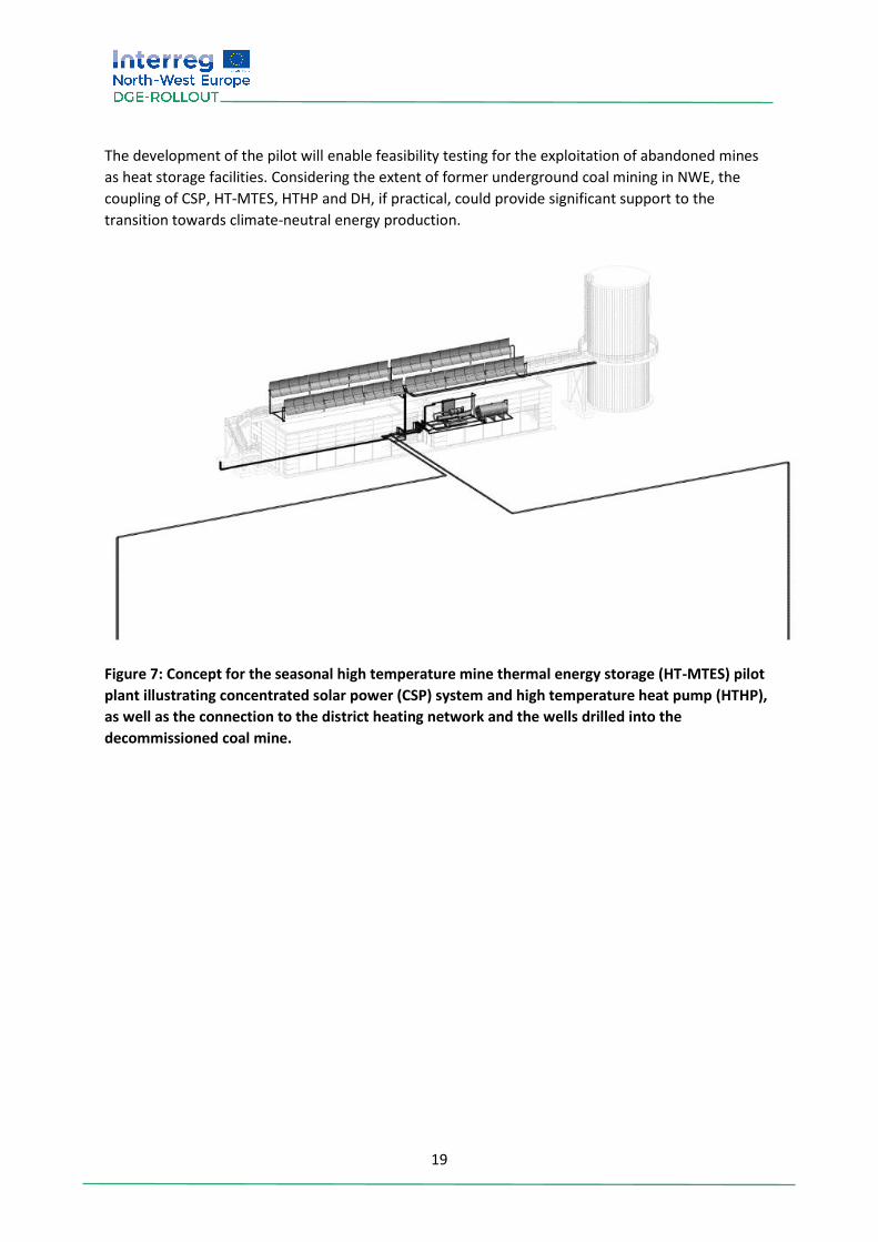
6.1. Concept of the seasonal high temperature mine thermal energy storage (HT-MTES) pilot plant The small flooded colliery used as the heat storage is located at 75 m below ground level (b.g.l.),
inclosing a water table at 23 m b.g.l.. The temperature of the water in the beginning of heating
period is expected to be c. 60°C and if unheated, would decrease to 12°C by the end of the season
following its exploitation by the HTHP. However, to support the HTHP and raise the efficiency of the
geothermal system, heating the water contained in the mine using 12 parabolic trough solar
collectors on two rows is being considered. This concentrated solar power (CSP) system is expected
to produce water at a temperature between 100 and 200°C (depending on the control system
strategy and the solar irradiation), which equals a total of 60 kW peak heat capacity, with a possibility
of extension in the future. The concept for the seasonal HT-MTES pilot plant coupled with HTHP is
shown in Figure 7.
6.2. Requirements for the high temperature heat pump system A heating of the entire water volume in the mine to a temperature of 60°C would theoretically
produce 500 kW of power. Heat pump models with a high level of power modulation are preferred to
optimal use of the source.
The requirements expected from the heat pump are challenging, and include high modulation of
powers, seasonal temperature variations of the source, daily temperature variations of the sink and
the heat pump supply temperature of 120°C. District heating grids with elevated supply
temperatures (e.g., 120°C) are not normally fed by heat pumps, but serve supply temperatures up to
90°C. Based on current knowledge, supply temperatures between 100 and 140°C is at prototype
status and applied for industrial purposes.
Further considerations should also be made for the HTHP refrigerants, which should preferably have
a high critical temperature, low critical pressure, ozone depletion potential of 0, low global warming
potential and short atmospheric lifetime. The refrigerants should also be non-toxic, non-combustible,
allow high performance coefficients as well as specific performance requirements.
6.3. Major results, conclusion and outlook of WP Invest Three wells drilled into the HT-MTES within the scope of the HeatStore (Geothermica) project will
also be utilized within DGE-ROLLOUT. Despite problematic boundary conditions for the functionality
of the HT-MTES pilot plant, possible suppliers for HTHPs were identified.
Next steps include pump and tracer tests to determine the storage capacity inside the mine. The
detailed development of the hydraulic system to connect various components in the cascading
scheme is also in progress.
19
The development of the pilot will enable feasibility testing for the exploitation of abandoned mines
as heat storage facilities. Considering the extent of former underground coal mining in NWE, the
coupling of CSP, HT-MTES, HTHP and DH, if practical, could provide significant support to the
transition towards climate-neutral energy production.
Figure 7: Concept for the seasonal high temperature mine thermal energy storage (HT-MTES) pilot
plant illustrating concentrated solar power (CSP) system and high temperature heat pump (HTHP),
as well as the connection to the district heating network and the wells drilled into the
decommissioned coal mine.
20
7. Conclusions and Outlook By now, half of the DGE-ROLLOUT project’s runtime has passed. The work achieved thus far is well in
line with the objectives and results laid out in the original application form. An appraisal meeting was
held in September 2020 with the Interreg Project Officer and German Contact Point attending, who
confirmed that the project is on track. Additionally, the Interreg officials were pleased with the
partnership dynamics and working relationships amongst the project partners.
Although the project has experienced some delays in spending and implementation, mainly in regard
to a delayed project start due to staff employment, as well as the CoViD-19 pandemic, there have
been a number of valuable outcomes and achievements which often arose from regional and
transnational collaboration. Most importantly these include: the preliminary transnational depth and
thickness maps of the Kohlenkalk aquifer in NWE, the harmonized transnational stratigraphic chart,
and the initial results from the drilling of cores in NRW with corresponding petrophysical and
geochemical analyses, as well as lithostratigraphic descriptions.
In addition, DGE-ROLLOUT organized several national and transnational workshops and seminars,
which received significant public attention and positive response. One of these, the virtual
conference “Deep Geothermal - Technical Challenges, Uncertainties & Risks", which was held in
autumn 2020, reached over 130 participants from 15 countries. Similarly, the permanent exhibition
in the German Mining Museum on the transition from coal mining to geothermal resources has been
well received and has very beneficial feedback. We look forward to its further development and
expansion.
The promotion of DGE, which has been one of the major aims of the project from its beginning on, is
also well on track. This becomes obvious especially when considering the incorporation of the DGE-
ROLLOUT project as a “lighthouse project” in the Energieforschungsbericht 2020 (report on energy
research) published by the German federal state of North Rhine-Westphalia
(https://www.energieforschung.nrw/energieforschungsbericht/2020/energiesystem-der-
zukunft#leuchtturmprojekteenergiesystem,
https://broschuerenservice.land.nrw/files/8/e/8e906ef6fcb02d37162348c2182c730f.pdf).
The work intended for 2021 and 2022 will be crucial for the further success of the project. During
that time, most of the planned seismic campaigns will be undertaken, the heat pump will be
purchased, and the deep drilling in Weisweiler, Germany, will be implemented. Moreover, the first
results of the project will be submitted to scientific journals, including a special issue of the Zeitschrift
der Deutschen Gesellschaft für Geowissenschaften – Journal of Applied and Regional Geology
(ZDGG), which will include over ten publications mostly from work carried out within the DGE-
ROLLOUT project. Reports compiled in 2020 on the legal framework as well as on the financial risk
management of DGE projects, will also be supplemented with reports on recommendations for
improvements of these fundamental topics.
Overall, the DGE-ROLLOUT partnership is very much looking forward to the second phase of the
project, particularly to expected short term results. The partnership is also very eager to holding in-
person meetings again, as they are essential part for transnational collaboration within the DGE-
ROLLOUT project, which has become even more obvious throughout the current pandemic situation.