Microsoft Word - 11_1010_GeoSl_BA_NMFS.docx Web viewAECOMWest False River Salinity Barrier...
55
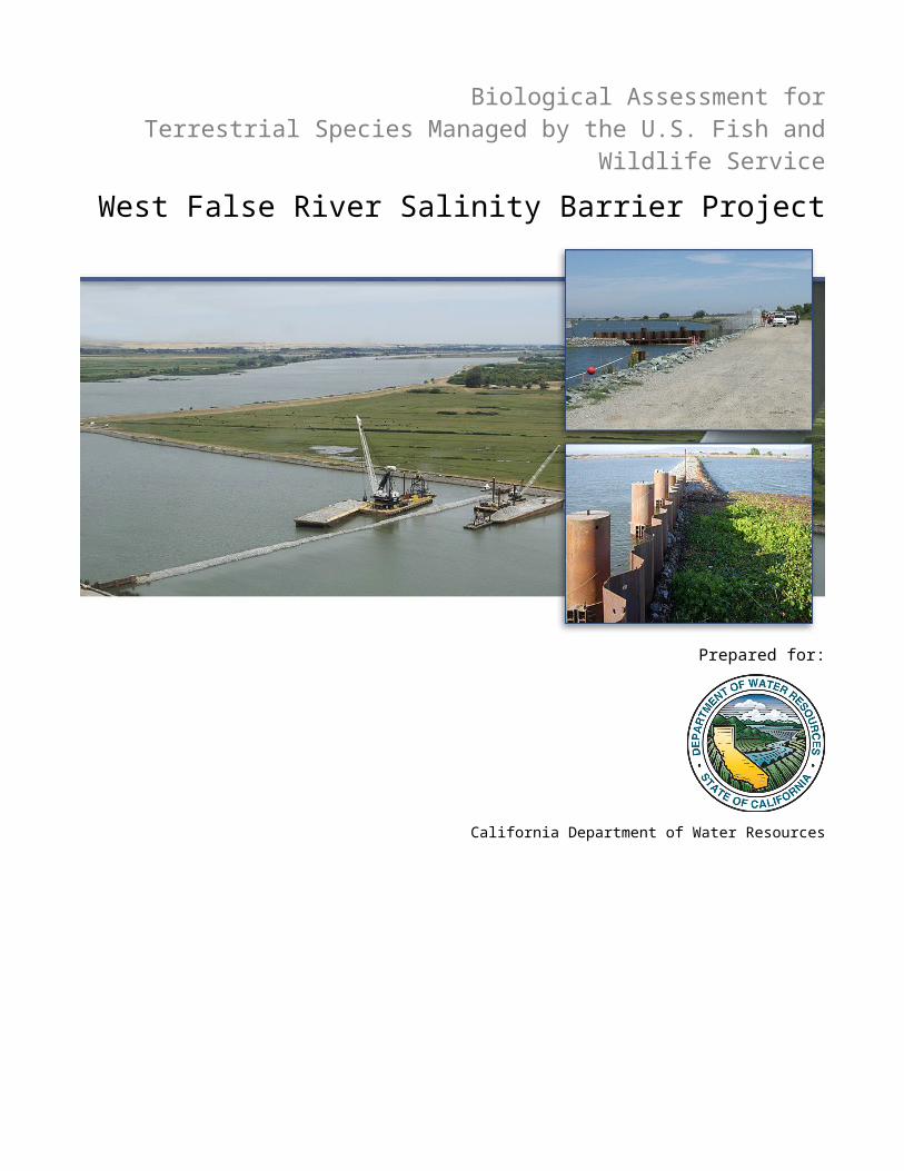
Biological Assessment for Terrestrial Species Managed by the U.S. Fish and Wildlife Service West False River Salinity Barrier Project Prepared for: California Department of Water Resources
Transcript of Microsoft Word - 11_1010_GeoSl_BA_NMFS.docx Web viewAECOMWest False River Salinity Barrier...
Biological Assessment forTerrestrial Species Managed by the U.S. Fish and Wildlife Service
West False River Salinity Barrier Project
Prepared for:
California Department of Water Resources
September 2015

Biological Assessment forTerrestrial Species Managed by the U.S. Fish and Wildlife Service
West False River Salinity Barrier Project
Prepared for:
California Department of Water Resources 1416 9th Street
Sacramento, CA 94236-001
Contact:Jacob McQuirk916/653-9883
Prepared by:AECOM
2020 L Street, Suite 400Sacramento, CA 95811
Contact:Cindy Davis
Project Manager916/414-5800
6031756209.22.15 September 2015

TABLE OF CONTENTS1 INTRODUCTION..............................................................................................................................................1
2 CONSULTATION HISTORY.............................................................................................................................1
3 PURPOSE AND SCOPE OF THIS BIOLOGICAL ASSESSMENT.........................................................................2
4 PROJECT DESCRIPTION................................................................................................................................34.1 Project Location................................................................................................................................34.2 Barrier Installation and Operation....................................................................................................34.3 Barrier Removal................................................................................................................................8
5 CONSERVATION MEASURES.........................................................................................................................9
6 ACTION AREA..............................................................................................................................................15
7 LIFE HISTORY.............................................................................................................................................16
8 ENVIRONMENTAL BASELINE......................................................................................................................168.1 Status of the Species in the Action Area.........................................................................................168.2 Factors Affecting the Species and Habitat in the Action Area.......................................................17
9 EFFECTS ASSESSMENT................................................................................................................................18
10 CUMULATIVE EFFECTS...............................................................................................................................19
11 CONCLUSION...............................................................................................................................................20
12 REFERENCES................................................................................................................................................20
Appendices
Appendix A USFWS Species ListAppendix B Photographs of the Action Area
West False River Salinity Barrier Project AECOMDepartment of Water Resources i Biological Assessment

FiguresFigure 1. Location of the Proposed Barrier 4Figure 2. Aerial View of the Project Site 5Figure 3. Photographs of the Project Site 6Figure 4. Stockpile Location 10
Tables
Table 1 Construction Equipment Anticipated to be Used for Barrier Installation 7Table 2 Construction Equipment Anticipated to be Used for Barrier Removal 9
AECOM West False River Salinity Barrier ProjectBiological Assessment ii Department of Water Resources
ACRONYMS AND ABBREVIATIONSBasin Plan Water Quality Control PlanBOs Biological OpinionsCalOES Governor’s Office of Emergency ServicesCDFW California Department of Fish and WildlifeCESA California Endangered Species ActCNDDB California Natural Diversity DatabaseCVP Central Valley ProjectDelta Sacramento-San Joaquin River DeltaDWR Department of Water ResourcesEDB emergency drought barrierESA Endangered Species ActHAZMAT hazardous materialsHMMP Hazardous Materials Management ProgramITP Incidental Take PermitLMA Local Maintaining AgencyNMFS National Marine Fisheries ServiceReclamation Bureau of ReclamationSEL sound exposure levelSWP State Water ProjectSWRCB State Water Resources Control BoardUSACE U.S. Army Corps of EngineersUSFWS U.S. Fish and Wildlife ServiceWFRSB West False River Salinity Barrier
West False River Salinity Barrier Project AECOMDepartment of Water Resources iii Biological Assessment

This page intentionally left blank.
AECOM West False River Salinity Barrier ProjectBiological Assessment iv Department of Water Resources
1 INTRODUCTION
Faced with potentially insufficient water supplies to repel salinity in the Sacramento-San Joaquin River Delta (Delta), the California Department of Water Resources (DWR) installed the Emergency Drought Barrier (EDB) across West False River in May-July 2015. Installation of the EDB was authorized under Executive Order B-29-15 (April 1, 2015 Directive to Streamline Government Response) and environmental authorizations from the U.S. Army Corps of Engineers (USACE) (SPK-2014-00187), State Water Resources Control Board (SWRCB) (Clean Water Act Section 401 Water Quality Certification), and California Department of Fish and Wildlife (CDFW) (2081-2014-026-03 and 1600-2014-0111-R3). Per the USACE Clean Water Act 404 emergency authorization, the EDB was removed entirely in fall 2015.
The proposed West False River Salinity Barrier Project (WFRSB or Project) seeks to protect the quality of water for users that rely on Delta water. Keeping saltwater out of the central Delta is a priority, as a large portion of the state’s freshwater supplies travels through this part of the Delta. As shown with the EDB, a salinity barrier helps prevent saltwater contamination of water supplies used by people who live in the Delta and in Contra Costa, Alameda, and Santa Clara counties, as well as the 25 million people who rely on the Delta-based federal and state water projects for at least some of their supplies.
The WFRSB consists of the following items:
► installing embankment rock (i.e., temporary salinity barrier) and abutments (king piles, sheet piles, and whalers) beginning April 1, 2016; and
► removing the embankment rock and abutments by November 15, 2016.
The WFRSB would only be constructed if DWR determines that a drought has reduced water storage in the State Water Project (SWP) to critical levels, such that projected Delta outflow could not control increased salinity in the Delta, thereby worsening water quality and threatening the drinking and irrigation water supply. Operation of the salinity barrier as part of overall Central Valley Project (CVP) and SWP operations would occur through existing rules and regulations under relevant federal and state regulatory agencies.
2 CONSULTATION HISTORY
Consultation with the U.S. Fish and Wildlife Service (USFWS) and other regulatory agencies on potential installation of one or more barriers began when DWR hosted a coordination meeting on March 5, 2014. Representatives from the USFWS, National Marine Fisheries Service (NMFS), Bureau of Reclamation, USACE, SWRCB, and the AECOM-led consulting team attended this meeting. Subsequently, coordination meetings and calls attended by DWR, the AECOM-led consulting team, and agency representatives were conducted periodically as the proposal for implementing a barrier project developed.
Five biological assessments were submitted to USACE and USFWS between March 2014 and April 2015, addressing several proposals to implement a project that varied in the number and location of proposed barriers and the implementation period and frequency. Eventually, a letter dated April 20, 2015 was submitted to USACE requesting Emergency Procedures be used to secure permits for the EDB project in order to begin in-water
West False River Salinity Barrier Project AECOMDepartment of Water Resources 1 Biological Assessment

installation activities by May 7, 2015. A biological assessment, dated April 28, 2015, was prepared to evaluate the emergency action, and USACE provided the biological assessment to USFWS and requested emergency consultation with USFWS under Section 7 of the ESA (50 CFR 402.05). An additional biological assessment, dated July 10, 2015, was prepared to describe barrier installation activities that were completed in May and July 2015 under the emergency action and anticipated barrier removal methods. The document also presented results of biological field surveys and monitoring conducted before and during barrier installation and evaluated effects on terrestrial species managed by USFWS that occurred during the emergency installation and could occur during barrier operation and removal.
DWR’s proposal to implement a future barrier project has been discussed at several points during the ongoing agency consultation. This biological assessment has been prepared to address the proposed WFRSB.
3 PURPOSE AND SCOPE OF THIS BIOLOGICAL ASSESSMENT
This biological assessment is intended to satisfy the Section 7 consultation requirements of the federal Endangered Species Act (ESA) for terrestrial species managed by the USFWS. Section 7 consultation is required because the USACE is anticipated to authorize fill of waters of the United States via a Clean Water Act Section 404 Individual Permit for the proposed action.
Appendix A includes the USFWS Species List that was generated for Section 7 consultation on the EDB project. This list covers the Jersey Island U.S. Geologic Survey quadrangle, in which the proposed action would be conducted, as well as the surrounding eight quadrangles (Antioch North, Antioch South, Birds Landing, Bouldin Island, Brentwood, Isleton, Rio Vista, and Woodward Island). This biological assessment describes effects potentially resulting from implementation of the proposed action on giant garter snake (Thamnophis gigas). Delta smelt (Hypomesus transpacificus) is separately addressed in a biological assessment prepared for aquatic species.
Many additional species included on the USFWS list generated for the nine quadrangles were evaluated for their potential to occur in the vicinity of the project site and potentially be affected by the proposed action. The following terrestrial species were eliminated from consideration in this biological assessment because the project site is outside of the current range of the species or field observations concluded there is no suitable habitat for the species on, or adjacent to, the project site:
► Lange's metalmark butterfly (Apodemia mormo langei)► Conservancy fairy shrimp (Branchinecta conservatio)► Longhorn fairy shrimp (Branchinecta longiantenna)► Vernal pool fairy shrimp (Branchinecta lynchi) ► Delta green ground beetle (Elaphrus viridis)► Valley elderberry longhorn beetle (Desmocerus californicus dimorphus)► San Bruno elfin butterfly (Incisalia mossii bayensis)► Vernal pool tadpole shrimp (Lepidurus packardi) ► California tiger salamander, central population (Ambystoma californiense) ► California red‐legged frog (Rana draytonii)► Alameda whipsnake (Masticophis lateralis euryxanthus)► California clapper rail (Rallus longirostris obsoletus)
AECOM West False River Salinity Barrier ProjectBiological Assessment 2 Department of Water Resources

► California least tern (Sterna antillarum browni)► Salt marsh harvest mouse (Reithrodontomys raviventris)► San Joaquin kit fox (Vulpes macrotis mutica)► Large-flowered fiddleneck (Amsinckia grandiflora)► Soft bird's-beak (Cordylanthus mollis ssp. mollis)► Contra Costa wallflower (Erysimum capitatum ssp. angustatum)► Contra Costa goldfields (Lasthenia conjugens)► Colusa grass (Neostapfia colusana)► Antioch Dunes evening-primrose (Oenothera deltoides ssp. howellii)► Keck's checker-mallow (Sidalcea keckii)
4 PROJECT DESCRIPTION
4.1 PROJECT LOCATION
DWR would install the WFRSB near, but not identical to, the EDB footprint (Figure 1 and Figure 2). The project site is located on West False River approximately 0.4 mile east of its confluence with the San Joaquin River, between Jersey and Bradford islands in Contra Costa County, and is approximately 4.8 miles northeast of Oakley. The banks of the project site are existing rock-lined levees. The project site would be approximately 4.44 acres, including 2.49 acres of aquatic fill and 1.95 acres on the levee and landside berm for staging. Photographs of the project site during and after installation of the EDB are provided in Figure 3.
4.2 BARRIER INSTALLATION AND OPERATION
4.2.1 DESIGN
The WFRSB would consist of the following structures:
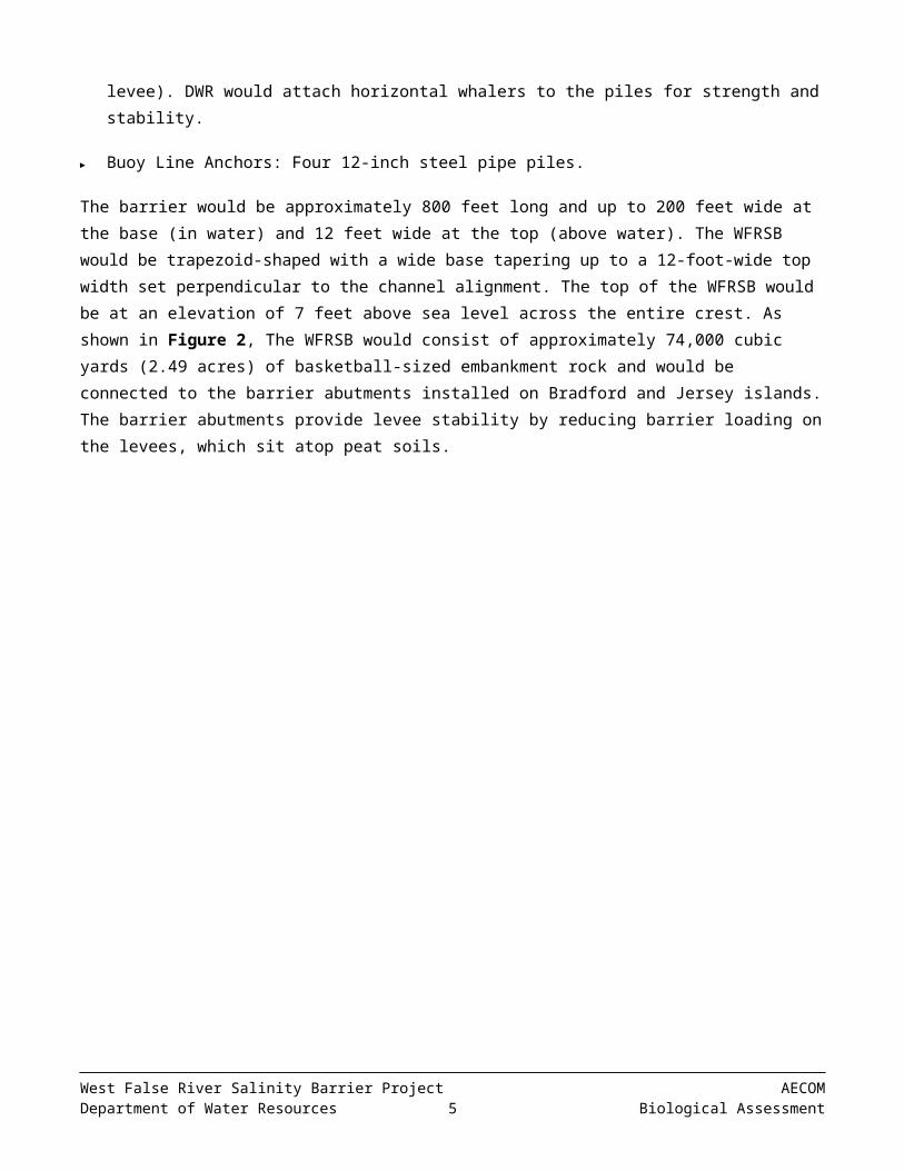
► Barrier Abutments: Eight (or four pairs) 36-inch-diameter king piles extending out from each levee into the West False River channel for a total length of approximately 75 feet.
► Seventy (or 35 pairs) sheet piles totaling approximately 160 wall feet (including approximately 5 feet on either side that would be in the levee). DWR would attach horizontal whalers to the piles for strength and stability.
► Buoy Line Anchors: Four 12-inch steel pipe piles.
The barrier would be approximately 800 feet long and up to 200 feet wide at the base (in water) and 12 feet wide at the top (above water). The WFRSB would be trapezoid-shaped with a wide base tapering up to a 12-foot-wide top width set perpendicular to the channel alignment. The top of the WFRSB would be at an elevation of 7 feet above sea level across the entire crest. As shown in Figure 2, The WFRSB would consist of approximately 74,000 cubic yards (2.49 acres) of basketball-sized embankment rock and would be connected to the barrier abutments installed on Bradford and Jersey islands. The barrier abutments provide levee stability by reducing barrier loading on the levees, which sit atop peat soils.
West False River Salinity Barrier Project AECOMDepartment of Water Resources 3 Biological Assessment
Source: DWR 2015, AECOM 2015
Figure 1. Location of the Proposed Barrier
AECOM West False River Salinity Barrier ProjectBiological Assessment 4 Department of Water Resources

Source: DWR 2015, AECOM 2015
Figure 2. Aerial View of the Project Site
West False River Salinity Barrier Project AECOMDepartment of Water Resources 5 Biological Assessment

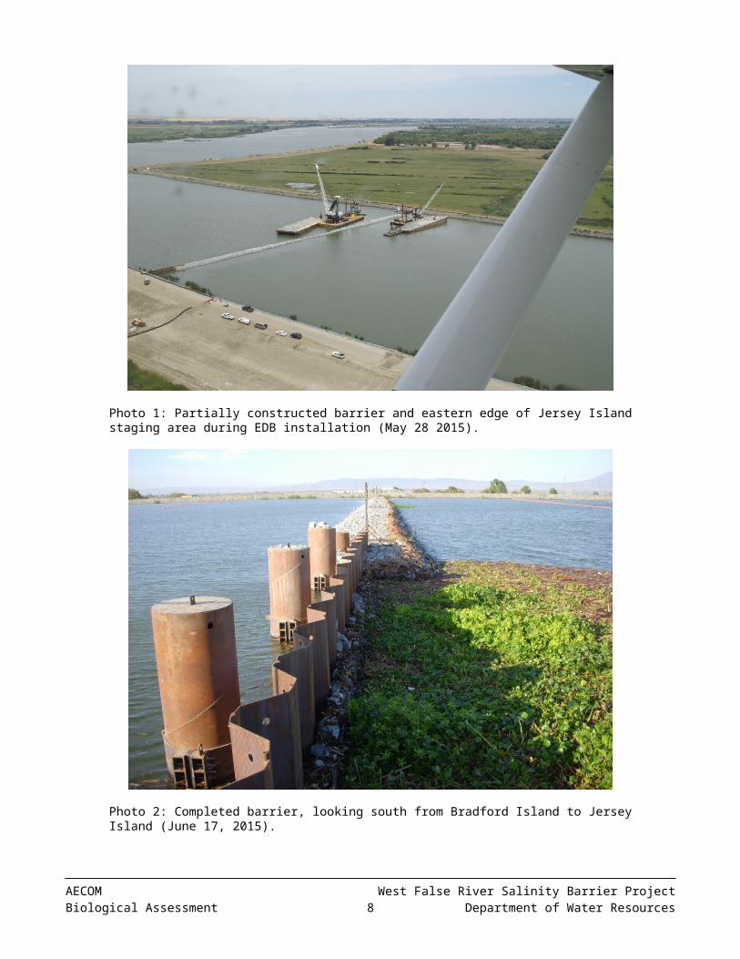
Photo 1: Partially constructed barrier and eastern edge of Jersey Island staging area during EDB installation (May 28 2015).
Photo 2: Completed barrier, looking south from Bradford Island to Jersey Island (June 17, 2015).
Figure 3. Photographs of the Project Site
AECOM West False River Salinity Barrier ProjectBiological Assessment 6 Department of Water Resources
4.2.2 SCHEDULE
Construction activities, including mobilization, would begin no sooner than April 1, 2016. Based on the installation of the EDB in 2015, placement of embankment rock would occur on a 24-hour basis for approximately 45 working days. The construction crew size for installation is assumed to be a maximum of 21 people.
4.2.3 CONSTRUCTION METHODOLOGY
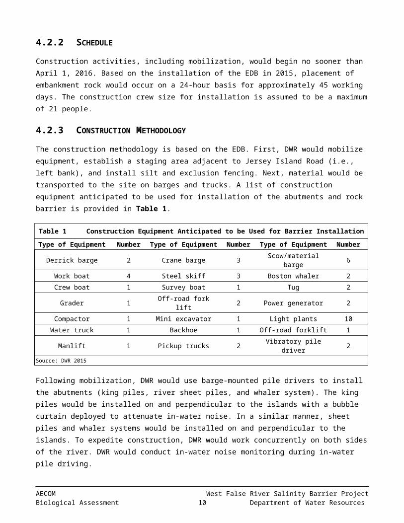
The construction methodology is based on the EDB. First, DWR would mobilize equipment, establish a staging area adjacent to Jersey Island Road (i.e., left bank), and install silt and exclusion fencing. Next, material would be transported to the site on barges and trucks. A list of construction equipment anticipated to be used for installation of the abutments and rock barrier is provided in Table 1.
Table 1 Construction Equipment Anticipated to be Used for Barrier InstallationType of Equipment Number Type of Equipment Number Type of Equipment Number
Derrick barge 2 Crane barge 3 Scow/material barge 6Work boat 4 Steel skiff 3 Boston whaler 2Crew boat 1 Survey boat 1 Tug 2
Grader 1 Off-road fork lift 2 Power generator 2Compactor 1 Mini excavator 1 Light plants 10Water truck 1 Backhoe 1 Off-road forklift 1
Manlift 1 Pickup trucks 2 Vibratory pile driver 2Source: DWR 2015
Following mobilization, DWR would use barge-mounted pile drivers to install the abutments (king piles, river sheet piles, and whaler system). The king piles would be installed on and perpendicular to the islands with a bubble curtain deployed to attenuate in-water noise. In a similar manner, sheet piles and whaler systems would be installed on and perpendicular to the islands. To expedite construction, DWR would work concurrently on both sides of the river. DWR would conduct in-water noise monitoring during in-water pile driving.
Concurrent with abutment installation, DWR would begin placing rock into West False River with a dump scow. Embankment rock would be shipped on barges from either an approved quarry or DWR’s Rio Vista stockpile. In a uniform manner to prevent levee scour, rock would be dumped near the levees and then into the center of the river. Because of fluctuations in water level and the increased streambed elevation, DWR would only be able to use the dump scow for a limited duration. With barge-mounted cranes using clam-shelled and dragline buckets, DWR would shape the rock into a trapezoid and fill the center of the barrier.
Following installation, DWR would demobilize from the site, conduct minor regrading activities, and place soil stabilization on upland disturbance areas.
4.2.4 FISH MOVEMENT AND NAVIGATION
The WFRSB would not be designed to allow fish passage. Fish movement can occur through the adjacent San Joaquin River and through other channels, including Fisherman’s Cut, East False River, and Dutch Slough during the West False River closure.
West False River Salinity Barrier Project AECOMDepartment of Water Resources 7 Biological Assessment

Vessel traffic would be blocked at the WFRSB, but alternative routes are available via the Stockton Deep Water Ship Channel in the San Joaquin River between Antioch and eastern Delta locations, or via Fisherman’s Cut or East False River to South Delta destinations. DWR would install signs on each side of the barrier, float lines with orange ball floats across the width of the channel to deter boaters from approaching the barrier, and solar-powered warning buoys with flashing lights on the barrier crest to prevent accidents during nighttime hours. DWR would also post signs at upstream and downstream entrances to the waterway or other key locations, informing boaters of the restricted access. Navigation signage would comply with requirements set forth by the U.S. Aids to Navigation System and the California Waterway Marker System, as appropriate. DWR would coordinate with the U.S. Coast Guard District 11 and California Division of Boating and Waterways regarding safe vessel passage procedures. DWR or the contractor would post a Notice to Mariners, which would include information on the duration of channel closure, and provide copies to marinas throughout the Delta.
4.2.5 OPERATIONS AND MAINTENANCE
There are no operational features associated with either the WFRSB or abutments. Given the temporary nature of the WFRSB, maintenance would be minimal or nonexistent; however, DWR would regularly inspect the WFRSB during operation and inform the permitting agencies (CDFW, USFWS, and NMFS) if any major maintenance activities are required.
4.3 BARRIER REMOVAL
4.3.1 SCHEDULE
The embankment rock would be removed no later than November 15, 2016. Late November coincides with the start of the rainy season when freshwater runoff typically occurs and flood risk increases. Initial ground disturbance activities, such as mobilization and installation of silt and exclusion fencing, would occur in September to inhibit giant garter snake from entering the construction work area. Given the volume of embankment rock, DWR anticipates excavation would occur continuously (i.e., 24 hours per day, 7 days per week) for up to 90 days. The construction crew size for removal is assumed to be a maximum of 21 people.
4.3.2 GENERAL CONSTRUCTION METHODOLOGY
The methodology described herein is general. Although removal activities would primarily be situated in-water, work would also occur from the levees.
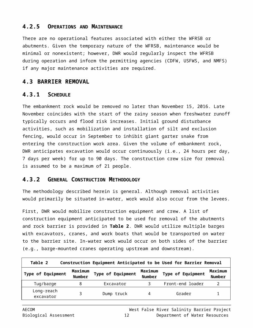
First, DWR would mobilize construction equipment and crew. A list of construction equipment anticipated to be used for removal of the abutments and rock barrier is provided in Table 2. DWR would utilize multiple barges with excavators, cranes, and work boats that would be transported on water to the barrier site. In-water work would occur on both sides of the barrier (e.g., barge-mounted cranes operating upstream and downstream).
Table 2 Construction Equipment Anticipated to be Used for Barrier Removal
Type of Equipment Maximum Number Type of Equipment Maximum
Number Type of Equipment Maximum Number
Tug/barge 8 Excavator 3 Front-end loader 2Long-reach excavator 3 Dump truck 4 Grader 1
Work boat 2 Dozer 1
AECOM West False River Salinity Barrier ProjectBiological Assessment 8 Department of Water Resources

Source: DWR 2015
Next, DWR would strategically place the barges adjacent to the barrier in order to excavate the rock. Barge-mounted cranes with clam-shell or dragline buckets and/or excavators would excavate the rock and place it on another barge. To prevent levee scour, rock removal would begin at the center of the channel and work toward the levees. Excavation would occur from the top of the barrier down to approximate pre-project streambed contours. DWR would restore the levee geometry to ensure compliance with any local maintaining agency or USACE requirements. DWR would conduct bathymetric surveys during and immediately after, barrier removal to confirm all of the rock has been removed.
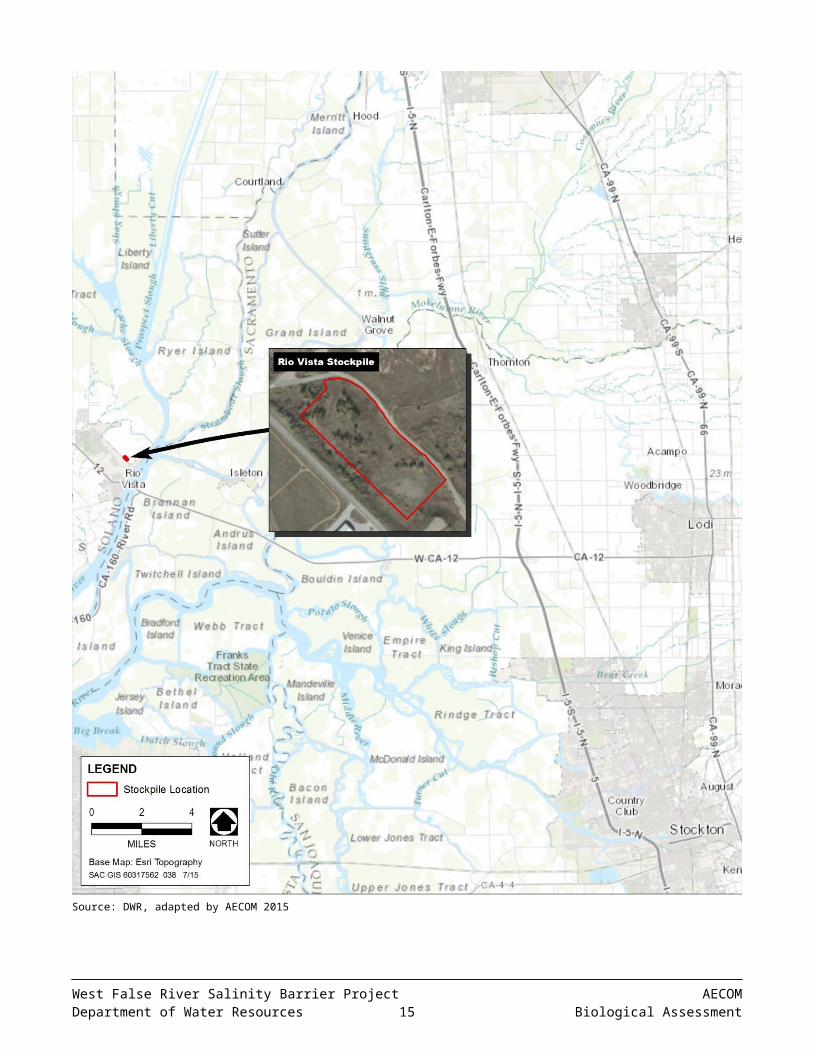
DWR would transport the rock on a barge from the project site to the off-loading site, where it would be transferred onto dump trucks using conveyors, excavators and loaders and then hauled to DWR’s Rio Vista stockpile location (outside of waters of the United States), which is depicted in Figure 4. DWR upgraded the stockpile site in summer 2015 as part of the DWR Delta Flood Emergency Facilities Improvement Project. Alternatively, the rock may be retained by the contractor and stored/used in accordance with their own separate permits and approvals.
Upon removal of the rock barrier, DWR would remove the abutments, buoy piles, buoys, and signs. Divers would remove the abutments and buoy piles by cutting the structures approximately two feet below the original riverbed grade. Because the buoys and signs are anchored by concrete blocks, DWR would completely remove these structures by barge-mounted cranes. The contractor would be required to retain or properly dispose of these materials.
Disturbed upland areas would be restored after the barrier is completely removed. The affected areas would be restored to approximate pre-project conditions and revegetated (e.g., hydroseeding) as appropriate. Any levee access roads that are damaged as a result of construction equipment or truck use would be restored to pre-construction conditions or better after construction is completed.
5 CONSERVATION MEASURES
DWR would implement a number of conservation measures as part of the proposed action to avoid and minimize potential effects on giant garter snake and federally listed fish species.
1. PREPARE AND IMPLEMENT AN EROSION CONTROL PLAN
An Erosion Control Plan will be prepared before beginning construction activities that will cause ground disturbance. Site-specific erosion-control, spill-prevention, sedimentation control, and runoff measures will be
West False River Salinity Barrier Project AECOMDepartment of Water Resources 9 Biological Assessment
Source: DWR, adapted by AECOM 2015
Figure 4. Stockpile Location
AECOM West False River Salinity Barrier ProjectBiological Assessment 10 Department of Water Resources
developed and implemented during construction activities as part of the plan to minimize the potential for erosion and sedimentation during barrier construction and removal.
If applicable, tightly woven fiber netting (mesh size less than 0.25 inch) or similar material will be used for erosion control and other purposes at the project site to ensure wildlife does not become trapped or entangled in the erosion control material. Coconut coir matting is an acceptable erosion control material, but no plastic mono- filament matting will be used for erosion control. If feasible, the edge of the material will be buried in the ground to prevent wildlife from crawling underneath the material.
2. PREPARE AND IMPLEMENT A SPILL PREVENTION AND CONTROL PROGRAM
A spill prevention and control program will be prepared before the start of construction to minimize the potential for hazardous, toxic, or petroleum substances to be released into the project area during construction and operation. The program will be implemented during construction. In addition, DWR will place sand bags, biologs, or other containment features around the areas used for fueling or other uses of hazardous materials to ensure that these materials do not accidentally leak into the river. DWR will adhere to the standard construction best management practices described in the current California Department of Transportation Construction Site Best Management Practices Manual (California Department of Transportation 2003).
The spill prevention and control program will include procedures for mitigating potential spills caused by collision/stranding of vessel traffic with the barrier during its operation. Spill control materials will be kept at the barrier site and at additional DWR-owned locations in the Delta. The barrier will have clear signage with telephone contact details for DWR personnel as well as the Governor’s Office of Emergency Services (CalOES) hazardous materials (HAZMAT) spill notifications contact number (1-800-852-7550).
3. PREPARE AND IMPLEMENT A HAZARDOUS MATERIALS MANAGEMENT PROGRAM
A Hazardous Materials Management Program (HMMP) will be prepared and implemented to identify the hazardous materials to be used during construction; describe measures to prevent, control, and minimize the spillage of hazardous substances; describe transport, storage, and disposal procedures for these substances; and outline procedures to be followed in case of a spill of a hazardous material. The HMMP will require that hazardous and potentially hazardous substances stored onsite be kept in securely closed containers located away from drainage courses, storm drains, and areas where stormwater is allowed to infiltrate. It will also stipulate procedures to minimize hazard during onsite fueling and servicing of construction equipment. Finally, the HMMP will require that adjacent land uses be notified immediately of any substantial spill or release.
4. CONDUCT A WORKER ENVIRONMENTAL AWARENESS PROGRAM
Construction workers will participate in a worker environmental awareness program that addresses species under jurisdiction of the permitting agencies (CDFW, USFWS, and NMFS). Workers will be informed about the potential presence of listed and other protected species, and habitats associated with such species, and that unlawful take of the species or destruction of their habitat is a violation of the federal ESA, California Endangered Species Act (CESA), and/or Migratory Bird Treaty Act. Before the start of construction activities, a qualified biologist approved by the permitting agencies will instruct all construction workers about the life histories of the protected species and the terms and conditions of the applicable Biological Opinions (BOs), CESA Incidental Take Permit (ITP), and other regulatory permits that include biological resource protection measures. Proof of this instruction will be submitted to the permitting agencies.
West False River Salinity Barrier Project AECOMDepartment of Water Resources 11 Biological Assessment
5. CONDUCT BIOLOGICAL MONITORING
A qualified biologist approved by the permitting agencies will be onsite when daytime construction occurs to conduct compliance inspections and monitoring during barrier installation and removal. The qualifications of the biologist(s) will be presented to the permitting agencies for review and approval before beginning project activities at the project site. The complete set of permitting documents will be onsite during construction. The biologist(s) will be given the authority to stop work that may result in, or in the event that there is, take of listed species in excess of limits provided by the permitting agencies in any permitting document (BOs, CESA ITP). If the biologist(s) exercise(s) this authority, the permitting agencies will be notified by telephone and electronic mail within 1 working day.
A report of daily records from monitoring activities and observations will be prepared and provided to the permitting agencies upon completion of project activities.
6. CONDUCT REAL-TIME MONITORING AND ADJUST CONSTRUCTION ACTIVITIES ACCORDINGLY
DWR will monitor weather patterns and river forecasts for the period preceding the start of construction. If precipitation events or increases in river levels and flows are predicted to occur immediately before the start of construction, DWR will notify NMFS, USFWS, and CDFW before the start of construction and informally will confer with them to determine whether construction actions are still feasible as previously considered. Sudden increases in river flows, imminent precipitation events that create changes in river stage in the Sacramento and San Joaquin valleys, or observed sudden increases in turbidity in the Sacramento or San Joaquin rivers upstream of the Delta may initiate pulses of fish migration into the project channels (e.g., juvenile salmonids moving downstream, pre-spawning delta smelt moving upstream).
DWR also will monitor the capture of listed fishes in the fish monitoring programs currently being employed in and close to the barrier site, (i.e., at the nearest Interagency Ecological Program monitoring stations). If increasing presence of listed fishes (principally juvenile salmonids and smelts) is detected in these monitoring efforts during project implementation, DWR will immediately contact NMFS, USFWS, and CDFW to allow informal consultation to determine whether construction actions will place fish at substantial additional risk near the barrier site.
7. CONDUCT PILE DRIVING WITH A VIBRATORY DRIVER TO THE EXTENT POSSIBLE; MINIMIZE EFFECTS OF IMPACT DRIVING
DWR will conduct pile driving using a vibratory hammer to minimize to the extent possible the noise generated from pile-driving activities. NMFS (2015: 50) noted in the Biological Opinion for the Woodward Island Bridge Project over Middle River that only the driving of piles with an impact hammer is expected to produce sound levels that could result in injury to fish, so the use of a vibratory hammer for the West False River salinity barrier abutments substantially reduces or avoids the potential to cause take of listed species. However, in certain circumstances (e.g., vibratory driving is not capable of reaching required embedment), impact pile driving may be necessary. If impact pile driving is necessary, bubble curtains will be employed to attenuate noise. Monitoring of underwater sound generated by the impact hammer during pile driving in the vicinity of the West False River barrier will be conducted to verify that sound level criteria are not being exceeded, i.e., 183-decibel sound exposure level (SEL) at 10 meters from pile driving. If levels are exceeded, the permitting fish agencies will be notified and work halted until corrective actions are instituted to achieve sound level criteria. Sound monitoring is
AECOM West False River Salinity Barrier ProjectBiological Assessment 12 Department of Water Resources
not proposed for vibratory pile driving because there are no accepted threshold criteria for vibratory pile driving (Pearson-Meyer, pers. comm.) and because use of proposed criteria (Hastings 2010) would essentially not result in any restrictions in pile driving on a daily basis (the cumulative SEL would be very high).
8. INSTALL IN-WATER NAVIGATIONAL BUOYS, LIGHTS, AND SIGNAGE
Navigational buoys, lights, and signage will be installed in West False River upstream and downstream from the West False River salinity barrier, to advise boaters about the presence of the emergency salinity barrier and maintain navigation along both waterways. Temporary floating signs and buoys will be anchored to the bottom with cables and concrete anchor blocks. DWR will coordinate with the U.S. Coast Guard on signage and buoys.
9. IMPLEMENT TURBIDITY MONITORING DURING CONSTRUCTION
DWR will monitor turbidity levels in West False River during ground-disturbing activities, including placement of rock fill material and any major maintenance. Monitoring will be conducted by measuring upstream and downstream of the disturbance area to ensure compliance with the Water Quality Control Plan (Basin Plan) for the Sacramento River and San Joaquin River Basins (Central Valley Regional Water Quality Control Board 2011). For Delta waters, the general objectives for turbidity apply except during periods of stormwater runoff; the turbidity of Delta waters shall not exceed 150 Nephelometric Turbidity Units. Exceptions to the Delta specific objectives are considered when a dredging operation can cause an increase in turbidity. In this case, an allowable zone of dilution within which turbidity in excess of limits can be tolerated will be defined for the operation and prescribed in a discharge permit.
DWR contractors will slow or adjust work to ensure that turbidity levels do not exceed those conditions described in the 401 certification issued by the SWRCB. If slowing or adjusting work to lower turbidity levels is not practical or if thresholds cannot be met, DWR will consult with the SWRCB and permitting agencies to determine the most appropriate measures to minimize turbidity impacts to the maximum extent feasible.
10. DEVELOP AND IMPLEMENT A WATER QUALITY MONITORING PLAN
DWR will develop and implement a water quality monitoring plan to assess the effects of the proposed project on flow and water quality throughout the Delta. Monitoring data will be provided by strategically placed stations installed as part of the EDB project. DWR also may use data from other existing and recently upgraded stations throughout the Delta.
DWR will monitor flow, stage, water velocity, water temperature, specific conductance, turbidity, chlorophyll, nutrients, bromide, and organic carbon, pH, and dissolved oxygen. DWR staff will post weekly water quality data summaries of the continuous data. Chlorophyll and nutrient data will be posted online as soon as the results are available.
The water quality monitoring plan will document the procedures for producing the following elements:
► Water quality data from monitoring sites;► Weekly water quality summaries;► Chlorophyll and nutrient data (discrete data) summaries as soon as the results are available;► Final report on project effects on water quality.
West False River Salinity Barrier Project AECOMDepartment of Water Resources 13 Biological Assessment
11. LIMIT HABITAT DISTURBANCE, RETURN DISTURBED AREAS TO PRE-PROJECT CONDITIONS, AND PROVIDE MITIGATION HABITAT
DWR and its construction contractors will strive to limit habitat disturbance during project-related construction activities. Immediately following barrier removal, DWR will restore habitat to approximate pre-project conditions.
DWR will provide mitigation through a mitigation bank approved by USFWS and CDFW at a 1:1 ratio for temporary (less than 1 year) impacts on shallow water habitat associated with the barrier rock.
DWR will provide mitigation through purchase of 1 acre of giant garter snake habitat at a mitigation bank approved by USFWS and CDFW for temporary impacts on giant garter snake.
12. LIMIT LAND-BASED ACCESS ROUTES AND CONSTRUCTION AREA
The number of land-based access routes and size of the construction area will be limited to the minimum area necessary. Access routes will be restricted to established roadways. Construction area boundaries will be clearly demarcated.
13. IMPLEMENT PROTOCOLS FOR GIANT GARTER SNAKE
In addition to applicable measures described above, the following protocols will be implemented in order to avoid and minimize potential impacts to giant garter snakes that may be present on or adjacent to the project site.
► DWR will follow, as practicably as possible, the 1997 Programmatic Formal Consultation for U.S. Army Corps of Engineers 404 Permitted Projects with Relatively Small Effects on the Giant Garter Snake within Butte, Colusa, Glenn, Fresno, Merced, Sacramento, San Joaquin, Solano, Stanislaus, Sutter and Yolo Counties, California (Programmatic BO) (USFWS 1997).
► DWR will coordinate with USFWS and CDFW regarding details and implementation of upland restoration activities and will refer to restoration guidelines provided in Appendix A of the Programmatic BO.
► Barrier removal activities will begin before October 1 to minimize potential for snakes to seek aestivation habitat within the project footprint (including on or near access roads) during barrier removal and upland restoration.
► Before barrier installation and removal activities begin, exclusion fencing, placed a minimum of 6-8 inches below ground, will be installed along the landside edge of the construction/staging areas. The appropriate location for the fencing will be determined by a qualified biologist and indicated to the construction contractor. Fencing materials and installation specifications will be determined in coordination with USFWS and CDFW. The fencing will remain in place throughout the duration of barrier installation and removal, will be inspected daily when project activities are underway, and will be fully maintained. The fencing will be removed after barrier installation activities are complete and will be re-installed before barrier removal activities begin. After barrier removal activities are complete, all fencing materials will be removed and the area will be returned to pre-project conditions.
► The project site will be surveyed for giant garter snakes by a qualified biologist within 24 hours before barrier installation activities (including fencing installation and equipment and material staging) begin. Surveys will
AECOM West False River Salinity Barrier ProjectBiological Assessment 14 Department of Water Resources
be repeated before barrier removal activities begin and if a lapse in project activities of 2 weeks or greater occurs. In addition, the site will be inspected by a biological monitor before installation/removal activities begin each day.
► All project-related vehicle speeds on unpaved roads will be limited to 15 miles per hour.
► Through best management practices all attempts will be made to cause no harm or harassment of giant garter snake. If a giant garter snake is encountered within the construction zone, activities will cease until appropriate corrective measures have been completed or it has been determined that the snake will not be harmed.
► The biologist will notify USFWS and CDFW immediately if a giant garter snake is found onsite, and will submit a report, including date(s), location(s), habitat description, and any corrective measures taken to protect the snake.
14. MINIMIZE WILDLIFE ATTRACTION
To eliminate attraction of wildlife to the project site, all food-related trash items, such as wrappers, cans, bottles, and food scraps, will be disposed of in closed containers and removed from the site on a daily basis.
15. REMOVE INVASIVE SPECIES
DWR will coordinate with the California Department of Parks and Recreation Division of Boating and Waterways Aquatic Weed Control Program for the control of invasive water hyacinth, Brazilian elodea (Egeria densa) or other invasive water weeds covered by the control program in the vicinity of the barrier while the barrier is in place. As needed, the Division of Boating and Waterways will conduct herbicide treatments to control water hyacinth that may result from in changes flow from installation of the barrier. DWR will coordinate with the Division of Boating and Waterways on removal strategies for water hyacinth or other covered invasive water weeds as necessary to assure that the barrier does not exacerbate current aquatic invasive weed problems.
6 ACTION AREA
The action area is defined as all areas to be affected directly or indirectly by the federal action and not merely the immediate area involved in the action (50 CFR § 402.02). For the purposes of this biological assessment, the primary action area includes the WFRSB footprint, including the upland staging areas. A 200-foot buffer surrounding the area of upland disturbance is also included to incorporate any suitable habitat for giant garter snake that could be adversely affected by installation and removal of the barrier. The action area also includes the Rio Vista stockpile area. Appendix B includes photographs of the action area that were taken before and after EDB installation.
7 LIFE HISTORY
Giant garter snakes inhabit marshes, sloughs, ponds, small lakes, low gradient streams and other waterways and agricultural wetlands. They are inactive or greatly reduce their activities during the late fall and winter months,
West False River Salinity Barrier Project AECOMDepartment of Water Resources 15 Biological Assessment

typically emerging from winter retreats in late March to early April and often remaining active through October. The timing of their annual activities is subject to varying seasonal weather conditions. Giant garter snakes feed on small fishes, tadpoles, and frogs (Hansen 1988). They breed in March and April, with females giving birth to live young from late July though early September (Hansen and Hansen 1990).
Suitable giant garter snake habitat is characterized by all of the features necessary to support permanent populations of the species, including: (1) adequate water during the snake’s active season, (2) emergent herbaceous wetland vegetation for escape and foraging habitat, (3) grassy banks and openings in waterside vegetation for basking, and (4) higher elevation upland habitat for cover and refuge from flooding (USFWS 2012). Occupied aquatic habitats typically contain permanent or seasonal water, mud bottoms, and vegetated dirt banks (Hansen and Brode 1980).
The width of uplands used by giant garter snake varies considerably. Many summer basking and refuge areas used by this snake are immediately adjacent to canals and other aquatic habitats, and may even be located in the upper canal banks. While this species is strongly associated with aquatic habitats, individuals have been noted using burrows as far as 165 feet from marsh edges during the active season and retreats more than 820 feet from the edge of wetland habitats while overwintering (Wylie et al. 1997, USFWS 1999). Therefore, land within this further distance may be important for snake survival in some cases (Hansen 1988).
8 ENVIRONMENTAL BASELINE
The environmental baseline “includes the past and present impacts of all federal, state, or private actions and other human activities in the action area, the anticipated impacts of all proposed federal projects in the action area that have already undergone formal or early Section 7 consultation, and the impact of state or private actions which are contemporaneous with the consultation in process” (50 CFR §402.02).
8.1 STATUS OF THE SPECIES IN THE ACTION AREA
Information regarding the status of giant garter snake in the action area is based on observations made during reconnaissance-level and pre-construction field surveys conducted before EDB installation began in May 2015, observations made during biological monitoring of barrier installation, California Natural Diversity Database (CNDDB) occurrence records, and information presented in the Bay Delta Conservation Plan (DWR 2013). Reconnaissance-level surveys were conducted on March 14, 2014 and April 14, 2015; pre-construction surveys were conducted on April 21 and 29 and May 4, 2015; and construction monitoring was conducted May 5 through June 17, 2015.
A large portion of the Delta has not been comprehensively surveyed for giant garter snake, primarily because the majority of land is privately owned. Historical and more recent focused surveys failed to confirm extant population clusters in the region (Hansen 1986; Patterson 2003, 2005; Patterson and Hansen 2004), including during DWR surveys of various Delta locations in 2009. However, individuals have been trapped at White Slough Wildlife Area and several photographed near Little Connection Slough (USFWS 2012). More recent observations have been made at additional locations in the vicinity of Little Connection Slough and farther south in the Delta. These suggest viable populations of giant garter snake may persist in the eastern portion of the Delta.
AECOM West False River Salinity Barrier ProjectBiological Assessment 16 Department of Water Resources
Several observations of giant garter snake also have been documented in the vicinity of the project site in recent years. The CNDDB includes three recent observations of giant garter snakes in the vicinity of the EDB site: a 2002 observation near the ferry dock at the southwestern corner of Webb Tract, approximately 1.5 miles east of the site; a 2010 observation on the south side of Sherman Island, approximately 5 miles southwest of the site; and a 2014 observation on the landside slope of the south levee of Webb Tract, approximately 2.5 miles east of the site. Two older occurrences are also documented in the CNDDB, a 1998 observation approximately 3.5 miles northwest of the site and a pre-1986 specimen collected in the vicinity of the 2010 observation.
In 2003 and 2004, focused surveys for giant garter snake were conducted on the Webb Tract, but no individuals were documented. The surveyors concluded that though the island provided habitat and had the potential to support a giant garter snake population, such a population didn’t appear to exist (USFWS 2006). The origin of giant garter snakes documented in the vicinity of the project site in recent years is uncertain, and observations in the central Delta have typically been considered to be of snakes that occasionally move into the region by ‘washing-down’ from known populations and that these occurrences do not represent local breeding populations (USFWS 2006; Hansen, pers. comm., in DWR 2013). As a result, Little Connection Slough has been thought to represent the most western Delta location where the species regularly exists (USFWS 2012). However, this assumption is being reconsidered, because the frequency of observations in the area has increased in recent years, potentially indicating a permanent population may be present, despite previous negative survey results.
The potential presence of a permanent population of giant garter snakes in the vicinity of the project site was further supported by observations made in April and May 2015, during activities associated with EDB installation. Confirmed observations of the species were made on 7 days between April 21 and May 21, and four unconfirmed observations were made during the same period. These include observations made on or immediately adjacent to the project site (on Jersey and Bradford islands), and while traveling between the Jersey Island ferry dock and the site.
The stockpile site at Rio Vista does not support suitable aquatic habitat for giant garter snake, and no suitable aquatic habitat is present within 200 feet (DWR 2015). Therefore, the species is unlikely to occur on or near the stockpile site, and use of the site is not discussed further in this biological assessment.
8.2 FACTORS AFFECTING THE SPECIES AND HABITAT IN THE ACTION AREA
A number of factors have and continue to affect giant garter snake throughout its range. The primary cause of giant garter snake decline throughout its current and former ranges has been attributed to aquatic habitat loss. The most serious current threats to the species are loss and fragmentation of habitat from both urban and agricultural development and potential loss of habitat associated with changes in rice production (USFWS 2012). Activities such as water management and water transfers that result in habitat loss are also of particular concern. Secondary threats include introduced predators, road construction, and erosion control. Based on review of historic aerial photography, habitat in the action area has changed little in the past 20 years. However, if giant garter snakes are present in the area, they could suffer adverse effects from agricultural and pastoral activities, levee maintenance and repair, and vehicle mortality.
Ongoing, recent, and planned future project known from within or nearby the action area for terrestrial species include the various activities associated with EDB installation in May-July 2015 and EDB removal and geologic exploration proposed to be conducted in September-November 2015. In 2014, a seepage berm was constructed by
West False River Salinity Barrier Project AECOMDepartment of Water Resources 17 Biological Assessment
the local Reclamation District as part of the Delta Levee Special Flood Control Projects Program. The berm is landside of the Jersey Island levee and overlaps the project site. In addition, the Reclamation District conducted geotechnical borings on and at the toe of the berm in May 2015, during EDB installation.
9 EFFECTS ASSESSMENT
This section describes the potential effects of implementing the proposed action on giant garter snake.
9.1.1 EFFECTS OF WFRSB INSTALLATION
Figure 2 shows the area that would be impacted during WFRSB installation activities, including: installation of the abutments and barrier rock fill, staging activities, and general construction-related disturbance. Appendix B includes photographs of the project site and adjacent areas during EDB installation in 2015.
Initial project activities, including mobilization and pile driving, would occur during daylight hours, but barrier rock placement would occur on a 24-hour basis. Although nighttime work would increase the amount of disturbance within a given 24-hour period, it would reduce the number of days required for barrier installation and would be restricted to in-water work that has minimal potential for adverse effects on giant garter snake. Approximately 2.49 acres of aquatic habitat in the river would be temporarily filled by placement of barrier rock across most of the channel. King and sheet piles would fill a very narrow area across the remaining approximately 150 feet of the channel, between the barrier rock and the levees (see Figure 3, Photo 2).
The river provides only marginally suitable aquatic habitat, because giant garter snakes are generally absent from large rivers, but it is likely used as a movement corridor between areas of suitable habitat on the islands. It is unlikely, however, that individuals would be directly affected by in-water placement of transition and barrier rock, because they would be able to leave and/or avoid the area of disturbance.
Up to 1.95 acres of upland habitat would be disturbed by activities in upland portions of the project site. Because most project activity would be in-water, the intensity of upland disturbance would be relatively minor and primarily limited to some staging of equipment and materials and general disturbance associated with movement of equipment, materials, and construction and monitoring personnel. Upland disturbance would be limited to the crown of both levees and the seepage berm that was constructed landside of the Jersey Island levee in 2014. The very small area of sub-surface ground disturbance would be limited to the approximately 5 feet of sheet pile that would extend into the water side of each levee.
Because soils on the project site were graded and compacted during the recent seepage berm construction and additional ground disturbance is associated with EDB installation and removal, the site is very unlikely to currently provide underground refuge for giant garter snake. Therefore, although pile driving could occur during the snake’s inactive season, potential for individuals to be present underground where the sheet piles would penetrate several feet into the levee is very low. However, observations of giant garter snakes made just prior to and during EDB installation indicate they are likely to occur aboveground in the action area during WFRSB installation.
Applicable measures described in Section 5, “Conservation Measures” would be implemented to avoid and minimize potential adverse effects on giant garter snake during WFRSB installation activities. Based on results of
AECOM West False River Salinity Barrier ProjectBiological Assessment 18 Department of Water Resources
biological monitoring conducted during EDB installation, these measures are anticipated to be effective in minimizing adverse effects on aquatic habitat in the river and avoiding direct contact of giant garter snakes with project-related equipment, vehicles, supplies, and personnel. No mortality or physical harm of giant garter snake was documented during EDB installation and none is expected to occur during WFRSB installation. However, take of giant garter snake could result from harassment of snakes that flush from the area as a result of project disturbance. In addition, if an individual is repeatedly observed in the same location and determined to be particularly vulnerable to harassment, injury, or death, it may be appropriate to relocate it to an area farther from the project site.
9.1.2 EFFECTS OF WFRSB OPERATION
Because there are no operational features associated with the barrier or abutments, no adverse effects on giant garter snake are anticipated to occur during WFRSB operation. If unanticipated maintenance of the abutments and/or barrier is required, disturbance associated with such maintenance activities would likely be minimal. Conservation measures described in Section 5 also would be implemented during any maintenance activities to minimize potential for adverse effects.
Although presence of the barrier rock temporarily reduces the amount of aquatic habitat in the river, the barrier does not hinder movement of giant garter snake and would have a minimal effect on the overall amount and quality of the aquatic habitat for giant garter snake.
9.1.3 EFFECTS OF WFRSB REMOVAL
Potential effects of WFRSB removal on giant garter snake would be similar to those described above for installation. The same area of aquatic habitat that would be affected during installation would be disturbed by removing the barrier and abutments. Upland disturbance would be limited to access by construction and monitoring personnel and vehicles and some staging of equipment and materials.
As during WFRSB installation, giant garter snakes are likely to be present in areas adjacent to the site during removal activities. Conservation measures described in Section 5 also would be implemented during removal of the barrier and abutments. Implementing the conservation measures would minimize potential for giant garter snakes to access the project site and come in contact with personnel, vehicles, equipment, and materials. The measures are anticipated to be effective in avoiding direct injury or death of snakes. However, based on the number of observations of giant garter snake made during EDB installation, individuals may be displaced or otherwise disturbed by WFRSB removal activities, including potential capture and relocation if individuals are observed repeatedly on the project site in an area where they could be injured or killed by project activities.
10 CUMULATIVE EFFECTS
Under the federal ESA, cumulative effects are those effects of future state, tribal, local, or private actions that are reasonably certain to occur within the action area of the federal action subject to consultation (50 Code of Federal Regulations 402.2). Future federal actions that are unrelated to the proposed action are not considered in this assessment because they require separate consultation under Section 7 of the ESA.
West False River Salinity Barrier Project AECOMDepartment of Water Resources 19 Biological Assessment
No future non-federal projects that are reasonably certain to occur in the action area for terrestrial species are known at this time. Reclamation District activities may be under consideration but are not known at this time, and routine agricultural activities and other private landowner actions are likely to be ongoing in the action area. All of these potential future activities could alter habitat for and/or increase incidental take of giant garter snake and would be cumulative to the effects of the proposed action.
11 CONCLUSION
It is concluded that the proposed action may affect and is likely to adversely affect giant garter snake. Implementation of the conservation measures would minimize take of giant garter snake during WFRSB installation, operation, and removal. No individuals are likely to be injured or killed as a result of the proposed action and other forms of take (i.e., capture and harassment) are anticipated to affect a small number of individuals. Therefore, the proposed action would not jeopardize the continued existence of giant garter snake.
12 REFERENCES
California Department of Water Resources. 2013. Bay Delta Conservation Plan. Public Draft. November. Sacramento, CA. Prepared by ICF International (ICF 00343.12). Sacramento, CA.
———. 2015. Record of Field Activity conducted by Gabrielle Bohrer and Kip Young on June 19, 2015 at the Rio Vista transfer facility.
Central Valley Regional Water Quality Control Board. 2011 (October). Water Quality Control Plan (Basin Plan) for the Sacramento River and San Joaquin River Basins. Fourth edition. Sacramento, CA.
DWR. See California Department of Water Resources.
Hansen, G. E. 1986. Status of the Giant Garter Snake Thamnophis couchii gigas (Fitch) in the Southern Sacramento Valley During 1986. Final report for the California Department of Fish and Game, Standard Agreement No. C-1433.
———. 1988. Review of the Status of the Giant Garter Snake (Thamnophis couchii gigas) and its Supporting Habitat during 1986–87. Final report for the California Department of Fish and Game, Contract C-2060. Unpublished. 31 pp.
Hansen, G. E., and J. M. Brode. 1980. Status of the Giant Garter Snake Thamnophis couchii gigas (Fitch). Inland Fisheries Endangered Species Special Publication 80(5):1–14. California Department of Fish and Game, Sacramento, CA.
Hansen, R.W. and G.E. Hansen. 1990. Thamnophis gigas. Reproduction. Herpetological Review 21(4):93-94.
Hastings, M.C. 2010. Recommendations for Interim Criteria for Vibratory Pile Driving. Submitted to ICF Jones and Stokes. June 30.
AECOM West False River Salinity Barrier ProjectBiological Assessment 20 Department of Water Resources
National Marine Fisheries Service. 2015. Endangered Species Act Section 7(a)(2) Biological Opinion, Magnuson-Stevens Fishery Conservation and Management Act Essential Fish Habitat Response, and Fish and Wildlife Coordination Act Recommendations for the Woodward Island Bridge Project (Ferry Ramp Replacement) over Middle River in western San Joaquin County. June 24. West Coast Region. Sacramento, CA.
NMFS. See National Marine Fisheries Service.
Patterson, L. 2003. Giant Garter Snake Surveys for the In-Delta Storage Program. Year End and Summary Report. Sacramento, CA: California Department of Water Resources.
———. 2005. Giant Garter Snake Surveys for the In-Delta Storage Program. Year End and Summary Report. Sacramento, CA: California Department of Water Resources.
Patterson, L. and E. Hansen. 2004. Giant Garter Snake Surveys on Bacon Island and Webb Tract and Re-evaluation of Habitat Quality in 2003. Sacramento, CA: California Department of Water Resources.
Pearson-Meyer, Jacqueline. Fishery Biologist – California Fish Hydroacoustics Coordinator. NOAA Fisheries West Coast Region, CA. May 18, 2015—email to Marin Greenwood, Aquatic Ecologist, ICF International, Sacramento, CA.
U.S. Fish and Wildlife Service. 1997. Programmatic Formal Consultation for U.S. Army Corps of Engineers 404 Permitted Projects with Relatively Small Effects on the Giant Garter Snake within Butte, Colusa, Glenn, Fresno, Merced, Sacramento, San Joaquin, Solano, Stanislaus, Sutter and Yolo Counties, California. (November 13). Sacramento Fish and Wildlife Office. Sacramento, CA.
———. 1999. Draft Recovery Plan for the Giant Garter Snake (Thamnophis gigas). U.S. Fish and Wildlife Service, Portland, Oregon. Ix + 192 pp.
———. 2006. Giant Garter Snake (Thamnophis gigas) 5-Year Review: Summary and Evaluation. Sacramento Fish and Wildlife Office. Sacramento, CA.
———. 2012. Giant Garter Snake (Thamnophis gigas) 5-Year Review: Summary and Evaluation. Sacramento Fish and Wildlife Office. Sacramento, CA.
USFWS. See U.S. Fish and Wildlife Service.
Wylie, G. D. and M. Amarello. 2007. Surveys for the current distribution and abundance of giant garter snakes (Thamnophis gigas) in the southern San Joaquin Valley. Prepared for the Bureau of Reclamation by the U. S. Geological Survey, Biological Resources Division, Dixon Field Station, Dixon, California.
Wylie, G. D., M. L. Casazza, and J. K. Daugherty. 1997. 1996 progress report for the giant garter snake study. Unpublished (preliminary) report. U.S. Geological Survey, Biological Resources Division, Dixon Field Station, Dixon, California. May 1, 1997. 6 pp. + Figures.
West False River Salinity Barrier Project AECOMDepartment of Water Resources 21 Biological Assessment
This page intentionally left blank.
AECOM West False River Salinity Barrier ProjectBiological Assessment 22 Department of Water Resources
APPENDIX AUSFWS Species List

West False River Salinity Barrier Project AECOMDepartment of Water Resources A-1 Biological Assessment

AECOM West False River Salinity Barrier ProjectBiological Assessment A-2 Department of Water Resources
West False River Salinity Barrier Project AECOMDepartment of Water Resources A-3 Biological Assessment
AECOM West False River Salinity Barrier ProjectBiological Assessment A-4 Department of Water Resources
West False River Salinity Barrier Project AECOMDepartment of Water Resources A-5 Biological Assessment
AECOM West False River Salinity Barrier ProjectBiological Assessment A-6 Department of Water Resources
West False River Salinity Barrier Project AECOMDepartment of Water Resources A-7 Biological Assessment

APPENDIX BPhotographs of the Action Area

Photo 1: Looking west along the Jersey Island levee crown, before EDB installation (April 14, 2015).
Photo 2: Looking south at the staging area on Jersey Island, before EDB installation (April 14, 2015).
Appendix B Photographs of the Action Area
West False River Salinity Barrier Project AECOMDepartment of Water Resources B-1 Biological Assessment

Photo 3: Looking west along the Bradford Island levee crown, before EDB installation (April 14, 2015).
Photo 4: Looking northwest from the Bradford Island levee crown, before EDB installation (April 14, 2015).
Appendix B Photographs of the Action Area
AECOM West False River Salinity Barrier ProjectBiological Assessment B-2 Department of Water Resources
Photo 5: Looking west on Bradford Island levee road, after barrier installation (June 17, 2015).
Photo 9: Looking east on Jersey Island levee road, with barrier on left (June 17, 2015).
Appendix B Photographs of the Action Area
West False River Salinity Barrier Project AECOMDepartment of Water Resources B-3 Biological Assessment