Mi-HUNT Cov er Typ s€¦Echo Lake Bob Lake Penegor Lake 1 1 1 1 1 1 1 1 1 1 1 1 1 1 2 2 2 2 2 2 2 2...
1
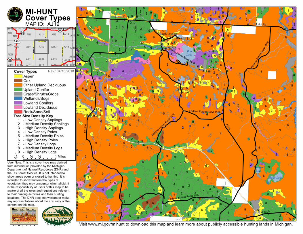
Echo Lake Bob Lake Penegor Lake 1 1 1 1 1 1 1 1 1 1 1 1 1 1 2 2 2 2 2 2 2 2 2 2 2 2 2 2 2 2 2 2 2 2 2 2 2 2 2 2 2 2 2 2 2 2 2 3 3 3 3 3 3 3 3 3 3 3 3 3 3 3 3 3 3 3 3 3 3 3 3 3 3 3 3 3 3 3 3 3 3 3 3 3 3 3 3 3 3 3 3 3 3 3 3 3 3 3 3 3 3 3 3 3 3 3 3 3 3 3 3 3 3 3 3 3 3 3 3 3 3 3 3 3 3 3 3 3 3 3 3 3 3 3 3 3 3 3 3 3 3 3 3 3 3 3 3 3 3 3 3 3 3 3 3 3 3 3 3 3 3 3 3 3 4 4 4 4 4 4 4 4 4 4 4 4 5 5 5 5 5 5 5 5 5 5 5 5 5 5 5 5 5 5 5 5 5 5 5 5 5 5 5 5 5 5 5 5 5 5 5 5 5 5 5 5 5 5 5 5 5 5 5 6 6 6 6 6 6 6 6 6 6 6 6 6 6 6 6 6 6 6 6 6 6 6 6 6 6 6 6 6 6 6 6 6 6 6 6 6 6 6 6 6 6 6 6 6 6 6 6 6 6 6 6 6 6 6 6 6 6 6 6 6 6 6 6 6 6 6 6 6 6 6 6 6 6 6 6 6 6 6 6 6 6 6 6 6 6 6 6 6 6 6 6 6 6 6 6 6 6 6 6 6 6 6 6 6 6 6 6 6 6 6 6 6 6 6 6 6 6 6 6 6 6 6 6 6 6 6 6 6 6 6 6 6 6 6 6 6 6 6 6 6 6 6 6 6 6 6 6 6 6 6 6 6 6 6 6 6 6 6 6 6 6 6 6 6 6 6 6 6 6 6 6 6 6 6 6 6 6 6 6 6 6 6 6 6 6 6 6 6 6 6 6 6 6 6 6 6 6 6 6 6 6 6 6 6 6 6 6 6 7 7 7 7 8 8 8 8 8 8 8 8 8 8 8 8 8 8 8 8 8 8 8 8 8 9 9 9 9 9 9 9 9 9 9 9 9 9 9 9 9 9 9 9 9 9 9 9 9 9 9 9 9 9 9 9 9 9 9 9 9 9 9 9 9 9 9 9 9 9 9 9 9 9 9 9 9 9 9 9 9 9 9 9 9 9 9 9 9 9 9 9 9 9 9 9 9 9 9 9 9 9 9 9 9 9 9 9 9 9 9 9 9 9 9 9 9 9 9 9 9 9 9 9 9 9 9 9 9 9 9 9 9 9 9 9 9 9 9 9 9 9 9 9 9 9 9 9 9 9 9 9 9 9 9 9 9 9 9 9 9 9 9 9 9 9 9 9 9 9 9 9 9 9 9 Federal Forest Road 1470 Federal Forest Road 1478 FF1100 Bob Lake Rd FF16 L137B FF1300 S Laird Rd Pori Rd Federal Forest Road 1460 Federal Forest Road 1500 Federal Forest Road 1619 Visit www.mi.gov/mihunt to download this map and learn more about publicly accessible hunting lands in Michigan. User Note: This is a cover type map derived from information provided by the Michigan Department of Natural Resources (DNR) and the US Forest Service. It is not intended to show areas open or closed to hunting. It is intended to show hunters the types of vegetation they may encounter when afield. It is the responsibility of users of this map to be aware of all the rules and regulations relevant to their hunting activities and their hunting locations. The DNR does not warrant or make any representations about the accuracy of the content on this map. Mi-HUNT Cover Types MAP ID: AJ12 Cover Types Aspen Oak Other Upland Deciduous Upland Conifer Grass/Shrubs/Crops Wetlands/Bogs Lowland Conifers Lowland Deciduous Rock/Sand/Soil 0 ½ 1 ¼ Miles Tree Size Density Key 1 - Low Density Saplings 2 - Medium Density Saplings 3 - High Density Saplings 4 - Low Density Poles 5 - Medium Density Poles 6 - High Density Poles 7 - Low Density Logs 8 - Medium Density Logs 9 - High Density Logs Rev.: 04/16/2018 38 28 26 45 AL09 AL10 AL11 AL12 AL13 AL14 AL15 AK09 AK10 AK11 AK12 AK13 AK14 AK15 AJ09 AJ10 AJ11 AJ12 AJ13 AJ14 AJ15 AI09 AI10 AI11 AI12 AI13 AI14 AI15 AH09 AH11 AH12 AH13 AH14 AH15
Transcript of Mi-HUNT Cov er Typ s€¦Echo Lake Bob Lake Penegor Lake 1 1 1 1 1 1 1 1 1 1 1 1 1 1 2 2 2 2 2 2 2 2...
Echo Lake
BobLake
PenegorLake
1
1
11
1
1
1
1
1
11
1 1
1
2
2
2
2
2 2
2
2
2
2
22
22
2
2
2
222
2
22
2
2
22
2
222
22
3 333
3333
33
3
3
33
3
33
3333 3
3 33333
33
33 333
3
3 3333
3
33
3
3 3
3 3333 3
333
3 333 33
3
3
3
3
333
3
3
3
3
3
3
333
3
33
333
3
3
3
33
3 33
33
3 3
3333 3
3
33
33
33 3
3
33
33
333
4
4
4
44
4
4
4
4
44
4
555
5
5
5
5
5
5
55
5 55 5
5
5
5
5
5
5
5
5
5
5
5
55
5
555
5
555 5555
5
5
5
5 5
55
6666
6 66
6
666
6
6
66
66
6
66
6
66 66
6 6
6
6
6
66
6
6 6666 66 6
6
6
666
66
6 66
66
6
6
6
66
66 6
6
6
6 6
6
66
66 66
6
6 666
6 666666
6 6
66
6 66
66
6 666 6
66
66
666
6
66
6
666 6
66
6
6 66
6
6
6
6
6 6
666
66
6
6 6 66
6
66
6 6
6
6 66
6
6 6
6
6
66
666
66
66 66
6
6
6 66 66
66 66
6 66 6
6
66 6
666
6
66
6
66
6
66 6
666 6
66 66 66
6
6
6
6 6 6
6
7
7
7
7
8
8
8
8
88
8
8
8
8
88
8 8
88 8 8
8
88
9
9 9
99
9 999
99
999
99
99
9 9
9 9
9
99
9
9
99
9
9 9 999
99 99
99
9
999
9
9
9 9
99
9 99
9999
9
9
9
9
9 9
9
9 999
9
99 9
99 99 9
99
99
9 99
9
99
999
9 99
9
9
9
9
99
9
99
9 9
9 9
999 99
9
99
99
9
9
9
99
9
9 9 99 9
999
9 9
99
9
999
9 9
9
99
9
9
9 999
Federal Forest Road 14
70
Federal Forest Road 1478
FF11
00
Bob Lake Rd
FF16
L137B
FF1300
S Laird RdPori Rd
Federal Forest Road 1460
Fede
ral Fo
rest R
oad 15
00
Federal Forest Road 1619
Visit www.mi.gov/mihunt to download this map and learn more about publicly accessible hunting lands in Michigan.
User Note: This is a cover type map derivedfrom information provided by the Michigan Department of Natural Resources (DNR) and the US Forest Service. It is not intended to show areas open or closed to hunting. It is intended to show hunters the types of vegetation they may encounter when afield. It is the responsibility of users of this map to be aware of all the rules and regulations relevant to their hunting activities and their hunting locations. The DNR does not warrant or make any representations about the accuracy of the content on this map.
Mi-HUNTCover TypesMAP ID: AJ12
Cover TypesAspenOakOther Upland DeciduousUpland ConiferGrass/Shrubs/CropsWetlands/BogsLowland ConifersLowland DeciduousRock/Sand/Soil
0 ½ 1¼ Miles
Tree Size Density Key 1 - Low Density Saplings 2 - Medium Density Saplings 3 - High Density Saplings 4 - Low Density Poles 5 - Medium Density Poles 6 - High Density Poles 7 - Low Density Logs 8 - Medium Density Logs 9 - High Density Logs
Rev.: 04/16/2018
38
28
26
45
AL09 AL10 AL11 AL12 AL13 AL14 AL15
AK09AK10 AK11 AK12 AK13 AK14
AK15
AJ09 AJ10 AJ11 AJ12 AJ13 AJ14 AJ15
AI09AI10 AI11 AI12 AI13 AI14 AI15
AH09 AH11 AH12 AH13 AH14 AH15


![[XLS] · Web view3 1 3 1 3 1 3 1 3 1 3 1 4 2 4 2 3 1 3 1 4 1 3 1 4 1 3 1 4 1 3 1 5 3 4 1 7 3 7 3 4 3 5 3 8 2 3 2 8 2 8 1 4 3 4 2 4 3 6 3 4 2 4 2 6 2 4 3 3 1 4 2 6 3 8 3 5 3 6 2 4 1](https://static.fdocuments.net/doc/165x107/5abb7c477f8b9a24028cb350/xls-view3-1-3-1-3-1-3-1-3-1-3-1-4-2-4-2-3-1-3-1-4-1-3-1-4-1-3-1-4-1-3-1-5-3-4.jpg)