METROPOLITAN DEVELOPMENT COMMISSION PLAT …€¦ · 2011-PLT-006 4900 NORTH CARROLL ROAD 10...
30
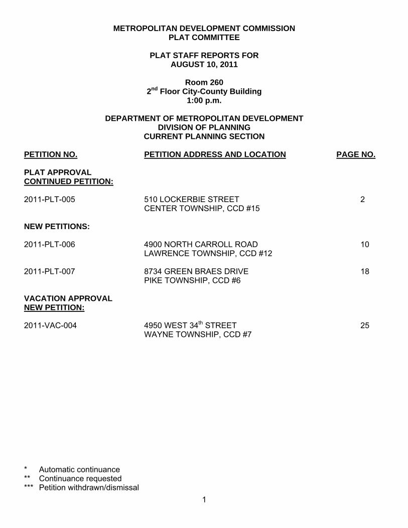
1 METROPOLITAN DEVELOPMENT COMMISSION PLAT COMMITTEE PLAT STAFF REPORTS FOR AUGUST 10, 2011 Room 260 2 nd Floor City-County Building 1:00 p.m. DEPARTMENT OF METROPOLITAN DEVELOPMENT DIVISION OF PLANNING CURRENT PLANNING SECTION PETITION NO. PETITION ADDRESS AND LOCATION PAGE NO. PLAT APPROVAL CONTINUED PETITION: 2011-PLT-005 510 LOCKERBIE STREET 2 CENTER TOWNSHIP, CCD #15 NEW PETITIONS: 2011-PLT-006 4900 NORTH CARROLL ROAD 10 LAWRENCE TOWNSHIP, CCD #12 2011-PLT-007 8734 GREEN BRAES DRIVE 18 PIKE TOWNSHIP, CCD #6 VACATION APPROVAL NEW PETITION: 2011-VAC-004 4950 WEST 34 th STREET 25 WAYNE TOWNSHIP, CCD #7 * Automatic continuance ** Continuance requested *** Petition withdrawn/dismissal
Transcript of METROPOLITAN DEVELOPMENT COMMISSION PLAT …€¦ · 2011-PLT-006 4900 NORTH CARROLL ROAD 10...
1
METROPOLITAN DEVELOPMENT COMMISSION PLAT COMMITTEE
PLAT STAFF REPORTS FOR
AUGUST 10, 2011
Room 260 2nd Floor City-County Building
1:00 p.m.
DEPARTMENT OF METROPOLITAN DEVELOPMENT DIVISION OF PLANNING
CURRENT PLANNING SECTION PETITION NO. PETITION ADDRESS AND LOCATION PAGE NO. PLAT APPROVAL CONTINUED PETITION: 2011-PLT-005 510 LOCKERBIE STREET 2 CENTER TOWNSHIP, CCD #15 NEW PETITIONS: 2011-PLT-006 4900 NORTH CARROLL ROAD 10 LAWRENCE TOWNSHIP, CCD #12 2011-PLT-007 8734 GREEN BRAES DRIVE 18 PIKE TOWNSHIP, CCD #6 VACATION APPROVAL NEW PETITION: 2011-VAC-004 4950 WEST 34th STREET 25 WAYNE TOWNSHIP, CCD #7 * Automatic continuance ** Continuance requested *** Petition withdrawn/dismissal
2
STAFF REPORT
Department of Metropolitan Development Division of Planning
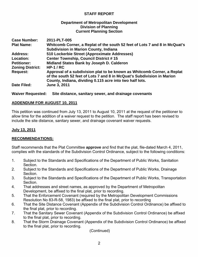
Current Planning Section Case Number: 2011-PLT-005 Plat Name: Whitcomb Corner, a Replat of the south 52 feet of Lots 7 and 8 in McQuat’s
Subdivision in Marion County, Indiana Address: 510 Lockerbie Street (Approximate Addresses) Location: Center Township, Council District # 15 Petitioner: Midland States Bank by Joseph D. Calderon Zoning District: HP-1 / RC Request: Approval of a subdivision plat to be known as Whitcomb Corner, a Replat
of the south 52 feet of Lots 7 and 8 in McQuat’s Subdivision in Marion County, Indiana, dividing 0.115 acre into two half lots.
Date Filed: June 3, 2011 Waiver Requested: Site distance, sanitary sewer, and drainage covenants ADDENDUM FOR AUGUST 10, 2011 This petition was continued from July 13, 2011 to August 10, 2011 at the request of the petitioner to allow time for the addition of a waiver request to the petition. The staff report has been revised to include the site distance, sanitary sewer, and drainage covenant waiver requests. July 13, 2011 RECOMMENDATIONS: Staff recommends that the Plat Committee approve and find that the plat, file-dated March 4, 2011, complies with the standards of the Subdivision Control Ordinance, subject to the following conditions: 1. Subject to the Standards and Specifications of the Department of Public Works, Sanitation
Section. 2. Subject to the Standards and Specifications of the Department of Public Works, Drainage
Section. 3. Subject to the Standards and Specifications of the Department of Public Works, Transportation
Section. 4. That addresses and street names, as approved by the Department of Metropolitan
Development, be affixed to the final plat, prior to recording. 5. That the Enforcement Covenant (required by the Metropolitan Development Commissions
Resolution No 83-R-58, 1983) be affixed to the final plat, prior to recording 6. That the Site Distance Covenant (Appendix of the Subdivision Control Ordinance) be affixed to
the final plat, prior to recording. 7. That the Sanitary Sewer Covenant (Appendix of the Subdivision Control Ordinance) be affixed
to the final plat, prior to recording. 8. That the Storm Drainage Covenant (Appendix of the Subdivision Control Ordinance) be affixed
to the final plat, prior to recording. (Continued)

3
STAFF REPORT 2011-PLT-005 (Continued) 9. That the plat restrictions and covenants, done in accordance with the rezoning commitments,
be submitted, prior to recording the final plat. 10. That all the standards related to secondary plat approval listed in Sections 731-320(b)(6) and
731-329 of the Subdivision Control Ordinance are met. 11. Lots One and Two shall not be individually developed with detached single-family dwellings. SUMMARY OF ISSUES The following information was considered in formulating the recommendation: LAND USE The subject site is zoned HP-1 and developed with a two-family dwelling on a 5,009-square foot
lot, the south 52 feet of Lots 7 and 8 in McQuat’s Subdivision in Marion County, Indiana; the dwelling is oriented to and has 52 feet of frontage on East Street, as well as 96 feet of frontage on Lockerbie Street with alley access. This orientation is not consistent with the originally platted dimensions of the property although it is consistent with the development pattern of the neighborhood.
The site was developed with the existing two-family dwelling circa 1876. In 1976, the structure
was approved as a combination office and residence for the Phi Kappa Psi Fraternity as permitted by 76-AP-131. The attached garages were added to the rear of the dwellings in 2007 with the approval of IHPC COA: 07-403 (LS).
SITE PLAN This proposed plat would divide the existing parcel into two half lots with the lot lines following the
common wall of the two-family dwelling and continuing through the rear yards. The half lots would have widths of between 23.79 feet and 28.21 feet. This replat would allow the property owner to individually sell the duplex units with minimal impact on the surrounding property owners.
TRAFFIC / STREETS No new streets are proposed with this plat. The proposed development would have vehicular
access from the first north/south alley east of East Street, with frontage on East Street and Lockerbie Street, existing public streets.
PROCEDURE ◊ This plat petition, if approved, only legally establishes the division of land, related to a two-family
dwelling. In the event that the existing duplex were to be removed, any new construction would be required to meet all development standards of the HP-1, Historic Preservation Districts Ordinance.
(Continued)
STAFF REPORT 2011-PLT-005 (Continued)
4
WAIVER REQUESTS
◊ The petitioner is requesting waivers from the site distance, drainage, and sanitary sewer
covenants. Because the dwelling was constructed significantly prior to the covenant requirements, staff recommends approval of the waiver.
GENERAL INFORMATION EXISTING LAND USE AND ZONING HP-1/ RC Two-family dwelling SURROUNDING ZONING AND LAND USE North - HP-1/RC Two-family residential South - HP-1/RC Single-family residential East - PK-1/RC James Whitcomb Riley’s House West - CBD-2 / Multi-family residential HPS/RC
THOROUGHFARE PLAN The Official Thoroughfare Plan indicates that East Street is a
primary arterial with an existing 90-foot right-of-way and a proposed 90-foot right-of-way. Lockerbie Street is not indicated on the Official Thoroughfare Plan.
ZONING HISTORY 76-AP-131; 331-333 North East Street (subject site), requests variance of use to allow for office and residential uses, approved. IHPC COA: 07-403 (LS); 510 Lockerbie Street (subject site), requests approval to construct a four-car attached garage addition with living space above, approved. ATS ******

5

6

7
Preliminary Plat

8
510 Lockerbie Street as viewed from across East Street
Attached garages at 510 Lockerbie Street

9
Neighboring James Whitcomb Riley house
Multi-family residential west of site

10
Single-family dwelling south of site

11
STAFF REPORT
Department of Metropolitan Development Division of Planning
Current Planning Section Case Number: 2011-PLT-006 Plat Name: The Greens at Winding Ridge, Section Four Address: 4900 North Carroll Road (Approximate Addresses) Location: Lawrence Township, Council District # 12 Petitioner: Evergreen Planners by Arthur L. Kaser Zoning District: D-P Request: Approval of a subdivision plat to be known as The Greens at Winding
Ridge, Section Four, dividing 10.238 acres into 42 lots. Date Filed: June 29, 2011 Waiver Requested: None RECOMMENDATIONS: Staff recommends that the Plat Committee approve and find that the plat, file-dated March 4, 2011, complies with the standards of the Subdivision Control Ordinance, subject to the following conditions: 12. Subject to the Standards and Specifications of the City of Lawrence, Sanitation Section. 13. Subject to the Standards and Specifications of the City of Lawrence, Drainage Section. 14. Subject to the Standards and Specifications of the City of Lawrence, Transportation Section. 15. That addresses and street names, as approved by the Department of Metropolitan
Development, be affixed to the final plat, prior to recording. 16. That the Enforcement Covenant (required by the Metropolitan Development Commissions
Resolution No 83-R-58, 1983) be affixed to the final plat, prior to recording 17. That the Site Distance Covenant (Appendix of the Subdivision Control Ordinance) be affixed to
the final plat, prior to recording. 18. That the Sanitary Sewer Covenant (Appendix of the Subdivision Control Ordinance) be affixed
to the final plat, prior to recording. 19. That the Storm Drainage Covenant (Appendix of the Subdivision Control Ordinance) be affixed
to the final plat, prior to recording. 20. That the plat restrictions and covenants, done in accordance with the rezoning commitments,
be submitted, prior to recording the final plat. 21. That all the standards related to secondary plat approval listed in Sections 731-320(b)(6) and
731-329 of the Subdivision Control Ordinance are met. 22. That a landscape plan for the interior and perimeter area be submitted for Administrator
Approval prior to the secondary approval of the final pat.
SUMMARY OF ISSUES The following information was considered in formulating the recommendation:
Continued)

12
STAFF REPORT 2011-PLT-006 (Continued) SITE PLAN AND DESIGN This proposal would provide for the subdivision of 10.238 acres into 42 lots. The Winding Ridge
community is permitted to have 2,793 total single-family and multifamily units, including the 2,450 units of the original rezoning in 1996, the 225 units added by the rezoning in 2000 (2000-ZON-003) and the 118 units added by the use amendment in 2002 (2002-APP-075). The D-P development statement requires that a summary of platted lots and multifamily units developed be submitted with each plat. This summary has been provided.
TRAFFIC STREETS This site would have access to Carroll Road from the proposed Fawn Crest Drive. This section
would also connect to the existing stub of Greenside Drive, providing access from section two to Carroll Road. The proposed Fawn Crest Drive would to connect to future sections and is going to be left as a stub until the future sections are platted.
GENERAL INFORMATION EXISTING LAND USE AND ZONING DP Vacant DEVELOPMENT STATEMENT The development statement requirements listed below are only applicable to the platting requirements and are not comprehensive. Please refer to the approved development statement associated with rezoning petition 96-Z-124 (96-DP-7), and to the modifications with petitions 97-AP-98 and 99-AP-207. AREA 3 – Development Standards ITEM DEVELOPMENT STATEMENT Use permitted Detached single-family residential Number of acres 67 Number of Lots Not specified Density (maximum) 3.25 units per acre Lot frontage (minimum) 20 feet Front Setback (minimum) 25 feet Side setback (minimum) 14 feet between dwellings Rear setback (minimum) 25 feet
Dwelling size (minimum) 1,200 sq. ft. (one story), 1,500 sq. ft. (two story) Off-street parking spaces Two, attached garage
SURROUNDING ZONING AND LAND USE North - D-P Single-family residential / golf course South - D-P (FF) Single-family residential / golf course East - Hancock County Agricultural Fields West - D-P Single-family residential / golf course
(Continued)
13
STAFF REPORT 2011-PLT-006 (Continued)
THOROUGHFARE PLAN The Official Thoroughfare Plan indicates that Carroll Road is a secondary arterial with an existing 50-foot right-of-way and a proposed 140-foot right-of-way.
ZONING HISTORY 2006-PLT-008; 4950 North Carroll Road (subject site), requests approval of a subdivision plat to be known as The Greens at Winding Ridge, Section Two, dividing 12.52 acres into 50 lots approved. 2002-APP-075; 11808 East 56th Street (north of site), requests modification of development statement, related to 96-Z-124 (96-DP-12), to provide for Sections 14, 15, 16, 17, 18, and 19 of Winding Ridge to be used for attached multi-family dwellings, no more that 225 units, with 1.5 acres of Section 18 designated for the development of a daycare facility, approved. 2000-ZON-003; 11302 East 56th Street (north of site), requests rezoning of 58.0 acres, being in the D-A district, to the D-P classification to provide for single-family residential development, approved. 96-Z-124; 11750, 11501 East 46th Street, and 5201 North German Church Road (subject site), requests rezoning of 857 acres, being in the D-A district, to the D-P classification to provide for the development of a golf course community, approved. ATS ******

14

15
Preliminary Plat

16
Future subdivision entrance from Carroll Road
Existing golf cart path crossing subdivision entrance

17
Looking west from entrance toward future intersection of Fawn Crest Drive and Greenside Drive
Looking north along Greenside Drive into existing development

18
Looking southwest down Fawn Crest Drive

19
STAFF REPORT
Department of Metropolitan Development Division of Planning
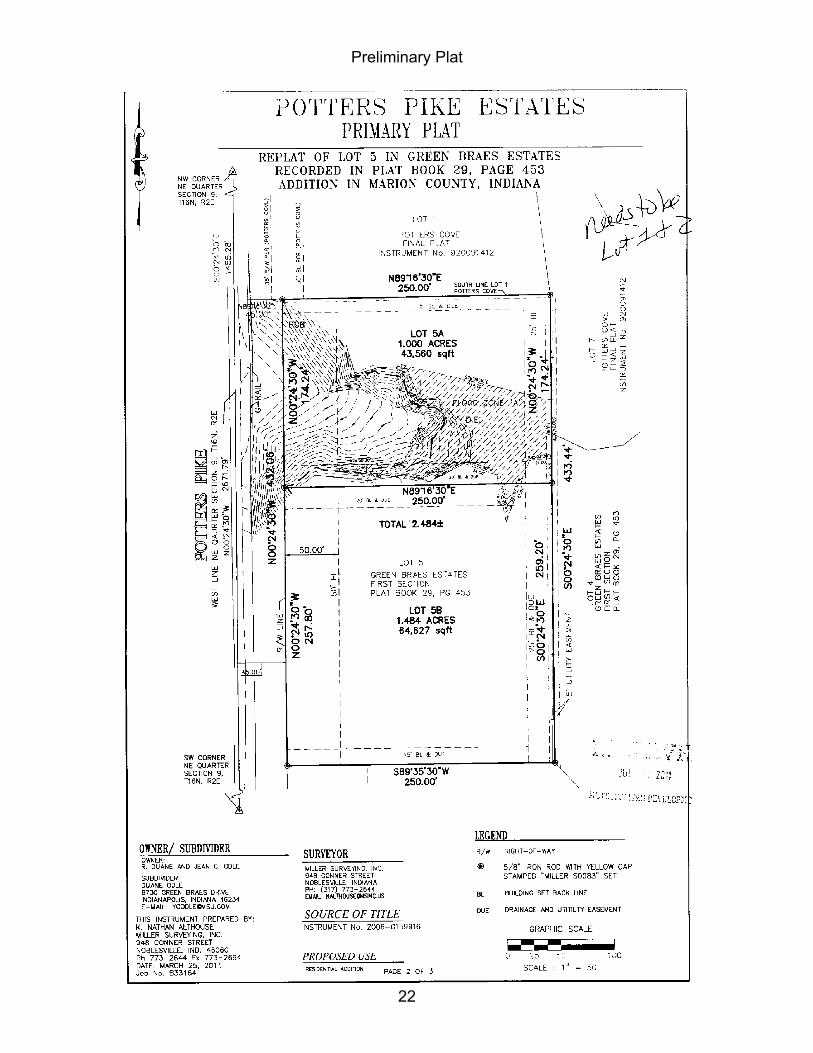
Current Planning Section Case Number: 2011-PLT-007 Plat Name: Potters Pike Estates Address: 8734 Green Braes Drive (Approximate Addresses) Location: Pike Township, Council District # 6 Petitioner: Duane and Jean Odle, by Nathan Althouse Zoning District: D-S Request: Approval of a subdivision plat to be known as Potters Pike Estates,
subdividing 2.5 acres, into two lots, with a waiver of sidewalks. Date Filed: July 1, 2011 Waiver Requested: Sidewalks RECOMMENDATIONS: Staff recommends that the Plat Committee approve and find that the plat, file-dated March 4, 2011, complies with the standards of the Subdivision Control Ordinance, subject to the following conditions: 23. Subject to the Standards and Specifications of the Department of Public Works, Sanitation
Section. 24. Subject to the Standards and Specifications of the Department of Public Works, Drainage
Section. 25. Subject to the Standards and Specifications of the Department of Public Works, Transportation
Section. 26. That addresses and street names, as approved by the Department of Metropolitan
Development, be affixed to the final plat, prior to recording. 27. That the Enforcement Covenant (required by the Metropolitan Development Commissions
Resolution No 83-R-58, 1983) be affixed to the final plat, prior to recording 28. That the Site Distance Covenant (Appendix of the Subdivision Control Ordinance) be affixed to
the final plat, prior to recording. 29. That the Sanitary Sewer Covenant (Appendix of the Subdivision Control Ordinance) be affixed
to the final plat, prior to recording. 30. That the Storm Drainage Covenant (Appendix of the Subdivision Control Ordinance) be affixed
to the final plat, prior to recording. 31. That the plat restrictions and covenants, done in accordance with the rezoning commitments,
be submitted, prior to recording the final plat. 32. That all the standards related to secondary plat approval listed in Sections 731-320(b)(6) and
731-329 of the Subdivision Control Ordinance are met. 33. Lots One and Two shall not be individually developed with detached single-family dwellings. SUMMARY OF ISSUES The following information was considered in formulating the recommendation:
(Continued)

20
STAFF REPORT 2011-PLT-007 (Continued) SITE PLAN This proposed plat would divide the existing parcel into two lots. Both of the lots being created will
meet all of the development standards of the D-S classification.
TRAFFIC / STREETS No new streets are proposed with this plat. The proposed development would have vehicular
access from Potters Pike, an existing public street.
WAIVER OF SIDEWALKS ◊ The petitioner is requesting a waiver from the sidewalk requirements which states that sidewalks
must be installed along all existing perimeter streets. Potters Pike has no existing sidewalks and the topography in the area makes sidewalk installation difficult. Therefore, staff recommends approval of the waiver request.
GENERAL INFORMATION EXISTING LAND USE AND ZONING D-S (FF) Vacant SURROUNDING ZONING AND LAND USE North - D-S Single-family dwelling South - D-S Single-family dwelling East - D-S (FF) Single-family dwellings West - D-S Single-family dwellings
THOROUGHFARE PLAN The Official Thoroughfare Plan indicates that East Street is a
primary arterial with an existing 90-foot right-of-way and a proposed 90-foot right-of-way. Lockerbie Street is not indicated on the Official Thoroughfare Plan.
ZONING HISTORY 69-Z-106; Between West 46th and 56th Streets, Marion-Hendricks County Line Road and along the 815 contour line (United States Government Datum) (subject site), requests rezoning of approximately 520 acres, being in the A-2 and D-S districts, to the D-S classification, approved. 90-V1-17; 6406 Potters Pike (north of site), requests variance of development standards of the Dwelling Districts Zoning Ordinance to permit seven single-family dwellings with less than the required lot frontage an private streets, approved. ATS ******

21
22
Preliminary Plat
23
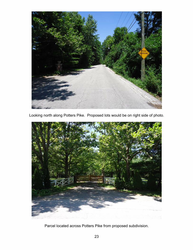
Looking north along Potters Pike. Proposed lots would be on right side of photo.
Parcel located across Potters Pike from proposed subdivision.

24
Topography in the area makes the installation of sidewalks impractical.
General conditions on the site; wooded rolling hills.

25
Low point on the site is at the convergence three gullies.

26
STAFF REPORT
Department of Metropolitan Development Division of Planning
Current Planning Section Case Number: 2011-VAC-004 Address: 4950 West 34th Street (Approximate Address) Location: Wayne Township, Council District # 7 Petitioner: Educational Capital Solutions by SCO Engineering Hearing Date: August 10, 2011 Waivers: None SUMMARY This request would vacate a linear drainage and utility easement which follows the parcel lines left over from the Leo Wright Addition, platted in 1960. The easement runs perpendicular to Auburn Street and stretches beneath the existing building to a point 179 feet to the east. At a point approximately 1/3 of the easement from its eastern end of the easement, a second easement branches off approximately 89 feet to the northwest. The vast majority of the easement lies beneath the existing building and is no longer being used by utilities. Therefore, staff is recommending approval. Staff finds the vacation would be in the public interest and recommends the vacation petition be approved, subject to the release of the easement rights of all utilities listed below. RECOMMENDED MOTION: That the Metropolitan Development Commission find that the proposed vacation is in the public interest; that a hearing upon the assessment of benefits be waived; that the Metropolitan Development Commission confirm and ratify the adoption of Declaratory Resolution 2011-VAC-004, subject to the release of all utility easement rights. GENERAL DESCRIPTION: VACATION of a remnant drainage and utilities easement which lies beneath an existing building.
UTILITIES AND AGENCY REPORT Telephone: No objection, release easement Gas: No objection, release easement Water: No answer, retain easement, if requested Power: No answer, retain easement, if requested Cable: No answer, retain easement, if requested DPR: No answer, retain easement, if requested DPW, SS: No answer, retain easement, if requested DPW, TS: No answer, retain easement, if requested Subject to Utilities? Yes ATS ******

27

28

29
Front of building at 4950 West 34th Street
Western façade of building. Utility easement is located at door with ramp.
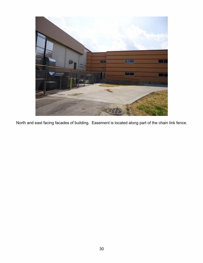
30
North and east facing facades of building. Easement is located along part of the chain link fence.