Methodology of creating a neighborhood where … · Methodology of creating a neighborhood where...
155
Methodology of creating a neighborhood where identity can evolve Applied design scenario in Makiki Caroline Hoshi May 2008 University of Hawai‘i at Mānoa School of Architecture Doctorate Project Committee David Rockwood - Chairperson Geoffrey Lewis Patrick Onishi Submitted towards the fulfillment of the requirements for the Doctor of Architecture Degree.
Transcript of Methodology of creating a neighborhood where … · Methodology of creating a neighborhood where...

Methodology of creating a neighborhood where identity can evolveApplied design scenario in Makiki
Caroline Hoshi
May 2008
University of Hawai‘i at Mānoa
School of Architecture
Doctorate Project Committee
David Rockwood - Chairperson
Geoff rey Lewis
Patrick Onishi
Submitted towards the fulfi llment of the requirements for the Doctor of Architecture Degree.

Acknowledgements
This project has its origin in ideas collected from a number of sources. They are from the classroom,
library, the offi ce, the fi eld, and my own experience. It is an integration of lessons learned, trial
and error, and new discoveries. However, this project is a collective eff ort because it requires the
knowledge and creative thinking of many great individuals. I would like to thank the people who
supported me throughout this project. This project could not have been accomplished without the
input and support of those important people.
I would like to thank my committee who helped and supported this project and who took the time
out of their busy schedules to give me feedback and guidance throughout the process. I especially
thank David Rockwood, my chairperson, who spent countless hours reviewing the document
and discussing ways for improvement. I am truly grateful to Geoff rey Lewis and Patrick Onishi, my
committee, for their knowledgeable guidance and constant encouragement.
There are many others to whom I owe thanks. Foremost among these is Michael Motoda, my boss
at the landscape architecture fi rm where I worked for 4 years during school years. He supported me
in many ways throughout my 4 years of working experience. I am grateful to him for his thoughtful
advice and encouragement.
Lastly, I would like to thank my family and friends who supported and encouraged me throughout
my 7 years of architectural education, especially to my mother who was patient and understanding
even during the diffi cult times.

Table of contents
Chapter 1: Problem statement and Project description
1. Problem statement
Lack of identity
Makiki as a new central urban area
Mixed use
Current land use patterns
Current condition in Makiki
Proposed condition in Makiki
2. Project description
Research
Implementation Strategy - Zoning
Implementation Strategy - Design Guideline
Applied design scenario in Makiki
3. Project site and history
Site
History
Chapter 2: Analysis of the urban characteristics of Makiki
1. Demographics
Gender
Cultural background
Place of Birth
Household type
Units in housing structures
Year built
Household income
Means of transportation to work
1
7
8
17
• • • • • • • • • • • • • • • • • • • • • • • • • • • • • • • • • • • • • • • • • • • • • • • • • • • • • • • • • • •
• • • • • • • • • • • • • • • • • • • • • • • • • • • • • • • • • • • • • • • • • • • • • • • • • • • • • • • • • • •
• • • • • • • • • • • • • • • • • • • • • • • • • • • • • • • • • • • • • • • • • • • • • • • • • • • • • • • •
• • • • • • • • • • • • • • • • • • • • • • • • • • • • • • • • • • • • • • • • • • • • • • • • • • • • • • • • • • • • • • •

2. Site analysis
Benefi ts of the site
Circulation
Density
Sun angle
3. Building forms and streetscape
4. Activities on Wilder Avenue
Makiki Shopping Village
Makiki District Park
Chapter 3: What is Mixed use?
1. Defi nition of mixed use development
2. History of mixed use
3. Diff erent types of mixed use
Vertical mixed use
Town center planned mixed use
Adaptive mixed use
Corridor high-density residential mixed use
Neighborhood mixed use
4. Advantage of mixed use
Diversity
Opportunity
Reduction of dependency upon the automobile
Increase in land use effi ciency
5. Disadvantage of mixed use
24
30
32
34
34
36
45
46
• • • • • • • • • • • • • • • • • • • • • • • • • • • • • • • • • • • • • • • • • • • • • • • • • • • • • • • • • • • • • • • • •
• • • • • • • • • • • • • • • • • • • • • • • • • • • • • • • • • • • • • • • • • • • • • • • •
• • • • • • • • • • • • • • • • • • • • • • • • • • • • • • • • • • • • • • • • • • • • • • • • • • •
• • • • • • • • • • • • • • • • • • • • • • • • • • • • • • • • • • • • • • • • • •
• • • • • • • • • • • • • • • • • • • • • • • • • • • • • • • • • • • • • • • • • • • • • • • • • • • • • • • • •
• • • • • • • • • • • • • • • • • • • • • • • • • • • • • • • • • • • • • • • • • • • • • • • • • •
• • • • • • • • • • • • • • • • • • • • • • • • • • • • • • • • • • • • • • • • • • • • • • • • • • • • • •
• • • • • • • • • • • • • • • • • • • • • • • • • • • • • • • • • • • • • • • • • • • • • • • • • • •

Chapter 4: Case studies of Mixed use and Great Public Places
1. Mixed use: Hillside Terrace - Tokyo, Japan
Background
History
Facades of Hillside Terrace
Facades of surrounding buildings on Old Yamate Street
Transformation of the neighborhood
Spatial Composition in Hillside Terrace
Conclusion
2. Mixed use: Silodam - Amsterdam, The Netherlands
Background
Meeting diff erent needs
Diversity
Spatial experience
Conclusion
3. Great street: Cat Street - Tokyo, Japan
Background
Meandering street
Variety of options
4. Great street: Portobello Road - London, England
Background
History
Portobello Road Market
Unique storefronts
5. Great Community garden: Liz Christy Garden - New York, NY
Background
Accessibility and Comfort
Variety of experience
6. Great Park: Jardin des Plantes - Paris, France
Background
History
Accessibility
Variety of activities
48
53
56
58
60
62
• • • • • • • • • • • • • • • • • • • • • • • • • • • • • • • • • • • • • • •
• • • • • • • • • • • • • • • • • • • • • • • • • • • • • • •
• • • • • • • • • • • • • • • • • • • • • • • • • • • • • • • • • • • • • • • • • • •
• • • • • • • • • • • • • • • • • • • • • • • • • • • • • • • • •
• • • • • • • • • • • • • • • • • • • • • •
• • • • • • • • • • • • • • • • • • • • • • • • • • • • • • • • • • • • •

7. Great Mall: Ala Moana Center - Honolulu, HIBackground
Variety of options
Open-air
Landscape and water feature
Ample seating
8. Great Mall: Waikiki Beach Walk - Honolulu, HI Background
Respecting the culture
9. Great Cafe: Starbucks at Ward - Honolulu, HI Background
The third place
Open hours
Semi-public space and Landscape
10. Great Cafe: Coff ee Line - Honolulu, HI Background
Owner’s pride
Semi-open space
Outdoor seating area
Sharing art and cultures
11. Great Workplace: Paragraph - New York, NY
Background
The space for specifi c needs
12. What makes an identity? Identity of Makiki
Identity of Hillside Terrace - Tokyo, Japan
Identity of Silodam - Amsterdam, The Netherlands
Identity of Cat Street - Tokyo, Japan
Identity of Jardin des Plantes - Paris, France
Identity of Coff ee Line - Honolulu, HI
13. What is learned from the case studies
64
65
66
68
70
71
84
• • • • • • • • • • • • • • • • • • • • • • • • • • • • • • • • • • • • •
• • • • • • • • • • • • • • • • • • • • • • • • • • • • • • • • • • • •
• • • • • • • • • • • • • • • • • • • • • • • • • • • • • • • • • • • • •
• • • • • • • • • • • • • • • • • • • • • • • • • • • • • • • • • • • • • • • • • • •
• • • • • • • • • • • • • • • • • • • • • • • • • • • • • • • • • • • • •
• • • • • • • • • • • • • • • • • • • • • • • • • • • • • • • • • • • • • • • • • • • • • • • • • • • • • •
• • • • • • • • • • • • • • • • • • • • • • • • • • • • • • • • • • • • • • • • • •

Chapter 5: Implementation strategy - Zoning
1. Zoning districtsPurpose and intent of Apartment mixed use district
Purpose and intent of Business mixed use district
AMX is suitable for a neighborhood like Makiki
2. Existing maximum building area and densityLot area: less than 10,000 s.f. (Example lot area: 8,000 s.f.)
Lot area: 10,000 to 20,000 s.f. (Example lot area: 15,000 s.f.)
Lot area: 20,000 to 40,000 s.f. (Example lot area: 30,000 s.f.)
Lot area: over 40,000 s.f. (Example lot area: 50,000 s.f.)
AMX-2 and AMX-3 are suitable for a neighborhood like Makiki
Constraints of existing maximum building area and density
3. Existing parking requirementLot area: less than 10,000 s.f. (Example lot area: 8,000 s.f.)
Lot area: 10,000 to 20,000 s.f. (Example lot area: 15,000 s.f.)
Lot area: 20,000 to 40,000 s.f. (Example lot area: 30,000 s.f.)
Lot area: over 40,000 s.f. (Example lot area: 50,000 s.f.)
Constraints of existing parking requirement
Parking requirement could be reduced by the new transit system
Maximizing the building area
4. Height requlation and setbackExample 1: Maximum height = 40 feet
Example 2: Maximum height = 40 feet
Example 3: Maximum height = 60 feet
Example 4: Maximum height = 60 feet
Height setback
• • • • • • • • • • • • • • • • • • • • • • • • • • • • • • • • • • • • • • • • • • • • • • • • • • • • • • • • • • • • • •
• • • • • • • • • • • • • • • • • • • • • • • • • • • • • • • • • • • •
• • • • • • • • • • • • • • • • • • • • • • • • • • • • • • • • • • • • • • • • • • • • • • • • • •
• • • • • • • • • • • • • • • • • • • • • • • • • • • • • • • • • • • • • • • • • • • • • • • • •
85
87
91
99

Chapter 6: Implementation strategy - Design Guideline
1. Introducing mixed use
2. Introducing secondary feeder system
3. Parcel consolidationWhen parcel consolidation is not possible
4. ParkingAmount and Location
On-street parking
Off -street parking
5. Cultural DiversityCultural events and farmers market
Public space that fosters cultural diversity
6. Diversity of architectural styles and building typesDiversity of architectural styles
Diversity of building types
7. LandscapeStreet trees
Ornamental plants
Groundcovers
8. StorefrontGood design makes mixed use corridors stronger
Entrance
Windows and display
Lighting
Signage and colors
Overhangs
Unique facades
104
105
106
108
111
114
116
121
• • • • • • • • • • • • • • • • • • • • • • • • • • • • • • • • • • • • • • • • • • • • • • • • • • • • • • •
• • • • • • • • • • • • • • • • • • • • • • • • • • • • • • • • • • • • • • • • • •
• • • • • • • • • • • • • • • • • • • • • • • • • • • • • • • • • • • • • • • • • • • • • • • • • • • • • • • • •
• • • • • • • • • • • • • • • • • • • • • • • • • • • • • • • • • • • • • • • • • • • • • • • • • • • • • • • • • • • • • • • • • • • •
• • • • • • • • • • • • • • • • • • • • • • • • • • • • • • • • • • • • • • • • • • • • • • • • • • • • • • • • • • • •
• • • • • • • • • • • • • • • • • • • • • • • • • • • • • • •
• • • • • • • • • • • • • • • • • • • • • • • • • • • • • • • • • • • • • • • • • • • • • • • • • • • • • • • • • • • • • • • • •
• • • • • • • • • • • • • • • • • • • • • • • • • • • • • • • • • • • • • • • • • • • • • • • • • • • • • • • • • • • • • • • • • •

Chapter 7: Applied design scenario in Makiki
1. Introducing mixed use: Corridor high-density residential mixed use
2. Secondary feeder system
3. Zoning change
4. Parcel consolidationExisting narrow parcels along Wilder Avenue
Parcel consolidation
When parcel consolidation is not possible
5. Zoning modifi cationExisting maximum heights in Makiki
Maximum building area, density and heights in AMX-2 zone
Maximum building area, density and heights in AMX-3 zone
Benefi ts of height setback
6. ParkingAmount and Location
Parking structure at the node
7. Public space
8. Diversity of architectural styles and building types
9. LandscapeStreet trees
Landscape for public space
10. Storefront
11. ConclusionEvolving identity over applied identity
This project is a starting point
128
129
131
132
134
138
140
141
142
144
145
• • • • • • • • • • • • • • •
• • • • • • • • • • • • • • • • • • • • • • • • • • • • • • • • • • • • • • • • • • • • • • • • • • • •
• • • • • • • • • • • • • • • • • • • • • • • • • • • • • • • • • • • • • • • • • • • • • • • • • • • • • • • • • • • • •
• • • • • • • • • • • • • • • • • • • • • • • • • • • • • • • • • • • • • • • • • • • • • • • • • • • • • • • • •
• • • • • • • • • • • • • • • • • • • • • • • • • • • • • • • • • • • • • • • • • • • • • • • • • • • • • • • • •
• • • • • • • • • • • • • • • • • • • • • • • • • • • • • • • • • • • • • • • • • • • • • • • • • • • • • • • • • • • • • • • • • • • •
• • • • • • • • • • • • • • • • • • • • • • • • • • • • • • • • • • • • • • • • • • • • • • • • • • • • • • • • • • • • • • • •
• • • • • • • • • • • • • • • • • • • • • • • • • • • • • •
• • • • • • • • • • • • • • • • • • • • • • • • • • • • • • • • • • • • • • • • • • • • • • • • • • • • • • • • • • • • • • • • •
• • • • • • • • • • • • • • • • • • • • • • • • • • • • • • • • • • • • • • • • • • • • • • • • • • • • • • • • • • • • • • • • • •
• • • • • • • • • • • • • • • • • • • • • • • • • • • • • • • • • • • • • • • • • • • • • • • • • • • • • • • • • • • • • • • • •

References
Malcolm Gladwell: The Tipping Point, Little Brown, Boston, c2002
James Gonser: Urban challenges confront Makiki, Honolulu Advertiser, January 9, 2005
Barrie B. Greenbie: Design for Diversity, Elsevier Scientifi c Publishing Company, New York, 1976
Cy Paumier: Creating a Vibrant City Center, Urban Land Institute, Washington, D.C., 2004
Timothy Beatley: Green Urbanism - Learning from European Cities, Island Press, Washington D.C., 2000
Hoaliku L. Drake: Neighborhood Data Book - Pensacola/Makiki, The offi ce of Human Resources, City
and County of Honolulu, Honolulu, HI, 1980
Harry Wiland and Dale Bell: Edens Lost & Found, Chelsea Green Publishing Company, White River
Junction, VT, 2006
Richard Register: Ecocities- building cities in balance with nature, Berkeley Hills Books, Berkeley, CA,
2002
Esther Charlesworth: City Edge- Case Studies in Contemporary Urbanism, Architectural Press, An imprint
of Elsevier, Burlington, MA, 2005
Dan Chiras and Dave Wann: Superbia!, New Society Publishers, Canada, 2003
Nicholas R. Fyfe: Images of the Street, Routledge, London, 1998
Mike Jenks and Nicola Dempsey: Future Forms and Design for Sustainable Cities, Architectural Press,
An imprint of Elsevier, Burlington, MA, 2005
John Ormsbee Simonds: Garden cities 21 - Creating a livable urban environment, McGraw-Hill, Inc.,
New York, 1994
Allan B. Jacobs: Great Streets, The MIT Press, Cambridge, Massachusetts, 1993
Peter Katz: The New Urbanism - Toward and Architecture of Community, McGraw-Hill, Inc., New York,
1994
Robert Kronenburg: Flexible - Architecture that Responds to Change, Laurence King Publishing, London,
2007

Matthew P. Murgio: Communication Graphics, Van Nostrand Reinhold Company, New York, NY, 1969
Edward R. Tufte: Envisioning Information, Graphics Press, Cheshire, Connecticut, 1990
Edward R. Tufte: Visual Explanation, Graphics Press, Cheshire, Connecticut, 1990
Ruth Eaton: Ideal Cities - Utopianism and the (Un) Built Environment, Thames & Hudson, London, 2002
Philip Thiel: People, Path, and Purposes - Notations for a Participatory Envirotecture, University of
Washington Press, Seattle, WA, 1996
Edward B. Scott: The Saga of the Sandwitch Islands, Sierra-Tahoe Publishing Co. Lake Tahoe, NV, 1968
Historic Building Task Force: Old Honolulu - A guide to Oahu’s Historic Buildings, Honolulu, HI, 1969
Robert Holden: New Landscape Design, Architectural Press, An imprint of Elsevier, Burlington, MA,
2003
Ray Oldenburg: The Great Good Place, Marlowe & Company, New York, 1989
Ray Oldenburg: Celebrating the Third Place, Marlowe & Company, New York, 2001
Aldo Aymonino & Valerio Paolo Mosco: Contemporary Public Space - Un-volumetric Architecture, Skira
Editore S.p.A, Milano, 2006
Department of Planning and Permitting: Land Use Ordinance, City and County of Honolulu, Honolulu,
HI, 2003
Moriko Kira & Mariko Terada: Japan - Towards Total scape, NAi Publishers, Rotterdam, 2001
Aaron Betsky: Landscrapers - Building with the land, Thames & Hudson, New York, 2002
Paul Lukez: Suburban Transformations, Princeton Architectural Press, New york, 2007
Paul Cooper: Gardens without Boundaries, Mitchell Beazley, London, 2003

1
Chapter 1: Problem statement and Project description
1. Problem statement
Lack of identity
Many of the neighborhoods in the United States don’t have a strong identity. When I visited Denver
for a Transit Oriented Development fi eld study, I saw a number of new neighborhood developments
close to downtown and also in the suburbs. Public right of ways are nicely laid out with concrete
sidewalks and trees. Houses are nicely built next to each other. There are some parks and open
spaces. There were retail stores for daily needs. However, after observing 5 or 6 neighborhoods, I got
bored because they look all the same. If the neighborhoods lack identity, some of it can be attributed
to the commodifi cation of architectural typologies associated with corporate entities and their
ubiquitous distribution across the country, making places more alike in order to market a consistent
brand identity. Home and even community has been turned into a commodity as well, less linked to
a physical place. The development of a community is less about the relationship fostered between
people and more about what is developed by a corporation. The social and psychological link to
place is secondary.
Figure 1: Typical suburban single family housing in Denver
(Source: Author)
Figure 2: Typical suburban low-rise apartment in Denver
(Source: Author)

2
Chapter 1: Problem statement and Project description 1 2 3 4 5 6 7
_______________________________
1. Malcolm Gladwell: The Tipping Point, Little Brown, Boston, c2002
2. James Gonser: Urban challenges confront Makiki, Honolulu Advertiser, January 9, 2005
Figure 4: Existing + 45 acres of Public Parks in Makiki
(Source: Author)
Figure 3: Existing Public Parks in Makiki
(Source: Author)
Honolulu has a similar problem. Neighborhoods in Honolulu used to have their own character, but
they have become homogeneous. This homogenization is mainly caused by developers desire to
maximize profi ts and planners use of repeatable housing models. Developers want to maximize
the density in the most effi cient way to make money and they cannot put too much eff ort on
creating what people really need. Planners have their ideal model for neighborhoods and it does
not necessarily apply to every neighborhood. Street types should be suitable for the variety of
people’s needs and behavior. Various types of housing and retail stores should be provided for
people with various cultural backgrounds. There should be diff erent types of gathering space for
diff erent activities. Neighborhoods need an identity.
What is an identity for a neighborhood? It is a factor that makes the neighborhood unique. Is it
truly pleasant for people to live in a neighborhood that looks like any other neighborhood? Can
people be strongly attached to the neighborhood that does not have any special characteristics?
Having an identity is signifi cant for people to love their neighborhood. When they care about their
neighborhood, its quality will be improved. For example, people stop throwing rubbish because
they care. The neighborhood stays clean and criminal rate will decrease. This phenomenon is proved
by the decrease in criminal rate in New York when they cleaned all the graffi ti in subways. 1
The focus of this project is the Makiki neighborhood in Honolulu. Population is growing, but the
land is limited in Honolulu. As a future direction, it is inevitable to consider that the neighborhoods
will increase in density. The population of Makiki is 29,700 according to the 2000 Census. The density
in the section between Punahou and Ke’eaumoku streets is about 61,000 persons per square mile,
which is the third densest place in the state behind Waikiki and sections of Salt Lake. Given that the
city standard for community-based parks is 2 acres per 1,000 residents, Makiki is 45 acres short of
public parks. 2 Figure 4 below shows how big 45 acre is in relation to the whole area of Makiki.
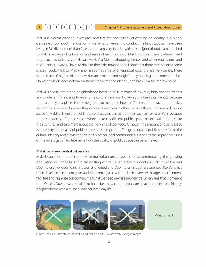
What is next?
3
Chapter 1: Problem statement and Project description 1 2 3 4 5 6 7
Figure 5: Waikiki, Downtown, Kaka’ako, and what is next? (Source: Web - Google images)
Makiki is a great place to investigate and test the possibilities of creating an identity in a highly
dense neighborhood. The location of Makiki is convenient to conduct the fi eld study as I have been
living in Makiki for more than 2 years and I am very familiar with this neighborhood. I am attached
to Makiki because of its location and sense of neighborhood. Makiki is close to everywhere I need
to go such as University of Hawaii, work, Ala Moana Shopping Center, and other retail stores and
restaurants. However, I have to drive to those destinations and I hope that there may become some
places I could walk to. Makiki also has some sense of a neighborhood. It is relatively dense. There
is a mixture of high, mid, and low-rise apartments and single family housing and some churches.
However, Makiki does not have a strong character and identity, and has room for improvement.
Makiki is a very interesting neighborhood because of its mixture of low, mid, high-rise apartments
and single family housing types and its cultural diversity. However, it is losing its identity because
there are only few places for the neighbors to meet and interact. The core of the factor that makes
an identity is people. However, they cannot relate to each other because there is not enough public
space in Makiki. There are highly dense places that have identities such as Tokyo or Paris because
there is a variety of public space. When there is suffi cient public space, people will gather, share
their cultures, and care more about their own neighborhood. Although the amount of public space
is necessary, the quality of public space is also important. The good quality public space forms the
cultural identity and provides a sense of place for local communities. It is one of the improving issues
of this investigation to determine how the quality of public space can be achieved.
Makiki as a new central urban area
Makiki could be one of the new central urban areas capable of accommodating the growing
population in Honolulu. There are existing central urban areas in Honolulu such as Waikiki and
Downtown. However, Waikiki is tourist oriented and Downtown is business oriented. Kaka’ako has
been developed in recent years and is becoming a new central urban area with large entertainment
facilities and high-rise condominiums. What we need next is a new central urban area that is diff erent
from Waikiki, Downtown, or Kaka’ako. It can be a new central urban area that has a sense of a friendly
neighborhood with a human scale for everyday life.
4
Chapter 1: Problem statement and Project description 1 2 3 4 5 6 7
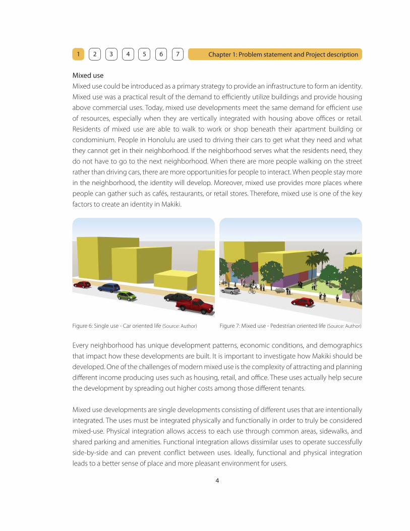
Figure 6: Single use - Car oriented life (Source: Author) Figure 7: Mixed use - Pedestrian oriented life (Source: Author)
Every neighborhood has unique development patterns, economic conditions, and demographics
that impact how these developments are built. It is important to investigate how Makiki should be
developed. One of the challenges of modern mixed use is the complexity of attracting and planning
diff erent income producing uses such as housing, retail, and offi ce. These uses actually help secure
the development by spreading out higher costs among those diff erent tenants.
Mixed use developments are single developments consisting of diff erent uses that are intentionally
integrated. The uses must be integrated physically and functionally in order to truly be considered
mixed-use. Physical integration allows access to each use through common areas, sidewalks, and
shared parking and amenities. Functional integration allows dissimilar uses to operate successfully
side-by-side and can prevent confl ict between uses. Ideally, functional and physical integration
leads to a better sense of place and more pleasant environment for users.
Mixed use
Mixed use could be introduced as a primary strategy to provide an infrastructure to form an identity.
Mixed use was a practical result of the demand to effi ciently utilize buildings and provide housing
above commercial uses. Today, mixed use developments meet the same demand for effi cient use
of resources, especially when they are vertically integrated with housing above offi ces or retail.
Residents of mixed use are able to walk to work or shop beneath their apartment building or
condominium. People in Honolulu are used to driving their cars to get what they need and what
they cannot get in their neighborhood. If the neighborhood serves what the residents need, they
do not have to go to the next neighborhood. When there are more people walking on the street
rather than driving cars, there are more opportunities for people to interact. When people stay more
in the neighborhood, the identity will develop. Moreover, mixed use provides more places where
people can gather such as cafés, restaurants, or retail stores. Therefore, mixed use is one of the key
factors to create an identity in Makiki.

5
Chapter 1: Problem statement and Project description 1 2 3 4 5 6 7
Current land use patterns
As defi ned by Land Use Ordinance, Makiki is zoned as follows:
A-1 (Low-density Apartment District) - 1%
A-2 (Medium-density Apartment District) - 70%
A-3 (High-density Apartment District) - 1%
R-5 (Residential District) - 2%
BMX-3 (Community Business Mixed Use District) - 20%
B-1 (Neighborhood Business District) – 0.1%
P-2 (General Preservation District) - 6%
Approximately 70% of Makiki is zoned as A-2. Makiki is basically divided into two areas by the H-
1 Freeway. Makai side of the H-1 Freeway is mostly zoned as BMX-3 acting as a transitional zone
between the commercial area beyond and the residential area in Makiki. There are only two parcels
zoned as B-1 in the entire Makiki. These two parcels are used as Makiki Shopping Village and it is
apparently not enough to serve the entire Mauka side of the H-1 Freeway.
Figure 8: Zoning map of Makiki (Source: Author)
H-1 Freeway
S. King Street
Pun
aho
u S
tree
t
War
d A
ven
ue

6
Chapter 1: Problem statement and Project description 1 2 3 4 5 6 7
Current condition in Makiki
Lack of identity (homogenization)
Lack of public space (quantity + quality)
Lack of anchor facilities and services such as a grocery store, recreation facilities or cafés
A number of low-rise apartments were built in 1960’s and 1970’s
Low-rise apartments with single use are not as effi cient as mixed use
Land owners are looking for the greatest return on their property because of the high property
tax and high quality value
Major means of transportation is the automobile (dependency on the automobile)
Current residents prefer low to mid-rise apartments because they are afraid that high-rise
buildings may destroy the streetscape and the friendly residential atmosphere (According to the
residents at Makiki neighborhood board meeting)
New projects are mainly high-rise apartments because new developers want to make a profi t by
providing more units in the structure
Makiki is under pressure to increase density because of the growing population
Proposed condition in Makiki
Mixed use could act as a primary strategy that provides an infrastructure to form an identity
Old buildings could be demolished for new mixed use development
Mixed use has a potential to meet the high quality value, as buildings could be effi ciently utilized
to provide multiple uses and activities
Future transit system could change the way of living (car oriented to pedestrian oriented)
High-rise buildings could also achieve great streetscape and pedestrian friendly environment
High density zoning encourages large scale projects to take advantage of the higher densities
The current condition will be analyzed in depth in the following chapters in order to investigate the
methodologies to create an identity followed by the detailed proposed condition in a neighborhood
in general as well as the applied design scenario in Makiki.
•
•
•
•
•
•
•
•
•
•
•
•
•
•
•
•
7
Chapter 1: Problem statement and Project description 1 2 3 4 5 6 7
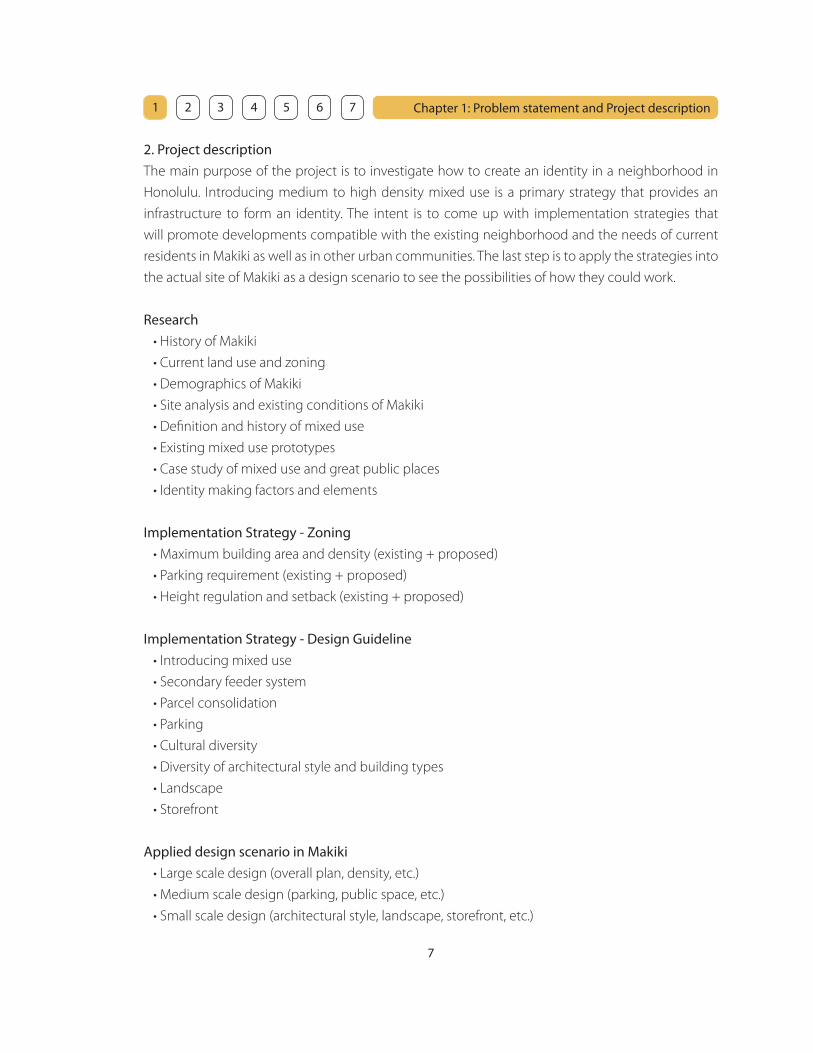
2. Project description
The main purpose of the project is to investigate how to create an identity in a neighborhood in
Honolulu. Introducing medium to high density mixed use is a primary strategy that provides an
infrastructure to form an identity. The intent is to come up with implementation strategies that
will promote developments compatible with the existing neighborhood and the needs of current
residents in Makiki as well as in other urban communities. The last step is to apply the strategies into
the actual site of Makiki as a design scenario to see the possibilities of how they could work.
Research
• History of Makiki
• Current land use and zoning
• Demographics of Makiki
• Site analysis and existing conditions of Makiki
• Defi nition and history of mixed use
• Existing mixed use prototypes
• Case study of mixed use and great public places
• Identity making factors and elements
Implementation Strategy - Zoning
• Maximum building area and density (existing + proposed)
• Parking requirement (existing + proposed)
• Height regulation and setback (existing + proposed)
Implementation Strategy - Design Guideline
• Introducing mixed use
• Secondary feeder system
• Parcel consolidation
• Parking
• Cultural diversity
• Diversity of architectural style and building types
• Landscape
• Storefront
Applied design scenario in Makiki
• Large scale design (overall plan, density, etc.)
• Medium scale design (parking, public space, etc.)
• Small scale design (architectural style, landscape, storefront, etc.)

8
Chapter 1: Problem statement and Project description 1 2 3 4 5 6 7
3. Project site and history
Site
Makiki is located in Honolulu Hawaii, not far from the center and heart of the City. It is located at
the base of Tantalus with Punchbowl on Ewa side. Makiki extends from South King Street to Nehoa
Street in the Mauka (mountain) to Makai (ocean) direction and from Punahou Street to Ward Avenue
in the Diamond Head to Ewa direction.
Figure 9: Site map of Makiki (Source: Google Earth, reproduced by Author)
Makiki
Ala Moana
Waikiki
UHPunchbowl
Dia
mo
nd
He
ad
Ew
a
Mauka
Makai

9
Chapter 1: Problem statement and Project description 1 2 3 4 5 6 7
The site is located in the heart of Makiki. Makiki is divided into two areas by the H-1 Freeway and
these two areas are not related to each other. Makai side of the H-1 Freeway is mostly zoned as BMX-
3 and it already has a character of a commercial district. Buildings are mostly used for offi ce and
retail and it does not have a sense of residential neighborhood except for the area with a number of
mid-rise apartments between the H-1 Freeway and Kinau Street.
In order to achieve the sense of a friendly neighborhood with a human scale, it is necessary to
have a residential atmosphere. Mauka side of the H-1 Freeway is mostly zoned as A-2 and has more
potential to introduce mixed use development with a sense of residential environment, as this area
already has a strong residential character. Therefore, the main focus of the study area is from the H-
1 Freeway to Nehoa Street in the Mauka to Makai direction and from Punahou Street to Pensacola
Street in the Diamond Head to Ewa direction with Wilder Avenue as a main spine of the study area.
Figure 10: Enlarged site map of Makiki (Source: Author)
A-1
A-2
A-3
R-5
BMX-3
B-1
P-2
Wilder Avenue
H-1 Freeway Puna
hou
Stre
et
Pens
acol
a St
reet
S. King Street
Nohea StreetKe
eaou
mok
u St
reet
War
d A
venu
e
10
Chapter 1: Problem statement and Project description 1 2 3 4 5 6 7
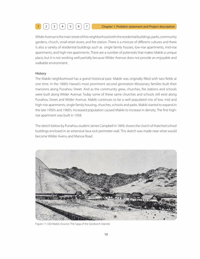
Wilder Avenue is the main street of this neighborhood with the residential buildings, parks, community
gardens, church, small retail stores, and fi re station. There is a mixture of diff erent cultures and there
is also a variety of residential buildings such as single family houses, low-rise apartments, mid-rise
apartments, and high-rise apartments. There are a number of potentials that makes Makiki a unique
place, but it is not working well partially because Wilder Avenue does not provide an enjoyable and
walkable environment.
History
The Makiki neighborhood has a grand historical past. Makiki was originally fi lled with taro fi elds at
one time. In the 1800’s Hawaii’s most prominent second generation Missionary families built their
mansions along Punahou Street. And as the community grew, churches, fi re stations and schools
were built along Wilder Avenue. Today some of these same churches and schools still exist along
Punahou Street and Wilder Avenue. Makiki continues to be a well populated mix of low, mid and
high-rise apartments, single family housing, churches, schools and parks. Makiki started to expand in
the late 1950’s and 1960’s. Increased population caused Makiki to increase in density. The fi rst high-
rise apartment was built in 1958.
The sketch below by Punahou student James Campbell in 1849, shows the clutch of thatched school
buildings enclosed in an extensive lava rock perimeter wall. This sketch was made near what would
become Wilder Avenu and Manoa Road.
Figure 11: Old Makiki (Source: The Saga of the Sandwich Islands)

11
Chapter 1: Problem statement and Project description 1 2 3 4 5 6 7
Figure 14: Map of existing Makiki
showing historical sites (Source: Author)
1879-1898
Irwin Shepherd Home
The Shepherd house was built just before the turn of the century
for Frank Dodge, then Superintendent of the Bishop Estate, and
was purchased by Dr. Irwin Shepherd in 1916. It was constructed
with large, solid timbers. The Shepherds, who had paid the record
price of 35 cents per square foot for the property, had the house
re-wired and added the driveway, porte-cochere and garage. It
was a simple two-story house with the side and back porches
partially enclosed. 1
1898
Saint Clement’s Church
The Parish of Saint Clement celebrated its fi rst service on Easter
Day, 1898 and was consecrated as a church of the Protestant
Episcopal Church of the United States in 1910. The present church
building was under construction when Pearl Harbor was attacked
on December 7, 1941. Construction was halted until the U.S. Army
granted permission to fi nish the structure to be used as a hospital.
The building was completed and consecrated in 1942. 2
Figure 12: Irwin Shepherd Home
(Source: The Old Honolulu)
Figure 13: Saint Clement’s Church
(Source: Author)
Saint Clement’s Church
Irwin Shepherd Home
Existing 2007
Demolished
_______________________________
1. Frances Jackson: The Old Honolulu, Historic Buildings Task Force, Honolulu, 1969
2. Saint Clement’s Website
12
Chapter 1: Problem statement and Project description 1 2 3 4 5 6 7
Figure 17: Map of existing Makiki
showing historical sites (Source: Author)
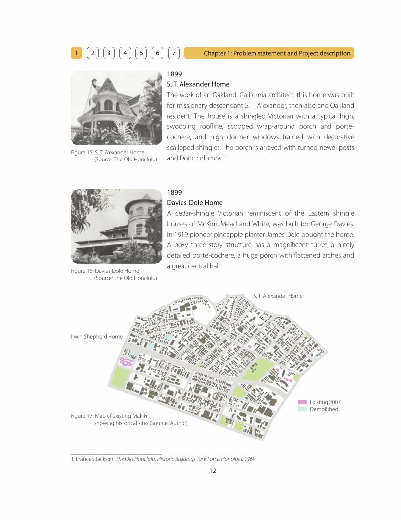
S. T. Alexander Home
Irwin Shepherd Home
Existing 2007
Demolished
1899
S. T. Alexander Home
The work of an Oakland, California architect, this home was built
for missionary descendant S. T. Alexander, then also and Oakland
resident. The house is a shingled Victorian with a typical high,
swooping roofl ine, scooped wrap-around porch and porte-
cochere, and high dormer windows framed with decorative
scalloped shingles. The porch is arrayed with turned newel posts
and Doric columns. 1
Figure 15: S. T. Alexander Home
(Source: The Old Honolulu)
1899
Davies-Dole Home
A cedar-shingle Victorian reminiscent of the Eastern shingle
houses of McKim, Mead and White, was built for George Davies.
In 1919 pioneer pineapple planter James Dole bought the home.
A boxy three-story structure has a magnifi cent turret, a nicely
detailed porte-cochere, a huge porch with fl attened arches and
a great central hall 1
Figure 16: Davies-Dole Home
(Source: The Old Honolulu)
_______________________________
1. Frances Jackson: The Old Honolulu, Historic Buildings Task Force, Honolulu, 1969

13
Chapter 1: Problem statement and Project description 1 2 3 4 5 6 7
Figure 20: Map of existing Makiki
showing historical sites (Source: Author)
H. F. Wichman Home
Existing 2007
Demolished
1899
F. J. Lowrey Home
The old F. J. Lowrey home was an angular Victorian with a cut
blue stone foundation, half round enclosed lanai and wide
overhanging eaves supported by brackets. An interesting feature
was the pair of squared towers with metal balconies which gave
the whole house a Spanish look. The building was headquarters of
the Hawaii Tuberculosis and Respiratory Disease Association until
it was torn down in 1969 to make way for an apartment house. 1
Figure 18: F. J. Lowrey Home
(Source: The Old Honolulu)
Figure 19: H. F. Wichman Home
(Source: The Old Honolulu)
1902
H. F. Wichman Home
An exuberant gingerbread Victorian with familiar octagonal tower,
this home was built for Honolulu jeweler H. F. Wichman in 1902. It
is a versatile exhibit of wood carpentry work, including wood slat
grills over basement vents of various sizes, decorated half round
gable vents, intricate porch railings and a wooden awning with
scalloped edges. 1
F. J. Lowrey Home
_______________________________
1. Frances Jackson: The Old Honolulu, Historic Buildings Task Force, Honolulu, 1969
14
Chapter 1: Problem statement and Project description 1 2 3 4 5 6 7
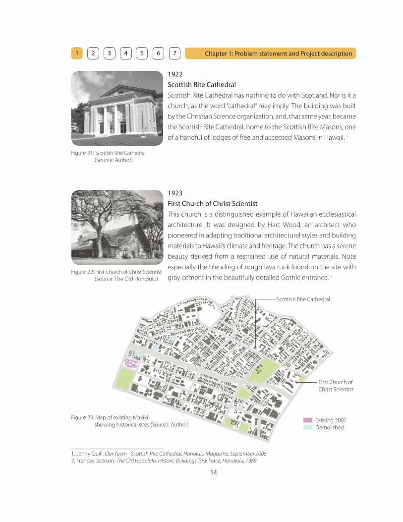
Figure 23: Map of existing Makiki
showing historical sites (Source: Author)Existing 2007
Demolished
Figure 22: First Church of Christ Scientist
(Source: The Old Honolulu)
1923
First Church of Christ Scientist
This church is a distinguished example of Hawaiian ecclesiastical
architecture. It was designed by Hart Wood, an architect who
pioneered in adapting traditional architectural styles and building
materials to Hawaii’s climate and heritage. The church has a serene
beauty derived from a restrained use of natural materials. Note
especially the blending of rough lava rock found on the site with
gray cement in the beautifully detailed Gothic entrance. 2
First Church of
Christ Scientist
1922
Scottish Rite Cathedral
Scottish Rite Cathedral has nothing to do with Scotland. Nor is it a
church, as the word “cathedral” may imply. The building was built
by the Christian Science organization, and, that same year, became
the Scottish Rite Cathedral, home to the Scottish Rite Masons, one
of a handful of lodges of free and accepted Masons in Hawaii. 1
Figure 21: Scottish Rite Cathedral
(Source: Author)
Scottish Rite Cathedral
_______________________________
1. Jenny Quill: Our Town - Scottish Rite Cathedral, Honolulu Magazine, September 2006
2. Frances Jackson: The Old Honolulu, Historic Buildings Task Force, Honolulu, 1969

15
Chapter 1: Problem statement and Project description 1 2 3 4 5 6 7
Figure 26: Map of existing Makiki
showing historical sites (Source: Author)Existing 2007
Demolished
Figure 24: Honolulu Academy of Arts
(Source: The Old Honolulu)
1927
Honolulu Academy of Arts
Honolulu Academy of Arts is a great example of what has come
to be know as “Hawaiian architecture” designed by an architect,
Bertram Goodhue. This style is characterized by a high peaked
roof, a modifi cation of the grass house profi le, that extends
over wide verandas connecting single-depth rooms. Beautifully
landscaped open courts are surrounded by the galleries. The
layout is reminiscent of the pavilion plan of Chinese homes. 1
Makiki Fire Station
1929
Makiki Fire Station
Mission/Spanish Revival style fi re station was built by an architect
Solomon F. Kenn, Robert McMillian Co. This building was built at
a cost of $33,833.50. 2
Figure 25: Makiki Fire Station
(Source: Author)
Honolulu
Academy of Arts
_______________________________
1. Frances Jackson: The Old Honolulu, Historic Buildings Task Force, Honolulu, 1969
2. Website - National Register of Historic Places
16
Chapter 1: Problem statement and Project description 1 2 3 4 5 6 7
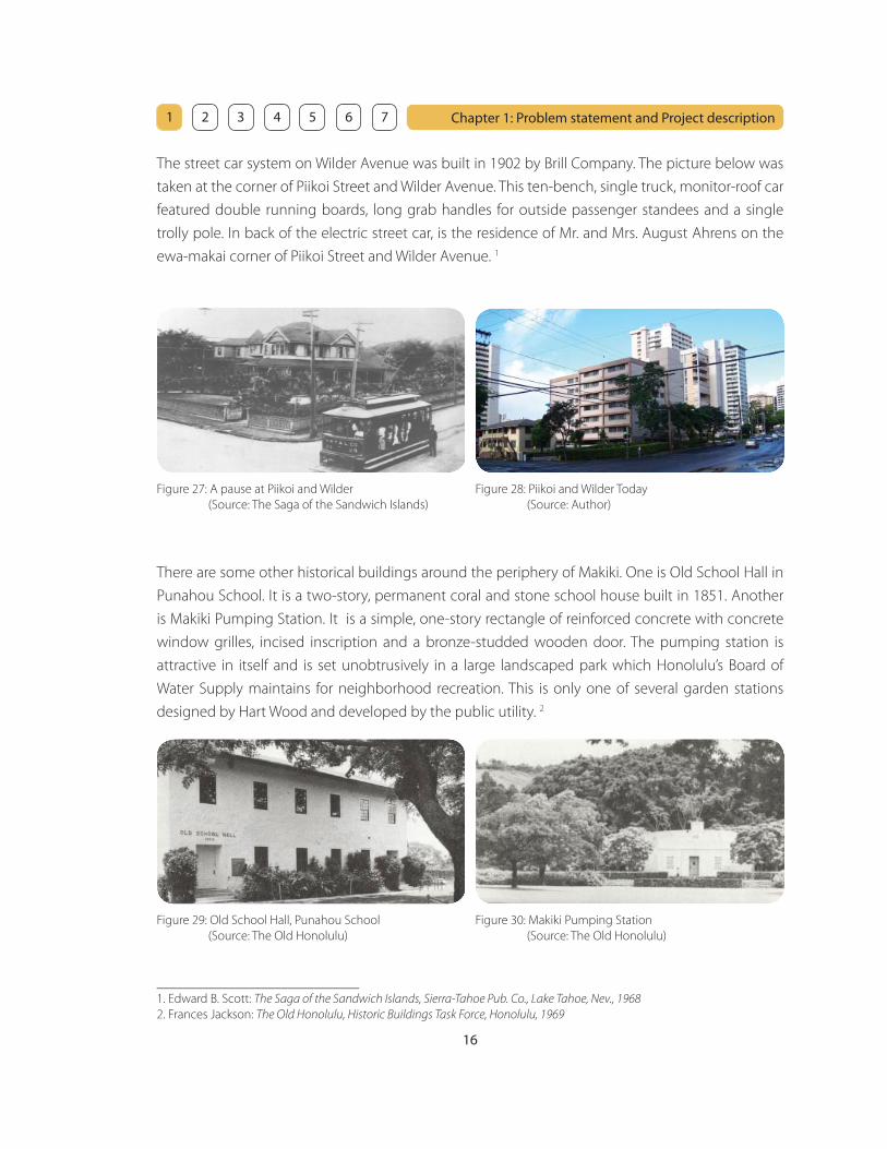
The street car system on Wilder Avenue was built in 1902 by Brill Company. The picture below was
taken at the corner of Piikoi Street and Wilder Avenue. This ten-bench, single truck, monitor-roof car
featured double running boards, long grab handles for outside passenger standees and a single
trolly pole. In back of the electric street car, is the residence of Mr. and Mrs. August Ahrens on the
ewa-makai corner of Piikoi Street and Wilder Avenue. 1
Figure 27: A pause at Piikoi and Wilder
(Source: The Saga of the Sandwich Islands)
Figure 28: Piikoi and Wilder Today
(Source: Author)
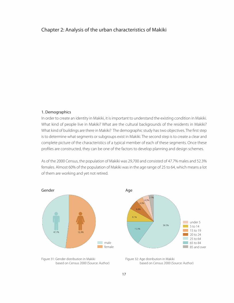
There are some other historical buildings around the periphery of Makiki. One is Old School Hall in
Punahou School. It is a two-story, permanent coral and stone school house built in 1851. Another
is Makiki Pumping Station. It is a simple, one-story rectangle of reinforced concrete with concrete
window grilles, incised inscription and a bronze-studded wooden door. The pumping station is
attractive in itself and is set unobtrusively in a large landscaped park which Honolulu’s Board of
Water Supply maintains for neighborhood recreation. This is only one of several garden stations
designed by Hart Wood and developed by the public utility. 2
Figure 30: Makiki Pumping Station
(Source: The Old Honolulu)
Figure 29: Old School Hall, Punahou School
(Source: The Old Honolulu)
_______________________________
1. Edward B. Scott: The Saga of the Sandwich Islands, Sierra-Tahoe Pub. Co., Lake Tahoe, Nev., 1968
2. Frances Jackson: The Old Honolulu, Historic Buildings Task Force, Honolulu, 1969
17
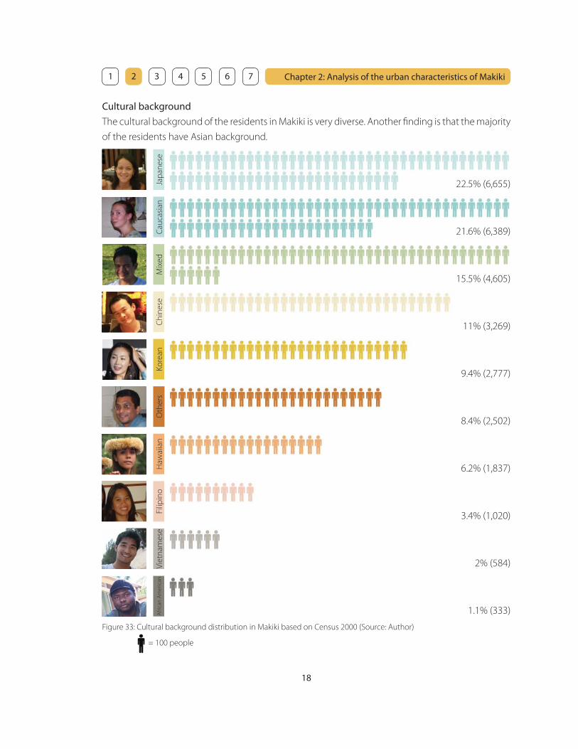
1. Demographics
In order to create an identity in Makiki, it is important to understand the existing condition in Makiki.
What kind of people live in Makiki? What are the cultural backgrounds of the residents in Makiki?
What kind of buildings are there in Makiki? The demographic study has two objectives. The fi rst step
is to determine what segments or subgroups exist in Makiki. The second step is to create a clear and
complete picture of the characteristics of a typical member of each of these segments. Once these
profi les are constructed, they can be one of the factors to develop planning and design schemes.
As of the 2000 Census, the population of Makiki was 29,700 and consisted of 47.7% males and 52.3%
females. Almost 60% of the population of Makiki was in the age range of 25 to 64, which means a lot
of them are working and yet not retired.
Chapter 2: Analysis of the urban characteristics of Makiki
under 5
5 to 14
15 to 19
20 to 24
25 to 64
65 to 84
85 and over
AgeGender
male
female
Figure 31: Gender distribution in Makiki
based on Census 2000 (Source: Author)
Figure 32: Age distribution in Makiki
based on Census 2000 (Source: Author)
Chapter 2: Analysis of the urban characteristics of Makiki
18
1 2 3 4 5 6 7
Cultural background
The cultural background of the residents in Makiki is very diverse. Another fi nding is that the majority
of the residents have Asian background.
Jap
an
ese
Ca
uca
sia
nM
ixe
dC
hin
ese
Ko
rea
nO
the
rsH
awa
iian
Filip
ino
Vie
tna
me
seA
fric
an
Am
eri
can
Figure 33: Cultural background distribution in Makiki based on Census 2000 (Source: Author)
= 100 people
22.5% (6,655)
21.6% (6,389)
15.5% (4,605)
11% (3,269)
9.4% (2,777)
8.4% (2,502)
6.2% (1,837)
3.4% (1,020)
2% (584)
1.1% (333)

Chapter 2: Analysis of the urban characteristics of Makiki
19
1 2 3 4 5 6 7
Place of Birth
Almost half of the population of Makiki was born in Hawaii. It is interesting that there are more
people who were born in a foreign country than people who were born in other state in the U.S. This
data explains the reason of cultural diversity in Makiki.
Hawaii
Other State
Foreign born
22.8% (6,777)
28.1% (8,355)
49.1% (14,578)
Figure 34: Place of birth distribution in Makiki based on Census 2000 (Source: Author)
= 100 people
Household type
More than half of the population of Makiki is non-family household, which could mean a lot of them
are relatively young and do not have a family, and they are transient people. Another statistics shows
that 60% of the population of Makiki rent their place instead of owning it. This statistics also tells that
there are a number of transient people in Makiki.
54% (8,099)
22% (3,299)
12% (1,800)
6.3% (945)
5.7% (855)
non-family household
family household w/o children
family household w/ children
female family household (no husband present) w/o children
female family household (no husband present) w/ children
Figure 35: Household type distribution in Makiki based on Census 2000 (Source: Author)

Chapter 2: Analysis of the urban characteristics of Makiki
20
1 2 3 4 5 6 7
1 unit - detached
1 unit - attached
2 units
3 or 4 units
15 to 9 units
10 to 19 units
20 or more units
Figure 36: Units in structure distribution in Makiki based on Census 2000 (Source: Author)
= 100 units
8.5% (1,383)
2% (321)
1.8% (300)
3.4% (552)
7.8% (1,262)
13.6% (2,214)
62.9% (10,235)
Units in housing structures
More than 60% of the units in Makiki are accommodated in structures that have 20 or more units.
This data shows that the density in Makiki is relatively high and most of them are apartments.
However, this does not show if apartments are low-rise or high-rise because a low-rise apartment
can accommodate more than 20 units.
Chapter 2: Analysis of the urban characteristics of Makiki
21
1 2 3 4 5 6 7
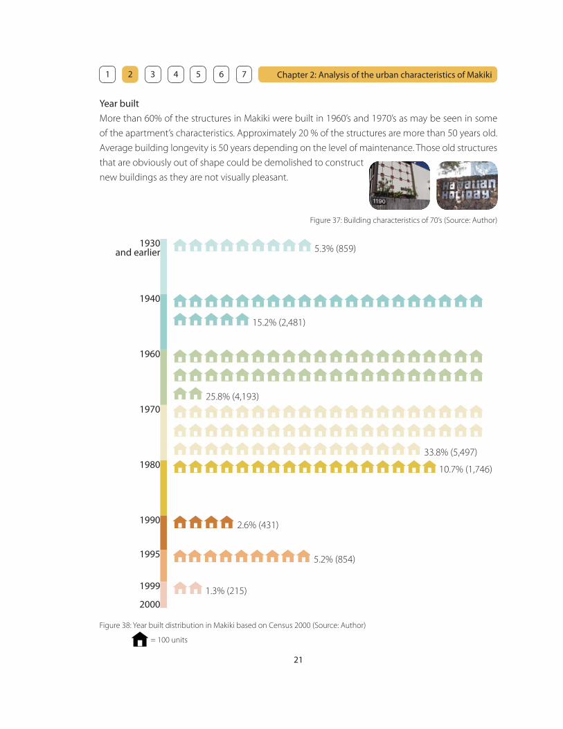
Year built
More than 60% of the structures in Makiki were built in 1960’s and 1970’s as may be seen in some
of the apartment’s characteristics. Approximately 20 % of the structures are more than 50 years old.
Average building longevity is 50 years depending on the level of maintenance. Those old structures
that are obviously out of shape could be demolished to construct
new buildings as they are not visually pleasant.
1940
1960
1970
1980
1990
1995
2000
1930and earlier
1999
= 100 units
Figure 38: Year built distribution in Makiki based on Census 2000 (Source: Author)
5.3% (859)
15.2% (2,481)
25.8% (4,193)
33.8% (5,497)
10.7% (1,746)
2.6% (431)
1.3% (215)
5.2% (854)
Figure 37: Building characteristics of 70’s (Source: Author)
Chapter 2: Analysis of the urban characteristics of Makiki
22
1 2 3 4 5 6 7
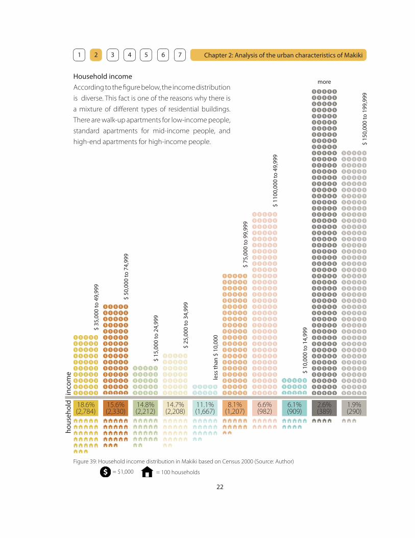
Household income
According to the fi gure below, the income distribution
is diverse. This fact is one of the reasons why there is
a mixture of diff erent types of residential buildings.
There are walk-up apartments for low-income people,
standard apartments for mid-income people, and
high-end apartments for high-income people.
inco
me
hous
ehol
d
= 100 households
Figure 39: Household income distribution in Makiki based on Census 2000 (Source: Author)
= $1,000
$ 35
,000
to 4
9,99
9
18.6% (2,784)
$ 50
,000
to 7
4,99
9
15.6% (2,330)
$ 15
,000
to 2
4,99
9
14.8% (2,212)
$ 25
,000
to 3
4,99
9
14.7% (2,208)
$ 75
,000
to 9
9,99
9
8.1% (1,207)
$ 11
00,0
00 to
49,
999
6.6% (982)
less
than
$ 1
0,00
0
11.1% (1,667)
$ 10
,000
to 1
4,99
9
6.1% (909)
2.6% (389)
$ 15
0,00
0 to
199
,999
1.9% (290)
more

Chapter 2: Analysis of the urban characteristics of Makiki
23
1 2 3 4 5 6 7
drive alone
carpool
public transportation
walk
other means
work at home
Means of transportation to work
More than half of the workers in Makiki drive alone to work. Introducing mixed use in Makiki gives
the neighbors more opportunity to work at home (live/work situation) or walk to work. This helps
Makiki reduce the traffi c and create a pedestrian friendly neighborhood.
Figure 40: Means of transportation to work distribution in Makiki based on Census 2000 (Source: Author)
= 100 workers
57.4% (8,713)
16.3% (2,468)
13.8% (2,101)
5.5% (836)
4.1% (624)
2.8% (431)
Chapter 2: Analysis of the urban characteristics of Makiki
24
1 2 3 4 5 6 7
2. Site analysis
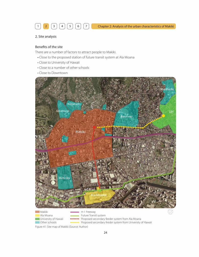
Benefi ts of the site
There are a number of factors to attract people to Makiki.
• Close to the proposed station of future transit system at Ala Moana
• Close to University of Hawaii
• Close to a number of other schools
• Close to Downtown
Figure 41: Site map of Makiki (Source: Author)
Makiki
Ala Moana
University of Hawaii
Other schools
H-1 Freeway
Future Transit system
Proposed secondary feeder system from Ala Moana
Proposed secondary feeder system from University of Hawaii
Makiki
Punahou
UH
Ala Moana
McKinley
Roosevelt
Stevenson
Mid-Pacifi c
Chapter 2: Analysis of the urban characteristics of Makiki
25
1 2 3 4 5 6 7
The station of the future transit system is proposed to be located at Ala Moana shopping center.
It will be a great opportunity to draw people into Makiki by introducing secondary transit feeder
system such as trolleys on Keeoumoku Street. This could be possible when Makiki becomes a new
destination as a new central urban area.
Makiki is surrounded by a number of schools and University of Hawaii is less than a mile away. As
there is no place for students to go and hang out after school now, Makiki could be a new place for
students to gather, eat, or study. Also, Makiki could be a place to stop by for the parents who drop
off and pick up their children at school around Makiki.
Therefore, Makiki will be a magnet not only for the residents in Makiki, but also for people outside
of Makiki such as:
• People who use transit system
• People at Ala Moana shopping center
• Students from University of Hawaii
• Students from other schools around Makiki
• Parents of the students who drop off and pick up their children
Given that Makiki should introduce mixed use, people from outside would give a strong impact on
Makiki because a good number of people is necessary to make it vibrant and support the business
and activities in the mixed use neighborhood.

Chapter 2: Analysis of the urban characteristics of Makiki
28
1 2 3 4 5 6 7
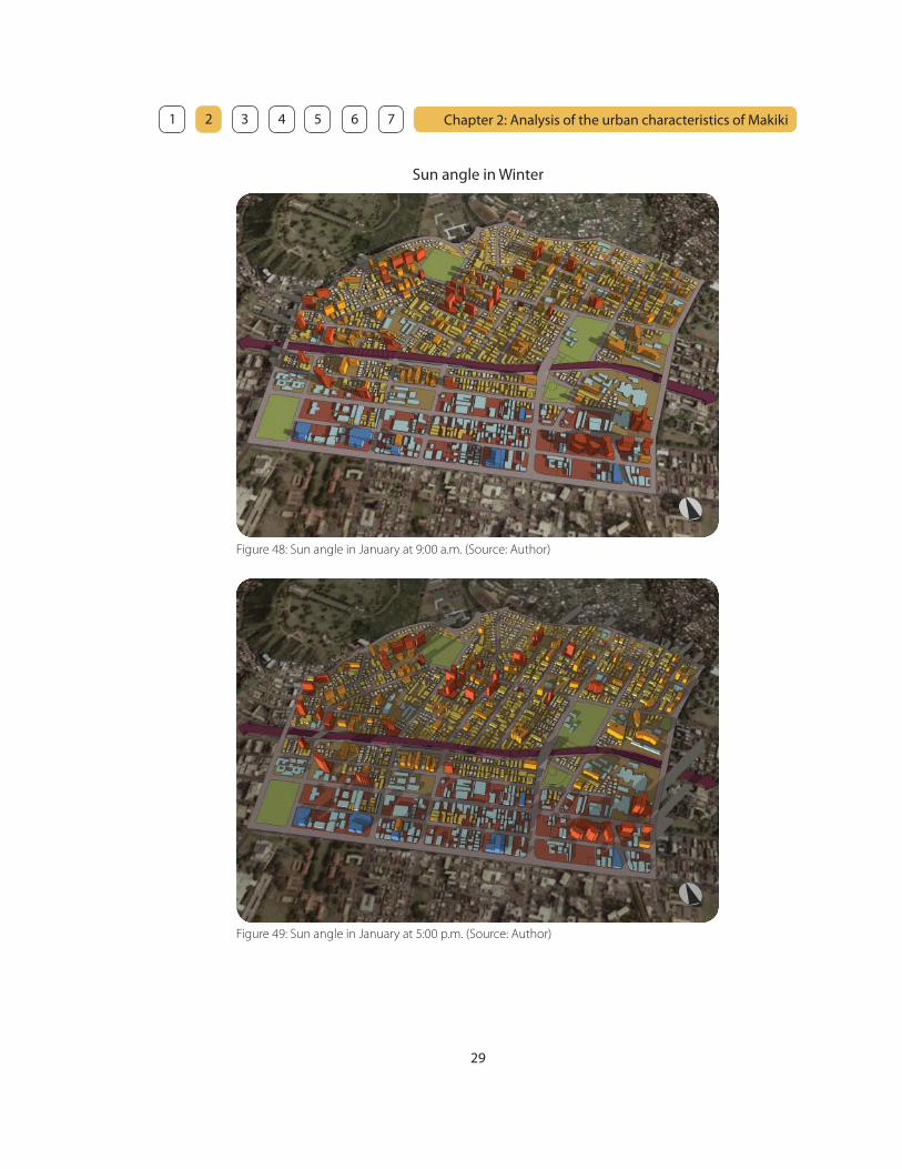
Sun angle
In order to achieve a successful design, it is important to understand the relationship between the
sun and buildings in diff erent seasons for an effi cient solar control. An effi cient solar control means
to eliminate or minimize the eff ect of the sun on buildings when excessive heat and glare is not
necessary during overheated period of the year, and to get maximum solar radiation when heat is
necessary during the under-heated period.
Figure 46: Sun angle in September at 9:00 a.m. (Source: Author)
Figure 47: Sun angle in September at 5:00 p.m. (Source: Author)
Sun angle in Summer
Chapter 2: Analysis of the urban characteristics of Makiki
29
1 2 3 4 5 6 7
Sun angle in Winter
Figure 49: Sun angle in January at 5:00 p.m. (Source: Author)
Figure 48: Sun angle in January at 9:00 a.m. (Source: Author)
Chapter 2: Analysis of the urban characteristics of Makiki
30
1 2 3 4 5 6 7
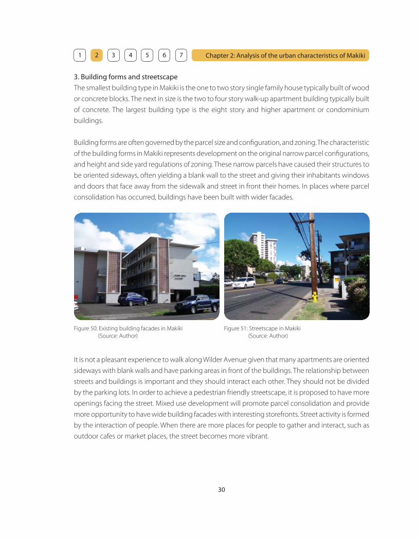
3. Building forms and streetscape
The smallest building type in Makiki is the one to two story single family house typically built of wood
or concrete blocks. The next in size is the two to four story walk-up apartment building typically built
of concrete. The largest building type is the eight story and higher apartment or condominium
buildings.
Building forms are often governed by the parcel size and confi guration, and zoning. The characteristic
of the building forms in Makiki represents development on the original narrow parcel confi gurations,
and height and side yard regulations of zoning. These narrow parcels have caused their structures to
be oriented sideways, often yielding a blank wall to the street and giving their inhabitants windows
and doors that face away from the sidewalk and street in front their homes. In places where parcel
consolidation has occurred, buildings have been built with wider facades.
Figure 50: Existing building facades in Makiki
(Source: Author)
Figure 51: Streetscape in Makiki
(Source: Author)
It is not a pleasant experience to walk along Wilder Avenue given that many apartments are oriented
sideways with blank walls and have parking areas in front of the buildings. The relationship between
streets and buildings is important and they should interact each other. They should not be divided
by the parking lots. In order to achieve a pedestrian friendly streetscape, it is proposed to have more
openings facing the street. Mixed use development will promote parcel consolidation and provide
more opportunity to have wide building facades with interesting storefronts. Street activity is formed
by the interaction of people. When there are more places for people to gather and interact, such as
outdoor cafes or market places, the street becomes more vibrant.

Chapter 2: Analysis of the urban characteristics of Makiki
31
1 2 3 4 5 6 7
There are other important factors to achieve a pedestrian friendly streetscape such as the way
sidewalks and landscape are designed. Wilder Avenue has some landscaped areas including street
trees, shrubs and narrow strips of grass. However, the landscape is not playing an important role to
create a pleasant walking experience. Most shrubs are merely used to separate the sidewalk and the
properties. Grass strips are not well maintained and half dead. There are only few fl owering trees and
shrubs. In spite of the existing landscape, the impression of Wilder Avenue is “gloomy”. Moreover, the
existing sidewalks are too narrow to enjoy walking and they need to be revised because many areas
have cracks due to age or tree roots uplifting the sidewalks.
Another problem that destroys the streetscape is the accumulated rubbish on the sidewalks. It
becomes a vicious circle. As the sidewalks are not pleasant, residents do not respect the streetspace
and discard bulky trash such as unnecessary furniture. If the sidewalks become attractive, the
residents would care about it and keep it clean. The clean and attractive streetscape also provides a
safe environment.
Figure 52: The narrow sidewalk in Makiki (Source: Author) Figure 53: The bulky trash on the sidewalk (Source: Author)

Chapter 2: Analysis of the urban characteristics of Makiki
32
1 2 3 4 5 6 7
4. Activities on Wilder Avenue
Wilder Avenue has heavy traffi c during the hours of school drop-off and pick-up, and also after work
hours to avoid the traffi c jam on H-1 Freeway. However, there are not so many street activities due
to lack of public space and commercial facilities such as parks, grocery stores, recreation facilities or
cafés. Pedestrians are hardly seen because the walking experience is not so pleasant and there are
few walkable destinations except for Makiki Shopping Village and Makiki District Park.
Makiki Shopping Village
Makiki Shopping Village is the only place to eat or shop on Mauka side of the H-1 Freeway in all of
Makiki. The uses of this Shopping Village include:
Figure 54: Makiki Shopping Village (Source: Author)
• Small super market
• Coff ee shop
• Fastfood restaurants
• Barber shop
• Laundry
• Video shop
• Wine store
The fastfood restaurants are well occupied only after school hours when high school students come
and get snacks before they go home. Pizza Hut here is one of the busiest chains in the state to serve
the high density of entire Makiki. Otherwise, other restaurants are relatively empty during dinner
time. The coff ee shop is never well occupied. As the supermarket is small and does not have wide
range of goods, people drive to other supermarkets. The laundry is always full of people, but there is
no place to sit and wait. The wine store has good selections, but it is underground and hard to fi nd.
Makiki defi nitely needs more retail stores that attract people. As a resident of Makiki, it is unfortunate
to have to drive to somewhere else for coff ee with friends instead of walking to a favorite place in
your own neighborhood.

Chapter 2: Analysis of the urban characteristics of Makiki
33
1 2 3 4 5 6 7
Makiki District Park
Makiki District Park is well occupied on weekends for diff erent activities and it is the only public
open space that serves the Mauka side of H-1 Freeway of entire Makiki. The park uses include:
Figure 55: Makiki District Park (Source: Author)
• Large lawn area
• Community garden
• Swimming pool
• Tennis courts
• Basketball courts
• Skate board park
• Arts & Craft building
• Library (currently closed)
The large lawn area is used for many diff erent activities such as soccer, football, and volleyball
especially on weekends. It is also used for mothers to play with their little children. Tennis courts and
basketball courts are well occupied at night around 5:00 p.m. to 8:00 p.m. with people who want to
have exercise after school or work. This park functions relatively well, but there are still some aspects
that are not functioning very well. The community garden is divided into individual parcels and each
parcel has ugly fences all around. The users are afraid of getting their plants messed up or stolen.
The interior of the Arts & Craft building does not provide a pleasant environment because it is an old
building. The library has been closed since they are planning to renovate, but the renovation has not
started yet. There are other buildings that are also not used for a while. Neglected empty buildings
give an “unsafe” impression. Moreover, the park is isolated. It would be more convenient if this park
was connected to Makiki Shopping Village to get something to eat after exercise or buy groceries on
the way home. If they are connected, Makiki Shopping Village would be more vibrant. The unused
buildings could be utilized for other uses such as a gym, coff ee shop or snack stands.
34
Chapter 3: What is Mixed use?
1. Defi nition of mixed use development
As stated in Chapter 1, mixed use could be introduced as a primary strategy that provides an
infrastructure to form an identity in a neighborhood. Mixed use development refers to the practice
of allowing more than one type of use in a building or set of buildings. In planning terms, this
can mean some combination of residential, commercial, industrial, offi ce, institutional, or other land
uses.
2. History of mixed use
Throughout most of human history, the majority of human settlements developed as mixed-use
environments. Walking was the primary way that people and goods were moved about, sometimes
assisted by animals such as horses or cattle. Most people lived in buildings that were places of work
as well as domestic life, and made things or sold things from their own homes. Most buildings were
not divided into discrete functions on a room by room basis, and most neighborhoods contained
a diversity of uses, even if some districts developed a predominance of certain trades, such as
metalworkers, or textiles or footwear due to the socio-economic benefi ts of propinquity. People
lived at very high densities because the amount of space required for daily living and movement
between diff erent activities was determined by walkability and the scale of the human body. This
was particularly true in cities, and the ground fl oor of buildings was often devoted to some sort of
commercial or productive use, with living space upstairs.
This historical mixed-used pattern of development declined during industrialization in favor of
large-scale early capitalist-style manufacturing in single-function buildings. This period saw massive
migrations of people from rural areas to cities drawn by work in factories and the associated
businesses and bureaucracies that grew up around them.

35
Chapter 3: What is Mixed use? 1 2 3 4 5 6 7
Figure 56: The Plan Voisin, Ville Contemporaine and Ville Radieuse (Source: Web - “Diff erent visions of the future”)
In the United States, another impetus for Euclidian zoning was the birth of the skyscraper. Fear of
buildings blocking out the sun led many to call for zoning regulations, particularly in New York City.
Zoning regulations, fi rst put into place in 1916, not only called for limits on building heights, but
eventually called for separations of uses. This was largely meant to keep people away from living
next to polluted industrial areas. This separation however, was extended to commercial uses as well,
setting the stage for the suburban style of life that is common in America today. This type of zoning
was widely adopted by municipal zoning codes. 1
With the advent of mass transit systems, but especially the private automobile and cheap oil, the
ability to create dispersed, low-density cities where people could live very long distances from their
workplaces, shopping centers and entertainment districts began in earnest. However, it has been
the post-second World War dominance of the automobile and the decline in all other modes of
urban transportation that has seen the extremes of these trends come to pass.
The infl ux of new workers needed to be accommodated and many new urban districts arose at this
time with domestic housing being their primary function. Thus began a separating out of land uses
that previously had occurred in the same spaces. Furthermore, many factories produced substantial
pollution of various kinds. Distance was required to minimize adverse impacts from noise, dirt,
noxious fumes and dangerous substances. Even so, at this time, most industrialized cities were of a
size that allowed people to walk between the diff erent areas of the city.
These factors were important in the push for Euclidian zoning premised on the compartmentalization
of land uses into like functions and their spatial separation. In Europe, advocates of the Garden City
Movement were attempting to think through these issues and propose improved ways to plan cities
based on zoning areas of land so that confl icts between land uses would be minimized. Modern
architects such as Le Corbusier advocated radical rethinking of the way cities were designed based
on similar ideas, proposing plans for Paris such as the Plan Voisin, Ville Contemporaine and Ville
Radieuse that involved demolishing the entire centre of the city and replacing it with towers in a
park-like setting, with industry carefully sited away from other uses.
_______________________________
1. Dean Schwanke: Mixed-use Development Handbook, Urban Land Institute, Washington, D. C., 2003
36
Chapter 3: What is Mixed use? 1 2 3 4 5 6 7
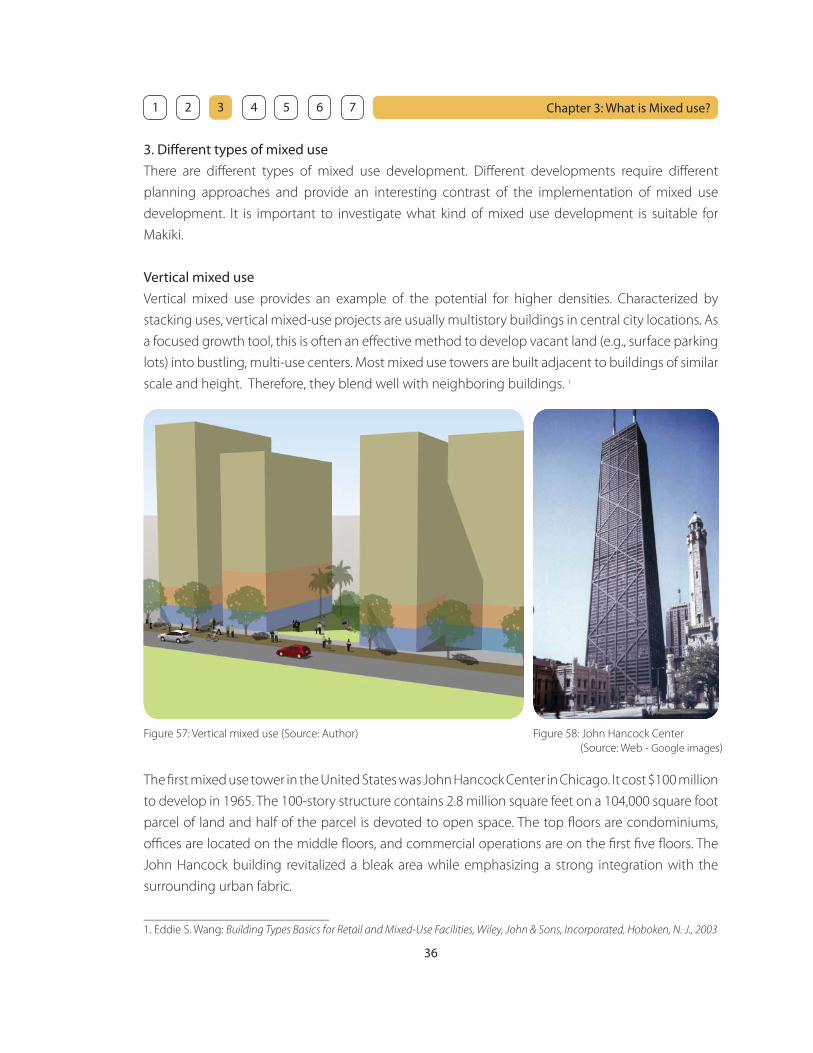
3. Diff erent types of mixed use
There are diff erent types of mixed use development. Diff erent developments require diff erent
planning approaches and provide an interesting contrast of the implementation of mixed use
development. It is important to investigate what kind of mixed use development is suitable for
Makiki.
Vertical mixed use
Vertical mixed use provides an example of the potential for higher densities. Characterized by
stacking uses, vertical mixed-use projects are usually multistory buildings in central city locations. As
a focused growth tool, this is often an eff ective method to develop vacant land (e.g., surface parking
lots) into bustling, multi-use centers. Most mixed use towers are built adjacent to buildings of similar
scale and height. Therefore, they blend well with neighboring buildings. 1
The fi rst mixed use tower in the United States was John Hancock Center in Chicago. It cost $100 million
to develop in 1965. The 100-story structure contains 2.8 million square feet on a 104,000 square foot
parcel of land and half of the parcel is devoted to open space. The top fl oors are condominiums,
offi ces are located on the middle fl oors, and commercial operations are on the fi rst fi ve fl oors. The
John Hancock building revitalized a bleak area while emphasizing a strong integration with the
surrounding urban fabric.
Figure 57: Vertical mixed use (Source: Author) Figure 58: John Hancock Center
(Source: Web - Google images)
_______________________________
1. Eddie S. Wang: Building Types Basics for Retail and Mixed-Use Facilities, Wiley, John & Sons, Incorporated, Hoboken, N. J., 2003
37
Chapter 3: What is Mixed use? 1 2 3 4 5 6 7
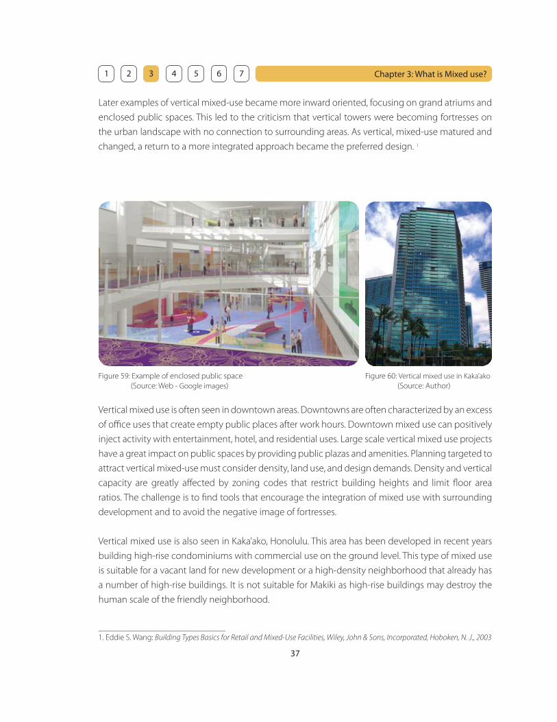
Later examples of vertical mixed-use became more inward oriented, focusing on grand atriums and
enclosed public spaces. This led to the criticism that vertical towers were becoming fortresses on
the urban landscape with no connection to surrounding areas. As vertical, mixed-use matured and
changed, a return to a more integrated approach became the preferred design. 1
Vertical mixed use is often seen in downtown areas. Downtowns are often characterized by an excess
of offi ce uses that create empty public places after work hours. Downtown mixed use can positively
inject activity with entertainment, hotel, and residential uses. Large scale vertical mixed use projects
have a great impact on public spaces by providing public plazas and amenities. Planning targeted to
attract vertical mixed-use must consider density, land use, and design demands. Density and vertical
capacity are greatly aff ected by zoning codes that restrict building heights and limit fl oor area
ratios. The challenge is to fi nd tools that encourage the integration of mixed use with surrounding
development and to avoid the negative image of fortresses.
Vertical mixed use is also seen in Kaka’ako, Honolulu. This area has been developed in recent years
building high-rise condominiums with commercial use on the ground level. This type of mixed use
is suitable for a vacant land for new development or a high-density neighborhood that already has
a number of high-rise buildings. It is not suitable for Makiki as high-rise buildings may destroy the
human scale of the friendly neighborhood.
Figure 59: Example of enclosed public space
(Source: Web - Google images)
Figure 60: Vertical mixed use in Kaka’ako
(Source: Author)
_______________________________
1. Eddie S. Wang: Building Types Basics for Retail and Mixed-Use Facilities, Wiley, John & Sons, Incorporated, Hoboken, N. J., 2003
38
Chapter 3: What is Mixed use? 1 2 3 4 5 6 7
Town center planned mixed use
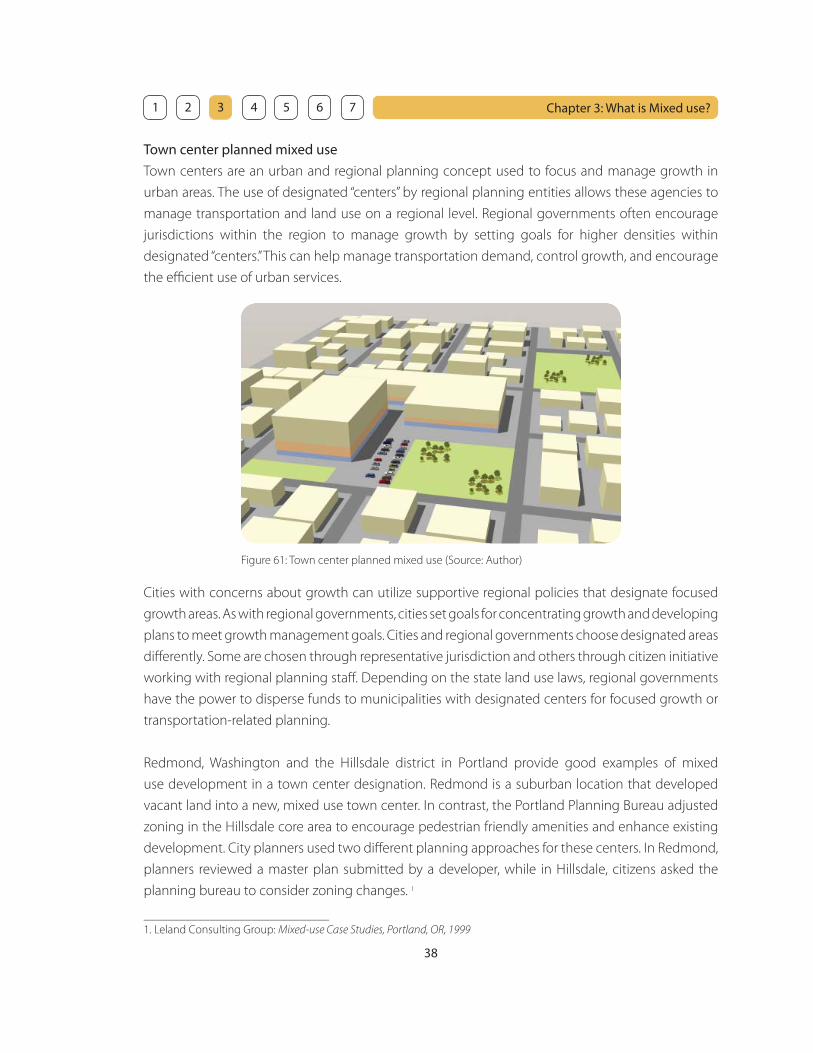
Town centers are an urban and regional planning concept used to focus and manage growth in
urban areas. The use of designated “centers” by regional planning entities allows these agencies to
manage transportation and land use on a regional level. Regional governments often encourage
jurisdictions within the region to manage growth by setting goals for higher densities within
designated “centers.” This can help manage transportation demand, control growth, and encourage
the effi cient use of urban services.
Cities with concerns about growth can utilize supportive regional policies that designate focused
growth areas. As with regional governments, cities set goals for concentrating growth and developing
plans to meet growth management goals. Cities and regional governments choose designated areas
diff erently. Some are chosen through representative jurisdiction and others through citizen initiative
working with regional planning staff . Depending on the state land use laws, regional governments
have the power to disperse funds to municipalities with designated centers for focused growth or
transportation-related planning.
Redmond, Washington and the Hillsdale district in Portland provide good examples of mixed
use development in a town center designation. Redmond is a suburban location that developed
vacant land into a new, mixed use town center. In contrast, the Portland Planning Bureau adjusted
zoning in the Hillsdale core area to encourage pedestrian friendly amenities and enhance existing
development. City planners used two diff erent planning approaches for these centers. In Redmond,
planners reviewed a master plan submitted by a developer, while in Hillsdale, citizens asked the
planning bureau to consider zoning changes. 1
Figure 61: Town center planned mixed use (Source: Author)
_______________________________
1. Leland Consulting Group: Mixed-use Case Studies, Portland, OR, 1999

39
Chapter 3: What is Mixed use? 1 2 3 4 5 6 7
Town center planned mixed use could be suitable for Makiki because Makiki needs to be a new urban
center and that requires zoning changes. The mixed use center will provide a new urban focus for
Makiki by introducing a secondary mass transit feeder system from Ala Moana and providing shop-
lined streets, landscaped plazas or parks. A mix of uses encourages a vibrant core of activity. It also
maintains many acres of open space, integrates community plazas with open space, and integrates
the existing residential areas with development to increase overall livability.
Figure 62: Redmond Town Center
(Source: Web - Google image)
Figure 63: Hillsdale mixed use planning
(Source: Web - Google image)
Adaptive mixed use
The adaptive reuse of older buildings is becoming more attractive as an emerging opportunity for
creative mixed use redevelopment. Adaptive reuse typically involves converting older buildings to
a new mix of uses. Adaptive reuse of existing buildings is attractive for planners concerned with
revitalizing the city and historic districts through private investment. Adaptive mixed-use provides
an opportunity for redevelopment of cities that have seen years of neglect and divestment.
Figure 64: Adaptive mixed use (Source: Author)

40
Chapter 3: What is Mixed use? 1 2 3 4 5 6 7
The unique historic quality of old city areas off ers planners and developers a shared opportunity
to attract residents to inhabit mixed use developments. Cities that want to encourage mixed use
redevelopment can capitalize on market changes to reclaim blighted areas. Older business districts
provide opportunities for adaptive mixed use because they typically contain underutilized or vacant
historic buildings that could support a mix of residential and commercial uses. Adaptive reuse of
buildings has become economically feasible because real estate market changes have made mixed-
use more aff ordable.
Adaptive reuse projects are more planning intensive because of zoning and building code issues.
Adaptive reuse requires upgrading older buildings and, therefore, presents both code and historic
preservation issues. One of the important roles of planners is to require safe approaches to retrofi tting
buildings. Redevelopment challenges are overcome by fi nding new methods to meet seismic and
fi re codes that preserve buildings and ensure public safety. However, these barriers often require
public-private partnerships or public incentives to attract developers. Adaptation of older buildings
that involves retrofi tting increases the cost of mixed use, especially when buildings are designated
as historic landmarks.
The Landreth in Philadelphia, Pennsylvania is one of the
good examples of adaptive mixed use. An abandoned
historic Gothic-style school, the David Landreth School
was sound but demanded new mechanical, electrical,
plumbing, and HVAC systems to become livable. Its
wide halls and spacious classrooms were creatively
adapted to provide 51 aff ordable apartments for
seniors. A social hall with a full service kitchen is on-site
for weddings, banquets, and other community events.
The Landreth also accommodates the Queen Memorial
Branch of the Free Library of Philadelphia.
Adaptive mixed use development is suitable for
Downtown and Chinatown in Honolulu because there
are a number of historical buildings there. However, this
type of mixed use could be introduced in some areas
in Makiki. There are some historical buildings in Makiki
that are hardly used, such as the buildings (originally,
Hawaii Sugar Planters Association laboratory buildings)
in Makiki District Park.
Figure 65: The Landreth
(Source: Web - Google image)
Figure 66: Unused building in Makiki
(Source: Author)

41
Chapter 3: What is Mixed use? 1 2 3 4 5 6 7
Corridor high-density residential mixed use
Historically, neighborhood mixed use projects were often located in commercial nodes, often
clustered along arterial or neighborhood corridors. When these areas were developed, streetcar
lines ran along many major city corridors. Mixed use off ered convenient retail for streetcar
commuters. Some of these corridors continue to have high traffi c volumes, providing good sites for
redevelopment. As was the case in the streetcar era, nodal mixed use development off ers convenient
shopping, housing, and offi ce space for nearby neighborhoods. Focusing growth has prompted
many cities to take a second look at corridors that have been long neglected. Opportunities along
corridors include transit-oriented and mixed use infi ll development. 1
Figure 67: Corridor high-density residential mixed use (Source: Author)
Regional planning has recognized the use of corridors as opportunities for focused growth. The
following quotation from Metro, the regional planning organization, in Portland, Oregon off ers
suggestions for vertical or horizontal mixed use development along corridors:
Corridors are not as dense as centers, but also are located along good quality transit lines. They provide a
place for densities that are somewhat higher than today and feature a high-quality pedestrian environment
and convenient access to transit… While some corridors may be continuous, narrow bands of higher
intensity development along arterial roads, others may be more nodal, that is, a series of smaller centers at
major intersections or other locations along the arterial that have high quality pedestrian environments,
good connections to adjacent neighborhoods and good transit service. As long as the average target
densities are allowed and encouraged along the corridor, many diff erent development patterns - nodal or
linear may meet the corridor objective. 2
_______________________________
1. Leland Consulting Group: Mixed-use Case Studies, Portland, OR, 1999
2. Metro Regional Framework Plan

42
Chapter 3: What is Mixed use? 1 2 3 4 5 6 7
Metro’s regional plan emphasizes the need for corridors to absorb urban growth through fl exible,
mixed use development either along linear developed areas or in nodes. Many cities plan for
redevelopment through special district plans, town center plans, or neighborhood plans. A
variety of planning tools are used to encourage development along existing corridors and include
zoning incentives, design standards, amenities, and incentives for redevelopment. The challenge
of encouraging mixed use along existing corridors involves attracting developers to infi ll lots that
are often more diffi cult to develop. Cities, at a minimum, should work to update public amenities
such as sidewalks and street trees and should adjust zoning to accommodate higher-density, mixed
use and housing. The design challenges in building mixed use along a busy traffi c corridor include
buff ering housing from the street frontage and working with existing auto-oriented uses. 1
Boundary Street in Beaufort South Carolina is a good example of corridor mixed use development
planned by the town planner Dover, Kohl & Partners. Although Beaufort is not in a residential area,
this development shows how the major corridor could be transformed into a pedestrian friendly
mixed use street. Boundary Street corridor, currently includes 4 lane roadway through a rundown
industrial area. They continued recent planning and development initiatives to transform this
corridor into a dense, mixed use urban village.
The design for Boundary Street that came out of this cooperative eff ort is a corridor of dense, walkable,
mixed-use urban in-fi ll development. Parallel parking with protective bulb-outs on each block; the
installation of 10’ wide sidewalks; raised platform street crossings to provide enhanced handicapped
accessibility and additional protection for pedestrian traffi c; and the inclusion of outdoor eating
areas adjacent to pedestrian walkways serves to calm traffi c and enhance connectivity. Landscaping
and on-street parking serve to provide separation and protection between the pedestrian traffi c
and street traffi c. The outside lanes of the street will be designated for bicycle, bus (future street car)
and automobile traffi c. The center median will be landscaped to achieve the pleasant eff ect.
Figure 68: Existing Boundary Street
(Source: Dover Kohl & Partners)
Figure 69: Proposed mixed use on Boundary Street
(Source: Dover Kohl & Partners)
_______________________________
1. Eddie S. Wang: Building Types Basics for Retail and Mixed-Use Facilities, Wiley, John & Sons, Incorporated, Hoboken, N. J., 2003
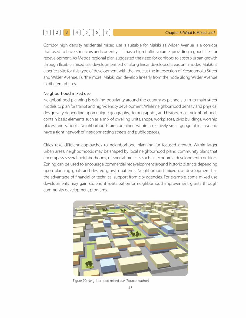
43
Chapter 3: What is Mixed use? 1 2 3 4 5 6 7
Neighborhood mixed use
Neighborhood planning is gaining popularity around the country as planners turn to main street
models to plan for transit and high-density development. While neighborhood density and physical
design vary depending upon unique geography, demographics, and history, most neighborhoods
contain basic elements such as a mix of dwelling units, shops, workplaces, civic buildings, worship
places, and schools. Neighborhoods are contained within a relatively small geographic area and
have a tight network of interconnecting streets and public spaces.
Cities take diff erent approaches to neighborhood planning for focused growth. Within larger
urban areas, neighborhoods may be shaped by local neighborhood plans, community plans that
encompass several neighborhoods, or special projects such as economic development corridors.
Zoning can be used to encourage commercial redevelopment around historic districts depending
upon planning goals and desired growth patterns. Neighborhood mixed use development has
the advantage of fi nancial or technical support from city agencies. For example, some mixed use
developments may gain storefront revitalization or neighborhood improvement grants through
community development programs.
Corridor high density residential mixed use is suitable for Makiki as Wilder Avenue is a corridor
that used to have streetcars and currently still has a high traffi c volume, providing a good sites for
redevelopment. As Metro’s regional plan suggested the need for corridors to absorb urban growth
through fl exible, mixed use development either along linear developed areas or in nodes, Makiki is
a perfect site for this type of development with the node at the intersection of Keeaoumoku Street
and Wilder Avenue. Furthermore, Makiki can develop linearly from the node along Wilder Avenue
in diff erent phases.
Figure 70: Neighborhood mixed use (Source: Author)

44
Chapter 3: What is Mixed use? 1 2 3 4 5 6 7
The location and individual character of a neighborhood mixed use center is often determined
by historic growth patterns, topography and transportation access. The mix of uses found in
buildings is determined by local demographics, local market conditions, and allowed usage. Like
all development, neighborhood mixed use must be responsive to market trends to capture local
business. The advantage of mixed use development in dense, established urban neighborhoods
comes from the number of households per acre and local buying power. The variety of needs in
traditional neighborhoods provides a ready market for many uses and increases the potential success
of mixed use. Urban neighborhoods may also have the advantage of traffi c corridors and transit that
bring customers from outside the immediate neighborhood. New mixed use development may
have diffi culty gaining approval because neighbors often voice objections to increased traffi c from
new retail or commercial uses. A primary step in neighborhood mixed use redevelopment is to gain
the support of the neighborhood.
Neighborhood mixed use is suitable for Makiki as Makiki has basic elements such as a mix of dwelling
units, parks, churches and schools. However, Makiki does not have enough retail stores. Mixed use
development will facilitate Makiki to have more retail stores and working opportunities within a
walking distance. Furthermore, the secondary feeder system from Ala Moana Would bring people
from outside Makiki.
Ve
rtic
al
Tow
n C
en
ter
Ad
ap
tive
Co
rrid
or
Ne
igh
bo
rho
od
Not so suitable for Makiki:
High-rise buildings may destroy the human scale of the friendly neighborhood.
Relatively suitable for Makiki:
Makiki could to be a new central urban area.
Suitable for Makiki in some areas:
There are some historical buildings that could be reused for other purposes.
Very suitable for Makiki:
Wilder Avenue could act as a corridor providing good sites for redevelopment.
Very suitable for Makiki:
Makiki has basic elements for a good neighborhood except for commercial facilities.

45
Chapter 3: What is Mixed use? 1 2 3 4 5 6 7
4. Advantages of mixed use
Throughout the late 20th century, it became obvious to many urban planners and other professionals
that mixed-use development had many benefi ts and should be promoted again. As American, British,
Canadian and Australian cities deindustrialized, the need to separate residences from dangerous
factories became less important. Completely separate zoning created isolated “islands” of each
type of development. In most cases, the automobile had become a requirement for transportation
between vast fi elds of residentially zoned housing and the separate commercial and offi ce strips,
creating issues of Automobile dependency. In 1961, Jane Jacobs’ infl uential The Death and Life of
Great American Cities argued that a mixture of uses is vital and necessary for a healthy urban area.
Zoning laws have been revised accordingly and increasingly attempt to address these problems
by using mixed-use zoning. A mixed use district will most commonly be the “downtown” of a local
community, ideally associated with public transit nodes in accordance with principles of Transit-
Oriented Development (TOD) and new urbanism. Mixed use guidelines often result in residential
buildings with street front commercial space. Retailers have the assurance that they will always have
customers living right above and around them, while residents have the benefi t of being able to
walk a short distance to get groceries and household items, or see a movie.
Diversity
The mixture of land uses encourages the diversity of environmental stimulation for residents. For
example, people who visit Makiki District Park would go to other destinations afterwards if there
were more places to eat or shop around the park. Mixed use promotes the sociability of the
neighborhood by providing a diversity of meeting places. It is important to enhance diversity at the
scale of the pedestrian.
Opportunity
Mixed use widens the choice of activity that is accessible to the residents by expanding the range
of environments that they can experience as a pedestrian. Mixed use also provides more working
opportunities for the residents within a walking distance as well as socializing opportunities.
Reduction of dependency upon the automobile
Mixed use enables the pedestrian to easily access goods and services. Current land use patterns
emphasize the separation of land uses and make it necessary to use the automobile for
transportation. Mixed use provides the option to walk by bringing destinations closer together. As
mixed use increases residential and employment densities, it also encourages the development of
mass transit. When the need for the automobile is reduced, problems such as gasoline consumption,
air pollution, noise, traffi c and parking are minimized.

46
Chapter 3: What is Mixed use? 1 2 3 4 5 6 7
Increase in land use effi ciency
It is effi cient to duplicate uses by extending the operational hours of a building. Mixed use allows
land or buildings to be used more intensively and for longer periods of time. For example, public
space in a building could be used for 24 hours if the building contained two uses with compatible
schedules such as restaurants and bars.
5. Disadvantages of mixed use
Mixed use development is seen as too risky by many developers and lending institutions because
economic success requires that the many diff erent uses all remain in business. Most development
throughout the mid to late 20th century was single-use, so many development and fi nance
professionals see this as the safer and more acceptable means to provide construction and earn
a profi t. Christopher B. Leinberger notes that there are 19 standard real estate product types that
can obtain easy fi nancing through real estate investment trusts. Each type, such as the offi ce park
and the strip mall, is designed for low density, single use zoning. Another issue is that short term
discounted cash fl ow has become the standard way to measure the success of income-producing
development, resulting in “disposable” suburban designs that make money in the short run but are
not as successful in the mid to long term as walkable, mixed use environments.
Mixed use commercial space is often seen as being best suited for retail and small offi ce uses.
This precludes its widespread adoption as the trend to ever-larger corporate and government
employment accelerates.
Figure 71: Example of Restaurant / Bar
(Source: Web - Google image)
Figure 72: Example of Restaurant / Bar
(Source: Web - Google image)

47
Chapter 3: What is Mixed use? 1 2 3 4 5 6 7
Mixed use residential buildings and neighborhoods are best suited to those who prefer public
amenities to private, regulated personal space. The lack of private outdoor space for kids and pets
is undesirable to some, particularly in some North American cultures because or their cultural
background of pioneer days and they are use to single family housing types with a back yard on
a large parcel of land. However, Makiki has a variety of cultural background including almost 50%
Asian people. Asian people are used to living on a limited land parcels and taking advantage of
public spaces.
Construction costs for mixed-use development currently exceed those for similar sized, single-use
buildings. Challenges include fi re separations, sound attenuation, ventilation, and egress. Leinberger
explains, “Good urban architecture costs upward of 50 percent more than typical suburban buildings. In
urban areas, residents and businesses demand a higher quality of building, since you are walking past
them, not driving by at 45 miles an hour with the buildings set back 150 feet.”
Additional costs arise from meeting the design needs. In some designs, the large, high-ceilinged,
columnless lower fl oor for commercial uses may not be entirely compatible with the smaller scale
of walled residential space above. Often the parking space requirements for businesses exceed
those of residential development. Thus, mixed use projects that are not sited close to public transit
are likely to require a large number of parking spaces that may be diffi cult to fi nance. It should
be noted however that in mixed-use developments in some denser areas, owning an automobile
might be considered a luxury rather than a necessity. A notable example in the United States would
Manhattan, though this is not a typical case.
Others maintain that modern consumers prefer big box retailers, as evidenced by the fact that
most grocery shoppers today would prefer the convenience of weekly shopping, as opposed to
picking up each day’s food items from a number of local shops. However, quality is sometimes more
important than quantity as a lot of residents in Hawaii go to farmer’s market in the early morning to
get fresh vegetables.

48
Chapter 4: Case studies of Mixed use and Great Public Places
1. Mixed use: Hillside Terrace - Tokyo, Japan
Background
The central areas in most of the cities in Japan including Tokyo consist of homogenized offi ce
and commercial buildings lacking in identity. Industrialized oceanfront has been taken over by
entertainment facilities such as theme parks in past twenty years, and road and railroad systems
have grown without any order. The architectural trend has shifted from public to commercial
building after the economic bubble in 1984 when a number of commercial buildings started win
architectural awards. Since then, the buildings designed by famous architects were randomly slotted
into the cities. In this way, a lot of the space in the cities is fi lled with chaotic buildings.
Although Japan had enough time and money to preserve their cultural city heritage, “instant cities”
consisted of modern shopping centers or offi ce buildings came along as a result of prioritizing the
way to make the cities grow effi ciently. Unfortunately, traditional urban form with Japanese old
community-based wooden houses or temples has been almost destroyed and they are losing their
identity. It is necessary to accept the fact caused by the rapid and large scale development, and to
consider a new way of creating the city space.
Figure 67: Tokyo (Source: Web - Google image) Figure 68: Tokyo (Source: Web - Google image)
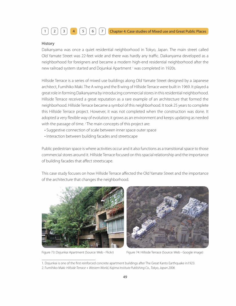
49
Chapter 4: Case studies of Mixed use and Great Public Places 1 2 3 4 5 6 7
History
Daikanyama was once a quiet residential neighborhood in Tokyo, Japan. The main street called
Old Yamate Street was 22-feet wide and there was hardly any traffi c. Daikanyama developed as a
neighborhood for foreigners and became a modern high-end residential neighborhood after the
new railroad system started and Dojunkai Apartment 1 was completed in 1920s.
Hillside Terrace is a series of mixed use buildings along Old Yamate Street designed by a Japanese
architect, Fumihiko Maki. The A wing and the B wing of Hillside Terrace were built in 1969. It played a
great role in forming Daikanyama by introducing commercial stores in this residential neighborhood.
Hillside Terrace received a great reputation as a rare example of an architecture that formed the
neighborhood. Hillside Terrace became a symbol of this neighborhood. It took 25 years to complete
this Hillside Terrace project. However, it was not completed when the construction was done. It
adopted a very fl exible way of evolution; it grows as an environment and keeps updating as needed
with the passage of time. 2 The main concepts of this project are:
• Suggestive connection of scale between inner space outer space
• Interaction between building facades and streetscape
Public pedestrian space is where activities occur and it also functions as a transitional space to those
commercial stores around it. Hillside Terrace focused on this spacial relationship and the importance
of building facades that aff ect streetscape.
This case study focuses on how Hillside Terrace aff ected the Old Yamate Street and the importance
of the architecture that changes the neighborhood.
_______________________________
1. Dojunkai is one of the fi rst reinforced concrete apartment buildings after The Great Kanto Earthquake in1923.
2. Fumihiko Maki: Hillside Terrace + Western World, Kajima Institute Publishing Co., Tokyo, Japan 2006
Figure 73: Dojunkai Apartment (Source: Web - Flickr) Figure 74: Hillside Terrace (Source: Web - Google image)

50
Chapter 4: Case studies of Mixed use and Great Public Places 1 2 3 4 5 6 7
It seems that the streetscape of Old Yamate Street is infl uenced by the change in building heights,
materials, and colors generated by the existence of Hillside Terrace. In order to understand the
impact of Hillside Terrace on facades of other buildings on Old Yamate Street, it is necessary to set
the building heights, materials, colors and arrangement and investigate how those factors infl uence
the facades of other buildings. The fi rst step is to examine whether Hillside Terrace itself has a certain
level of uniformity or not by investigating the facade of Hillside Terrace. The next step is to examine
the infl uence on this neighborhood by investigating the facades of other buildings on Old Yamate
Street.
Facades of Hillside Terrace
Basically, there is no commonality of the materials except for the facades of the wings built in the
same period of time. In order to enhance the atmosphere of the period of time, it seems that they
always tried to use the new and trendy materials such as tiles, bricks, stones, and glass blocks.
Although the facades have only a little use of glass, they do not provide the feeling of pressure
because the buildings have a lot of setback spaces. The area where glass is used is limited to the
commercial space on the fi rst fl oor faced on Old Yamate Street and windows for the residential
space on the upper fl oor are relatively small and just enough to collect the natural light.
Unlike the materials, colors are relatively uniform, although there are diff erent types of paint due to
the diff erent materials. One of the reasons for using beige or earthy colors in general is to achieve
the harmony with surrounding buildings and not to be overstated. Another reason is that it is simply
easy to repaint and relatively easy to keep the same color.
Figure 75: Facades of Hillside Terrace (Source: Web - Flickr)
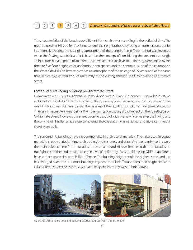
51
Chapter 4: Case studies of Mixed use and Great Public Places 1 2 3 4 5 6 7
The characteristics of the facades are diff erent from each other according to the period of time. The
method used for Hillside Terrace is not to form the neighborhood by using uniform facades, but by
intentionally creating the changing atmosphere of the period of time. This method was invented
when the D wing was built and it is based on the concept of considering the area not as a single
architecture, but as a group of architecture. However, a certain level of uniformity is enhanced by the
three to fi ve fl oor height, color uniformity, open spaces, and the continuous use of the columns on
the street side. Hillside Terrace provides an atmosphere of the passage of 25 years, and at the same
time, it creates a certain level of uniformity of the A wing through the G wing along Old Yamate
Street.
Facades of surrounding buildings on Old Yamate Street
Daikanyama was a quiet residential neighborhood with old wooden houses surrounded by stone
walls before this Hillside Terrace project. There were spaces between low-rise houses and the
neighborhood was not very dense. The facades of the buildings on Old Yamate Street started to
change in the past ten years. Before then, the gas station caused a bad impact on the streetscape on
Old Yamate Street. However, the street became beautiful with the new facades after the F wing and
the G wing of Hillside Terrace were completed, the gas station was removed, and more commercial
stores were built.
The surrounding buildings have no commonality in their use of materials. They also used in vogue
materials in each period of time such as tiles, bricks, stones, and glass. White or earthy colors were
the main color scheme for the facades in the area around Hillside Terrace so that the facades do
not fi ght each other and provide a certain level of uniformity. Most buildings on Old Yamate Street
have setback space similar to Hillside Terrace. The building heights could be higher as the land use
has changed over time, but most buildings adjacent to Hillside Terrace keep their height similar to
Hillside Terrace because they respect it and keep the harmony with Hillside Terrace.
Figure 76: Old Yamate Street and building facades (Source: Web - Google image)

52
Chapter 4: Case studies of Mixed use and Great Public Places 1 2 3 4 5 6 7
Transformation of the neighborhood
The retail stores in Hillside Terrace are selected by Fumihiko Maki. The turnover of the retail stores
in Hillside Terrace is relatively small and most of them are still there after 20 years. The quality of the
commercial use in Hillside Terrace is maintained by keeping the high quality retail stores strictly
selected by the architect. This quality stimulates other retails stores around it to improve their quality
as well.
Daikanyama was a quiet residential neighborhood with old wooden houses surrounded by
stone walls before this Hillside Terrace project. There were mostly single family houses along Old
Yamate Street in 1960s. As this project went on, single family houses were gradually converted into
commercial or mixed used buildings along the street in 1970s. Nowadays, there are only few single
family houses remaining on Old Yamate Street. The land use has been changed into mixed use and
small parcels for single family houses were consolidated to accommodate lager scale mixed use
development.
Spatial composition in Hillside Terrace
A network and diff erent width of paths, platforms, and stairs create a spacious leisurely ambiance
that leads pedestrians into the inner public space, with its courtyards, shops, and restaurants. At the
same time, the privacy and individuality of the residential space on the upper fl oor are ensured in
order to achieve the residential character associated with this neighborhood.
Figure 77: Diff erent spatial experience in Hillside Terrace (Source: Web - Flickr)
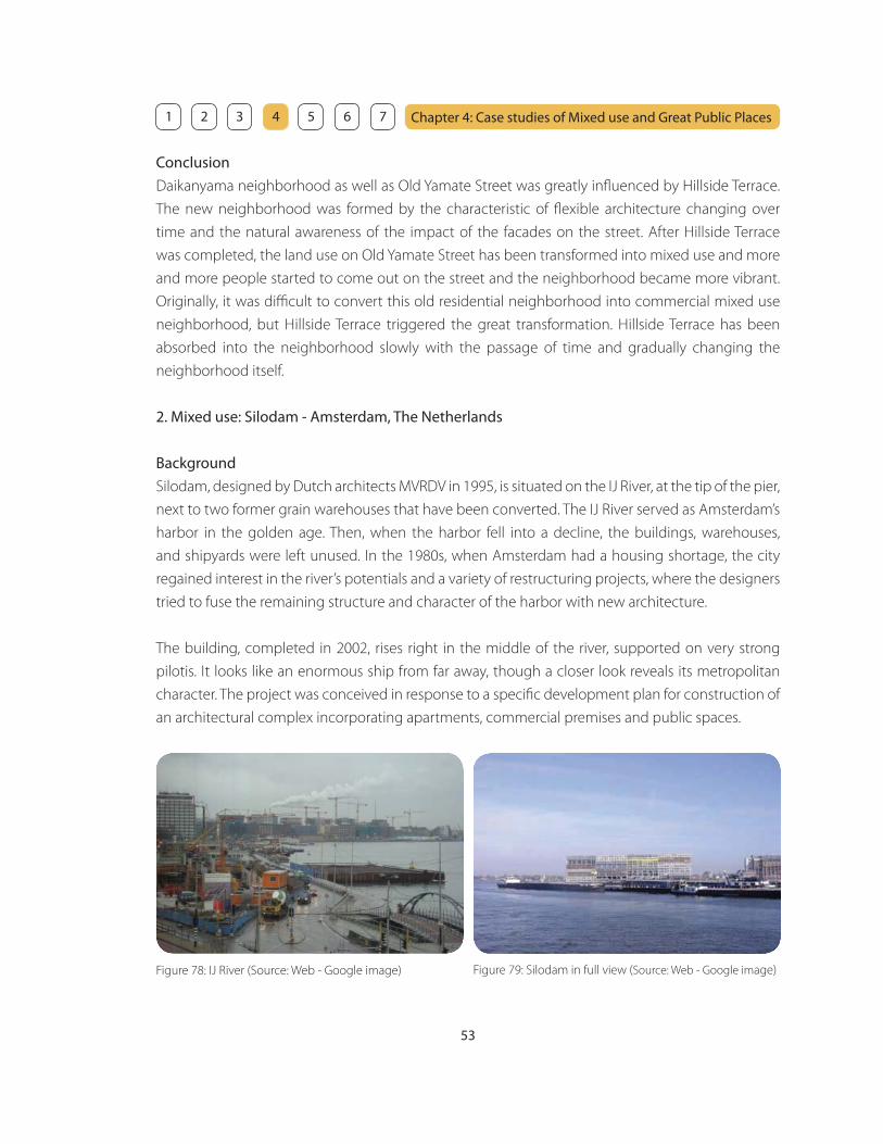
53
Chapter 4: Case studies of Mixed use and Great Public Places 1 2 3 4 5 6 7
Conclusion
Daikanyama neighborhood as well as Old Yamate Street was greatly infl uenced by Hillside Terrace.
The new neighborhood was formed by the characteristic of fl exible architecture changing over
time and the natural awareness of the impact of the facades on the street. After Hillside Terrace
was completed, the land use on Old Yamate Street has been transformed into mixed use and more
and more people started to come out on the street and the neighborhood became more vibrant.
Originally, it was diffi cult to convert this old residential neighborhood into commercial mixed use
neighborhood, but Hillside Terrace triggered the great transformation. Hillside Terrace has been
absorbed into the neighborhood slowly with the passage of time and gradually changing the
neighborhood itself.
2. Mixed use: Silodam - Amsterdam, The Netherlands
Background
Silodam, designed by Dutch architects MVRDV in 1995, is situated on the IJ River, at the tip of the pier,
next to two former grain warehouses that have been converted. The IJ River served as Amsterdam’s
harbor in the golden age. Then, when the harbor fell into a decline, the buildings, warehouses,
and shipyards were left unused. In the 1980s, when Amsterdam had a housing shortage, the city
regained interest in the river’s potentials and a variety of restructuring projects, where the designers
tried to fuse the remaining structure and character of the harbor with new architecture.
The building, completed in 2002, rises right in the middle of the river, supported on very strong
pilotis. It looks like an enormous ship from far away, though a closer look reveals its metropolitan
character. The project was conceived in response to a specifi c development plan for construction of
an architectural complex incorporating apartments, commercial premises and public spaces.
Figure 78: IJ River (Source: Web - Google image) Figure 79: Silodam in full view (Source: Web - Google image)
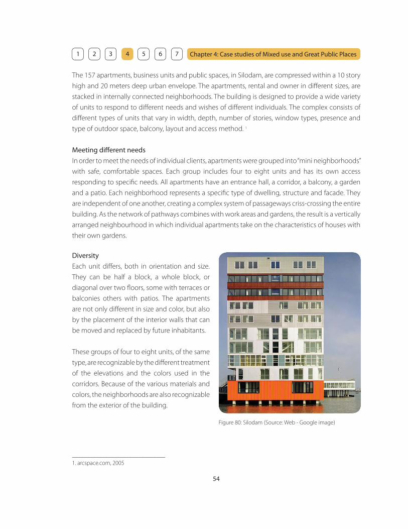
54
Chapter 4: Case studies of Mixed use and Great Public Places 1 2 3 4 5 6 7
The 157 apartments, business units and public spaces, in Silodam, are compressed within a 10 story
high and 20 meters deep urban envelope. The apartments, rental and owner in diff erent sizes, are
stacked in internally connected neighborhoods. The building is designed to provide a wide variety
of units to respond to diff erent needs and wishes of diff erent individuals. The complex consists of
diff erent types of units that vary in width, depth, number of stories, window types, presence and
type of outdoor space, balcony, layout and access method. 1
Meeting diff erent needs
In order to meet the needs of individual clients, apartments were grouped into “mini neighborhoods”
with safe, comfortable spaces. Each group includes four to eight units and has its own access
responding to specifi c needs. All apartments have an entrance hall, a corridor, a balcony, a garden
and a patio. Each neighborhood represents a specifi c type of dwelling, structure and facade. They
are independent of one another, creating a complex system of passageways criss-crossing the entire
building. As the network of pathways combines with work areas and gardens, the result is a vertically
arranged neighbourhood in which individual apartments take on the characteristics of houses with
their own gardens.
Diversity
Each unit diff ers, both in orientation and size.
They can be half a block, a whole block, or
diagonal over two fl oors, some with terraces or
balconies others with patios. The apartments
are not only diff erent in size and color, but also
by the placement of the interior walls that can
be moved and replaced by future inhabitants.
These groups of four to eight units, of the same
type, are recognizable by the diff erent treatment
of the elevations and the colors used in the
corridors. Because of the various materials and
colors, the neighborhoods are also recognizable
from the exterior of the building.
Figure 80: Silodam (Source: Web - Google image)
_______________________________
1. arcspace.com, 2005

55
Chapter 4: Case studies of Mixed use and Great Public Places 1 2 3 4 5 6 7
Figure 81: The wide passageway
(Source: Web - Google image)
Spatial experience
The commercial and public areas are not located exclusively on the lower fl oors, but distributed at
all levels of the building. On the west side of the building, the base of the structure is penetrated
with a wide passageway that leads to a pubicly accessible balcony, with magnifi cent views of the IJ,
that can be used by all residents. The business spaces underneath the balcony share the same views.
Residents can walk through the building passing diff erent facades and roof tops, under the building
through the hall to the terrace, or along the marina where boats can be docked.
Figure 82: The marina
(Source: Web - Google image)
Conclusion
Silodam is an example of truly innovative architecture expressing a new concept of spatial
development which few architects have attempted so far, in which premises are arranged
not only horizontally but on a vertical basis too, with fl oors that fold and intersect with one
another with the utmost fl exibility. Solidam is a great outcome of urban development themes
relating to high population density, giving rise to designs that make optimal use of all available
space.
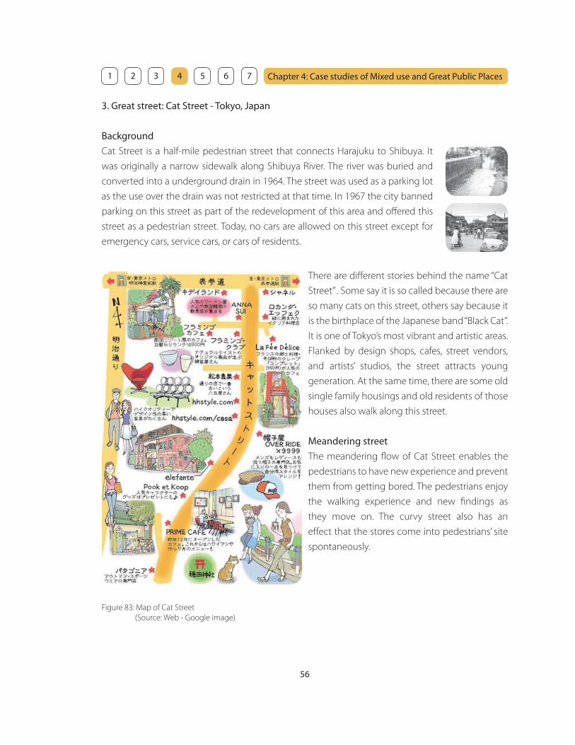
56
Chapter 4: Case studies of Mixed use and Great Public Places 1 2 3 4 5 6 7
3. Great street: Cat Street - Tokyo, Japan
Background
Cat Street is a half-mile pedestrian street that connects Harajuku to Shibuya. It
was originally a narrow sidewalk along Shibuya River. The river was buried and
converted into a underground drain in 1964. The street was used as a parking lot
as the use over the drain was not restricted at that time. In 1967 the city banned
parking on this street as part of the redevelopment of this area and off ered this
street as a pedestrian street. Today, no cars are allowed on this street except for
emergency cars, service cars, or cars of residents.
Figure 83: Map of Cat Street
(Source: Web - Google image)
There are diff erent stories behind the name “Cat
Street” . Some say it is so called because there are
so many cats on this street, others say because it
is the birthplace of the Japanese band “Black Cat”.
It is one of Tokyo’s most vibrant and artistic areas.
Flanked by design shops, cafes, street vendors,
and artists’ studios, the street attracts young
generation. At the same time, there are some old
single family housings and old residents of those
houses also walk along this street.
Meandering street
The meandering fl ow of Cat Street enables the
pedestrians to have new experience and prevent
them from getting bored. The pedestrians enjoy
the walking experience and new fi ndings as
they move on. The curvy street also has an
eff ect that the stores come into pedestrians’ site
spontaneously.

57
Chapter 4: Case studies of Mixed use and Great Public Places 1 2 3 4 5 6 7
Variety of options
Cat Street has an intimate scale that brings pedestrians into close contact with the attractive
storefronts. The walking experience on this street is exciting because there are so many diff erent
options next to each other. Pedestrians can fi nd almost anything in diff erent retail stores such
as clothes, shoes, hats, glasses, bags, furniture, books or plants. When pedestrians get tired from
shopping, there are many cafes and restaurants to take a rest. Another interesting fact is that the
guardrails appear to pedestrians as “seating” rather than as “protective barriers,” that they are eff ective
in promoting comfort.
Figure 84: Cat Street (Source: Web - Google image) Figure 85: Cat Street (Source: Web - Google image)

58
Chapter 4: Case studies of Mixed use and Great Public Places 1 2 3 4 5 6 7
4. Great Street: Portobello Road - London, England
Background
Portobello Road is a road in the Notting Hill district of the Royal Borough of Kensington and Chelsea
in west London, England. It runs almost the length of Notting Hill from south to north, roughly
parallel with Ladbroke Grove. On Saturdays it is home to Portobello Road Market, one of London’s
notable street markets, known for its second-hand clothes and antiques, and for the location of one
of the scenes in Bedknobs and Broomsticks. Every August since 1996 the Portobello Film Festival has
been held in locations around Portobello Road.
History
Portobello Road is a construct of the Victorian era. Before about 1850, it was little more than a
country lane connecting Portobello Farm with Kensal Green in the north and what is today Notting
Hill in the south. Much of it consisted of hay fi elds, orchards and other open land. The road ultimately
took form piecemeal in the second half of the nineteenth century, nestling between the large
new residential developments of Paddington and Notting Hill. Its shops and markets thrived on
serving the wealthy inhabitants of the elegant crescents and terraces that sprang up around it, and
its working class residents found employment in the immediate vicinity as construction workers,
domestic servants, coachmen, messengers, tradesmen and costermongers. 1 After the Hammersmith
and City Railway line was completed in 1864, and Ladbroke Grove station opened, the northern end
of Portobello Road was also developed, and the last of the open fi elds disappeared under brick and
concrete. George Orwell lived in Portobello Road in the winter of 1927 after resigning as Assistant
Superintendent of the Indian Imperial Police in Burma. 2
_______________________________
1. A consermonger was a street seller of fruit and vegetables
2. British History website
Figure 86: Portobello Road (Source: Author) Figure 87: Antique store on Portobello Road (Source: Author)
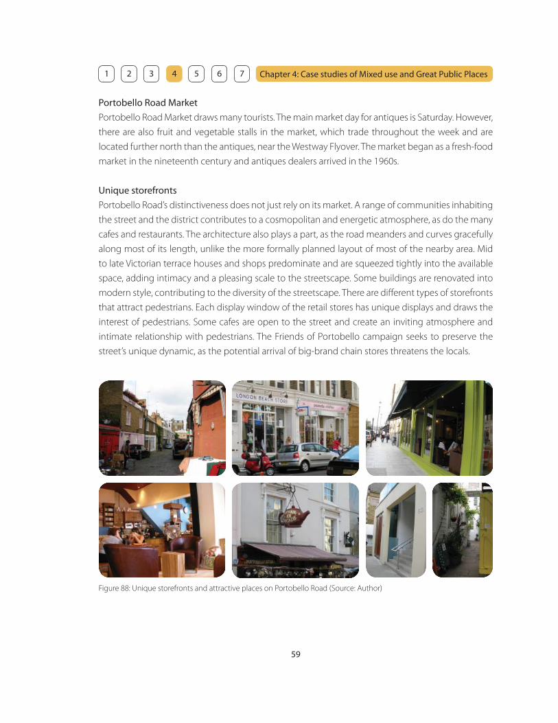
59
Chapter 4: Case studies of Mixed use and Great Public Places 1 2 3 4 5 6 7
Portobello Road Market
Portobello Road Market draws many tourists. The main market day for antiques is Saturday. However,
there are also fruit and vegetable stalls in the market, which trade throughout the week and are
located further north than the antiques, near the Westway Flyover. The market began as a fresh-food
market in the nineteenth century and antiques dealers arrived in the 1960s.
Unique storefronts
Portobello Road’s distinctiveness does not just rely on its market. A range of communities inhabiting
the street and the district contributes to a cosmopolitan and energetic atmosphere, as do the many
cafes and restaurants. The architecture also plays a part, as the road meanders and curves gracefully
along most of its length, unlike the more formally planned layout of most of the nearby area. Mid
to late Victorian terrace houses and shops predominate and are squeezed tightly into the available
space, adding intimacy and a pleasing scale to the streetscape. Some buildings are renovated into
modern style, contributing to the diversity of the streetscape. There are diff erent types of storefronts
that attract pedestrians. Each display window of the retail stores has unique displays and draws the
interest of pedestrians. Some cafes are open to the street and create an inviting atmosphere and
intimate relationship with pedestrians. The Friends of Portobello campaign seeks to preserve the
street’s unique dynamic, as the potential arrival of big-brand chain stores threatens the locals.
Figure 88: Unique storefronts and attractive places on Portobello Road (Source: Author)

60
Chapter 4: Case studies of Mixed use and Great Public Places 1 2 3 4 5 6 7
5. Great Community garden: Liz Christy Garden - New York, NY
Background
Liz Christy Garden is the oldest community garden in New York
City that has rare plants and a wonderful pond. The garden has
rare plants and a wonderful fi sh and turtle pond.
In 1973 a local resident named Liz Christy and a group of gardening
activists known as the Green Guerillas were planting window
boxes, vacant lots with “seed bombs” and tree pits in the area.
They saw the large rubble-strewn lot as a potential garden and in
December, they went to the City to fi nd a way to gain offi cial use
of the land. Volunteers hauled the garbage and rubble out, spread
donated topsoil, installed a fence and began planting. This was
the beginning of the garden. 1
Figure 90: Liz Christy Garden (Source: Web - Flickr)
On April 23, 1974, the City’s offi ce of Housing Preservation and Development approved the site for
rental as the “Bowery Houston Community Farm and Garden” for $1 a month. Sixty raised beds were
planted with vegetables, and then trees and herbaceous borders were added.
In 1986 the Garden was dedicated as the Liz Christy’s Bowery-Houston Garden, in memory of its
founder. In 1990, after years of uncertainty and a ground swell of support, the local development
group, the Cooper Square Committee, pledged to preserve the garden for the neighborhood.
Figure 89: Entry of Liz Christy Garden
(Source: Web - Flickr)
_______________________________
1. Liz Christy Garden offi cial Website
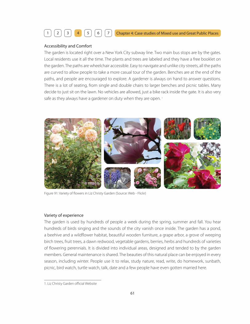
61
Chapter 4: Case studies of Mixed use and Great Public Places 1 2 3 4 5 6 7
Variety of experience
The garden is used by hundreds of people a week during the spring, summer and fall. You hear
hundreds of birds singing and the sounds of the city vanish once inside. The garden has a pond,
a beehive and a wildfl ower habitat, beautiful wooden furniture, a grape arbor, a grove of weeping
birch trees, fruit trees, a dawn redwood, vegetable gardens, berries, herbs and hundreds of varieties
of fl owering perennials. It is divided into individual areas, designed and tended to by the garden
members. General maintenance is shared. The beauties of this natural place can be enjoyed in every
season, including winter. People use it to relax, study nature, read, write, do homework, sunbath,
picnic, bird watch, turtle watch, talk, date and a few people have even gotten married here.
Accessibility and Comfort
The garden is located right over a New York City subway line. Two main bus stops are by the gates.
Local residents use it all the time. The plants and trees are labeled and they have a free booklet on
the garden. The paths are wheelchair accessible. Easy to navigate and unlike city streets, all the paths
are curved to allow people to take a more casual tour of the garden. Benches are at the end of the
paths, and people are encouraged to explore. A gardener is always on hand to answer questions.
There is a lot of seating, from single and double chairs to larger benches and picnic tables. Many
decide to just sit on the lawn. No vehicles are allowed, just a bike rack inside the gate. It is also very
safe as they always have a gardener on duty when they are open. 1
_______________________________
1. Liz Christy Garden offi cial Website
Figure 91: Variety of fl owers in Liz Christy Garden (Source: Web - Flickr)
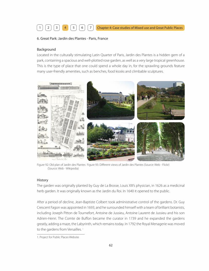
62
Chapter 4: Case studies of Mixed use and Great Public Places 1 2 3 4 5 6 7
6. Great Park: Jardin des Plantes - Paris, France
Background
Located in the culturally stimulating Latin Quarter of Paris, Jardin des Plantes is a hidden gem of a
park, containing a spacious and well-plotted rose garden, as well as a very large tropical greenhouse.
This is the type of place that one could spend a whole day in, for the sprawling grounds feature
many user-friendly amenities, such as benches, food kiosks and climbable sculptures.
Figure 92: Old plan of Jardin des Plantes
(Source: Web - Wikipedia)
Figure 93: Diff erent views of Jardin des Plantes (Source: Web - Flickr)
History
The garden was originally planted by Guy de La Brosse, Louis XIII’s physician, in 1626 as a medicinal
herb garden. It was originally known as the Jardin du Roi. In 1640 it opened to the public.
After a period of decline, Jean-Baptiste Colbert took administrative control of the gardens. Dr. Guy
Crescent Fagon was appointed in 1693, and he surrounded himself with a team of brilliant botanists,
including Joseph Pitton de Tournefort, Antoine de Jussieu, Antoine Laurent de Jussieu and his son
Adrien-Henri. The Comte de Buff on became the curator in 1739 and he expanded the gardens
greatly, adding a maze, the Labyrinth, which remains today. In 1792 the Royal Menagerie was moved
to the gardens from Versailles. 1
_______________________________
1. Project for Public Places Website

63
Chapter 4: Case studies of Mixed use and Great Public Places 1 2 3 4 5 6 7
Accessibility
This park is at the heart of a wonderful location. One entrance is directly across the street from La
Mosquee, a mosque converted into a full-service spa, which serves fabulous tea and pastries in its
outdoor garden and indoor lounge. The park is accessible by foot, and is only a few blocks from the
Jussieu metro station, which is located across the street from Paris VII, a school of La Sorbonne. Other
attractions near the park include the Arabian Institute, with its landmark windows, and of course, the
Left Bank of the Seine.
Variety of activities
Jardin des Plantes provides all the amenities for the visitors such as food kiosks, public restrooms,
a warm retreat (the greenhouse), and ample seating. As is the case with most Parisian parks, Jardin
des Plantes is very clean, with many wastebaskets scattered throughout. Due to its highly populated
neighborhood, security is never an issue, and the park is open to foot traffi c only.
The park also has the Museum National d’Histoire Naturelle which is made up of four galleries. In
addition to the gardens and museums, there is also an aquarium and a small zoo, founded in 1795
by Bernardin de Saint-Pierre from animals of the royal menagerie at Versailles.1
The park is never empty throughout all seasons. It is a place that appeals to all age ranges, from the
very young to the elderly. It is also a wonderful place to learn about botany, with the many species
of plants clearly labeled and described. Because of its proximity to the Arabian Institute and La
Mosquee, users of Jardin des Plantes are of a range of ethnicities and cultural backgrounds.
Figure 94: Diff erent activities in Jardin des Plantes (Source: Web - Flickr)
_______________________________
1. Jardin des Plantes offi cial Website
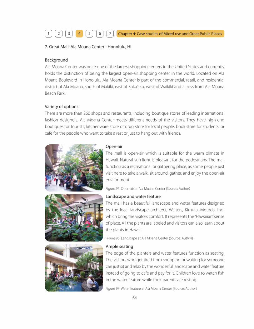
64
Chapter 4: Case studies of Mixed use and Great Public Places 1 2 3 4 5 6 7
7. Great Mall: Ala Moana Center - Honolulu, HI
Background
Ala Moana Center was once one of the largest shopping centers in the United States and currently
holds the distinction of being the largest open-air shopping center in the world. Located on Ala
Moana Boulevard in Honolulu, Ala Moana Center is part of the commercial, retail, and residential
district of Ala Moana, south of Makiki, east of Kaka’ako, west of Waikīkī and across from Ala Moana
Beach Park.
Variety of options
There are more than 260 shops and restaurants, including boutique stores of leading international
fashion designers. Ala Moana Center meets diff erent needs of the visitors. They have high-end
boutiques for tourists, kitchenware store or drug store for local people, book store for students, or
cafe for the people who want to take a rest or just to hang out with friends.
Open-air
The mall is open-air which is suitable for the warm climate in
Hawaii. Natural sun light is pleasant for the pedestrians. The mall
function as a recreational or gathering place, as some people just
visit here to take a walk, sit around, gather, and enjoy the open-air
environment.
Ample seating
The edge of the planters and water features function as seating.
The visitors who get tired from shopping or waiting for someone
can just sit and relax by the wonderful landscape and water feature
instead of going to cafe and pay for it. Children love to watch fi sh
in the water feature while their parents are resting.
Landscape and water feature
The mall has a beautiful landscape and water features designed
by the local landscape architect, Walters, Kimura, Motoda, Inc.,
which bring the visitors comfort. It represents the “Hawaiian” sense
of place. All the plants are labeled and visitors can also learn about
the plants in Hawaii.
Figure 97: Water feature at Ala Moana Center (Source: Author)
Figure 96: Landscape at Ala Moana Center (Source: Author)
Figure 95: Open-air at Ala Moana Center (Source: Author)

65
Chapter 4: Case studies of Mixed use and Great Public Places 1 2 3 4 5 6 7
8. Great Mall: Waikiki Beach Walk - Honolulu, HI
Background
Waikiki Beach Walk is the largest development project in Waikiki’s history. Nearly eight acres along
well traversed Lewers Street has been completely rebuilt and transformed into a colorful and spirited
showcase. It is an energetic, inviting, eclectic and exciting gathering place for the new Waikiki.
Waikiki Beach Walk is an impressive, new leisure destination to play and to stay. Benefi ting from the
island’s cooling trade winds and year-round excellent weather, an outdoor entertainment plaza,
nearly 50 new retailers, 16 dining establishments, and 5 hotels welcome both tourists and local
people, redefi ning the Waikiki experience.
Respecting the culture
Waikiki has a spiritual and social signifi cance. Waikiki Beach Walk
honors this with a meaningful design exploring the traditional
connection between water, land and people that celebrate
Hawaii’s ocean heritage. Visitors can discover an ideal expression of
Hawaii today. It is a place where people come to experience warm
hospitality, a rich confl uence of cultures and nature’s precious gifts
from land and sea.
The design concept incorporates the Hawaiian outrigger canoe
and Hawaii’s intimate relationship with the ocean. The wavy shaped
glass canopies over the outdoor plaza take their inspiration from
the movement of the sea, and supporting beams are reminiscent
of the `iako (booms) and ama (fl oat) of the outrigger canoe. The
canopies are lighted to create a beautifully illuminated contrast to
the night sky. 1
Landscape also plays a great role representing the Hawaiian
sense of place. The great lawn area with a shooting water feature
functions as a play ground for children. Coconut grove provides
an atmosphere of Hawaiian nature.
Figure 98, 99, and 100: Waikiki Beach Walk
(Source: Author)_______________________________
1. Waikiki Beach Walk offi cial Website

66
Chapter 4: Case studies of Mixed use and Great Public Places 1 2 3 4 5 6 7
9. Great Cafe: Starbucks at Ward- Honolulu, HI
Background
Starbucks is a dominant multinational coff eehouse chain based in the United States. Starbucks is the
largest coff eehouse company in the world, with 7,521 company-owned and 5,647 licensed stores in
40 countries, making a total of 13,168 stores worldwide. In the 1990’s, the company was opening a
new store every workday, a pace that continued into the 2000’s. Domestic growth has since slowed
down, though the company continues to expand in foreign markets and is opening 7 stores a day
worldwide. 1 You can see Starbucks almost everywhere you go. They just provide coff ee and some
snacks, but they are very popular.
Starbucks at Ward is located at the corner of Ward Avenue and Auahi Street, across from Ward
Warehouse. It is always well occupied with variety range of generations, no matter what the time or
day of the week.
The third place
Starbucks is a “third place” (besides home and work) to spend time, and store design is intended
to achieve this environment. There are four areas for diff erent needs of the customers. First area
is like a living room with comfortable couches where people can relax and enjoy their informal
conversation. Second area is a regular cafe setting with tables and hard-backed chairs where people
can read, write, or have casual business meetings. Third area is like a study room with a desk and
light where people can plug in your computer and study. Forth area is outdoor seating area where
people can escape from air conditioned room and enjoy the open air environment. One of the
factors that makes this place popular is that there are diff erent choices of the third place settings for
diff erent purposes.
Figure 101: Outdoor seating area
(Source: Author)
Figure 102: Regular cafe setting
(Source: Author)
Figure 103: Study area with a desk
(Source: Author)
_______________________________
1. Strarbucks offi cial Website
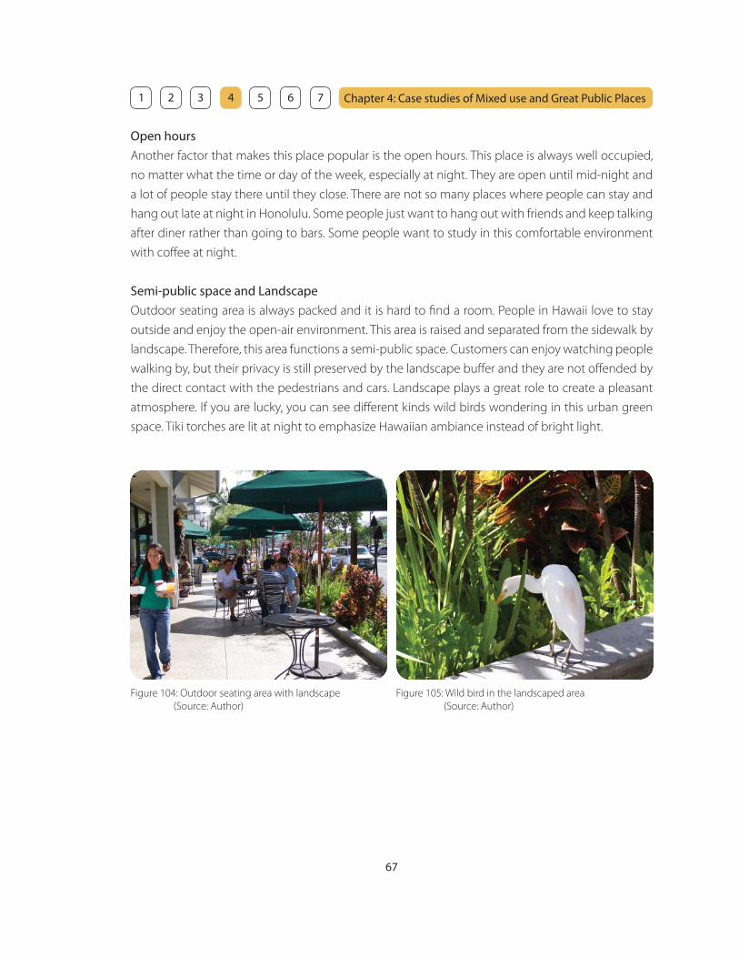
67
Chapter 4: Case studies of Mixed use and Great Public Places 1 2 3 4 5 6 7
Open hours
Another factor that makes this place popular is the open hours. This place is always well occupied,
no matter what the time or day of the week, especially at night. They are open until mid-night and
a lot of people stay there until they close. There are not so many places where people can stay and
hang out late at night in Honolulu. Some people just want to hang out with friends and keep talking
after diner rather than going to bars. Some people want to study in this comfortable environment
with coff ee at night.
Semi-public space and Landscape
Outdoor seating area is always packed and it is hard to fi nd a room. People in Hawaii love to stay
outside and enjoy the open-air environment. This area is raised and separated from the sidewalk by
landscape. Therefore, this area functions a semi-public space. Customers can enjoy watching people
walking by, but their privacy is still preserved by the landscape buff er and they are not off ended by
the direct contact with the pedestrians and cars. Landscape plays a great role to create a pleasant
atmosphere. If you are lucky, you can see diff erent kinds wild birds wondering in this urban green
space. Tiki torches are lit at night to emphasize Hawaiian ambiance instead of bright light.
Figure 104: Outdoor seating area with landscape
(Source: Author)
Figure 105: Wild bird in the landscaped area
(Source: Author)

68
Chapter 4: Case studies of Mixed use and Great Public Places 1 2 3 4 5 6 7
10. Great Cafe: Coff ee Line - Honolulu, HI
Background
Coff ee Line is situated in YMCA building across from University of Hawaii at Manoa. It is occupied
with the students and faculty at the University. It is a place for them to have coff ee or lunch, gather,
and share their ideas.
Figure 106: Order counter at Coff ee Line (Source: Author) Figure 107: Cafe space at Coff ee Line (Source: Author)
Owner’s pride
Denis, the owner of Coff ee Line prepares everything by himself. His
food is simple, but his commitment to his work provides a good
quality. You can tell his pride from his kitchen full with diff erent
kitchenware and tools. Customers love his food and most of them
come to Coff ee Line regularly.
Figure 108: Denis’ kitchen (Source: Author)
Semi-open space
The main cafe space is in a semi-open space with a high ceiling
providing natural sun light and the “openness” feeling. The space
is fi lled with diff erent plants and you feel like you are having
coff ee in a jungle. Diff erent shapes and colors of tables and chairs,
which Denis collected from diff erent people and places, gives an
interesting eclectic feeling.
Figure 109: Semi-open space at Coff ee Line (Source: Author)

69
Chapter 4: Case studies of Mixed use and Great Public Places 1 2 3 4 5 6 7
Outdoor seating area
Coff ee Line also has outdoor seating area surrounded by many
plants. This space does not face the sidewalk and provides privacy
for people who want to enjoy peace in a hidden garden.
Figure 110: Outdoor seating area at Coff ee Line (Source: Author)
Sharing art and cultures
Coff ee Line is a great place to share cultures. There is a bulletin board full with art and cultural
information such as art galleries, cultural events, or interesting lectures. There are many magazines
for customers to read. The topic range of the magazines are amazing such as architecture, traveling,
painting, sculpture, or computer graphics. Denis also hangs paintings done by art students at
University of Hawaii and it is a great opportunity for the painters to display their art in public. Denis
collects a number of interesting weird things such as old scale, microscope, instruments, or things
you cannot even tell what it is. It is like an antique store and it is just fun to be there and fi nd out
what is there. Coff ee Line is not just a place to have coff ee or lunch, but it is a place for people to
gather, interact, get information, fi nd new things, and share art and cultures.
Figure 111: Bulletin board at Coff ee Line
(Source: Author)
Figure 112: Magazines at Coff ee Line
(Source: Author)
Figure 113: Paintings at Coff ee Line
(Source: Author)

70
Chapter 4: Case studies of Mixed use and Great Public Places 1 2 3 4 5 6 7
11. Great Workplace: Paragraph - New York, NY
Background
Paragraph is dedicated to providing an aff ordable and tranquil working environment for writers of
all genres. It is located on 14th street between Fifth and Sixth Avenues, close to Union Square. It is
open 24 hours a day, 7 days a week, 365 days a year. Paragraph was created by writers for writers,
with an understanding that writers work best in a quiet, comfortable space away from the hurry and
obligation of urban life.
Paragraph is founded by Lila Cecil and Joy Parisi. They met at The New School’s graduate creative
writing program. Tired of slogging it out in jobs they did not have their hearts in and desperate for
a quiet place to write and a community of writers similar to the one they had found in graduate
school, they decided to open their own writing center.
The space for specifi c needs
Paragraph occupies the entire top fl oor of a three-story building. The 2500 sq. ft. loft space is divided
into two areas; a writing room and a kitchen and lounge area. The writing room has 38 partitioned
desks where writers work in a quiet relaxed atmosphere. Workspaces provide a feeling of privacy,
each with blocked sight lines from other working writers.
There is a couch in front of the fi replace for those who want to take a break from the page. A spiral
staircase leads up to the balcony with a library of books and a comfortable chair. The kitchen and
lounge area is in the rear of the space and contains a kitchenette, a large round table and smaller
cafe tables. There is a refrigerator and cabinets to store food, as well as a microwave, toaster oven
and coff ee maker. High-speed, wireless internet access is available throughout the space, as well as
a laser printer for members to use. 1
_______________________________
1. Paragraph offi cial Website
Figure 114: Diff erent spaces at Paragraph (Source: Paragraph offi cial website)

71
Chapter 4: Case studies of Mixed use and Great Public Places 1 2 3 4 5 6 7
12. What makes an identity?
What makes an identity? And what kind of an identity does Makiki need? It is important that an
identity should be timeless and able to change over time. Therefore, Makiki needs places where an
identity can grow over time through mixed use development. Identity should evolve, but not be
applied. For example, it is not eff ective to create a Japan Town just because the dominant cultural
background in Makiki is Japanese now. Trends change over time. In the future, Chinese or Korean
may become dominant culture in Makiki.
From the case studies, an identity is achieved by diff erent factors. Three important factors that make
an identity are culture, public space, and activities. These factors can be measured by fi ve basic
elements; diversity, experience, appearance, comfort, and fl exibility. The graphics below is a tool to
describe an identity. Each element has a measurement barometer of 1 through 10. (1 = poor, 5 =
average, 10 = excellent) In order to understand what an identity for a place is, it is eff ective to look at
some of the case studies and evaluate them by using this tool.
Figure 115: Three factors of an identity; Culture, Public space, and Activities (Source: Author)
Each factor consists of diff erent ingredients.
Culture
Public space
Activities
People • Architecture • Art • History • Food • Music • Plants • Language ...etc.
Landscape • Storefront • Facade • Sidewalk • Seating • Lighting ...etc.
Walk • Talk • Gather • Meet • Watch • Find • Eat • Shop • Play • Study • Work ...etc.

72
Chapter 4: Case studies of Mixed use and Great Public Places 1 2 3 4 5 6 7
Figure 116: Makiki - Three factors of the identity; Culture, Public space, and Activities (Source: Author)
The people in Makiki have diverse cultural background and consist of Japanese, White,
Chinese, Korean, Hawaiian, Filipino, Vietnamese, Black, Mixed, and others. - 10 points
Identity of MakikiC
ultu
re
Div
ersi
tyEx
per
ienc
eA
pp
eara
nce
Com
fort
Flex
ibili
ty
However, you cannot experience the cultural diversity. There are only few Asian food
restaurants. - 3 points
There is no place for people with specifi c cultural background where they can go and
feel comfortable. - 1 point
There is no fl exibility to allow diff erent cultures to grow in Makiki. Parks can be one of
a fl exible places to have diff erent cultural events, but Makiki District Park is never used
for those purposes. - 1 point
It is hard to tell the cultural diversity in Makiki by the appearance of the entire
neighborhood except for some historical buildings on Wilder Avenue. - 1 point

73
Chapter 4: Case studies of Mixed use and Great Public Places 1 2 3 4 5 6 7
There is not enough public space. Makiki District Park and Makiki Shopping Village are
the only places where people can go and interact each other. - 3 points
Pub
lic s
pac
e
Div
ersi
tyEx
per
ienc
eA
pp
eara
nce
Com
fort
Flex
ibili
ty
Walking experience is not pleasant on Wilder Avenue because the sidewalk is narrow
and the street is not well landscaped. - 3 points
Makiki District Park is well occupied, but there is not enough seating for people to
take a rest and relax after the activities. It is not comfortable to walk on the sidewalk
because it is narrow and it does not provide enough shading. - 1 point
The sidewalk is narrow and it does not have fl exibility to allow diff erent events to
occur such as street performance. - 1 point
Appearance of Makiki is not attractive. There are a number of old and shabby low-rise
apartments along Wilder Avenue. A lot of buildings are oriented sideways and the
blank walls are facing the street. - 1 point
There are diff erent activities in Makiki District Park such as gardening, soccer, basketball,
tennis, swimming or skateboarding. However, Makiki needs more place where people
can have a variety of activities. - 3 points
Act
iviti
es
Div
ersi
tyEx
per
ienc
eA
pp
eara
nce
Com
fort
Flex
ibili
ty
The experience is limited to the activities in Makiki District Park and small amount of
shopping at Makiki Shopping Village. - 3 points
Makiki District Park provides a comfortable environment for the diff erent activities
surrounded by some landscape. However, safety is an issue at night. - 2 points
The lawn area of Makiki District Park is fl exible to allow diff erent activities to occur
such as soccer, football, running, and playgrounds for children. However, it is the only
place that allow the fl exibility of activities in Makiki. - 1 point
Since the activity area is limited, Wilder Avenue does not look vibrant at all. It is
unfortunate that the half of the facades of Makiki Shopping Village is blank with few
openings and it is hard to see the activities happening there. - 1 point
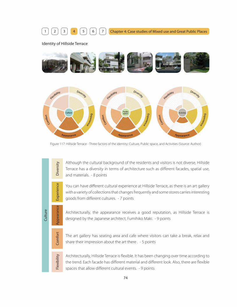
74
Chapter 4: Case studies of Mixed use and Great Public Places 1 2 3 4 5 6 7
Identity of Hillside Terrace
Figure 117: Hillside Terrace - Three factors of the identity; Culture, Public space, and Activities (Source: Author)
Although the cultural background of the residents and visitors is not diverse, Hillside
Terrace has a diversity in terms of architecture such as diff erent facades, spatial use,
and materials. - 8 points
Cul
ture
Div
ersi
tyEx
per
ienc
eA
pp
eara
nce
Com
fort
Flex
ibili
ty
You can have diff erent cultural experience at Hillside Terrace, as there is an art gallery
with a variety of collections that changes frequently and some stores carries interesting
goods from diff erent cultures. - 7 points
The art gallery has seating area and cafe where visitors can take a break, relax and
share their impression about the art there . - 5 points
Architecturally, Hillside Terrace is fl exible. It has been changing over time according to
the trend. Each facade has diff erent material and diff erent look. Also, there are fl exible
spaces that allow diff erent cultural events. - 9 points
Architecturally, the appearance receives a good reputation, as Hillside Terrace is
designed by the Japanese architect, Fumihiko Maki. - 9 points

75
Chapter 4: Case studies of Mixed use and Great Public Places 1 2 3 4 5 6 7
Hillside Terrace has a variety of ingredients of public space such as path, platforms,
stairs, seating area, and courtyards. - 8 points
Pub
lic s
pac
e
Div
ersi
tyEx
per
ienc
eA
pp
eara
nce
Com
fort
Flex
ibili
ty
A network and diff erent width of paths, platforms, and stairs create a spacious leisurely
experience that leads pedestrians into the inner public space, with its courtyards,
shops, and restaurants. - 8 points
There are many places to sit down and relax such as seating area, cafe, and restaurant.
Also, the landscape provides shade and comfortable atmosphere for the residents
and the visitors. - 7 points
The fl exible space is limited to the gallery area, but courtyards are sometimes used for
occasional events. - 3 points
The public space appearance of Hillside Terrace is attractive. The courtyards are
especially pleasing. Some are beautifully tiled, others are well landscaped. - 9 points
The activities are relatively diverse at Hillside Terrace. You can walk, shop, eat, or enjoy
art. People also work there, as there are some offi ce space in the complex. - 6 points
Act
iviti
es
Div
ersi
tyEx
per
ienc
eA
pp
eara
nce
Com
fort
Flex
ibili
ty
As all the retail stores are strictly selected by the architect, Hillside Terrace has a high
quality of diff erent experiences. - 7 points
The high quality of spaces provide a comfortable activities for the residents and the
visitors . - 6 points
Again, the space for fl exible activities such as performance or events is limited to the
gallery area and the courtyards. - 2 points
Since a lot of public spaces are situated in the inner space, it is hard to see the activities
from the street. However, it works well at Hillside Terrace because path and stairs draw
people in. - 4 points
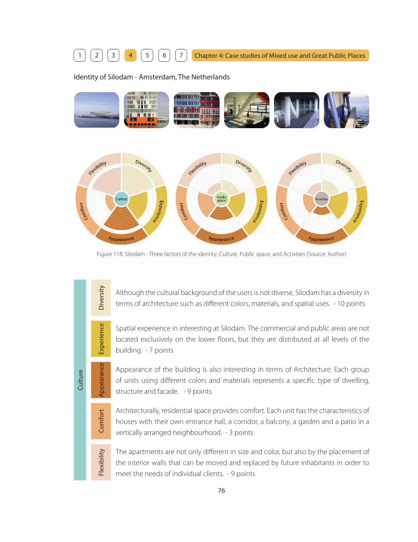
76
Chapter 4: Case studies of Mixed use and Great Public Places 1 2 3 4 5 6 7
Identity of Silodam - Amsterdam, The Netherlands
Although the cultural background of the users is not diverse, Silodam has a diversity in
terms of architecture such as diff erent colors, materials, and spatial uses. - 10 points
Cul
ture
Div
ersi
tyEx
per
ienc
eA
pp
eara
nce
Com
fort
Flex
ibili
ty
Spatial experience in interesting at Silodam. The commercial and public areas are not
located exclusively on the lower fl oors, but they are distributed at all levels of the
building. - 7 points
Architecturally, residential space provides comfort. Each unit has the characteristics of
houses with their own entrance hall, a corridor, a balcony, a garden and a patio in a
vertically arranged neighbourhood. - 3 points
The apartments are not only diff erent in size and color, but also by the placement of
the interior walls that can be moved and replaced by future inhabitants in order to
meet the needs of individual clients. - 9 points
Appearance of the building is also interesting in terms of Architecture. Each group
of units using diff erent colors and materials represents a specifi c type of dwelling,
structure and facade. - 9 points
Figure 118: Silodam - Three factors of the identity; Culture, Public space, and Activities (Source: Author)
77
Chapter 4: Case studies of Mixed use and Great Public Places 1 2 3 4 5 6 7
The public areas are distributed at all levels of the building. There are roof top open
space, spatial hall under the building and restaurants. - 4 points
Pub
lic s
pac
e
Div
ersi
tyEx
per
ienc
eA
pp
eara
nce
Com
fort
Flex
ibili
ty
Residents can walk through the building passing diff erent facades and roof tops,
under the building through the hall to the terrace, or along the marina where boats
can be docked. - 6 points
However, the panoramic view of the river all the way to the old city centre and the
wharf from the public space provides comfort to the users. - 6 points
The spatial hall under the building could be used for diff erent purposes, but this kind
of fl exible public space is limited. - 3 points
As the public areas are not located on the lower fl oors, it is hard to tell that there are
some great public areas from its appearance. - 5 points
Approximately 80% of the building is occupied by residential units. However, there
are some other spaces for diff erent activities such as offi ce space, public space, and
restaurants. - 4 points
Act
iviti
es
Div
ersi
tyEx
per
ienc
eA
pp
eara
nce
Com
fort
Flex
ibili
ty
The experience of the activities in Silodam is special because of the interesting spatial
arrangement and the amazing view. - 7 points
There are some seating area in the public space with a great view where people can
relax and talk during the activities. - 4 points
Again, the fl exible space for diff erent activities is limited to the spatial hall under the
building. - 3 points
Although there are places for diff erent activities in Silodam, it cannot be seen from the
street because the public areas are not located on the lower fl oors. - 3 points

78
Chapter 4: Case studies of Mixed use and Great Public Places 1 2 3 4 5 6 7
Identity of Cat Street - Tokyo, Japan
There are mainly Japanese and some foreign tourists on Cat Street. However, culture
here is pretty diverse, as there are many diff erent types or stores, cafes, restaurants,
and art studios. - 8 points
Cul
ture
Div
ersi
tyEx
per
ienc
eA
pp
eara
nce
Com
fort
Flex
ibili
ty
As there are many diff erent types of stores, cafes, restaurants, and art studios, visitors
can have a variety of cultural experience. - 8 points
There is a variety of people of diff erent ages and diff erent artistic philosophy. Diff erent
stores have diverse culture. Visitors feel comfortable because Cat Street has options of
cultures for them that are suitable for their own philosophy. - 6 points
The options are fl exible on Cat Street. For example, visitors can enjoy Japanese
contemporary art at an art studio in a old Japanese style house before browsing
European furniture and after having Indian food. - 7 points
Visitors can sense the culture from the appearance of the street such as diff erent types
of signage, storefronts, and architecture. - 7 points
Figure 119: Cat Street - Three factors of the identity; Culture, Public space, and Activities (Source: Author)

79
Chapter 4: Case studies of Mixed use and Great Public Places 1 2 3 4 5 6 7
Cat Street has a variety of storefronts with unique displays and diff erent facades that
please the pedestrians. - 7 points
Pub
lic s
pac
e
Div
ersi
tyEx
per
ienc
eA
pp
eara
nce
Com
fort
Flex
ibili
ty
Walking experience is pleasant on Cat Street because of the diversity and the
meandering fl ow of the street. - 8 points
Cat Street has a number of places where people can relax and feel comfortable such
as cafes and restaurants. Guardrails also functions as a seating and a lot of people sit
there and enjoy talking with friends or watching other people walking by. - 6 points
There are some fl exible spaces where cultural events can occur such as street
performers or musicians. - 5 points
Appearance of Cat Street is very exciting. There are a number of old and shabby low-
rise apartments along Wilder Avenue. A lot of buildings are oriented sideways and the
blank walls are facing the street. - 7 points
Activities on Cat Street is diverse. People can walk, eat, shop, fi nd new culture, enjoy
arts and music. - 8 points
Act
iviti
es
Div
ersi
tyEx
per
ienc
eA
pp
eara
nce
Com
fort
Flex
ibili
ty
Because of the variety of options of activities on Cat Street, the experience there is
very exciting for people from diff erent cultures and of diff erent ages. - 8 points
Cars are not allowed on this street except for emergency cars, service cars, and cars
for the residents. Therefore, pedestrians fell comfortable walking on the street not
worried about the cars. - 5 points
Some of the activities on the street is fl exible other than cultural events or street
performance such as street vendors. - 4 points
Cat Street is always well occupied. It is pleasing just to looking at the vibrant activities
on the street. People can also watch the activities inside the stores through a variety
of diff erent storefront. - 7 points

80
Chapter 4: Case studies of Mixed use and Great Public Places 1 2 3 4 5 6 7
Identity of Jardin des Plantes - Paris, France
Because of its proximity to the Arabian Institute and La Mosquee, users of Jardin
des Plantes are of a range of ethnicities and cultural backgrounds. The park also has
diff erent cultural opportunities such as art and landscape. - 9 points
Cul
ture
Div
ersi
tyEx
per
ienc
eA
pp
eara
nce
Com
fort
Flex
ibili
ty
There are a number of spaces where people can experience diff erent cultures. You can
experience art at the museum and learn about plants at a variety of diff erent types of
gardens. - 8 points
Cultural comfort is achieve by a number of visitors with diff erent background and also
by the safe environment where you can absorb diff erent cultures. - 6 points
The variety of options allow people to have a fl exible learning experience. - 7 points
The museum building has a grand historical background and it appears to be a cultural
place with beautiful gardens. - 6 points
Figure 120: Jardin des Plantes - Three factors of the identity; Culture, Public space, and Activities (Source: Author)
81
Chapter 4: Case studies of Mixed use and Great Public Places 1 2 3 4 5 6 7
Jardin des Plantes has a variety of public green spaces with all kinds of diff erent
landscape and pathways. - 9 points
Pub
lic s
pac
e
Div
ersi
tyEx
per
ienc
eA
pp
eara
nce
Com
fort
Flex
ibili
ty
Walking experience is very pleasant at Jardin des Plantes because of the beautiful
landscape and diff erent shapes of the pathways everywhere. - 9 points
There are a number of seating by the beautiful landscape under the shade where
people can relax and feel comfortable. - 9 points
Some open green spaces are used for fl exible activities or freely used by the children.
There are also movable kiosks that allow fl exible arrangement. - 5 points
Appearance is attractive because of the nicely landscape gardens with diff erent plants
and beautifully laid out pathways. - 10 points
Activities in Jardin des Plantes is diverse. There are museum, gardens, amusement
facilities, or small zoo. - 8 points
Act
iviti
es
Div
ersi
tyEx
per
ienc
eA
pp
eara
nce
Com
fort
Flex
ibili
ty
Visitors can have diff erent experience through diff erent activities such as enjoying art,
learning about plants, walking through beautiful landscape, and watching diff erent
animals. - 8 points
Activities are available with comfort because of the safe environment, beautiful
landscape, and many seating areas. - 8 point
The activity at the park is diverse, but there are not so many fl exible outdoor events
such as art festival or performance. - 4 points
Since most spaces are open-air except for the museum and the green house, activities
are visible. Visible activities makes a place vibrant. - 8 points

82
Chapter 4: Case studies of Mixed use and Great Public Places 1 2 3 4 5 6 7
Identity of Coff ee Line - Honolulu, HI
Customers at Coff ee Line have a variety of cultural background, as most of them are
the students and faculties from University of Hawaii. Coff ee Line also has diff erent arts,
plants, and interesting goods to stimulate people. - 10 points
Cul
ture
Div
ersi
tyEx
per
ienc
eA
pp
eara
nce
Com
fort
Flex
ibili
ty
The experience is great at Coff ee Line. The food is good. You can enjoy diff erent arts
and fi nding interesting goods that Denis collects. You can get information about
diff erent cultural events from magazines and bulletin boards. - 8 points
Customers can meet people from the same fi eld of interest because of the proximity
to University of Hawaii, especially School of Architecture. - 8 points
At the same time, customers can also meet people from diff erent cultural background
or fi eld of interest and share their culture. - 6 points
Coff ee Line has an eclectic atmosphere with a lot of cultural things all over that
provides a charming appearance. - 8 points
Figure 121: Coff ee Line - Three factors of the identity; Culture, Public space, and Activities (Source: Author)
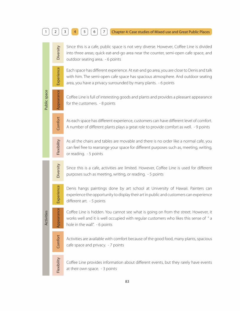
83
Chapter 4: Case studies of Mixed use and Great Public Places 1 2 3 4 5 6 7
Since this is a cafe, public space is not very diverse. However, Coff ee Line is divided
into three areas; quick eat-and-go area near the counter, semi-open cafe space, and
outdoor seating area. - 6 points
Pub
lic s
pac
e
Div
ersi
tyEx
per
ienc
eA
pp
eara
nce
Com
fort
Flex
ibili
ty
Each space has diff erent experience. At eat-and go area, you are close to Denis and talk
with him. The semi-open cafe space has spacious atmosphere. And outdoor seating
area, you have a privacy surrounded by many plants. - 6 points
As each space has diff erent experience, customers can have diff erent level of comfort.
A number of diff erent plants plays a great role to provide comfort as well. - 9 points
As all the chairs and tables are movable and there is no order like a normal cafe, you
can feel free to rearrange your space for diff erent purposes such as, meeting, writing,
or reading. - 5 points
Coff ee Line is full of interesting goods and plants and provides a pleasant appearance
for the customers. - 8 points
Since this is a cafe, activities are limited. However, Coff ee Line is used for diff erent
purposes such as meeting, writing, or reading. - 5 points
Act
iviti
es
Div
ersi
tyEx
per
ienc
eA
pp
eara
nce
Com
fort
Flex
ibili
ty
Denis hangs paintings done by art school at University of Hawaii. Painters can
experience the opportunity to display their art in public and customers can experience
diff erent art. - 5 points
Activities are available with comfort because of the good food, many plants, spacious
cafe space and privacy. - 7 points
Coff ee Line provides information about diff erent events, but they rarely have events
at their own space. - 3 points
Coff ee Line is hidden. You cannot see what is going on from the street. However, it
works well and it is well occupied with regular customers who likes this sense of “ a
hole in the wall”. - 6 points
84
Chapter 4: Case studies of Mixed use and Great Public Places 1 2 3 4 5 6 7
13. What is learned from the case studies
Defi ning an identity for a neighborhood is very conceptual and sometimes vague, but it is more
understandable by evaluating diff erent places using the tools above. The most obvious result from
the evaluation is that fl exibility is hard to achieve, no matter what the factors are. Flexibility is the
key to design a place where an identity can change according to the trend at each period of time.
Another fi nding is that landscape plays a great role in providing comfort and forming an identity in
most cases.
The focus of this project is how to form an identity of the Makiki neighborhood. The case studies
above are certain places and the scale is diff erent from Makiki. However, it is important to see
identities in a small scale and apply that in a neighborhood scale. Moreover, an identity is created
by groups of diff erent places. It is ideal to design a neighborhood that has great places where an
identity can grow over time. The goal is to create a neighborhood that can be evaluated with all-10-
points factors.
85
Chapter 5: Implementation Strategy - Zoning
Zoning
The existing zoning is regulated by the City and County of Honolulu Land Use Ordinance (LUO).
The purpose of LUO is to regulate land use in a manner that will encourage orderly development
in accordance with adopted land use policies, and to promote and protect the public health, safety
and welfare. It is the intention of the council that the provisions of the LUO provide reasonable
development and design standards for the location, height, bulk and size of structures, yard areas,
off -street parking facilities, and open spaces, and the use of structures and land for agriculture,
industry, residences or other purposes. 1
The main focus of this chapter is to analyze the existing zoning and consider if it is appropriate for
a high-density mixed use neighborhood. If it is inappropriate, the analysis of the existing condition
will be followed by proposed condition.
1. Zoning districts
It is necessary to change the existing zoning districts when it does not allow mixed use in a
neighborhood. The next step is to determine which mixed use district is suitable for the neighborhood.
The existing LUO includes the following mixed use types:
• AMX-1 (Apartment mixed use district: Low-density)
• AMX-2 (Apartment mixed use district: Mid-density)
• AMX-3 (Apartment mixed use district: High-density)
• BMX-3 (Business mixed use district: Community)
• BMX-4 (Business mixed use district: Central)
_______________________________
1. Department of Planning and Permitting: Land Use Ordinance, Honolulu, HI, 2003

86
Chapter 5: Implementation Strategy - Zoning 1 2 3 4 5 6 7
Purpose and intent of Apartment mixed use district
The purpose of the apartment mixed use districts is to allow some commercial uses in apartment
neighborhoods. The additional commercial uses shall be permitted under varying intensities and are
intended to support the daily and weekly commercial service needs of the neighborhood, conserve
transportation energy by lessening automobile dependency, create more diverse neighborhoods and
optimize the use of both land and available urban services and facilities. Mixing may occur horizontally
and vertically, but controls are established to maintain the character of these neighborhoods primarily as
apartment neighborhoods. (from Land Use Ordinance, Sec. 21-3.90)
Purpose and intent of Business mixed use district
The purpose of the business mixed use districts is to recognize that certain areas of the city have historically
been mixtures of commercial and residential uses, occurring vertically and horizontally and to encourage
the continuance and strengthening of this pattern. It is the intent to provide residences in very close
proximity to employment and retail opportunities, provide innovative and stimulating living environments
and reduce overall neighborhood energy consumption.
The intent of the BMX-3 community business mixed use district is to provide areas for both commercial and
residential uses outside of the central business mixed use district and at a lower intensity than the central
business mixed use district. Typically, this district would be applied to areas along major thoroughfares
adjacent to B-2, BMX-4, A-3, AMX-2 and AMX-3 zoning districts. It is also intended that it be applied to areas
where the existing land use pattern is already a mixture of commercial and residential uses, occurring
horizontally, vertically or both.
The intent of the BMX-4 central business mixed use district is to set apart that portion of Honolulu which
forms the city’s center for fi nancial, offi ce and governmental activities and housing. It is intended for the
downtown area and not intended for general application. It provides the highest land use intensity for
commerce, business and housing. (from Land Use Ordinance, Sec. 21-3.110)
AMX is suitable for a neighborhood like Makiki
A neighborhood that already has a strong character of residential neighborhood (like Makiki) should
maintain the character by introducing AMX as it is intended to:
• support the daily commercial service needs of the neighborhood
• conserve transportation energy by reducing automobile dependency
• create more diverse neighborhoods
• optimize the use of both land and available urban services and facilities
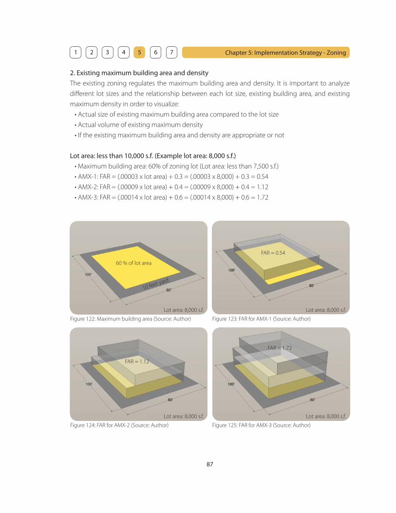
87
Chapter 5: Implementation Strategy - Zoning 1 2 3 4 5 6 7
2. Existing maximum building area and density
The existing zoning regulates the maximum building area and density. It is important to analyze
diff erent lot sizes and the relationship between each lot size, existing building area, and existing
maximum density in order to visualize:
• Actual size of existing maximum building area compared to the lot size
• Actual volume of existing maximum density
• If the existing maximum building area and density are appropriate or not
Lot area: less than 10,000 s.f. (Example lot area: 8,000 s.f.)
• Maximum building area: 60% of zoning lot (Lot area: less than 7,500 s.f.)
• AMX-1: FAR = (.00003 x lot area) + 0.3 = (.00003 x 8,000) + 0.3 = 0.54
• AMX-2: FAR = (.00009 x lot area) + 0.4 = (.00009 x 8,000) + 0.4 = 1.12
• AMX-3: FAR = (.00014 x lot area) + 0.6 = (.00014 x 8,000) + 0.6 = 1.72
Figure 122: Maximum building area (Source: Author)
60 % of lot area
10 feet yard
Lot area: 8,000 s.f. Lot area: 8,000 s.f.
Lot area: 8,000 s.f. Lot area: 8,000 s.f.
Figure 123: FAR for AMX-1 (Source: Author)
Figure 124: FAR for AMX-2 (Source: Author) Figure 125: FAR for AMX-3 (Source: Author)
FAR = 0.54
FAR = 1.12
FAR = 1.72
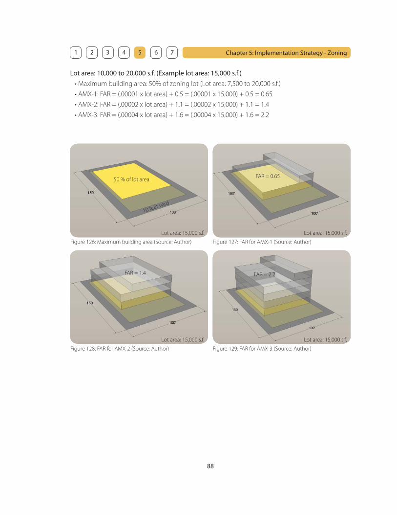
88
Chapter 5: Implementation Strategy - Zoning 1 2 3 4 5 6 7
Figure 126: Maximum building area (Source: Author)
50 % of lot area
10 feet yard
Lot area: 15,000 s.f. Lot area: 15,000 s.f.
Lot area: 15,000 s.f. Lot area: 15,000 s.f.
Figure 127: FAR for AMX-1 (Source: Author)
Figure 128: FAR for AMX-2 (Source: Author) Figure 129: FAR for AMX-3 (Source: Author)
Lot area: 10,000 to 20,000 s.f. (Example lot area: 15,000 s.f.)
• Maximum building area: 50% of zoning lot (Lot area: 7,500 to 20,000 s.f.)
• AMX-1: FAR = (.00001 x lot area) + 0.5 = (.00001 x 15,000) + 0.5 = 0.65
• AMX-2: FAR = (.00002 x lot area) + 1.1 = (.00002 x 15,000) + 1.1 = 1.4
• AMX-3: FAR = (.00004 x lot area) + 1.6 = (.00004 x 15,000) + 1.6 = 2.2
FAR = 0.65
FAR = 1.4 FAR = 2.2
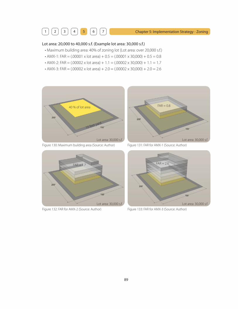
89
Chapter 5: Implementation Strategy - Zoning 1 2 3 4 5 6 7
Figure 130: Maximum building area (Source: Author)
40 % of lot area
10 feet yard
Lot area: 30,000 s.f. Lot area: 30,000 s.f.
Lot area: 30,000 s.f. Lot area: 30,000 s.f.
Figure 131: FAR for AMX-1 (Source: Author)
Figure 132: FAR for AMX-2 (Source: Author) Figure 133: FAR for AMX-3 (Source: Author)
Lot area: 20,000 to 40,000 s.f. (Example lot area: 30,000 s.f.)
• Maximum building area: 40% of zoning lot (Lot area: over 20,000 s.f.)
• AMX-1: FAR = (.00001 x lot area) + 0.5 = (.00001 x 30,000) + 0.5 = 0.8
• AMX-2: FAR = (.00002 x lot area) + 1.1 = (.00002 x 30,000) + 1.1 = 1.7
• AMX-3: FAR = (.00002 x lot area) + 2.0 = (.00002 x 30,000) + 2.0 = 2.6
FAR = 0.8
FAR = 1.7 FAR = 2.6
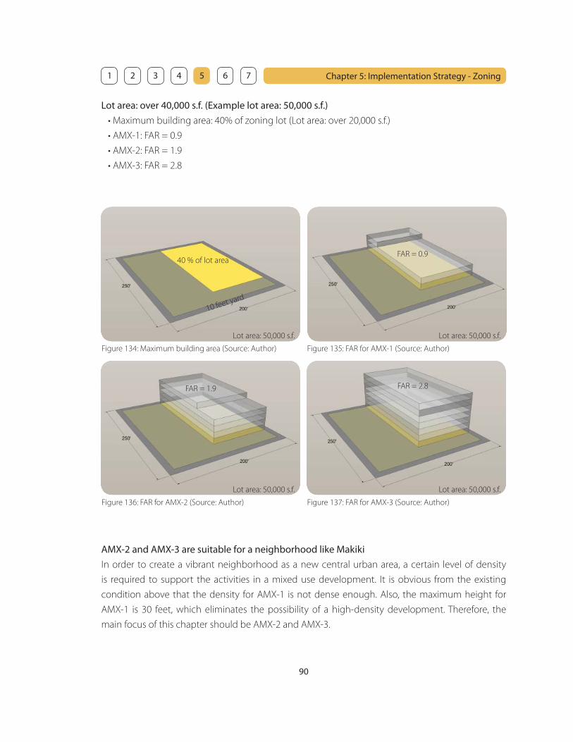
90
Chapter 5: Implementation Strategy - Zoning 1 2 3 4 5 6 7
Figure 134: Maximum building area (Source: Author)
40 % of lot area
10 feet yard
Lot area: 50,000 s.f. Lot area: 50,000 s.f.
Lot area: 50,000 s.f. Lot area: 50,000 s.f.
Figure 135: FAR for AMX-1 (Source: Author)
Figure 136: FAR for AMX-2 (Source: Author) Figure 137: FAR for AMX-3 (Source: Author)
Lot area: over 40,000 s.f. (Example lot area: 50,000 s.f.)
• Maximum building area: 40% of zoning lot (Lot area: over 20,000 s.f.)
• AMX-1: FAR = 0.9
• AMX-2: FAR = 1.9
• AMX-3: FAR = 2.8
FAR = 0.9
FAR = 1.9 FAR = 2.8
AMX-2 and AMX-3 are suitable for a neighborhood like Makiki
In order to create a vibrant neighborhood as a new central urban area, a certain level of density
is required to support the activities in a mixed use development. It is obvious from the existing
condition above that the density for AMX-1 is not dense enough. Also, the maximum height for
AMX-1 is 30 feet, which eliminates the possibility of a high-density development. Therefore, the
main focus of this chapter should be AMX-2 and AMX-3.

91
Chapter 5: Implementation Strategy - Zoning 1 2 3 4 5 6 7
Constraints of existing maximum building area and density
Maximum building area provides an opportunity for open space around the building when the
open space is utilized for people to gather and interact such as plazas or pocket parks. However, the
open spaces could be turned into factors for unattractive streetscape such as parking lot.
Figure 138: Open space used for plaza (Source: Author) Figure 139: Open space usde for parking (Source: Author)
How about the density? Although it was concluded that AMX-1 is not dense enough, it is still hard
to tell from the analysis of existing condition above whether the density is appropriate or not. The
adequacy of density could be measured by the use of the building. The use which takes up a lot
of space is parking. It could be one of the effi cient way to visualize the adequacy of density by
analyzing how parking space governs the building density. The number of parking is determined by
the parking requirement. The next section will focus on the existing parking requirement.
3. Existing parking requirement
Building form is often governed by the parking. It is important to see the relationship and ratio
between the parking and the rest of the building in order to visualize:
• Possibility of the building form
• Density of the building without the parking
• If the existing parking requirement is appropriate or not
The examples below show the maximum parking for the rest of the building. The steps of the
procedure used here are:
1. Provide possible maximum parking for the lot size (shown as orange blocks)
2. Calculate the total fl oor area of other uses except for the parking (shown as gray blocks)
3. Check the existing parking requirement for the total fl oor area in each category
4. Compare the requirement with the possible maximum parking
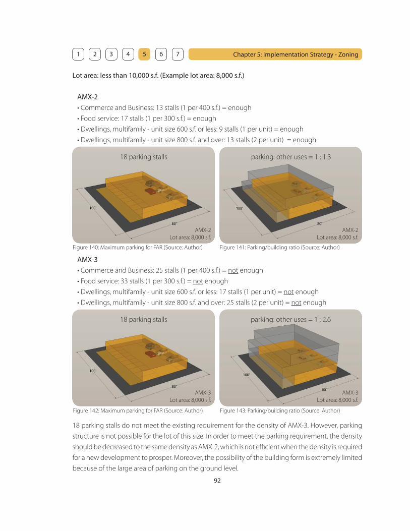
92
Chapter 5: Implementation Strategy - Zoning 1 2 3 4 5 6 7
Lot area: less than 10,000 s.f. (Example lot area: 8,000 s.f.)
AMX-2
• Commerce and Business: 13 stalls (1 per 400 s.f.) = enough
• Food service: 17 stalls (1 per 300 s.f.) = enough
• Dwellings, multifamily - unit size 600 s.f. or less: 9 stalls (1 per unit) = enough
• Dwellings, multifamily - unit size 800 s.f. and over: 13 stalls (2 per unit) = enough
parking: other uses = 1 : 1.3
AMX-2
Lot area: 8,000 s.f.
AMX-2
Lot area: 8,000 s.f.
Figure 140: Maximum parking for FAR (Source: Author) Figure 141: Parking/building ratio (Source: Author)
18 parking stalls
AMX-3
• Commerce and Business: 25 stalls (1 per 400 s.f.) = not enough
• Food service: 33 stalls (1 per 300 s.f.) = not enough
• Dwellings, multifamily - unit size 600 s.f. or less: 17 stalls (1 per unit) = not enough
• Dwellings, multifamily - unit size 800 s.f. and over: 25 stalls (2 per unit) = not enough
18 parking stalls do not meet the existing requirement for the density of AMX-3. However, parking
structure is not possible for the lot of this size. In order to meet the parking requirement, the density
should be decreased to the same density as AMX-2, which is not effi cient when the density is required
for a new development to prosper. Moreover, the possibility of the building form is extremely limited
because of the large area of parking on the ground level.
AMX-3
Lot area: 8,000 s.f.
AMX-3
Lot area: 8,000 s.f.
parking: other uses = 1 : 2.6
Figure 142: Maximum parking for FAR (Source: Author) Figure 143: Parking/building ratio (Source: Author)
18 parking stalls
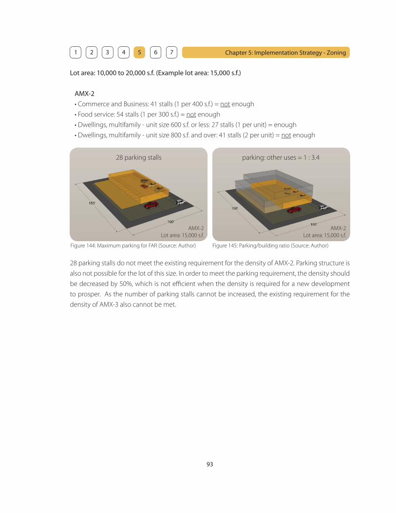
93
Chapter 5: Implementation Strategy - Zoning 1 2 3 4 5 6 7
Lot area: 10,000 to 20,000 s.f. (Example lot area: 15,000 s.f.)
AMX-2
• Commerce and Business: 41 stalls (1 per 400 s.f.) = not enough
• Food service: 54 stalls (1 per 300 s.f.) = not enough
• Dwellings, multifamily - unit size 600 s.f. or less: 27 stalls (1 per unit) = enough
• Dwellings, multifamily - unit size 800 s.f. and over: 41 stalls (2 per unit) = not enough
AMX-2
Lot area: 15,000 s.f.
AMX-2
Lot area: 15,000 s.f.
parking: other uses = 1 : 3.4
Figure 144: Maximum parking for FAR (Source: Author) Figure 145: Parking/building ratio (Source: Author)
28 parking stalls
28 parking stalls do not meet the existing requirement for the density of AMX-2. Parking structure is
also not possible for the lot of this size. In order to meet the parking requirement, the density should
be decreased by 50%, which is not effi cient when the density is required for a new development
to prosper. As the number of parking stalls cannot be increased, the existing requirement for the
density of AMX-3 also cannot be met.
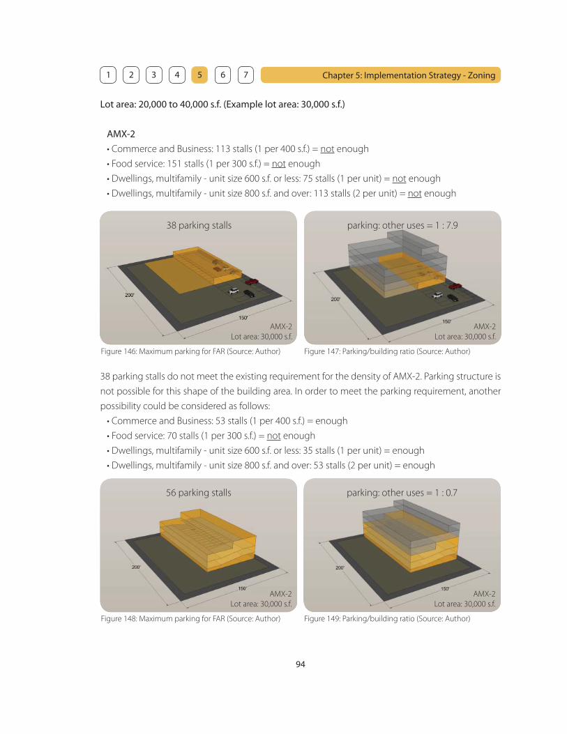
94
Chapter 5: Implementation Strategy - Zoning 1 2 3 4 5 6 7
Lot area: 20,000 to 40,000 s.f. (Example lot area: 30,000 s.f.)
AMX-2
• Commerce and Business: 113 stalls (1 per 400 s.f.) = not enough
• Food service: 151 stalls (1 per 300 s.f.) = not enough
• Dwellings, multifamily - unit size 600 s.f. or less: 75 stalls (1 per unit) = not enough
• Dwellings, multifamily - unit size 800 s.f. and over: 113 stalls (2 per unit) = not enough
AMX-2
Lot area: 30,000 s.f.
AMX-2
Lot area: 30,000 s.f.
parking: other uses = 1 : 7.938 parking stalls
38 parking stalls do not meet the existing requirement for the density of AMX-2. Parking structure is
not possible for this shape of the building area. In order to meet the parking requirement, another
possibility could be considered as follows:
• Commerce and Business: 53 stalls (1 per 400 s.f.) = enough
• Food service: 70 stalls (1 per 300 s.f.) = not enough
• Dwellings, multifamily - unit size 600 s.f. or less: 35 stalls (1 per unit) = enough
• Dwellings, multifamily - unit size 800 s.f. and over: 53 stalls (2 per unit) = enough
Figure 146: Maximum parking for FAR (Source: Author) Figure 147: Parking/building ratio (Source: Author)
AMX-2
Lot area: 30,000 s.f.
AMX-2
Lot area: 30,000 s.f.
parking: other uses = 1 : 0.756 parking stalls
Figure 148: Maximum parking for FAR (Source: Author) Figure 149: Parking/building ratio (Source: Author)

95
Chapter 5: Implementation Strategy - Zoning 1 2 3 4 5 6 7
Although the parking requirements are almost met, the diagrams above show that a parking
structure takes up a lot of space. Compared to the former diagrams, the volume is so much larger,
but the parking is increased only by 13 stalls.
AMX-3
• Commerce and Business: 75 stalls (1 per 400 s.f.) = enough
• Food service: 100 stalls (1 per 300 s.f.) = not enough
• Dwellings, multifamily - unit size 600 s.f. or less: 50 stalls (1 per unit) = enough
• Dwellings, multifamily - unit size 800 s.f. and over: 75 stalls (2 per unit) = enough
AMX-3
Lot area: 30,000 s.f.
AMX-3
Lot area: 30,000 s.f.
parking: other uses = 1 : 0.676 parking stalls
Figure 150: Maximum parking for FAR (Source: Author) Figure 151: Parking/building ratio (Source: Author)
The parking requirements are almost met for AMX-3 as well. However, the volume of the parking
seems to overwhelm the volume of the rest of the building.
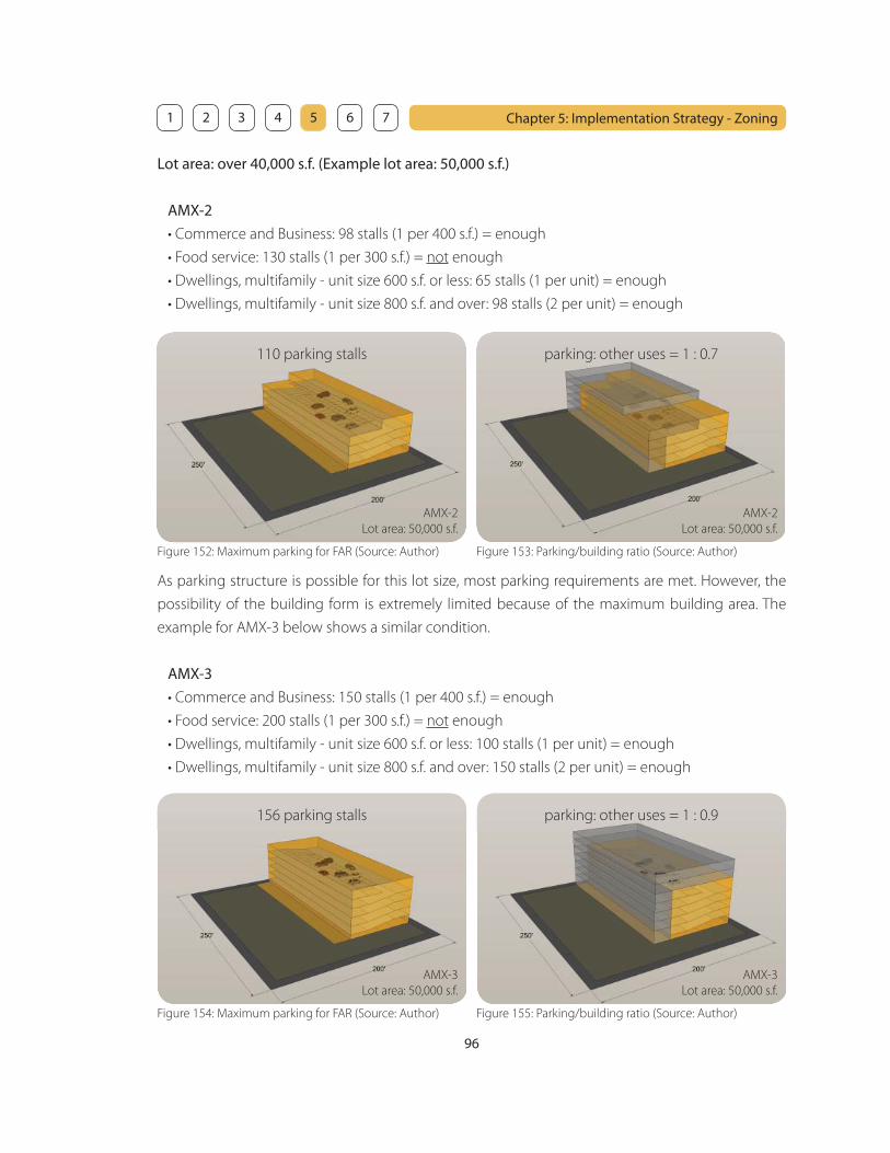
96
Chapter 5: Implementation Strategy - Zoning 1 2 3 4 5 6 7
AMX-2
Lot area: 50,000 s.f.
AMX-2
Lot area: 50,000 s.f.
parking: other uses = 1 : 0.7110 parking stalls
As parking structure is possible for this lot size, most parking requirements are met. However, the
possibility of the building form is extremely limited because of the maximum building area. The
example for AMX-3 below shows a similar condition.
AMX-3
• Commerce and Business: 150 stalls (1 per 400 s.f.) = enough
• Food service: 200 stalls (1 per 300 s.f.) = not enough
• Dwellings, multifamily - unit size 600 s.f. or less: 100 stalls (1 per unit) = enough
• Dwellings, multifamily - unit size 800 s.f. and over: 150 stalls (2 per unit) = enough
Lot area: over 40,000 s.f. (Example lot area: 50,000 s.f.)
AMX-2
• Commerce and Business: 98 stalls (1 per 400 s.f.) = enough
• Food service: 130 stalls (1 per 300 s.f.) = not enough
• Dwellings, multifamily - unit size 600 s.f. or less: 65 stalls (1 per unit) = enough
• Dwellings, multifamily - unit size 800 s.f. and over: 98 stalls (2 per unit) = enough
Figure 152: Maximum parking for FAR (Source: Author) Figure 153: Parking/building ratio (Source: Author)
AMX-3
Lot area: 50,000 s.f.
AMX-3
Lot area: 50,000 s.f.
parking: other uses = 1 : 0.9156 parking stalls
Figure 154: Maximum parking for FAR (Source: Author) Figure 155: Parking/building ratio (Source: Author)
97
Chapter 5: Implementation Strategy - Zoning 1 2 3 4 5 6 7
Constraints of existing parking requirement
According to the analysis above, it seems that the existing parking requirement is not appropriate
for a high-density development as:
• Parking takes up a lot of space
• Large volume of parking does not allow fl exible building forms
• Density of the uses other than parking (gray blocks) seems to be not dense enough
The building form and the density of the uses other than parking are greatly governed by the
parking, as parking takes up a lot of space. The density of the ‘non-parking’ uses should be denser in
order to support the activities in a neighborhood that is transformed into a high-density mixed use
neighborhood. Moreover, the existing parking requirement encourages reliance on the automobile
and discourages the pedestrian oriented environment.
The constraints above could be resolved by:
• Reducing the parking requirement
• Maximizing the building area within the existing yards = increasing density
Parking requirement could be reduced by the new transit system
As the major means of transportation is the automobile in Honolulu, it is natural that the parking
requirement is critical. However, the state is planning to introduce a new transit system. It is a great
opportunity for a neighborhood that could be a new central urban area to become a pedestrian
oriented neighborhood. As the dependency on the automobile could be reduced by using the
transit system and the secondary feeder system from the transit stations, the parking requirement
could be also reduced. A new central urban area should be a place where people can go anywhere
without using the automobile. The existing common sense that everyone has to have a car should
be changed in order to support the high-density mixed use neighborhood that can accommodate
the growing population.
Maximizing the building area
As stated in section 2, the existing maximum building area provides an opportunity for open space
around the building when the open space is utilized for people to gather and interact such as plazas
or pocket parks. However, the open spaces could be turned into factors for unattractive streetscape
such as parking lot. Although the open space is utilized as plazas or pocket parks, the density and the
fl exibility of building forms are extremely limited. In order to increase the density and the fl exibility
of building forms, the building area should be maximized. Existing yards should be maintained in
order to provide adequate width of the sidewalk and the space between buildings. The example
below shows how the building could be utilized by maximizing the building area.

98
Chapter 5: Implementation Strategy - Zoning 1 2 3 4 5 6 7
AMX-3
Lot area: 50,000 s.f.
Figure 158: Existing condition (Source: Author) Figure 159: Proposed condition (Source: Author)
AMX-3
Lot area: 50,000 s.f.
AMX-3
Lot area: 8,000 s.f.
AMX-3
Lot area: 8,000 s.f.
Figure 156: Existing condition (Source: Author) Figure 157: Proposed condition (Source: Author)
Existing condition
• 18 parking stalls
• parking : other uses = 1 : 2.6
• not dense enough
• not fl exible
Proposed condition
• 0 parking stalls
• 100% other uses
• increase density of other uses
• allow fl exibility
• use shared parking in other buildings
Existing condition
• 156 parking stalls
• parking : other uses = 1 : 0.9
• not dense enough
• not fl exible
Proposed condition
• 233 parking stalls (77 more stalls)
• parking : other uses = 1 : 1.2 (30% gain)
• increase density of other uses
• allow fl exibility
• parking could be shared with other buildings

99
Chapter 5: Implementation Strategy - Zoning 1 2 3 4 5 6 7
The problem of the proposed condition above is a lack of open space. In order to achieve the open
space, height regulation and setback could be utilized. In fact, the density and the height regulation
are closely related. The next section will focus on the height regulation and setback in relation to
the density.
4. Height regulation and setback
The maximum height is regulated according to zoning maps. The existing height regulation does
not allow fl exibility for a new high-density development. It shall be changed according to the open
space provided in order to:
• provide more open space
• allow unique facade and building forms
• increase density
The examples below show the possibilities of open space and increased density. When the open
space is provided, the density shall be increased twice as much as the volume used for open space.
The maximum height shall be changed according to the increased density. This method kills two
birds with one stone as:
• It encourages to provide open space
• The more open space, the more density
Example 1: Maximum height = 40 feet
• Maximum building area = 4,800 s.f.
• Open space = 400 s.f.
• Total fl oor area used for open space provided = 1,600 s.f.
• Actual building area = maximum building area - open space = 4,400 s.f.
• Density could be increased up to 1,600 s.f. x 2 = 3,200 s.f.
• 3,200 s.f. (increased density) < 4,400 s.f. (actual building area) x 1 (1 story)
• Maximum height could be increased by 10 feet (1 story)
Figure 160: Possible open space (Source: Author) Figure 161: Increased density (Source: Author)
AMX-3
Lot area: 8,000 s.f.
AMX-3
Lot area: 8,000 s.f.
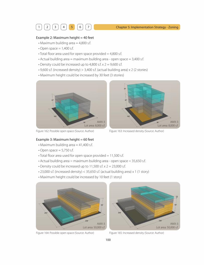
100
Chapter 5: Implementation Strategy - Zoning 1 2 3 4 5 6 7
Figure 162: Possible open space (Source: Author) Figure 163: Increased density (Source: Author)
Example 2: Maximum height = 40 feet
• Maximum building area = 4,800 s.f.
• Open space = 1,400 s.f.
• Total fl oor area used for open space provided = 4,800 s.f.
• Actual building area = maximum building area - open space = 3,400 s.f.
• Density could be increased up to 4,800 s.f. x 2 = 9,600 s.f.
• 9,600 s.f. (increased density) > 3,400 s.f. (actual building area) x 2 (2 stories)
• Maximum height could be increased by 30 feet (3 stories)
AMX-3
Lot area: 8,000 s.f.
AMX-3
Lot area: 8,000 s.f.
Figure 164: Possible open space (Source: Author) Figure 165: Increased density (Source: Author)
Example 3: Maximum height = 60 feet
• Maximum building area = 41,400 s.f.
• Open space = 5,750 s.f.
• Total fl oor area used for open space provided = 11,500 s.f.
• Actual building area = maximum building area - open space = 35,650 s.f.
• Density could be increased up to 11,500 s.f. x 2 = 23,000 s.f.
• 23,000 s.f. (increased density) < 35,650 s.f. (actual building area) x 1 (1 story)
• Maximum height could be increased by 10 feet (1 story)
AMX-3
Lot area: 50,000 s.f.
AMX-3
Lot area: 50,000 s.f.

101
Chapter 5: Implementation Strategy - Zoning 1 2 3 4 5 6 7
Figure 166: Possible open space (Source: Author) Figure 167: Increased density (Source: Author)
Example 4: Maximum height = 60 feet
• Maximum building area = 41,400 s.f.
• Open space = 11,500 s.f.
• Total fl oor area used for open space provided = 23,000 s.f.
• Actual building area = maximum building area - open space = 29,900 s.f.
• Density could be increased up to 23,000 s.f. x 2 = 46,000 s.f.
• 46,000 s.f. (increased density) > 29,000 s.f. (actual building area) x 1 (1 story)
• Maximum height could be increased by 20 feet (2 stories)
AMX-3
Lot area: 50,000 s.f.
AMX-3
Lot area: 50,000 s.f.
Height setback
Height setback of the building facade facing a main street shall be greater in order to:
• reduce the pressure of the building volume on the pedestrian friendly sidewalk
• achieve privacy for the residents above
• enhance more natural lighting
• provide roof top gardens
The diagrams below show existing height setback.
Figure 168: Existing height setback for AMX (Source: LUO)
maximum height shown on zoning maps
grade
property line
10’ required yard
40
’
10
1
slop
e
Figure 169: Example of building form (Source: Author)

102
Chapter 5: Implementation Strategy - Zoning 1 2 3 4 5 6 7
The existing height setback does not allow to reduce the pressure, achieve privacy, enhance lighting,
or provide roof top gardens. Maximum height shall be increased according to the height setback
provided. When the certain amount density is used to provide height setback, the same amount of
density shall be added. The setback should occur along the main street and provide at least 40% of
the top surface area of the largest building volume.
Figure 170: Without height setback (Source: Author)
AMX-3
Lot area: 50,000 s.f.
Figure 171: Proposed height setback (Source: Author)
AMX-3
Lot area: 50,000 s.f.

103
Chapter 6: Implementation Strategy - Design Guideline
Design Guideline
The design guideline is proposed as a methodology to create places where identity can evolve
in Makiki as well as any neighborhood in Honolulu. The guideline is developed based on the
following:
• Demographics - chapter 2
• Site analysis - chapter 2
• Analysis of mixed use - chapter 3
• Three important factors (culture, public space and activities) - chapter 4
• Five basic elements (diversity, experience, appearance, comfort, and fl exibility) - chapter 4
The design guideline addresses aesthetic issues that the neighborhood face in planning mixed
use development. The purpose of the design guideline is to provide ideas, stimulate thinking and
promote good design for a neighborhood. It is intended to:
• improve the quality of functional and physical alterations to the neighborhood
• improve the quality of the pedestrian experience
• create an opportunity for evolving identity (not applied identity)
• promote community awareness of the physical environment
• encourage fl exible and individual creativity rather than homogeneous uniformity

104
Chapter 6: Implementation Strategy - Design Guideline 1 2 3 4 5 6 7
Diff erent uses can be placed in the same development site, the same street block or in close vicinity,
thus the various uses may create convenience and interaction and share infrastructure. The diff erent
uses inculde:
• Residential
• Retail
• Offi ce
• Entertainment
• Community services
Functional and physical integration of uses is important in mixed-use developments. It is a key to
leveraging the advantages of a shared location and customer base. In order to integrate uses, all
project components need to be interconnected by an elaborated pedestrian network. It is also
important to locate key components that have a high demand around activity nodes.
1. Introducing mixed use
Introducing mixed use is a primary strategy that provides an infrastructure to form an identity in a
neighborhood. As I discussed in chapter 3, there are diff erent types of mixed use such as:
• Vertical mixed use
• Town center planned mixed use
• Adaptive mixed use
• Corridor high-density residential mixed use
• Neighborhood mixed use
As each neighborhood is diff erent in size, density, need, or people, it is recommended to introduce
a suitable type of mixed use for the neighborhood.
Figure 172: Diff erent types of mixed use (Source: Author)
Figure 173: Diff erent uses (Source: Web - Flickr)

105
Chapter 6: Implementation Strategy - Design Guideline 1 2 3 4 5 6 7
2. Introducing secondary transit feeder system
In order to bring people to a neighborhood, it is encouraged to introduce a secondary transit feeder
system from a major transit station or places that accommodate a number of people such as a
shopping center or university. It is an important connection between the neighborhood and other
central areas in order to avoid isolation and to bring more people to the neighborhood to support
the business and activities in the mixed use development.
Secondary feeder systems include:
• Streetcar
• Trolley
• Bus
The secondary feeder system allows residents within the neighborhood to walk to a close destination
without using their cars. It contributes to the reduction of reliance on the automobile and fosters a
pedestrian friendly community.
The major means of transportation to work in Honolulu is the automobile. If the secondary feeder
system is utilized effi ciently, residents can use it to go to work. When residents can go to anywhere
without their cars, the needs of the automobile could be drastically reduced, thus the parking
requirements also could be reduced.
The secondary feeder system shall run every 5 minutes in order to achieve convenience and stops
shall be located every 2 blocks within a walking distance. It is also encouraged to have a dedicated
lane for secondary feeder systems in order for them to run effi ciently.
dedicatedlane
dedicatedlane
regularlane
regularlane
Figure 175: Dedicated lanes for secondary feeder systems (Source: Author)
Figure 174: Secondary feeder system (Source: Web - Flickr)

106
Chapter 6: Implementation Strategy - Design Guideline 1 2 3 4 5 6 7
3. Parcel consolidation
Building forms are often governed by the parcel size and confi guration and zoning. Many buildings
in a neighborhood in Honolulu, including Makiki, are developed on the street’s original narrow parcel
confi gurations and zoning. These narrow lots have caused their structures to be oriented sideways,
often yielding a blank wall to the street and giving their openings that face away from the sidewalk
and street in front of their homes. Parcel consolidation enable buildings to have wider facades and
openings that create a pedestrian friendly environment.
Figure 176: Buildings oriented sideways caused by
narrow parcels (Source: Author)
Figure 177: Wider facade and openings achieved by
parcel consolidation (Source: Author)
Parcel consolidation should be encouraged, as it provides:
• opportunity of maximum utilization and good planning for a mixed use development
• wider facades and openings to create a pedestrian friendly environment
• higher profi t return on the property
• alternative building confi gurations, mixing of building types, and spatial use
• opportunity to have public spaces
Parcel consolidation would encourage alternative building confi gurations, the mixing of building
types, and spatial use that are signifi cantly important in creating variety and vitality in a walkable
neighborhood. Buildings could be organized parallel to the street, or in layered confi gurations, or
any mixture of layouts instead of being organized all perpendicular to the street block after block
in narrow parcels. It also encourages to have public space at varying scales such as pocket parks,
plazas, and courtyards. Parcel consolidation may even lend itself favorably to the inclusion of service
alleyways, which could be solutions for internal parking system or better waste management so that
unsightly trash is no longer piled up along the street.
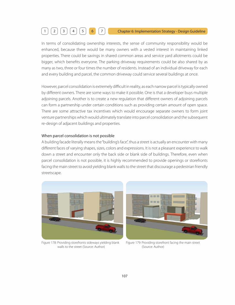
107
Chapter 6: Implementation Strategy - Design Guideline 1 2 3 4 5 6 7
In terms of consolidating ownership interests, the sense of community responsibility would be
enhanced, because there would be many owners with a vested interest in maintaining linked
properties. There could be savings in shared common areas and service yard allotments could be
bigger, which benefi ts everyone. The parking driveway requirements could be also shared by as
many as two, three or four times the number of residents. Instead of an individual driveway for each
and every building and parcel, the common driveway could service several buildings at once.
However, parcel consolidation is extremely diffi cult in reality, as each narrow parcel is typically owned
by diff erent owners. There are some ways to make it possible. One is that a developer buys multiple
adjoining parcels. Another is to create a new regulation that diff erent owners of adjoining parcels
can form a partnership under certain conditions such as providing certain amount of open space.
There are some attractive tax incentives which would encourage separate owners to form joint
venture partnerships which would ultimately translate into parcel consolidation and the subsequent
re-design of adjacent buildings and properties.
When parcel consolidation is not possible
A building facade literally means the “building’s face”, thus a street is actually an encounter with many
diff erent faces of varying shapes, sizes, colors and expressions. It is not a pleasant experience to walk
down a street and encounter only the back side or blank side of buildings. Therefore, even when
parcel consolidation is not possible, it is highly recommended to provide openings or storefronts
facing the main street to avoid yielding blank walls to the street that discourage a pedestrian friendly
streetscape.
Figure 178: Providing storefronts sideways yielding blank
walls to the street (Source: Author)
Figure 179: Providing storefront facing the main street
(Source: Author)

108
Chapter 6: Implementation Strategy - Design Guideline 1 2 3 4 5 6 7
4. Parking
The availability and cost of parking are important factors for people when they make choices about
where to live, work, shop, or conduct business. The challenge is to :
• provide enough parking to meet mobility and economic needs without providing too much
• encourage people to use other ways of travel
• minimize the impacts of parking on the neighborhood character
Amount and Location
The goal for a neighborhood is to have the right amount of parking. This can be very diffi cult for a
community to defi ne because diff erent people have diff erent needs. Residents need a place to park
their cars close to their homes. Businesses need parking spaces for their employees and customers.
Businesses also need inexpensive and accessible parking for customers. Employees and customers
both want to park as close as possible to their destinations. Residents don’t want strangers parking
on their streets, especially when their own parking options are limited. 1
The amount and location of parking should be appropriate for the activities in the neighborhood
without detracting from neighborhood character. Parking can be distributed in an area to encourage
people to walk, use transit, and increase their interactions. It is also important to place all off -street
parking behind the primary uses away from streets or behind landscaped open space in order to
enhance the pedestrian friendly environment.
_______________________________
1. Seattle Department of Transportation: The Parking Tool, Seattle, WA, 1996
Figure 180: Place parking behind the primary uses
(Source: Author)
Figure 181: Place parking behind landscaped open space
(Source: Author)
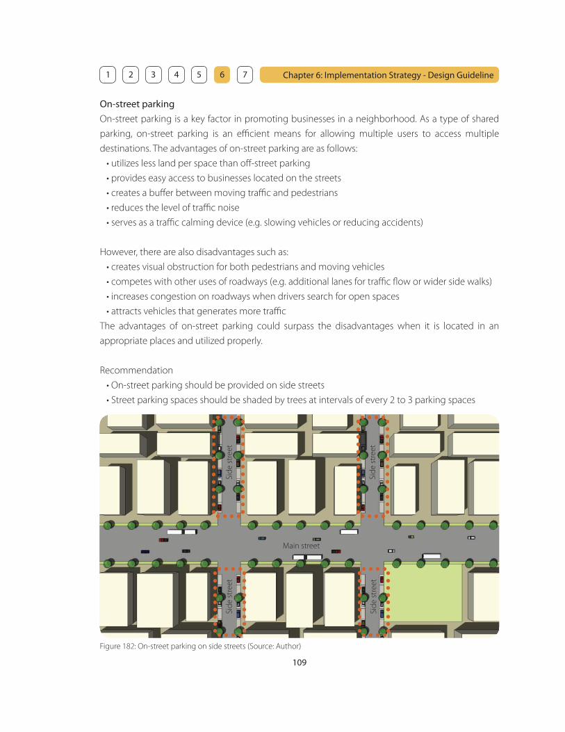
109
Chapter 6: Implementation Strategy - Design Guideline 1 2 3 4 5 6 7
On-street parking
On-street parking is a key factor in promoting businesses in a neighborhood. As a type of shared
parking, on-street parking is an effi cient means for allowing multiple users to access multiple
destinations. The advantages of on-street parking are as follows:
• utilizes less land per space than off -street parking
• provides easy access to businesses located on the streets
• creates a buff er between moving traffi c and pedestrians
• reduces the level of traffi c noise
• serves as a traffi c calming device (e.g. slowing vehicles or reducing accidents)
However, there are also disadvantages such as:
• creates visual obstruction for both pedestrians and moving vehicles
• competes with other uses of roadways (e.g. additional lanes for traffi c fl ow or wider side walks)
• increases congestion on roadways when drivers search for open spaces
• attracts vehicles that generates more traffi c
The advantages of on-street parking could surpass the disadvantages when it is located in an
appropriate places and utilized properly.
Recommendation
• On-street parking should be provided on side streets
• Street parking spaces should be shaded by trees at intervals of every 2 to 3 parking spaces
Figure 182: On-street parking on side streets (Source: Author)
Main street
Sid
e s
tre
et
Sid
e s
tre
et
Sid
e s
tre
et
Sid
e s
tre
et

110
Chapter 6: Implementation Strategy - Design Guideline 1 2 3 4 5 6 7
Off -street parking
According to the City and County of Honolulu Land Use Ordinance, off -street parking is intended
to minimize street congestion and traffi c hazards, and to provide safe and convenient access to
residences, businesses, and public services, but not intended to satisfy maximum parking demand.
However, off -street parking requirements seem to emphasize quantity over quality and overwhelm
the physical landscape with an excessive supply of unattractive parking. However, as stated in
Chapter 5, the required parking should be reduced. It is possible when the secondary transit feeder
system is utilized and the residents’ dependency on the automobile is reduced. Moreover, reduction
of the dependency on the automobile creates a pedestrian oriented environment.
The pedestrian oriented environment is fostered when:
• All off -street parking is placed behind the primary uses away from streets
• Parking access is placed on side streets
• Additional parking structures are located at each end of active main street
• Additional parking structures are placed behind the other uses or landscaped open space
Figure 183: Off -street parking and circulations (Source: Author)
Active main street
Additional
parking
Additional
parking
Automobile circulation
Pedestrian circulation

111
Chapter 6: Implementation Strategy - Design Guideline 1 2 3 4 5 6 7
Figure 184: Cultural diversity (Source: Author and Web - Flickr)
5. Cultural Diversity
The neighborhood shall have a cultural diversity and be a place where people from various cultural
backgrounds can live, work, visit, and enjoy their everyday life.
Cultural events and street markets
The neighborhood shall provide opportunities for various cultural events and street markets. Cultural
events allow people to interact and create an vibrant community. A farmers market provides a
variety of goods and foods from diff erent cultures. These are important for the residents and visitors
to experience a variety of culture in the neighborhood.
Bon Dance - Japanese Dragon Dance - Chinese Hula - Hawaiian
Fan Dance - Korean Mochi Pounding - JapanesePumpkin Carving - Western
Figure 185: Cultural events (Source: Web - Flickr)

112
Chapter 6: Implementation Strategy - Design Guideline 1 2 3 4 5 6 7
Figure 186: Farmers market (Source: Web - Flickr)
London, England
Fort Pierce, FL Des Moines, IA Little Rock, AR
City Park, UT Honolulu, HI
Public space that fosters cultural diversity
Cultural events and street markets provide a diversity of cultural experience such as art, music,
history, food and goods. In order to have various cultural events and activities, the neighborhood
shall provide diff erent types of public space such as:
• Park
• Plaza
• Courtyard
• Wide sidewalk
It is important to start by truly understanding how people will use a place and what activities will
draw them there. Design cannot be the starting point for creating a great public space. Within any
successful public space, there should be several dynamic destinations that attract diff erent kinds
of people. These destinations should off er many things to do, such as gathering, socializing, eating,
reading, playing games, interacting with art, and so on. Creating a great public space requires an
articulated vision of the community for these activities and destinations. Therefore, it is important
to pay attention to the cultural background of the neighborhood. This fi rst step of place-making
process for uses, activities, and destinations leads to detail design that will succeed.
Figure 187: Public space (Source: Author and Web - Flickr)

113
Chapter 6: Implementation Strategy - Design Guideline 1 2 3 4 5 6 7
Residential Residential
Residential Residential
Mixed useMixed use
Mixed useMixed use
Park Park
Park Park
Figure 188: Park (Source: Author) Figure 189: Plaza (Source: Author)
Figure 190: Courtyard (Source: Author) Figure 191: Wide sidewalk (Source: Author)
Parks have an ability to accommodate many diff erent types of uses and people. They could be the
places where you might meet a friend for lunch, stage an outdoor concert for a large number of
people, or just relax and read a book. Parks can act as a buff er between residential area and high-
dense mixed use area. Diff erent types of public space provide various kind of activity nodes and
pedestrian networks between those nodes.
Activity nodes Pedestrian network
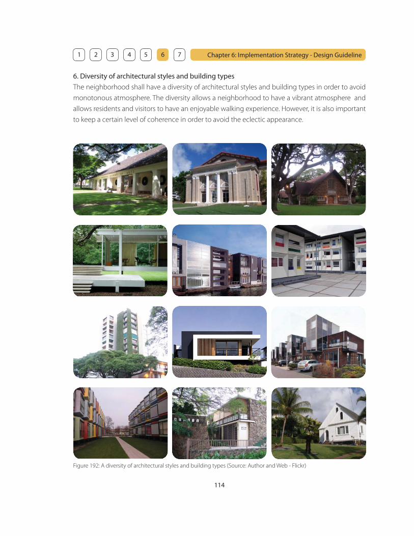
114
Chapter 6: Implementation Strategy - Design Guideline 1 2 3 4 5 6 7
6. Diversity of architectural styles and building types
The neighborhood shall have a diversity of architectural styles and building types in order to avoid
monotonous atmosphere. The diversity allows a neighborhood to have a vibrant atmosphere and
allows residents and visitors to have an enjoyable walking experience. However, it is also important
to keep a certain level of coherence in order to avoid the eclectic appearance.
Figure 192: A diversity of architectural styles and building types (Source: Author and Web - Flickr)

115
Chapter 6: Implementation Strategy - Design Guideline 1 2 3 4 5 6 7
Diversity of architectural styles
In order to create a neighborhood as a new central urban area, it is encouraged to introduce a
modern style that is incorporated with the sense of cultural diversity. It should be encouraged to
refl ect the local, micro-cultural conditions in the neighborhood. However, designers and developers
of new buildings and developments should not reference the specifi c cultural elements, as the
cultural distribution may change overtime. For example, it is not eff ective to create Japanese style
houses just because the dominant cultural background in a neighborhood is Japanese. Trends
change. It is important to design buildings that are fl exible and timeless.
It is extremely diffi cult to control the architectural style and design, as buildings are designed by
diff erent designers and developers and it is hard to defi ne what is good design and what is not.
The awareness of good design must begin with the designers, clients, owners, and developers. It is
important to get them aware of what kind of design language is possible. The best way would be to
fi nd one developer and one good designer, and create one or two really noticeable buildings in the
area. This would set a precedent for the area, and others would follow the example. There may be a
lot of details such as colors, materials, textures, or shapes that will support the big idea, and they all
work together, in synergy, to create a heightened awareness and desire for good design.
Diversity of building types
Diversity in building type should include mixed uses within the diff erent building types. For example,
the combination of residential and retail uses within the same building should be encouraged. The
diversity of building types includes:
• Historical buildings
• Single family houses
• Low-rise buildings
• Mid-rise buildings
• High-rise buildings
Historical buildings shall be preserved for residents and visitors to experience the historical and
cultural richness of a neighborhood. They provide educational opportunity for residents and visitors
to discover the culture and history in the neighborhood.
Figure 193: Diversity of building types (Source: Author and Web - Flickr)

116
Chapter 6: Implementation Strategy - Design Guideline 1 2 3 4 5 6 7
7. Landscape
Landscape plays an important role in order to create a pleasant environment in a neighborhood.
Trees, shrubs and groundcovers are vital elements in the fabric of a neighborhood, as they:
• create connection between people and nature
• foster cultural awareness
• soften hard urban surfaces
• provide a physical buff er between the pedestrian and vehicular traffi c
The urban landscape can be treated in a geometric or a soft, organic manner. Plant materials can
be used formally to create a rigid and artifi cial design or casually to create a curvilinear and natural
design. Either design strategy may be introduced in order to provide a pleasant neighborhood’s
urban experience and its sense of place.
Figure 194: Rigid and artifi cial landscape design
(Source: Book - Contemporary Landscape)
Figure 195: Curvilinear and natural landscape design
(Source: WKM Landscape Architects - Image library)
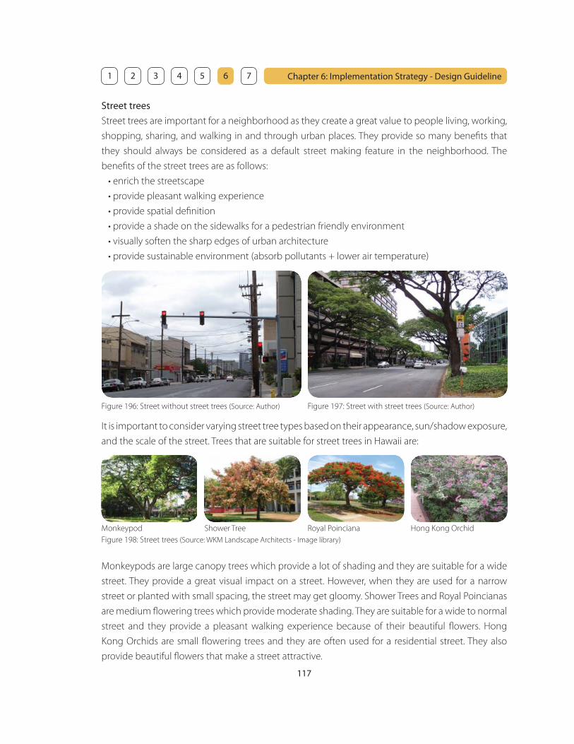
117
Chapter 6: Implementation Strategy - Design Guideline 1 2 3 4 5 6 7
Street trees
Street trees are important for a neighborhood as they create a great value to people living, working,
shopping, sharing, and walking in and through urban places. They provide so many benefi ts that
they should always be considered as a default street making feature in the neighborhood. The
benefi ts of the street trees are as follows:
• enrich the streetscape
• provide pleasant walking experience
• provide spatial defi nition
• provide a shade on the sidewalks for a pedestrian friendly environment
• visually soften the sharp edges of urban architecture
• provide sustainable environment (absorb pollutants + lower air temperature)
Figure 196: Street without street trees (Source: Author) Figure 197: Street with street trees (Source: Author)
It is important to consider varying street tree types based on their appearance, sun/shadow exposure,
and the scale of the street. Trees that are suitable for street trees in Hawaii are:
Shower Tree Hong Kong OrchidRoyal PoincianaMonkeypod
Figure 198: Street trees (Source: WKM Landscape Architects - Image library)
Monkeypods are large canopy trees which provide a lot of shading and they are suitable for a wide
street. They provide a great visual impact on a street. However, when they are used for a narrow
street or planted with small spacing, the street may get gloomy. Shower Trees and Royal Poincianas
are medium fl owering trees which provide moderate shading. They are suitable for a wide to normal
street and they provide a pleasant walking experience because of their beautiful fl owers. Hong
Kong Orchids are small fl owering trees and they are often used for a residential street. They also
provide beautiful fl owers that make a street attractive.
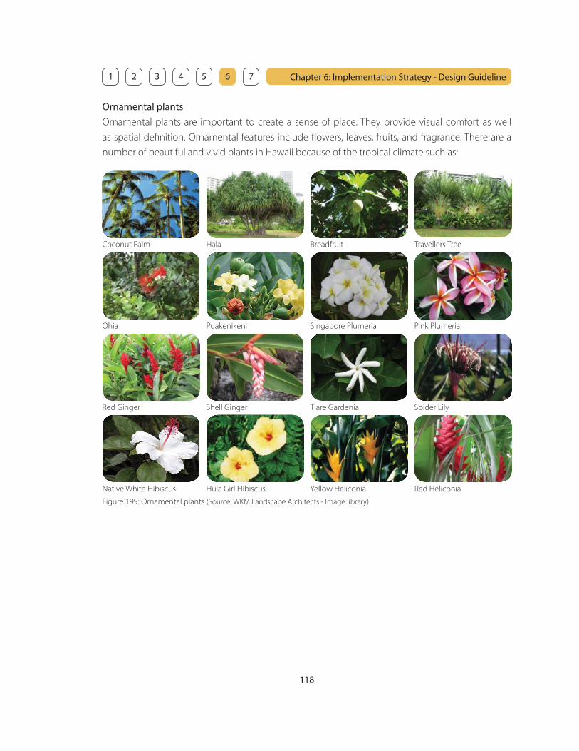
118
Chapter 6: Implementation Strategy - Design Guideline 1 2 3 4 5 6 7
Ornamental plants
Ornamental plants are important to create a sense of place. They provide visual comfort as well
as spatial defi nition. Ornamental features include fl owers, leaves, fruits, and fragrance. There are a
number of beautiful and vivid plants in Hawaii because of the tropical climate such as:
Coconut Palm Hala Breadfruit
Singapore Plumeria
Red Ginger Shell Ginger Tiare Gardenia Spider Lily
Native White Hibiscus Hula Girl Hibiscus Yellow Heliconia Red Heliconia
Ohia Pink Plumeria
Travellers Tree
Puakenikeni
Figure 199: Ornamental plants (Source: WKM Landscape Architects - Image library)
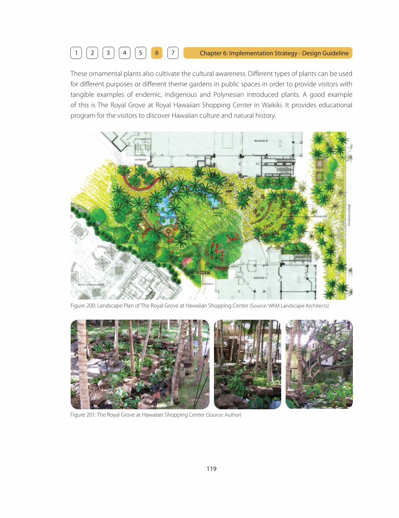
119
Chapter 6: Implementation Strategy - Design Guideline 1 2 3 4 5 6 7
These ornamental plants also cultivate the cultural awareness. Diff erent types of plants can be used
for diff erent purposes or diff erent theme gardens in public spaces in order to provide visitors with
tangible examples of endemic, indigenous and Polynesian introduced plants. A good example
of this is The Royal Grove at Royal Hawaiian Shopping Center in Waikiki. It provides educational
program for the visitors to discover Hawaiian culture and natural history.
Figure 200: Landscape Plan of The Royal Grove at Hawaiian Shopping Center (Source: WKM Landscape Architects)
Figure 201: The Royal Grove at Hawaiian Shopping Center (Source: Author)

120
Chapter 6: Implementation Strategy - Design Guideline 1 2 3 4 5 6 7
Groundcovers
Groundcovers are low-growing plants that spread quickly to form a dense cover. They add beauty to
the landscape and, at the same time, help prevent soil erosion. Groundcovers can be used for many
purposes, as they:
• provide layers and depth to the landscape design in addition to trees and shrubs
• change the spatial defi nition of the streetscape
• provide privacy for outdoor dining areas
• act as a buff er for pedestrians along high-volume traffi c ways
• restrict pedestrians from crossing areas where the original intention was not for crossing
Grass is the best known groundcover, but grass is not always suitable for all locations. Grass is often
used for relatively large areas where people would gather for physical activities or just relaxing such
as parks or multi purpose outdoor area. Other groundcovers should be used for places for diff erent
purposes such as spatial defi nition, providing privacy, or a buff er. The groundcovers other than grass
that are often used in Hawaii are:
Naupaka Pohinahina Laua’e Fern Kupukupu Fern
Figure 204: Groundcovers (Source: WKM Landscape Architects - Image library)
Figure 202: Groundcovers acting as a buff er (Source: Author) Figure 203: Groundcovers providing privacy (Source: Author)
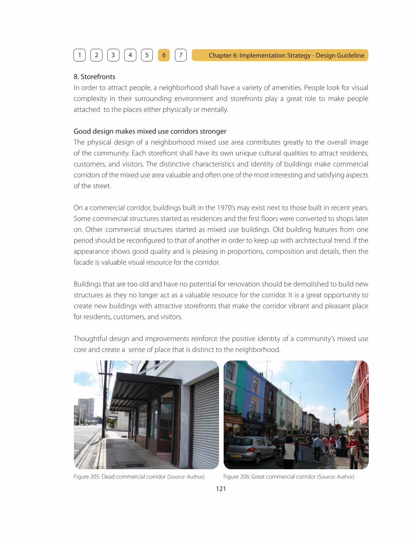
121
Chapter 6: Implementation Strategy - Design Guideline 1 2 3 4 5 6 7
8. Storefronts
In order to attract people, a neighborhood shall have a variety of amenities. People look for visual
complexity in their surrounding environment and storefronts play a great role to make people
attached to the places either physically or mentally.
Good design makes mixed use corridors stronger
The physical design of a neighborhood mixed use area contributes greatly to the overall image
of the community. Each storefront shall have its own unique cultural qualities to attract residents,
customers, and visitors. The distinctive characteristics and identity of buildings make commercial
corridors of the mixed use area valuable and often one of the most interesting and satisfying aspects
of the street.
On a commercial corridor, buildings built in the 1970’s may exist next to those built in recent years.
Some commercial structures started as residences and the fi rst fl oors were converted to shops later
on. Other commercial structures started as mixed use buildings. Old building features from one
period should be reconfi gured to that of another in order to keep up with architectural trend. If the
appearance shows good quality and is pleasing in proportions, composition and details, then the
facade is valuable visual resource for the corridor.
Buildings that are too old and have no potential for renovation should be demolished to build new
structures as they no longer act as a valuable resource for the corridor. It is a great opportunity to
create new buildings with attractive storefronts that make the corridor vibrant and pleasant place
for residents, customers, and visitors.
Thoughtful design and improvements reinforce the positive identity of a community’s mixed use
core and create a sense of place that is distinct to the neighborhood.
Figure 206: Great commercial corridor (Source: Author)Figure 205: Dead commercial corridor (Source: Author)
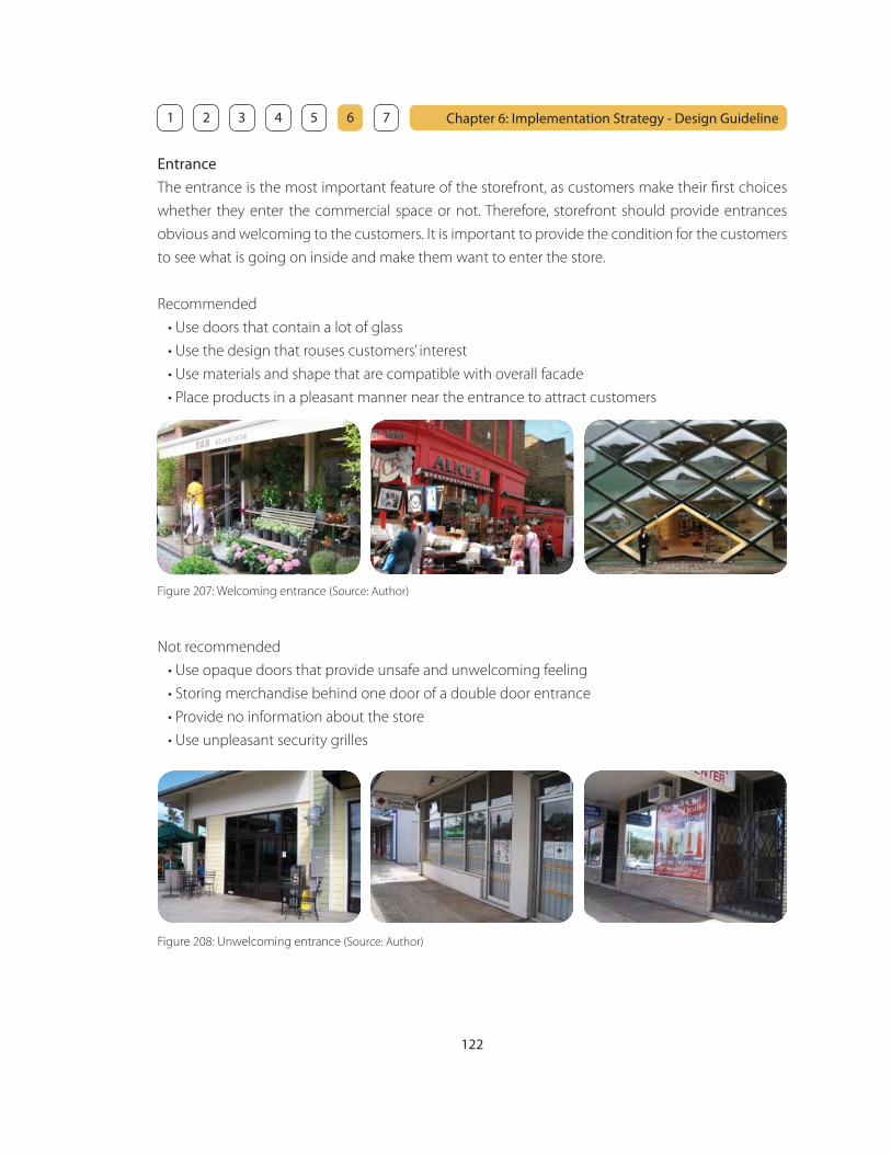
122
Chapter 6: Implementation Strategy - Design Guideline 1 2 3 4 5 6 7
Entrance
The entrance is the most important feature of the storefront, as customers make their fi rst choices
whether they enter the commercial space or not. Therefore, storefront should provide entrances
obvious and welcoming to the customers. It is important to provide the condition for the customers
to see what is going on inside and make them want to enter the store.
Recommended
• Use doors that contain a lot of glass
• Use the design that rouses customers’ interest
• Use materials and shape that are compatible with overall facade
• Place products in a pleasant manner near the entrance to attract customers
Figure 207: Welcoming entrance (Source: Author)
Figure 208: Unwelcoming entrance (Source: Author)
Not recommended
• Use opaque doors that provide unsafe and unwelcoming feeling
• Storing merchandise behind one door of a double door entrance
• Provide no information about the store
• Use unpleasant security grilles

123
Chapter 6: Implementation Strategy - Design Guideline 1 2 3 4 5 6 7
Windows and display
Windows play an important role for the store, as they provide opportunities to display their products
and attract customers. A display should draw attention to the products or services within the store.
Recommended
• Use large windows to provide the maximum amount of visibility
• Use clear glass for easy viewing into the store
• Keep the glass clean
• Use the full extent of the window to display products
• Make the display exciting, fun, and unique
Not Recommended
• Provide blank walls instead of windows
• Use tinted, opaque or smoked glass
• Cover windows with too much signage
• Attach paper signs on windows
• Clutter window displays with too much merchandise
• Use window display as storage
• Keep display windows empty
Figure 209: Attractive windows and display (Source: Author and Web - Flickr)
Figure 210: Unattractive windows and display (Source: Author)
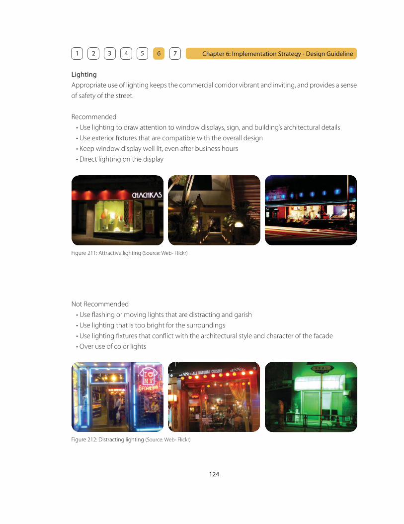
124
Chapter 6: Implementation Strategy - Design Guideline 1 2 3 4 5 6 7
Lighting
Appropriate use of lighting keeps the commercial corridor vibrant and inviting, and provides a sense
of safety of the street.
Recommended
• Use lighting to draw attention to window displays, sign, and building’s architectural details
• Use exterior fi xtures that are compatible with the overall design
• Keep window display well lit, even after business hours
• Direct lighting on the display
Figure 211: Attractive lighting (Source: Web- Flickr)
Not Recommended
• Use fl ashing or moving lights that are distracting and garish
• Use lighting that is too bright for the surroundings
• Use lighting fi xtures that confl ict with the architectural style and character of the facade
• Over use of color lights
Figure 212: Distracting lighting (Source: Web- Flickr)

125
Chapter 6: Implementation Strategy - Design Guideline 1 2 3 4 5 6 7
Signage and colors
Signage and colors are important tools to send the message and information of a store and add
visual interest to the streetscape experience.
Recommended
• Use artwork, icons, logos and simple messages
• Use accent colors for a focal point
• Use distinctive lettering style that represent the store
• Use type fonts and colors that are legible
• Incorporate illumination of a sign at night as an integral part of the design
Not Recommended
• Use many signs that are confusing to read
• Use long and complicated messages
• Attach paper signs on the windows
Figure 213: Attractive signage and colors (Source: Web- Flickr)
Figure 214: Confusing and complicated signage (Source: Web- Flickr)

126
Chapter 6: Implementation Strategy - Design Guideline 1 2 3 4 5 6 7
Overhangs
Overhangs provide practical purpose such as protecting pedestrians from sun or rain, shading of
outdoor dining area or outdoor display area, and enhance a store’s appearance.
Recommended
• Use overhangs that have a simple design
• Use weather resistant materials
• Use overhangs to create pleasant shaded space in front of a store
• Use overhangs that are appropriately scaled to the building
Not Recommended
• Use overhangs that provide too much shading to make the storefront dark
• Keep using overhangs that are damaged or outdated
• Use low-quality materials
• Use design and colors that confl ict with the overall facade
• Use too many diff erent colors within one facade
Figure 215: Attractive overhangs (Source: Web- Flickr)
Figure 216: Unattractive overhangs (Source: Web- Flickr)
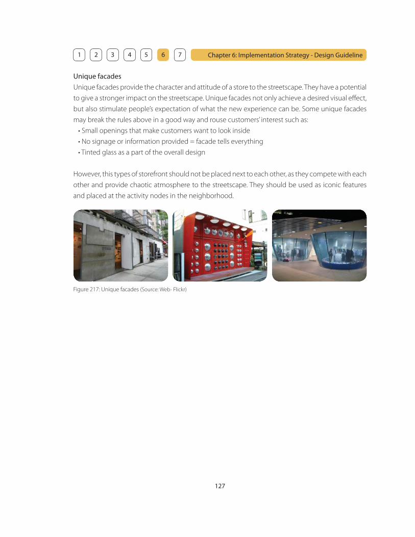
127
Chapter 6: Implementation Strategy - Design Guideline 1 2 3 4 5 6 7
Unique facades
Unique facades provide the character and attitude of a store to the streetscape. They have a potential
to give a stronger impact on the streetscape. Unique facades not only achieve a desired visual eff ect,
but also stimulate people’s expectation of what the new experience can be. Some unique facades
may break the rules above in a good way and rouse customers’ interest such as:
• Small openings that make customers want to look inside
• No signage or information provided = facade tells everything
• Tinted glass as a part of the overall design
However, this types of storefront should not be placed next to each other, as they compete with each
other and provide chaotic atmosphere to the streetscape. They should be used as iconic features
and placed at the activity nodes in the neighborhood.
Figure 217: Unique facades (Source: Web- Flickr)
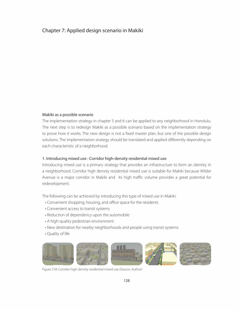
128
Chapter 7: Applied design scenario in Makiki
Makiki as a possible scenario
The implementation strategy in chapter 5 and 6 can be applied to any neighborhood in Honolulu.
The next step is to redesign Makiki as a possible scenario based on the implementation strategy
to prove how it works. The new design is not a fi xed master plan, but one of the possible design
solutions. The implementation strategy should be translated and applied diff erently depending on
each characteristic of a neighborhood.
1. Introducing mixed use : Corridor high-density residential mixed use
Introducing mixed use is a primary strategy that provides an infrastructure to form an identity in
a neighborhood. Corridor high density residential mixed use is suitable for Makiki because Wilder
Avenue is a major corridor in Makiki and its high traffi c volume provides a great potential for
redevelopment.
The following can be achieved by introducing this type of mixed use in Makiki:
• Convenient shopping, housing, and offi ce space for the residents
• Convenient access to transit systems
• Reduction of dependency upon the automobile
• A high-quality pedestrian environment
• New destination for nearby neighborhoods and people using transit systems
• Quality of life
Figure 218: Corridor high-density residential mixed use (Source: Author)

129
Chapter 7: Applied design scenario in Makiki 1 2 3 4 5 6 7
2. Secondary transit feeder systems
Secondary transit feeder systems are accessible within a distance of one to two blocks. Red Line is
from the future transit system at Ala Moana. Blue Line is from the University of Hawaii. As these two
lines have a potential to carry a large number of people to Makiki, they should run more frequently
than other lines on dedicated lanes.
Red Line (Ala Moana - Makiki Line) - Run every 5 minutes
Blue Line (College Line) - Run every 5 minutes
Major Node
Figure 219: Secondary feeder system Map (Source: Author)
Figure 220: Perspective view at the major node (Source: Author)

131
Chapter 7: Applied design scenario in Makiki 1 2 3 4 5 6 7
3. Zoning change
AMX should be introduced in Makiki, as it is desirable to maintain the character of Makiki primarily as
an apartment neighborhood along Wilder Avenue. Based on the mixed use analysis, corridor high-
density residential mixed use is suitable for Makiki. Therefore, parcels along Wilder Avenue should
be converted into AMX-2 and AMX-3. AMX-3 should be applied to high-density area along wilder
between Keeaoumoku Street and Pensacola Street, as this section is the most active area. AMX-2
should be applied to the rest of the area which is mid-density along Wilder Avenue, and parcels
along Keeaoumoku Street and Pensacola Street, as Red Line (Ala Moana - Makiki Line) runs along
those streets.
AMX-2 (Mid-density Apartment mixed use District)
AMX-3 (High-density Apartment mixed use District)
A-1 (Low-density Apartment District)
A-2 (Mid-density Apartment District)
R-5 (Residential District)
P-2 (General Preservation District)
Historical Buildings
Figure 222: Zoning change (Source: Author)
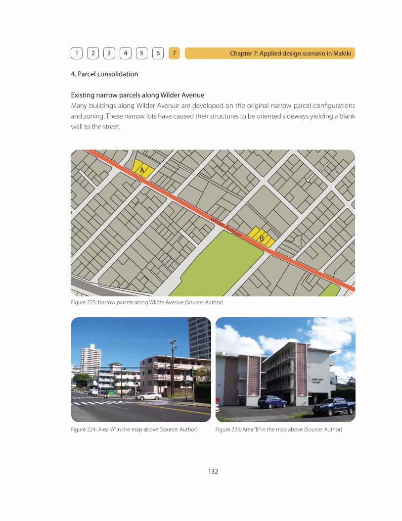
132
Chapter 7: Applied design scenario in Makiki 1 2 3 4 5 6 7
4. Parcel consolidation
Existing narrow parcels along Wilder Avenue
Many buildings along Wilder Avenue are developed on the original narrow parcel confi gurations
and zoning. These narrow lots have caused their structures to be oriented sideways yielding a blank
wall to the street.
Figure 223: Narrow parcels along Wilder Avenue (Source: Author)
Wilder Avenue
A
B
Figure 224: Area “A” in the map above (Source: Author) Figure 225: Area “B” in the map above (Source: Author)

133
Chapter 7: Applied design scenario in Makiki 1 2 3 4 5 6 7
Parcel consolidation
Parcel consolidation is highly recommended in Makiki as a number of parcels are narrow along
Wilder Avenue yielding blank wall to the street.
Figure 226: Existing condition (Source: Author) Figure 227: Proposed condition (Source: Author)
Figure 228: Existing condition (Source: Author) Figure 229: Proposed condition (Source: Author)
When parcel consolidation is not possible
Even when parcel consolidation is not possible, it is encouraged to provide openings or storefronts
facing Wilder Avenue to foster pedestrian friendly streetscape.

134
Chapter 7: Applied design scenario in Makiki 1 2 3 4 5 6 7
5. Zoning modifi cation
Existing maximum heights in Makiki
Approximately 70% of Makiki is zoned as A-2 (Medium-density Apartment district). Maximum
height for A-2 is usually 150 feet. However, Makiki is located within Punchbowl special district and
maximum heights are designated as follows:
25 feet
30 feet
40 feet
60 feet
100 feet
Figure 230: Maximum heights (Source: Author)

135
Chapter 7: Applied design scenario in Makiki 1 2 3 4 5 6 7
Maximum building area, density, and height in AMX-2 zone
The modifi cation is based on the implementation strategy in Chapter 5.
• The building area is maximized
• Parking requirement is met, also used for shared parking
• Density is increased according to the open space provided
• Maximum height is increased by 10 feet according to the height setback provided
The yellow box shown in the fi gure 234 represents the building envelope of existing maximum
height and setback.
Figure 231: Existing maximum building area (Source: Author) Figure 232: Parking structure provided (Source: Author)
Figure 233: Proposed building (Source: Author) Figure 234: Maximum height and setback (Source: Author)
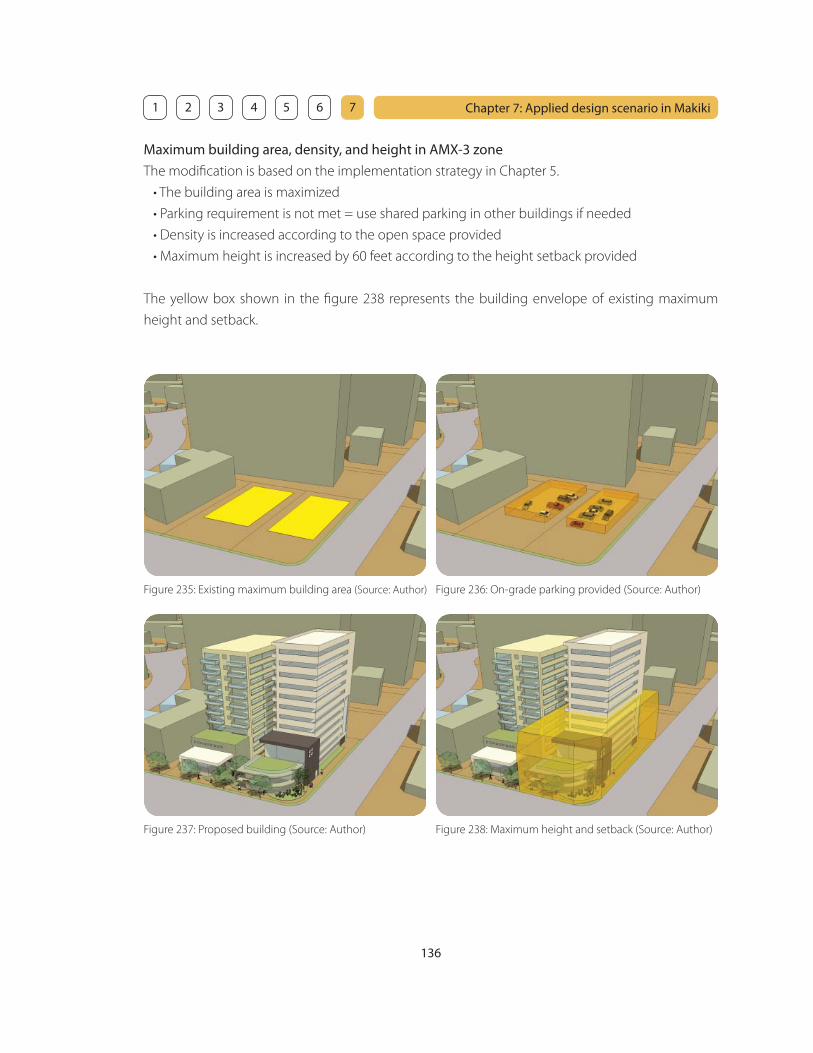
136
Chapter 7: Applied design scenario in Makiki 1 2 3 4 5 6 7
Maximum building area, density, and height in AMX-3 zone
The modifi cation is based on the implementation strategy in Chapter 5.
• The building area is maximized
• Parking requirement is not met = use shared parking in other buildings if needed
• Density is increased according to the open space provided
• Maximum height is increased by 60 feet according to the height setback provided
The yellow box shown in the fi gure 238 represents the building envelope of existing maximum
height and setback.
Figure 235: Existing maximum building area (Source: Author) Figure 236: On-grade parking provided (Source: Author)
Figure 237: Proposed building (Source: Author) Figure 238: Maximum height and setback (Source: Author)
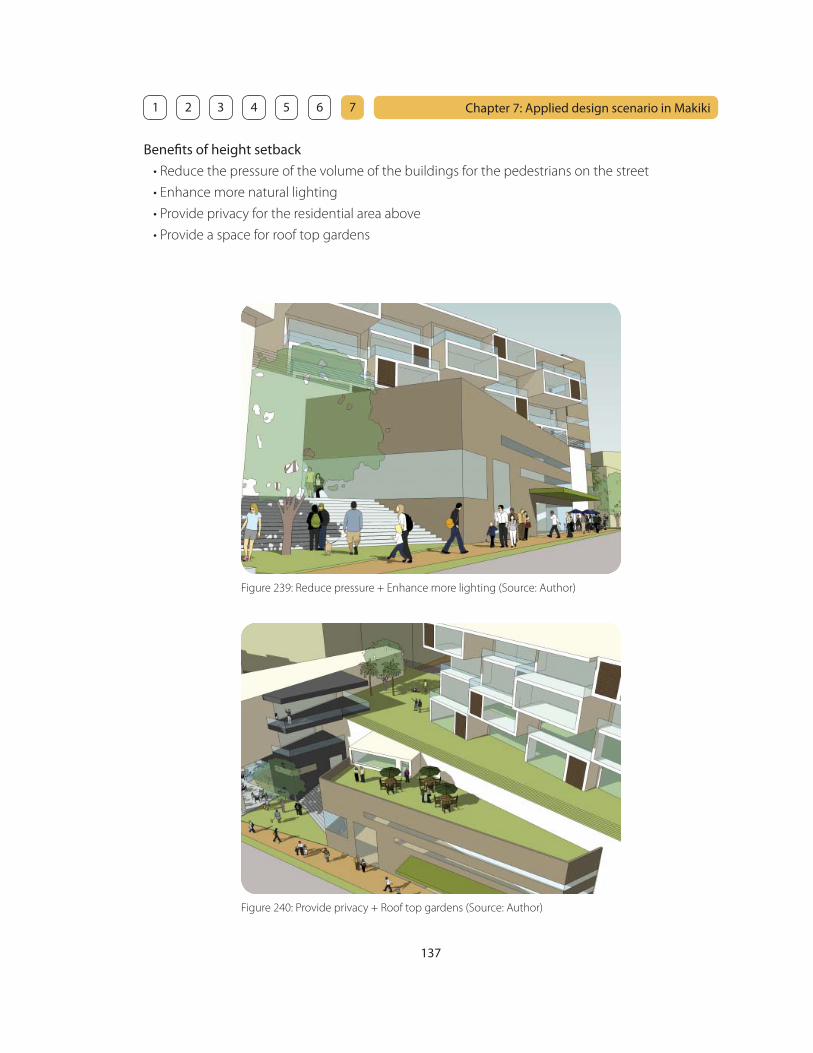
137
Chapter 7: Applied design scenario in Makiki 1 2 3 4 5 6 7
Benefi ts of height setback
• Reduce the pressure of the volume of the buildings for the pedestrians on the street
• Enhance more natural lighting
• Provide privacy for the residential area above
• Provide a space for roof top gardens
Figure 239: Reduce pressure + Enhance more lighting (Source: Author)
Figure 240: Provide privacy + Roof top gardens (Source: Author)
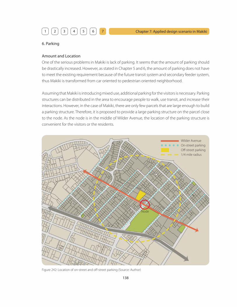
138
Chapter 7: Applied design scenario in Makiki 1 2 3 4 5 6 7
6. Parking
Amount and Location
One of the serious problems in Makiki is lack of parking. It seems that the amount of parking should
be drastically increased. However, as stated in Chapter 5 and 6, the amount of parking does not have
to meet the existing requirement because of the future transit system and secondary feeder system,
thus Makiki is transformed from car oriented to pedestrian oriented neighborhood.
Assuming that Makiki is introducing mixed use, additional parking for the visitors is necessary. Parking
structures can be distributed in the area to encourage people to walk, use transit, and increase their
interactions. However, in the case of Makiki, there are only few parcels that are large enough to build
a parking structure. Therefore, it is proposed to provide a large parking structure on the parcel close
to the node. As the node is in the middle of Wilder Avenue, the location of the parking structure is
convenient for the visitors or the residents.
Figure 242: Location of on-street and off -street parking (Source: Author)
Wilder Avenue
On-street parking
Off -street parking
1/4 mile radius
Node

141
Chapter 7: Applied design scenario in Makiki 1 2 3 4 5 6 7
8. Diversity of architectural styles and building types
It is important to provide various architectural styles and building types in order to enhance the
characteristics and avoid a homogeneous streetscape in Makiki. However, as stated in Chapter 6, it
is extremely diffi cult to control architectural style and design. It is also hard to defi ne what is good
design and what is not especially when there are very few examples in the neighborhood. The best
way would be to create one or two noticeable buildings in the area so that others can follow those
buildings as precedents.
The fi gures below are examples showing how a diversity of architectural styles and building types
can make the streetscape interesting and vibrant. This is especially so when buildings are:
• composed of multiple components instead of just one large single “box” volume
• integrated with public space
• properly landscaped
• provided with fl at roofs that can be used for gardens
Figure 250: Architectural style 1 (Source: Author)
Figure 252: Architectural style 3 (Source: Author)
Figure 251: Architectural style 2 (Source: Author)
Figure 253: Architectural style 4 (Source: Author)

142
Chapter 7: Applied design scenario in Makiki 1 2 3 4 5 6 7
9. Landscape
Street trees
Street trees play important roles for a neighborhood, as they enrich the streetscape, provide shading,
and provide pleasant walking experience. Although there are some street trees in Makiki at present,
they are not playing their roles because they are not well maintained, and they are not planted
continuously.
Landscaped medians are encouraged, as they provide more shading, soften the hard surface of the
wide road, and they slow down the traffi c in order to create a pedestrian friendly environment.
Figure 255: Existing condition (Source: Author) Figure 256: Proposed condition (Source: Author)
Figure 254: Landscape plan for street trees (Source: Author)
Wilder Avenue
Keea
oumoku
Str
eet

144
Chapter 7: Applied design scenario in Makiki 1 2 3 4 5 6 7
10. Storefront
As stated in Chapter 6, storefronts play a great role in helping to attract people by providing visual
complexity in the urban environment.
The physical design of the proposed mixed use corridor along Wilder Avenue would contribute
to the overall image of Makiki. Good design of a storefront also gives distinctive characteristics
and identity to the building and makes it valuable. Storefronts should be designed uniquely with
good qualities based on the design guideline provided in Chapter 6 in order to attract residents,
customers, and visitors, and provide a vibrant streetscape.
Figure 262: Storefront 1 (Source: Author)
Figure 264: Storefront 3 (Source: Author)
Figure 263: Storefront 2 (Source: Author)
Figure 265: Storefront 4 (Source: Author)

145
Chapter 7: Applied design scenario in Makiki 1 2 3 4 5 6 7
Figure 266: Existing Makiki - Three factors that create places where identity can evolve (Source: Author)
11. Conclusion
Evolving identity over applied identity
The initial purpose of this project was to investigate the methodology of creating an identity in a
neighborhood. However, it is learned throughout this project that an identity should not be applied
in a specifi c way, but it should evolve over time with people in diff erent places. For example, it
is not appropriate to create a Japan town just because the dominant cultural background in a
neighborhood is currently Japanese. In 10 years, the dominant cultural background may become
Chinese or Korean. As trends change, it is important to create fl exible and timeless places where
identity can evolve over time in a neighborhood.
It is stated in Chapter 4 that there are three important factors that make an identity. In fact, they
are the factors that create places where identity can evolve. The three factors are culture, public
space and activities. These important factors can be measured by fi ve basic elements; diversity,
experience, appearance, comfort, and fl exibility. By using the identity measurement tool in Chapter
4, it is possible to observe how the implementation strategies in Chapter 5 and 6 is applied to the
design scenario in Makiki in Chapter 7 and whether they work well or not for creating places where
identity can evolve in a neighborhood.
Figure 267: Proposed Makiki - Three factors that create places where identity can evolve (Source: Author)
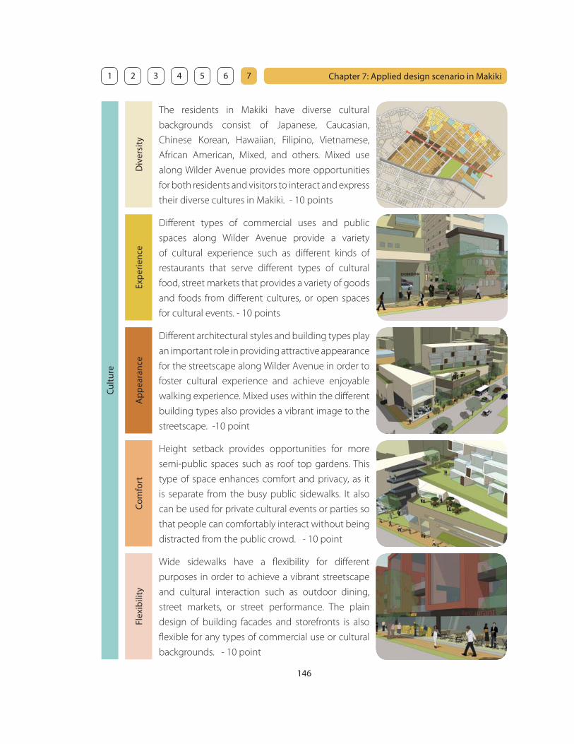
146
Chapter 7: Applied design scenario in Makiki 1 2 3 4 5 6 7
The residents in Makiki have diverse cultural
backgrounds consist of Japanese, Caucasian,
Chinese Korean, Hawaiian, Filipino, Vietnamese,
African American, Mixed, and others. Mixed use
along Wilder Avenue provides more opportunities
for both residents and visitors to interact and express
their diverse cultures in Makiki. - 10 points
Cul
ture
Div
ersi
tyEx
per
ienc
eA
pp
eara
nce
Com
fort
Flex
ibili
ty
Diff erent types of commercial uses and public
spaces along Wilder Avenue provide a variety
of cultural experience such as diff erent kinds of
restaurants that serve diff erent types of cultural
food, street markets that provides a variety of goods
and foods from diff erent cultures, or open spaces
for cultural events. - 10 points
Height setback provides opportunities for more
semi-public spaces such as roof top gardens. This
type of space enhances comfort and privacy, as it
is separate from the busy public sidewalks. It also
can be used for private cultural events or parties so
that people can comfortably interact without being
distracted from the public crowd. - 10 point
Wide sidewalks have a fl exibility for diff erent
purposes in order to achieve a vibrant streetscape
and cultural interaction such as outdoor dining,
street markets, or street performance. The plain
design of building facades and storefronts is also
fl exible for any types of commercial use or cultural
backgrounds. - 10 point
Diff erent architectural styles and building types play
an important role in providing attractive appearance
for the streetscape along Wilder Avenue in order to
foster cultural experience and achieve enjoyable
walking experience. Mixed uses within the diff erent
building types also provides a vibrant image to the
streetscape. -10 point

147
Chapter 7: Applied design scenario in Makiki 1 2 3 4 5 6 7
Pub
lic s
pac
eA diversity of public spaces provides opportunities
for the residents and visitors in Makiki to gather and
interact such as large parks, pocket parks, outdoor
dining, plazas, or wide sidewalks. In order to achieve
great public spaces, it is important that there are
diff erent destinations and people can make choices
from diff erent options. - 10 points
Div
ersi
tyEx
per
ienc
eA
pp
eara
nce
Com
fort
Flex
ibili
ty
Diff erent types of public spaces provide diff erent
experiences. It is also important that one public
space can provide multiple experiences. For
example, the park provides a water feature for
adults to visually enjoy and for kids to play. It is also
for exercising, picnic, or just reading books under
the shading trees. - 10 points
Public spaces should provide comfort such as
seating for people to take a rest and relax after or
in between their activities. Cafe can provide a space
for people who want to take a break after shopping.
Street trees provide comfortable shading for the
pedestrians. A water feature provides visual comfort
and cooling eff ect. - 10 point
Public space should be fl exible for diff erent
purposes in order to achieve a vibrant streetscape
and foster cultural interaction. Those spaces include
open lawn area, wide sidewalks, or plazas. Seating in
this type of public space should be movable so that
they can be removed for a purpose that requires a
large open space. - 10 point
Landscape plays an important role in providing an
attractive appearance and pleasant environment
of public spaces. Well designed landscape with a
variety of beautiful plants provides visual comfort as
well as spatial defi nition. It also cultivate the cultural
awareness and creates connection between people
and nature. -10 point

148
Chapter 7: Applied design scenario in Makiki 1 2 3 4 5 6 7
Act
iviti
esThere are diff erent activities especially at the node.
Makiki District Park provides a number of activities
including gardening, running, soccer, basketball,
tennis, swimming or skateboard. The mixed
use provides other activities such as gathering,
interacting, shopping, dining, working, or just
walking along Wilder Avenue. - 10 points
Div
ersi
tyEx
per
ienc
eA
pp
eara
nce
Com
fort
Flex
ibili
ty
A variety of activities provide diff erent experiences
for both residents and visitors. The experiences in
the pocket parks is diff erent from the experiences
in Makiki District Park. Diff erent types and mixture
of commercial uses in diff erent building types
provides a vibrant streetscape and enjoyable
walking experience. - 10 points
The secondary transit feeder system plays and
important role in supporting the activities along
the mixed use commercial corridor along Wilder
Avenue. As the secondary feeder system runs every
5 minutes, people can easily catch it and travel
comfortably along Wilder Avenue and get wherever
they want. - 10 point
There are a variety of fl exible public spaces that allow
diff erent types of activities such as open lawn area,
courtyards, plazas, or wide sidewalks. Wide stairs
also could be used for diff erent types of activities
other than just going upstairs or downstairs, such as
seating for street performance, outdoor concert, or
just hanging out. - 10 point
A variety activities play an important role in providing
attractive appearance. In order to achieve a vibrant
streetscape, it is important that diff erent activities
can be seen from the street. Mixed use and diff erent
types of public spaces along Wilder Avenue provide
diff erent activities and make the street enjoyable
and exiting. -10 point

149
Chapter 7: Applied design scenario in Makiki 1 2 3 4 5 6 7
This project is a starting point
The purpose of this project is to investigate the methodology of creating a neighborhood where
identity can evolve. It is not intended to act as a totally new standard replaced with the existing
standard, but as a trigger for diff erent individuals related to the neighborhood to think about
diff erent possibilities to make their neighborhood into a great place. Most residents want to make
their neighborhood into a better place. However, a lot of them do not know the methodologies or
the possibilities to make it happen.
One way is to educate the residents by presenting this project to a neighborhood board. Another
way is to present it to the City and County of Honolulu in order to provide another view point for
a neighborhood, as they are occupied with the existing condition and typical methodology. When
they are inspired by this project, they could hire developers or planners to actually start detailed
research on the neighborhood and come up with a master plan.
The next step is to hire good architects to design new buildings or renovate existing buildings. It is
also ideal to hire Landscape architects and work together with the architects, as landscape should
be designed professionally and integrated with the buildings and public places in order to create
pleasant and enjoyable spaces suitable for the urban environment. However, projects often change
over time during the process because of the budget or time and do not accomplish the initial goal.
Therefore, a design review team elected based on the criteria of this project could monitor the
process of the planning and designing in order to achieve the initial goal.
As stated in Chapter 1, neighborhoods in Honolulu have become homogeneous and it is diffi cult
to make changes of existing methodology that is effi cient, but not unique because of developers
desire to maximize profi ts and planners use of effi ciently repeatable housing models. However,
the relationship between a neighborhood and cultures, or people and their environment cannot
be viewed in a deterministic or simplistic manner. I strongly wish that this project could become
a key to open the door to another perspective for diff erent individuals and help them create a
neighborhood where identity can evolve.


![Unternehmergespräche auf der Kronenburg [kronenburg.biz] Neues Kündigungsschutzrecht 2004.](https://static.fdocuments.net/doc/165x107/55204d6249795902118b63d8/unternehmergespraeche-auf-der-kronenburg-kronenburgbiz-neues-kuendigungsschutzrecht-2004.jpg)