METHOD OF WCS CLIENT BASED ON PYRAMID … paper proposes a method of WCS client based on pyramid...
6
METHOD OF WCS CLIENT BASED ON PYRAMID MODEL Shen Shengyu, Wu Huayi * State Key Laboratory of Information Engineering in Surveying, Mapping and Remote Sensing, Wuhan University, 430079 Wuhan, China - [email protected], - [email protected] KEY WORDS: WCS, Pyramid Model, Client, Spatial Image, Local Cache ABSTRACT: As a non-profit, international, voluntary consensus standards organization, OGC and ISO/TC211 have been dedicating to develop standards for geospatial and location based services. WMS and WCS are two typical geospatial standards of OGC proposed geospatial standard family. A lot of servers have been setup to provide WMS and WCS for sharing and interoperating geospatial information. However, there are still many issues in quality of geospatial information service (QoGIS) for deploying and maintaining a real-time and non-interruptedly running system of sharing geospatial information. This paper proposes a method of WCS client based on pyramid model. On the client side, spatial images are stored in local cache in the structure of pyramid model. The experiment shows that this method brings out the effect of multi-resolution spatial images displayed dynamically and rapidly in 3D environment. And in addition, thematic layers from WMS are overlapped on WCS, which gives out more potential information. Because only client side is involved in this method and requires nothing for WCS server except the OGC standard specified, it is well worth applying to application. * Corresponding author. 1. INTRODUCTION Among standards based on the Implementation Specification of Web Services that OGC (Open Geospatial Consortium) and ISO/TC211 advocate, the WCS supports electronic interchange of geospatial data as "coverages" – that is, digital geospatial information representing space-varying phenomena. WCS provides three operations: GetCapabilities, GetCoverage, and DescribeCoverage. The GetCapabilities operation returns an XML document describing the service and brief descriptions of the data collections from which clients may request coverages. The DescribeCoverage operation lets clients request a full description of one or more coverages served by a particular WCS server. The server responds with an XML document that fully describes the identified coverages. The GetCoverage operation of a Web Coverage Service is normally run after GetCapabilities and DescribeCoverage replies have shown what requests are allowed and what data are available. The GetCoverage operation returns a coverage (that is, values or properties of a set of geographic locations), bundled in a well-known coverage format. (OGC, 2003) At present, many world famous satellite imagery viewers, such as Google Earth, Microsoft Virtual Earth and etc, store and publish spatial image data in their own formats. They integrate the satellites imagery and aerophotograph, and implement the rapid, multi-resolution display of massive amount of spatial data. In some degree, they are self-defined WCS. The variety of storage and publish and the secrecy of commerce severally blocked the sharing of geospatial information. The problem is solved in some degree by the standards of OGC. However, there are still many issues in quality of geospatial information service (QoGIS) in implementing the sharing of geospatial information with WCS. The first one is speed of request-response. Not only server’s computing capability but also network transmission speed influence efficiency of data access during sending out GetCoverage request and displaying spatial images in client. So how to make faster response to user’s request is the fundamental issue of advocating WCS in application. The second one is sharing of distributed data. WCS can only provide a single coverage of spatial images. Can different version and type of services be overlapped or integrated in order to give out more information? WCS standard does not restrict this theory itself. Because of error of data, bound, scale and computing method in server, the visual effect of overlap is usually not very good. The third one is that experience of manipulation such as zoom-in, zoom-out and pan is needed to be improved. For instance, through the most WCS, ordinary client needs to send request for spatial data because of any manipulation. And client will not display spatial images until they arrive. So manipulation such as zoom-in, zoom-out and pan will make user not feel very good. This paper proposes a method of WCS client based on pyramid model. On the client side, spatial images are stored in local cache in the structure of pyramid model. The experiment shows that this method brings out the effect of multi-resolution spatial images displayed dynamically and rapidly in 3D environment. And in addition, thematic layers from WMS are overlapped on WCS, which gives out more potential information. According to the experiment result, in some degree, visual effect meets some application’s needs. Because this method is involved only to client side and doesn’t have any requirement for WCS, it is well worth advocating to application. 809
Transcript of METHOD OF WCS CLIENT BASED ON PYRAMID … paper proposes a method of WCS client based on pyramid...
METHOD OF WCS CLIENT BASED ON PYRAMID MODEL
Shen Shengyu, Wu Huayi*
State Key Laboratory of Information Engineering in Surveying, Mapping and Remote Sensing, Wuhan University,
430079 Wuhan, China - [email protected], - [email protected] KEY WORDS: WCS, Pyramid Model, Client, Spatial Image, Local Cache ABSTRACT: As a non-profit, international, voluntary consensus standards organization, OGC and ISO/TC211 have been dedicating to develop standards for geospatial and location based services. WMS and WCS are two typical geospatial standards of OGC proposed geospatial standard family. A lot of servers have been setup to provide WMS and WCS for sharing and interoperating geospatial information. However, there are still many issues in quality of geospatial information service (QoGIS) for deploying and maintaining a real-time and non-interruptedly running system of sharing geospatial information. This paper proposes a method of WCS client based on pyramid model. On the client side, spatial images are stored in local cache in the structure of pyramid model. The experiment shows that this method brings out the effect of multi-resolution spatial images displayed dynamically and rapidly in 3D environment. And in addition, thematic layers from WMS are overlapped on WCS, which gives out more potential information. Because only client side is involved in this method and requires nothing for WCS server except the OGC standard specified, it is well worth applying to application.
* Corresponding author.
1. INTRODUCTION
Among standards based on the Implementation Specification of Web Services that OGC (Open Geospatial Consortium) and ISO/TC211 advocate, the WCS supports electronic interchange of geospatial data as "coverages" – that is, digital geospatial information representing space-varying phenomena. WCS provides three operations: GetCapabilities, GetCoverage, and DescribeCoverage. The GetCapabilities operation returns an XML document describing the service and brief descriptions of the data collections from which clients may request coverages. The DescribeCoverage operation lets clients request a full description of one or more coverages served by a particular WCS server. The server responds with an XML document that fully describes the identified coverages. The GetCoverage operation of a Web Coverage Service is normally run after GetCapabilities and DescribeCoverage replies have shown what requests are allowed and what data are available. The GetCoverage operation returns a coverage (that is, values or properties of a set of geographic locations), bundled in a well-known coverage format. (OGC, 2003) At present, many world famous satellite imagery viewers, such as Google Earth, Microsoft Virtual Earth and etc, store and publish spatial image data in their own formats. They integrate the satellites imagery and aerophotograph, and implement the rapid, multi-resolution display of massive amount of spatial data. In some degree, they are self-defined WCS. The variety of storage and publish and the secrecy of commerce severally blocked the sharing of geospatial information. The problem is solved in some degree by the standards of OGC.
However, there are still many issues in quality of geospatial information service (QoGIS) in implementing the sharing of geospatial information with WCS. The first one is speed of request-response. Not only server’s computing capability but also network transmission speed influence efficiency of data access during sending out GetCoverage request and displaying spatial images in client. So how to make faster response to user’s request is the fundamental issue of advocating WCS in application. The second one is sharing of distributed data. WCS can only provide a single coverage of spatial images. Can different version and type of services be overlapped or integrated in order to give out more information? WCS standard does not restrict this theory itself. Because of error of data, bound, scale and computing method in server, the visual effect of overlap is usually not very good. The third one is that experience of manipulation such as zoom-in, zoom-out and pan is needed to be improved. For instance, through the most WCS, ordinary client needs to send request for spatial data because of any manipulation. And client will not display spatial images until they arrive. So manipulation such as zoom-in, zoom-out and pan will make user not feel very good. This paper proposes a method of WCS client based on pyramid model. On the client side, spatial images are stored in local cache in the structure of pyramid model. The experiment shows that this method brings out the effect of multi-resolution spatial images displayed dynamically and rapidly in 3D environment. And in addition, thematic layers from WMS are overlapped on WCS, which gives out more potential information. According to the experiment result, in some degree, visual effect meets some application’s needs. Because this method is involved only to client side and doesn’t have any requirement for WCS, it is well worth advocating to application.
809
The International Archives of the Photogrammetry, Remote Sensing and Spatial Information Sciences. Vol. XXXVII. Part B4. Beijing 2008
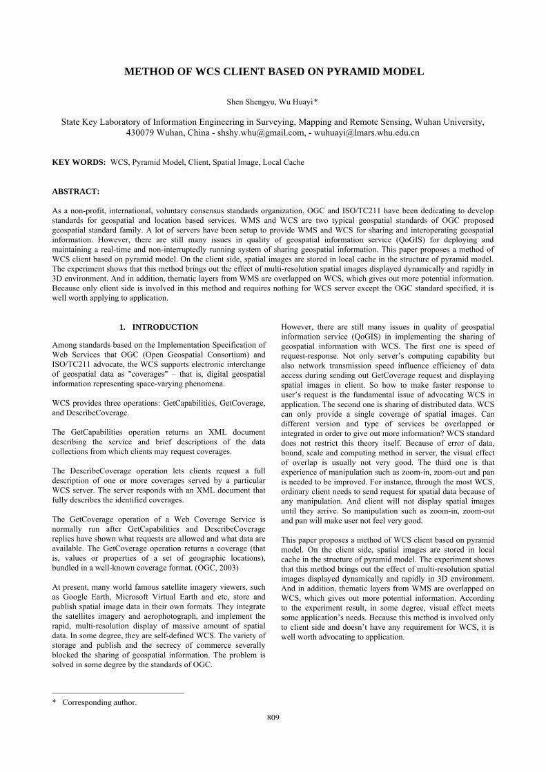
2. MANAGEMENT OF SPATIAL IMAGES IN CLIENT
On the client side, capability document is requested by the mandatory operation GetCapabilities of WCS. Service version and simple information of coverages such as name, bounding box is parsed from the capability document. And then with capability information, coverage detail such as coverage name, coordinate reference system, bounding box and supported coordinate reference system and etc can be get from the mandatory operation DescribeCoverage. Then image pyramid is built up for each coverage, that is to say, each coverage is an pyramid object. The number of pyramid level and quad tiles are decided dynamically by the coverage detail information. For quad tile, the global zero-level coverage consists of 50 quad tiles whose latitude and longitude are both 36 degree for convenience. The smaller one can be picked up from latitude and longitude. Then the zero level latitude and longitude of the coverage pyramid can be computed by halving 36 repeatedly until that it is bigger than the latter for first time. And the level number of the coverage pyramid can be the result of the initial total level number minus the times halving 36 repeatedly. In order to improve display performance, reduce the number of client requests sent to the server and reduce the load on network transmission, this method stores spatial images got from the server side in local cache on the client side. In order to search and load data rapidly, the spatial images on client side is stored in the tree and pyramid structure. The store path of spatial images is illustrated in Figure 1. The name of first level is the service type name WCS. The names of second level are the services names, such as dee and ssy. The names of third level are the coverage names of service, A denotes saltlake, B demotes europe. The names of fourth level are the level number of the pyramid, such as 0, 1, 2, 3 and etc. The names of fifth level are the column numbers in which this spatial image is in current regulated globe grid, such as 0027, 0028 and so on. The last level is the spatial image set named by column number and row number.
Figure 1. The store path of spatial images
When a request of spatial image data is issued, client will first examine whether the request data are in client. If they are, client will display them immediately. Otherwise data request will be created. Through the operation GetCoverage of WCS, spatial images acquired are stored in local cache and then displayed on the client side. This is a dynamic request and cache system. In order to use data conveniently in the future and avoid data waste and repeated requests, local cache is not deleted when user closes the client. When client restarts, data in local cache is
still there. But before data being used, service list should be searched from the server. If services are updated, the content of local cache should be updated too by comparing to the service list on server side. For instance, if a new service is added, a new folder will be created to store spatial images as its local cache. If a service is deleted, meanwhile its data in local cache will be deleted too.
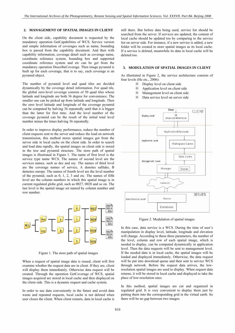
3. MODULATION OF SPATIAL IMAGES IN CLIENT
As illustrated in Figure 2, the service architecture consists of four levels (He etc., 2006):
※ Display level on client side ※ Application level on client side ※ Management level on client side ※ Data service level on server side
Figure 2. Modulation of spatial images
In this case, data service is a WCS. During the time of user’s manipulation in display level, latitude, longitude and elevation will change. According to these three parameters, the number of the level, column and row of each spatial image, which is needed to display, can be computed dynamically in application level. Then the data requests will be sent to management level. If the needed data is in local cache, the spatial images will be loaded and displayed immediately. Otherwise, the data request will be put into download queue and then sent to service WCS through network. Before the request data arrives, the low-resolution spatial images are used to display. When request data returns, it will be stored in local cache and displayed to take the place of low-resolution ones. In this method, spatial images are cut and organized in regulated grid. It is very convenient to display them just by putting them into the corresponding grid in the virtual earth. So there will be no gap between two images.
810

The International Archives of the Photogrammetry, Remote Sensing and Spatial Information Sciences. Vol. XXXVII. Part B4. Beijing 2008
4. EXPERIMENT
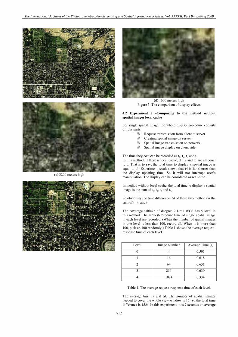
This method is implemented by integrated to GeoGlobe, a 3D digital earth system developed by LIESMARS, Wuhan University. GeoGlobe is a powerful visual client of virtual earth, which can display real-time multi-resolution spatial images and terrain data by acquiring them from server through network.(Shen, 2007) This experiment system is developed on Microsoft Visual Studio 2005, and programming language is C#. 3D engine is DirectX 9.0C. Server is a HP Blade Server (CPU Inter(R) Xeon(R) CUP 5110 @ 1.60GHz. 1.6GHz RAM 4.00GB). Tomcat 5.5 is used as service container. The experiment data are deegree 2.1-rc1 WCS (Deegree, 2006a) and deegree 2.1-rc1 WMS (Deegree, 2006b). The two services are deployed in LAN. In this case, the data transmission is not effected by factors such as bandwidth, net gate and etc. GeoGlobe supports Geodetic Coordinate System (latitude and longitude), but according to the operation DescribeCoverage, it shows that the saltlake coverage of deegree 2.1-rc1 WCS supports only EPSG:26912 which is a plane rectangular coordinate system based on WGS84 ellipse and UTM projection. So a projection transformation is used in client before creating a GetCoverage request. 4.1 Experiment 1 –Comparing to the method without multi-resolution pyramid
Figure 3 shows the comparison of display effects with these two methods. In each pair, the first one is the display effect figure with this method and the second is the one without. Figure 3(a) shows the display effect at 8000 meters high. Figure 3(b) shows the display effect at 6400 meters high. Figure 3(c) shows the display effect at 3200 meters high. Figure 3(d) shows the display effect at 8000 meters high. Although the four with this method present the same visual resolution, the spatial resolutions of the last three are 2, 4 and 8 times as the first one and the corresponding one in the same pair.
(a) 8000 meters high
(b) 6400 meters high
811
The International Archives of the Photogrammetry, Remote Sensing and Spatial Information Sciences. Vol. XXXVII. Part B4. Beijing 2008
(c) 3200 meters high
(d) 1600 meters high
Figure 3. The comparison of display effects 4.2 Experiment 2 –Comparing to the method without spatial images local cache
For single spatial image, the whole display procedure consists of four parts:
※ Request transmission form client to server ※ Creating spatial image on server ※ Spatial image transmission on network ※ Spatial image display on client side
The time they cost can be recorded as t1, t2, t3 and t4. In this method, if there is local cache, t1, t2 and t3 are all equal to 0. That is to say, the total time to display a spatial image is equal to t4. Experiment result shows that t4 is far shorter than the display updating time. So it will not interrupt user’s manipulation. The display can be considered as real-time. In method without local cache, the total time to display a spatial image is the sum of t1, t2, t3 and t4. So obviously the time difference Δt of these two methods is the sum of t1, t2 and t3. The coverage saltlake of deegree 2.1-rc1 WCS has 5 level in this method. The request-response time of single spatial image in each level are recorded. (When the number of spatial images in one level is less than 100, record all. When it is more than 100, pick up 100 randomly.) Table 1 shows the average request-response time of each level.
Level Image Number Average Time (s)
0 4 0.503
1 16 0.618
2 64 0.651
3 256 0.630
4 1024 0.334
Table 1. The average request-response time of each level.
The average time is just Δt. The number of spatial images needed to cover the whole view window is 15. So the total time difference is 15Δt. In this experiment, it is 7 seconds on average.
812
The International Archives of the Photogrammetry, Remote Sensing and Spatial Information Sciences. Vol. XXXVII. Part B4. Beijing 2008
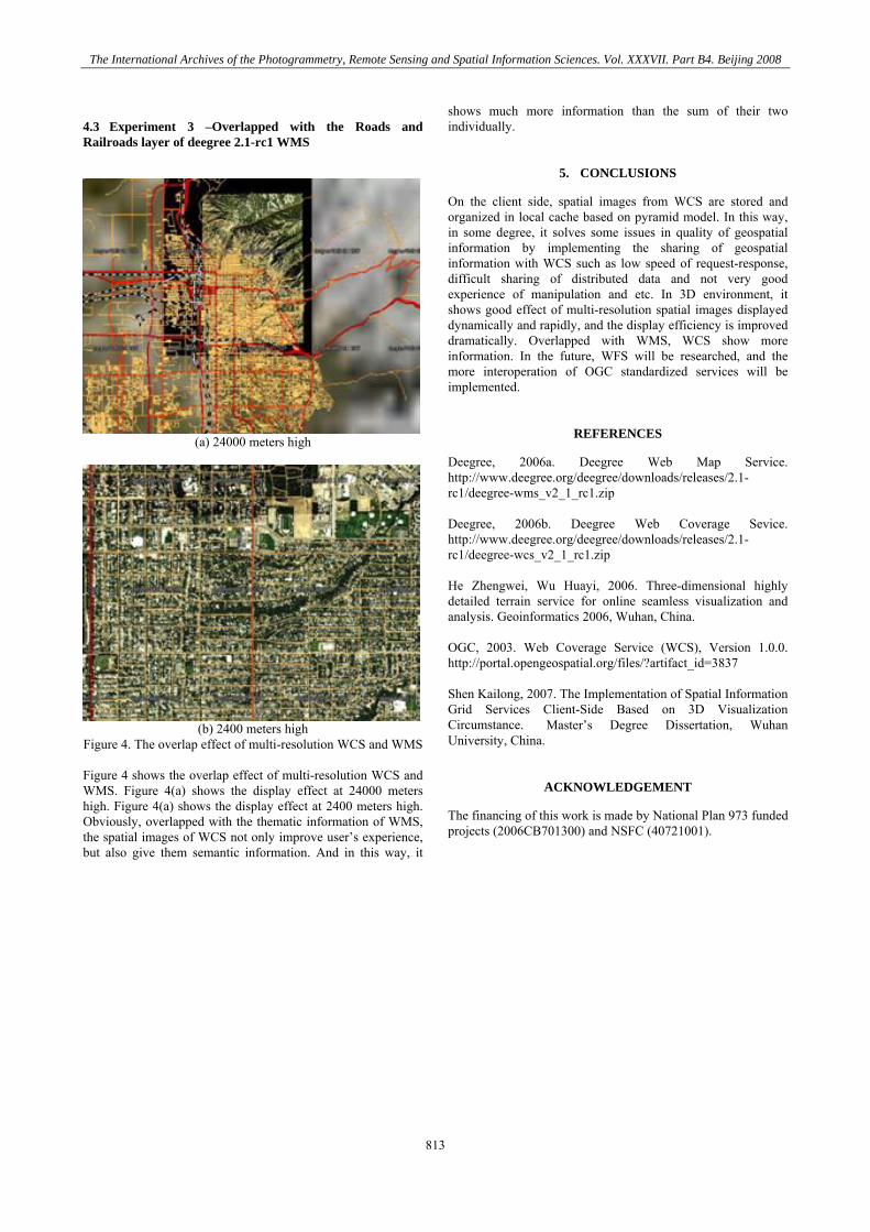
4.3 Experiment 3 –Overlapped with the Roads and Railroads layer of deegree 2.1-rc1 WMS
(a) 24000 meters high
(b) 2400 meters high
Figure 4. The overlap effect of multi-resolution WCS and WMS Figure 4 shows the overlap effect of multi-resolution WCS and WMS. Figure 4(a) shows the display effect at 24000 meters high. Figure 4(a) shows the display effect at 2400 meters high. Obviously, overlapped with the thematic information of WMS, the spatial images of WCS not only improve user’s experience, but also give them semantic information. And in this way, it
shows much more information than the sum of their two individually.
5. CONCLUSIONS
On the client side, spatial images from WCS are stored and organized in local cache based on pyramid model. In this way, in some degree, it solves some issues in quality of geospatial information by implementing the sharing of geospatial information with WCS such as low speed of request-response, difficult sharing of distributed data and not very good experience of manipulation and etc. In 3D environment, it shows good effect of multi-resolution spatial images displayed dynamically and rapidly, and the display efficiency is improved dramatically. Overlapped with WMS, WCS show more information. In the future, WFS will be researched, and the more interoperation of OGC standardized services will be implemented.
REFERENCES
Deegree, 2006a. Deegree Web Map Service. http://www.deegree.org/deegree/downloads/releases/2.1-rc1/deegree-wms_v2_1_rc1.zip Deegree, 2006b. Deegree Web Coverage Sevice. http://www.deegree.org/deegree/downloads/releases/2.1-rc1/deegree-wcs_v2_1_rc1.zip He Zhengwei, Wu Huayi, 2006. Three-dimensional highly detailed terrain service for online seamless visualization and analysis. Geoinformatics 2006, Wuhan, China. OGC, 2003. Web Coverage Service (WCS), Version 1.0.0. http://portal.opengeospatial.org/files/?artifact_id=3837 Shen Kailong, 2007. The Implementation of Spatial Information Grid Services Client-Side Based on 3D Visualization Circumstance. Master’s Degree Dissertation, Wuhan University, China.
ACKNOWLEDGEMENT
The financing of this work is made by National Plan 973 funded projects (2006CB701300) and NSFC (40721001).
813

The International Archives of the Photogrammetry, Remote Sensing and Spatial Information Sciences. Vol. XXXVII. Part B4. Beijing 2008
814


![OGC WCS: A Short Guide - Europa€¦ · Web Coverage Service (WCS) = - modular, testable, scalable ... EO-WCS WCS Application Profile for Earth Observation [OGC 10-140] - 2D imagery](https://static.fdocuments.net/doc/165x107/5fb8102767ab5c5b7f2483a0/ogc-wcs-a-short-guide-europa-web-coverage-service-wcs-modular-testable.jpg)