
Method matters in inter linking rivers
82
SECTION 5: RETICULAR CANAL SYSTEM FOR INTERLINKING INDIAN RIVERS. By, Dr. Shivu. P. No. 757, Vinayamarga, 11 th cross, Siddarthanagar, Mysore 11. PIN: 570011. Mobile number: 9448477380, Land phone: 0821 2561277, 0821 4000778 Mail: [email protected] Visit: www.slideshare.net/drshivu 1
-
Upload
shivu-p -
Category
Technology
-
view
106 -
download
1
Transcript of Method matters in inter linking rivers

SECTION 5:
RETICULAR CANAL SYSTEM FOR INTERLINKING INDIAN RIVERS.
By, Dr. Shivu. P.No. 757, Vinayamarga, 11th cross, Siddarthanagar, Mysore 11. PIN: 570011.Mobile number: 9448477380, Land phone: 0821 2561277, 0821 4000778Mail: [email protected]: www.slideshare.net/drshivu
1

Water.• Do you want Water?• Ans: Yes, No controversies for this answer.
• Is all are getting sufficient water ?• Ans: No, No controversies for this answer.
• Do you want to get the permanent solution for this water scarcity?• Ans: Yes, No controversies for this answer.
• Do you want to interlink the rivers to solve the problem of water scarcity?
• Ans: Yes And No, Many controversies for this answer.
• Why controversies aroused for ILR?• Ans: Many plans – many views with imbalance in the advantages and
disadvantages.

Interlinking Rivers.
Thought came to the peoples mind.
• Nature destruction,
• Changes to the bio
flora.
• Back water.
• Forest land
involved.
Reticular canal system – which no one knows at present.
• Protecting the nature by preventing
deforestation and desertification,
• Protecting the bio flora by proving the home
through re forestation and relakification .
• No or minimal Back water.
• Less Forest land involved facilitates
reforestation.

Interlinking Rivers.
Thought came to the peoples mind.
• Creation cost.
• Cities that are going to
immerse.
• Cutting the hills and
mountains.
• Underground canals.
Reticular canal system – which no one knows at present.
• Less Creation cost.
• No Cities are going to immerse.
• No Cutting the hills and mountains,
and it is a simple surface canal.
• No or very less Underground
canals.

Interlinking Rivers. Thought came to the peoples mind.
• Big structures – dams
and reservoirs.
• Elevations and
depressions in the
land.
• Very depressed land
between himalaya
and aravalli – vindya
mountains.
Reticular canal system – which no one knows at present.
• No Big structures – dams and reservoirs.
• Overcoming the Elevations and depressions in
the land by under standing earths surface well
and through simple structures like CE, bidams,
aquaducts, direct canal connectors.
• Shift of water across the very depressed land
between himalaya and aravalli – vindya
mountains can be managed with safe structures
like U tube.
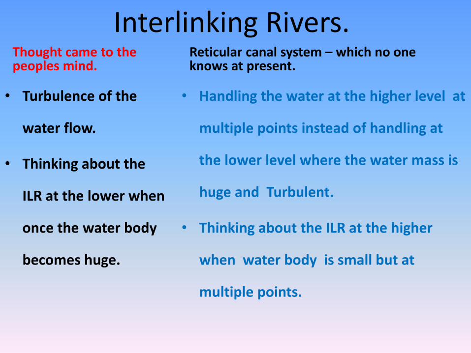
Interlinking Rivers. Thought came to the peoples mind.
• Turbulence of the
water flow.
• Thinking about the
ILR at the lower when
once the water body
becomes huge.
Reticular canal system – which no one knows at present.
• Handling the water at the higher level at
multiple points instead of handling at
the lower level where the water mass is
huge and Turbulent.
• Thinking about the ILR at the higher
when water body is small but at
multiple points.

Source [54]
Water
7
Seven percent of the world's population has not enough water.
By 2050, this will be 70 percent.
Our planet has 1,400 million million million liters of water: 100 billion liters a head.
But, 97 percent is salty and much of the rest is trapped underground or stored as polar ice.
Only 0.8 percent of the Earth's water is accessible and drinkable: about one billion billion liters.
It is enough on an average.
But some countries have too much. Others have too little.

Water
8
The nation need to understand the seriousness behind
this issue and act accordingly for the supply of water to
all the parts of the country on an emergency basis.
If we take rest for few years by not taking any serious
thought to get the water for all our people of the nation
now and if we plan the same after some years.

Water
• if we plan the same after some years by that time we
may be in a position to do the project but the
international laws may stop us not to carry out any such
projects and the people of the nation is going suffer from
the deficiency.
• The word ‘war for water’ needs to be understood
efficiently.

Reticular canal system is a new concept for Interlinking rivers.Deforestation (For example - The roots of the trees will not get sufficient water to survive with decreasing underground water level, this type of injury to the nature can involve many trees and the entire forest, we have seen the incidences like trees falling suddenly and killing the people and damaging the property as the root dries up silently),
Desertification,
Less rain,
Malnutrition / nutrition related diseases, Poverty,
Animals dying of dehydration,
Pollution,
Global warming, are the ongoing ecological disaster and we will ‘land up in grave disaster’ if we are not thinking about the solution for the same.

Reticular canal system is a new concept for Interlinking rivers.
Such expected disasters needs to be addressed with reforestation, soil conservation, preventing rural to urban migration by preventing repeated loss in agriculture, preventing uncontrolled urbanisation and so on.
All these depend on improving the rural economy, education and infrastructure.
Rural economy depends on irrigation and agriculture.

RETICULAR CANAL SYSTEM FOR INTERLINKING INDIAN RIVERS
Story of the canal:
Declining (Vertical) canal:
• I am the canal and I always run vertically down that is how you planned and crated.
Flat (Horizontal) canal:
• I am the canal and I have the ambition to run horizontally so that both my ends are at the same level that you need to plan and crate.

RETICULAR CANAL SYSTEM FOR INTERLINKING INDIAN RIVERS
Story of the canal:
Declining (Vertical) canal:
• I have only one inlet to get my water that is the reservoir / dam, that may or may not have the store of water in it always but I have multiple outlets.
Flat (Horizontal) canal:
• I can have multiple inlets in terms of hundred or thousands, why only one? to get my water , thus I hope not all of them becomes dry in a single time.

RETICULAR CANAL SYSTEM FOR INTERLINKING INDIAN RIVERS
Story of the canal:
Declining (Vertical) canal:
• If my inlet gets the water from the reservoir then I can serve you other wise I lay dry.
Flat (Horizontal) canal:
• If any one of my inlets gets the water from the catchment area, it need not be the artificial reservoir, then I can serve you all the time throughout the year and thus I will never lay dry.
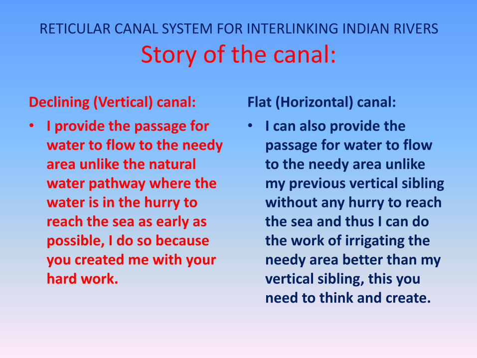
RETICULAR CANAL SYSTEM FOR INTERLINKING INDIAN RIVERS
Story of the canal:
Declining (Vertical) canal:
• I provide the passage for water to flow to the needy area unlike the natural water pathway where the water is in the hurry to reach the sea as early as possible, I do so because you created me with your hard work.
Flat (Horizontal) canal:
• I can also provide the passage for water to flow to the needy area unlike my previous vertical sibling without any hurry to reach the sea and thus I can do the work of irrigating the needy area better than my vertical sibling, this you need to think and create.

RETICULAR CANAL SYSTEM FOR INTERLINKING INDIAN RIVERS
Story of the canal:
Story of the canal:
• You have always created me on the sides of the naturally flowing water pathways may be little away but never took me out of one river basin, that means I serve the same geographical area.
Flat (Horizontal) canal:• You need to understand the
surface of the earth in a better way to create me not on the sides of the naturally flowing water pathways but I can cross all the rivers all along my course receiving the volume of water I need to serve the humanity covering not only one river basin but all the river basins whom I cross, that means I can serve different geographical areas.

RETICULAR CANAL SYSTEM FOR INTERLINKING INDIAN RIVERS
Story of the canal:
Declining (Vertical) canal:
• If no one uses my water in remote possibility then again I drain in to the same river to reach the sea.
Flat (Horizontal) canal:
• If no one uses my water in a particular area then I can take that water to other needy area even to other river basin, from north to south, south to north, east to west and west to east.
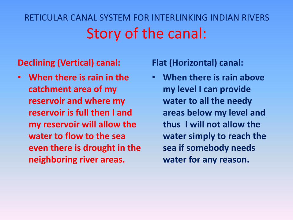
RETICULAR CANAL SYSTEM FOR INTERLINKING INDIAN RIVERS
Story of the canal:
Declining (Vertical) canal:
• When there is rain in the catchment area of my reservoir and where my reservoir is full then I and my reservoir will allow the water to flow to the sea even there is drought in the neighboring river areas.
Flat (Horizontal) canal:
• When there is rain above my level I can provide water to all the needy areas below my level and thus I will not allow the water simply to reach the sea if somebody needs water for any reason.

Comparison between the primary canals which are declining (Flow based / Unidirectional flow) and flat (Bidirectional flow).
134

Comparison between the primary canals which are declining (Unidirectional flow) and flat (Bidirectional flow).
135

Comparison between the primary canals which are declining (Unidirectional flow) and flat (Bidirectional
flow):
21135

RETICULAR CANAL SYSTEM FOR INTERLINKING INDIAN RIVERS
Story of the canal:
Declining (Vertical) canal:
• The starting point of the canal will be higher than the ending point
Flat (Horizontal) canal:
• The starting and the ending points of the canal are at the same level .

RETICULAR CANAL SYSTEM FOR INTERLINKING INDIAN RIVERS
Story of the canal:
Declining (Vertical) canal:
• The water flows from the higher end to the lower end
Flat (Horizontal) canal:
• Water will flow from the place of more water to the less water in the canal,

RETICULAR CANAL SYSTEM FOR INTERLINKING INDIAN RIVERS
Story of the canal:
Declining (Vertical) canal:
• Every drop of water which enter in to the canal will tend to move towards the lower end and accumulates there,
Flat (Horizontal) canal:
• Every drop of water which enter in to the canal will make the water level in the canal to rise all along its course and every drop of water which leaves the canal will make the level of water to decrease all along its course.

RETICULAR CANAL SYSTEM FOR INTERLINKING INDIAN RIVERS
Story of the canal:
Declining (Vertical) canal:
• The water pools at the lower end overflows if not emptied even with minimal water.
Flat (Horizontal) canal:
• There is no pooling of water at the ends or at any place in the canal, every drop of water will be equally distributed and equally accessible to all the places below the level of the canal.

RETICULAR CANAL SYSTEM FOR INTERLINKING INDIAN RIVERS
Story of the canal:
Declining (Vertical) canal:
• Law need to be enforced to decide how much water to be flown in each gate.
Flat (Horizontal) canal:
• Only one law is sufficient to maintain the water in the canal that is, ‘no water enter the sea, if there is some place called ‘drought prone’.

RETICULAR CANAL SYSTEM FOR INTERLINKING INDIAN RIVERS
Story of the canal:
Declining (Vertical) canal:
• This canal will not act as the reservoir for the water even thought there is lot of space in the canal available to accommodate the water, as all the water tends to pool in the lower end.
Flat (Horizontal) canal:
• This canal will act like a better reservoir of water in its entire course, with rain any where above its level, thus the actual and the structural capacity will correspond.

RETICULAR CANAL SYSTEM FOR INTERLINKING INDIAN RIVERS
Story of the canal:
Declining (Vertical) canal:
• If there is rain in the lower canal feeding river catchment area, then the upper canal area will not get the benefit.
Flat (Horizontal) canal:
• Rain any where above the level of the canal will fill the canal equally, which is accessible to all the lands which is below its level.

RETICULAR CANAL SYSTEM FOR INTERLINKING INDIAN RIVERS
Story of the canal:
Declining (Vertical) canal:
• The reservoir surface in terms of square kilometers is less at the beginning but will have more area to be fed, and the reservoir surface becomes more at the end but there is less land available to be fed, and that more water will enter in to the sea.
Flat (Horizontal) canal:
• The reservoir surface in terms of square kilometers remains the same all along the course of the canal and even at the ends, thus receives more water at any point of the canal.

RETICULAR CANAL SYSTEM FOR INTERLINKING INDIAN RIVERS
Story of the canal:
Declining (Vertical) canal:
• The canal comes closer to the coastal areas as the course comes to the south and thus there is a possibility that many areas will not get the water.
Flat (Horizontal) canal:
• The geographical variations may be present in terms of distance, but the canal will not go closer to the coastal area unlike the declining canal. Thus more land suitable for agriculture will get the water from the FPC.

RETICULAR CANAL SYSTEM FOR INTERLINKING INDIAN RIVERS
Story of the canal:
Declining (Vertical) canal:
• Since this is going to decline along its course, we will not get better height of water fall for establishing the hydro electrical projects.
Flat (Horizontal) canal:
• Since the FPC are at the higher level all along its course and even at its ends, thus, more hydro electrical projects can be established.

RETICULAR CANAL SYSTEM FOR INTERLINKING INDIAN RIVERS
Story of the canal:
Declining (Vertical) canal:
• There is only north to south flow; south to north flow or south to west flow is not possible.
Flat (Horizontal) canal:
• There is bi directional flow, thus even the rain in the south can supply water to the north, and vice versa.

RETICULAR CANAL SYSTEM FOR INTERLINKING INDIAN RIVERS
Story of the canal:
Declining (Vertical) canal:
• All the states are not equally accessible for every drop of water present in the canal.
Flat (Horizontal) canal:
• All the states, which comes below the level of the canals are equally accessible for every drop of water without much intervention of law in it.

RETICULAR CANAL SYSTEM FOR INTERLINKING INDIAN RIVERS
Story of the canal:
Declining (Vertical) canal:
• Effective monitoring and administration to distribute the water is required as it is unidirectional.
Flat (Horizontal) canal:
• Monitoring and administration of the distribution system is easy as compared to PC, as it is bidirectional. – Tell who ever wants water please take.

RETICULAR CANAL SYSTEM FOR INTERLINKING INDIAN RIVERS
Story of the canal:
Declining (Vertical) canal:
• This is a good method to utilize the water effectively which is simply reaching the sea leaving many areas of land as drought prone, but not better than FPC system.
Flat (Horizontal) canal:
• This method is better than the declining PC, and all the water which is generated above the level of the canal can be effectively utilized.

RETICULAR CANAL SYSTEM FOR INTERLINKING INDIAN RIVERS
Inter linking Rivers (Example Ganga Cauvery interlinking)is the subject.
Reticular Canal System is the method of Interlinking rivers.
1

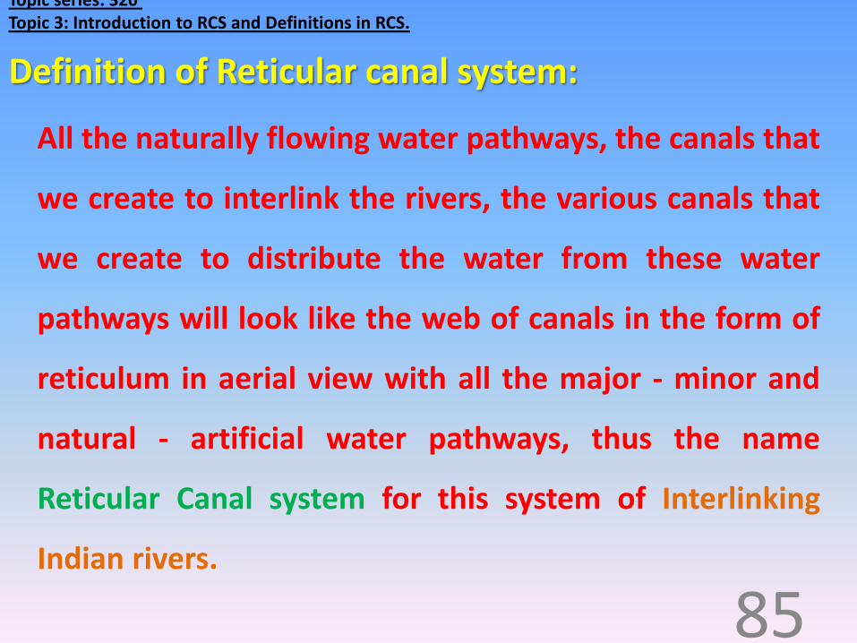
Topic series: 320 Topic 3: Introduction to RCS and Definitions in RCS.
RCS is like a bus, new passengers gets in and fewpassengers gets down from the bus.
83
RCS is like a post office; it receives letters from various postboxes and distributes it to various houses.
RCS is like a college, new batch of students enters thecollege and the students who completes the course goes outof the college,
RCS is like a bank, credit comes from one side and debitgoes on other side,
Topic series: 320 Topic 3: Introduction to RCS and Definitions in RCS.
All the naturally flowing water pathways, the canals that
we create to interlink the rivers, the various canals that
we create to distribute the water from these water
pathways will look like the web of canals in the form of
reticulum in aerial view with all the major - minor and
natural - artificial water pathways, thus the name
Reticular Canal system for this system of Interlinking
Indian rivers.
85
Definition of Reticular canal system:

Steps in creating RCS Map FPC river points eg: FPC1Cauvery500.
Map CRR (Canal reference line) eg: FPC1CRR500.
Map multiple CRR, eg: FPC1CRR475, FPC1CRR525.
Select the best CRR with more than 98% of plain canal possibility (Passes at the junction of forest and
agriculture land, passes less in the forest, does not crosses major cities, has good canal rim thus less
prone for damages like land slides – canal wall damage).
Map CRL (Canal reference land)of +/- 2meters of level for the be best CRR.
Identify the structures to be constructed like CE(Canal elevator) DCC (Direct Canal Connector), Aqua
ducts, U tubes, bi dams and so on.
Map the CL (Canal line) - sea side and hill side edge of the canal in the CRL with good hillside and sea
side rims.
Note all these are done in the RCS lab with the help of GPS based soft wares eg: Google earth, Bhuvan
of ISRO, or others.

•BIDIRECTIONAL FLOW BETWEEN ‘ARAVALLI – VINDYA’ IN NORTH TO ‘CARDOMOM HILLS’ IN THE SOUTH 500:
156
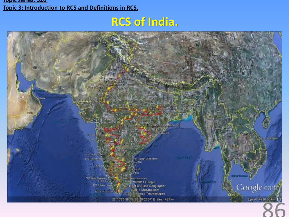
Topic series: 320 Topic 3: Introduction to RCS and Definitions in RCS.
RCS of India.
86

Suppliers of water to the RCS.
Now it is better to create the channel systems in such a way
that it utilizes the surface water to the maximum extent, so that
least water reaches the sea directly. 114
When we are creating RCS it is better to depend on the water
source that is continuous over all the 12 months, potable for
drinking, sufficient for irrigation and industry.
INDIA is blessed with plenty of rivers that are flowing all the 12
months, and most of the water is reaching the sea without any
useful utility, for example 70% of the water of GANGA RIVER
reaches the sea.

What Reticular canal system does?• Collecting the water: RCS assess the water generation in the river
basins and the flow, not only in the catchment area of the reservoirs of
the same river basin, but also ‘from’ and ‘to’, to all the river basins.
• Diverting the water: RCS will divert the water to all the possible places
at the higher level, before the water reaches the lower level.
• Distributing the water: RCS distributes water to all the rivers, lakes,
ponds, reservoirs, artificial canals and to all the places where ever we
want and when ever we want, when there is rain at any place which is
higher to the place of RCS canal / place of storage.

Rain and Reservoir.Rain and Reservoir:
• Scenario 1: Reservoirs are full
some times.
• Scenario 2: Reservoirs are
some what filled but not to
the extent of releasing the
water.
• Scenario 3: Reservoirs are
empty for many months in a
year.

Rain and Reservoirs: Lessons from the previous scenarios:
Excess water.
• All the water which generates in
one river basin cannot be stored
with any number of reservoirs,
• We need to leave the water to the
sea which exceed the capacity of
the reservoir/s.
• People will not have any benefit
out of the water which reaches the
sea.
Less water.
• Many reservoirs will remain empty
waiting for long time for the rain to
occur in its catchment area.
• Many reservoirs wait for the release
of water stored at another reservoir
even if the water which is present in
the reservoir is insufficient to
provide irrigation to the lands
depending on that reservoir.

Rain and Reservoirs: Lessons from the previous scenarios:
Process of raining.
• Water will not come and
fill the reservoir in a
fraction of seconds; rain is
not going to happen like a
flash.
• The raining is the process
it takes its own time, and
thus the flow of water in
its path.
Storage problems.
• Whatever number of reservoir system
we have today with their maximum
capacity is not sufficient for present
population.
• Disputes are present and the
tribunals to keep these ‘disputes for
decades’ exists because of demand
more than the availability of water in
one river basin.

Uses of RCS for ILR as compared to the other methods of ILR.
Sufficient in volume (TMC), thus Say no to ‘disputes’. 23
Simple in creation,
Surface in situation (so that, it is available for use all along the course), Safe, even if it breaks down (Imagine the difference between breaking the tank on one side and the pipe on the other side), Secure even in the absence of monitoring,
Synergistic to the present irrigation system,
Saves money in creation and maintainace still irrigates ‘larger Surface’.
Sustainable in long run in the Service of irrigating the land,

giving justice to
both. 24
RCS will act like a
‘bridge’
in a ‘reticular fashion’
between flood and drought prone area

Uses of RCS for ILR as compared to the other methods of ILR.
• It is possible to maintain the optimum level of water in
most of the reservoirs in all the seasons.
• FPC1CL500 will supply all the dams and the areas which
are below the level of 500mts AMSL (except in the states
of Jammu and Kashmir, North eastern states), the
principle feeders will be the Ganga and the Yamuna.

Uses of RCS for ILR as compared to the other methods of ILR.
• FPC2CL900 will supply all the dams and the
areas which are below the level of 900mts AMSL
in south Deccan platue especially the southern
districts of Karnataka, western districts of
Andhra Pradesh and Tamilnadu and the principle
feeders will be the River Kaveri.

Uses of RCS for ILR as compared to the other methods of ILR.
• Ganga upper canal and Yamuna Upper canal will
supply all the dams and the areas which are below
the level of 800mts AMSL in north Indian states
like Punjab, Haryana, Himachal Pradesh, Delhi,
northern district of Uttarpradesh, Bihar which are
north to the course of Ganga and Yamuna will get
the water from the RCS and the principle feeders
will be the Ganga and Yamuna Rivers.

Topic series: 320 Topic 3: Introduction to RCS and Definitions in RCS.
River elevator: It is the artificial structure created across the flow ofthe river to elevate the top flowing level of the river, to make the riverto flow down / at the same level, higher than the original level in thecourse we require.
91
Some terminologies we use in this system:

Topic series: 320 Topic 3: Introduction to RCS and Definitions in RCS.
River elevator: This is constructed across the river.
92
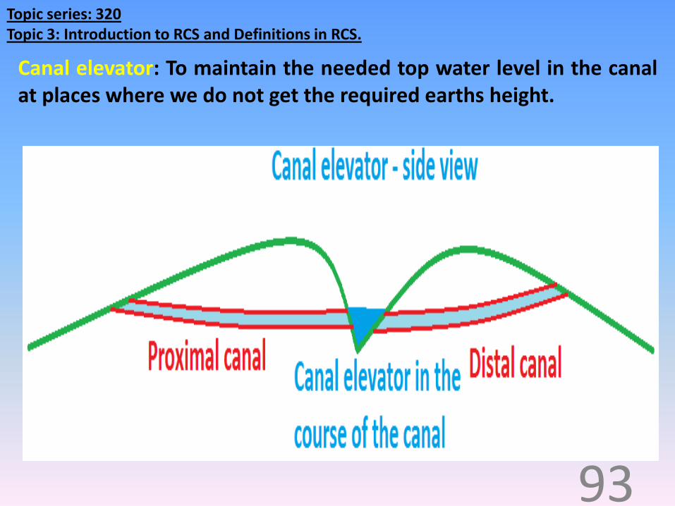
Topic series: 320 Topic 3: Introduction to RCS and Definitions in RCS.
Canal elevator: To maintain the needed top water level in the canalat places where we do not get the required earths height.
93

Topic series: 320 Topic 3: Introduction to RCS and Definitions in RCS.
Canal elevator: This is constructed along the course ofcanal on one side. It looks like a ‘node’ from the top.
94
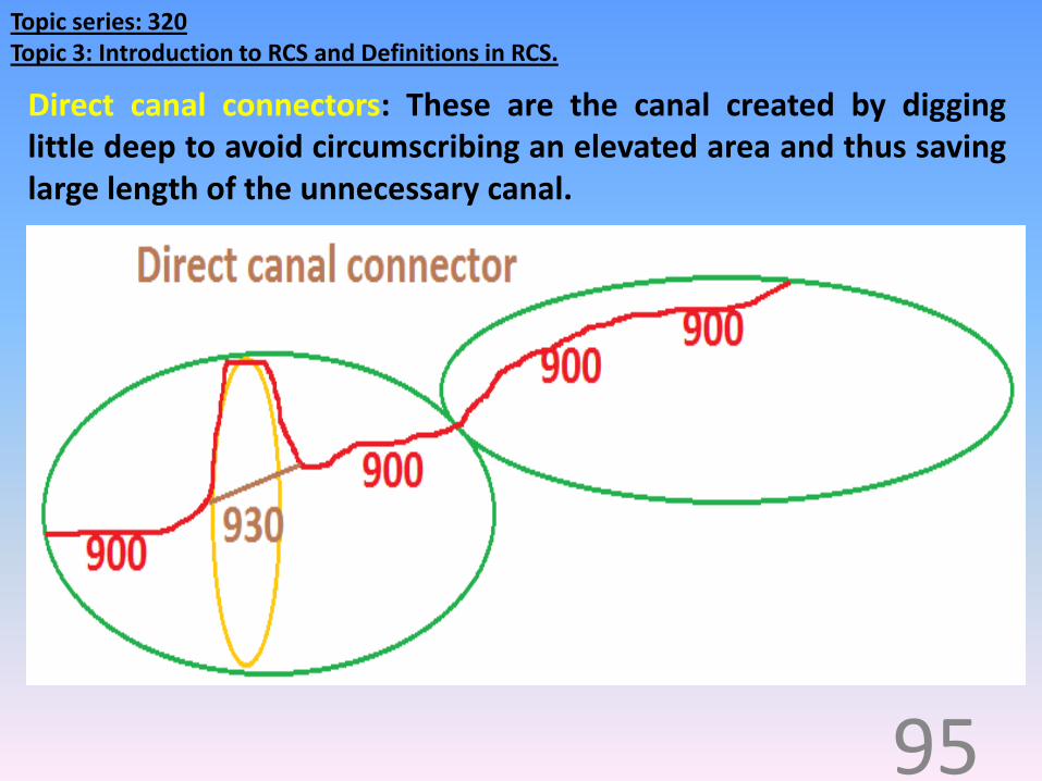
Topic series: 320 Topic 3: Introduction to RCS and Definitions in RCS.
Direct canal connectors: These are the canal created by digginglittle deep to avoid circumscribing an elevated area and thus savinglarge length of the unnecessary canal.
95

Topic series: 320 Topic 3: Introduction to RCS and Definitions in RCS.
U tube: This is a closed canal system in the shape of U with waterreceiving end at a higher level than the water discharging end thusthe water is going to flow from one end of the U tube to anotherend by Gravity.It is also possible to create the U tube with both the ends at thesame level expecting bi directional flow.
96

Topic series: 320 Topic 3: Introduction to RCS and Definitions in RCS.
Bi dam: (two dam) the wall like parallel structures constructedalong the course of the canal at places where we do not get therequired earths height. The parallel walls will be constructed oneither the sides of the future water flowing path.
97

Topic series: 320 Topic 3: Introduction to RCS and Definitions in RCS.
Bi dam - FPC1 start to Gambhir500-D1-431.
98

Topic series: 320 Topic 3: Introduction to RCS and Definitions in RCS.
Y Bi dam: Bi dam with the diversion path in the shape of Y.
99
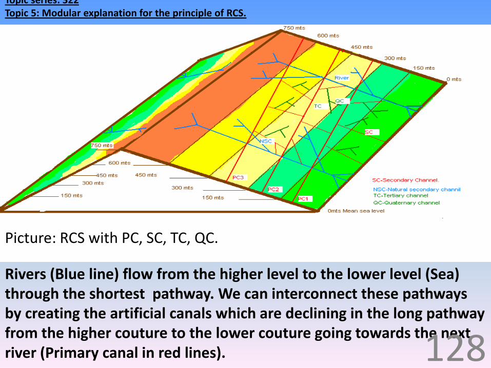
Topic series: 322Topic 5: Modular explanation for the principle of RCS.
Rivers (Blue line) flow from the higher level to the lower level (Sea) through the shortest pathway. We can interconnect these pathways by creating the artificial canals which are declining in the long pathway from the higher couture to the lower couture going towards the next river (Primary canal in red lines).
Picture: RCS with PC, SC, TC, QC.
128
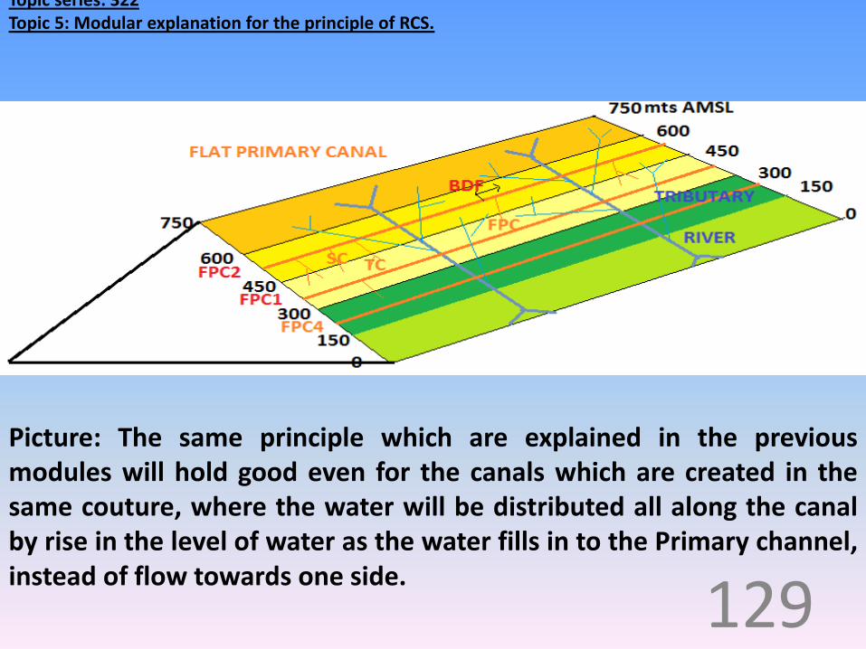
Topic series: 322Topic 5: Modular explanation for the principle of RCS.
Picture: The same principle which are explained in the previousmodules will hold good even for the canals which are created in thesame couture, where the water will be distributed all along the canalby rise in the level of water as the water fills in to the Primary channel,instead of flow towards one side.
129

Topic series: 322Topic 5: Modular explanation for the principle of RCS.
If we want to store the water, when there is a need, we can utilize the water of the RCS for filling the natural/ artificial reservoirs (blue and red dotted area respectively), dams, bounding and others.
Picture: We can store the water by utilizing the water of the RCS forfilling the natural/ artificial reservoirs.
131

Topic series: 320 Topic 3: Introduction to RCS and Definitions in RCS.
RCS of India.
86

•‘HIMALAYA’ TO ‘ARAVALLI – VINDYA’ SHIFT OF WATER 950 – 500.
155

•GANGA RIVER ELEVATOR 950:
157

5. GANGA UPPER CANAL 950 – 930:
158

6. GANGA U TUBE 930 – 870:
159

7. YAMUNA UPPER CANALL 870 – 830 – 800:
160

•YAMUNA U TUBE 800 – 700:
161

9. FLAT PRIMARY CANAL 1 – 500:
162

10. FLAT PRIMARY CANAL 2 – 900.
163

11. FLAT PRIMARY CHANNEL 4 RIVER POINTS WITH FPC 1 & 2:
164

Uses of Reticular canal system for ILR
What decreases?• Drought.• Flood.• Poverty.• Diseases related to
underground water (Poor chemical quality)
• Diseases related to surface water (Poor microbiological quality.
• Incidence of diseases.• Work absenteeism.• Hospitalization.• Expenditure.
What increases?• Water for domestic use.• Water for agriculture.• Water for Industry.• Raining.• Underground water level.• Electricity generation.• Agriculture production.• Better livelihood.• National progress.• Personnel economy.• Family economy.• National economy.• Nutrition.• Health.• Productivity.

Effects Drought and Poverty on:
Nation
27
PoorRich
Globe /Environment

Effects of drought and poverty on Poor:More number of poor - Nation becomes poor
What becomes less?
• Nutritional intake.
• Build.
• Health.
• Life span.
• Working capability.
• Quality of life.
• Competitiveness.
What becomes more?
• Diseases.
• Diseases reservoirs.
• Malnutrition.
• Burden on Government and charitable hospital.
• Expectation from the government for the support.
• Poverty transmission to the next generation.

Effects of drought and poverty on Rich:
What becomes less?
• Customers.
• Quality.
• Durability.
• Services.
• Rich becoming richer.
What becomes more?
• Quarrel while paying bills.
• Cheaper items.
• Gap between the rich and poor.
• Terrorism and naxalism.
• Crime.
• Theft.
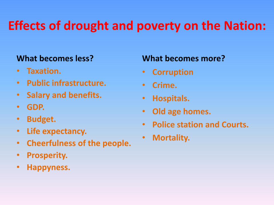
Effects of drought and poverty on the Nation:
What becomes less?
• Taxation.
• Public infrastructure.
• Salary and benefits.
• GDP.
• Budget.
• Life expectancy.
• Cheerfulness of the people.
• Prosperity.
• Happyness.
What becomes more?
• Corruption
• Crime.
• Hospitals.
• Old age homes.
• Police station and Courts.
• Mortality.

Effects of drought and poverty on Globe /Environment.
It is very much essential to eradicate poverty to save our planet.
Cheaper products - increased waste generation.
Low cost transportation vehicle - More emission.
Free / cheap / charitable hospitals - more demand than the supply -
people to become symptomatically better but may make them chronic
carrier or a morbid person with the brand of ‘no disease’.
Poor quality school -Live away from the school leads to ‘late to start
in education - less gain of knowledge and more dependency.

Effects of drought and poverty on Globe /Environment.
Unhygienic atmosphere – e.g. poor sanitary facility, open air defecation,
improper waste disposal - surface water contamination.
Over crowded house - communicable diseases.
less knowledge – more diseases more import of essentials materials /
equipments and medicines in large quantity for higher price - unaffordable for
the common person.
Sell their products in an unhygienic way - food born diseases.
Spry the insecticides any number of times to save their crop, thus makes the
food poisonous, this also leads to the land pollution.
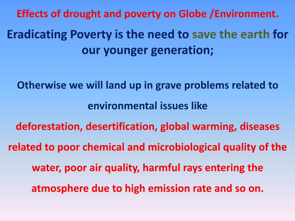
Effects of drought and poverty on Globe /Environment.
Eradicating Poverty is the need to save the earth for our younger generation;
Otherwise we will land up in grave problems related to
environmental issues like
deforestation, desertification, global warming, diseases
related to poor chemical and microbiological quality of the
water, poor air quality, harmful rays entering the
atmosphere due to high emission rate and so on.

Thanking youVISIT: www.slideshare.net/drshivu