METEOR Baseline Design Document Report Number: M2.3/P
38
METEOR Baseline Design Document Report Number: M2.3/P 14 September 2018 Contributors: C. Simon L. Petrarulo A. Lyon
Transcript of METEOR Baseline Design Document Report Number: M2.3/P

METEOR Baseline Design Document
Report Number: M2.3/P
14 September 2018
Contributors:
C. Simon
L. Petrarulo
A. Lyon

METEOR Baseline Design Document
i
Document Verification
Project METEOR: Modelling Exposure Through Earth Observation Routines
Report Title METEOR Baseline Design Document
Related Milestone M2.3
Reference as C. Simon, L. Petrarulo & A. Lyon (2018) METEOR Baseline Design Document. Report M2.3/P
Release Type Public / Confidential / Confidential with Embargo Period
Prepared by: Contributors
Work Package Leader:
L. Petrarulo
Signature(s):
Date(s):
14/09/2018
Approved by: Project Manager
Name:
K. Smith
Signature:
Date:
19/09/2018
Approved by: UKSA IPP Project Officer
Name:
Signature:
Date:
Date Version Alterations Editor

METEOR Baseline Design Document
ii
Contents
DOCUMENT VERIFICATION ............................................................................................................................... I
ACRONYMS ...................................................................................................................................................... 1
1. INTRODUCTION ....................................................................................................................................... 2
1.1. PROJECT SUMMARY .................................................................................................................................... 2
1.2. METEOR PROJECT OVERVIEW ..................................................................................................................... 2
2. BASELINE OBJECTIVES AND APPROACH ................................................................................................... 3
3. COUNTRY CASE STUDIES .......................................................................................................................... 4
3.1. SAMPLING ................................................................................................................................................ 4
3.2. DATA COLLECTION TOOLS ............................................................................................................................ 4
3.3. COUNTRY BASELINE EXECUTION PLANS ............................................................................................................ 7
4. GLOBAL STUDY ...................................................................................................................................... 11
4.1. SAMPLING .............................................................................................................................................. 11
4.2. DATA COLLECTION TOOLS ........................................................................................................................... 12
5. WORK PLAN – BASELINE ........................................................................................................................ 13
ANNEX A – ANNOTATIVE BIBLIOGRAPHY TEMPLATE ..................................................................................... 14
ANNEX B – METEOR KII GUIDE FOR: NATIONAL ACTORS ................................................................................ 16
ANNEX C – EXAMPLE OF EVALUATION WORKSHOP’S SLIDES ......................................................................... 21
ANNEX D – METEOR KII GUIDE FOR: HUMANITARIAN ORGANISATIONS ........................................................ 28
ANNEX E – METEOR KII GUIDE FOR: INSURANCE ORGANISATIONS ................................................................ 32
Figures
Figure 1: Example of evidence to ‘grade’ efforts towards achieving the result for Outcome 1 ............. 6
Figure 2: Baseline workplan .................................................................................................................. 13
Tables
Table 1: Key documents identified from baseline evaluation in Nepal .................................................. 7
Table 2: Initial stakeholders identified in Nepal ..................................................................................... 8
Table 3: Key documents identified from baseline evaluation in Tanzania ............................................. 9
Table 4: Initial stakeholders identified in Tanzania .............................................................................. 10
Table 5: Initial list of Global stakeholders ............................................................................................. 11

METEOR Baseline Design Document
Page 1
Acronyms
BGS The British Geological Survey
CAT Catastrophe
CEA Cost-Effectiveness Assessment
DfiD Department for International Development
DMD Disaster Management Department
DRM Disaster Risk Management
DRR Disaster Risk Reduction
EQ Evaluation Question
GEM The Global Earthquake Model
HOT The Humanitarian OpenStreetMap Team
IDF Insurance Development Forum
IPP International Partnership Programme
KII Key Informant Interview
KP Knowledge Product
KPI Key Performance Indicator
LDC Least Developed Country
M&E Monitoring & Evaluation
METEOR Modelling Exposure Through Earth Observation Routines
NGO Non-Governmental Organisation
NSET National Society for Earthquake Technology
ODA Official Development Aid
OPM Oxford Policy Management Limited
QA Quality Assurance
SDGs United Nations Sustainable Development Goals
ToC Theory of Change
UKSA United Kingdom Space Agency
UNICEF United Nations Children's Emergency Fund
UNISDR United Nations Office for Disaster Risk Reduction
WP2 Work Package 2 - M&E Activities

METEOR Baseline Design Document
Page 2
Introduction
1.1. Project Summary Project Title Modelling Exposure Through Earth Observation Routines (METEOR): EO-
based Exposure, Nepal and Tanzania
Starting Date 08/02/2018
Duration 36 months
Partners UK Partners: The British Geological Survey (BGS) (Lead), Oxford Policy Management Limited (OPM), SSBN Limited
International Partners: The Disaster Management Department, Office of the Prime Minister – Tanzania, The Global Earthquake Model (GEM) Foundation, The Humanitarian OpenStreetMap Team (HOT), ImageCat, National Society for Earthquake Technology (NSET) – Nepal
Target Countries Nepal and Tanzania for “level 2” results and all 47 Least Developed ODA countries for “level 1” data
IPP Project IPPC2_07_BGS_METEOR
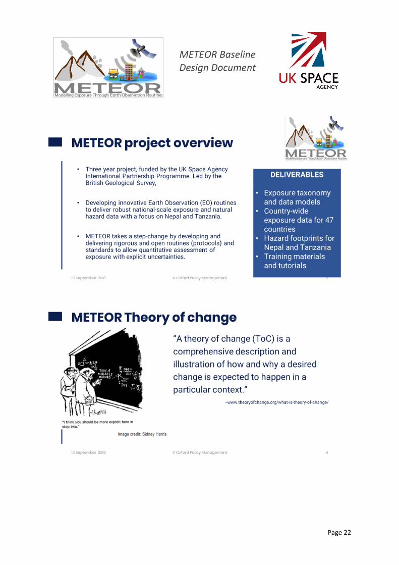
1.2. METEOR Project Overview At present, there is a poor understanding of population exposure in some ODA countries, which causes major challenges when making Disaster Risk Management decisions. METEOR (Modelling Exposure Through Earth Observation Routines) takes a step-change in the application of Earth Observation exposure data by developing and delivering more accurate levels of population exposure to natural hazards. Providing new consistent data to governments, town planners and insurance providers will promote welfare and economic development in these countries and better enable them to respond to the hazards when they do occur.
METEOR is funded through the second iterations of the UK Space Agency’s International Partnership Programme, which uses space expertise to deliver innovative solutions to real world problems across the globe. The funding helps to build sustainable development while building
effective partnerships that can lead to growth opportunities for British companies.
METEOR Baseline Design Document
Page 3
2. Baseline objectives and approach
The primary objective of the baseline evaluation is to ground the evaluation in a clear picture of the social, political, and economic context in which this project sits. This effort includes at the national level (i) describing the institutional framework which governs the use of exposure data in disaster risk management policy and planning in Nepal and Tanzania, the two pilot countries; (ii) assessing baseline levels of awareness, capacity and understanding around the concepts related to exposure, risk, vulnerability and disaster planning and response; and (iii) determining national stakeholder interest in the METEOR project. At the global level, the baseline will (i) identify public and private stakeholders internationally who have clear interests and influences on project objectives and goals; and (ii) determine their level of interest in the program. Finally, in the baseline we will calculate and/or set baseline values for indicators in the project logframe and determine appropriate targets to help measure longer-term success.
One challenge of the METEOR project is that several of the impact indicators (e.g. reductions in disaster related deaths and reductions in disaster related losses) are linked to the response in the event of a disaster. Since the project has no control over when and when a disaster may strike, it is impractical to plan for a household-level impact evaluation. As such, it was agreed upfront that the impact evaluation would focus on the measurable outcomes and impacts related to improvements in policies, plans, practice around DRR/DRM and increased usage and satisfaction in exposure, hazard, and vulnerability data. The contingent KPIs (or those that rely on a disaster unfolding within the timeframe of the project) will be tracked using official national statistics. Since the project is guided by a theory of change, we will use a theory-based approach and a variety of qualitative methods and tools to evaluate impact.
The baseline evaluation has two workstreams: country case studies and global study. The outputs of these two workstreams will be combined in a single METEOR Baseline Evaluation Report. A description of the steps for sampling, data collection, and analysis follow below.

METEOR Baseline Design Document
Page 4
3. Country case studies A team from OPM will work with national partners (NSET in Nepal, DMD in Tanzania) to conduct the baseline data collection. OPM will use a team approach where international evaluators will join local OPM M&E Officers in Tanzania and Nepal in targeted in-country missions to collect and analyse data. Data collection will consist of (i) a desk review of key national documents related to exposure, DRM, DRR, and response; (ii) a series of in-depth key informant interviews to assess in-country levels of awareness, understanding and capacity around these issues; (iv) an initial evaluation workshop with national partners to discuss the design of an initial rubric that can be used in subsequent workshops (at mid-term and end-line) to assess progress along the theory of change and METEOR’s contribution towards that progress. Each of these are described in more detail below.
3.1. Sampling The case studies will use a snowball sampling approach where initial stakeholders are identified by national partners and desk review materials and expands based on these stakeholders suggesting other key stakeholders to interview1. Since the sample expands as one speaks with stakeholders, the actual sample size will grow as the baseline is conducted. Indicatively, we expect 15-20 interviews in each country.
3.2. Data Collection Tools
3.2.1. Desk Review The desk reviews involve the identification and collection of national level documents related to the METEOR project. The approach to collecting these documents includes searching for:
1. Documents/research papers by our local partners. Look on partner websites. For example, NSET just hosted an International conference on Experience of Earthquake Risk Management, Preparedness and Reconstruction (see http://www.nset.org.np/nset2012/index.php/event/eventdetail/eventid-474)
2. Available government documents on disaster risk management. Often governments will publish risk management plans.
3. Government documents on in-countries hazards such as earthquakes for Nepal, Floods for Tanzania.
4. Evaluations/reports/assessments on disaster response for recent disasters in country. 5. Useful documentation on earth observation, remote sensing or exposure data related to the
country
The output of the desk review will be an annotative bibliography that lists the key documents identified and briefly describes what they contain (See ANNEX A). This information will then be used to feed into the final baseline report as well as a resource for identifying additional stakeholders.
1 Snowball sampling is a non-probability sampling approach that is frequently used in qualitative evaluations, in particular when not all the possible stakeholders are known upfront.
METEOR Baseline Design Document
Page 5
3.2.2. Key Informant Interviews The key informant interviews (KIIs) represent the bulk of the data collection effort in country and will be used to explore in greater depth how each actor currently fits into the larger exposure DRM environment (stakeholder mapping) as well as to gain their view on the current elements of the national and sub-national DRM systems. OPM follows strict ethics guidelines in KIIs, particularly around consent. This would include taking written consent via email and ensuring that the participant is clear on how the data will be used (e.g. purpose of the study, procedures for the study, confidentiality and anonymity) and that their participation is voluntary (i.e. that they have the right to refuse).
The national KII guide can be found in ANNEX B and includes the following areas of questions:
• Description of their organization and role
• Description on how disaster preparedness and planning functions in-country and how their organization fits into this picture;
• Understanding of how risk is assessed
• Perceptions on the key challenges their country faces when planning for and responding to a disaster;
• Assessment of level of awareness, understanding and use of key concepts related to exposure, DRM, and vulnerability;
• Use of different data sets in their work;
• Perceptions on what is needed to improve capacity of national actors in this space
The KII guide has been reviewed by the M&E team in collaboration with the rest of the METEOR partners. As it currently stands, the guide will be initially tested and refined during the baseline mission in Nepal (September 2018). An interim M&E team call during the initial part of the mission will review the initial running of the KIIs and assess the necessary changes to the guide.
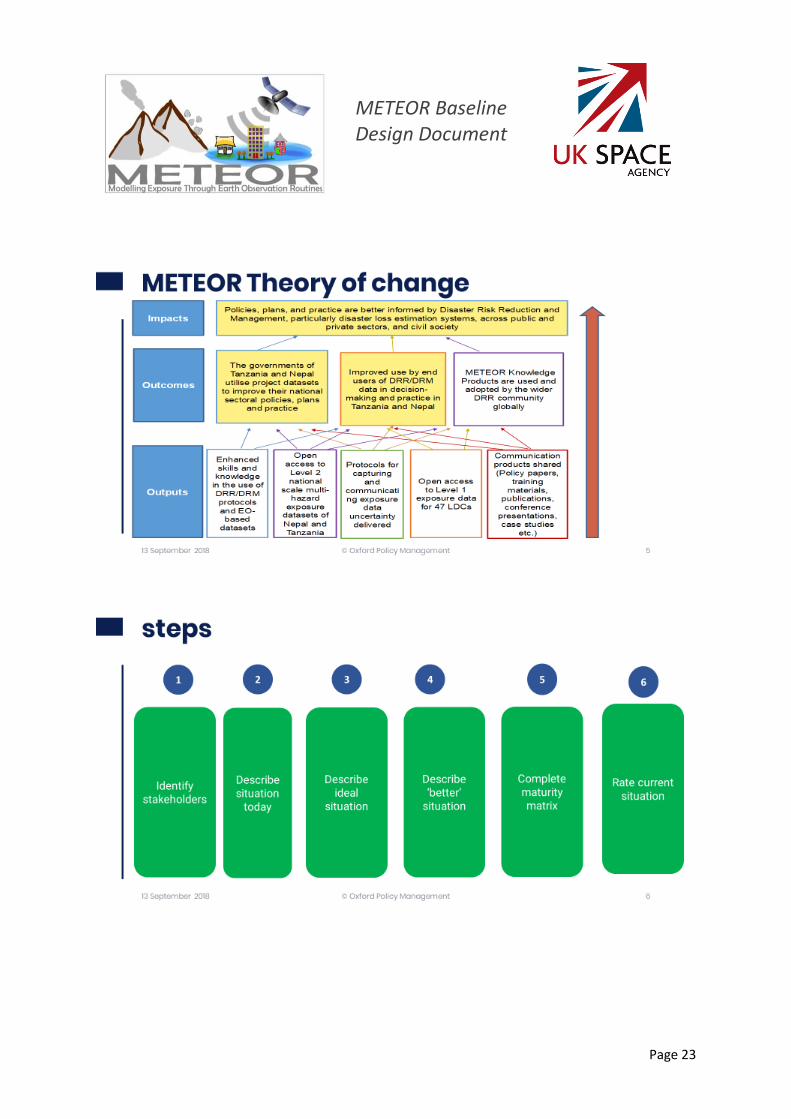
3.2.3. Evaluation Workshop Since the full set of project stakeholders will only be identified during the baseline data collection, the initial evaluation workshop will be more informal and will only include local partner staff. This initial workshop will involve the following:
• Reviewing METEOR ToC, indicators, and targets;
• Reviewing the evaluation questions;
• Discussing the design of a rubric that can be used in subsequent workshops (at mid-term and end-line) to assess progress along the theory of change and METEOR’s contribution towards progress
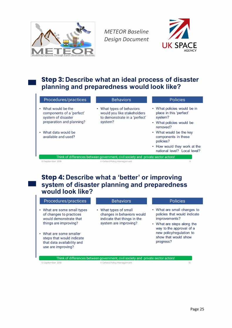
In the workshop, the team will establish a methodology for setting baseline values for qualitative indicators and for consistently assessing progress towards results. To do so, the OPM team will take local partners through an exercise where they discuss each result in the ToC (outputs, outcomes, and impacts) assessing where they are now, identifying what is planned for in the future (if known), and agreeing upon what would constitute forward progress in the medium and longer-term. Using this information, the team will establish baseline levels and finalize a rubric on how to measure progress in the mid and end-line evaluations. The below box presents an indicative example of how a rubric might work as extracted from the M&E Plan. See ANNEX C for example workshop slides.

METEOR Baseline Design Document
Page 6
Outcome #1 – “The governments of Tanzania and Nepal utilise project datasets to improve their national sectoral policies, plans and practice.” Sector representatives and other stakeholders will discuss activities that they have undertaken that demonstrate progress towards change. While in the early years policies may not have changed, there could be progress towards change such as meetings held on specific DRM/DRR topics, drafts policies circulated, public declarations, etc. demonstrating progress towards end goals. Once this information is gathered, the group will use it as evidence to ‘grade’ efforts towards achieving the result, using an agreed upon rubric. An example rubric is described in Figure 1. Please note this is just an example. The actual definition of the criteria and scoring will be discussed and agreed upon in the first workshop. Each year, at the conclusion of the workshop we will have ‘grades’ for each indictor and action steps for the coming year. In the following year, this progress will be reviewed and updated. The evidence gathered at these workshops will be the centrepiece of describing the contribution story.
Figure 1: Example of evidence to ‘grade’ efforts towards achieving the result for Outcome 1
Criteria Score
No progress has been made in any sector 0
Some discussions/activity but no substantive progress in any sector 1
Some progress made in 1-2 key areas 2
Substantive progress made in 1-2 key areas and some progress made in 1-2 other areas 3
Substantive progress in 3-4 key areas, including resourcing 4
Goals achieved in at least one area, substantive progress in other areas 5
Goals achieved in 2 or more areas 6
Criteria Evidence Score
OUTCOME 1: The governments of
Tanzania and Nepal utilise project
datasets to improve their national
sectoral policies, plans and practice
• Agriculture sector policy disseminated draft of
revised policy that includes more specific and
actionable DRR/DRM, including x,y,z.
• Office of the president announced increase in
National budget support for DRR/DRM
• Revised building code in the process of
development
• Remains weak enforcement of building codes
3

METEOR Baseline Design Document
Page 7
3.3. Country baseline execution plans 3.3.1. Nepal
For Nepal, the baseline evaluation will be conducted September 14-24, 2018. To date, key documents identified are included in Table 1.
Title Source organization
National Position Paper on Disaster Risk Reduction and Management Nepal
Ministry of Home Affairs, Government of Nepal, 2017
Nepal Disaster Report, 2017: The Road to Sendai Ministry of Home Affairs, Government of Nepal, 2018.
National Disaster Response Framework, Ministry of Home Affairs, Kathmandu, Nepal GON, 2013.,
National progress report on the implementation of the Hyogo Framework for Action (2013-2015).
HFA, 2015., Ministry of Home Affairs (MoHA) Nepal:
Disaster Risk Reduction in Nepal: Achievements, Challenges and Ways Forward,
National Planning Commission Paper for the AMCDRR 2016, MoHA
Disaster risk Reduction National Strategy Implementation Plan.
GON, Ministry of Home Affairs. 2018
Nepal Disaster Risk Reduction and Management Act.
GON, Ministry of Home Affairs, 2018.
Nepal Earthquake 2015: Post Disaster Needs Assessment: Key Findings. Vol. A.
Kathmandu: National Planning Commission, Government of Nepal.
Nepal Flood 2017: Post Flood Recovery Needs Assessment,
Kathmandu: National Planning Commission (NPC), Government of Nepal, (2017).
Nepal Earthquake 2015: Post-Disaster Recovery Framework, 2016-2020.
National Reconstruction Authority, Government of Nepal, (2016).
Rebuilding Nepal. NRA Newsletter. National Reconstruction Authority, Government of Nepal, (2017).
Nepal Post Disaster Reconstruction Experience: Current Status and Lessons Learned. A paper presented and discussed in SAWTEE Dialogue on Post Disaster Reconstruction
Pokharel, Jagadish C. (2017).
Disaster Risk Reduction, Climate Change Adaptation and Resilience.
Swiss NGO DRR Platform. (2016).
Table 1: Key documents identified from baseline evaluation in Nepal

METEOR Baseline Design Document
Page 8
The initial set of stakeholders include a variety of public and private institutions. This initial list includes those institutions provided by NSET, program partners, and through desk research (Table 2)
Type Institution Name
Government Central Bureau of Statistics
Department of Mines and Geology, Ministry of Industry, Commerce and Supplies
Department of Water Induced Disaster Management, Ministry of Irrigation
Department of Urban Development and Building Construction
National Emergency Operation Centre, Ministry of Home Affairs
Department of Survey (Ministry of Land Reform and Management)
Development Agencies DFID
JICA
DFAT
USAID
EU
Academia Institute of Engineering, Tribhuvan University
Central Department of Geography, Tribhuvan University
Department of Geology, Tribhuvan University
Institute of Engineering, Pulchowk, Tribhuvan University
TU Central Department of Environmental Science
Nepal Academy of Science and Technology
Civil Society Kathmandu Living Labs
The International Centre for Integrated Mountain Development
Red Cross Society
Action Aid – Nepal
Oxfam - Nepal
Private sector Genesis Consultancy (P) Ltd.
Table 2: Initial stakeholders identified in Nepal

METEOR Baseline Design Document
Page 9
3.3.2. Tanzania For Tanzania, the baseline evaluation will be conducted November 05-09, 2018. To date, key documents identified are include in Table 3.
Title Source organization
Disaster Management Act (2015 & 1990) Government of Tanzania
Disaster Management Regulations (2017) Government of Tanzania
Local Government Act (2006) Government of Tanzania
National Disaster Preparedness and Response Plan (2012)
Government of Tanzania
National Operational Guidelines for Disaster Risk Management (2014)
Government of Tanzania
National Security Council Act (2010) Government of Tanzania
Tanzania Urban Resilience Programme (TURP) Socioeconomic Vulnerability Study (2018)
Panman et al.
DarMAERT Emergency Response Plan Government of Tanzania
DISASTER RISKS AND CAPACITY NEEDS ASSESSMENT FOR TANZANIA MAINLAND (2008)
DMD
National Environment Statistics Report for Tanzania Mainland (NESR 2017)
National Bureau of Statistics
Africa Regional DRR Strategy (2004) African Union et al.
Dull Disasters? (2016) Clarke & Dercon
The East African Community DRR and DRM Bill (2013)
East Africa Community
UN Development Assistance Plan to Tanzania 2016-2021 (UNDAP II)
United Nations
Table 3: Key documents identified from baseline evaluation in Tanzania

METEOR Baseline Design Document
Page 10
The initial set of stakeholders include a variety of public and private institutions. This initial list includes those institutions provided by DMD, program partners, and through desk research (Table 4).
Type Institution Name
National government Tanzania Communication Regulatory Authority (TCRA)
Ministry of Works, Transport and Communication
Ministry of Lands, Housing and Human Settlements Development
Geological Survey of Tanzania
Ministry of Water and Irrigation
Tanzania Meteorological Agency (TMA)
Prime Minister’s Office – Disaster Management Department
Tanzania Disaster Relief Committee (TANDREC) / Tanzania Disaster Management Council- TMDC
Regional Disaster Management Committees
Vice President’s Office (VPO): Environment Division
National Bureau of Statistics
Tanzania Insurance Regulatory Authority (TIRA)
Local authorities Dar es Salaam Multi Agency Emergency Response Team (DarMAERT)
Academia Ardhi University
University of Dar es Salaam
Civil Society Tanzania Red Cross Society (TRCS)
Humanitarian Open StreetMap Team (HOT) Tanzania
Development Agencies DFID
World Bank
Private sector Main insurance companies
Table 4: Initial stakeholders identified in Tanzania
METEOR Baseline Design Document
Page 11
4. Global Study This workstream focuses on international stakeholders with a vested interest in METEOR outputs. Interviews with this stakeholder set will reveal key information about project relevance and sustainability, tracing overtime growing awareness, interest, and uptake of METEOR outputs outside the pilot countries.
4.1. Sampling The global study will use purposeful sampling, selecting key informants based on the knowledge, expertise, and experience of the consortium partners. These interviews will mostly be conducted by skype/phone. However, OPM team members plan to attend at a minimum one international conference on exposure/insurance/DRM where they will interview people in person. The target sample size for the global study is 7-10 interviews – five with international humanitarian organizations and five with insurance actors working in the space. An initial list of stakeholders is presented in Table 5.
Type Institution Name
Humanitarian Orgs UNICEF
UNISDR
World Bank Group
UNDP
European Commission
Insurance Orgs. Insurance Development Forum
AXA
Lloyd’s
Swiss Re
International Insurance Society
Munich Re
Aviva Global Insurance
AON Corporation
Table 5: Initial list of Global stakeholders
Possible conferences to attend include:
• American Geophysical Union fall meeting (Dec. 2018)
• Understanding Risk Conference (Mexico City, Mexico)
• Global Assessment Report (UNISDR) events (Geneva, Switzerland)
• World Conference of Earthquake Engineering (Sendai, Japan)
• Annual Risk Assessment workshops supported by GEM

METEOR Baseline Design Document
Page 12
• NSET 25th Anniversary, Risk2Resilience Conference (Kathmandu, Nepal)
• State of the Map 2018 conference (Milan, Italy)
• Global Platform on Disaster Risk Assessment (May 2019)
4.2. Data collection tools The baseline will focus on interviews with members of the humanitarian response community and the insurance industry and will involve a series of key informant interviews2. These two interview guides can be found in ANNEX D and ANNEX E respectively. Where possible, the questions are similar to those found in the national stakeholder interview guide. However, they also cover additional technical details. The topics covered are listed below.
Humanitarian organization interview guide:
• Description of their organization and role
• Perceptions on the key challenges LDC face when planning for and responding to a disaster;
• Assessment of familiarity to exposure data, how they use it in their work, and perceptions around the key challenges with using the existing data
• Interest in METEOR standards and protocols
• Perceptions on what is needed to improve capacity of LDC stakeholders in this space
Insurance industry interview guide:
• Description of their organization and role
• Perceptions on the key challenges LDC face when planning for and responding to a disaster;
• Description of the insurance/financial products organization is working on in LDCs
• Challenges designing and selling insurance/financial products to LDCs
• Challenges of existing exposure, vulnerability, and hazard datasets
• Interest in METEOR standards and protocols
• Perceptions on what is needed to improve capacity of LDC stakeholders in this space
2 The M&E plan references an on-line survey. After some internal discussion, the team determined that this survey should be directed at policy-makers from other ODA countries so as to track broader awareness and interest in METEOR products. Since, the project is just getting started, there will be little awareness of METEOR outside of our lighthouse countries. As such, the online survey will only happen at the end-line evaluation.

METEOR Baseline Design Document
Page 13
5. Work plan – Baseline
Figure 2: Baseline workplan
Milestone / Deliverable
In-country activity
Activity
Project month 1 2 3 4 5 6 7 8 9 10 11 12
Calendar month
Mar-
18
Ap
r-18
May-1
8
Ju
n-1
8
Ju
l-18
Au
g-1
8
Sep
-18
Oct-
18
No
v-1
8
Dec-1
8
Jan
-19
Feb
-19
Baseline evaluaiton
Desk review
Stakeholder mapping
Baseline missions preparation
Baseline missions (incl. participatory workshop)
Baseline data collection - National Case Studies
Baseline data collection - Global Case Study
Baseline Report preparation
Final Baseline Evaluation Report

METEOR Baseline Design Document
Page 14
ANNEX A
Annotative bibliography template
Index of Articles
In a folder, save each article in numerical order using the following convention: #_Lead Author Last Name_Article Title. So that they will look like this in the folder: 01_Simon_shortened version of title 02_Regmi_ shortened version of title Then enter the information into this table to serve as a listing of the articles we have collected
# Lead Author (last name, first name)
Date of article
Article Title
01
02
03
04
05
06
07
What to look for:
1. Documents/research papers by our local partners. Look on their websites. For example, NSET just hosted an International conference on Experience of Earthquake Risk Management, Preparedness and Reconstruction (see http://www.nset.org.np/nset2012/index.php/event/eventdetail/eventid-474)
2. Any available government documents on disaster risk management. Often times government will publish risk management plan.
3. Any government documents on in-countries hazards such as earthquakes for Nepal, Floods for Tanzania.
4. Any evaluations/reports on disaster response for recent disasters in country. 5. Any useful documentation on earth observation and remote sensing data – I wonder if our
partners at GEM or ImageCat could provide some useful basic documents on the technology and the issues.

METEOR Baseline Design Document
Page 15
METEOR ANNOTATED BIBLIOGRAPHY
In this table, make sure the numbers line up to those in the index. Then, including the full citation (as if it was going to go into a bibliography for an article) and then a brief description of the content of the article/document and a summary of what you think are the key points – in particular those that relate to the METEOR project.
# Full citation (authors, date, title, publisher,)
Brief description of content and key points – try to use bullet points.
• Overview:

METEOR Baseline Design Document
Page 16
ANNEX B METEOR KII GUIDE FOR: NATIONAL ACTORS
PREPARATION
Country:
Name of Interviewee Title/Role:
Name of
Organization:
Date of interview:
Name of interviewer Name of Note-
taker
INTRODUCTIONS
Introduce yourself and inform the respondents about the background of the study and why you are there. Ensure you have their consent to proceed with the interview. Let them know that the interview will take about 1-hour and that their responses will be anonymous. They can stop anytime if not comfortable with a question. Here is some suggested text:
Good morning/afternoon/evening. My name is [………………] from Oxford Policy Management. OPM is working with a consortium of organizations led by the British Geological Society on a project called Modelling Exposure Through Earth Observation Routines or METEOR. METEOR is a three-year project funded by the UK Space Agency to develop new ways of using space-related technologies such as Earth Observation (EO) techniques - particularly satellites - to improve understanding of exposure. Exposure in this context means the location and key characteristics infrastructure such as housing, factories, hospitals, and roads in an area that could be impacted or destroyed by a hazard such as an earthquake or a flood. The primary objective of the project is to develop rigorous and open-source standards and protocols that allow for the quantitative assessment of exposure in a multi-hazard setting. The goal is to help improve the ownership and use of exposure data by national stakeholders who can apply this information for use in disaster risk management and response activities. The project will also work closely with the insurance industry to help support the development of better-informed disaster risk insurance products in ODA countries.
We were given your name from our local partners [NSET or DMD] as a person who is actively engaged in this area. We would like to ask you a few questions about what you do and your activities around exposure, disaster risk management and response. The interview will take about one hour. The information you give us is confidential and will only be used for reporting purposes. Your name will not be revealed to anyone and your responses will be combined with others to show combined views and opinions. There are no right or wrong answers. It is your true opinion that is important to us.

METEOR Baseline Design Document
Page 17
DISCUSSION TOPICS
I want to start by getting a better understanding of your organization and your role.
1. Can you talk a little about [insert name of organization] and how it is structured?
What is its primary mission/objectives? (stakeholder mapping)
2. What is your role in the organization?
3. Can you briefly describe the in-country procedures/processes/policies the
government and other stakeholders undertake around disaster preparedness and
planning? Is your organization involved? What other organizations are involved?
PROBE here for working groups, regular meetings they have each year, programs or
initiatives with supporting documents, regular documents that are produced or reviewed?
How all of these efforts are financed? (Impact 1.2 and outcomes 2.1 and 3.1)
4. Can you talk about the most recent disaster [insert name of disaster] and describe
the types of procedures/processes the government and other stakeholders
undertook in the response? Is your organization involved? What other
organizations are involved? PROBE here for task forces? Who has authority to
determine disaster? How government, private sector and civil society work together? If
they work together? Who are the various agencies involved and their respective roles?
Probe to get the names of documents/laws/policies, etc. (Impact 1.2 and outcomes 2.1
and 3.1)

METEOR Baseline Design Document
Page 18
5. Are you familiar with the process of assessing the risks of a disaster? If yes, can
you describe in more detail what data or information is used to assess risk? What
types of models are used? Where the information comes from? Who is involved?
6. In your opinion, what are the major challenges facing [Nepal/Tanzania] when it
comes to planning for and responding to a disaster?
7. I am now going to ask you about a series of words/concepts related to planning
and responding to a disaster. For each concept I will ask you to describe what the
concept means to you and briefly discuss if or how you use this concept in your
work. Review the rating scale before proceeding. (impact indicator 3, outcome indicators
outcome 1.1 and 2.1)
Interview rate level of understanding 0 = Does not a clear idea of the concept 1 = familiar with the term; and can provide a definition 2= very familiar with the term and use it regularly in their work
1. What the terms means to the
stakeholder
2. If/how the stakeholder uses
this concept in their work
Concept Rating
Disaster Risk Reduction (DRR)
Vulnerability
Exposure (data)
Hazard
Risk
Loss estimation models
Uncertainty (in terms of disaster risk)

METEOR Baseline Design Document
Page 19
8. ONLY FOR THOSE THAT DO RISK ASSESSMENT IN THEIR WORK: What kind of
data and information do you use to assess exposure and disaster risk in your
work? How do you access these datasets? Where do they come from? What are
the challenges in using these data sets? How can we improve these data sets to
make better use of them in emergencies? What kind of additional skills training
would you like to see within your organization around data? (Outcome 2.2)
9. ONLY FOR NON-TECHNOCRATS THAT DON’T USE DATA SETS: What type of
data/information do you use in your work? How do you access this information?
Where does it come from? What, if any, are the challenges of the information?
(Outcome 2.2)
10. In your opinion, what is needed to improve the effectiveness DRM/DRR efforts
within government, civil society and the private sector? PROBE: What would you
use the finances for? training/education, risk awareness and communication activities,
etc. (outcome 1.2 and impact 3)
Thank the person you are interviewing for their time and ask whether the respondent
has any questions for you.

METEOR Baseline Design Document
Page 20
FOR THE NOTETAKER AND INTERVIEWER
After the interview, in this area, please enter any other interesting information about the interview. For example, do you think the group was being open? Were they holding anything back?

METEOR Baseline Design Document
Page 21
ANNEX C Example of evaluation workshop’s slides
METEOR Baseline Design Document
Page 22
METEOR Baseline Design Document
Page 23

METEOR Baseline Design Document
Page 24
METEOR Baseline Design Document
Page 25

METEOR Baseline Design Document
Page 26

METEOR Baseline Design Document
Page 27

METEOR Baseline Design Document
Page 28
ANNEX D METEOR KII GUIDE FOR: HUMANITARIAN ORGANISATIONS
PREPARATION
Country:
Name of Interviewee Title/Role:
Name of
Organization:
Date of interview:
Name of interviewer Name of Note-
taker
INTRODUCTIONS
Introduce yourself and inform the respondents about the background of the study and why you are there. Ensure you have their consent to proceed with the interview. Let them know that the interview will take about 1-hour and that their responses will be anonymous. They can stop anytime if not comfortable with a question. Here is some suggested text:
Good morning/afternoon/evening. My name is [………………] from Oxford Policy Management. OPM is working with a consortium of organizations led by the British Geological Society on a project called Modelling Exposure Through Earth Observation Routines or METEOR. METEOR is a three-year project funded by the UK Space Agency to develop new ways of using space-related technologies such as Earth Observation (EO) techniques - particularly satellites - to improve understanding of exposure. Exposure in this context means the location and key characteristics of people and infrastructure such as housing, factories, hospitals, and roads in an area that could be impacted or destroyed by a hazard such as an earthquake or a flood. The primary objective of the project is to develop rigorous and open-source standards and protocols that allow for the quantitative assessment of exposure in a multi-hazard setting. The goal is to help improve the ownership and use of exposure data by national stakeholders who can apply this information for use in disaster risk management and response activities. The project will also work closely with the insurance industry to help support the development of better-informed disaster risk insurance products in ODA countries.
We would like to ask you a few questions about what you do and your activities around exposure analysis and disaster risk management and response. The interview will take about one hour. The information you give us is confidential and will only be used for reporting purposes. Your name will not be revealed to anyone and your responses will be combined with others to show combined views and opinions. There are no right or wrong answers. It is your true opinion that is important to us.

METEOR Baseline Design Document
Page 29
DISCUSSION TOPICS
I want to start by getting a better understanding of your organization and your role.
1. Can you talk a little about [insert name of organization] and how it is structured?
What is its primary mission/objectives?
2. What is your role in the organization?
3. In your opinion, what are the major challenges facing less developed countries
when it comes to improving DRM/DRR and disaster response?
METEOR Baseline Design Document
Page 30
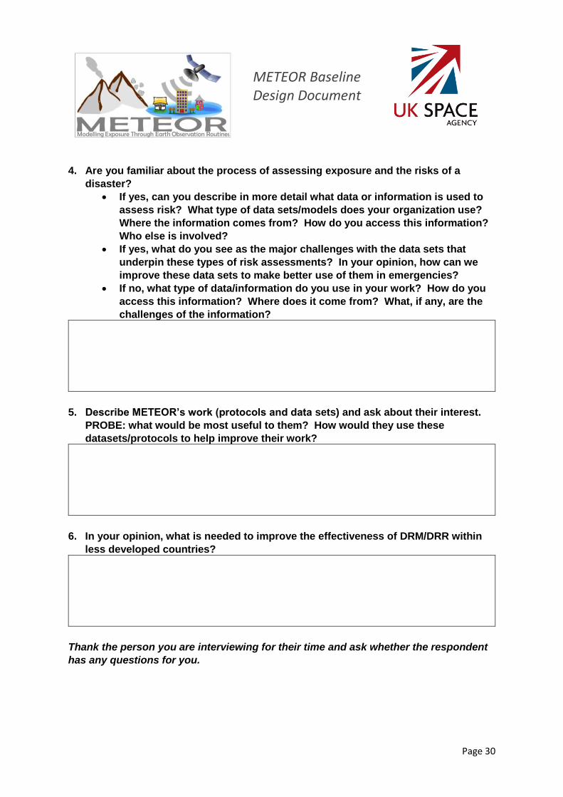
4. Are you familiar about the process of assessing exposure and the risks of a
disaster?
• If yes, can you describe in more detail what data or information is used to
assess risk? What type of data sets/models does your organization use?
Where the information comes from? How do you access this information?
Who else is involved?
• If yes, what do you see as the major challenges with the data sets that
underpin these types of risk assessments? In your opinion, how can we
improve these data sets to make better use of them in emergencies?
• If no, what type of data/information do you use in your work? How do you
access this information? Where does it come from? What, if any, are the
challenges of the information?
5. Describe METEOR’s work (protocols and data sets) and ask about their interest.
PROBE: what would be most useful to them? How would they use these
datasets/protocols to help improve their work?
6. In your opinion, what is needed to improve the effectiveness of DRM/DRR within
less developed countries?
Thank the person you are interviewing for their time and ask whether the respondent
has any questions for you.

METEOR Baseline Design Document
Page 31
FOR THE NOTETAKER AND INTERVIEWER
After the interview, in this area, please enter any other interesting information about the interview. For example, do you think the group was being open? Were they holding anything back?
METEOR Baseline Design Document
Page 32
ANNEX E METEOR KII GUIDE FOR: INSURANCE ORGANISATIONS
PREPARATION
Country:
Name of Interviewee Title/Role:
Name of
Organization:
Date of interview:
Name of interviewer Name of Note-
taker
INTRODUCTIONS
Introduce yourself and inform the respondents about the background of the study and why you are there. Ensure you have their consent to proceed with the interview. Let them know that the interview will take about 1-hour and that their responses will be anonymous. They can stop anytime if not comfortable with a question. Here is some suggested text:
Good morning/afternoon/evening. My name is [………………] from Oxford Policy Management. OPM is working with a consortium of organizations led by the British Geological Society on a project called Modelling Exposure Through Earth Observation Routines or METEOR. METEOR is a three-year project funded by the UK Space Agency to develop new ways of using space-related technologies such as Earth Observation (EO) techniques - particularly satellites - to improve understanding of exposure. Exposure in this context means the location and key characteristics of people and infrastructure such as housing, factories, hospitals, and roads in an area that could be impacted or destroyed by a hazard such as an earthquake or a flood. The primary objective of the project is to develop rigorous and open-source standards and protocols that allow for the quantitative assessment of exposure in a multi-hazard setting. The goal is to help improve the ownership and use of exposure data by national stakeholders who can apply this information for use in disaster risk management and response activities. The project will also work closely with the insurance industry to help support the development of better-informed disaster risk insurance products in ODA countries.
We would like to ask you a few questions about what you do and your activities around the use of exposure data in the design and development of insurance products for ODA countries. The interview will take about one hour. The information you give us is confidential and will only be used for reporting purposes. Your name will not be revealed to anyone and your responses will be combined with others to show combined views and opinions. There are no right or wrong answers. It is your true opinion that is important to us.

METEOR Baseline Design Document
Page 33
DISCUSSION TOPICS
I want to start by getting a better understanding of your organization and your role.
1. Can you talk a little about [insert name of organization] and how it is structured?
What is its primary mission/objectives?
2. What is your role in the organization?
3. In your opinion, what are the major challenges facing less developed countries
when it comes to improving DRM/DRR and disaster response?
4. Can you talk to me a bit more about any insurance or financial products your
organization is working on related to disaster risk management and focused on
LDCs? Do you know of any insurance and or financial products that others are
working on in this area?

METEOR Baseline Design Document
Page 34
5. What are the major challenges/issues you see when it comes to designing and
selling insurance products or other financial products for disaster risk
management, in less developed countries?
6. What do you see as the major challenges with the data sets that underpin these
types of insurance products or other financial products? In your opinion, how can
we improve these data sets to make better use of them in emergencies?
7. Describe METEOR’s work (protocols and data sets) and ask about their interest.
PROBE: what would be most useful to them? How would they use these
datasets/protocols to help improve their work?
8. In your opinion, what is needed to improve the effectiveness of DRM/DRR within
less developed countries?
Thank the person you are interviewing for their time and ask whether the respondent
has any questions for you.

METEOR Baseline Design Document
Page 35
FOR THE NOTETAKER AND INTERVIEWER
After the interview, in this area, please enter any other interesting information about the interview. For example, do you think the group was being open? Were they holding anything back?