MERIT REVIEW DOSSIER - UCANR
35
MERIT REVIEW DOSSIER University of California Cooperative Extension, Agriculture and Natural Resources
Transcript of MERIT REVIEW DOSSIER - UCANR

MERIT REVIEW DOSSIER
University of California Cooperative Extension,
Agriculture and Natural Resources

Program Summary Narrative Statement of Assignment
Program Area Condition Change % FTE
Forest & Rangeland Systems
Improved management and use of land 65%
Increased preparedness and resilience to extreme weather and climate change
10%
Positive Youth Development Increased workforce retention and competency 25%
Introduction
This program summary represents the review period from May 2016 to September 2019. This dossier provides evidence of my programmatic efforts commensurate with those expected of an Assistant Advisor Step III.
As the Forestry and Natural Resources Advisor in Shasta, Trinity and Siskiyou counties, I have identified my clientele groups as private forest landowners, professional forest practitioners, agencies and rural householders. My area of responsibility includes 5.3 million acres of federally owned forestland and one million acres of private industrial forests. Nonindustrial private forests with a median parcel size of less than 100 acres comprise the remaining 500,000 acres. Dimensional lumber is the primary forest commodity, with bioenergy generation supplementing the economic disposal of forest residues. To address the fragmented ownership structure between and within these clientele groups, my program works towards building climate-resilient forest communities and ecosystems as reflected in Goal 5 of UCANR’s Strategic Plan through delivery of best management practices.
I began my career at UCANR with a formal needs assessment of forest landowner and practitioner clientele. 640 surveys were mailed with a self-addressed return envelope. Mailings were followed by an email distribution to landowner and forest professional groups. 15% of surveyed clientele responded to the formal survey. Overall, clientele identified timber production as the most valuable benefit and wildfire as the greatest threat to forest systems. The forest practitioner clientele further ranked the loss of technical capacity as a major threat to sustaining healthy forests. These findings were verified with informal interviews among key industry and landowner groups, which are periodically reviewed. Through these discussions, I gained valuable perspective into the needs of my forest communities in Shasta, Trinity and Siskiyou which have in turn defined my core program themes.
1. Forest and Natural Resources Management2. Capacity Development3. Enhancing Community Understanding and Engagement
During this period, I have collaborated with various partners on 3 funded projects involving climate-adaptation, technical professional training, and wood products. These have resulted in 4 training manuals and numerous technical consultations. During this time, I have held 21 public meetings and workshops reaching over 968 clientele.

Theme #1: Forestry and Natural Resources Management
Background, Rationale and Problem
Forests throughout California are accumulating fuels at rates exceeding our future ability to manage. Meanwhile, a century of fire suppression has increased forest stress and set the stage for recent large-scale drought, bark beetle and wildfire mortality outbreaks. Efforts to facilitate the removal of these forest hazards have exposed the management challenges caused by insufficient wood processing capacity throughout the state. In Shasta, Trinity and Siskiyou, diseased and fire killed wood has saturated existing market demand and are displacing forest products that would otherwise fund routine forest improvement activity. Private non-industrial forests are particularly at risk due to economies of scale and insufficient knowledge transfer during ownership transition. Local forests established in the 1970s are now owned by a new generation of absentee landowners and exhibit heightened fuel loading, suppressed growth and extreme susceptibility to pathogens. This issue is further compounded by altered wildfire regimes, loss of forest practitioners and uncertain impact of climate change on future mortality. Supporting forest landowner and manager efforts with regionally relevant and objective information is essential for the persistence and economic sustainability of local forests.
Methods, Outcomes and Impacts
During this review period, my program has focused on developing best forest management practices and providing technical assistance to forest landowners and UCCE colleagues through facilitated research, workshops, invited presentations, individual site visits and educational field tours.
Sierra Nevada Adaptive Management Experiment: Under current California Forest Practice Rules, harvesting activity is limited to a legislatively defined set of practices. Established in 1973, these practices have not stayed current with increasing costs of operation and risk factors associated with wildfire. To combat this impending collapse of forests throughout California, I have collaborated with the University of Nevada Reno Silviculture Lab (UNR), US Forest Service (USFS), Blodgett Forest Research Station, UCCE Specialists and the California Department of Forestry and Fire Protection (CalFire) to develop a series of experimental forest treatments that will help landowner clientele improve forest health while reducing management and reforestation costs.
Outcome: As co-PI, I assisted the establishment of a $2.8m multi-year study evaluating new silvicultural approaches that improve forest resilience against potential climate change impacts. In addition to establishing partnerships with federal and state landowners, I designed and installed the northern replicate of this statewide project. My efforts with CalFire, USFS, UC Berkeley, UCCE and UNR have resulted in over 1,500 acres of treated forestland. adaptive-forest-management-experiment.com
Wood Products Infrastructure: The key obstacle to economically sustainable forest management stem from the loss of market capacity and revenue in the forest products market. Nationally and at the statewide level, multiple agencies seek to combat this issue by catalyzing development in areas with high potential for market growth.
Outcome: As PI, I established a $88,000 agreement to monitor and analyze California wood products demand and processing capacity. These data are provided in a web map interface to support agency and professional forester clientele with planning future infrastructure projects. In addition to collaborating with UCCE Advisors (Tompkins, Valachovic) on delivery of educational field trainings for UCCE and Agency staff, I negotiated a multi-location agreement with UC Berkeley to fund a Policy Analyst. As PI, I regularly provide technical consultation to CalFire’s Forest Resource Assessment Program (FRAP), the USFS Forest Inventory and Analysis program, University of Montana, and the

Governor’s Office. This multi-year collaboration with the USFS and FRAP defines UC’s commitment to sustainable use of wood resources in the state. ucanr.edu/woodmap
Theme #2: Capacity Development
Background, Rationale and Problem
Loss of technical expertise is one of the largest threats to maintaining healthy forest systems. With an aging workforce and declining recruitment, forest practitioners are under increasing pressure to manage larger landscape areas while complying with increasingly complex suites of objectives and regulations. Furthermore, the growing dominance of outside contracting in private and federal land planning has severely reduced training opportunities for upcoming practitioners. A 2018 survey conducted by Shasta College found that over 40% of natural resource industries experience workforce shortages in Shasta, Trinity and Siskiyou counties. Survey respondents reported key skill gaps in map reading, computer literacy and GIS. Educating current and emerging forest practitioners is therefore essential for the continued management of healthy forests.
Methods, Outcomes and Impacts
During this review period, I provided technical assistance and hosted workshops to enhance adoption and understanding of novel forest technologies while cultivating interest in natural resource careers among youth groups [see also theme 3].
GIS Technical Training: Traditionally, geospatial analysis in forest planning has been siloed to select individuals responsible for the analysis needs of an entire organization. This isolation results in an information bottleneck that impedes the ability to perform work efficiently and restricts opportunities for collaboration. Siloing in natural resource management also creates barriers to entry which dissuade technology-averse practitioners from collaborating with more technology dependent cohorts.
Outcome: As PI, I designed and implemented 6 technical Geospatial Information System (GIS) trainings across California. With support from a $13,500 RREA grant, I collaborated with UCCE Forest Advisors, Shasta College, Santa Rosa Junior College, Humboldt State University, UC Berkeley, Lake Tahoe Community College, and UCCE Informatics and GIS (IGIS) to reach 136 forest professionals. These workshops transitioned existing practitioners to newer cartographic tools while providing a base level of understanding to novel users. In addition to establishing UCCE’s availability as a technical resource for land managers, this workshop led to the successful employment of at least one workshop participant and adoption of current technology by 4 local consulting firms. A 4-part technical training manual was also developed that has since been incorporated into the curriculum at UC Berkeley, College of the Redwoods, Santa Rosa Junior College and Humboldt State University. Most critically, positive reception of this workshop has led to requests for training from the USFS and CalFire to address critical gaps in technical ability.
Pond Calculation: Recent regulatory changes under SB588 mandate landowners report changes in stored volumes. Depth-capacity curves used to track changes traditionally require a consultant or engineer to develop at great cost to the landowner.
Outcome: Utilizing new advances in technology, I collaborated with UCCE Advisors and Specialists (Forero, Bali, Zaccaria, Fulton, Davy) to develop a web-based application allowing landowners to build custom depth-capacity curves. Strategically designed to use widely available smartphone technology, this tool is accessible to users of all levels and demonstrates a novel outreach tool for UCCE to support

our communities. A user manual for this tool was published in the Northern California Ranch Update to reach 400 users. ucanr-igis.shinyapps.io/PondCalc
Youth Education : Forest practitioner attrition is a commonplace challenge due to the high cost of living and regulatory standard expected of professionals in California. From 2005 to 2019, the number of RPFs in California steadily declined from 1,334 to 1,126 despite ongoing market recovery and growing demand for projects on the ground. To meet this challenge, I collaborate extensively with youth programs and recent graduates to cultivate an interest in forestry careers.
Outcome: I regularly judge and train high school students at the California Forestry Challenge, introducing the application of basic forestry concepts found in typical forestry professions. I also work with current natural resources undergraduates and emerging forest practitioners through formal field trainings with various partners including the USFS, CalFire, UC Berkeley, Shasta College and UNR. These efforts provide informal opportunities for students to learn about the forest management industry while building relationships with potential future employers.
Theme #3: Enhancing Community Understanding and Engagement
Background, Rationale and Problem
Public discourse over how forests should be managed improves social equity but can also present obstacles to effective forest management. The National Environmental Policy Act and California Environmental Quality Act include provisions for stakeholder input during any forest planning process. Discussions with local agencies have revealed that while this involvement benefits sensitive species and watershed interests, they often create unintended obstacles that delay or reduce forest health improvement impact. Furthermore, the increasing pace and scale of wildfire has broadened public interest to consider the role of forest management in carbon storage and climate change. Due to the competing nature between reduced hazardous fuel volume and increasing carbon storage, there can be disagreement despite common ideals for improved forest health. To help the interested public better understand forest management decisions and activities, education programming must respond to current interests.
Methods, Outcomes and Impacts
During this reporting period, I provided workshops and technical documentation to support informed community efforts surrounding forest management, home design, forest fuel reduction and reintroduction of natural fire. Key to this effort is the education of engaged stakeholders to enhance their understanding of best management practices and balancing conflicting goals.
Statewide Fire Information Center: With increasing public attention on forest wildfire from successive wildfires impacting urban centers, the volume of information from unverified sources have rapidly overtaken the social media space. In contrast, UC’s prolific production of peer-reviewed wildfire information is underutilized due to a combination of poor marketing and disjointed coordination of the resources available. In the last decade alone, UCCE has developed and retired over ten separate resource centers with valuable fire information.
Outcome: I led an effort between the Center for Fire Research and Outreach, UC Berkeley Land Use Change Lab, UCCE Fire Workgroup, UC Forest Products Laboratory, UCANR Communication Services (CSIT) and various county extension advisors to update all UC resources regarding fire in natural and Wildland Urban Interface areas. Outdated resources were removed and consolidated into a new central

data center to provide agency partners, the public and UCCE colleagues with a cohesive message regarding wildfire in natural systems. This resource has since been featured on UCCE’s frontpage takeover and is one of UCANR’s most visited resource. In addition to capturing 133,000 views in the first year of operation, this resource trains published research from the UC network into a format better suited for public consumption. ucanr.edu/fire
Tree Notes: In the wake of the Carr Fire, our county office experienced a ten-fold increase in requests for consultation to assist with landowner recovery. While there is a wealth of published information regarding forest recovery, much of the literature is complex and targeted towards practitioner audiences.
Outcome: To increase accessibility of information to landowner and rural householder clientele, I collaborated with UCCE advisors and specialists to develop a series of factsheets with actionable information on evacuation planning, tree mortality identification and post fire invasive weed avoidance. They have been well received and distributed at formal workshop presentations, mass mailings and farm calls locally as well as Master Gardener and Fire Safe Council collaborators. Tree Notes complement 8000 publications with a simplified summary of content that directly targets a forest health issue at risk.
Disaster Response : As a response to urgent disaster-related needs, my program facilitated local revegetation and fire recovery efforts. Under the leadership of my County Director in collaboration with local Natural Resource Conservation Service, Shasta College and Master Gardener partners, a county-wide fire recovery workshop was organized to instruct landowners on anticipating and assessing fire damage. Successful implementation of this effort stimulated interest in active community-wide wildfire recovery efforts and a routine wildfire risk reduction trainings.
Outcome: Program efforts facilitated oak revegetation efforts between the City of Redding, Native Plant Society, local elementary schools and Master Gardeners. CalFresh Educator Kim Stempian and I provided the Re-Oak Redding campaign with technical assistance to ensure proper collection, germination and planting of 3,000 oaks along the Sacramento River. In addition to technical assistance, I have provided 5 fire preparedness trainings to my local Fire Safe Councils and Master Gardeners impacting 394 clientele.
Forestry Institute for Teachers: In California, any action on federal, state or private land must go through a public comment and response before management can occur. With 94% of California’s population living in urban areas and reactionary calls for fire suppression, there has been widespread demand for short-term solutions without consideration of long term damage. To improve support for ecologically driven management of forests, the Forestry Institute for Teachers (FIT) program delivers natural resources and environmental education curriculum to K-12 educators in urban areas.
Outcome: As Natural Resources Director for the Shasta FIT session, I organize curriculum and recruit resource specialists to educate participants about forest ecology and forest resource management practices. In addition to securing $20,000 in grant funding, I have also taken on responsibilities of coordinating the FIT program across three additional satellite locations in Humboldt, Tuolumne, and Plumas. FIT services 120 teachers annually.
University & Public Service
University Service : Since my hire I have had numerous instances of university service:

➢ I served on a search committee to fill a new position vacancy within UCANR for the Silvicultural Specialist and Plumas County Forest Advisor position.
➢ I supported technical training to my local Shasta/Trinity UCCE staff and UCANR IT staff in the use of the ANR Portal suite of tools as needed.
➢ I assisted the reorganization of UC Berkeley’s Center for Forestry and Center for Fire into Berkeley Forests. This effort aligns UC’s web outreach to target local ( ceshasta.ucanr.edu, cetrinity.ucanr.edu), research ( forests.berkeley.edu ) and general public ( ucanr.edu/fire, ucanr.edu/forestry ) clientele.
➢ I redeveloped the publication database and website for the Sierra Cascade Intensive Forest Management Research Cooperative. In addition to increasing UC’s involvement with non-academic research efforts, this effort will ensure open access of past research.
➢ I assisted the Universidad Autónoma de Baja California and UC Berkeley in developing drone-based canopy assessment of the Sierra de San Pedro Mártir.
Public Service : Public service is an important component of county based UCCE programs, keeping us engaged in the community and aware of local needs. I strive to remain as involved with community activities as possible and volunteer at numerous events.
I serve on the Pacific Forest Trust Klamath Cascade Advisory Council. In this position, I provide an academic perspective to guide the activities and policies of the Pacific Forest Trust in the Klamath Cascade region. I regularly serve on local community-based forest groups including the Bear Creek Watershed Group, Trinity County Fire Safe Council and Burney Basin Fire Safe Council to improve relationships between UC and local clientele.
Recruiting and retaining talent within forestry disciplines is also a necessary part of our continued ability to implement sustainable natural ecosystems within California. I strive to engage with emerging forest professionals at collegiate logging sports events to support and encourage interest within the forestry field. In addition to providing organizational guidance and training to collegiate teams, I have helped to plan and organize the annual logging sports competitions hosted by the Fort Bragg community and at UC Berkeley. These efforts serve as icebreakers for new cohorts of forest practitioners and avenues through which I can guide students to potential forestry careers within my assigned area. In addition, I am a regular contributor to the 4-H newsletter and actively volunteer with local youth outreach opportunities (Shasta County Farm City Day, Whole Earth Watershed Festival, Sierra Cascade Education Day) to encourage appreciation for natural resources and its management.
Professional Competence
During this review period I have worked to establish myself as Forest Advisor for the Shasta, Trinity and Siskiyou region:
➢ I serve on the editorial committee of the Forestland Steward quarterly newsletter to review and guide direction of published issues.
➢ I served as reviewer of publications in the Rangeland Ecology & Management and UC Reforestation Manual.

➢ I am on the committee of a Master of Forestry student at UC Berkeley
➢ I was an invited guest lecturer at UC Berkeley’s Forestry Field Camp.
➢ I served on the 2018 California Fire Safe Council Grant Review Committee.
➢ I served on the 2018 California Climate Initiate Grant Review Committee.
➢ I served on the Technical Advisory Committee for Hat creek Biomat project and UC Davis Biomass Transportation Interconnection Model
I also continue developing my capacity as UCCE Advisor through attendance at UC and technical trainings:
➢ Active membership with professional forestry societies: Society of American Foresters (SAF), California Licensed Foresters Association, Vegetation Management Council
➢ Technical training relating to forest management and information technology: ForestTechX, UC DroneCamp, Augmented Reality scoping with USFS and Penn State.
➢ Regular participation with UCCE Statewide, Forestry Workgroup and Fire Workgroup meetings to better engage with the UC academic community as I further my career with UC Cooperative Extension.
➢ Participation in Regional Information Session, New Advisor Orientation, Statewide Conference, and local county safety trainings.
Affirmative Action
I reach out to under-represented groups within my programmatic activities, including emerging and minority forestry professionals whenever possible. Professional forestry in California is a highly established field with rigid culture. My activities with Society of American Foresters (SAF) Diversity Ambassadors, SAF student chapters and recent graduates serve to introduce atypical forestry careers and highlight opportunities for cross pollination within the field. I have also collaborated with colleagues at UC Berkeley to address sexual harassment issues within the Forestry academic community.
Locally, I work with K-12 educators, Women in Timber and youth groups to provide all members of the public an equal opportunity to receive Forestry/Natural Resources information. I have also engaged members of the Pit River Tribe in discussions to ensure open participation from vested stakeholders during UC’s PGE land acquisition process.
My meetings are held in neutral, public places and I encourage all interested members of my clientele to engage with extension activities. My program is in compliance by all reasonable efforts.
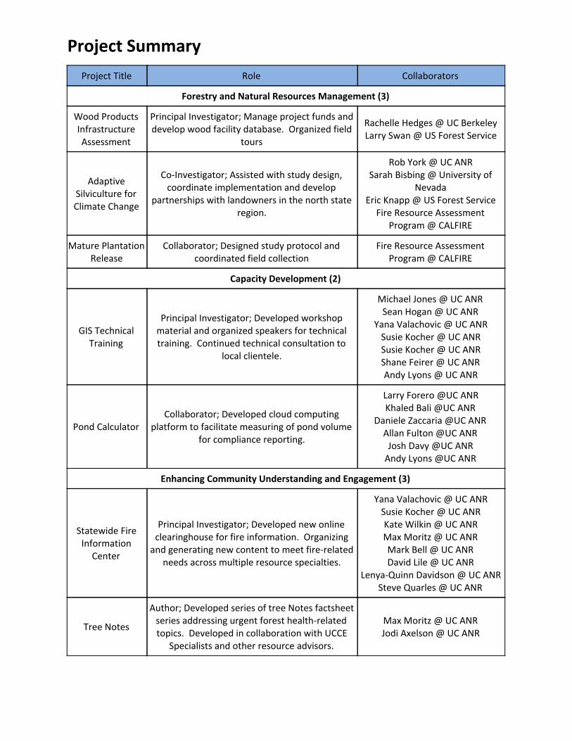
Project Summary
Project Title Role Collaborators
Forestry and Natural Resources Management (3)
Wood Products Infrastructure Assessment
Principal Investigator; Manage project funds and develop wood facility database. Organized field
tours
Rachelle Hedges @ UC Berkeley Larry Swan @ US Forest Service
Adaptive Silviculture for Climate Change
Co-Investigator; Assisted with study design, coordinate implementation and develop
partnerships with landowners in the north state region.
Rob York @ UC ANR Sarah Bisbing @ University of
Nevada Eric Knapp @ US Forest Service
Fire Resource Assessment Program @ CALFIRE
Mature Plantation Release
Collaborator; Designed study protocol and coordinated field collection
Fire Resource Assessment Program @ CALFIRE
Capacity Development (2)
GIS Technical Training
Principal Investigator; Developed workshop material and organized speakers for technical training. Continued technical consultation to
local clientele.
Michael Jones @ UC ANR Sean Hogan @ UC ANR
Yana Valachovic @ UC ANR Susie Kocher @ UC ANR Susie Kocher @ UC ANR Shane Feirer @ UC ANR Andy Lyons @ UC ANR
Pond Calculator Collaborator; Developed cloud computing
platform to facilitate measuring of pond volume for compliance reporting.
Larry Forero @UC ANR Khaled Bali @UC ANR
Daniele Zaccaria @UC ANR Allan Fulton @UC ANR
Josh Davy @UC ANR Andy Lyons @UC ANR
Enhancing Community Understanding and Engagement (3)
Statewide Fire Information
Center
Principal Investigator; Developed new online clearinghouse for fire information. Organizing
and generating new content to meet fire-related needs across multiple resource specialties.
Yana Valachovic @ UC ANR Susie Kocher @ UC ANR Kate Wilkin @ UC ANR Max Moritz @ UC ANR Mark Bell @ UC ANR David Lile @ UC ANR
Lenya-Quinn Davidson @ UC ANR Steve Quarles @ UC ANR
Tree Notes
Author; Developed series of tree Notes factsheet series addressing urgent forest health-related topics. Developed in collaboration with UCCE
Specialists and other resource advisors.
Max Moritz @ UC ANR Jodi Axelson @ UC ANR

Forestry Institute for Teachers
Natural Resources Director (Shasta); Organized natural resource curriculum and presenters for
local Shasta FIT session.
Yana Valachovic @ UC ANR John Helms @ Society of American
Foresters Ryan Tompkins @ UC ANR
Fire Preparedness Trainings
Principal; Delivered home and vegetation hardening training to communities in Shasta,
Trinity and Siskiyou Counties
Trinity County Resource Conservation District
Juniper Flat Fire Safe Council Siskiyou County Fire Safe Council
Shasta County
Professional Competence
A. Professional Development and Training
Begin Date - End Date
Location Name, Description and Occurrence of Activity
May 24, 2017 Webinar CalTrees Training - Pilot rollout of new online Timber Harvest Plan
submission system for private forest management in California.
Jun 7, 2017 Burney, CA SCIFMRC Meeting - Field tour with Sierra Cascade Intensive Forest
Management Research Cooperative to review ongoing and completed field trials of new herbicide compounds
Jun 27, 2017 Redding, CA Defensive Driving Training - Shasta County defensive driving class
Jun 28, 2017 Red Bluff, CA Contracts and Grants Training - Meeting with UCANR contracts and
grants team to review proper procedures when working with contracts and grants
Jul 25, 2017 - Jul 27, 2017
Davis, CA Drone Camp - IGIS training on research applications and processing
techniques for using remotely collected data
Aug 24, 2017 Redding Society of American Foresters Annual Meeting - Annual meeting of national professional forestry association for California membership
Sep 8, 2017 Chico, CA CLFA Annual Meeting - Annual meeting of licensed professional
forester association in California to discuss drought issue and new water policies
Oct 17, 2017 - Oct 19, 2017
Davis Programmatic Orientation - UCANR orientation for new academics to
meet colleagues and leadership
Oct 30, 2017 - Oct 31, 2017
Blodgett Forest Research Station
RX Burn Training - Participation with Blodgett Forest Research Station hosted burn crew training and prescribed fire
Nov 3, 2017 Williams, CA Forest Landowners of California Board Meeting - Annual meeting of
statewide forest landowner association discussing drought and wildfire concerns of members
Nov 3, 2017 Winters Forest Landowners of California Meeting - Annual meeting of forest
landowner association

Nov 7, 2017 Yreka, CA Siskiyou RX Fire Meeting - Inter-department meeting with groups in Siskiyou County involved with or interested in applying prescribed
fire on forestlands
Nov 30, 2017 Yreka, CA Siskiyou Tree Mortality Task Force - Annual meeting with Siskiyou
County task force to assess potential drought mortality concerns and solutions
Dec 8, 2017 Chester, CA DREGS - Annual meeting of Disturbance Regime Guided Silviculture professional forestry association and field tour of novel silviculture
strategies.
Jan 16, 2018 Redding, CA FVMC Conference - Annual Forest Vegetation Management
Conference to discuss new vegetation management techniques and compounds
Feb 11, 2018 Online Responsible Conduct of Research for Administrators - Online PI
training for ethics and project management
Feb 14, 2018 Online COI Training - Conflict of Interest training for National Science
Foundation and University of California compliance
Feb 25, 2018 Online UC Cyber Security Training - Annual cyber security training for UCANR
Mar 5, 2018 - Mar 7, 2018
Vancouver, BC ForestTechX Conference - Annual Forest Technology meeting on
LiDAR and remote technologies for use in forest operations
Apr 9, 2018 - Apr 12, 2018
Ontario, CA Statewide Conference - UCCE statewide meeting with program teams
and workgroups
Jul 17, 2018 Chester, CA Insect and Disease Training - Field training with California Forest Pest
Council on identification of common sierra species
Jul 18, 2018 Chester, CA Forest Vegetation Management Tour - Annual meeting with various
forest landowners to demonstrate new vegetation management strategies
Aug 16, 2018 Murphys, CA California SAF Annual Meeting - Annual meeting with California chapter of Society of American Foresters to discuss education
program and beetle kill issues
Jan 15, 2019 - Jan 17, 2019
Redding, CA FVMC Conference - Annual Forest Vegetation Management
Conference to discuss new vegetation management techniques and compounds
B. Disciplinary Society or Professional Association
Disciplinary Society/Prof. Assoc Name Membership/Meetings Attended/Activities
Pacific Forest Trust (Klamath-Cascade Advisory Group) Advisory Council Member
Disturbance Regime Guided Silviculture Group Member
Society of American Foresters (National) Member

Sierra-Cascade Intensive Forest Management Research Cooperative Affiliate
California Licensed Forester Association Affiliate Member
C. Evidence of Professional Competency
Begin Date - End Date
Location Name, Description and Occurrence of Award, Recognition, Professional
Presentation, Office or Activity
Aug 9, 2017 Junction City Trinity County Long Term Fire Planning Meeting - Post-fire recovery meeting for Junction City residents after Orleans Fire.
Nov 20, 2017 (Ongoing)
Online Forest Steward Newsletter Review Committee - Reviewer on quarterly newsletter on current forestry issues for California Landowners. Distribution reaches over 3500 landowners
Jan 18, 2018 Online Book Chapter Review - Reviewer on reforestation chapter of the California Forest Regeneration Manual
Jan 21, 2018 Online Article Review - Reviewer on forest fuel management article in the Journal of Rangeland Management
Feb 27, 2018 Burney Burney Basin FSC - Reviewer on Burney Basin Fire Safe Council meeting to approve updated to Burney Community Wildfire Protection Plan
Apr 19, 2018 Mt. Shasta, CA
KARE Annual Meeting - Keynote speaker at Klamath Alliance for Resources and Environment meeting on fire probability of federal and state responsibility areas
May 2, 2018 Redding, CA Stewardship Council Meeting - Represented UC in negotiations for fee title to Pacific Gas and Electric settlement lands in Shasta County
May 4, 2018 Redding, CA Western Shasta RCD - Field meeting to advise Western Shasta RCD on critical projects and direction for the upcoming year
Jun 7, 2018 (Ongoing)
Various Forest Mensuration Training - Ongoing field crew training of emergent foresters and undergraduate students on forest research measurement techniques
Jul 22, 2018 Meadow Valley, CA
UC Forestry Field Camp - Invited speaker on wood products and biomass opportunities in California
Aug 24, 2018 Lake Tahoe, CA
HWP Calculator Review - Reviewer of CalFire's Harvested Wood Product online calculator for agency and landowners to model timber management outputs
Sep 6, 2018 Arcata, CA Oak Restoration Workshop - Meeting to review findings of oak restoration effectiveness monitoring research and discuss new oak restoration exemptions with CalFire and NRCS
Dec 8, 2018 Redding, CA Post Fire Recovery Workshop - Presentation on hazard tree identification at Carr Fire recovery workshop

Dec 8, 2018 Tuolumne, CA VR Analysis - Cross training with USFS and Penn State researchers on utilizing virtual reality systems to improve forest outreach information
Dec 18, 2018 Weaverville, CA
Trinity Fire Hardening Workshop - Hosted workshop and organized speakers for defensible space recommendations.
Dec 19, 2018 Yreka, CA Siskiyou Fire Hardening Workshop - Hosted workshop and organized speakers for defensible space recommendations.
Jan 8, 2019 Sacramento, CA
Technical Advisory Committee - UC Davis Biomass Transportation Interconnection Tool
Jan 8, 2019 McClellan, CA Adaptive Silviculture for Climate Change - Planning meeting for 2019 year
Feb 22, 2019 - Feb 23, 2019
Folsom, CA Society of American Foresters Annual Winter Meeting
Feb 26, 2019 Redding, CA Klamath Cascade Advisory Council – PFT
Mar 1, 2019 Redding, CA Forest Vegetation Management Conference Planning Committee
Mar 1, 2019 - Mar 31, 2019
Online CCI Forest Health Research Grant Review Committee
Mar 8, 2019 - Mar 9, 2019
Anderson, CA California Licensed Foresters Association CLFA Annual Meeting
Mar 26, 2019 Redding, CA Technical Advisory Committee - Burney BioMAT Project
Sep 16, 2019 Online Forest Stewardship Education Initiative Steering Committee
University and Public Service
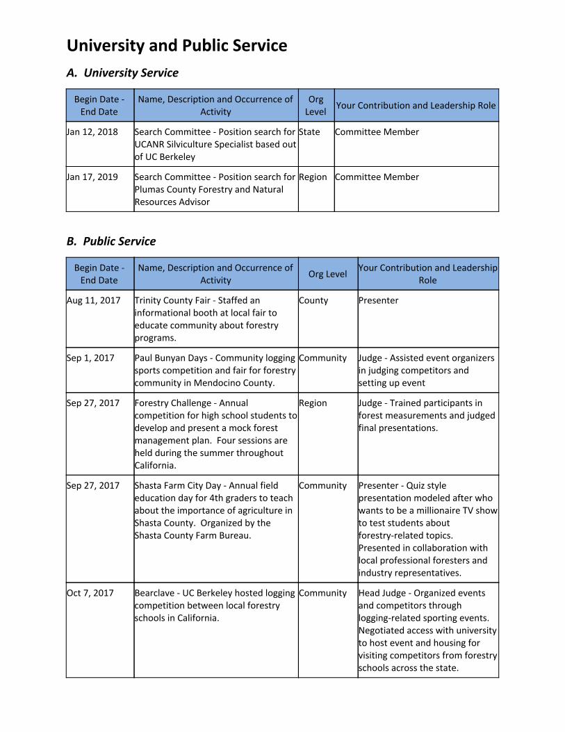
A. University Service
Begin Date - End Date
Name, Description and Occurrence of Activity
Org Level
Your Contribution and Leadership Role
Jan 12, 2018 Search Committee - Position search for UCANR Silviculture Specialist based out of UC Berkeley
State Committee Member
Jan 17, 2019 Search Committee - Position search for Plumas County Forestry and Natural Resources Advisor
Region Committee Member
B. Public Service
Begin Date - End Date
Name, Description and Occurrence of Activity
Org Level Your Contribution and Leadership
Role
Aug 11, 2017 Trinity County Fair - Staffed an informational booth at local fair to educate community about forestry programs.
County Presenter
Sep 1, 2017 Paul Bunyan Days - Community logging sports competition and fair for forestry community in Mendocino County.
Community Judge - Assisted event organizers in judging competitors and setting up event
Sep 27, 2017 Forestry Challenge - Annual competition for high school students to develop and present a mock forest management plan. Four sessions are held during the summer throughout California.
Region Judge - Trained participants in forest measurements and judged final presentations.
Sep 27, 2017 Shasta Farm City Day - Annual field education day for 4th graders to teach about the importance of agriculture in Shasta County. Organized by the Shasta County Farm Bureau.
Community Presenter - Quiz style presentation modeled after who wants to be a millionaire TV show to test students about forestry-related topics. Presented in collaboration with local professional foresters and industry representatives.
Oct 7, 2017 Bearclave - UC Berkeley hosted logging competition between local forestry schools in California.
Community Head Judge - Organized events and competitors through logging-related sporting events. Negotiated access with university to host event and housing for visiting competitors from forestry schools across the state.

Oct 12, 2017 FFA Field Day - Future Farmers of America field day competition hosted by Shasta College
Community Organizer - Supported tree identification and forestry challenge with equipment repair and grading of quiz exams
Jan 27, 2018 Bay Area SAF Field Day - Organized public event to educate and introduce local urban populations to forestry and forest management. Organized by the Bay Area chapter of the Society of American Foresters
Community Organizer - Assisted with setting up trails and educational booths throughout Russel Field Research Station in advance of public tours.
Feb 8, 2018 Sierra Cascade Logging Conference - Annual logging conference for logging equipment vendors to demonstrate new equipment. Also includes education component to promote the art, practice and standards of good logging and good forestry.
Community Coach - Supported logging sport demonstration event with set-up and maintaining safety of all competitors. Provided specific guidance on events to competitors from UC Berkeley and other forestry universities.
Feb 10, 2018 SCLC Education Day - Education Day at Sierra Cascade Logging Conference for elementary school students to learn about forest operations and management
Community Guide - Led two classes of 4th graders to various stops and taught about a variety of forestry subject ranging from wildlife to soil hydrophobicity
Apr 21, 2018 Whole Earth Watershed Festival - Local community-wide celebration of Earth Day to promote healthy living; to build healthy communities; and to restore a healthy planet. Attended to educate public about forestry, 4-H and Calfresh programs offered by UC Cooperative Extension
Community Presenter
Aug 10, 2018 Trinity County Fair - Staffed an informational booth at local fair to educate community about forestry program.
County Participant
Aug 14, 2018 - Aug 18, 2018
Disaster Assistance Center - Fire recovery center established by Office of Emergency Services to assist residents with recovery from the Carr Fire.
County Presenter - Assisted with hazard tree identification and locating appropriate resources for removal or restoration.
Feb 7, 2019 SCLC Education Day - Education Day at Sierra Cascade Logging Conference for elementary school students to learn about forest operations and management
Community Guide - Led two classes of 4th graders to various stops and taught about a variety of forestry subject ranging from wildlife to soil hydrophobicity
Feb 8, 2019 Sierra Cascade Logging Conference - Annual logging conference for logging
Community Coach - Supported logging sport demonstration event with set-up

equipment vendors to demonstrate new equipment. Also includes education component to promote the art, practice and standards of good logging and good forestry.
and maintaining safety of all competitors. Provided specific guidance on event to competitors from UC Berkeley and other forestry universities.
Apr 20, 2019 Watershed Festival Educational Presentation
Community Educator
Sep 25, 2019 Shasta Farm City Day - Annual field education day for 4th graders to teach about the importance of agriculture in Shasta County. Organized by the Shasta County Farm Bureau.
Community Presenter - Quiz style presentation modeled after who wants to be a millionaire TV show to test students about forestry-related topics. Presented in collaboration with local professional foresters and industry representatives.

Extension Activities
A. Meetings Organized
Begin Date - End Date
Meeting Name and Type Topic/no. of repetitions
Role Location(s) Attendees
Forestry and Natural Resources Management (5)
Nov 14, 2017
Western Statewide Wood Energy Team
Western State's Wood Energy Team annual meeting / 1
Organizer Fresno 52
Nov 16, 2017
Biomass Facility Field Tour
Biomass Plant Field Tour / 1
Collaborator Fresno 16
Dec 7, 2017 Wood Innovations Grant Webinar
Grant Review Workshop / 1
Organizer Online 52
Jun 9, 2018 Steep Slope Demonstration
Field Demonstration / 1
Organizer Ice House Resort, Pollock Pines, CA
186
Nov 26, 2018
Wood Innovations Grant Webinar
Grant Review Workshop / 1
Organizer Online 32
Capacity Development (5)
Oct 12, 2017
Shasta College Field Training
Forest Mensuration Training / 1
Organizer Latour State Demonstration Forest
20
Mar 25, 2018 - Mar 26, 2018
GIS Workshop Forest GIS Training for Professionals / 1
Organizer Shasta College
11
Apr 30, 2018
Forest GIS Retreat Forest inventory GIS database upgrade / 1
Organizer/Facilitator
Hopland 3
Mar 18, 2019 - Mar 19, 2019
GIS Workshop Forest GIS Training for Professionals / 1
Organizer Santa Rosa Junior College
33
Mar 22, 2019 - Mar 23, 2019
GIS Workshop Forest GIS Training for Professionals / 1
Organizer Humboldt State University
26
April 25, 2019 - April 26, 2019
GIS Workshop Forest GIS Training for Professionals / 1
Organizer Lake Tahoe Community College
28
May 10, 2019 - May 11, 2019
GIS Workshop Forest GIS Training for Professionals / 1
Organizer Shasta College
19

Sept 30, 2019
GIS Workshop Forest GIS Training for Students / 1
Organizer UC Berkeley 23
Enhancing Community Understanding and Engagement (3)
Jul 2, 2017 - Jul 8, 2017
Forestry Institute for Teachers
Forest Education and Training or K-12 Educators / 1
Program Co-Director
Shingletown, CA
36
Oct 29, 2017
Trinity County Post Fire Workshop
Post-Fire Recovery / 1
Speaker Weaverville, CA
32
Dec 8, 2017 Oak Recovery Planning Meeting - Post Carr Fire recovery planning for Shasta County
Oak Recovery / 1 Organizer Redding, CA 8
Jun 30, 2018 - Jul 8, 2018
Forestry Institute for Teachers
Forest Education and Training or K-12 Educators / 1
Organizer, Presentor, PI
Shingletown, CA
28
Sep 25, 2018
Post Fire Vegetation/Erosion Workshop
Post Fire Vegetation/Erosion Workshop / 1
Invited Speaker Redding, CA 300
Jan 5, 2019 Master Gardener Fire Training
Fire Hardening Workshop / 1
Invited Speaker Redding, CA 18
May 13, 2019
Fire Hardening Workshop
Fire Hardening Workshop
Invited Speaker Burney, CA 26
Jun 30, 2019 - Jul 8, 2019
Forestry Institute for Teachers
Forest Education and Training or K-12 Educators / 1
Organizer, Presentor, PI
Shingletown, CA
37
B. Other (including websites, social media, blogs, collaborations with other agencies, organizations, policy engagement)
Begin Date - End Date Description No. of Instances
Forestry and Natural Resources Management (6)
May 15, 2017 (Ongoing) CE Shasta Forestry (ceshasta.ucanr.edu) 1
May 15, 2017 (Ongoing) CE Trinity Forestry (cetrinity.ucanr.edu/forestry) 1
Aug 15, 2017 (Ongoing) UCCE Forest Outreach (ucanr.edu/forestry) 1
Oct 31, 2017 (Ongoing) Berkeley Forests (forests.berkeley.edu) 1
May 15, 2012 (Ongoing) Woody Biomass Utilization Group (ucanr.edu/Woodybiomass)
1
May 15, 2012 (Ongoing) California Statewide Wood Energy Team (ucanr.edu/sites/SWET)
1

Capacity Development (2)
May 15, 2017 (Ongoing) Sierra Cascade Intensive Forest Management Research Cooperative (ucanr.edu/sites/scifmrc)
1
Oct 31, 2018 (Ongoing) California Alumni Foresters (caf.berkeley.edu) 1
Enhancing Community Understanding and Engagement (2)
Dec 10, 2018 (Ongoing) UCCE Fire Outreach (ucanr.edu/fire) 1
Dec 10, 2018 (Ongoing) Forestry Institute for Teachers (Forestryinstitute.org)
1
C. Other (including TV and/or radio interviews/programs, newspaper/trade magazine interviews)
Begin Date - End Date Topic Name of Media or Publication
Capacity Development (1)
Aug 22, 2017 Women in Logging Sports Interview
MisAdventures Women's Outdoor Magazine
May 15, 2019 Forest Carbon Calculator Interview
Grist News Outlet

Ricky Satomi - Program Review Dossier 23
Bibliography
Peer Reviewed
Non-Peer Reviewed
A - Popular press articles 17
D- Technical Reports and other Non-Reviewed Articles 1
TOTAL 18
A - Popular press articles
● Satomi, Ricky (2017). Bark Beetles...Is my Forest at Risk? Tips and Topics 4-H Newsletter.
18:2. September.
● Satomi, Ricky (2017). Natural Resources Corner. Tips and Topics 4-H Newsletter. 17:10. June.
● Satomi, Ricky (2017). Wildfire Recovery: Now What? Tips and Topics 4-H Newsletter. 18:3.
October.
● Satomi, Ricky (2017). Wildfire Recovery: Preparing for the Winter. Tips and Topics 4-H
Newsletter. 18:5. December.
● Satomi, Ricky (2018). Assessing Tree Damage. UCANR Tree Notes. 1. September.
● Satomi, Ricky (2018). Christmas Tree Guide. Tips and Topics 4-H Newsletter. 19:4.
November.
● Satomi, Ricky; Wilkin, Kate; Mortiz, Max (2018). Evacuation Checklist.
● Satomi, Ricky (2018). New Efforts in Protecting Communities from Wildfire. Tips and Topics
4-H Newsletter. 18:10. June.
● Satomi, Ricky (2018). Weed not Seed. UCANR Tree Notes. 2. October.
● Satomi, Ricky (2018). What is a Fire Safe Home? Tips and Topics 4-H Newsletter. 18:7.
March.
● Satomi, Ricky (2018). Whispering Woods: Dendrochronology 101. Tips and Topics 4-H
Newsletter. 18:9. May.
● Satomi, Ricky (2018). Wildfire Recovery: Next Steps. Tips and Topics 4-H Newsletter. 19:2.
September.
● Forero, Larry; Satomi, Ricky; Bali, Khaled; Zaccaria, Daniele; Fulton, Allan; Davy, Josh (2019).
Determining Volume in a Small Pond with a Staff Gauge. Northern California Ranch Update.
7:1. August.

Ricky Satomi - Program Review Dossier 24
● Satomi, Ricky (2019). Road Engineering. Tips and Topics 4-H Newsletter. 19:8. April.
● Satomi, Ricky (2019). Tracking Fire. Tips and Topics 4-H Newsletter. 19:12. November.
● Satomi, Ricky (2019). Understanding Wildfire Threat to Homes. Tips and Topics 4-H
Newsletter. 19:6. February.
● Satomi, Ricky (2019). What is a Tree Worth. Tips and Topics 4-H Newsletter. 19:10.
September.
D - Technical reports and other non-reviewed articles
● Satomi, Ricky; Lyons, Andy; Johnson, Robert; Feirer, Shane; Hogan, Sean (2019). Forest GIS
Basics. 01, 30.

It is the policy of the University of California (UC) and the UC Division of Agriculture & Natural Resources not to engage in discrimination against or harassment of any person in any of its programs or activities (Complete
nondiscrimination policy statement can be found athttp://ucanr.edu/sites/anrstaff/files/215244.pdf) Inquiries regarding ANR’s nondiscrimination policies may be directed Affirmative Action Compliance and Title IX Officer,
University of California, Agriculture and Natural Resources, 2801 Second Street, Davis, CA 95618, (530) 750-1397.
Tree Notes
Before clearing your landscape of fire-damaged trees, check to see if they will recover. Native California trees have
several adaptations that helps them survive, or recover quickly from fire damage. If a tree does not pose an
immediate hazard to health or property, provide it with an opportunity to recover.
Cut Hardwoods when…
1. The cambium is completely dead around the base
of the tree. To check, cut small openings in the bark
to expose the cambium layer underneath.
2. Unlike conifers, Oaks can survive even when all the
foliage has burned off. The tree may even produce
new foliage this year.
3. If the trunk has been killed, many oaks will resprout
from the roots in the spring. Root sprouts grow
much faster than new shoots from acorn plantings.
Cut Conifers when….
1. The tree is small (< 6 inches in diameter) and the
bark is charred or exposed continuously around the
base.
2. Less than 25% of the crown remains green on the
tree. Conifers only produce one set of foliage each
year whereas oaks can potentially re-leaf after a
fire.
3. If uncertain, check if the cambium is moist. A slow
burning fire may leave the foliage green, but kill the
live cambium tissue of the tree.
For more information about tree damage and recovery, contact your Shasta County CE Forest Advisor (530.224.4900) or Master Gardeners (530.242.2219)
Live Branches
Burned Branches
Surviving trees
have Pink,
Moist, and light
colored wood
under the bark
Dead trees will
have Brown,
Dry, dark
colored wood
under the bark

What is a Tree Worth?
How many goats can you buy with a tree? (answer: Depends on the tree)
Foresters determine a value of a tree based on a variety of factors. The Size of the tree, the Quality of the wood, and
even the Type of tree determines how it is valued.
To measure a tree, we need to first think about how it is used. At your local hardware store, one may notice that most
wood is sold as boards, not cylinders. This is because building a house or deck is more difficult when using material with
rounded edges. A other feature ou’ll oti e are that lumber is rarely sold in lengths greater than 32 feet. This is
because a standard log is cut to 32 feet before transport to a sawmill. These standards help us with consistency in the
harvesting and manufacturing of our wood products.
When estimating the revenue from a timber harvest, we must estimate the number of
Board-Feet i a tree. Board-feet is a forester’s unit of measurement to represent
how many boards can be cut from a log. A single board-foot is equal in volume to a
oard, but that does ot ea that oards a o l e ade out of trees. Instead, each log is assessed by a sawyer to produce the greatest number of
usable boards.
Several Log Rules exist to help us estimate the number of boards that can be
manufactured from a single log. In California, the Scribner Decimal C Scale is most
commonly used. These rules consider log taper, length of tree, straightness of tree,
and even decay pockets when calculating how many usable boards can be produced.
The standardization of log lengths also mean that the tops of a tree often do not have
arket alue. For e a ple, o a 75’ tree, ou ould o l e a le to produ e t o ’ logs. The last ’ o the top of the tree ould ot o l e too short to tra sport, ut also tapered so severely that no usable lumber could be produced.
Like ice cream flavors, not all species of trees are valued the same. Some are better suited for building homes while
others are better for making the fencing and decking surrounding our homes. In addition, market demand for particular
products (i.e. structural beams for manufacturing homes) and local environmental factors (i.e. surplus wood from wildfire
salvage) can significantly affect the value of each species. The California Department of Tax and Fee Administration
(https://www.cdtfa.ca.gov/taxes-and-fees/timber-tax.htm) provides timber values every year to help determine how
much a tree is worth when you file taxes.
These are just a few of the factors that impact how much value can be produced from a tree. There are numerous
considerations that a professional forester takes into account when helping you plan and implement a timber harvest.
• Harvesting wood in a forest requires several fixed costs including road construction, environmental review and
plan documentation. The impact of these costs therefore reduced when larger areas or more trees are harvested
at the same time.
• International markets can also have a significant impact. Changes to trade agreements can impact the demand
for material (i.e. pencil wood sold to China, lumber purchased from Canada) as well as how much purchasers are
willing to pay for that material.
• Naturally occurring bark beetles and fungal discoloration of wood can also lower the aesthetic value and sale
price of the finished lumber.
For additional information, check in with your local UCCE Forestry Advisor (1-530-224-4900), California Forest Stewardship Helpline
(1-800-738-8733), or Resource Conservation District office or find more information at:
ceshasta.ucanr.edu/Forestry

Determining Volume in a Small Pond with a Staff Gauge and Depth Capacity CurveLarry Forero, Ricky Satomi, Allan Fulton, Khaled Bali, Daniele Zaccaria and Josh Davy
INTRODUCTION and BACKGROUND
Determining stored water volume in ponds and reservoirs is required for many landowners throughout California. Pursuant to SB88, the California State Water Resources Control Board (SWRCB) now requires monitoring of surface water being diverted and put to beneficial use. Stock water ponds are also included in this regulation.
Exceptions to these reporting requirements include individuals who receive all of their water through a municipal water system, public water agency or private water agency. In these cases, the city, agency, or entity that delivers water is responsible for SWRCB reporting. Any questions related to specific water measurement requirements can be submitted to:
Division of Water Rights:
Phone: (916) 341-5300
Reporting: [email protected]
Measurement: [email protected]
Depending on the size of your pond, the frequency of reporting pond volume will vary. As of 2019, the reporting requirements listed by the water board are:
https://www.waterboards.ca.gov/waterrights/water_issues/programs/diversion_use/water_use.html
A depth-capacity curve (sometimes called a pond curve) demonstrates the relationship between pond depth (as read on a staff gauge) and water volume at that depth. This article provides a method to develop a depth-capacity curve for individual ponds. Ponds with a capacity of ten acre-feet or less typically fall into a “stock pond” category under which owners are allowed to estimate the monthly change in storage volume (typically increases during the rainy season and decreases during dry season). Under SB88, smaller ponds under 100-acre feet will require an individual with experience in measurement and monitoring to design and install measurement equipment. For ponds over 100-acre feet, land managers have the option to complete the UC water measurement course so they can select and install their own measurement devices (pond owners with under 100 acre feet of storage may also want to take this course to become more familiar with water measurement terms and techniques). If this option is chosen, the land manager can only design and install measurement devices on their own land. For land managers who are not inclined to “do it yourself” they have the option to hire a professional contractor or engineer to do to do this for them.
Pond Size (Acre feet) Required Monitoring Frequency
<10 Monthly- (Estimation is allowed)10-49 Monthly
50-199 Weekly200-999 Daily>1,000 Hourly

1. Stock Ponds (<10 acre feet): While depth-capacity curves are less essential for < 10 acre feet ponds, the calculator is still useful in determining and documenting the overall capacity of the ponds, but is optional and not required by the state.
2. Ponds (between 10 and 49 acre-feet): A depth-capacity curve is a practical method for determining pond volume. Monitoring and recording monthly changes in volume can likely be done visually.
3. Ponds (with a volume greater than 50 acre-feet): For larger ponds, the development of a depth capacity curve using this method is still valid, however the reporting requirement (weekly, daily or hourly) will likely require the use of an automated device(i.e., pressure transducer) to collect depth data practically.
Since stock ponds aren’t flat bottomed, the simplest way to monitor water volume is with a depth capacity curve showing the total volume stored at various water levels throughout the season. While depth capacity curves are available for some ponds in CA, it is not uncommon for ponds constructed decades ago to have never had a staff gauge installed or a depth capacity curve developed. If your pond is registered with the Bureau of Dam Safety, was designed by the USDA Natural Resource Conservation Service (NRCS) or local Resource Conservation District (RCD), or was surveyed during an inspection by the SWRCB, a depth capacity curve may be available. Check with those agencies first.
Licensees of ponds (Water Right IDs begin with ‘A’) can send an email request to the SWRCB at [email protected] with the Water Right IDs of interest, to see if the Division has an existing depth capacity curve or survey information that the diverter can use to construct their own curve. The SWRCB does not maintain survey information for Domestic, Permits, Irrigation, or Livestock Registrations (Water Right IDs beginning with ‘D,’ ‘H,’ or ‘L,’ respectively); Stockpond Certificates (Water Right IDs beginning with ‘C’); or Riparian and Pre-1914 claims of right (Water Right IDs beginning with ‘S’).
DEVELOPING A POND CURVE
If a depth capacity curve can’t be found, one will need to be developed. This can be accomplished by measuring the water depth and corresponding surface area of the pond for at least three different levels between full and empty. An installed staff gauge (Fig. 1) is crucial to monitoring the fill level of the pond. Because of the irregularity of many reservoir bottoms, the staff gauge needs to be installed in a location that represents the average ground level of the bottom of the pond. A handheld GPS unit (or smart phone with GPS capability) can then be used to determine surface area (Fig. 2). Using these tools and the online calculator, you can develop your own depth capacity curve.
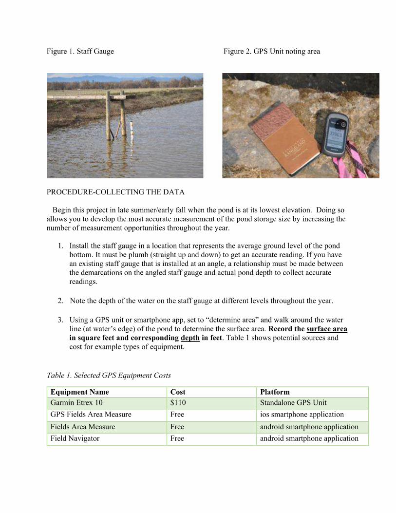
Figure 1. Staff Gauge Figure 2. GPS Unit noting area
PROCEDURE-COLLECTING THE DATA
Begin this project in late summer/early fall when the pond is at its lowest elevation. Doing so allows you to develop the most accurate measurement of the pond storage size by increasing the number of measurement opportunities throughout the year.
1. Install the staff gauge in a location that represents the average ground level of the pondbottom. It must be plumb (straight up and down) to get an accurate reading. If you havean existing staff gauge that is installed at an angle, a relationship must be made betweenthe demarcations on the angled staff gauge and actual pond depth to collect accuratereadings.
2. Note the depth of the water on the staff gauge at different levels throughout the year.
3. Using a GPS unit or smartphone app, set to “determine area” and walk around the waterline (at water’s edge) of the pond to determine the surface area. Record the surface areain square feet and corresponding depth in feet. Table 1 shows potential sources andcost for example types of equipment.
Table 1. Selected GPS Equipment Costs
Equipment Name Cost PlatformGarmin Etrex 10 $110 Standalone GPS UnitGPS Fields Area Measure Free ios smartphone applicationFields Area Measure Free android smartphone applicationField Navigator Free android smartphone application
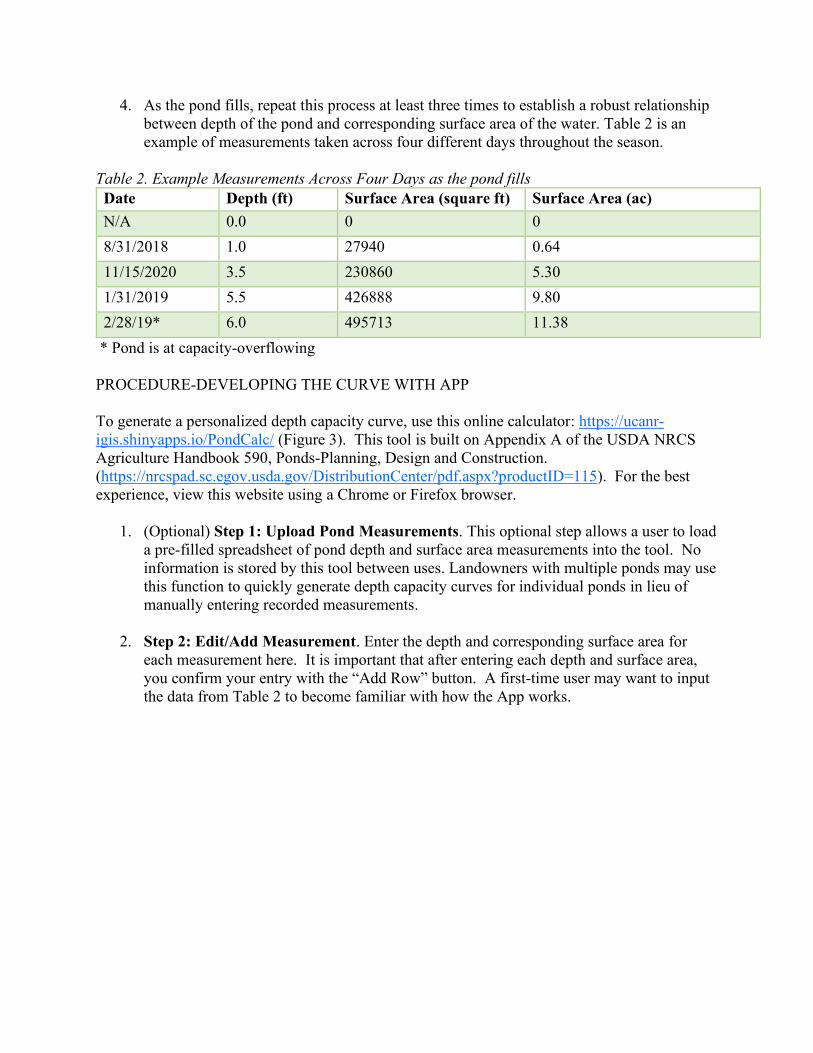
4. As the pond fills, repeat this process at least three times to establish a robust relationshipbetween depth of the pond and corresponding surface area of the water. Table 2 is anexample of measurements taken across four different days throughout the season.
Table 2. Example Measurements Across Four Days as the pond fills Date Depth (ft) Surface Area (square ft) Surface Area (ac)N/A 0.0 0 08/31/2018 1.0 27940 0.6411/15/2020 3.5 230860 5.301/31/2019 5.5 426888 9.802/28/19* 6.0 495713 11.38* Pond is at capacity-overflowing
PROCEDURE-DEVELOPING THE CURVE WITH APP
To generate a personalized depth capacity curve, use this online calculator: https://ucanr-igis.shinyapps.io/PondCalc/ (Figure 3). This tool is built on Appendix A of the USDA NRCS Agriculture Handbook 590, Ponds-Planning, Design and Construction. (https://nrcspad.sc.egov.usda.gov/DistributionCenter/pdf.aspx?productID=115). For the best experience, view this website using a Chrome or Firefox browser.
1. (Optional) Step 1: Upload Pond Measurements. This optional step allows a user to loada pre-filled spreadsheet of pond depth and surface area measurements into the tool. Noinformation is stored by this tool between uses. Landowners with multiple ponds may usethis function to quickly generate depth capacity curves for individual ponds in lieu ofmanually entering recorded measurements.
2. Step 2: Edit/Add Measurement. Enter the depth and corresponding surface area foreach measurement here. It is important that after entering each depth and surface area,you confirm your entry with the “Add Row” button. A first-time user may want to inputthe data from Table 2 to become familiar with how the App works.

Figure 3. Screenshot of the Pond Volume Calculator
3. As you enter collected data (depth and corresponding surface area), a pond measurementtable (Figure 4, left) and pond curve (Figure 4, Right) will be automatically generated.
a. Please Note: The depth capacity curve will only populate once sufficientmeasurements have been submitted to produce a curve with relative confidence.
b. Use the table to review the data modeling your curve. If an incorrect measurementis present, click on the incorrect row to select the value, and click “Removeselected rows”. The depth capacity curve should adjust automatically.
Figure 4. (Left) Pond Measurement table showing submitted depth and surface area. (Right) Calculated Depth Capacity Curve showing relationship between pond depth and water volume (acre-feet)

DETERMINING CHANGE IN POND VOLUME
A pond curve demonstrates the relationship between pond depth (as read on a staff gauge) and water volume at that depth. The online calculator derives the depth capacity curve with a three-factor polynomial equation that is suitable for most ponds. To improve the accuracy of the curve, increase the number of data points (pond depth and corresponding surface area). This app will not be accurate if islands or channels are cut into the pond.
Once a pond curve is developed (Figure 4 Right), it can be used to track changes in total volume using staff gauge readings.
1. If you want to know the change in volume during the month of November, you would note the staff gauge reading on November 1st and November 30th.
2. In this example, the staff gauge reads 3.0’ on November 1st and 4.0’ on November 30th. a. Reading the completed pond curve can identify the corresponding volume
estimate at these depths (Figure 5). b. By estimating the pond volumes at 5 acre feet and 10 acre feet during the two
periods, the increase in volume can be estimated to be 5 acre feet. (Table 3)
Table 3 Volume change data based on pond curve.
Date Staff Gauge Read
Staff Gauge Reading
Volume Estimate from Depth Capacity Curve
Calculated Volume from Online Calculator
November 1 3.0’ ~5 acre feet 5.37 acre feet November 30 4.0’ ~10 acre feet 10.66 acre feet
Change
5 acre feet 5.29 acre feet
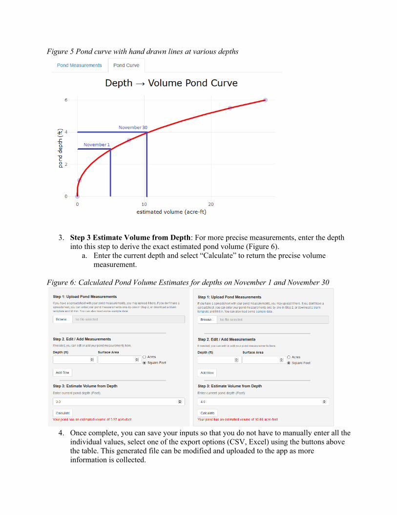
Figure 5 Pond curve with hand drawn lines at various depths
3. Step 3 Estimate Volume from Depth: For more precise measurements, enter the depthinto this step to derive the exact estimated pond volume (Figure 6).
a. Enter the current depth and select “Calculate” to return the precise volumemeasurement.
Figure 6: Calculated Pond Volume Estimates for depths on November 1 and November 30
4. Once complete, you can save your inputs so that you do not have to manually enter all theindividual values, select one of the export options (CSV, Excel) using the buttons abovethe table. This generated file can be modified and uploaded to the app as moreinformation is collected.

Figure 7
REPORTING DIVERSION VOLUME TO THE SWRCBThe need for data collection and development of a pond curve is to meet SWRCB reporting requirements for established stored water. Diversion volume must be reported on-line using the SWRCB online portal.
Access to the online reporting process portal is only available to landowners with recorded ponds. If no record exists for the pond the owner will need to file an Initial Statement of Diversion (https://www.waterboards.ca.gov/waterrights/water_issues/programs/diversion_use/docs/intl_stmnt_form.pdf) or register a stockpond (<10 acre feet storage). For more information go to the SWRCB website (https://www.waterboards.ca.gov/waterrights/water_issues/programs/registrations/#stockpond)
If the SWRCB has your water right on record (i.e., has issued a stockpond certificate or reservoir permit or license), the agency will acknowledge this by issuing the owner a username and password. Without a username and password, the online reporting process cannot be initiated.
1. The SWRCB on-line reporting system is called eWRIMS and can be accessed at:https://www.waterboards.ca.gov/waterrights/water_issues/programs/ewrims/. Thesoftware will ask for user for username and password information. Once thesecredentials are established, the user will be promoted through a series of questionsassociated with their diversion.
2. Eventually the user will reach a screen asking for diversion information by month.The volume of water reported here should be in acre feet regardless of the requiredmeasuring interval. For situations where the measuring requirement is more frequentthan monthly, the interval measurement data must be distilled to reflect the totalmonthly water diverted. The data used to calculate monthly volume diverted willneed to be uploaded to the eWRIMS system. Figure 7 is an example of the form

where volume of water diverted to storage by month is completed. Using the example from table 3, note that 5.29 acre feet was added to storage in the month of November. That number is entered on report form.
3. Note that no water was “beneficially used”. If water from this pond were used forirrigation or stock watering during the summer months, the amount of water put to abeneficial use would be recorded.
Figure 7. Example of SWRCB monthly reporting form

Glossary
Acre-Foot – A volume of water that can be most easily visualized as one acre in area
(approximately the size of a football field) that is one foot deep. However, the surface area and
depth dimensions may vary. An acre-foot of water equates to 43,560 cubic feet of water or
325,851 gallons.
Android smartphone application – cellular devices offered by Samsung and other competing
manufacturers.
Beneficially Used - California water law defines many beneficial uses including domestic,
agricultural, and environmental uses. For purposes of SB88 reporting, irrigation is a primary
beneficial use.
California State Water Resources Control Board (SWRCB – The State Water Resources
Control Board. The regulating agency in California responsible for enforcement of SB88 water
measurement and reporting California surface water diversions.
Depth-Capacity Curve (Pond Curve)- : A graphical representation of the volume of water in a
pond when filled or emptied to different levels. A pond curve is typically curve-a-linear and not
linear due to irregular pond depths and shapes.
Diversion Volume – The volume of water diverted between two measurement dates, possibly
monthly or weekly. This can be water that is either diverted into the pond or removed from
storage
Engineers scale: Measurement instrument with gradation in feet and tenth of feet (rather than
feet and inches).
GPS Unit – An electronic device capable of connecting to satellites and used to accurately track
one’s position on earth. Useful for measuring distances and land areas or changes in distances and land areas over time. Smartphones typically have GPS capabilities.
Groundwater: Water that is extracted from the ground. Typically, a well and pump
arrangement. Where wells are located near surface water sources and there is connectivity to the
surface water, the extraction through a well might be considered surface water.
IOS smartphone application – cellular devices offered by Apple, Inc.
Plumb: Exactly straight vertically
Pond Capacity: The stored volume of water just prior to reaching the spillway. This includes
the volume up to the top of the spillway, and volume retained by any freeboard above that.
Pond Volume – The amount of space occupied by water in a pond. A three-dimensional
measurement of length times width time depth. Usually expressed in cubic feet or acre-feet.
Pressure transducer: Electronic device that measures and records the elevation of water above
it at a programmed interval (i.e., hourly).

Staff Gauge – A stationary measurement rod or post properly located in the pond that is clearly
marked in feet and tenths of feet to conveniently measure change in water elevation of pond.
Surface Area – The uppermost or outer part of a layer. A two-dimensional expression of length
multiplied by width that is usually expressed as square feet or acres.
Surface water: Water that flows on top of the ground
United States Department of Agriculture Natural Resource Conservation Service (USDA-
NRCS) a federal agency under the Department of Interior responsible for oversight and
management of land resources in the United States. A USDA NRCS office is located in each
county of California.
Water right: Legal authority to divert and/or store water.
Summary of Publication Examples
Satomi, Ricky (2017). What is a Tree Worth? Tips and Topics 4-H Newsletter . 19:10. September. This article provides a simple guide to wood valuation in California. It introduces some of the key concepts that drive lumber valuation in California. I wrote the article to provide local 4-H families and communities with a primer on the quantitative and qualitative techniques used to calculate wood value.
Satomi, Ricky (2018). Assessing Tree Damage. UCANR Tree Notes. 1. September. This article provides detailed guidance on post-fire tree mortality identification. Developed in response to the Carr, Delta, and Hirz Fire in Shasta County, I wrote the article to complement existing literature from agency counterparts. This novel media format was developed to provide detailed UC information without overwhelming landowner capacity to digest information after disaster.
Forero, Larry; Satomi, Ricky; Bali, Khaled; Zaccaria, Daniele; Fulton, Allan; Davy, Josh (2019). Determining Volume in a Small Pond with a Staff Gauge. Northern California Ranch Update . 7:1. August.
This article was developed to help landowners meet new reporting requirements in California. I designed a web-based tool with support from IGIS to provide a low-cost pond volume calculator. By pairing common smartphones with a web-based model, readers are able to quickly measure and track changes in pond volume. I supported lead author Forero et al with developing model calculations and use guidance to optimize application of the tool.