Mediterranean megaturbidite triggered by the AD 365 Crete ...
12
Mediterranean megaturbidite triggered by the AD 365 Crete earthquake and tsunami Alina Polonia 1 , Enrico Bonatti 1,2 , Angelo Camerlenghi 3 , Renata Giulia Lucchi 3 , Giuliana Panieri 1 & Luca Gasperini 1 1 ISMAR-CNR (Istituto di Scienze Marine), Via Gobetti 101, 40129 Bologna, Italy, 2 Lamont-Doherty Earth Observatory, 61 Rte 9w, Palisades, NY 10964, United States, 3 OGS (Istituto Nazionale di Oceanografia e di Geofisica Sperimentale), Borgo Grotta Gigante 42/C, 34010, Sgonico (TS), Italy. Historian Ammianus Marcellinus documented the devastating effects of a tsunami hitting Alexandria, Egypt, on July 21, AD 365. "The solidity of the earth was made to shake … and the sea was driven away. The waters returning when least expected killed many thousands by drowning. Huge ships… perched on the roofs of houses… hurled miles from the shore….’’. Other settlements around the Mediterranean were hit at roughly the same time. This scenario is similar to that of the recent Sumatra and Tohoku tsunamis. Based on geophysical surveys and sediment cores from the Ionian Sea we show that the 20–25 m thick megaturbidite known in the literature as Homogenite/Augias was triggered not by the Santorini caldera collapse but by the 365 AD Cretan earthquake/tsunami. An older similar megaturbidite was deposited after 14.590 6 80 yr BP, implying a large recurrence time of such extreme sedimentary events in the Mediterranean Sea. E xtreme submarine geo-hazards, such as strong earthquakes, tsunamis, volcanic eruptions and submarine landslides have affected repeatedly the circum Mediterranean highly populated coastal regions. A record of these past events can be provided by large-volume turbidites or megaturbidites 1 , detected in the marine sedimentary record. Megaturbidites can be triggered by ground acceleration from seismic events 2 , impact on the seafloor of tsunami waves 3 , volcanic activity 4 , sea-level changes 5 , gas hydrate phase changes 6 or a combination of any of these processes. Megaturbidites have been identified in the Ionian basin, a deep and thickly sedimented relict of the Tethis Ocean 7 . It contains sedimentary sequences spanning from Jurassic to the present, that includes, in its upper part, about 2 km of Messinian (Late Miocene) evaporites overlain by Plio-Quaternary sediments 8 . The basin is located between the tectonically active Calabria and Hellenic subduction zones (to the North and to the East respectively), the Malta escarpment to the West and the African plate passive margin to the South (Fig. 1). Post evaporitic deposits consist of alternating pelagic sediments (including sapropels and tephras) and turbidites. Turbidites and megaturbidites are prevalent in the flat deep basin floor (Ionian and Sirte abyssal plains) and on the rims of the Calabrian and Mediterranean ridges, while hemipelagic sedimentation prevails on topographic highs 9 . The recentmost megaturbidite, described for the first time in 1975 10 was named either ‘‘Homogenite’’ 3 , or ‘‘Augias homogenite’’ 11 or ‘‘Augias turbidite’’ 12 . The term Homogenite was introduced to indicate the apparently homogeneous and structureless, very-fine grained sediments forming the uppermost part of the megabed. ‘‘Homogenite’’ is therefore a descriptive term initially used to indicate a deposit having sedimentary character- istics similar to the ‘‘unifites’’ 13 . The Homogenite has been detected from different tectonic and physiographic settings 14 . Type A Homogenite 15 refers to pelagic turbidites of local origin, up to seven metre-thick, deposited in small perched basins of the Calabrian and Western Mediterranean Ridges, deriving from sediment liquefaction and resuspension triggered by the repeated passage of a tsunami wave. Type B Homogenite refers to a terrigenous megaturbidite, in places up to 25 m thick 15,16 , recovered in the Sirte and central Ionian abyssal plains and in the Western Herodotus Trough. It was triggered by the tsunami wave hitting the Northern African shallow water shelf and coastline. The exceptional thickness of Type B Homogenite prevented recovery of its coarse-grained base in most cases. The Augias turbidite 12 refers to Type B Homogenite 15 as discussed in ref 17. In order to avoid misunderstanding, in this paper we refer to the Homogenite/Augias Turbidite as HAT. SUBJECT AREAS: GEOLOGY TECTONICS MINERALOGY SEISMOLOGY Received 24 October 2012 Accepted 28 January 2013 Published 15 February 2013 Correspondence and requests for materials should be addressed to A.P. (alina.polonia@ ismar.cnr.it) SCIENTIFIC REPORTS | 3 : 1285 | DOI: 10.1038/srep01285 1
Transcript of Mediterranean megaturbidite triggered by the AD 365 Crete ...
Mediterranean megaturbidite triggeredby the AD 365 Crete earthquake andtsunamiAlina Polonia1, Enrico Bonatti1,2, Angelo Camerlenghi3, Renata Giulia Lucchi3,Giuliana Panieri1 & Luca Gasperini1
1ISMAR-CNR (Istituto di Scienze Marine), Via Gobetti 101, 40129 Bologna, Italy, 2Lamont-Doherty Earth Observatory, 61 Rte 9w,Palisades, NY 10964, United States, 3OGS (Istituto Nazionale di Oceanografia e di Geofisica Sperimentale), Borgo GrottaGigante 42/C, 34010, Sgonico (TS), Italy.
Historian Ammianus Marcellinus documented the devastating effects of a tsunami hitting Alexandria,Egypt, on July 21, AD 365. "The solidity of the earth was made to shake … and the sea was driven away. Thewaters returning when least expected killed many thousands by drowning. Huge ships… perched on theroofs of houses… hurled miles from the shore….’’. Other settlements around the Mediterranean were hit atroughly the same time. This scenario is similar to that of the recent Sumatra and Tohoku tsunamis. Based ongeophysical surveys and sediment cores from the Ionian Sea we show that the 20–25 m thick megaturbiditeknown in the literature as Homogenite/Augias was triggered not by the Santorini caldera collapse but by the365 AD Cretan earthquake/tsunami. An older similar megaturbidite was deposited after 14.590 6 80 yr BP,implying a large recurrence time of such extreme sedimentary events in the Mediterranean Sea.
Extreme submarine geo-hazards, such as strong earthquakes, tsunamis, volcanic eruptions and submarinelandslides have affected repeatedly the circum Mediterranean highly populated coastal regions. A record ofthese past events can be provided by large-volume turbidites or megaturbidites1, detected in the marine
sedimentary record. Megaturbidites can be triggered by ground acceleration from seismic events2, impact on theseafloor of tsunami waves3, volcanic activity4, sea-level changes5, gas hydrate phase changes6 or a combination ofany of these processes.
Megaturbidites have been identified in the Ionian basin, a deep and thickly sedimented relict of the TethisOcean7. It contains sedimentary sequences spanning from Jurassic to the present, that includes, in its upper part,about 2 km of Messinian (Late Miocene) evaporites overlain by Plio-Quaternary sediments8. The basin is locatedbetween the tectonically active Calabria and Hellenic subduction zones (to the North and to the East respectively),the Malta escarpment to the West and the African plate passive margin to the South (Fig. 1).
Post evaporitic deposits consist of alternating pelagic sediments (including sapropels and tephras) and turbidites.Turbidites and megaturbidites are prevalent in the flat deep basin floor (Ionian and Sirte abyssal plains) and on therims of the Calabrian and Mediterranean ridges, while hemipelagic sedimentation prevails on topographic highs9.
The recentmost megaturbidite, described for the first time in 197510 was named either ‘‘Homogenite’’3, or‘‘Augias homogenite’’11 or ‘‘Augias turbidite’’12. The term Homogenite was introduced to indicate the apparentlyhomogeneous and structureless, very-fine grained sediments forming the uppermost part of the megabed.‘‘Homogenite’’ is therefore a descriptive term initially used to indicate a deposit having sedimentary character-istics similar to the ‘‘unifites’’13.
The Homogenite has been detected from different tectonic and physiographic settings14. Type A Homogenite15
refers to pelagic turbidites of local origin, up to seven metre-thick, deposited in small perched basins of theCalabrian and Western Mediterranean Ridges, deriving from sediment liquefaction and resuspension triggeredby the repeated passage of a tsunami wave. Type B Homogenite refers to a terrigenous megaturbidite, in places upto 25 m thick15,16, recovered in the Sirte and central Ionian abyssal plains and in the Western Herodotus Trough. Itwas triggered by the tsunami wave hitting the Northern African shallow water shelf and coastline. The exceptionalthickness of Type B Homogenite prevented recovery of its coarse-grained base in most cases. The Augiasturbidite12 refers to Type B Homogenite15 as discussed in ref 17. In order to avoid misunderstanding, in thispaper we refer to the Homogenite/Augias Turbidite as HAT.
SUBJECT AREAS:GEOLOGY
TECTONICS
MINERALOGY
SEISMOLOGY
Received24 October 2012
Accepted28 January 2013
Published15 February 2013
Correspondence andrequests for materials
should be addressed toA.P. (alina.polonia@
ismar.cnr.it)
SCIENTIFIC REPORTS | 3 : 1285 | DOI: 10.1038/srep01285 1
The stratigraphic position of the HAT, defined in tens of sedimentcores above the regional stratigraphic marker sapropel S1, has beeninterpreted as evidence for deposition in a single, basin-wide eventcapable to put into suspension simultaneously sediment at a basin-wide scale. To date, the HAT is a unique example of the multipleeffects that a tsunami wave can produce on deep sea sedimentation ina Mediterranean type basin such as the Ionian Sea. Absence of abso-lute dating of the HAT and of a detailed chronostratigraphy of thedeposits above and below the HAT, have allowed different correla-tions with known historic natural catastrophes in the EasternMediterranean region.
The original hypothesis, put forward by3,11,18 and elaborated inseveral other researche articles18–21 for nearly 30 years, attributedthe HAT to the 3500 yr BP Minoan eruption of Santorini and relatedtsunamis originated in the Aegean Sea. This chronology was based onthe linear extrapolation of sedimentation rate between the top of
sapropel S1 (8000 yr B.P.) and the seafloor assuming no erosionwas caused by deposition of Type A Homogenites.
The improvement of tsunami modeling led to question the effec-tiveness of the tsunami wave generated by the Santorini calderacollapse, especially outside the Aegean Sea, and to propose that thehomogenite was generated by a tsunami driven by the collapse of theeastern flank of the Etna Volcano22. This reconstruction was criti-cized23 based on the incongruent chronology between the Etna flankcollapse, the Santorini caldera collapse, and the age of the sapropelS1. This led to the suggestion that the Homogenite might be related toa 365 AD major earthquake in Crete23. No novel data nor detailedgeological or radiometric data analysis accompanied this hypothesis.
We present here the results of acoustic surveys of the HAT in theIonian Sea, as well as HAT’s mineralogy, micropaleontology, ele-mental and isotopic geochemistry and radiocarbon dating, basedon studies of sediment cores we collected from the Ionian seafloor.
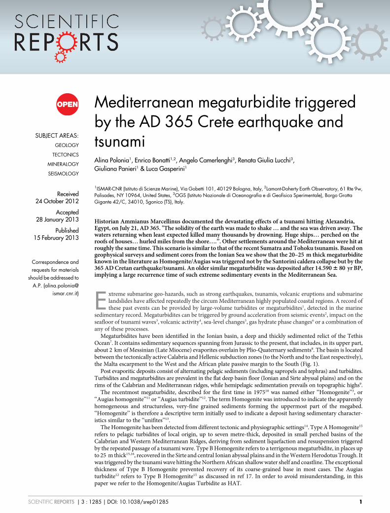
Figure 1 | Shaded relief map of topography/bathymetry of the central and eastern Mediterranean Sea. Shaded relief map of topography/bathymetryof the central and eastern Mediterranean Sea: Global Bathymetry and Elevation Data from SRTM30_PLUS (Becker et al., 2009). Yellow areas indicate
the extent of HAT deposits according to ref 12. Yellow dots represent homogenite bearing coring stations after ref 20. Green dots represent homogenite
bearing gravity cores after this study while red dots represent the two gravity cores described in this manuscript (cores CALA 04 and CALA 05).
Section A-A9 is a bathymetric profile from the AD 365 epicentre to the Malta escarpment, crossing coring stations CALA 04 and 205. Bottom:
bathymetric profile A-A9 that shows the very steep topographic gradient (up to 30u) of the Malta Escarpement with a large vertical displacement of the
seafloor (.2000 m) relative to the basin floor. The top of the escarpment represents the edge of a wide continental shelf in the Sicily Channel. Dotted
yellow line represents tsunami waves after 709 after the earthquake34.
www.nature.com/scientificreports
SCIENTIFIC REPORTS | 3 : 1285 | DOI: 10.1038/srep01285 2
Guided by online sub-bottom CHIRP seismic data, we were able, infact, to sample the top and base of the megaturbidite in differentsedimentary basins of the Ionian Sea by carefully selecting sites whereit has its minimum thickness.
The objective is to identify the event or events that triggered thedeposition of the HAT, and to assess the recurrence time of suchmajor catastrophic events in the Mediterranean.
ResultsSub-bottom acoustic profiles of the HAT. High resolution sub-bottom CHIRP seismic profiles identified the HAT in the Ionianabyssal plain as a laterally continuous, acoustically transparentnear surface layer (Fig. 2 and Supplementary S1). It has a uniformthickness of about 15 m in the deep basin while it pinches out to a fewmeters towards the basin’s margins. The HAT correlates on sub-bottom profiles, with the Augias turbidite described in previousworks24,25 (see Supplementary S1).
The HAT is not limited to the abyssal plain (Type B Homogenite15
and Augias turbidite12); we can acoustically document the HAT alsoin confined perched basins on the continental slope both of the outerCalabrian Arc accretionary wedge (Type A Homogenite15) and, forthe first time, in the inner portions of the subduction complex, about100 km from the Calabrian coastline (Fig. 1), where its thicknessranges from 1 to 3 m. Other thick acoustically transparent layers havebeen detected beneath the HAT (Fig. 2b and Supplementary S1) thatmay be correlated to the DTL (Deep Transparent Layer) and TTL(Thick Transparent Layer) of ref 25.
Composition of the HAT. We detected the HAT in 12 of the 19 coresretrieved from the abyssal plain and slope basins (Fig. 1). We selectedcore CALA 05 for a high resolution multidisciplinary study whileradiometric dating has been performed both on CALA 05 and CALA04 (see section on methods).
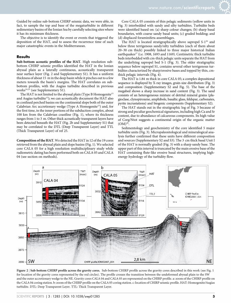
Core CALA 05 consists of thin pelagic sediments (yellow units inFig. 3) interbedded with sandy and silty turbidites. Turbidite bedswere identified based on: (a) sharp colour changes; (b) sharp basalboundaries, with coarse sandy basal units; (c) graded bedding; and(d) displaced foraminifera assemblages.
The HAT is located stratigraphically above sapropel S-126 andbelow three terrigenous sandy/silty turbidites (each of them about20–30 cm thick) possibly linked to three major historical Italianearthquakes27 (i.e. 1908, 1693 and 1169). Centimetric thick turbiditebeds interbedded with cm-thick pelagic units separate the HAT fromthe underlying sapropel bed S-1 (Fig. 3). The older stratigraphicsequence below sapropel S1, contains several other terrigenous tur-bidites characterized by sharp/erosive bases and topped by thin, cm-thick pelagic intervals (Fig. 4).
The HAT is 1.84 m thick in core CALA 05; a complex depositionalsequence is displayed by X-ray images, grain-size distribution (Fig. 3)and composition (Supplementary S2 and Fig. 5). The base of themegabed shows a sharp increase in sand content (Fig. 3). The sandconsists of an heterogeneous mixture of detrital mineral grains (pla-gioclase, clynopiroxene, amphibole, basaltic glass, feldspar, carbonates,pyrite incrustations) and biogenic components (Supplementary S2).
The HAT stands out in the stratigraphic log of Fig. 3 because ofstrong and peculiar geochemical signatures, including high Ca and Srcontent, due to abundance of calcareous components. Its high valueof Corg/Ntot suggests a continental origin of the organic matter(OM)28.
Sedimentology and geochemistry of the core identified 5 majorturbidite units (Fig. 3). Micropaleontological and mineralogical ana-lysis further confirmed that these units have different compositionand sources (Supplementary S2 and S3). The 3 cm thick basal Unit Iof the HAT is normally graded (Fig. 3) with a sharp sandy base. Theupper part of this interval is truncated by the main erosive base of theHAT containing flute-like erosive basal structures, implying high-energy hydrology of the turbidity flow.
Figure 2 | Sub-bottom CHIRP profile across the gravity cores. Sub-bottom CHIRP profile across the gravity cores described in this work (see Fig. 1
for location of the gravity cores represented by the red circles). The profile crosses the transition between the undeformed abyssal plain to the SW
and the outer accretionary wedge to the NE. Gravity cores CALA 04 and CALA 05 are represented on the CHIRP profile. a: zoom of the CHIRP profile on
the CALA 04 coring station. b: zoom of the CHIRP profile on the CALA 05 coring station. c: location of CHIRP seismic profile. HAT: Homogenite/Augias
turbidite. DTL: Deep Transparent Layer. TTL: Thick Transparent Layer.
www.nature.com/scientificreports
SCIENTIFIC REPORTS | 3 : 1285 | DOI: 10.1038/srep01285 3
The 15 cm thick dark brown sandy Unit II is characterized by2–3 cm inversely graded basal sand with alternating mm-thicklight and dark levels containing abundant biogenic components(Supplementary 2). Above this interval the sequence is normally
graded, although we distinguished 5 peaks of increased sandconcentration, each marked by an increase of Zr and Fe content.X-ray analyses of Unit II reveals a complex pattern of alternatingplanar and cross-laminations separated by sharp surfaces marked by
Figure 3 | Photograph, X-ray image, sedimentary facies, grain size and geochemical data of core CALA 05. From left to right: Photograph with
overprinted the magnetic susceptibility profile, X-ray image, sedimentary facies, grain-size, major XRF geochemical elements, lightness profiles and OM
content. Recognized turbidites (T1-T7), pelagic units (P0-P5), sapropel S1 are indicated. Numbered (from 1 to 19) red dotted lines represent sand peaks
in the different HAT units. Analysed samples and 14C dated samples are indicated by green and red rectangles respectively. MS: Magnetic Susceptibility.
www.nature.com/scientificreports
SCIENTIFIC REPORTS | 3 : 1285 | DOI: 10.1038/srep01285 4
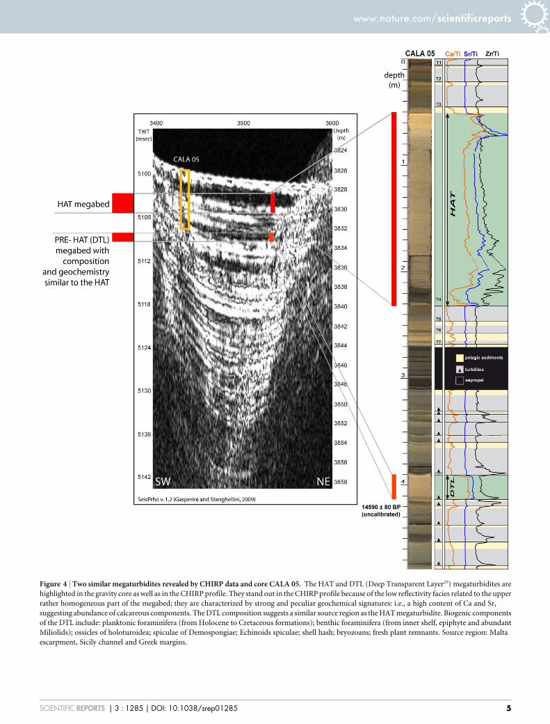
Figure 4 | Two similar megaturbidites revealed by CHIRP data and core CALA 05. The HAT and DTL (Deep Transparent Layer25) megaturbidites are
highlighted in the gravity core as well as in the CHIRP profile. They stand out in the CHIRP profile because of the low reflectivity facies related to the upper
rather homogeneous part of the megabed; they are characterized by strong and peculiar geochemical signatures: i.e., a high content of Ca and Sr,
suggesting abundance of calcareous components. The DTL composition suggests a similar source region as the HAT megaturbidite. Biogenic components
of the DTL include: planktonic foraminifera (from Holocene to Cretaceous formations); benthic foraminifera (from inner shelf, epiphyte and abundant
Miliolids); ossicles of holoturoidea; spiculae of Demospongiae; Echinoids spiculae; shell hash; bryozoans; fresh plant remnants. Source region: Malta
escarpment, Sicily channel and Greek margins.
www.nature.com/scientificreports
SCIENTIFIC REPORTS | 3 : 1285 | DOI: 10.1038/srep01285 5
increasing grain size (Fig. 3). In some cases, amalgamated intervals ofcross-laminated sediments show opposite dipping trends, suggestingreversal of flow direction.
The sharp and irregular base of Unit III is marked by acolour change and a decrease in sand content. Planar andcross-laminations are present, as well as grain size fluctuationswith at least 6 sandy peaks. This unit shows a relative enrich-ment in OM.
Unit IV is limited at the base by a sharp contact separating thesand-silt parallel and cross laminations of unit III from a depositionalsequence that includes the following sub-units: a) a basal debrite(mud chips visible on the Xray images in a homogenous mudmatrix); b) alternation of cross, planar and convoluted/cross lami-nated layers; c) texturally uniform sediments with faint, sand free,laminations.
Unit V consists of structureless, very-fine grained sediments withan upward decrease of OM content. At the base, unit Va shows asharp basal boundary visible on X-ray images with low magneticsusceptibility and geochemical anomalies; unit Vb shows an abruptincrease in clay content and is marked by colour variation; the upper-most unit Vc corresponds to geochemical anomalies and evidencesof bacteria activity. A millimetric black and reddish horizon is pre-sent at the top of the HAT (Figs. 3 and 5a), enriched in Fe and Mn andwith abundant Fe/Mn micro-nodules. This horizon could represent adiagenetic red-ox front marking the top of the turbidite29, caused bymobilization of Fe and Mn within the turbidite following thedevelopment of reducing condition induced by the rapid sedimentaccumulation. The fine-grained upper part of the HAT has anincreased concentration of organic carbon whose bacterial oxidation(Fig. 3) may lead to reduction of Fe and Mn oxides and sulphates.
The HAT differs from the non-sapropelic pelagic intervals for itshigher Corg/Ntot ratio (Fig. 3), suggesting a prevailing terrestrial ori-gin of the organic matter. Highest Corg/Ntot ratios are found in thelowermost coarsest part (Units I, II, and III), which includes abund-ant land-derived plant debris. Conversely, the enrichment of clayparticles in the fine-grained fraction favours the absorption ofammonia, thus decreasing the Corg/Ntot ratio.
Only another decimetric thick carbonatic-sandy turbidite wasrecovered at the base of the core (Fig. 4). Correlation with CHIRPdata (Figs. 2, 4 and Supplementary S1) suggests it may be the DTLlayer25 (Fig. 4 and Supplementary S1). The HAT and DTL stand outin the CHIRP profiles (Fig. 4 and Supplementary S1) because of thelow reflectivity facies at the upper rather homogeneous part of themegabeds. Both these turbidites are characterized by strong andpeculiar geochemical signatures, including a high content of Caand Sr, suggesting abundance of calcareous components. The DTLcomposition suggests a similar source region as the HAT megatur-bidite (Fig. 4).
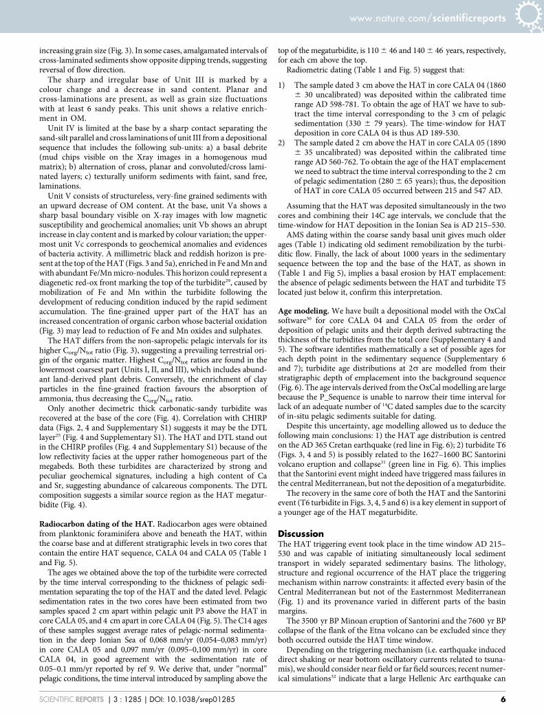
Radiocarbon dating of the HAT. Radiocarbon ages were obtainedfrom planktonic foraminifera above and beneath the HAT, withinthe coarse base and at different stratigraphic levels in two cores thatcontain the entire HAT sequence, CALA 04 and CALA 05 (Table 1and Fig. 5).
The ages we obtained above the top of the turbidite were correctedby the time interval corresponding to the thickness of pelagic sedi-mentation separating the top of the HAT and the dated level. Pelagicsedimentation rates in the two cores have been estimated from twosamples spaced 2 cm apart within pelagic unit P3 above the HAT incore CALA 05, and 4 cm apart in core CALA 04 (Fig. 5). The C14 agesof these samples suggest average rates of pelagic-normal sedimenta-tion in the deep Ionian Sea of 0,068 mm/yr (0,054–0,083 mm/yr)in core CALA 05 and 0,097 mm/yr (0.095–0,100 mm/yr) in coreCALA 04, in good agreement with the sedimentation rate of0.05–0.1 mm/yr reported by ref 9. We derive that, under ‘‘normal’’pelagic conditions, the time interval introduced by sampling above the
top of the megaturbidite, is 110 6 46 and 140 6 46 years, respectively,for each cm above the top.
Radiometric dating (Table 1 and Fig. 5) suggest that:
1) The sample dated 3 cm above the HAT in core CALA 04 (18606 30 uncalibrated) was deposited within the calibrated timerange AD 598-781. To obtain the age of HAT we have to sub-tract the time interval corresponding to the 3 cm of pelagicsedimentation (330 6 79 years). The time-window for HATdeposition in core CALA 04 is thus AD 189-530.
2) The sample dated 2 cm above the HAT in core CALA 05 (18906 35 uncalibrated) was deposited within the calibrated timerange AD 560-762. To obtain the age of the HAT emplacementwe need to subtract the time interval corresponding to the 2 cmof pelagic sedimentation (280 6 65 years); thus, the depositionof HAT in core CALA 05 occurred between 215 and 547 AD.
Assuming that the HAT was deposited simultaneously in the twocores and combining their 14C age intervals, we conclude that thetime-window for HAT deposition in the Ionian Sea is AD 215–530.
AMS dating within the coarse sandy basal unit gives much olderages (Table 1) indicating old sediment remobilization by the turbi-ditic flow. Finally, the lack of about 1000 years in the sedimentarysequence between the top and the base of the HAT, as shown in(Table 1 and Fig 5), implies a basal erosion by HAT emplacement:the absence of pelagic sediments between the HAT and turbidite T5located just below it, confirm this interpretation.
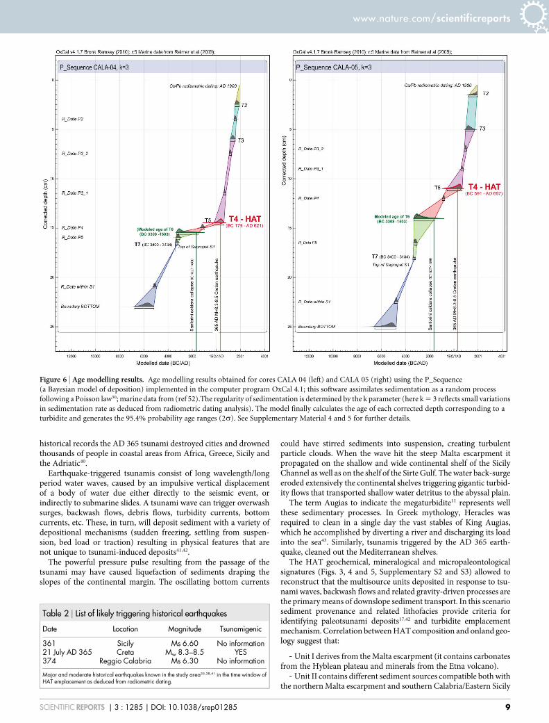
Age modeling. We have built a depositional model with the OxCalsoftware30 for core CALA 04 and CALA 05 from the order ofdeposition of pelagic units and their depth derived subtracting thethickness of the turbidites from the total core (Supplementary 4 and5). The software identifies mathematically a set of possible ages foreach depth point in the sedimentary sequence (Supplementary 6and 7); turbidite age distributions at 2s are modelled from theirstratigraphic depth of emplacement into the background sequence(Fig. 6). The age intervals derived from the OxCal modelling are largebecause the P_Sequence is unable to narrow their time interval forlack of an adequate number of 14C dated samples due to the scarcityof in-situ pelagic sediments suitable for dating.
Despite this uncertainty, age modelling allowed us to deduce thefollowing main conclusions: 1) the HAT age distribution is centredon the AD 365 Cretan earthquake (red line in Fig. 6); 2) turbidite T6(Figs. 3, 4 and 5) is possibly related to the 1627–1600 BC Santorinivolcano eruption and collapse31 (green line in Fig. 6). This impliesthat the Santorini event might indeed have triggered mass failures inthe central Mediterranean, but not the deposition of a megaturbidite.
The recovery in the same core of both the HAT and the Santorinievent (T6 turbidite in Figs. 3, 4, 5 and 6) is a key element in support ofa younger age of the HAT megaturbidite.
DiscussionThe HAT triggering event took place in the time window AD 215–530 and was capable of initiating simultaneously local sedimenttransport in widely separated sedimentary basins. The lithology,structure and regional occurrence of the HAT place the triggeringmechanism within narrow constraints: it affected every basin of theCentral Mediterranean but not of the Easternmost Mediterranean(Fig. 1) and its provenance varied in different parts of the basinmargins.
The 3500 yr BP Minoan eruption of Santorini and the 7600 yr BPcollapse of the flank of the Etna volcano can be excluded since theyboth occurred outside the HAT time window.
Depending on the triggering mechanism (i.e. earthquake induceddirect shaking or near bottom oscillatory currents related to tsuna-mis), we should consider near field or far field sources; recent numer-ical simulations32 indicate that a large Hellenic Arc earthquake can
www.nature.com/scientificreports
SCIENTIFIC REPORTS | 3 : 1285 | DOI: 10.1038/srep01285 6
produce a much higher tsunami wave in our working area thantsunami waves originating in closer regions. This implies that pos-sible triggering events (Table 2) include major earthquakes from theregions facing the Ionian Sea, such as the Calabrian Arc subduction
system8,33, the Hellenic Arc34 or to the Easternmost Mediterraneanand northern Africa thrust belts35,36.
Sicily and Calabria in southern Italy have been struck re-peatedly by strong and destructive earthquakes37 often with
Figure 5 | Radiocarbon ages derived from dating the pelagic intervals. Uncalibrated radiocarbon ages derived from dating the pelagic intervals above
and below the megabed in cores CALA 04 and 05. The overlying pelagic samples from the two cores yield a cluster of ages between 215–530 (calibrated).
There is a greater scatter in the underlying samples. The best estimate for the emplacement time of the megabed is thus given by the dates of the upper
pelagic units. The age of the Santorini caldera collapse and the top of the sapropels S1 are also indicated. a: zoom of the top of the HAT represented by the
mm-thick reddish and black level enriched in Fe and Mn and with abundant Fe/Mn micronodules; 1: coloured microphotograph of the sediment fraction
of the pelagic unit P3 above the HAT. 2: coloured microphotograph of the sediment fraction within the HAT basal unit III. 3: coloured microphotograph
of the sediment fraction within the HAT basal unit II. 4: coloured microphotograph of the sediment fraction within the HAT basal unit I. See
Supplementary Material 2 and 3 for details on the composition.
www.nature.com/scientificreports
SCIENTIFIC REPORTS | 3 : 1285 | DOI: 10.1038/srep01285 7
tsunamis38. However, events such as the Ms 6.60, AD 361 Sicilianand Ms 6.30, AD 374 Reggio Calabria (Table 2) had too low amagnitude to account for the remobilisation of such a largevolume of sediments in so wide an area as in the HAT event.These medium magnitude earthquakes can not account forground peak accelerations required to perturb stability condi-tions of slope sediments39 especially 600–700 km away fromthe epicentre.
The only historical earthquake potentially capable of generatingdevastating effects in the Ionian Sea, the Sirte abyssal plain and the
Herodotus Trough during the given time interval, is the exception-ally strong Cretan 365 AD earthquake34.
The AD 365 Cretan earthquake occurred on a major reverse fault,dipping beneath Crete and cropping out near the Hellenic Trench.The best fitting model of fault slip (length 100 km, dip 30u, slip 20 mto a depth of about 45 km) calls for an earthquake of magnitude8.3–8.534. Calculations of tsunamis triggered by this event show anopen ocean amplitude of the tsunami wave compatible with thatobserved and modelled in the 2004 Sumatra tsunami, with presum-ably similar devastating effects on the coastal regions. According to
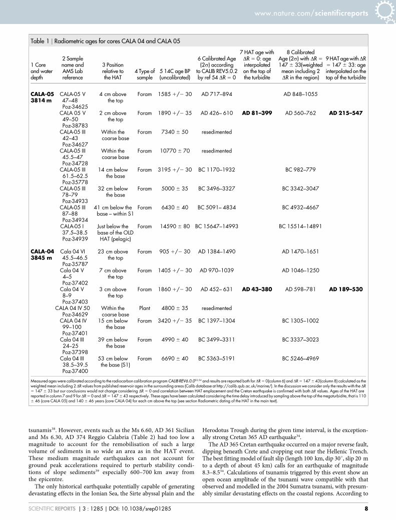
Table 1 | Radiometric ages for cores CALA 04 and CALA 05
1 Coreand waterdepth
2 Samplename andAMS Labreference
3 Positionrelative tothe HAT
4 Type ofsample
5 14C age BP(uncalibrated)
6 Calibrated Age(2s) according
to CALIB REV5.0.2by ref 54 DR 5 0
7 HAT age withDR 5 0: ageinterpolatedon the top ofthe turbidite
8 CalibratedAge (2s) with DR 5
147 6 33(weightedmean including 2DR in the region)
9 HAT age withDR5 147 6 33: ageinterpolated on thetop of the turbidite
CALA-053814 m
CALA-05 V47–48Poz-34625
4 cm abovethe top
Foram 1585 1/2 30 AD 717–894 AD 848–1055
CALA 05 V49–50Poz-38783
2 cm abovethe top
Foram 1890 1/2 35 AD 426– 610 AD 81–399 AD 560–762 AD 215–547
CALA-05 III42–43Poz-34627
Within thecoarse base
Foram 7340 6 50 resedimented
CALA-05 III45.5–47Poz-34728
Within thecoarse base
Foram 10770 6 70 resedimented
CALA-05 III61.5–62.5Poz-35778
14 cm belowthe base
Foram 3195 1/2 30 BC 1170–1932 BC 982–779
CALA-05 III78–79Poz-34933
32 cm belowthe base
Foram 5000 6 35 BC 3496–3327 BC 3342–3047
CALA-05 III87–88Poz-34934
41 cm below thebase – within S1
Foram 6430 6 40 BC 5091– 4834 BC 4932–4667
CALA-05 I37.5–38.5Poz-34939
Just below thebase of the OLDHAT (pelagic)
Foram 14590 6 80 BC 15647–14993 BC 15514–14891
CALA-043845 m
Cala 04 VI45.5–46.5Poz-35787
23 cm abovethe top
Foram 905 1/2 30 AD 1384–1490 AD 1470–1651
Cala 04 V4–5Poz-37402
7 cm abovethe top
Foram 1405 1/2 30 AD 970–1039 AD 1046–1250
Cala 04 V8–9Poz-37403
3 cm abovethe top
Foram 1860 1/2 30 AD 452– 631 AD 43–380 AD 598–781 AD 189–530
CALA 04 IV 50Poz-34629
Within thecoarse base
Plant 4800 6 35 resedimented
CALA 04 IV99–100Poz-37401
15 cm belowthe base
Foram 3420 1/2 35 BC 1397–1304 BC 1305–1002
Cala 04 III24–25Poz-37398
39 cm belowthe base
Foram 4990 6 40 BC 3499–3311 BC 3337–3023
Cala 04 III38.5–39.5Poz-37400
53 cm belowthe base (S1)
Foram 6690 6 40 BC 5363–5191 BC 5246–4969
Measured ages were calibrated according to the radiocarbon calibration program CALIB REV6.0.053,54 and results are reported both forDR 5 0(column 6) andDR 5 147 6 43(column 8) calculated as theweighted mean including 2DR values from published reservoir ages in the surrounding areas (Calib database at http://calib.qub.ac.uk/marine/). In the discussion we consider only the results with the DR5 147 6 33 but our conclusions would not change considering DR 5 0 and correlation between HAT emplacement and the Cretan earthquake is confirmed with both DR values. Ages of the HAT arereported in column 7 and 9 forDR 5 0 andDR 5 147 6 43 respectively. These ages have been calculated considering the time delay introduced by sampling above the top of the megaturbidite, that is 1106 46 (core CALA 05) and 140 6 46 years (core CALA 04) for each cm above the top (see section Radiometric dating of the HAT in the main text).
www.nature.com/scientificreports
SCIENTIFIC REPORTS | 3 : 1285 | DOI: 10.1038/srep01285 8
historical records the AD 365 tsunami destroyed cities and drownedthousands of people in coastal areas from Africa, Greece, Sicily andthe Adriatic40.
Earthquake-triggered tsunamis consist of long wavelength/longperiod water waves, caused by an impulsive vertical displacementof a body of water due either directly to the seismic event, orindirectly to submarine slides. A tsunami wave can trigger overwashsurges, backwash flows, debris flows, turbidity currents, bottomcurrents, etc. These, in turn, will deposit sediment with a variety ofdepositional mechanisms (sudden freezing, settling from suspen-sion, bed load or traction) resulting in physical features that arenot unique to tsunami-induced deposits41,42.
The powerful pressure pulse resulting from the passage of thetsunami may have caused liquefaction of sediments draping theslopes of the continental margin. The oscillating bottom currents
could have stirred sediments into suspension, creating turbulentparticle clouds. When the wave hit the steep Malta escarpment itpropagated on the shallow and wide continental shelf of the SicilyChannel as well as on the shelf of the Sirte Gulf. The water back-surgeeroded extensively the continental shelves triggering gigantic turbid-ity flows that transported shallow water detritus to the abyssal plain.
The term Augias to indicate the megaturbidite11 represents wellthese sedimentary processes. In Greek mythology, Heracles wasrequired to clean in a single day the vast stables of King Augias,which he accomplished by diverting a river and discharging its loadinto the sea43. Similarly, tsunamis triggered by the AD 365 earth-quake, cleaned out the Mediterranean shelves.
The HAT geochemical, mineralogical and micropaleontologicalsignatures (Figs. 3, 4 and 5, Supplementary S2 and S3) allowed toreconstruct that the multisource units deposited in response to tsu-nami waves, backwash flows and related gravity-driven processes arethe primary means of downslope sediment transport. In this scenariosediment provenance and related lithofacies provide criteria foridentifying paleotsunami deposits17,42 and turbidite emplacementmechanism. Correlation between HAT composition and onland geo-logy suggest that:
- Unit I derives from the Malta escarpment (it contains carbonatesfrom the Hyblean plateau and minerals from the Etna volcano).
- Unit II contains different sediment sources compatible both withthe northern Malta escarpment and southern Calabria/Eastern Sicily
Figure 6 | Age modelling results. Age modelling results obtained for cores CALA 04 (left) and CALA 05 (right) using the P_Sequence
(a Bayesian model of deposition) implemented in the computer program OxCal 4.1; this software assimilates sedimentation as a random process
following a Poisson law30; marine data from (ref 52).The regularity of sedimentation is determined by the k parameter (here k 5 3 reflects small variations
in sedimentation rate as deduced from radiometric dating analysis). The model finally calculates the age of each corrected depth corresponding to a
turbidite and generates the 95.4% probability age ranges (2s). See Supplementary Material 4 and 5 for further details.
Table 2 | List of likely triggering historical earthquakes
Date Location Magnitude Tsunamigenic
361 Sicily Ms 6.60 No information21 July AD 365 Creta Mw 8.3–8.5 YES374 Reggio Calabria Ms 6.30 No information
Major and moderate historical earthquakes known in the study area35,38,41 in the time window ofHAT emplacement as deduced from radiometric dating.
www.nature.com/scientificreports
SCIENTIFIC REPORTS | 3 : 1285 | DOI: 10.1038/srep01285 9
(minerals compatible with the metamorphic basement of southernCalabria and from the Etna volcano).
- Unit III contains material derived from the Sicily Channelas shown by the abundance in foraminiferal assemblages ofepiphytic species mainly belonging to Spirillina vivipara (seeSupplementary S3); by the isotopic composition of organic matter(Supplementary S8) suggesting relict organic matter of continentalorigin; and by the presence of cold water species. The back washsurge caused by the tsunami therefore must have eroded sedimentdeposited during the last sealevel lowstand (LGM) when the SicilyChannel was mostly exposed subaereally44.
- Units IV and V, composed of fine clay-rich sediments, could berelated to the final stage of turbidite emplacement, when the finesuspended load or ‘‘foam’’, settled down from the water column.
Seismic shaking from a single, although large, event, is probablynot capable of triggering giant turbidity currents 600–800 km fromthe epicentre. The analysis of shake maps of an earthquake of similarmagnitude (the M 5 8.2 April 11 2012 earthquake off the west coastof northern Sumatra45) produced peak ground acceleration (PGA) inthe order of 0.003–0.028 g about 500 km far from the epicenter.Results from slope stability back-calculations imply PGS’s largerthan 0.14 g to trigger turbidity currents for sediment strength inthe order of 5–6 kPa39. Seismic shaking from the Cretan earthquake,although exceptional, was probably unable to trigger mass move-ments 600–800 km from the epicenter in a flat and stable area ofthe Sicily channel.
Some of the HAT components are compatible with a source in theinner part of the Sicily Channel, and they suggest that tsunami waves,rather than seismic shaking, mobilized sediments from this region,although far from the epicentre, and carried them into the deepabyssal plain. Tsunami modelling in the Ionian Sea22 shows thatthe areas more prone to slope instability are those of the MaltaEscarpment, Eastern Sicily and Southern Calabria, that are, in fact,source areas of the HAT, as deduced by our study.
According to simulation models34, the tsunami wave generated bythe 365 AD Cretan earthquake hit orthogonally the edge of the Maltaescarpment 70 minutes after the event (Fig. 1); the Malta escarpmentis very steep (up to 30u) with a large vertical displacement of theseafloor(.2000 m) relative to the basin floor. The top of the escarp-ment represents the edge of a wide continental shelf in the SicilyChannel. Therefore, the Malta escarpment must have produced adramatic impact with the tsunami wave that hit it nearly orthogon-ally, with amplitude increase and wavelength shortening, reflected inincreased shear stress at the seafloor. This scenario could explain whythe HAT is recovered mostly in the Ionian and Sirte abyssal plainsand the Herodotus trough (Fig. 1), with a maximum thickness ofabout 25 m16, while it is absent elsewhere in the EasternmostMediterranean46, where the tsunami wave hit the continental marginobliquely, with no vertical relief allowing the wave to cause shearstresses at the seafloor. Nevertheless, according to tsunami modelresults34 the city of Alexandria located on the western side of the Niledelta, was devastated by the tsunami wave due to a peculiar coastaltopography which favoured the inundation from a wave propagatingfrom the SW parallel to the coastline. The inundation of Alexandriain AD 365 has remained in the historical record as the main disasterfollowing the Cretan earthquake because it was the most populatedand flourishing city in the region. Indeed there is historical record ofdisasters by the tsunami also in other Ionian coastline settlements40.
Paleo-shoreline observations in Crete suggests that the 365 ADearthquake was the only large seismic event in that region in the past1650 yrs34, in agreement with the observation that no other turbiditessimilar to the HAT are present in the uppermost sedimentarysequence of our cores. Based on GPS deformation rates and estimatesof co-seismic slip affecting marine terraces a ,4,500 years recur-rence time for AD 365 type earthquakes has been suggested34.
Only another turbidite bed has been observed in our cores withsedimentological and geochemical characters similar to the HAT.The only other carbonate turbidite observed in our cores lies beneathsapropel S1. This older turbidite is visible in our high-resolutionchirp sonar images and shows high lateral continuity and amplitude(Fig. 4). We correlated this layer to the ‘‘Deeper Transparent Layer’’(DTL)25, reported to be late Pleistocene, last glacial stage15. AMS 14Cages we obtained from pelagic sediments below its base suggest it wasemplaced after 14.590 6 80 yrs BP uncalibrated (Tab. 1). This is theminimum age for this turbidite because an erosive base can not beexcluded. This implies that only two events were capable to producesediment remobilization at the scale of the Mediterranean basinduring the last 15,000 yrs.
We conclude that: (a) the HAT was triggered by the tsunamifollowing the AD 365 Cretan earthquake; it remains the only evid-ence to date of a deep sea tsunami deposit; (b) the HAT containscomponents from different sources, implying remobilization ofmaterial from areas very far from the epicentre; (c) the Santorinieruption might indeed have triggered mass failures in the cen-tral Mediterranean, but not the deposition of a megaturbidite;(d) another major megaturbidite, correlated to the regionally recog-nized DTL acoustic interval, point to a large recurrence time of suchextreme sedimentary events which have the Malta escarpment andthe Sicily Channel as the source area for sediment remobilisation;(e) more than 90% (93–95%) of the volume of the Holocene and latePleistocene sediment cover in the Ionian Sea were deposited by tur-bidity currents mainly triggered by seismic activity (at least duringhistorical times).
MethodsThe HAT was studied through an integrated geophysical/geological approach aimingat defining the structure and composition of the deposit recovered in the sedimentcores and reconstructing its distribution through the analysis of high resolutiongeophysical data. Guided by online sub-bottom CHIRP seismic data interpretation,we were able to sample the top and base of the HAT in different sedimentary basins bycarefully selecting coring stations in the areas where the homogenite has its minimumthickness.
CHIRP seismic data has been acquired during the 2008 CALAMARE cruise withthe R/V CNR Urania using a Benthos Chirp II system equipped with 15 transducers.
Gravity core CALA 05 was collected at 3814 m of water depth in a small basinat about 30 m above the abyssal plain with a 1,2 T gravity corer and analysed througha multidisciplinary approach. Core CALA 04 was collected at 3845 m of water depthin the Ionian abyssal plain. We selected core CALA 05 for a high resolutionmultidisciplinary study while radiometric dating were performed on both CALA 05and CALA 04.
Grain size: 184 sediment samples were collected at 1 cm space from core CALA 05and analysed for grain size distribution using a coulter-counter laser Beckman LS-230measuring the 0.04–2000 mm fraction at 0.004 mm resolution. Samples were treatedwith hydrogen peroxide and the disaggregated sediments were re-suspended into a0.1% sodium-hexametaphosphate solution and left in an ultrasonic bath for 3 min-utes. The results were classified according to the47 grain-size scale.
Magnetic susceptibility was acquired using a Bartinghton model MS2 (100 mmring) at a sampling rate of 1 cm.
Sediment composition and geochemistry: The sediment chemical composition wasobtained using an Avaatech XRF-core scan measuring at 1 cm resolution. The ana-lyses were performed using two instrumental settings at 10 and 50 kV that allow themeasurement of sediment’s major and minor elements including Al, Si, K, Ti, Ca, Fe,Ba, Zr and Sr. This method allows for a semi-quantitative analysis of the elementscontent, and the results were normalized to the Ti detrital-phase. In addition, sedi-ments colour indexes were recorded while scanning the cores for high-resolutionphotographs.
Organic carbon: Forty-six samples were analysed for organic carbon (Corg) andtotal nitrogen (Ntot) using a NA-2100 Elemental Analyzer and following the pro-cedure of48. The Corg/Ntot ratio was used to distinguish between marine and contin-ental derived organic matter (OM) according to28. 25 key samples were analysed fororganic carbon and d13C analyses at ISMAR (Institute of Marine Sciences). Analysiswere performed on acidified sediment (HCl, 1.5 M) to remove the inorganic fraction.Total carbon (TC), total nitrogen (TN) and d15N were determined on untreatedsediments. Analyses were performed using a Finnigan DeltaPlus mass spectrometerdirectly coupled to a FISONS NA2000 Element Analyzer via a CONFLO interface forcontinuous flow measurements. Inorganic carbon (IC) was estimated by the differ-ence between TC and Corg. IC, Corg and TN contents are reported as weight percent(wt%), whereas stable isotope data are presented using the conventional delta nota-tion (d). The average standard deviation of the carbon and nitrogen contents,determined by replicate analyses of the same sample, was 6 0.07 and 6 0.01% (1 SD),
www.nature.com/scientificreports
SCIENTIFIC REPORTS | 3 : 1285 | DOI: 10.1038/srep01285 10
respectively. The internal standards for isotopic measurements were IAEA-CH7(polyethylene, 232.15%) and IAEA-N-1 (ammonium sulfate, 10.4%) for d13C andd15N, respectively. Errors for replicate analyses of the standards were 60.05% and60.2%, respectively.
Mineralogy: mineralogical analyses were carried out on selected key samples toidentify main components (minerals, plant fragments) using Polarized LightMicroscope (PLM), and scanning electron microscope with EDS attachment(SEM/EDS) on thin sections.
Micropaleontology: analysis were performed on size fraction .63 mm.Eighty-eight samples, 1 cm thick, were obtained from major lithological and grainsize changes. The samples were weighed, wet sieved, dried and, when necessary, splitinto aliquots containing at least 300 specimens of benthic taxa; samples with scarcemicrofauna have been studied on the entire fraction. Planktonic foraminifera wereidentified following the taxonomic concept of49 and semi-quantified, while benthicforaminifera were picked, identified following the taxonomic concept of50 andcounted. We concentrated on benthic foraminifera because each individual taxa hasrestricted environmental niche that makes this group of organism extremely useful todetermine sediment source.
Species were grouped considering their bathymetric distribution: i) ‘‘innershelf’’ specimens comprise shallow water indicators such as Ammonia beccarii, A.perlucida, E. advenum, E. crispum, E. decipiens, E. macellum, Gavelinopsis loba-tulus, G. traslucens, G. praegeri, G. sp., Haynesina germanica, Nonionella turgida,Protelphidium granosum, Valvulineria bradyana and epiphytes mainly restrictedto sandy sub-strata densely vegetated such as Asterigerinata mamilla, A. planorbis,Astrononion stelligerum, Cibicides lobatulus, Neoconorbina orbicularis, Patellinacorrugata, Planorbulina mediterranensis, Rosalina globularis, and Spirillinavivipara; ii) ‘‘outer shelf to upper slope’’ specimens include Cibicidoideskullenbergi, C. robertsonianus, Trifarina angulosa, Uvigerina auberiana, U.longistriata, U. mediterranea, U. peregrina, U. proboscidea; iii) ‘‘middle to lowerbathyal’’ comprises Bolivina spp., Brizalina spp., Cassidulina sp., andGyroidinoides spp.
Radiometric dating: accelerator mass spectrometry (AMS) radiocarbon dating ofhandpicked planktonic foraminifera was performed at the Poznan RadiocarbonLaboratory-Foundation of the Adam Mickiewicz University (Poland). We selectedsamples in the pelagic units bracketing the HAT (Fig. 4 and Table 1). About 5-6 mg ofspecimens (either mixed or monospecific, when possible, and without evidence ofcarbonate overgrowth or pyritization) .125 mm in size from 1-cm thick sampleswere studied. The 14C concentration of the samples is measured in the spectrometerby comparing the simultaneously collected 14C, 13C and 12C beams of each sample withthose of Oxalic Acid standard CO2 and coal background material51. Conventional 14Cages are calculated with a d13C correction for isotopic fractionation.
The first step to reconstruct the turbidite event chronology was to calibrate the 14Cages of the pelagic sediment samples using the MARINE09.14 calibration curve52 inCALIB Rev. 6.0 programme53 applying an average regional reservoir age of DR 5 0and DR 5 147 6 33 calculated as the weighted mean including 2 DR values frompublished reservoir ages in the surrounding areas (Calib database at http://calib.qub.ac.uk/marine/) and considering that a mixing between Adriatic and Ionian deepwater may be present in the working region. We will consider here only the resultswith the DR 5 147 6 33. It should be noted that using DR 5 0 would not affect themain results of this work.
Age modelling: Since the samples of pelagic sediments are located a few cm belowthe base of the turbidite or some cm above the turbidite tail, it was necessary tointerpolate the ages of the calibrated samples to determine the age of each singleturbidite. For this purpose we estimated the deposition rate from two successiveradiometric dates in the pelagic sequence and we used this information to interpolatethe age of the different turbidite beds. Moreover, given the imprecision of individualcalibrated radiocarbon determinations it is necessary to use the information we haveabout the deposition process to refine our chronologies and to provide an inter-polation between dated levels in the deposition sequence that takes into account theerror propagation30. The age model is built using the P_Sequence (a Bayesian modelof deposition) implemented in the computer program OxCal 4.1 that assimilatessedimentation as a random process following a Poisson law30. The input parametersto generate the P_Sequence model are the uncalibrated 14C ages and respective DRwith their corresponding corrected depths. The regularity of sedimentation isdetermined by the k parameter with the higher values of k reflecting smaller variationsin sedimentation rate30. For our purposes we chose a k 5 3.0 because we assume thatpelagic sedimentation is rather constant in the study area. The model finally calculatesthe age of each corrected depth corresponding to a turbidite and generates the 95.4%probability age ranges (2s).
1. Mutti, E., Ricci Lucchi, F., Seguret, M. & Zanzucchi, G. Seismoturbidites: A newgroup of resedimented deposits. Marine Geology 55, 103–116 (1984).
2. Goldfinger, C. Submarine Paleoseismology Based on Turbidite Records. Annu.Rev. Marine. Sci. 3, 35–66 (2011).
3. Kastens, K. A. & Cita, M. B. Tsunami-induced sediment transport in the abyssalMediterranean Sea. Geol. Soc. Am. Bull. 92, I, 845–857 (1981).
4. Urgeles, R., Masson, D. G., Canals, M., Watts, A. B. & Le Bas, T. Recurrent,large-scale landsliding on the West flank of La Palma, Canary Islands. J. Geophys.Res. 104, 25,331–25,348 (1999).
5. Garcia-Castellanos, D., Estrada, F., Jimenez-Munt, I., Gorini, C., Fernandez, M.,Verges, J. & De Vicente, R. Catastrophic flood of the Mediterranean after theMessinian salinity crisis. Nature 462, 778 (2009).
6. Rothwell, R. G., Rothwell, R. G., Thomson, J. & Kahler, G. Low-sea-levelemplacement of a very large Late Pleistocene ‘megaturbidite’ in the westernMediterranean Sea. Nature 392, 377–380 (1998).
7. Ben-Avraham, Z., Woodside, J., Lodolo, E., Gardosh, M., Grasso, M.,Camerlenghi, A. & Vai, G. B. Eastern Mediterranean basin systems. GeologicalSociety, London, Memoirs 32, 263–276 (2006).
8. Polonia, A., Torelli, L., Mussoni, P., Gasperini, L., Artoni, A. & Klaeschen, D. TheCalabrian Arc Subduction Complex in the Ionian Sea: Regional architecture,active deformation and seismic hazard. Tectonics 30, TC5018 (2011).
9. Kastens, K. A. Earthquakes as a triggering mechanism for debris flows andturbidites on the Calabrian Ridge. Mar. Geol. 55, 13–33 (1984).
10. Hieke, W., Melguen, M. & Fabricius F. Migration of tectonics from theMediterranean Ridge into the Messina Abyssal Plain (Ionian Sea). Rapp. Comm.Int. Mer Medit 23, 4a, 89 (1975).
11. Hieke, W. A. Thick Holocene homogenite from the Ionian abyssal plain (EasternMediterranean). Mar. Geol. 55, 63–78 (1984).
12. Hieke, W. & Werner, F. The Augias megaturbidite in the central Ionian Sea(central Mediterranean) and its relation to the Holocene Santorini event.Sediment. Geol. 135, 205 –218 (2000).
13. Stanley, D. J. Unifites: structurless muds of gravity-flow origin in Mediterraneanbasins. Geo-Marine Letters 1, 2, 77–83 (1981).
14. Cita, M. B., Camerlenghi, A. & Rimoldi, B. Deep-sea tsunami deposits in theeastern Mediterranean: new evidence and depositional models. SedimentaryGeology 10, 155–173 (1996).
15. Cita, M. B. & Aloisi, G. Deep-sea tsunami deposits triggered by the explosion ofSantorini (3500 y BP) eastern Mediterranean. In Shiki T., Cita, M. B. &Gorsline D. S. (Eds.), Sedimentary Features of Seismites, Seismo-turbidites andTsunamites. Sedimentary Geology 135, 1–4, 181–203 (2000).
16. Cita, M. B. & Rimoldi, B. Prehistoric mega-tsunami in the eastern Mediterraneanand its sedimentary response. Rend. Fis. Acc. Lincei 9, 16, 137–157 (2005).
17. Shiki, T. & Cita, M. B. Tsunami-Related Sedimentary Properties of MediterraneanHomogenites as an Example of Deep-Sea Tsunamite. In: Tsunamiites-Featuresand Implications’ T. Shiki, Y. Tsuji, T. Yamazaki, and K. Minoura, eds., 203–215.Elsevier, Amsterdam (2008).
18. Cita, M. B., Camerlenghi, A., Kastens, K. A. & McCoy, F. New findings of BronzeAge homogenites in the Ionian Sea: Geodynamic implications for theMediterranean. Mar. Geol. 55, 47–62 (1984).
19. Troelstra, S. Late Quaternary sedimentation in the Tyro and Kretheus Basins,southeast of Crete. Mar. Geol. 75, 77–91 (1987).
20. Cita, M. B. & Rimoldi, B. Geological and geophysical evidence for the Holocenetsunami deposit in the eastern Mediterranean deep-sea record. Journal ofGeodynamics, 24, 293–304 (1997).
21. Rebesco, M., Della Vedova, B., Cernobori, L. & Aloisi, G. Acoustic facies ofHolocene megaturbidites in the Eastern Mediterranean. Sedimentary Geology135, 65–74 (2000).
22. Pareschi, M. T., Boschi, E. & Favalli, M. Lost tsunami. Geophys. Res. Lett. 33,L22608 (2006).
23. Vigliotti, L. Comment on ‘‘Lost tsunami’’ by Maria Teresa Pareschi et al. Geophys.Res. Lett. 35, L02608 (2008).
24. Hieke, W., Hirschleber, H. B. & Dehghani, G. A. The Ionian Abyssal Plain(Mediterranean Sea): morphology, subbottom structures and geodynamichistory—an inventory. Mar Geophys Res 24, 279–310 (2005).
25. Hieke, W. Transparent layers in seismic reflection records from the central IonianSea (Mediterranean)—evidence for repeated catastrophic turbidite sedimentationduring the Quaternary. Sediment. Geol. 135, 89–98 (2000).
26. Mercone, D., Thomson, J., Croudace, I. W., Siani, G., Paterne, M. & Troelstra, S.Duration of S1, the most recent sapropel in the eastern Mediterranean Sea, asindicated by AMS radiocarbon and geochemical evidence. Paleoceanography 15,336–347 (2000).
27. Polonia, A., Panieri, G., Gasperini, L., Gasparotto, G., Bellucci, L. G. & Torelli, L.Turbidite paleoseismology in the Calabrian Arc subduction complex (Ionian Sea).G-cubed (in press).
28. Meyers, P. A. Preservation of elemental and isotopic source identification ofsedimentary organic matter. Chemical Geology 114, 289–302 (1994).
29. de Lange, G. J. Early diagenetic reactions in interbedded pelagic and turbidicsediments in the Nares Abyssal Plain (western North Atlantic): consequences forthe composition of sediment and interstitial water. Geochim. Cosmochim. Acta 50,2543–2561 (1986).
30. Bronk Ramsey, C. Deposition models for chronological records. QuaternaryScience Reviews 27, 42–60 (2008).
31. Friedrich, W. L., Kromer, B., Friedrich, M., Heinemeier, J., Pfeiffer, T. & Talamo, S.Santorini Eruption Radiocarbon Dated to 1627–1600 B. C. Science 312, 548(2006).
32. Lorito, S., Tiberti, M. M., Basili, R., Piatanesi, A. & Valensise, G. Earthquake-generated tsunamis in the Mediterranean Sea: Scenarios of potential threats toSouthern Italy. J. Geophys. Res 113, B01301 (2008).
33. Polonia, A., Torelli, L., Gasperini, L. & Mussoni, P. Active faults and historicalearthquakes in the Ionian Sea. Nat. Hazards Earth Syst. Sci. 12, 2311–2328 (2012).
www.nature.com/scientificreports
SCIENTIFIC REPORTS | 3 : 1285 | DOI: 10.1038/srep01285 11
34. Shaw, B., Ambraseys, N. N., England, P. C., Floyd, M. A., Gorman, G. J.,Higham, T. F. G., Jackson, J. A., Nocquet, J.-M., Pain, C. C. & Piggott, M. D.Eastern Mediterranean tectonics and tsunami hazard inferred from the AD 365earthquake. Nat. Geosci. 1, 268 – 276 (2008).
35. Elias, A., Tapponnier, P., Singh, S. C., King, G. C. P., Briais, A., Daeron, M.,Carton, H., Sursock, A., Jacques, E., Jomaa, R. & Klinger, Y. Active thrustingoffshore Mount Lebanon: Source of the tsunamigenic A. D. 551 Beirut-Tripoliearthquake. Geology 35, 755–758 (2007).
36. Salamon, A., Rockwell, T., Ward, S. N., Guidoboni, E. & Comastri, A. TsunamiHazard Evaluation of the Eastern Mediterranean: Historical Analysis and SelectedModeling. Bulletin of the Seismological Society of America 97, 3705–724 (2007).
37. CPTI Working Group. Catalogo Parametrico dei Terremoti Italiani, version 2004(CPTI04). Istituto Nazionale di Geofisica, Gruppo Nazionale per la Difesa daiTerremoti, Storia Geofisica Ambiente, Servizio Sismico Nazionale, available from:Catalogo Parametrico dei terremoti Italiani, http://emidius.mi.ingv.it/CPTI/(access: January 10 2013) (2004).
38. Tinti, S., Maramai, A. & Graziani, L. The new catalogue of the Italian tsunamis.Nat. Hazards 33, 439–465 (2004).
39. Strasser, M., Stegmann, S., Bussmann, F., Anselmetti, F. S., Rick, B. & Kopf, A.Quantifying subaqueous slope stability during seismic shaking: Lake Lucerne asmodel for ocean margins. Mar. Geol. 240, 77–97 (2007).
40. Guidoboni, E., Comastri, A. & Traina, G. Catalogue of ancient earthquakes in theMediterranean area up to 10th century, 504 pp., Istituto Nazionale di Geofisica eVulcanologia-Storia Geofisica Ambiente, Bologna (1994).
41. Shanmugam, G. The constructive functions of tropical cyclones and tsunamis ondeep-water sand deposition during sea level highstand: implications forpetroleum exploration. AAPG Bull 92, 443–471 (2008).
42. Shanmugam, G. Process-sedimentological challenges in distinguishing paleo-tsunami deposits. Nat Hazards 63, 5–30 (2012).
43. Elder, E. Dictionary of Greek and Roman Biography and Mythology. In WilliamGeorge Smith (ed), London : J. Walton, I, pp. 168 (1894).
44. Furlani, S., Antonioli, F., Biolchi, S., Gambin, T., Gauci, R., Lo Presti, V.,Anzidei, M., Devoto, S., Palombo, M. & Sulli, A. Holocene sea level change inMalta., Quaternary International (in press).
45. USGS ShakeMap: off the west coast of Northern Sumatra, Aprile 11 2012, M8.2earthquake http://earthquake.usgs.gov/earthquakes/shakemap/global/shake/c00090da/(access: January 10 2013).
46. Rothwell, R. G., Reeder, M. S., Anastasakis, G., Stow, D. A. V., Thomson, J. &Kahler, G. Low sea-level emplacement of megaturbidites in western and easternMediterranean Sea. Sedimentary Geology 135, 75–88 (2000).
47. Friedman, G. M. & Sanders, J. E. Principles of sedimentology (John Wiley & Sons,.New York, , 792 p. (1978).
48. Nieuwenhuize, J., Maas, Y. E. M. & Middelburg, J. J. Rapid analysis of organiccarbon and nitrogen in particulate materials. Marine Chemistry 45, 217–224(1994).
49. Hembleben, C., Spindler, M. & Anderson, O. R. Modern Planktic Foraminifera.Springer: 1–363, New York (1989).
50. Loeblich, A. R. & Tappan, H. Foraminiferal Genera and Their Classification, 2 v.vanNostrand Reinhold, New York. 970 pp. (1987).
51. Goslar, T., Czernik, J. & Goslar, E. Low-energy 14C AMS in Poznan- RadiocarbonLaboratory, Poland. Nuclear Instruments and Methods in Physics Research B223–224, 5–11 (2004).
52. Reimer, P. J., Baillie, M. G. L., Bard, E., Bayliss, A., Beck, J. W., Blackwell, P. G.,Bronk Ramsey, C., Buck, C. E., Burr, G. S., Edwards, R. L., Friedrich, M.,Grootes, P. M., Guilderson, T. P., Hajdas, I., Heaton, T. J., Hogg, A. G., Hughen, K.A., Kaiser, K. F., Kromer, B., McCormac, F. G., Manning, S. W., Reimer, R. W.,Richards, D. A., Southon, J. R., Talamo, S., Turney, C. S. M., van der Plicht, J. &Weyhenmeyer, C. E. IntCal09 and Marine09 radiocarbon age calibration curves,0–50,000 years cal BP. Radiocarbon 51, 4, 1111–1150 (2009).
53. Stuiver, M. & Reimer, P. Extended 14C data base and revised CALIB 3.0 14C agecalibration program. J. Radiocarbon 35, 215–230 (1993).
54. Stuiver, M., Reimer, P. J. & Reimer, R. W. CALIB 5.0. (WWW program anddocumentation: http://calib.qub.ac.uk/calib/, access 01/23/2013) (2005).
AcknowledgementsWe thank the CALAMARE scientific party, Captain V. Lubrano, the officers and the crew ofthe R/V Urania, and the SOPROMAR for their collaboration in core collection. M. Contessiand F. Petrucci are acknowledged for foraminifera picking for radiometric dating and L.Capotondi for her assistance. We acknowledge H. Nelson for fruitful discussions. Thescientific-technical services of the University of Barcelona and ISMAR are acknowledgedfor XRF and organic carbon analyses. This work has been supported by TOPOMED project.
Author contributionsA.P. conceived and designed the research. A.P. and L.G. acquired data at sea, completed dataprocessing and interpretation. E.B. performed the mineralogical observations andintegrated data interpretation. A.C. oversaw the analysis on organic matter. R.L. and A.P.performed sedimentological observations. G.P. carried out micropaleontological analysis.A.P. conceived radiometric dating and age modeling. All authors discussed the problem,methods, analyses and results and reviewed the manuscript. ISMAR paper N. 1782.
Additional informationSupplementary information accompanies this paper at http://www.nature.com/scientificreports
Competing financial interests: The authors declare no competing financial interests.
License: This work is licensed under a Creative CommonsAttribution-NonCommercial-NoDerivs 3.0 Unported License. To view a copy of thislicense, visit http://creativecommons.org/licenses/by-nc-nd/3.0/
How to cite this article: Polonia, A. et al. Mediterranean megaturbidite triggered by the AD365 cretan earthquake and tsunami. Sci. Rep. 3, 1285; DOI:10.1038/srep01285 (2013).
www.nature.com/scientificreports
SCIENTIFIC REPORTS | 3 : 1285 | DOI: 10.1038/srep01285 12