Medieval Trade Routes in the Kadapa Basin: A Study …Medieval Trade Routes in the Kadapa Basin: A...
14
Medieval Trade Routes in the Kadapa Basin: A Study of Chitvel Taluka Meghna Desai 1 and Arvin Raj Mathur 2 1 . National Institute of Advanced Studies, Indian Institute of Science Campus, Bangalore ‐ 560 012, Karnataka, India (Email: [email protected]) 2 . West Chester Township, Butler County, Ohio, USA (Email: [email protected]) Received: 26 August 2017; Revised: 21 September 2017; Accepted: 06 November 2017 Heritage: Journal of Multidisciplinary Studies in Archaeology 5 (2017): 343‐356 Abstract: Chitvel village (Kadapa district, Andhra Pradesh) is situated in between two centres of intense political and economic activity during medieval times: the Vijayanagar capital at Hampi and the port cities of the south eastern coast. The village sits between the Sheshachalam Hills and the Velikondas the southern portion of the Kadapa basin. This location, extending from the Chatravathi River to the Cheyyeru River is known historically as “Renadu” (7,000 villages). The Telugu Cholas incorporated Renadu, but were eventually driven out by the Pallavas. The Chola‐descended Matli chiefs maintained administrative control in Renadu and eventually formed a dependency of the Vijayangar Empire. The Matli chiefs sought to profit from the trade connecting Nellore district and Ballari. Trade in the eastern coastal region known as Rayalseema led to intense struggles to control the eastern coast. The resultant construction of Siddhavattam Fort provided the Matli ruler of Chitvel with a strategic vantage point along this trade route. Present‐day roads connecting Kadapa to Nellore pass through Chitvel village and cross the Velikondas. Although this road was constructed by the Public Works division of the Madras Presidency, the presence of a Vijayanagar Gopuram in the village’s temple to Varadaraja Swamy may indicate the possibility of an older route connecting Chitvel to the densely‐populated Nellore district, allowing for the smooth passage of trade goods from Siddhavattam Fort to the coastal ports of Krishnapatnam. Keywords: Vijayanagara, Andhra, Economy, Trade, Chola, Kadapa, Temple Introduction Chitvel (14.1728° N, 79.3290° E; Kadapa district, Andhra Pradesh) is a village in the southern Kadapa basin located 10 kilometres west of the Velikonda Range. The granite hills that surround Chitvel form a barrier to those travelling through the area. As a result, the culture of Chitvel developed in relative isolation from the major urban centres located outside of the basin. The presence of only two major roads connecting the area to regional centres lead the Public Works division of the Madras Presidency to describe the area as “. . . practically devoid of communications” (Brackenbury, 2000, p. 118), emphasizing the sequestered nature of the study area during historical times. The Kadapa basin lies on the path between the political power at Ballari and the port at
Transcript of Medieval Trade Routes in the Kadapa Basin: A Study …Medieval Trade Routes in the Kadapa Basin: A...

Medieval Trade Routes in the Kadapa Basin: A Study of
Chitvel Taluka
Meghna Desai1 and Arvin Raj Mathur2
1. National Institute of Advanced Studies, Indian Institute of Science Campus,
Bangalore ‐ 560 012, Karnataka, India (Email: [email protected]) 2. West Chester Township, Butler County, Ohio, USA (Email: [email protected])
Received: 26 August 2017; Revised: 21 September 2017; Accepted: 06 November 2017
Heritage: Journal of Multidisciplinary Studies in Archaeology 5 (2017): 343‐356
Abstract: Chitvel village (Kadapa district, Andhra Pradesh) is situated in between two centres of intense
political and economic activity during medieval times: the Vijayanagar capital at Hampi and the port
cities of the south eastern coast. The village sits between the Sheshachalam Hills and the Velikondas the
southern portion of the Kadapa basin. This location, extending from the Chatravathi River to the
Cheyyeru River is known historically as “Renadu” (7,000 villages). The Telugu Cholas incorporated
Renadu, but were eventually driven out by the Pallavas. The Chola‐descended Matli chiefs maintained
administrative control in Renadu and eventually formed a dependency of the Vijayangar Empire. The
Matli chiefs sought to profit from the trade connecting Nellore district and Ballari. Trade in the eastern
coastal region known as Rayalseema led to intense struggles to control the eastern coast. The resultant
construction of Siddhavattam Fort provided the Matli ruler of Chitvel with a strategic vantage point
along this trade route. Present‐day roads connecting Kadapa to Nellore pass through Chitvel village and
cross the Velikondas. Although this road was constructed by the Public Works division of the Madras
Presidency, the presence of a Vijayanagar Gopuram in the village’s temple to Varadaraja Swamy may
indicate the possibility of an older route connecting Chitvel to the densely‐populated Nellore district,
allowing for the smooth passage of trade goods from Siddhavattam Fort to the coastal ports of
Krishnapatnam.
Keywords: Vijayanagara, Andhra, Economy, Trade, Chola, Kadapa, Temple
Introduction Chitvel (14.1728° N, 79.3290° E; Kadapa district, Andhra Pradesh) is a village in the
southern Kadapa basin located 10 kilometres west of the Velikonda Range. The granite
hills that surround Chitvel form a barrier to those travelling through the area. As a
result, the culture of Chitvel developed in relative isolation from the major urban
centres located outside of the basin. The presence of only two major roads connecting
the area to regional centres lead the Public Works division of the Madras Presidency to
describe the area as “. . . practically devoid of communications” (Brackenbury, 2000, p.
118), emphasizing the sequestered nature of the study area during historical times. The
Kadapa basin lies on the path between the political power at Ballari and the port at

ISSN 2347 – 5463 Heritage: Journal of Multidisciplinary Studies in Archaeology 5: 2017
344
Krishnapatnam (Nellore district, Andhra Pradesh), creating a necessity for travelers to
locate passages through the mountainous terrain. The oldest road to Krishnapatnam
extends from Kadapa to Badvel and then from Badvel to Krishnapatnam. A break in
the Sheshachalam Hills creates an ideal passage through this natural barrier, therefore
major roads connecting western Andhra Pradesh to the eastern coast routed through
Badvel (see Figure 1: BKr1). This route’s principal disadvantage is the distance added
when journeying to Krishnapatnam or Nellore city from an area south of Badvel, such
as Kadapa.
Figure 1: The Route/Highways from Ballari to Krishnapatnam. Bkr1 (NH 67 and
Mydukur Road), BKr2 (Mydukur‐Krishnapatnam) and Bkr3 (Bellary/Ballari‐Nellore
Road/Kadapa‐Gooty Road via Chitvel)
Figure 2: Chitvel, Shows Presence of Modern Road Connecting Chitvel to the
Eastern Portion of the Velikonda Range (India and Pakistan 1:250,000. Series U502,
U.S. Army Map Service, 1955‐ ND 44‐05)
In response to this problem, British civil engineers developed an alternative route from
Kadapa, south of the Pennar River, along the Cheyyeru and across the Velikondas
(Figure 2). The division of Public Works of the Madras Presidency organised this new

Desai and Mathur 2017: 343‐356
345
passage as an extension of the Kadapa‐Madras road. The new construction presently
runs from Vontimitta through Chitvel to Nellore and provides travelers a route that is
20 kilometers shorter than its alternative (Figure 1; Brackenbury, 2000). Although the
present‐day road appears to have opened Chitvel to regular contact with major urban
centres, minor architectural evidence demonstrates the importance of the taluka during
the medieval period. This evidence may also imply the presence of a previously
unknown pre‐British passage through the Velikondas, connecting Chitvel with Nellore
district.
History of the Study Area The eponymous village headquarters of Chitvel taluka presently derives its source of
water from the seasonal Cheyyeru River, a southern tributary of the Pennar River, as
well as the recently constructed Somasila Reservoir. Chitvel sits in the eastern
periphery of the Telugu Chola domain known as Renadu, a collection of 7,000 villages
extending from the Chitravathi River to the Cheyyeru River along the Pennar River
(Figure 3; V.N. Reddy, 1999). The Cholas of Renadu were among the oldest of the
Telugu Cholas and justify their Chola affiliation by claiming descent from the
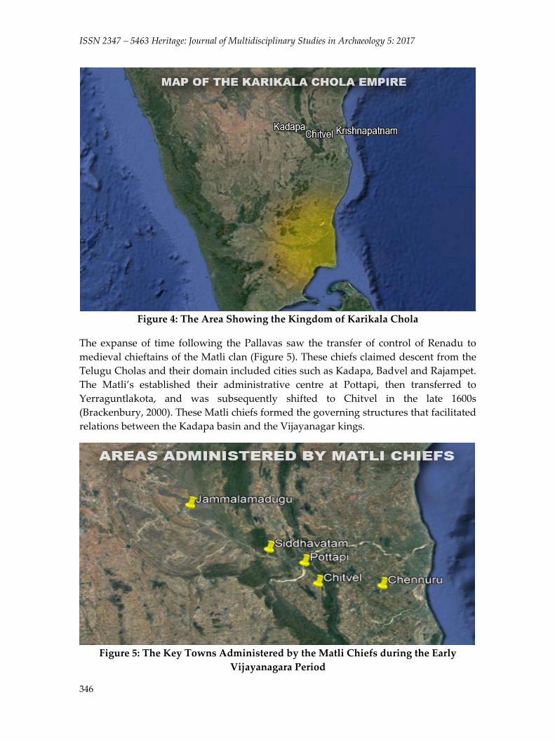
legendary king, Karikala Chola (Chetty, 1984). However, no evidence indicates the
presence of their putative ancestors in Chitvel nor in Krishnapatnam (Figure 4). The
records of the Buddhist pilgrim Xuanzang describes the Chuliyas (Cholas) of Renadu as
a fierce people (Reddy, 1999). Xuanzang’s observations may indicate the development
of a cultural mentality in response to constant warfare. This conflict with neighboring
powers led the Telugu Cholas of Renadu to eventually meet their defeat at the hands of
the Pallavas. These Cholas eventually began establishing new territories farther north
towards Pottapi (Narasimham, 1984).
Figure 3: The Territory of Renadu
ISSN 2347 – 5463 Heritage: Journal of Multidisciplinary Studies in Archaeology 5: 2017
346
Figure 4: The Area Showing the Kingdom of Karikala Chola
The expanse of time following the Pallavas saw the transfer of control of Renadu to
medieval chieftains of the Matli clan (Figure 5). These chiefs claimed descent from the
Telugu Cholas and their domain included cities such as Kadapa, Badvel and Rajampet.
The Matli’s established their administrative centre at Pottapi, then transferred to
Yerraguntlakota, and was subsequently shifted to Chitvel in the late 1600s
(Brackenbury, 2000). These Matli chiefs formed the governing structures that facilitated
relations between the Kadapa basin and the Vijayanagar kings.
Figure 5: The Key Towns Administered by the Matli Chiefs during the Early
Vijayanagara Period

Desai and Mathur 2017: 343‐356
347
Siddhavattam Fort The Matli chiefs governing Chitvel constructed Siddhavattam Fort along the Pennar
River approximately during the time of the Early Vijayanagar Empire. Siddhavattam
holds prominence from ancient times where the temple of Siddheswara was built by
the Cholas. Even prior to the construction of the fort, the location held prominence as a
pilgrimage site (Sivaiah, 2011). The area chosen for the construction of Siddhavattam
Fort is rather distant from Chitvel, and was likely chosen due to the area’s importance
to the local culture.
Renadu later became a dependency of the Vijayanagara Empire that was continually
administered by the Matli chieftains. During this period of time, Siddhavattam Fort
provided the Matli chiefs with an excellent vantage point along the Ballari‐
Krishnapatnam trade route (Figure 6). The abovementioned route BKr1 (see Figure 1)
was the earlier route includes the fort of Siddhavattam implying that it may have
served as a checkpoint or a location for the assemblage and redistribution of goods
(Figure 7). Siddhavattam allowed the Matli chiefs to benefit from trade within the
Vijayanagar Empire.
Figure 6: The Location of Chitvel with Reference to Siddhavatam
The first dynasty of Vijayanagar saw the rise of iron metallurgy in the Kadapa basin.
Most of the area’s iron working aimed at creating implements for use in agriculture.
This was accomplished through the use of ores mined from the veins of the Kadapa
series. Chitvel taluka housed several furnaces used to mix ores from the Kadapa series
with lateritic ore (Ball, 1881). In the Rayalseema (between the mouths of the Krishna

ISSN 2347 – 5463 Heritage: Journal of Multidisciplinary Studies in Archaeology 5: 2017
348
and Pennar Rivers) region, metal workers, such as blacksmiths, bronze‐smiths, and
goldsmiths, and carpenters formed the Panchamavaru castes which are presently
known as the Vishwakarmas who now trace their lineage to Vishwabrahma or the
Brahmin community. Iron production in Kadapa district intensified the area’s
importance to trade.
Figure 7: Inside Siddhavattam Fort
The rule of Devaraya in Vijayanagar is commonly associated with an emphasis on
policies to boost trade by land and sea. According to the inscription found in
Donyalasani (Siddhavatam taluk), Devaraya exempted craftspeople from all the taxes
(Narasimham, 1984). An inscription at Siddhavattam only further emphasizes the
importance of the fort as a centre for professional artisans and trade related activities
(Figure 7). Persian Ambassador Abdul Razzaq mentions about 360 active ports in
South India alone during the reign of Devaraya (Alam & Subrahmaniyam, 2011), many
of which are only accessible via passage through the Kadapa basin. Kathleen Morrison
(1997) characterises this time period as one of developing urbanism, long‐distance
volatile economic‐political relationships, and increased market‐based production. By
exempting metallurgists from taxes, Devaraya boosted the economic value of Chitvel
taluka in an increasingly competitive economic system.
Siddhavattam Fort illustrates the importance of connecting Kadapa to Nellore through
the southern Velikondas. Such a route would have allowed the Matli chiefs to increase
their ability to profit from the area’s increasing trade during the Vijayanagar Empire.
The conquest of the Chittiveli Kuppa (Figure 8) by the Renadu chiefs (Reddy, 1999)
might also indicate such a path through Velikondas, in order to enhance

Desai and Mathur 2017: 343‐356
349
communications between the ports of the eastern coast and Siddhavattam Fort. Such a
passage would have provided Chitvel quick access to the densely populated markets
located on the southern coast of Andhra Pradesh.
Figure 8: The Red Marker Shows the Location of the Chittiveli Kuppa
(Kuppa Standing for a heap/mound in Telugu)
The Trade Centres of Renadu and the Ports of Trade The eastern coast of Andhra Pradesh served a gateway to maritime trade for the past
two millennia. Although the exact history of ports of Krishnapatnam and
Durgarajapatinam (district Nellore) is unknown (Narasimham, 1984), it is certain that
this area has been occupied by large, complex societies since early historic times.
Previous studies in the region yielded several Duvvuru silver punch‐marked coins,
Ikshvaku coins, and sherds of Northern Black Polished Ware, indicating the presence
of the Mauryan Empire at Krishnapatnam (Radhakrishna Reddy, 2004).
Durgarajapatinam port serves as a larger port and stands on the shores of Pulicat. The
port of Krishnapatnam and other smaller ports of Nellore acted as the feeders to
Durgarajapatinam during pre‐British times (The distance between the northernmost
point of Nellore to Madras would be around 120 miles and region had good ports
mostly used for coastal trade carrying diverse merchandise such as grain, Indigo, and
textiles. RFSG, Letters to Fort St. George, 1711.) This region between the Pennar and
the Krishna were invaluable to maritime trade in the east coast and comprised a region
known as Rayalseema.
Jaina remains recovered from the Badvel‐Nellore route (G.K. Murthy, 1963) signify the
presence of Jainas along this path. Singh (2008) argues that the decline in trade in
Andhra Pradesh and Karnataka between the fifth and ninth centuries CE is due to the
lack of Jaina merchants. However, the Chinese pilgrim Xuanzang mentions the
presence of a high population of Jainas in the Renadu region during this time (V.N.
ISSN 2347 – 5463 Heritage: Journal of Multidisciplinary Studies in Archaeology 5: 2017
350
Reddy, 1999). Therefore rendering the possibility of their absence being a cause of
decline unlikely.
Alternatively, major trade guilds, such as Ayyavolu played a monumental role in the
region’s trade relations. The Ainurruvar, or the guild of 500 Lords of Ayyavolu, trace
their ancestry to Aihole, and comprised groups of various merchants and craftsmen
from a wide array of specialisations such as pottery, goldsmithery, weaving and the
trade of exotic and luxury goods (Kulke et. al, 2009). The presence of such trade guilds
at Rayalseema allowed both the producers and distributors of goods to play key roles
in managing the various economies of the region.
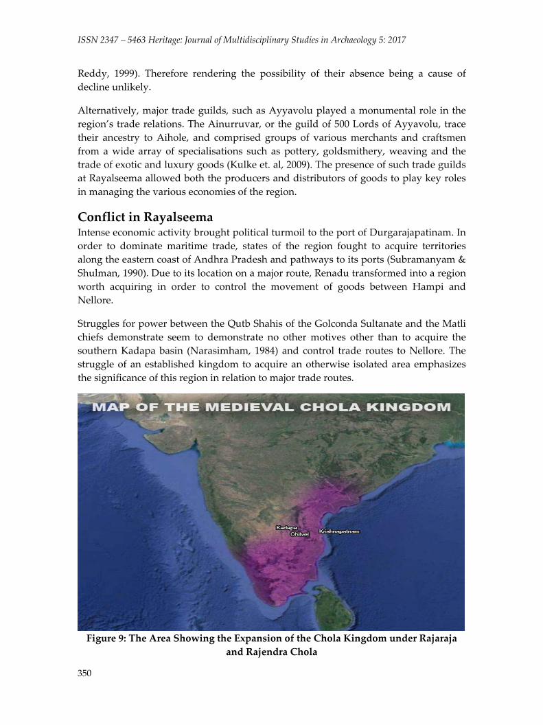
Conflict in Rayalseema Intense economic activity brought political turmoil to the port of Durgarajapatinam. In
order to dominate maritime trade, states of the region fought to acquire territories
along the eastern coast of Andhra Pradesh and pathways to its ports (Subramanyam &
Shulman, 1990). Due to its location on a major route, Renadu transformed into a region
worth acquiring in order to control the movement of goods between Hampi and
Nellore.
Struggles for power between the Qutb Shahis of the Golconda Sultanate and the Matli
chiefs demonstrate seem to demonstrate no other motives other than to acquire the
southern Kadapa basin (Narasimham, 1984) and control trade routes to Nellore. The
struggle of an established kingdom to acquire an otherwise isolated area emphasizes
the significance of this region in relation to major trade routes.
Figure 9: The Area Showing the Expansion of the Chola Kingdom under Rajaraja
and Rajendra Chola

Desai and Mathur 2017: 343‐356
351
Figures 4 and 9 compare the extent of the Chola empire from the reign of Karikala
Chola in the early century CE vs. the early medieval period Chola territory. The extent
of Chola empire in Figure 9 denotes the addition of the entire south‐eastern coast of
peninsular India to the empire as well as the entire Rayalseema and coastal Andhra
regions. The study area comprising the Kadapa‐Chitvel‐Krishnapatnam route was
likely developed as a result of the Chola Kings in early medieval Andhra.
During times of intense conflict, traders that migrated to Rayalseema along with
warrior communities gained control of the port towns and markets. These prestigious
positions promised them higher political status in the courts of the kings to whom they
pledged allegiance (These merchants were involved in revenue farming, governing
certain provinces etc., apart from trade which was their main economic activity. On the
careers of Mallaya and Chinnana, See, Joseph J. Bren). Vijayaditya, the immediate
successor of Pulakesin II, established numerous agraharas and increased the economic
resources of Rayalseema (Narasimham, 1984). This was also precisely the time the
Ayyavolu lords became a major trading power and established its presence in
Rayalseema.
Evidence of Outside Activity at Chitvel Thomas Munro, while on visit to Kadapa during the rule of Nawab Abdul Nabi Khan
in 1801, states that the Matli chiefs obtained Chitvel ninety years before his time. This,
he describes, was in order to pay the tributes to the Nawabs after Haidar’s conquest of
Kadapa. It appears that the town of Chitvel was of little importance to the Nawabs of
Kadapa.
Chitvel features an old town clustered behind new establishments which have
development along the State Highway 58, connecting Gudur to Rajampet via Chitvel
further to Gudur‐Pullampet and Nellore and Rapur to Rajampet. The region
demonstrates the presence of an agraharam that starkly contrasts with the local
vernacular tantric cults. The establishment of this agraharam is attested in an 1806
inscription describing the bequeathal of land by Jagirdar Jaikishen Rao to an
agraharam in Chitvel taluka. (Sastry, 1981).
Then inhabitants of Chitvel erected tantric stones (see Figure 10) along the
northwestern road across the bank of the Cheyyeru River, surrounded by temples.
These stones are inscribed with symbols in red and orange pigment and serve to
spiritually represent local goddesses that engage with residents during ceremonies and
times of need. Similar tantric cultures are also present in the nearby areas of Rajampet
and Nandalur. Tantric culture may be a feature of ancient Chitvel that has endured
throughout the years.
The vestiges of medieval activity are clearly visible at a particular temple dedicated to
the Tamil deity, Varadaraja Swamy (Figure 14). The temple dedicated to Varadaraja, a
strong Vishnu cult that saw its popularisation around the region of Kanchipuram in

ISSN 2347 – 5463 Heritage: Journal of Multidisciplinary Studies in Archaeology 5: 2017
352
Tamil Nadu. The shrine dedicated to Garuda is facing the main temple. It is to be
noticed that the shrine of Garuda has a shikhara that resembles stylistically to the
Chola architecture (Figure 11). This adds the probability of the temple being
constructed by the Cholas or under the patronage of Cholas during the medieval
centuries further enhancing the importance of the area. The temple structure (Figure
12) itself is rather small, and plain in its design (Figure 13) but features an entrance
adorned with a Gopuram (see Figure 14) that matches the architectural style of the
Vijayanagar Empire. The presence of a Vijayanagar style Gopuram at an otherwise
ordinary temple illustrates an attempt to modify the appearance of the temple
structure to bypassers. This contrasts with an attempt to modify the temple structure
itself via additions to the interior or modifications to the exterior portions. The
Varadaraja Swamy temple and another nearby temple dedicated to Veerabhadra and
Bhadrakali represent cult ideologies that flourished under the Vijayanagar
administration (Verghese, 1995). The establishment of these temples signifies the
proximity of Chitvel to medieval trade centres and may imply the existence of an
additional route to Nellore district, due to the location of the Chitvel in relation to the
original routes.
Figure 10: Tantric Stone at Chitvel

Desai and Mathur 2017: 343‐356
353
Figure 11: The Garuda Shikhara Stylistically Resembling the Chola Architecture
Figure 12: Temple Grounds of the Varadaraja Swamy Temple

ISSN 2347 – 5463 Heritage: Journal of Multidisciplinary Studies in Archaeology 5: 2017
354
Figure 13: The View of the Varadaraja Swamy Temple from the Gopuram
Figure 14: Vijayanagar Gopuram at the Varadaraja Swamy Temple

Desai and Mathur 2017: 343‐356
355
The temple sits inside of a large walled complex that is mostly empty. The size of the
walled complex compared to the temple itself suggests a different intended use for the
area during the time of the construction of the compound walls (Figure 10 and Figure
15). Although further evidence is required in order to establish an explanation for this
arrangement, it appears that the temple is the correct size for accommodating groups
of travelers. The practice of housing royal camps in large walled areas is common
throughout the region, including in later times. However, due to a lack of evidence, the
exact purpose of the temple grounds cannot be explained.
Figure 15: Empty Temple Grounds at Chitvel
Close to the Varadaraja Swamy temple adjacent to the state highway 58, lie three
rudimentary hero stones. Though the three hero stones give only a observatory
information on the dynasty/cattle warfare or the time‐space context, itʹs essential to
note that the erection of hero‐stones and the hero worship was not popularised before
the rise of Vaidumbas in the Kadapa region (Narasimham 1984). Chitvel’s spiritual and
religious infrastructure yields much evidence for interactions with many different
cultures from outside the Kadapa basin.
Conclusion The presence of the Vijayanagar‐style Gopuram at the Varadaraja Swamy Temple in
Chitvel village demonstrates the patronage of this isolated taluka headquarters to the
Vijayanagar Empire. Although the Public Works division of the Madras Presidency
built the road to Nellore (and by extension, Krishnapatnam) via Chitvel quite recently,
the intense activity on both sides of the Kadapa basin suggests the need for routes to
the eastern coast. This may indicate the presence of a pre‐British road across the
Velikondas through Chitvel.
ISSN 2347 – 5463 Heritage: Journal of Multidisciplinary Studies in Archaeology 5: 2017
356
This, however, in retrospection is also important route for Siddhavatam Fort which
was ruled by the same Matli chiefs who had their seat at Chitvel. Although, the early
historical importance of Chitvel is unclear, the emergence of consolidated trade and
trade guilds in Andhra may have enacted the regulation of passages both major and
minor throughout the region. A few nomadic metallurgical activities, and multiple
inscriptions found in the nearby towns of Rajampet, Nandalur and Siddhavatam, gives
Chitvel some prominence as it lies in close proximity and shares political and cultural
perspectives. The taluka also serves as a natural line of defence against any kingdom
lying east or west of Kadapa and serves as a natural frontier for the southern side of
Siddhavatam Fort as well. The sequestered village of Chitvel lies in the middle of an
important pathway between major urban centres during medieval times.
References Alam, Muzaffar and Sanjay Subrahmanyam. 2011. Writing the Mughal World: Studies on
Culture and Politics. New York, NY: Columbia University Press.
Ball, V. 1881. A Manual of the Geology of India: Part III Economic Geology. Calcutta:
Geological Society of India.
Brackenbury, C. F. 2000. Madras District Gazetteers: District Gazetteer: Cuddapah.
Chennai: Asian Educational Services. original work published in 1915.
Kulke, Hermann, K. Kesavapany, and Vijay Sakhuja Eds.. 2009. Nagapattinam to
Suvarnadwipa: Reflections on Chola Naval Expeditions to Southeast Asia.
Singapore: Institute of Southeast Asian Studies.
Kumar, K. Kiran. 2012. Land and Village Grants in Andhra. Sri Venkateswara University.
Tirupati, Andhra Pradesh.
Morrison, Kathleen D. 1997. “Commerce and Culture in South Asia: Perspectives from
Archaeology and History.” Annual Review of Anthropology, 26: 87‐108.
Narasimham, A. 1984. Cultural History of Rayalsima From the Earliest to 1565 A.D. Sri
Venkateswara University. Tirupati, Andhra Pradesh.
R. B. P. Singh 2008 Jainism in Early Medieval Karnataka. Delhi: Motilal Banarsidass
Publishers.
Reddy, B. Radhakrishna. 2004. Nellore Through the Ages. Sri Venkateswara University.
Tirupati, Andhra Pradesh.
Reddy, C. Srinivasa. 2011. Factories and Ports in India: a study of the English settlement
pattern on the Coromandel Coast 1630‐1724. University of Hyderabad.
Hyderabad, Telangana.
Reddy, M. Venkata Narayana. 1999. Renadu: A Study of Society from the 6th Century to the
17th Century A.D. Sri Venkateswara University. Tirupati, Andhra Pradesh.
Sastry, Parabrahma P.V. 1981 Inscriptions Of Andhra Pradesh, Cuddapah District,Part III,
Series Epigraphical No. 15, Government of Andhra Pradesh, Hyderabad.
Sivaiah, Peram. 2011. Vijayanagara Forts in Rayalseema: A Study. Sri Venkateswara
University. Tirupati, Andhra Pradesh.
Verghese, Anila. 1995. Religious Traditions at Vijayanagara as Revealed Through its
Monuments. New Delhi: American Institute for Indian Studies.