MCE GeoProcessing Services for ADM(IE): Self Validation of Spatial Data Input from DND Bases
21
ADM(IE) Real Property Spatial Information Management MCE GeoProcessing Services for ADM(IE): Self Validation of Spatial Data Input from DND Bases FME World Tour 2015 – Ottawa 15 April 2015 Martin de Zuviria (GIS Architect, MCE) Paul Churcher (DAES IMS GIS Coordinator, ADMIE)
-
Upload
safe-software -
Category
Technology
-
view
230 -
download
0
Transcript of MCE GeoProcessing Services for ADM(IE): Self Validation of Spatial Data Input from DND Bases

ADM(IE) Real Property Spatial Information Management
MCE GeoProcessing Services for ADM(IE):
Self Validation of Spatial Data Input from DND Bases
FME World Tour 2015 – Ottawa
15 April 2015
Martin de Zuviria (GIS Architect, MCE)
Paul Churcher (DAES IMS GIS Coordinator, ADMIE)

2
Introduction
ADM(Infrastructure and Environment) Mission is to provide IE
functional leadership and services to enable effective,
efficient and sustainable management of DND
infrastructure and environment in support of CAF missions
and Departmental programs.
ADM(IE) will have sole custodial authority by 01 Apr 2016 over
all DND Real property (RP) assets.
Responsible for:
• Over 2 million hectares of owned/leased land
• Over 20,000 buildings
• Over 13,000 works items (docks, jetties, runways, etc)
• Real property nationwide in every province and territory

3
A proof-of-concept has been completed that shows the benefits of standardized and centralized real property spatial data.
• A proof-of-concept collaboration with MCE, a centre of excellence for spatial data, has proven that open standards applied to a Real Property Spatial Data Warehouse (RPSDW) promotes integration and interoperability of CAD/BIM/GIS spatial data.
• The data model supports portfolio-wide analysis and query.
• Next steps
− Expand the data model to include all real property spatial data.
− Operationalize the warehouse through a graduated data maturity model.
− Collaborate with bases/wings on data management best practice for keeping the warehouse current.
− Provide documented schema for the integration of particular data to SAP and vice versa.
− Provide information service to ADM(IE) stakeholders through web services, data delivery and integration.
Real Property Spatial Information Management
D A T A C E N T R A L I Z A T I O N

4
Integration of spatial data between the RPSDW and corporate systems enables single-entry of data.
• SAP holds master data (attribution) on built and natural assets required for mapping and site engineering.
• Spatial data holds point-of-truth information such as measurement, age and geo-location for other corporate systems.
• Integrating this attribute information to/from SAP will eliminate the current dual entry process.
• Information will be updated automatically as changes are reflected in the originating systems.
• Information required to provide spatial services will be integrated to the RPSDW from SAP.
• Other corporate systems can benefit from data integration such as project delivery, plant maintenance, facilities management and energy auditing.
Real Property Spatial Information Management
D A T A I N T E G R A T I O N

5
ADM(IE) manages real property spatial spatial data for site infrastructure & utilities, buildings and land registry which includes:
• Civil Works Models
• CAD Site and Building Plans
• Building Information Models
• GIS Views
• Photographs
• Land Imagery
• Terrain Models
• Environmental
• Boundary Survey
• Site Survey
• LiDAR Survey
Key attribute data for project delivery and ongoing real property management is exchanged between SAP and the spatial warehouse, enhancing overall accessibility.
RP Spatial Data - Types

6
RP Spatial Data Staged Maturity
Land
Registry
The RPSDW data maturity model will
provide a graduated, predictable
transition from a decentralized to a
centralized and integrated RP spatial
data environment.

7
RP Spatial Data Staged Maturity - Example

8
RP Spatial Data Staged Maturity - Example

9 9
Self Validation of Spatial Data Input from DND Bases
Summary
The FME workspace presented here is part of a joint project between the Mapping and
Charting Establishment (MCE) and the Assistant Deputy Minister for Infrastructure and
Environment (ADM(IE)). This project involves managing DND real property and other spatial
data provided by DND Bases across Canada at MCE through a unique, integrated and
standardized Real Property Spatial Data Warehouse (RPSDW) containing a SQL Server
database.
Data provided by DND Bases must meet the standards defined and documented by ADMIE, in
terms of data formats accepted (GeoMedia MDB, ArcGIS FGDB, MapInfo MIF and AutoCAD
SDF), schema and attribute data types, domains and accepted values for each feature class.
An FME workspace and an equivalent tool contained within an ArcGIS Data Interoperability
Toolbox were created to provide the GeoTechs from DND Bases using ArcGIS Data
Interoperability or FME Desktop with a toolset, delivered together with a user’s guide, that
allows them to perform a self validation of the DND real property and other spatial data
before these data is sent to MCE to be loaded into the RPSDW SQL Server database.
The FME workspace presented here outputs all errors, warnings and non-compliance issues
to a destination FGDB, and is followed at MCE by other workspaces to ensure proper data
management of the SQL Server database and communication with DND Bases.

ADMIE Standards: Feature Classes, attributes and
properties defined and documented

11
Overview of the Self-Validation ETL

Navigator: Input, Output and Bookmarks. Standards are used to
validate schema compliance of any feature class input against them

13
A similar sequence of bookmarks implemented for the P_Building feature class is being applied to the
other 26 selected feature classes
14
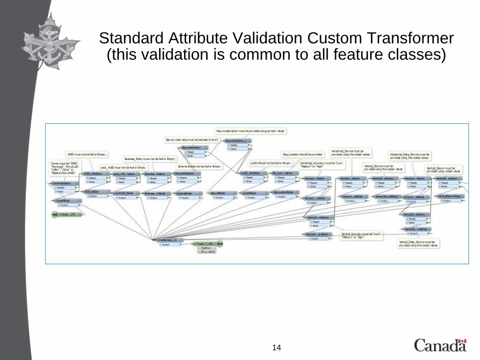
Standard Attribute Validation Custom Transformer (this validation is common to all feature classes)
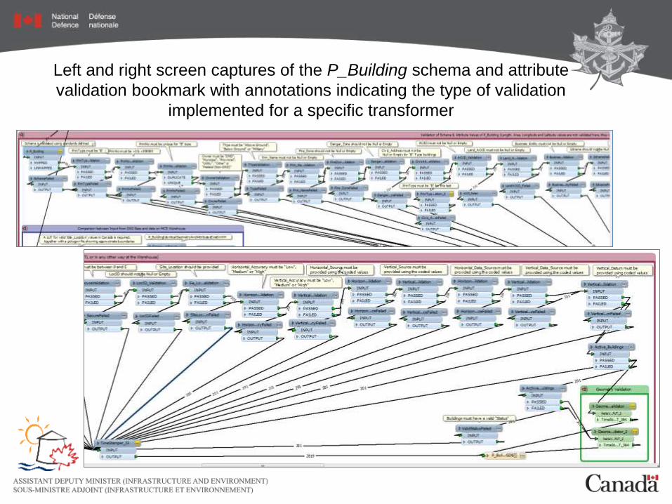
Left and right screen captures of the P_Building schema and attribute
validation bookmark with annotations indicating the type of validation
implemented for a specific transformer

16
Geometry Validation Custom Transformer

17
Comparison between input from Bases and data on MCE
Warehouse Bookmark (buildings geometry and all attribute values
defined in the standard schema are compared)

18
Errors and Warnings are reported in two FGDBs: In the first FGDB a single feature may be output several times showing
only one error at a time (one error – one record) ; On the second FGDB a single feature may be output only once,
reporting all errors together

19
Overview of the QA_ETL_Aggregated_Output FGDB

20
Data InspectionThe example below shows on the ‘Table View’ that a ‘PRIN_TYPE’ value is
missing for a building , that there are duplicate ‘Prin_No’ values, ‘Type’ values have not been provided, together with other 2819 errors identified for this
dataset. These errors should be corrected in the Bases before loading these data to MCE warehouse
21
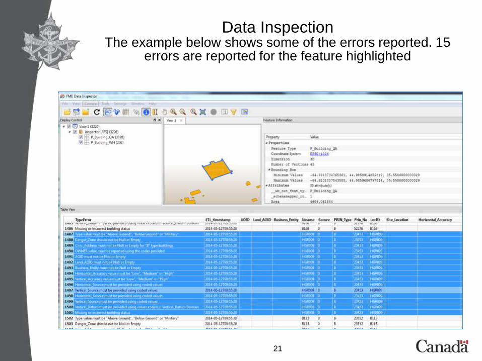
Data InspectionThe example below shows some of the errors reported. 15
errors are reported for the feature highlighted