Maynooth to Westmeath Border Shared Cycleway &...
27
Maynooth to Westmeath Border Shared Cycleway & Footway (38km) HABITATS DIRECTIVE ASSESSMENT – SCREENING REPORT April 2013 Consulting Engineer Roughan & O’Donovan – AECOM Alliance Arena House Arena Road Sandyford Dublin 18 Client Meath County Council County Hall Navan County Meath
Transcript of Maynooth to Westmeath Border Shared Cycleway &...

Maynooth to Westmeath Border Shared Cycleway & Footway (38km)
HABITATS DIRECTIVE ASSESSMENT –
SCREENING REPORT
April 2013
Consulting Engineer Roughan & O’Donovan – AECOM Alliance Arena House Arena Road Sandyford Dublin 18
Client Meath County Council County Hall Navan County Meath

ROD-AECOM Alliance Maynooth to Westmeath Border Shared Cycleway and Footway Consulting Engineers Meath County Council/Kildare County Council
Ref: 12221.24/HDA April 2013 Page iii
Maynooth to Westmeath Border Shared Cycleway & Footway (38km)
Habitats Directive Assessment –
Screening Report
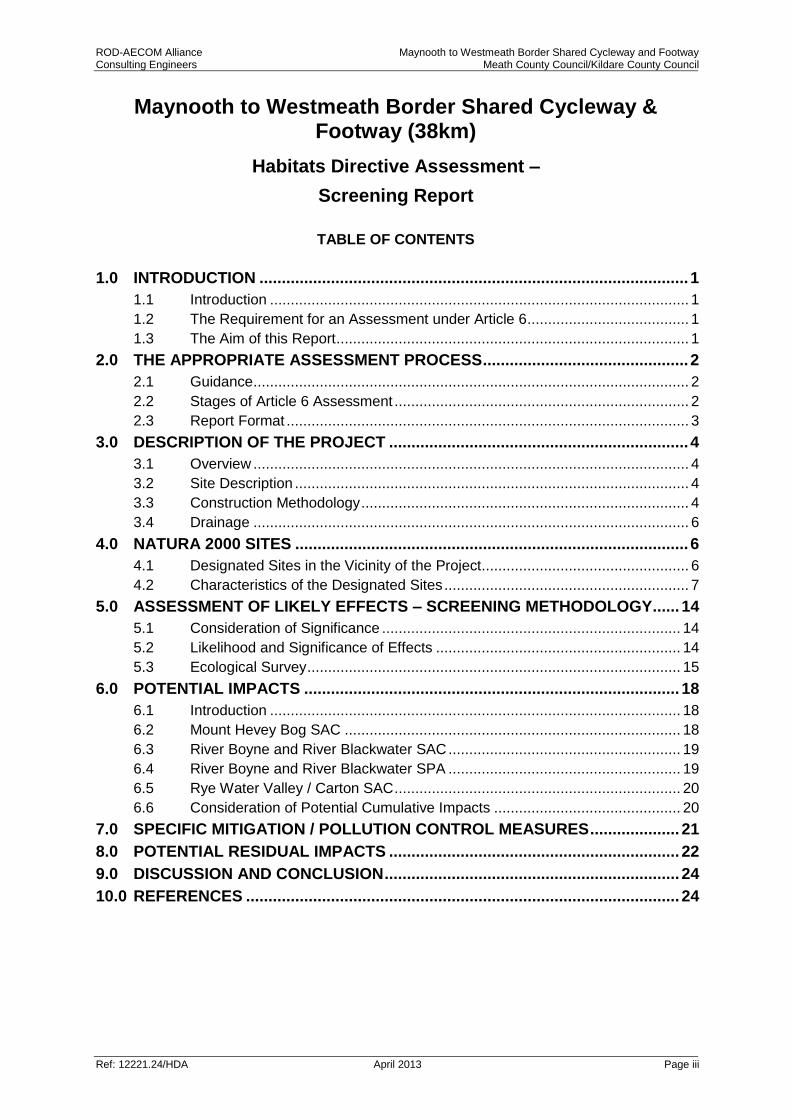
TABLE OF CONTENTS
1.0 INTRODUCTION ................................................................................................ 1
1.1 Introduction ..................................................................................................... 1
1.2 The Requirement for an Assessment under Article 6 ....................................... 1
1.3 The Aim of this Report ..................................................................................... 1
2.0 THE APPROPRIATE ASSESSMENT PROCESS .............................................. 2
2.1 Guidance ......................................................................................................... 2
2.2 Stages of Article 6 Assessment ....................................................................... 2
2.3 Report Format ................................................................................................. 3
3.0 DESCRIPTION OF THE PROJECT ................................................................... 4
3.1 Overview ......................................................................................................... 4
3.2 Site Description ............................................................................................... 4
3.3 Construction Methodology ............................................................................... 4
3.4 Drainage ......................................................................................................... 6
4.0 NATURA 2000 SITES ........................................................................................ 6
4.1 Designated Sites in the Vicinity of the Project .................................................. 6
4.2 Characteristics of the Designated Sites ........................................................... 7
5.0 ASSESSMENT OF LIKELY EFFECTS – SCREENING METHODOLOGY ...... 14
5.1 Consideration of Significance ........................................................................ 14
5.2 Likelihood and Significance of Effects ........................................................... 14
5.3 Ecological Survey .......................................................................................... 15
6.0 POTENTIAL IMPACTS .................................................................................... 18
6.1 Introduction ................................................................................................... 18
6.2 Mount Hevey Bog SAC ................................................................................. 18
6.3 River Boyne and River Blackwater SAC ........................................................ 19
6.4 River Boyne and River Blackwater SPA ........................................................ 19
6.5 Rye Water Valley / Carton SAC ..................................................................... 20
6.6 Consideration of Potential Cumulative Impacts ............................................. 20
7.0 SPECIFIC MITIGATION / POLLUTION CONTROL MEASURES .................... 21
8.0 POTENTIAL RESIDUAL IMPACTS ................................................................. 22
9.0 DISCUSSION AND CONCLUSION .................................................................. 24
10.0 REFERENCES ................................................................................................. 24
ROD-AECOM Alliance Maynooth to Westmeath Border Shared Cycleway and Footway Consulting Engineers Meath County Council/Kildare County Council
Ref: 12.221.24/HDA April 2013 Page 1
1.0 INTRODUCTION
1.1 Introduction
Roughan & O’Donovan – AECOM Alliance were appointed to undertake the preliminary design and detailed design of the Westmeath / Meath county boundary to Maynooth Cycle Way. This report has been prepared to determine the potential effects, if any, of the proposed scheme on nearby sites with European conservation designations (i.e. Natura 2000 sites). The purpose of this assessment is to determine the appropriateness, or otherwise, of the proposal in the context of the conservation status of such sites. The proposed Maynooth to Westmeath Border Shared Cycleway & Footway is a 38 km segment of a proposed cycle and pedestrian facility between Maynooth and Mullingar. The first Phase between Mullingar and the Westmeath / Meath county boundary was subject to a Part VIII Planning Application which was submitted and approved in 2012. This proposal was screened out for Appropriate Assessment with a conclusion of no likely significant effects on Natura 2000 sites (‘Finding of no Significant Effects’). A report supporting the screening conclusion was submitted as part of the Part VIII application for the development. The Mullingar to the Westmeath/Meath county boundary cycleway is currently under construction. Part II of the Maynooth to Mullingar Cycle Way aims to continue the route from Westmeath / Meath county boundary to Maynooth for a distance of 38km. The Proposed cycle route network aims to feed into the local and national tourism strategy by creating a tourism product which complements the existing natural, cultural and built heritage along the route. The cycle route has been identified as a significant marketing tool in the promotion of Ireland as a cycle destination and as part of the greater trans-European cycle route: EuroVelo 2: Capitals Route from Galway though the UK, Netherlands, Germany, Poland, Belarus and Russia as far as Moscow.
1.2 The Requirement for an Assessment under Article 6
The requirement for Appropriate Assessment is set out in the EU Habitats Directive (92/43/EEC) in Article 6 (3) which states:
“Any plan or project not directly connected with or necessary to the management of the [Natura 2000] site but likely to have a significant effect thereon, either individually or in combination with other plans and projects, shall be subjected to appropriate assessment of its implications for the site in view of the site’s conservation objectives.”
The Habitats Directive is transposed in Ireland by the European Communities (Birds and Natural Habitats) Regulations, 2011 (consolidating the European Communities (Natural Habitats) Regulations 1997 to 2005 and the European Communities (Birds and Natural Habitats) (Control of Recreational Activities) Regulations 2010, as well as addressing transposition failures identified in recent CJEU Judgements) (hereafter referred to as the Habitats Regulations) and the Planning and Development (Amendment) Act, 2010.
1.3 The Aim of this Report
This Screening for Appropriate Assessment (Stage 1) has been prepared in accordance with current guidance and provides an ecological impact assessment for the proposed scheme.

ROD-AECOM Alliance Maynooth to Westmeath Border Shared Cycleway and Footway Consulting Engineers Meath County Council/Kildare County Council
Ref: 12.221.24/HDA April 2013 Page 2
The Screening provides the information required in order to establish whether or not the proposed development is likely to have a significant impact on the Natura sites in the context of their conservation objectives and specifically on the habitats and species for which the Natura 2000 sites have been designated. By undertaking the ecological impact assessment in a step by step manner in relation to the habitats and species of the Natura 2000 sites, this report seeks to inform the screening process required as the first stage of the process pursuant to Article 6.3 of the EU Habitats Directive. Proposed Natural Heritage Areas (pNHA) are sites of national significance that have been proposed but not yet formally designated. When formally designated an NHA is legally protected from damage under Irish legislation in the form of the Wildlife (Amendment) Act 2000. However, as this Screening for Appropriate Assessment report deals only with Natura 2000 sites the pNHAs are not considered further in this study, other than in the description of the study area.
2.0 THE APPROPRIATE ASSESSMENT PROCESS
2.1 Guidance
Article 6(3) of the EU Habitats Directive (92/43/EEC) defines the requirement for Appropriate Assessment of certain plans and projects. In order to inform the requirements of this Screening Report the following guidance documents have been referred to:
Appropriate Assessment of Plans and Projects in Ireland - Guidance for Planning Authorities. (Department of Environment, Heritage and Local Government, 2010 revision);
Appropriate Assessment under Article 6 of the Habitats Directive: Guidance for Planning Authorities. Circular NPWS 1/10 & PSSP 2/10;
Assessment of Plans and Projects Significantly Affecting Natura 2000 sites: Methodological Guidance on the Provisions of Article 6(3) and (4) of the Habitats Directive 92/43/EEC;
Managing Natura 2000 Sites: The Provisions of Article 6 of the Habitat’s Directive 92/43/EEC (EC Environment Directorate-General, 2000);
Guidance Document on Article 6(4) of the Habitats Directive 92/43/EEC. Clarification of the Concepts of Alternative Solutions, Imperative Reasons of Overriding Public Interest, Compensatory Measures, Overall Coherence. Opinion of the European Commission (European Commission, January 2007).’
2.2 Stages of Article 6 Assessment
The European Commission’s guidance promotes a staged process, as set out below, the need for each being dependent upon the outcomes of the proceeding stage.
(1) Screening
(2) Appropriate Assessment
(3) Assessment of Alternative Solutions
(4) Assessment where no alternative solutions remain and where adverse impacts remain.

ROD-AECOM Alliance Maynooth to Westmeath Border Shared Cycleway and Footway Consulting Engineers Meath County Council/Kildare County Council
Ref: 12.221.24/HDA April 2013 Page 3
The “IROPI test” (Imperative Reasons of Over-riding Public Interest) and compensatory measures.
The Habitats Directive promotes a hierarchy of avoidance, mitigation and compensatory measures. Stage 1 of the process is intended to identify whether the project is ‘likely to have a significant effect’ upon a European site, referred to as ‘Screening for Appropriate Assessment’. If the screening process identifies effects to be significant, potentially significant or uncertain, or if the screening process becomes overly complicated, then the process must proceed to Stage 2 (AA). Screening is undertaken without the inclusion of mitigation, unless potential impacts clearly can be avoided though the modification or redesign of the plan or project, in which case the screening process is repeated on the altered plan. The greatest level of evidence and justification will be needed in circumstances when the process ends at screening stage on grounds of no impact. Section 177U of the Planning and Development Act 2010 states that the competent authority shall determine that an appropriate assessment of the proposed development is not required if it can be excluded, on the basis of objective information, that the proposed development, individually or in combination with other plans or projects, will not have a significant effect on a European site. Stage 2 of the process considers any potential impacts in greater detail including whether further mitigation measures are required. If an adverse impact upon the site’s integrity cannot be ruled out then Stage 3 will need to be undertaken to assess whether alternative solutions exist. If no alternatives exist that have a lesser effect upon the Natura 2000 site/s in question, the project can only be implemented if there are ‘imperative reasons of overriding public interest’, as detailed in Article 6(4). In essence, the work at Stage 1 will determine whether further stages of the process are required. This report includes the testing required under Stage 1: Screening for Appropriate Assessment.
2.3 Report Format
This Screening Report includes the assessment and testing required under Stage 1 – the Screening Process. In complying with the obligations under Article 6(3) and to be consistent with the Guidance for Planning Authorities, this report has been structured as follows:
Description of the Plan/Project;
Identification of Natura 2000 sites, and the associated Conservation Objectives, which may be potentially affected;
Identification and description of individual and cumulative impacts likely to result from the Plan/Project;
Assessment of the significance of the impacts identified above on site integrity. Exclusion of site where it can be objectively concluded that there will be no significant effects.

ROD-AECOM Alliance Maynooth to Westmeath Border Shared Cycleway and Footway Consulting Engineers Meath County Council/Kildare County Council
Ref: 12.221.24/HDA April 2013 Page 4
3.0 DESCRIPTION OF THE PROJECT
3.1 Overview
The proposed greenway is to provide a safe environment for tourists and local users to cycle adjacent to the Royal Canal by providing a 3m wide cycle track which for the majority of its length is separated from live vehicular traffic between the county boundary and Maynooth. See Part VIII Drawing No’s 12221-001 to 12221-011 for a detailed description of the proposed design.
3.2 Site Description
The Maynooth to Westmeath Border Shared Cycleway & Footway is to be located along the Royal Canal for its entire length. The Royal Canal is designated as a proposed Natural Heritage Area (pNHA). The proposed upgrading of this part of the Royal Canal towpath to a cycleway runs from the Westmeath /Meath county boundary to the Harbour in Maynooth for approximately 38km.
The route of the towpath runs the length of the Royal Canal from the county boundary across the River Boyne at Boolkeagh and though Enfield and Kilcock to the Harbour at Maynooth. The route is made up of a combination of existing local and access roads and the Royal canal towpath which consists of occasional scrub, bound and unbound surfaces occasionally covered in grass. The towpath was formerly used by horses to pull barges along the canal but is now more typically used by walkers, for fishing and as an access road in some places. The towpath is approximately 2-5m wide and alternates between grassy tracks to gravel surfaces. In most areas the canal bank is colonised by aquatic vegetation while hedgerows, tree lines and scrub form the boundary habitat.
3.3 Construction Methodology
The proposed cycle route is to be located on the existing tow path which varies in width and surface type. Where the existing tow path consists of a grass bank a thin layer of topsoil is to be removed to form a formation layer where the proposed cycle path will be constructed. However significant sections of the route are made up of existing bound and unbound surfaces. There are three main methods of construction which are to be implemented depending on local conditions: Quarry Dust The majority of the route will be surfaced using quarry dust which provides a fine gravely permeable surface. A thin layer of quarry dust will be spread on 150mm of sub-base material which is to be laid using a paver to provide a smooth surface. The quarry dust surfacing will only be provided where vehicular traffic is restricted as it is only suitable for use by cyclists and pedestrians.

ROD-AECOM Alliance Maynooth to Westmeath Border Shared Cycleway and Footway Consulting Engineers Meath County Council/Kildare County Council
Ref: 12.221.24/HDA April 2013 Page 5
Photo 3.1 Typical managed towpath without vehicular access to be dressed
with Quarry Dust Surface Dressing The proposed cycle route is located along a number of existing access roads on the tow path of the Royal Canal. These access roads are predominately used by local traffic to access houses and farm holdings. In order for cyclists and occasional motorised vehicles to use the route a Double Surface Dressing is required. It is proposed that the double surface dressing will be laid on approximately 200mm of sub-base material due to additional traffic loading.
Photograph 3.2 Existing Unbound Surface / Access Road at Ballasport Bridge

ROD-AECOM Alliance Maynooth to Westmeath Border Shared Cycleway and Footway Consulting Engineers Meath County Council/Kildare County Council
Ref: 12.221.24/HDA April 2013 Page 6
Bituminous Bound Surface (DBM) A bituminous bound surface is to be provided where the proposed route is located in the urban settings of Kilcock and Maynooth and in the one area approaching Cloncurry Bridge where the route is to be located on the public road. The depth of sub-base material will be dependent on the level of vehicular traffic which will be using the section of the proposed route.
Photo 3.3 Bound surface dressing in Maynooth
3.4 Drainage
The existing drainage paths which are located along the tow path are to be kept if possible. A proposed cross fall of 2% will direct runoff towards the verge adjacent to the Canal. Drainage works such as installing filter drains or cut off ditches may be required at locations along the scheme but such works are envisaged to be limited.
4.0 NATURA 2000 SITES 4.1 Designated Sites in the Vicinity of the Project
Section 3.2.3 of the Guidance for Planning Authorities states that the approach to screening can be different for different plans and projects and will depend on the scale and the likely effects of the project. A key variable that will determine whether or not a particular Natura 2000 sites is likely to be negatively affected, is its physical distance from the project site. Furthermore UK guidance (Scott Wilson et al., 2006) state that a distance of 15km is currently recommended in the case of plans. For projects, the distance could be much less than 15km and in some cases less than 100m, but this must be evaluated on a case-by-case basis.

ROD-AECOM Alliance Maynooth to Westmeath Border Shared Cycleway and Footway Consulting Engineers Meath County Council/Kildare County Council
Ref: 12.221.24/HDA April 2013 Page 7
Given the nature of this project and the construction methodology proposed it is considered for the purpose of this screening exercise the likely zone of impact is considered to be the zone immediately around the construction site and immediately downstream of the site. For the purpose of this assessment this is taken as 1,500m from the works. A review of the National Parks and Wildlife Service database has identified the following Natura 2000 sites as potentially impacted by the proposed project, being in proximity or downstream of the works (refer to Plate 4.1):
Rye Water Valley / Carton SAC (1.5km)
River Boyne and River Blackwater SAC (0m)
River Boyne and River Blackwater SPA (0m)
Mount Hevey Bog SAC (0m)
4.2 Characteristics of the Designated Sites
Mount Hevey Bog SAC
Situated approximately 4km north-east of Kinnegad and centred on the Meath Westmeath county boundary, Mount Hevey bog comprises a raised bog that includes both areas of high bog and cutover bog. The Dublin- Sligo railway severs the bog and the northern section is adjacent to the Royal Canal. Active raised bog comprises areas of high bog that are wet and actively peat forming. Degraded raised bog corresponds to those areas of high bog whose hydrology has been adversely affect by peat cutting, drainage and other land use activities, but which are capable of regeneration. Rhynchosporion habitat occurs in wet depressions, pool edges and erosion channels. The site consists of a long narrow bog separated into four subsections. The larger eastern section supports a wet quaking area with hummock/hollows and pool complex. Hummock/hollow complex also occurs in the south-west lobe and the north-west lobe of the site. An in-filled lake is now a soak system. Forestry occurs on the most easterly section of the site. There is abandoned cutover all around this bog and particularly on the western section. There is some wet and actively regenerating areas of the cutover along the southern margins of the western lobe and along the railway. The Conservation objectives for Mount Hevey Bog SAC are as follows: To maintain or restore the favourable conservation condition of the Annex I habitats(s) and/or the Annex II species for which the SAC has been selected:
Active Raised Bogs
Degraded raised bogs still capable of natural regeneration
Depressions on peat substrates of the Rhynchosporion
Favourable conservation status of a habitat is achieved when:
its natural range, and area it covers within that range, are stable or increasing, and
the specific structure and functions which are necessary for its long-term maintenance exist and are likely to continue to exist for the foreseeable future, and
the conservation status of its typical species is favourable.
ROD-AECOM Alliance Maynooth to Westmeath Border Shared Cycleway and Footway Consulting Engineers Meath County Council/Kildare County Council
Ref: 12.221.24/HDA April 2013 Page 8
Environmental Conditions and threats to the Mount Hevey Bog SAC Qualifying Interests
Qualifying interest Key Environmental conditions supporting site integrity
Threats to Key conditions
Active raised bog Surface water supply. Low
nutrient, acidic conditions to
support growth
of Sphagnum spp. Restricted
drainage at perimeter
Peat Cutting, Drainage Burning,
Afforestation, Invasive
Species
Degraded raised bogs still capable of natural regeneration
Desiccation from drainage, Low moss cover.
Restructuring agricultural land holding, General
Forestry Management, Burning,
Mechanical Removal of Peat, Drainage, Invasion by Species
Depression on peat substrate of the Rhynchosporion
Peat cutting, surface water supply
Drainage, Burning, Mechanical removal of peat,
Overgrazing by sheep, Forestry Planting, Landfill land
reclamation and drying out, climate
change (Via habitat desiccation), Erosion,
Invasion by species
River Boyne and River Blackwater SAC
The site comprises the freshwater element of the River Boyne as far as the Boyne Aqueduct, the Backwater as far as Lough Ramor and the Boyne tributaries including the Deel, Stoneyford and Tremblestown Rivers. The site is selected for alkaline fen and alluvial woodlands along with Atlantic salmon, otter and river lamprey. The main areas of alkaline fen are in the vicinity of Lough Shesk, Freehan Lough and Newtown Lough. Wet woodland fringes many stretches of the Boyne. The Boyne River Islands are a small chain of three islands situated 2.5 km west of Drogheda. The islands were formed by the build up of alluvial sediment in this part of the river where water movement is sluggish. The assemblage of species located within the island makes up linkages to the Annex I: Alluvial wet woodland. A small area of Alder woodland is found on soft ground at the edge of the canal in the north-western section of the islands which also falls under the designation of the protected habitat. Along other stretches of the river Grey Willow scrub and pockets of Alder dominated woodland have become established. The Boyne and its tributaries is one of Ireland's premier game fisheries. Atlantic Salmon run the Boyne almost every month of the year. The site is important for River Lamprey in its lower reaches while otter are found throughout the sites, The Conservation objectives for the River Boyne and River Blackwater SAC are as follows: To maintain or restore the favourable conservation condition of the Annex I habitats(s) and/or the Annex II species for which the SAC has been selected:
Lampetra fluviatilis (River lamprey)

ROD-AECOM Alliance Maynooth to Westmeath Border Shared Cycleway and Footway Consulting Engineers Meath County Council/Kildare County Council
Ref: 12.221.24/HDA April 2013 Page 9
Salmo salar (only in fresh water) (Atlantic salmon)
Alkaline fen
Alluvial forests with Alnus glutinosa and Fraxinus excelsior (Alno-Padion, Alnion incanae, Salicion albae)
Favourable conservation status of a habitat is achieved when:
its natural range, and area it covers within that range, are stable or increasing, and
the specific structure and functions which are necessary for its long‐ term maintenance exist and are likely to continue to exist for the foreseeable future, and
the conservation status of its typical species is favourable. The favourable conservation status of a species is achieved when:
population dynamics data on the species concerned indicate that it is maintaining itself on a long-term basis as a viable component of its natural habitats, and
the natural range of the species is neither being reduced nor is likely to be reduced for the foreseeable future, and
there is, and will probably continue to be, a sufficiently large habitat to maintain its populations on a long-term basis.
Environmental Conditions and threats to the River Boyne and River Blackwater SAC Qualifying Interest
Qualifying interest Key Environmental conditions supporting site integrity
Threats to Key conditions
Alkaline fens High water table. Ground - surface water supply.
Calcium-rich conditions
Agriculture & Land reclamation, abstraction, Drainage, Turf Cutting, Afforestation
Alluvial forests with Alnus glutinosa and Fraxinus excelsior (Alno- Padion, Alnion incanae, Salicion albae)
Riparian/lacustrine habitat prone to flooding
Grazing, Invasive Species, drainage, Planting of non-native conifers, felling of native tree species
Atlantic Salmon Salmo salar
Riverine habitat. Water quality (Q4-5). Riverbed breeding gravels. Quality riparian vegetation. Unhindered migratory routes.
Cultivation (Pesticides, Fertilisation, Grazing), Pollution (Water Pollution), Grazing, Trampling/Overuse, Erosion, Afforestation, Aquaculture, Fishing, Sand & Gravel Abstraction, Quarries, Peat Extraction, Mining, Urbanisation, canalisation, barriers, invasive species, introduction of diseases
River Lamprey Lampetra fluviatilis
Riverine habitat. Water quality. Riverbed breeding gravels and silt nursery substrate. Unhindered
River Channel Maintenance

ROD-AECOM Alliance Maynooth to Westmeath Border Shared Cycleway and Footway Consulting Engineers Meath County Council/Kildare County Council
Ref: 12.221.24/HDA April 2013 Page 10
migratory channels
Otter Lutra lutra Prey availability. Water Quality. Riparian vegetation for breeding sites. Unhindered passage along waterways
Water Pollution, Mortalities/Illegal Killings, Recreation/Disturbances, Hydroelectric Schemes, Aquaculture/fisheries, chemical spillages, American Mink
River Boyne and River Blackwater SPA
The River Boyne and River Blackwater SPA contains a long linear site that comprises the River Boyne and the River Blackwater and several of their tributaries including the Tremblestown River/Athboy River; the Stoneyford River; the River Deel. The site includes the river channel and marginal vegetation. The site is protected for Kingfisher and a survey in 2010 recorded 19 pairs of Kingfisher within the SPA. The Conservation objective for the River Boyne and River Blackwater SPA is to maintain or restore the favourable conservation condition of the bird species listed as Special Conservation Interests for this SPA:
Kingfisher (Alcedo atthis) The favourable conservation status of a species is achieved when:
population dynamics data on the species concerned indicate that it is maintaining itself on a long-term basis as a viable component of its natural habitats, and
the natural range of the species is neither being reduced nor is likely to be reduced for the foreseeable future, and
there is, and will probably continue to be, a sufficiently large habitat to maintain its populations on a long-term basis.
Environmental Conditions and threats to the River Boyne and River Blackwater SPA Qualifying Interest
Qualifying interest Key Environmental conditions supporting site integrity
Threats to Key conditions
Kingfisher (Alcedo atthis)
Marine/freshwater food availability. Undisturbed soft substrate riparian nest sites. Regularity of extreme weather. Water quality.
Disturbance from riverside recreation, loss of nest sites due to bankside interference. Loss of riparian scrub and woodland.
Rye Water Valley / Carton SAC
Located between Leixlip and Maynooth the SAC extends along the Rye Water, a tributary of the River Liffey. The Rye Water is dammed at intervals in Carton Estate creating a series of lakes with reed fringes. Willow, dogwood, alder, ash and elder are found to the north west of Carton Bridge while woods on Carton estate are mostly old demesne woods with deciduous and conifer species. Marsh, mineral spring and
ROD-AECOM Alliance Maynooth to Westmeath Border Shared Cycleway and Footway Consulting Engineers Meath County Council/Kildare County Council
Ref: 12.221.24/HDA April 2013 Page 11
seepage areas are found at Louisa Bridge supporting a good diversity of plant species, the mineral springs are classified as Annex I EU Habitat Directive. The semi aquatic snails Vertigo angustior (narrow-mouthed whorl snail) and Vertigo moulinsiana (Desmoulin’s whorl snail) occur in marsh vegetation near Louisa Bridge and are listed on Annex II of the EU Habitats Directive. The Conservation objectives for the Rye Water Valley / Carton SAC are as follows: To maintain or restore the favourable conservation condition of the Annex I habitats(s) and/or the Annex II species for which the SAC has been selected:
Vertigo angustior (narrow-mouthed whorl snail)
Vertigo moulinsiana (Desmoulin’s whorl snail)
Petrifying springs with tufa formation (Cratoneurion)
Favourable conservation status of a habitat is achieved when:
its natural range, and area it covers within that range, are stable or increasing, and
the specific structure and functions which are necessary for its long‐term maintenance exist and are likely to continue to exist for the foreseeable future, and
the conservation status of its typical species is favourable. The favourable conservation status of a species is achieved when:
population dynamics data on the species concerned indicate that it is maintaining itself on a long-term basis as a viable component of its natural habitats, and
the natural range of the species is neither being reduced nor is likely to be reduced for the foreseeable future, and
there is, and will probably continue to be, a sufficiently large habitat to maintain its populations on a long-term basis.
Environmental Conditions and threats to the Rye Water Valley / Carton SAC Qualifying Interest
Qualifying interest Key Environmental conditions supporting site integrity
Threats to Key conditions
Vertigo angustior
Stable wetland water table. Emergent vegetation. Groundwater
supply.
Lime-rich conditions
Agriculture & Land Reclamation. Habitat loss due to roads,
motorways and urbanisation.
Raising of water through reopening of disused feeder
canal.
Vertigo moulinsiana
Stable wetland water table.
Emergent vegetation. Groundwater
supply. Lime-rich conditions
Climate Change, Flooding,
Urbanisation (Habitat encroachment, Pesticides,
Fertiliser, Grazing, Undergrazing,
Afforestation, Stock Feeding, Burning, Peat Extraction,
Communications Networks, Paths & Tracks, Walking/horse riding &
non-motorised vehicles, Water Pollution, Landfill, Drainage,

ROD-AECOM Alliance Maynooth to Westmeath Border Shared Cycleway and Footway Consulting Engineers Meath County Council/Kildare County Council
Ref: 12.221.24/HDA April 2013 Page 12
Modifying structures of inland
watercourses.
Petrifying springs with tufa formation (Cratoneurion)
Calcium-rich, nutrient-poor
groundwater/surface water supply. Agriculture & Land Reclamation,
Drainage, Afforestation

ROD- AECOM Alliance Maynooth to Westmeath Border Shared Cycleway and Footway Consulting Engineers Meath County Council/Kildare County Council
Ref: 12.221.24/HDA April 2013 Page 13
Plate 4.1 Natura 2000 Designated Sites
River Boyne and River Blackwater SAC / SPA
Maynooth
Westmeath/Meath County Boundary
Commencement of cycle route
Mount Hevey Bog SAC
Royal Canal / Proposed cycle route
Kilcock
End of cycle route
Rye Water Valley / Carton SAC
Enfield

ROD- AECOM Alliance Maynooth to Westmeath Border Shared Cycleway and Footway Consulting Engineers Meath County Council/Kildare County Council
Ref: 12.221.24/HDA April 2013 Page 14
5.0 ASSESSMENT OF LIKELY EFFECTS – SCREENING METHODOLOGY
5.1 Consideration of Significance
In terms of significance, the NPWS Guidance quotes an EC definition “any element of a plan or project that has the potential to affect the conservation objectives of a Natura 2000 site, including its structure and function, should be considered significant (EC, 2006)”. In order to assess the likely impacts and ascertain whether a significant impact on the integrity of the Natura sites is likely to occur as a result of the proposed development, it is necessary to consider what constitutes the integrity of a site as referred to in Article 6 (3) of the Habitats Directive. The document Managing Natura 2000 Sites: The Provisions of Article 6 of the Habitats Directive 92/43/EEC gives clear guidance in this regard and states: “The integrity of the site involves its ecological functions. The decision as to whether it is adversely affected should focus on and be limited to the site’s conservation objectives.”
5.2 Likelihood and Significance of Effects
The EC guidance documentation includes a list of criteria that should be used to assess the significance of impacts, as listed below. For example, will the proposed development:
cause delays in progress towards achieving the conservation objectives of the site?
interrupt progress towards achieving the conservation objectives of the site?
disrupt those factors that help to maintain the favourable conditions of the site?
interfere with the balance, distribution and density of key species that are the indicators of the favourable condition of the site?
cause changes to the vital defining aspects (e.g. nutrient balance) that determine how the site functions as a habitat or ecosystem?
change the dynamics of the relationships (between, for example, soil and water or plants and animals) that define the structure and/or function of the site?
interfere with predicted or expected natural changes to the site (such as water dynamics or chemical composition)?
reduce the area of key habitats?
reduce the population of key species?
change the balance between key species?
reduce diversity of the site?
result in disturbance that could affect population size or density or the balance between key species?
result in fragmentation?
result in loss or reduction of key features (e.g. tree cover, tidal exposure, annual flooding, etc.)?
As stated in Section 3.2 above, the initial assessment of significance should be carried out without the consideration of mitigation unless potential impacts can clearly

ROD- AECOM Alliance Maynooth to Westmeath Border Shared Cycleway and Footway Consulting Engineers Meath County Council/Kildare County Council
Ref: 12.221.24/HDA April 2013 Page 15
be avoided though the modification or redesign of the plan or project, in which case the screening process is repeated on the altered plan/project.
5.3 Ecological Survey
A walkover survey of the Royal Canal was carried out in August 2011 by McCarthy, Keville and O’Sullivan. This survey extended from the county boundary to the Boyne Aqueduct. A field survey was carried out in August of 2012 by RPS on the adjoining section of the towpath from Mullingar to Westmeath/Meath county boundary. A desk study and subsequent top up field study of sites within or close to Natura 2000 sites was carried out in March 2013 by ROD - AECOM. The above assessment process provides an overview of the habitat types along the proposed route within and in proximity to Natura 2000 sites. Overall the site follows the Royal Canal Towpath and is made up of a combination of access roads, and pathways adjoining the Royal Canal. Over much of the length of the site the towpath is adjoined with hedgerows and tree lines. The habitat identified within the towpath area and which is directly impacted by the works include, dry to neutral grassland, wet grassland, amenity grasslands, dry neutral calcareous grasslands, dry meadows and grassy verges, scrub and buildings and artificial surfaces. In the area adjoining Mount Hevey Bog SAC the proposed works are located on an existing access road. To the south of the road/towpath are hedgerows, tree lines and scrub while to the north of the towpath between the roadway and the canal the habitat type is dominated by amenity grassland with occasional reed and large sedge swamp, transition mire and quaking bog and dry meadows and grassy verges.
Photo 5.1 Royal Canal towpath adjoing Mount Hevey Bog SAC

ROD- AECOM Alliance Maynooth to Westmeath Border Shared Cycleway and Footway Consulting Engineers Meath County Council/Kildare County Council
Ref: 12.221.24/HDA April 2013 Page 16
Photo 5.2 Transition Mire and Quaking Bog at the Westmeath/Meath boundary
(adjoin Mount Hevey Bog SAC). At the point where the Royal Canal crosses over the Boyne River (River Boyne and River Blackwater SAC) the habitat type along the canal is made up of an access road and adjoining hedgerows and tree lines with amenity grasslands. Below the Royal Canal the River Boyne is a large depositing lowland river which is wide and slow flowing.
Photograph 5.3 River Boyne taken from above on the Royal Canal (Boyne
Aqueduct)
ROD- AECOM Alliance Maynooth to Westmeath Border Shared Cycleway and Footway Consulting Engineers Meath County Council/Kildare County Council
Ref: 12.221.24/HDA April 2013 Page 17
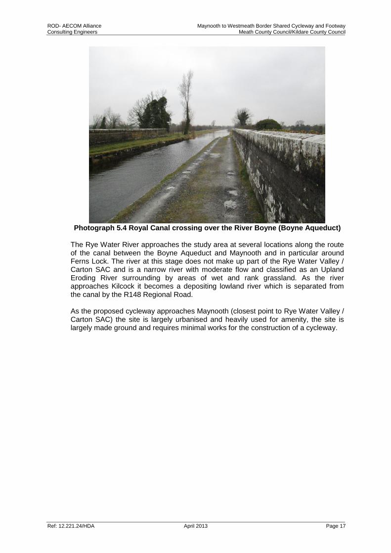
Photograph 5.4 Royal Canal crossing over the River Boyne (Boyne Aqueduct)
The Rye Water River approaches the study area at several locations along the route of the canal between the Boyne Aqueduct and Maynooth and in particular around Ferns Lock. The river at this stage does not make up part of the Rye Water Valley / Carton SAC and is a narrow river with moderate flow and classified as an Upland Eroding River surrounding by areas of wet and rank grassland. As the river approaches Kilcock it becomes a depositing lowland river which is separated from the canal by the R148 Regional Road. As the proposed cycleway approaches Maynooth (closest point to Rye Water Valley / Carton SAC) the site is largely urbanised and heavily used for amenity, the site is largely made ground and requires minimal works for the construction of a cycleway.

ROD- AECOM Alliance Maynooth to Westmeath Border Shared Cycleway and Footway Consulting Engineers Meath County Council/Kildare County Council
Ref: 12.221.24/HDA April 2013 Page 18
Photograph 5.5 Urbanised section of the Royal Canal at Maynooth
6.0 POTENTIAL IMPACTS
6.1 Introduction
This section considers the potential impacts of the proposed Maynooth to Westmeath Border Shared Cycleway & Footway upon the qualifying features of the Natura 2000 sites, as identified in Section 4.0.
6.2 Mount Hevey Bog SAC
The proposed cycle route is within and adjoining Mount Hevey Bog SAC along its northern boundary. Ecological assessment of the site shows that in most areas the canal bank is colonised by aquatic vegetation, with hedgerows, tree lines and scrub forming of the boundary habitat to the south of the towpath. This boundary largely adjoins agricultural lands. The Dublin Sligo Railway line runs to the south of the canal though agricultural land and forestry. No protected species and no invasive plant species were recorded within the towpath study area. Other habitats in proximity to the cycle route include Transition Mire and Quaking Bog where the bank of the canal is widened to allow for a turning area. This area adjoins dry meadow and grassy verges which adjoins the made ground that makes up the existing access road/ pathway. Qualifying interests of the SAC are active raised bogs, degraded raised bogs and Rhynchosporion habitats, none of which are present in proximity to the cycleway. Given the scale of the proposed works which are within and in proximity to the SAC including upgrades to the existing access road and some minor widening, and the distance to qualifying interests (located largely to the south of the Dublin to Sligo Railway line), it can be determined that the proposed cycle route will have no impact on Mount Hevey Bog SAC or its qualifying interests.

ROD- AECOM Alliance Maynooth to Westmeath Border Shared Cycleway and Footway Consulting Engineers Meath County Council/Kildare County Council
Ref: 12.221.24/HDA April 2013 Page 19
6.3 River Boyne and River Blackwater SAC
Protected habitats for the site include alluvial wet woodland and alkaline fen. Alluvial wet woodlands occur on the islands close to Drogheda and along the river in small patches. There are no alluvial wet woodlands in proximity to the proposed cycleway at the Boyne Aqueduct. Alkaline fen within the SAC is found largely in the vicinity of Lough Shesk, Freehan Lough and Newtown Lough and is not present in proximity to the proposed cycleway. The site in proximity to the Boyne Aqueduct is made up of habitats consisting of canals, amenity grassland, scrub, hedgerows and treelines, dry meadows and grassy verges, and building and artificial surfaces. Potential for impact on the River Boyne and River Blackwater SAC is limited to the qualifying species salmon, river lamprey and otter which use the river and in the case of otter the potential for resting areas alongside both the river and canal. The Boyne River at the Boyne Aqueduct is a large and deep river with slow flow. While Salmon and lamprey use the Boyne River at this location, it is not suited to spawning of either species, therefore there will be no impact on these species spawning grounds. There is no in-stream works proposed within the River Boyne. There are no otter holts located along the canal in proximity to the Boyne River although they are likely to use the area for foraging. Otters are largely nocturnal and their foraging activity will not be significantly impacted as a result of increased human disturbance due to construction of the cycleway during daytime hours. No works are proposed within the Royal Canal in the vicinity of the Boyne River. Additionally there is no hydrological relationship between the Royal Canal and the Boyne River. Industry best practice pollution prevention measures (refer Section 7.0) will be enforced to prevent the possible occurrence of a pollution event that may affect the Boyne River. These ensure that there is no significant risk to the water quality of River Boyne as a consequence of the construction of the scheme. The potential for operational phase impacts on the SAC arise from disturbance by users of the cycle route and by the presence of a new path adjoining the SAC. Disturbance as a result of the proposal though an increased number of users will not result in a significant impact on the qualifying species and habitats of the SAC. The cycleway is well above the River Boyne and is subject to disturbance from existing amenity users and is not likely to result in any increased disturbance to the habitats and species in the SAC below. Given the scale of the proposed works which, in proximity to the SAC, include upgrades to the existing road and some minor widening of the road, along with the distance to the qualifying interests of the SAC, it can be determined that the proposed cycle route will have no potential impact on River Boyne and River Blackwater SAC or its qualifying interests.
6.4 River Boyne and River Blackwater SPA
The River Boyne and River Blackwater SPA is designated for kingfisher. The habitat in the vicinity of the proposed cycleway adjoining the canal has not been identified as kingfisher habitat based on surveys carried out by Bird Watch Ireland in 2010. There are no suitable nesting sites for kingfisher along the canal in the vicinity of the Boyne Aqueduct. However kingfisher may use the canal and the aqueduct for foraging at this location. Kingfisher populations are dependent on the amount and quality of prey species within the freshwater environment. Construction methodology will ensure

ROD- AECOM Alliance Maynooth to Westmeath Border Shared Cycleway and Footway Consulting Engineers Meath County Council/Kildare County Council
Ref: 12.221.24/HDA April 2013 Page 20
there is no impact on water quality as a result of the works, mitigation measures are identified in Section 7.0 of this report. Given the scale of the proposed works which in proximity to the SPA includes upgrades to the existing road and some minor widening, and the distance of qualifying interests, it can be determined that the proposed cycle route will have no potential impact on the River Boyne and River Blackwater SPA and its qualifying interest Kingfisher.
6.5 Rye Water Valley / Carton SAC
The scheme runs alongside the Rye Water River before it becomes an SAC in a number of locations including Ferns Lock and east of Kilcock. At Ferns Lock here is a sufficient buffer made up of dry meadow and grassy verges and scrub between the river and the canal tow path where the proposed cycleway is located to prevent impact on the riverine environment. East of Kilcock the river and the canal are separated by a regional road therefore reducing the potential for impact on the river. The Royal can crosses over the Rye Water River to the west of Maynooth where minimal works are required for the provision of the cycleway. The scheme is approximately 1.5km away from Rye Water Valley / Carton SAC. The Royal Canal is closest to the SAC at Louisa Bridge approximately 5.8km east of the proposed works. The site is designated for two species of whorl snail found in marsh areas and petrifying springs, all of which are located in proximity to Louisa Bridge. The canal at Maynooth is largely paved requiring minor maintenance and repair works, given the distance of the works from the SAC it can be concluded that there is no potential impact on the Rye Water and Carton SAC or its qualifying interest.
6.6 Consideration of Potential Cumulative Impacts
The Habitats Directive requires that the potential cumulative impacts on Natura 2000 sites be assessed in combination with other significant projects in the vicinity. The scheme makes up part of the larger proposal for EuroVelo 2: Dublin to Galway. This Cycle Network is subject to appropriate assessment under the habitats directive and consideration is given here to the larger scheme. In the case of Mount Hevey Bog, consideration of impact is given to the larger scheme which continues along the northern boundary of the SAC though Westmeath, regard is had to the scale of the work and the assessment carried out by Westmeath County Council in screening for Appropriate Assessment. The Westmeath assessment determined that there will be no impact on the SAC as a result of the proposed works. In combination with the works proposed for this project there is no change to the impact on the SAC. Therefore it can be determined that both alone and in combination with similar and related projects there will be no negative impact on the qualifying interest of Mount Hevey Bog SAC and its qualifying interests. The Rye Water / Carton SAC is in proximity to the proposed project and potentially in proximity to the Maynooth to Dublin cycle upgrade of the Royal Canal. Therefore, consideration is also given to any construction works that may be required at the Royal Canal Ryewater Aqueduct and the Louisa Bridge for cycle and pedestrian facilities. The canal along the aqueduct and Louisa Bridge is currently in use as a walking / cycling route and requires only minor improvement works for upgrade. However, screening for Appropriate Assessment will be required as part of any planning application for a cycleway. It is noted that any works proposed as part of the Maynooth to Westmeath Border Shared Cycleway & Footway will not result in the

ROD- AECOM Alliance Maynooth to Westmeath Border Shared Cycleway and Footway Consulting Engineers Meath County Council/Kildare County Council
Ref: 12.221.24/HDA April 2013 Page 21
culmination of impacts as a result of additional works required along the canal at Leixlip and in proximity to the SAC. The Royal Canal is managed by Waterways Ireland and is subject to a regular dredging programme. This dredging programme is subject to Appropriate Assessment under the Habitats Directive and all works are carried out under approval from the Department of Arts, Heritage and the Gaeltacht. The dredging programme is carried out in a manner that does not impact on any adjoining Natura 2000 sites. Additionally, as it is considered that the proposed scheme will have no significant impact on any of the Natura 2000 sites listed it can be concluded that there will be no ‘in-combination effects’ as a consequence of the construction or operation of this scheme.
7.0 SPECIFIC MITIGATION / POLLUTION CONTROL MEASURES As stated in Section 5.2 of this report the initial assessment of significance which is undertaken during the screening exercise must be carried out without the consideration of mitigation. However where potential impacts can clearly be avoided through the modification or re-design of the project then these measures can be included within the assessment; an example of this could be timing the construction programme to avoid disturbing overwintering birds, i.e. a design control measure has been applied to avoid any potential impact. As such the following mitigation and control measures are considered as inherent to the design of the scheme and can be included within the Stage 1: Screening assessment. Best Practice Water Quality / Pollution Prevention Measures
All material including oils, solvents and paints will be stored within temporary bunded areas or dedicated bunded containers;
Where possible refuelling will take place in a designated bunded area away from surface water gullies, drains and water bodies, in the event of refuelling outside of this area fuel will be transported in a mobile double skinned tank;
All machinery and plant used will be regularly maintained and serviced and will comply with appropriate standards to ensure that leakage of diesel, oil and lubricants is minimised.
Spill kits and hydrocarbon absorbent packs will be available and drip trays will be used during refuelling;
All relevant personnel will be fully trained in the use of this equipment;
Where soil/made ground and subsoil stripping occurs, the resulting excavated soil fractions will be segregated into inert, non-hazardous and /or hazardous fractions (in accordance with Council Decision 2003/33/EC, the EPA water classification criteria at certain licensed landfills in Ireland);
The excavation and handling of inert material will be carefully managed in such a way as to prevent any potential negative impact on the receiving water environment;
Where possible the excavated spoil would not be stored beyond the working day, however in the event that this is not practical appropriate precautions in

ROD- AECOM Alliance Maynooth to Westmeath Border Shared Cycleway and Footway Consulting Engineers Meath County Council/Kildare County Council
Ref: 12.221.24/HDA April 2013 Page 22
relation to the material will be taken. These precautions will include appropriate storage and covering;
All associated hazardous construction waste will be stored within temporary bunded storage areas prior to removal by an appropriate EPA or Local Authority approved waste management contractor;
Toolbox talks will be provided for all construction staff regarding the importance of best practice and the protection of Natura 2000 sites
Full method statements will be provided by the contractor and approved prior to the commencement of construction.
The guidelines provided by the Department of the Marine and Natural Resources, with respect to concrete wash waters, CIRIA, the UK Environment Agency and Environment and Heritage Service, the UK Department of the Environment and Inland Fisheries Ireland will be adhered to in order to ensure that there is a neutral impact on the water environment during the construction phase of the proposed development.
A project ecologist will be retained for the duration of the construction phase.
A bio-security protocol will be put in place during the construction phase of the development. This will ensure that all plant machinery and equipment will be thoroughly cleaned and inspected for invasive species prior to leaving site
All construction staff will receive training in the identification and management of the invasive species, including identification of knotweed rhizomes and will ensure adherence to the bio-security protocol.
8.0 POTENTIAL RESIDUAL IMPACTS With the successful adherence to the control measures detailed in Section 7.0 no residual impacts are expected. This is demonstrated by re-examining the project against the EC documentation criteria as detailed below.

ROD-AECOM Alliance Maynooth to Westmeath Border Shared Cycleway and Footway Consulting Engineers Meath County Council/Kildare County Council
Ref: 12.221.24/HDA April 2013 Page 23
Does the project have the potential to: Mount Hevey Bog SAC
River Boyne and River
Blackwater SPA
Boyne Estuary SPA
Boyne Coast and Estuary
SAC
Details
cause delays in progress towards achieving the conservation objectives of the site?
No No No No No significant residual negative impacts
interrupt progress towards achieving the conservation objectives of the site?
No No No No No significant residual negative impacts
disrupt those factors that help to maintain the favourable conditions of the site?
No No No No No significant residual negative impacts
interfere with the balance, distribution and density of key species that are the indicators of the favourable condition of the site?
No No No No No significant residual negative impacts
cause changes to the vital defining aspects (e.g. nutrient balance) that determine how the site functions as a habitat or ecosystem?
No No No No No significant residual negative impacts
change the dynamics of the relationships (between, for example, soil and water or plants and animals) that define the structure and/or function of the site?
No No No No No significant residual negative impacts
interfere with predicted or expected natural changes to the site (such as water dynamics or chemical composition)?
No No No No No significant residual negative impacts
reduce the area of key habitats? No No No No No significant residual negative impacts
reduce the population of key species? No No No No No significant residual negative impacts
change the balance between key species? No No No No No significant residual negative impacts
reduce diversity of the site? No No No No No significant residual negative impacts
result in disturbance that could affect population size or density or the balance between key species?
No No No No No significant residual negative impacts
result in fragmentation? No No No No No significant residual negative impacts
result in loss or reduction of key features (e.g. tree cover, tidal exposure, annual flooding, etc.)?
No No No No No significant residual negative impacts

ROD-AECOM Alliance Maynooth to Westmeath Border Shared Cycleway and Footway Consulting Engineers Meath County Council/Kildare County Council
Ref: 12.221.24/HDA April 2013 Page 24
9.0 DISCUSSION AND CONCLUSION The first stage of the Appropriate Assessment process, screening, has been completed in compliance with the relevant European Commission and national guidelines. The potential impacts during the construction and operation of the proposed Maynooth to Westmeath Border Shared Cycleway & Footway has been considered in the context of the Natura 2000 sites, their Qualifying Interests and conservation objectives. The evaluation undertaken has identified that there will be no significant impact on any of the Qualifying Habitats or Species, either alone or in-combination, of Mount Hevey Bog SAC, the River Boyne and River Blackwater SAC and SPA, and the Rye Water / Carton SAC. Therefore, as a result of the assessment carried out, it is considered that the conservation objectives for the Natura 2000 sites will not be compromised by the proposed development, nor will the proposed development have any significant impact on the designated sites or the habitats or species for which they been designated. Conclusion
As a result of the assessment carried out it is the considered view of the author that the proposed development, with the implementation of the measures detailed at Section 7.0, will have no adverse effect on the integrity of any of the Natura 2000 sites listed and as such this report returns a conclusion that there is no potential for significant effects on the Natura 2000 sites. As such the project can be screened out under the Habitats Directive as not requiring a Stage 2 Appropriate Assessment.
10.0 REFERENCES DoEHLG (2010) Appropriate Assessment of Plans and Projects in Ireland - Guidance for Planning Authorities (Department of Environment, Heritage and Local Government, Rev Feb 2010)
European Commission (2001) Assessment of Plans and Projects Significantly Affecting Natura 2000 sites: Methodological Guidance on the Provisions of Article 6(3) and (4) of the Habitats Directive 92/43/EEC (European Commission Environment Directorate-General);
European Commission (2000) Managing Natura 2000 sites: The Provisions of Article 6 of the Habitat’s Directive 92/43/EEC (EC Environment Directorate-General, 2000); hereinafter referred to as “MN2000”
NPWS Circular NPW 1/10 & PSSP 2/10 Appropriate Assessment under Article 6 of the Habitats Directive: Guidance for Planning Authorities. (Department of Environment, Heritage and Local Government, March 2010);
Environmental Agency (2006) Managing Japanese Knotweed on Development Sites: The Knotweed Code of Practice.
Kelly, J., Maguire, C.M. and Cosgrove, P.J. (2008). Best Practice Management Guidelines Japanese knotweed Fallopia japonica. Prepared for NIEA and NPWS as part of Invasive Species Ireland.