

May 2014 Operations Planning Construction Design VISION Process 1.Receive design files from...
24
KY – Single Source of Truth for LRS and Project Selection May 2014
-
Upload
andra-french -
Category
Documents
-
view
215 -
download
2
Transcript of May 2014 Operations Planning Construction Design VISION Process 1.Receive design files from...

KY – Single Source of Truth for LRS and Project
Selection
May 2014

Ope
ratio
ns Planning
Construction Des
ign
VISION
ProcessProcess
Process1. Receive design files from
Projectwise-Create Maps to determine
ownershipand maintenance responsibilities
2. Update the HIS from design files. extract road inventory and centerlines
3. Export HIS to TED weekly for cabinet consumption of GIS and data. Update other Databases with basenetwork and data
4. Consume and overlay other cabinet data (needs)To perform analysis to provide project input to SYP
5. Perform studies and cost estimates, identify and prioritize projects for SYP
6. Design project tosatisfy the draftPurpose and Need

KY uses County – Route – and Mile Point as it’s Linear Referencing System.
All Public Roads mapped and stored within the Highway Information System (HIS).◦ Bentley’s Exor◦ 79,000 total public mileage◦ Roadway Features (Lanes, Median, Shoulder)◦ Roadway Systems (Functional Class, State
System)◦ HPMS Data◦ Traffic Counts◦ Analysis Data
KY LRS Database – Highway Information System (HIS)

State Road Updates◦ Design files downloaded from ProjectWise when the
construction projects are let.◦ HIS updated within 2 weeks of “Open to Traffic”◦ Typical Sections used to populate Roadway
Features Local Road Updates
◦ Contract with 15 Area Development Districts Work with appropriate local officials to identify
changes Submit on set schedule (moving to real time update)
LRS Update

“Question Maps” to Highway District Office

HIS updated digitizing


After initial update of the LRS and Inventory database, the HIS data is then either;◦ Field verified by internal field crew
GPS the total alignment Inventoried for roadway characteristics
◦ Photo Van images reviewed Collection of X and Y of pictures used to verify road
centerline Measure pictures in Mandli software to assure lane #
and widths, shoulder type and width, etc.◦ Future, LIDAR will be available for every project
Verify Accuracy

KYTC Data

Safety Database

Pavement Management SystemPMS
Cracking
Rutting
Pavement Information
IRI

Operations And Maintenance SystemOMS
Mowing
Right Of Way

PONTISBridge Information

Lane Width
Median Type and Width
Roadway Centerline
Shoulder Type and Width
Highway Information System
HIS
And Lane Number

A weekly export of both spatial and tabular data is exported to the Transportation Enterprise Database (TED).
Spatial data is then linked to show up on SDE GIS servers
Tabular data is made available to update other databases and can be consumed through Business Objects
Weekly Data Update of KYTC Enterprise Database (TED)

What is TED?
HIS exports both spatial and tabular To TED on a weekly basis
To Public Weekly

A direct update of both spatial and tabular data is also conducted with the bridge database, Pontis.
Future, a spatial and tabular direct update will take place with the Agile Assets database housing OMS (Maintenance work orders) and PMS (Pavement Management System)
Yearly updates to the Superload database (future will be automated on demand)
Weekly Updates to other Databases

What is TED?
HIS updates bridge route location and Other pertinent HIS data on a weekly basis
HIS exports all spatial changes and Pertinent data to OMS and PMS onA weekly basis
OMS and PMS update weekly to TED
HIS updated from OMSPMS on demand
Data Driven to identify issues by Functional Class (Gap Analysis):◦ Safety Issues◦ Congestion Issues◦ Pavement Issues
Projects overlaid to see if specific issue/s addressed◦ Current 6 year Plan projects◦ Pavement Projects for next 5 years◦ Unscheduled Needs projects◦ HSIP Projects
District staff, MPO, Local Officials, review and prioritize
District Transportation Plan (DTP) TED DATA
Proposed 6 year plan then selected from these lists and submitted to Legislature for approval and funding for the Biennial.
District Transportation Plan (DTP)

DTP Interactive MapSafety and Congestion Issues
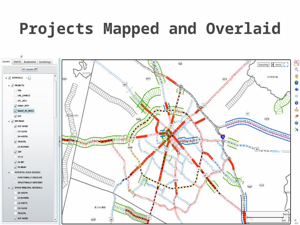
Projects Mapped and Overlaid

Use MAP-21 and Performance Measures to:◦ Develop a Data Driven Draft Six Year Plan
Cost Benefit Analysis. Taylor a plan for each District/Region based on
specific needs of the region. Assure the draft selected projects contribute to
meeting Performance Measure targets.
Future Improvement to DTP


