
Masterthema A Brandlhuber Emerson FS19 - ETH Z
78
abc.xyz Master Thesis Theme A, FS 2019, DARCH, ETH Zurich Studio Brandlhuber + Studio Emerson All Cover Images: Default background for Google’s Pixel 3 phone. source: www.wallpapercave.com
Transcript of Masterthema A Brandlhuber Emerson FS19 - ETH Z

abc.xyz
Master Thesis Theme A, FS 2019, DARCH, ETH ZurichStudio Brandlhuber + Studio Emerson
All C
over
Imag
es: D
efau
lt ba
ckgr
ound
for G
oogl
e’s
Pixe
l 3 p
hone
. sou
rce:
ww
w.wa
llpap
erca
ve.c
om

2 / 78
WHEN THE VIRTUAL BECOMESREAL, WHO WILLDESIGN & BUILDOURCITIES?

3 / 78
INDEX
Introduction
Alphabet, Inc.
New Agents
City as Big Data
Productive Living
POPS
The Task
Methodology
Site
Deliverables
Accompanying Courses
Dates
Sidewalk Labs Toronto Brief
Site
Layers
Typology
PPPs
Texts
Interview with Christian von Borries
Orit Halpern, Beautiful Data
Jurgen Habermas, Public Sphere
Krisitine Miller, Designs on Public
4 — 7
5
5
6
6
7
8 — 14
10
11
12
13
14
15 — 32
16
22
25
30
33 — 78
34-42
43-50
51-57
57-78

4 / 78
In 2017, two of the world’s biggest tech companies – Amazon and Alphabet – spent a total of $39.2 billion on Research and Design (R&D)1, more than any other company worldwide and twenty-times the annual budget of ETH Zürich. But rather than researching new digital services, these companies invested in an even more profitable and safe market: Real Estate.
With their acquired user data, Amazon, Alphabet, and Apple, design new “public” spaces: squares, campuses, parks, and masterplans, pretending to be democtratic2. Through public-private-partnerships, these corporations have adopted the responsibility of the state in the design of public space.
In the context of public-private-partnerships, we are forced to take apart old ideas of public space if today’s new urban masterplans are being bought, designed, and directed by private players.
In a moment where (tech)-companies are building our envirnoment through user-data and algorithms, the question becomes: who architects and why? And how can we, as architects, engage with these new agents in order to keep an active role in designing this new architecture, between infrastructure, systems and buildings?
1https://www.recode.et/2018/4/9/17204004/amazon-research-de-velopment-rd
2“In her recent book Al-gorithms of Oppression, Safiya Umoja Noble challenges the idea that search engines like Google offer an equal playing field for all forms of ideas, identities, and activities. Data discrim-ination is a real social problem.
Noble argues that the combination of private interests in promoting certain sites, along with the monopoly status of a relatively small number of Internet search engines, leads to a biased set of search algorithms that privilege white-ness and discriminate against people of color, specifically women of color- and contributes to our understanding of how racism is creat-ed, maintained, and disseminated in the 21st century.”
Source: https://18.re-pu-blica.com/en/session/algorithms-oppression

5 / 78
ALPHABET INC.3
In 2015, Google restructured itself into a multinational conglomerate called Alphabet. Today, Alphabet is the parent company of many subsidiaries from different industries, ranging from internet services to infrastructure. This move let Google to strengthen its internet services as an independent company, making space for other startups in different industries, like the new urban think tank — Sidewalk Labs.
Merging tech infrastructure with urban planning, Sidewalk Labs was created under Alphabet as an “urban innovation organization,” headed by Dan Doctoroff, the former mayor of economic development in New York city and former CEO of Bloomberg L.P. Their mission is to “improve urban infrastructure through technological solutions,” tackling issues such as “cost of living, efficient transportation, and energy usage.”4
Sidewalk Labs Toronto
In October 2017, Sidewalk Labs announced their future plans to develop Quayside, a 4.9 hectare site in Toronto’s East Bayfront neighborhood. Sidewalk Labs was given the project after a competition organized by the municipal organization, Waterfront Toronto. The proposal imagined a neighborhood “from the internet up,” – a smart city, comprised of 5 layers: the digital layer, buildings, mobility, the public realm, and infrastructure.5
NEW AGENTS
With the global value of all real estate measuring $217 trillion (3 times the global GDP)6, private corporations have started to invest in real estate as a means of economic profit, regardless of their profession. This has led companies like Google, Amazon, and Microsoft, all of whom specialized in immaterial, online services, to take on urban projects as a way of investing in real estate.
Under the pressure of capitalism, we have come to acknowledge these new agents and forces in the making of our built environment. Today, the biggest factor in changing urban landscapes is not an increase in public funding, but is instead the introduction of Amazon headquarters, Facebook campuses, or Google neighborhoods. In this sense, private players have taken over public space, such as infrastructure, as a means of economic investment, shifting the responsibility away from the state.
These new private agents have come into power by involving themselves in our everyday lives, giving into the desires of us — the consumers that were formerly called citizens.
The Architect’s Agency under Sidewalk Labs
As part of their press release for Sidewalk Toronto, Sidewalk Labs released the projected planning phases along with the associated agents for each phase. In March 2017, the planning process begins with Waterfront Toronto (public) and the Innovation and Funding Partner (private). Then, in July 2017, a third partner is added for Infrastructure. Lastly, in a box titled “future process,” the Real Estate Development Team is introduced, encompassing “developers, architects, planners, contracters, etc.”7
3Alphabet website: https://abc.xyz
4“Googe Sidewalk Labs Seeks to Improve City Life,” ArchDaily, https://www.archdaily.com/771696/google-alphabet-sidewalk-labs-seek-to-improve-city-life.
5Sidewalk Labs original RFP Proposal, https://sidewalktoronto.ca/documents/.
6Savills Real Estate Report, https://www.savills.com/impacts/economic-trends/8-things-you-need-to-know-about-the-value-of-global-real-estate.html.
7Sidewalk Labs original RFP Proposal, https://sidewalktoronto.ca/documents/.
6 / 78
With this new model of development, Sidewalk Labs shifts the role of the architect to the last phase of design, first optimizing a functional and economic urban framework, and then bringing the architect in afterwards to realize the predetermined plans. Here, the funding partner becomes the primary designer, determining all major components from the infrastructure, programmatic makeup, technology, and finally to the choice of architect.
CITY AS BIG DATAThe Economy of Future Urbanism8
The city of Songdo, one hour’s drive southwest from Seoul, is the most complete example of a smart-city built from scratch. Occupying one third of the Incheon Free Economic Zone, Songdo was planned and financed by the major network infrastructure provider, Cisco Systems, together with Gale Real Estate – two private American-based companies.9
Planned as a hyper responsive environment of invisible computing, Songdo is saturated with sensors, interfaces, and fiber-optic cables. The city is a programmed organism, constantly receiving and outputting real-time data on humans, transportation, and buildings. While marketed to future residents as an optimized place for living, the city’s true function is instead a ubiquitous laboratory and mine for valuable data.
Like Songdo, Sidewalk Toronto is planned as a completely wired city, delivering live feedback data on everything from trash collection, to air pollution. Initially Sidewalk Labs hired Ann Cavoukian, the former privacy commissioner of Ontario, as their advisor on data privacy. In 2018, Cavoukian resigned from Sidewalk Labs when the company eliminated deidentification protocols, which removes a name associated with its data immediately on collection.10
PRODUCTIVE LIVING 24/7
With the changing market, freelance lifestyles have become the new normal. People work from laptops, in home offices, in their beds. Although usually applauded as newfound freedom, this lifestyle continues production cycles well after work-hours, essentially creating a never-ending work day.
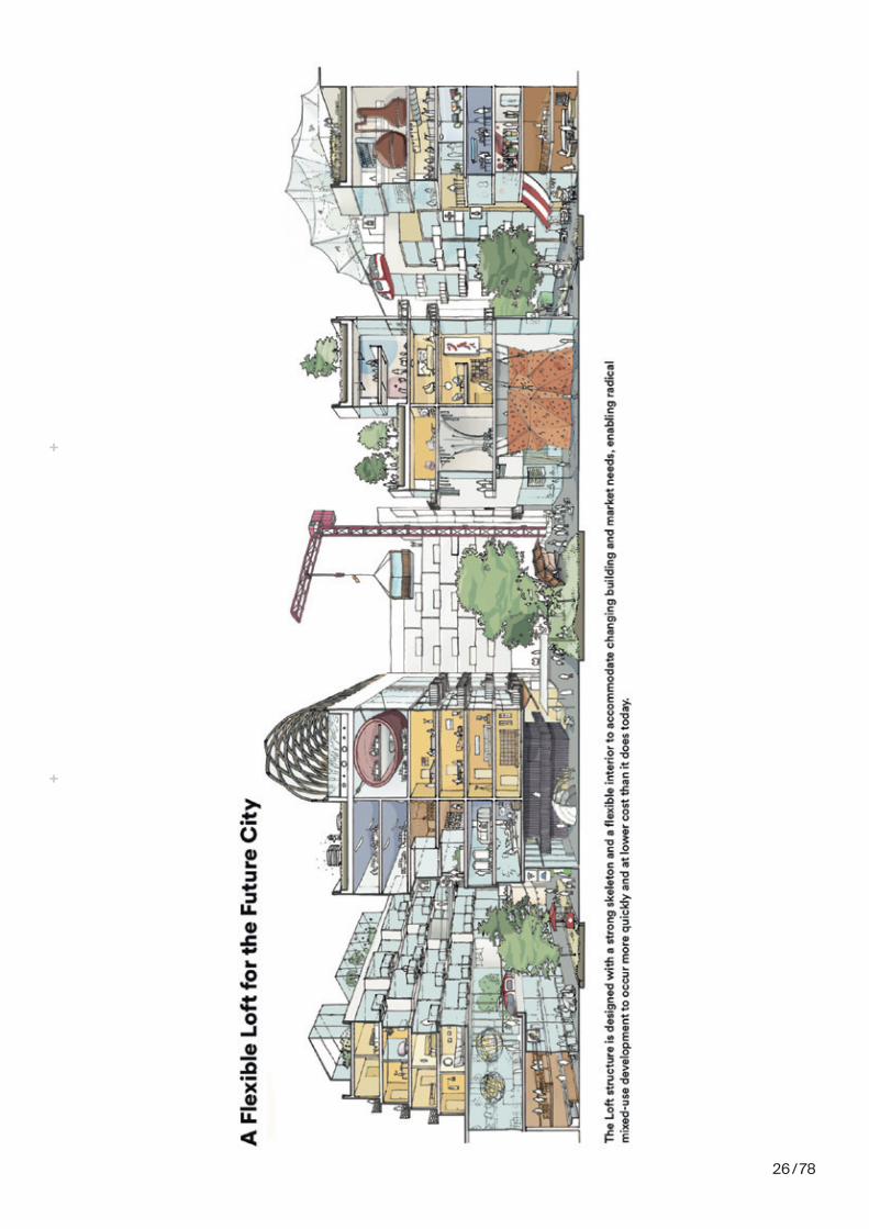
What started as the romantic ideal of the repurposed industrial artist loft, is today being rebranded by Sidewalk Labs as a typology “for ongoing and frequent interior changes around a strong skeletal structure…accommodating a radical mix of uses (such as residential, retail, making, office, hospitality, and parking) that can respond quickly to market demand.” This method is meant to shift user needs “on a months or years long term,” which also maximizes the rent and occupation of the buildings for developers.
Capitalizing on the role of artist-as-maker, the Loft typology is for “new start-ups, makers, satellite restaurateurs, and more traditional businesses looking for temporary meeting space.” The flexible work space lets these users “experiment with new product lines without the overhang of a massive capital expense, creating a much more dynamic retail environment.”11 Rather than separating work and life, living becomes full-time work, optimized by the “flexible” Lofts of Sidewalk Labs.
8see also Christian von Borries: A conversation with Arno Brandlhuber and Olaf Grawert, page 34
9Orit Halpern, Prologue, Beautiful Data (Durham: Duke University Press), 2015.
10“Privacy expert resigns from Sidewalk Labs avidosry role,” Youtube, https://www.youtube.com/watch?v=dh_ObYYsFCg&t=135s&pb-jreload=10.
11Sidewalk Labs original RFP Proposal, https://sidewalktoronto.ca/documents/.

7 / 78
POPSPrivately Owned Public Space
How many things are still public today? In contrast to the 1960s, where governments were still funding building projects, today public enterprises are unable to compete with the real estate giants and foreign tech companies who dominate global cities. Public organizations are therefore forced to partner with private benefactors to afford real estate costs, which often comes with sacrificing elements of public interest.
Public-Private-Partnerships (PPPs) have been invaluable in places like New York and Chicago where, following the 1970s tax cuts, the government was unable to maintain construction of public space. In place of government funding, corporations like Ford and IBM partnered with these cities to build parks, plazas, libraries, and museum. Privately Owned Public Spaces (POPs) came to define some of the most visible gathering spaces in the American city.
Today, POPs make up the majority of public spaces, funded largely by tech giants such as Apple, Microsoft, and Google. In 2016, the Senior Vice President of Apple’s Retail department, Angela Ahrendts, announced a new concept for the company’s already successful retail stores. Instead of being only spaces for shopping, Apple Stores would become community gathering spaces or “town squares.”12
Although the plazas outside Apple stores look public (there’s no door to pass through, no private key card to enter), Apple retains the rights to govern the space, which means private security, opaque modes of surveillance, and plaza designs made explicitly for consumption.
12“Stores are Not Town Squares,” Fast Compa-ny, https://www.fastcom-pany.com/90139799/stores-are-not-town-squares.

The Task
9 / 78
Students will treat the Sidewalk Labs Toronto
brief13 as their planning basis, to design a
typology. This typology shall react on two
specifics of the Sidewalk Labs brief:
1. it shall address the relation to the five urban
layers at the core of the proposal (p. 24), and
2. it shall carry the idea of sustainablity in scale,
material and programm as desribed in “the loft”
section in the brief (p. 25).
For Sidewalk Labs, the single part of a building14
is a small representation and part of both the
buildings15 and the urban fabric16. Thus, the final
design and proposal can be at the scale of a
detail or building, and should imply a broader
logic about a new global architecture. Between
infrastructure, systems and buildings.
Following the logic of contemporary urban
development, the site is located within the
Toronto waterfront and spans three different
types of ownership: 1. City of Toronto (Public),
2. Google Sidewalk Labs (PPP), and 3. Individual
Landowners (Private).
By that, Theme A refocuses the thesis on new
conditions outside academia that will become
the new normal for the architectural profession,
demanding us to take a position between
homogeneity and private ownership.
13https://sidewalktoronto.ca/documents/.
14(scale 1:50—1:2)
15(scale 1:500—1:100)
16(scale 1:5000—1:1000)
10 / 78
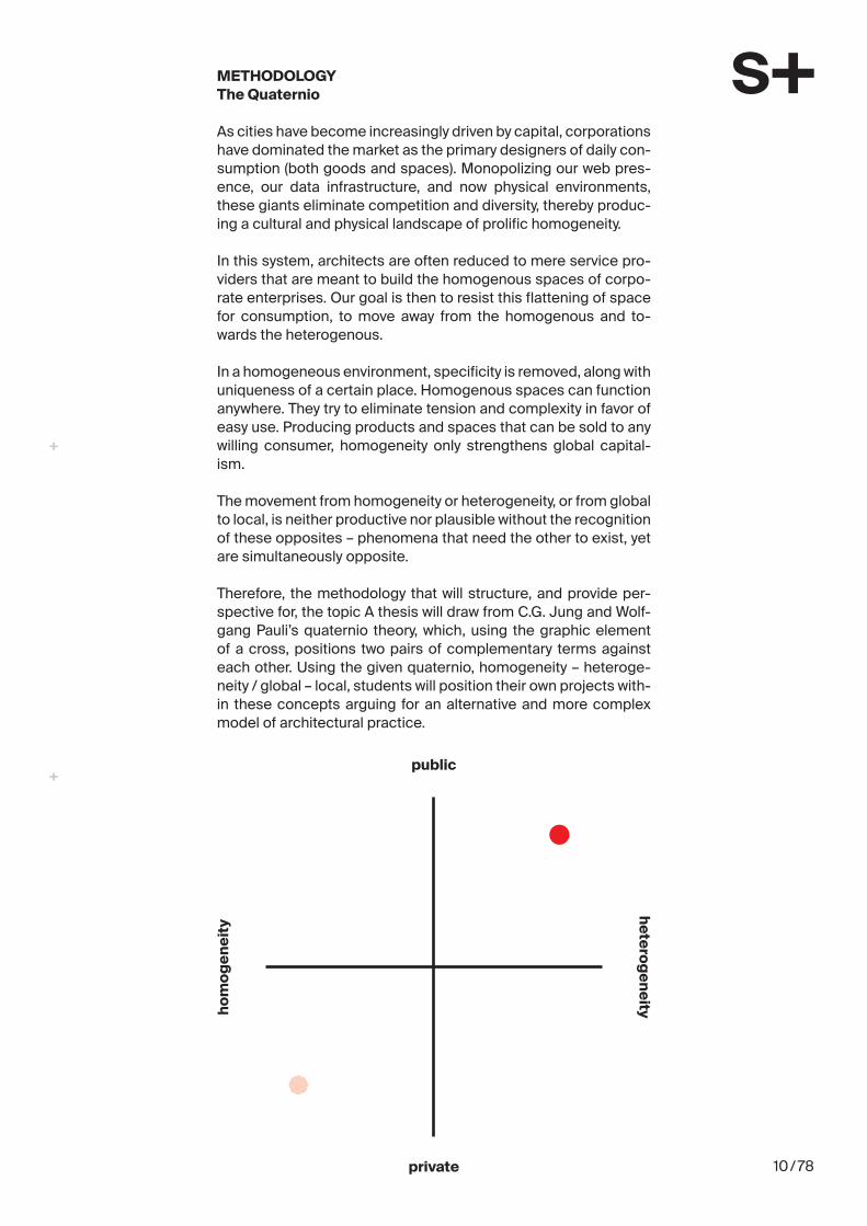
METHODOLOGYThe Quaternio
As cities have become increasingly driven by capital, corporations have dominated the market as the primary designers of daily con-sumption (both goods and spaces). Monopolizing our web pres-ence, our data infrastructure, and now physical environments, these giants eliminate competition and diversity, thereby produc-ing a cultural and physical landscape of prolific homogeneity.
In this system, architects are often reduced to mere service pro-viders that are meant to build the homogenous spaces of corpo-rate enterprises. Our goal is then to resist this flattening of space for consumption, to move away from the homogenous and to-wards the heterogenous.
In a homogeneous environment, specificity is removed, along with uniqueness of a certain place. Homogenous spaces can function anywhere. They try to eliminate tension and complexity in favor of easy use. Producing products and spaces that can be sold to any willing consumer, homogeneity only strengthens global capital-ism.
The movement from homogeneity or heterogeneity, or from global to local, is neither productive nor plausible without the recognition of these opposites – phenomena that need the other to exist, yet are simultaneously opposite.
Therefore, the methodology that will structure, and provide per-spective for, the topic A thesis will draw from C.G. Jung and Wolf-gang Pauli’s quaternio theory, which, using the graphic element of a cross, positions two pairs of complementary terms against each other. Using the given quaternio, homogeneity – heteroge-neity / global – local, students will position their own projects with-in these concepts arguing for an alternative and more complex model of architectural practice.
hom
ogen
eity
heterogeneity
public
private

11 / 78
THE SITEIn the Age of Global Development
In contrast to classical Master Theses, an on-site-visit will not be possible. Still, it is important to understand this case as one ex-ample of contemporary global development and can therefore be understood and researched through different means, from online research to visiting similar sites of urban development.
SIDEWALK LABS TORONTO WATERFRONTParliament Slip
The Sidewalk Labs development spans a total area of 4.9 hect-ares in Quayside, Toronto. The Theme A site is located on the Par-liament Slip within this larger development. It´s confined by three different ownership conditions: public, private and public-private. It further includes the southern half of the existing Victory Soya Mills Silo, that shall be developed by Sidewalk Labs but still be-longs to the City of Toronto.
1Google images showing the site in relationship to Downtown Toronto and the Victory Mills Silo.
2Aerial view of the Thesis Site with overlayed ownership diagram
3Aerial view of surround-ing Toronto region, showing the location of the thesis site within the larger deveopment of Sidewalk Labs, and its connection to down-town Toronto.
Source: http://www.maps.google.com and https://sidewalktoronto.ca/documents/.
1
2
3

12 / 78
REPRESENTATIONFrom Basics, Onward
In addition to the basics of architectural representation (plans, sections, elevations, models) , students are encouraged to select their prefered medium and format, ranging from photographs, videos, performances, publications, or protests.
DELIVERABLES
Each project should be both readable and understandable in dif-ferent scales and speeds, from a one-liner (3 sec.), to an argument (30 sec.), to full length presentation (30 min.).
Urban Site Plan, 1:1000 Plan illustrating the site’s relationship to the larger urban fabric
Local Site Plan, 1:500Plan illustrating the position of intervention(s) on site
Design, 1:200 – 1:100Full description of the typology, in response to the brief
Intervention, 1:50 – 1:2Selected key room(s), intervention(s), or detail(s)
Models, 1:1000 – 1:1Students are encouraged to make physical models appropriate to their proposal, ranging from urban scale to detail mockups
Diagrammatic IsometricDiagram illustrating the connection between the five layers and systems outlined in the brief
QuaternioStudents should locate their proposal on the given quaternio(homogeneity/heterogeneity — private/public)
Design an Argument, 30 sec.Students must develop a clear argument around the topics of public space, privacy, owernship, and technology. The medium should be chosen by the student, and can range from a written statement to audio or video files.
Compress the Argument, 3 sec.Students should develop a means of representation that simply communicates the primary idea behind the project.
13 / 78
ACCOMPANYING COURSES
As the Sidewalk Labs proposal does not differentiate between urbanism, architecture, and the technical detail, the accompany-ing courses reflect this process of design that transcends scale and methodology.
CONSTRUCTIONDaniel Mettler and Daniel Studer
Daniel Mettler: [email protected] Studer: [email protected]
LANDSCAPE ARCHITECTUREProf. Christophe Girot and Prof. Günter Vogt
Andreas Klein: [email protected] Gital: [email protected]
COMPUTER AIDED ARCHITECTURAL DESIGN (CAAD)Prof. Ludger Hovestadt
Marlo Guala: [email protected]
ARCHITECTURE AND TERRITORIAL PLANNINGProf. Milica Topalovic
Hans Hortig: [email protected]

14 / 78
DATESSemester Overview
PresentationMO, 18.2.2019, 9:00 HIL E4, ETH Hönggerberg
Topic IntroductionWE, 20.2.2019, 10:00HIL H40.9 / FoyerWith inputs from Prof. Deane Simpson (Institute for Architecture Urbanism and Landscape, KADK, DK) and Prof. Arno Brandlhuber
Theme SelectionFRI, 22.2.2019, 11:00Communication of the theme selection (A,B,C) to the administra-tion diploma professorship, and chairs of the faculty
Interim ReviewsThe interim reciews take place according to the respective mas-ter professorship
SubmissionTH, 9.5.2019, 18:30HIL Building, ETH Hönggerberg
Exhibition10.5.2019 - 31.5.2019HIL Building, ETH HönggerbergLevels D and E
Celebration31.5.2019, 18:00HIL Building, ETH HönggerbergLevels D and E

The Brief
sour
ce fo
r all d
ocum
ents
: http
s://s
idew
alkt
oron
to.c
a/do
cum
ents
/

6 RFP #2017-13: Innovation and Funding Partner for the Quayside Development Opportunity
I. Overview of the OpportunityWaterfront Toronto is seeking a unique partner, one with invention ingrained in its culture, which can transform conventional business practices and help to establish a benchmark climate positive approach that will lead the world in city building practices. Toronto stands at a crossroads. As a modern, connected and diverse global city, it is an increasingly attractive destination for investors, global talent and tourists. Its real estate market is among the most attractive and durable in North America.Itseconomyisrobust,withfinancialservices, information and communications technology,andfilm,televisionanddigitalproduction fueling continued growth. Newcomers are increasingly choosing to live and work in the booming downtown core, and, as the downtown experiences continued growth, its post-industrial waterfront is transforming into a compelling destination with vibrant public and cultural spaces, best-in-class technology infrastructure, and a range of high-quality housing options and commercial opportunities.
Even with its dynamism, Toronto faces chalenges that are familiar to other cities, such as:
• How do we build a more sustainable city in the face of climate change?
• How do we create places to live for people of all ages, abilities and incomes?
• How do we create jobs and prosperity, and support innovative new businesses?
Toronto’s eastern waterfront, with more than 300 hectares (750 acres) of land subject to future revitalization (see Figure 1), presents a unique opportunity for governments, private enterprise, technology providers, investors and academic institutions to collaborate on these critical challenges and create a new global benchmark for sustainable, inclusive and accessible urban development. Our long-term aspiration for this vast area is to create vibrant, connected, climate-
positive, resilient and prosperous communities.
The Toronto Waterfront Revitalization Corporation ("Waterfront Toronto") is seeking an Innovation and Funding Partner (“the Partner”) that shares our aspirations and will help create and fund a globally-significantcommunitythatwillshowcaseadvanced technologies, building materials, sustainable practices and innovative business models that demonstrate pragmatic solutions toward climate positive urban development. The opportunity in this Request for Proposal (“RFP”) is the Quayside Development (the Project), an approximate 4.9-hectare (12-acre) development site situated along Toronto’s eastern waterfront (see Figure 1) and within walking distance of the vibrant central business district. Comprising sites owned primarily by Waterfront Toronto and the City of Toronto, as well as a privately-held pacel, the Projectoffersapproximately3.3millionsquarefeetof development potential.
The Project is the pilot for which Waterfront Toronto and the Partner will establish a clear vision and action plan for creating a vibrant, climate-positive and prosperous community – one that will serve as a national and global model to encourage market transformation towards climate-positive city building. Waterfront Toronto considers that by achieving key objectives for the Project it may be beneficialtoadvancethesolutions,processesandpartnerships proven successful through the Project to subsequent developments on the eastern waterfront, as those lands become available to Waterfront Toronto (as per the established protocols with the City of Toronto). As the directing agency of the waterfront lands, Waterfront Toronto, therefore, reserves the right to do so. The extent to and the manner in which such successful solutions, processes and partnerships are carried forward into subsequent developments of the eastern waterfrontcouldbeaffectedbyfutureapplicableprocurement policies and additional requirements of the City of Toronto or other funding authorities.
Please see Appendix A for additional background informationonthefloodprotectionworkneededinorder to unlock the development potential of the eastern waterfront and on the plans for other areas within the waterfront.
The Partner will work directly with Waterfront Toronto in the conceptualization, business planning and implementation stages of the Project (see
16 / 78

7Introduction to the Quayside Development
Section VII Partner Scope and Deliverables). Thisincludesidentifyinganddefiningthenecessary technologies, infrastructure, strategies, measurable outcomes and downstream partners that will ensure the Project’s success.
When complete, the Project is envisioned as a highly sustainable mixed-use, mixed-income neighbourhood, providing a range of housing types and amenities as well as addressing the need for mobilityandaccessibility.Itwillofferinclusive,high-quality living for people of all income levels andallstagesoflife.TheProjectwillalsoaffordasignificantopportunitytogenerateprosperityby continuing to build the emerging economic clusters on the waterfront, including employers and job creators in the urban innovation and broader technology sectors. As part of a vibrant waterfront, the Project also has potential to accommodate diverse retail, commercial and institutional development, which may include academic and cultural centres.
Waterfront Toronto has an established track record for raising the bar on sustainability, inclusivity, urban design and innovation, and for developing precedent-setting, dynamic, mixed-use neighbourhoods with strong connections to adjacent communities. Our accomplishments include:
• 2.5 million square feet of development (completed or planned)
• Over 1,400 market residential units built, an additional 1,200 under construction
• 500affordablehousingunitsbuilt,anadditional 80 under construction
• 500-bed George Brown College student residence
• First large scale integrated market residential /affordablerentalbuildinginToronto
• Privately-funded,fibreopticgigabitnetwork across the waterfront
• 36.4 hectares (90 acres) of parks and public spaces
• First new streetcar line in Toronto in 16 years
• 28 km of critical municipal infrastructure
• Economic Impact - approximately $3.9 billion in economic output to the Canadian economy
• $10 billion+ of total market development value on and around the waterfront
• The waterfront is now part of Toronto’s brand – a premier destination attracting visitors, investment and talent
Figure 1. Quayside and the Eastern Waterfront
17 / 78

12 RFP #2017-13: Innovation and Funding Partner for the Quayside Development Opportunity
Figure 4. Development Blocks
VI. The Subject Lands and Their Context
As depicted in Figure 4, the Project area is comprised of three primary sites located along Queens Quay East: the Quayside Development Lands, the Parliament Development Lands and 333 Lakeshore Boulevard East. Basic information regarding each site is provided below. More specificdetailsforeachsite,includingzoningpermissions, are available in the Electronic Data Room.
The provision of light rail transit (“LRT”) in a dedicated right-of-way, as part of a revitalized Queens Quay, has been approved through a Class Environmental Assessment (available in the Electronic Data Room) and will ultimately connect the eastern waterfront to the downtown core. Waterfront Toronto is actively pursuing funding options to extend the LRT along Queens Quay East, including private sector contributions and a phased implementation plan that could include interim bus rapid transit (BRT).
Quayside Development Block (Quayside)(1.8 hectares/4.5 acres)
The Quayside Development Block includes all the land between Bonnycastle Street and Small Street, and Lake Shore Boulevard East and Queens Quay East. These lands are owned by Waterfront Toronto and currently house three low-rise industrial buildings as well as ancillary parking. It is intended that the future developers will be responsible for removing existing structures, as part of the redevelopment plans.
Theby-lawineffectforTheQuaysideDevelopmentBlock restricts the built form and is not prescriptive withregardtoallowablegrossfloorarea.However,a built form analysis results in an estimated mixed-usegrossfloorareaofapproximately1.75millionsquare feet.
18 / 78
TO LI
VE I
N TO
RON
TO TO
DAY I
S TO
EXPE
CT C
HA
NG
E. T
he c
ity is
in th
e m
idst
of
a tr
ansf
orm
atio
n th
at is
not
onl
y in
tens
ifyin
g its
urb
an c
entr
e bu
t lin
king
it to
an
entir
e re
gion
spa
nnin
g th
e sh
ores
of L
ake
Ont
ario
. As
its n
eigh
bour
hood
s be
com
e de
nser
and
tow
ers
grow
talle
r, To
ront
o is
st
rain
ing
agai
nst i
ts a
ging
infr
astr
uctu
re a
nd th
e tr
aditi
onal
ly s
lugg
ish
pace
of
urb
an c
hang
e.
But t
he c
ondi
tions
are
righ
t for
Tor
onto
to o
verc
ome
thes
e ch
alle
nges
and
ga
in w
ide
reco
gniti
on a
s th
e gr
eat g
loba
l hub
that
its
heav
ily im
mig
rant
po
pula
tion
alre
ady
know
s it
to b
e. A
met
amor
phos
is is
und
erw
ay, a
nd it
is
pal
pabl
e th
roug
hout
the
city
. New
peo
ple
with
new
tale
nts
are
brin
ging
ne
w id
eas.
New
ene
rgy
is b
eing
cha
nnel
ed in
to c
hang
e.
Any
loca
l will
tell
you
that
the
next
dec
ade
is p
ivot
al. T
he b
est e
ndin
g to
th
is s
tory
is n
ot T
oron
to b
ecom
ing
the
next
New
Yor
k or
San
Fra
ncis
co. I
t is
Tor
onto
bec
omin
g a
bett
er v
ersi
on o
f wha
t it h
as a
lway
s st
rived
to b
e: a
ci
ty th
at w
orks
—fo
r eve
ryon
e.
The
pres
sure
s pu
shin
g ag
ains
t thi
s id
eal o
f inc
lusi
ve g
row
th a
re m
ount
ing,
bu
t so,
too,
is a
n ap
prec
iatio
n fo
r wha
t mak
es th
e ci
ty s
peci
al. P
eopl
e ar
e re
disc
over
ing
its w
ater
fron
t and
ravi
nes—
the
twin
topo
grap
hies
that
sh
ape
the
city
. The
y ar
e pu
shin
g fo
r a p
edes
tria
n re
alm
that
enc
oura
ges
so
cial
coh
esio
n an
d a
tran
sit s
yste
m th
at d
oes
not r
equi
re li
fe w
ith a
car
.
They
are
cel
ebra
ting
the
city
’s ex
celle
nt p
ublic
sch
ools
and
libr
arie
s an
d in
stitu
tes
of h
ighe
r edu
catio
n as
a k
ey d
river
of u
pwar
d m
obili
ty. A
nd
they
are
cla
mor
ing
for a
city
sty
le th
at is
den
se a
nd e
nerg
ized
, mix
ed a
nd
mes
sy, c
ivil
yet i
nspi
ring.
Toro
nto
is a
city
of n
eigh
bour
hood
s, a
nd if
it h
opes
to m
eet i
ts g
row
th
chal
leng
es—
with
sev
eral
mill
ion
peop
le e
xpec
ted
to jo
in th
e m
etro
are
a in
the
next
25
year
s—it
will
nee
d ne
w o
nes
that
mee
t the
se a
spira
tions
. Th
at m
eans
turn
ing
to th
e Ea
ster
n W
ater
fron
t as
the
city
’s ne
xt g
reat
ne
ighb
ourh
ood
fron
tier.
New
com
mun
ities
will
nee
d to
em
erge
alo
ng th
e w
ater
. The
se c
omm
uniti
es
will
nee
d to
be
forw
ard-
look
ing,
inco
rpor
atin
g th
e be
st tr
aditi
onal
urb
an
form
s w
ith th
e la
test
pla
nnin
g de
sign
s an
d di
gita
l tec
hnol
ogy.
For
tuna
tely
th
ese
com
mun
ities
will
not
hav
e to
look
far f
or in
spira
tion.
The
y ca
n bo
rrow
fr
om th
e st
reet
-leve
l var
iety
of L
eslie
ville
and
Riv
erda
le, t
he s
usta
inab
ility
and
vi
bran
cy o
f the
Can
ary
Dis
tric
t, th
e m
ixed
-hou
sing
and
pub
lic s
pace
of S
t. La
wre
nce
Mar
ket.
The
wat
erfr
ont h
as a
ll th
e as
sets
to a
chie
ve it
s go
als.
Wha
t it n
eeds
now
is a
jum
p st
art.
10INT
ROD
UC
TIO
N
RFP
NO
. 201
7-13
APP
END
IX
Toro
nto:
A D
ynam
ic C
ity S
tepp
ing
Ahe
ad
19 / 78

13RF
PN
O. 2
017-
13A
PPEN
DIX
INTR
OD
UC
TIO
N
20 / 78

Redi
scov
erin
g th
e W
ater
fron
t
36REIM
AG
ININ
G T
HE
EAST
ERN
WA
TER
FRO
NT
RFP
NO
. 201
7-13
APP
END
IX
NO
W S
OM
ETH
ING
DIF
FERE
NT IS
HA
PPEN
ING
.
Wat
erfr
ont T
oron
to h
as s
pear
head
ed th
is re
vita
lizat
ion.
In 19
99,
wat
erfr
ont r
eviv
al w
as d
eem
ed a
mat
ter o
f nat
iona
l im
port
ance
, and
all
thre
e le
vels
of g
over
nmen
t cam
e to
geth
er to
cre
ate
Wat
erfr
ont T
oron
to
to le
ad th
is im
port
ant m
issi
on. S
ince
then
, the
Cen
tral
Wat
erfr
ont h
as
take
n sh
ape
and
Dow
ntow
n To
ront
o ha
s re
cove
red
its la
kefr
ont a
s a
publ
ic a
men
ity—
the
city
’s w
elco
min
g “f
ront
por
ch.”
Now
that
pro
gres
s is
ex
tend
ing
east
war
d.
The
East
ern
Wat
erfr
ont i
s at
ano
ther
sca
le fr
om C
entr
al W
ater
fron
t de
velo
pmen
t; it
is a
dis
tric
t of s
ome
300
hect
ares
com
para
ble
in s
ize
to
Toro
nto’
s en
tire
dow
ntow
n. T
rans
form
ing
the
East
ern
Wat
erfr
ont w
ill
com
plet
e a
long
his
toric
al a
rc, a
s th
e ci
ty’s
lake
shor
e w
as s
hape
d fir
st
by th
e de
sire
for p
ublic
acc
ess,
then
for 1
50 y
ears
by
the
impe
rativ
es o
f in
dust
ry a
nd s
hipp
ing,
and
now
bac
k ag
ain
to p
eopl
e.
Toro
nto’
s la
kefr
ont,
with
all
of it
s co
ntra
dict
ions
and
con
flict
s, is
a
pow
erfu
l opp
ortu
nity
for n
ew a
nd in
nova
tive
thin
king
. Alre
ady
the
Dis
tille
ry D
istr
ict h
as b
ecom
e an
all-
seas
on m
agne
t, dr
awin
g To
ront
onia
ns
to it
s pe
dest
riani
zed,
bric
k-pa
ved
stre
ets.
Nex
t doo
r, th
e C
anar
y D
istr
ict
is a
han
dsom
e sh
owca
se fo
r a n
ew, p
layf
ul, a
nd in
vitin
g ur
bani
sm. T
he
wat
erfr
ont i
s lig
htin
g up
and
the
ener
gy s
urro
undi
ng it
will
soo
n ov
erco
me
the
barr
iers
that
his
toric
ally
con
trib
uted
to it
s ne
glec
t.
In ti
me,
the
East
ern
Wat
erfr
ont w
ill b
e To
ront
o’s
new
est n
eigh
bour
hood
—or
, mor
e lik
ely,
a d
iver
se s
et o
f nei
ghbo
urho
ods
with
thei
r ow
n un
ique
pe
rson
aliti
es—
and
hom
e to
tens
of t
hous
ands
of T
oron
toni
ans.
The
mos
t ex
citin
g th
ing
Toro
nto
can
do is
to b
uild
mor
e of
wha
t mak
es s
o m
any
of it
s ne
ighb
ourh
oods
bel
oved
, and
to g
ive
a m
oder
n, a
mbi
tious
, and
ge
nero
us fo
rm to
the
elem
ents
that
mak
e th
e ci
ty a
suc
cess
.
Loca
ted
adja
cent
to th
e Re
dpat
h Su
gar F
acto
ry, S
ugar
Be
ach
Park
and
its
icon
ic
umbr
ella
s w
elco
me
visi
tors
to
Eas
t Bay
fron
t
Cre
dit:
Mar
k W
icke
ns
Vie
w fr
om S
imco
e W
aved
eck,
as
cycl
ists
pa
ss a
long
the
Mar
tin
Goo
dman
Tra
il
Cre
dit:
Mar
k W
icke
ns
21 / 78
12INT
ROD
UC
TIO
N
RFP
NO
. 201
7-13
APP
END
IXIN
TRO
DU
CTI
ON
SID
EWA
LK LA
BS W
AS F
ORM
ED TO
HEL
P FA
ST-G
ROW
ING
CIT
IES m
eet t
he v
ery
chal
leng
es th
at T
oron
to is
faci
ng to
day.
Its
mis
sion
is to
take
the
grea
t pr
inci
ples
of u
rban
pla
nnin
g—th
e sa
me
ones
Tor
onto
has
out
lined
in
its
grow
th p
lan
for t
he c
ore,
suc
h as
aff
orda
bilit
y, in
clus
ivity
, and
su
stai
nabi
lity—
and
acce
lera
te th
em in
to th
e di
gita
l age
.
Ove
r the
pas
t 200
yea
rs, t
he g
reat
est l
eaps
forw
ard
in u
rban
life
hav
e oc
curr
ed a
t the
inte
rsec
tion
of n
ew te
chno
logy
and
the
phys
ical
en
viro
nmen
t. Th
e st
eam
eng
ine,
ele
ctric
ity, a
nd th
e au
tom
obile
all
tran
sfor
med
how
peo
ple
live
in c
ities
toda
y. T
hese
adv
ance
s w
ere
not
with
out t
heir
draw
back
s, o
f cou
rse,
but
they
fund
amen
tally
cha
nged
the
capa
bilit
ies
of c
ities
.
The
wor
ld is
on
the
cusp
of a
four
th re
volu
tion
in u
rban
tech
nolo
gy e
very
bi
t as
pow
erfu
l as
the
prev
ious
one
s, d
riven
by
ubiq
uito
us c
onne
ctiv
ity,
mac
hine
lear
ning
, and
new
adv
ance
s in
des
ign
and
digi
tal f
abric
atio
n. B
ut
as T
oron
to k
now
s, c
ities
do
not h
ave
time
to w
ait f
or tr
ansp
orta
tion
to
beco
me
clea
ner a
nd m
ore
conv
enie
nt, f
or h
ousi
ng p
rices
to d
eclin
e, fo
r jo
b op
port
uniti
es to
gro
w. T
he p
ace
of u
rban
cha
nge
is to
o sl
ow.
To o
verc
ome
this
cha
lleng
e, S
idew
alk
star
ted
with
a q
uest
ion:
Wha
t cou
ld
toda
y’s
citie
s lo
ok li
ke if
they
wer
e bu
ilt fr
om s
crat
ch in
the
inte
rnet
age
? W
hat e
mer
ged
from
this
thou
ght e
xper
imen
t was
not
a s
erie
s of
ans
wer
s:
ther
e ar
e no
sim
ple
solu
tions
to th
e pr
oble
ms
of u
rban
gro
wth
. Ins
tead
it
is a
new
app
roac
h th
at s
ees
citie
s as
pla
tform
s fo
r urb
an in
nova
tion
that
cr
eate
the
cond
ition
s fo
r peo
ple
to b
uild
, tes
t, an
d re
fine
new
idea
s th
at
can
impr
ove
qual
ity o
f life
.
Build
ing
new
nei
ghbo
urho
ods
from
the
inte
rnet
up
is a
rem
arka
ble
oppo
rtun
ity to
em
bed
emer
ging
dig
ital c
apab
ilitie
s in
to c
ore
infr
astr
uctu
re
from
the
star
t. Ph
ysic
al s
pace
s lik
e bu
ildin
gs, s
tree
ts, a
nd p
arks
can
be
desi
gned
for t
he o
ppor
tuni
ties
that
tech
nolo
gy p
rese
nt, r
athe
r tha
n fo
rced
to
retr
ofit n
ew a
dvan
ces
very
slo
wly
and
at g
reat
cos
t. By
mer
ging
the
phys
ical
an
d th
e di
gita
l int
o a
neig
hbou
rhoo
d’s
foun
datio
n, p
eopl
e ar
e em
pow
ered
w
ith th
e to
ols
to a
dapt
to fu
ture
pro
blem
s no
one
can
ant
icip
ate.
Such
a p
lace
qui
ckly
bec
omes
a li
ving
labo
rato
ry fo
r urb
an in
nova
tion.
G
iven
the
spee
d of
tech
nolo
gica
l cha
nge,
citi
es w
ill o
nly
mee
t the
ir gr
owth
ch
alle
nges
if th
ey s
uppo
rt in
nova
tion
not r
ight
now
but
10, 2
0, a
nd 5
0 ye
ars
ahea
d. T
o do
so
requ
ires
desi
gnin
g fo
r rad
ical
flex
ibili
ty, e
nabl
ing
the
best
id
eas
to b
e re
fined
in re
al ti
me
and
crea
ting
a cy
cle
of o
ngoi
ng im
prov
emen
t dr
iven
by
the
feed
back
of r
esid
ents
and
the
ener
gy o
f ent
repr
eneu
rs, r
athe
r th
an p
resc
ribed
by
plan
ners
and
des
igne
rs.
Of c
ours
e, th
e ob
ject
ive
is n
ot to
sho
wca
se te
chno
logy
for i
ts o
wn
sake
. In
stea
d, it
is to
ena
ble
wha
t is
best
abo
ut c
ities
—di
rect
hum
an in
tera
ctio
n—w
ithou
t im
posi
ng th
e ba
rrie
rs th
at p
reve
nt p
eopl
e fr
om c
onne
ctin
g an
d lim
it th
eir a
cces
s to
the
city
’s m
any
reso
urce
s. T
echn
olog
y ca
n he
lp c
reat
e co
mpl
ete
com
mun
ities
that
are
hig
hly
inte
ract
ive
and
acce
ssib
le to
all,
fr
eein
g re
side
nts
from
the
cons
trai
nts
impo
sed
by th
e he
avy
infr
astr
uctu
re
and
spat
ial h
iera
rchi
es o
f the
last
cen
tury
.
In th
at s
ense
, Sid
ewal
k’s
mis
sion
is n
ot to
cre
ate
a ci
ty o
f the
futu
re a
t all.
It is
to
cre
ate
the
futu
re o
f citi
es.
Side
wal
k La
bs: W
here
the
Phys
ical
Pla
ce
Mee
ts a
New
App
roac
h
The
East
ern
Wat
erfr
ont i
s th
e id
eal l
ocat
ion
to
dem
onst
rate
the
pow
er o
f for
war
d-th
inki
ng u
rban
de
sign
and
tech
nolo
gica
l inn
ovat
ion.
Cre
dit:
Mar
k W
icke
ns
13RF
PN
O. 2
017-
13A
PPEN
DIX
INTR
OD
UC
TIO
N
22 / 78

18A N
EW K
IND
OF
NEI
GH
BOU
RHO
OD
RFP
NO
. 201
7-13
APP
END
IX
Inno
vatio
n at
the
Ph
ysic
al a
nd D
igita
l Lay
ers
AT T
HE
HEA
RT O
F SI
DEW
ALK
’S A
PPRO
AC
H to
bui
ldin
g a
neig
hbou
rhoo
d fr
om
the
inte
rnet
up
is v
iew
ing
it as
a p
latfo
rm th
at in
tegr
ates
the
phys
ical
en
viro
nmen
t with
dig
ital t
echn
olog
y, c
reat
ing
the
core
con
ditio
ns fo
r ur
ban
inno
vatio
n.
Trad
ition
ally,
the
phys
ical
com
pone
nts
of a
city
hav
e be
en fi
xed
into
pla
ce
from
the
star
t, co
nstr
aini
ng n
ew d
evel
opm
ent a
s th
ey b
ecom
e ou
tdat
ed
and
cost
ly to
upg
rade
. A g
row
ing
city
mus
t hav
e bu
ilt-in
flex
ibili
ty to
su
ppor
t ong
oing
inno
vatio
n, a
nd th
e ab
ility
to a
djus
t as
tech
nolo
gy,
mar
ket c
ycle
s, a
nd u
rban
life
styl
es m
ove
in n
ew d
irect
ions
.
Side
wal
k en
visi
ons
a ph
ysic
al la
yer t
hat i
s fa
r mor
e ad
apta
ble
and
open
to
cha
nge
than
wha
t is
foun
d in
citi
es to
day.
The
four
key
com
pone
nts
to th
is la
yer—
flexi
ble
build
ings
, peo
ple-
first
str
eets
, an
adap
tabl
e pu
blic
re
alm
, and
ope
n ut
ility
infr
astr
uctu
re—
are
expl
ored
in g
reat
er d
etai
l in
this
sec
tion.
Thre
aded
thro
ugh
all t
hese
com
pone
nts
is th
e pl
atfo
rm’s
digi
tal
laye
r—a
new
and
tran
sfor
mat
ive
elem
ent.
Dis
trib
uted
thro
ugho
ut th
e ne
ighb
ourh
ood
via
sens
ors
and
othe
r con
nect
ed te
chno
logy
, the
dig
ital
laye
r pro
vide
s an
unp
rece
dent
ed d
egre
e of
insi
ght i
nto
the
phys
ical
en
viro
nmen
t. A
nd w
ith h
eigh
tene
d ab
ility
to m
easu
re th
e ne
ighb
ourh
ood
com
es b
ette
r way
s to
man
age
it.
This
cap
acity
to e
volv
e in
resp
onse
to n
ew th
inki
ng w
ill h
elp
Toro
nto
mee
t th
e un
fore
seen
cha
lleng
es o
f the
futu
re.
23 / 78

19A
NEW
KIN
D O
F N
EIG
HBO
URH
OO
D
INFR
AST
RUC
TURE
PUBL
IC R
EALM
MO
BILI
TY
BUIL
DIN
GS
DIG
ITA
L LA
YER
Dig
ital
Lay
er
Build
ings
Mob
ility
Publ
ic R
ealm
Infr
astr
uctu
re
PHYSICAL LAYER
24 / 78

BUIL
DIN
GS
AN
D A
FFO
RDA
BILI
TY
114
RFP
NO
. 201
7-13
APP
END
IX
Loft
Build
ings
toda
y ar
e us
ually
des
igne
d fo
r a
sing
ular
pur
pose
. How
ever
cha
ngin
g us
er
need
s an
d sh
iftin
g ec
onom
ic c
ondi
tions
of
ten
dem
and
chan
ge. T
his
expo
ses
a pr
oble
mat
ic m
ism
atch
: bui
ldin
gs a
re
desi
gned
to la
st fa
r lon
ger t
han
thei
r use
rs’
need
s re
mai
n co
nsta
nt.
Whi
le m
odul
ar c
onst
ruct
ion
is o
ne m
eans
of
inje
ctin
g fle
xibi
lity
into
urb
an a
reas
, a s
econ
d st
rate
gy is
to d
esig
n bu
ildin
gs w
ith a
n ad
apta
ble
shel
l and
ver
satil
e co
re s
truc
ture
th
at c
an b
e m
ore
easi
ly fl
exed
for d
iffer
ent
uses
. Thi
s id
ea is
the
basi
s fo
r Sid
ewal
k’s
Loft
co
ncep
t.
Loft
impr
oves
upo
n tr
aditi
onal
loft
bui
ldin
gs
by p
lann
ing
expl
icitl
y fo
r ong
oing
and
fr
eque
nt in
terio
r cha
nges
aro
und
a st
rong
sk
elet
al s
truc
ture
. Its
str
uctu
re w
ill re
mai
n fle
xibl
e ov
er th
e co
urse
of i
ts li
fecy
cle,
ac
com
mod
atin
g a
radi
cal m
ix o
f use
s (s
uch
as re
side
ntia
l, re
tail,
mak
ing,
offi
ce,
hosp
italit
y, a
nd p
arki
ng) t
hat c
an re
spon
d qu
ickl
y to
mar
ket d
eman
d.
Whi
le th
e Lo
ft c
once
pt is
prim
arily
ge
ared
tow
ard
reno
vatio
ns a
nd re
trofi
ts
to a
ccom
mod
ate
shift
ing
user
nee
ds o
n a
mon
ths-
or y
ears
-long
tim
e fr
ame,
Sid
ewal
k be
lieve
s a
reta
il-or
ient
ed v
aria
tion
of th
is
notio
n co
uld
allo
w s
pace
s to
cha
nge
alm
ost
daily
. Sid
ewal
k ca
lls th
is d
eriv
ativ
e N
ext-
Gen
Baz
aar.
By o
utfit
ting
spac
e ty
pica
lly
rese
rved
for t
empo
rary
reta
il us
es—
like
farm
ers
mar
kets
and
sho
ppin
g st
alls
—w
ith
the
mor
e su
stai
nabl
e co
re in
fras
truc
ture
de
velo
ped
for L
oft,
the
wat
erfr
ont c
an c
reat
e gr
eate
r div
ersi
ty in
the
type
s of
pop
-up
esta
blis
hmen
ts th
at w
ill a
ppea
r for
a li
mite
d tim
e in
diff
eren
t nei
ghbo
urho
ods.
Thi
s w
ill b
ette
r ser
ve th
e va
ried
need
s of
new
st
art-
ups,
mak
ers,
sat
ellit
e re
stau
rate
urs,
an
d m
ore
trad
ition
al b
usin
esse
s lo
okin
g fo
r te
mpo
rary
mee
ting
or p
ublic
eng
agem
ent
spac
e. M
ore
spec
ifica
lly, i
t wou
ld a
llow
th
em to
exp
erim
ent w
ith n
ew o
ffer
ings
and
pr
oduc
t lin
es w
ithou
t the
ove
rhan
g of
a
mas
sive
cap
ital e
xpen
se, c
reat
ing
a m
uch
mor
e dy
nam
ic re
tail
envi
ronm
ent.
Side
wal
k w
ill p
roto
type
bot
h th
e co
re
Loft
and
Nex
t-G
en B
azaa
r con
cept
s in
Q
uays
ide.
The
Lof
t pilo
t will
like
ly c
onta
in
park
ing
spac
e th
at c
ould
eas
ily tr
ansi
tion
to o
ther
use
s on
ce s
hare
d m
obili
ty re
duce
s pr
ivat
e ca
r use
and
par
king
nee
ds. T
he
Nex
t-G
en B
azaa
r pilo
t will
ble
nd p
ublic
and
pr
ivat
e sp
ace
to a
llow
reta
ilers
and
new
bu
sine
sses
to s
et u
p sh
op in
Tor
onto
’s ne
wes
t ne
ighb
ourh
ood
with
out u
pfro
nt c
apita
l ris
k.
Build
ing
Typo
logi
es
CIT
IES,
THEI
R EC
ON
OM
IES,
AN
D TH
EIR D
EMO
GRA
PHIC
S ch
ange
ov
er ti
me,
oft
en in
unp
redi
ctab
le w
ays.
Bui
ldin
g us
ages
sh
ould
cha
nge
with
them
. The
cas
t-iro
n bu
ildin
gs th
at li
ne
the
stre
ets
of N
ew Y
ork’
s So
Ho
toda
y, fo
r exa
mpl
e, w
ere
once
m
anuf
actu
ring
site
s ho
usin
g m
assi
ve m
achi
nery
. Des
pite
N
ew Y
ork’
s de
clin
e as
an
indu
stria
l hub
, the
se b
uild
ings
hav
e m
aint
aine
d th
eir r
elev
ance
—re
-inve
ntin
g th
emse
lves
as
light
m
anuf
actu
ring
spac
es, s
mal
l offi
ces,
live
-wor
k st
udio
s, a
nd
apar
tmen
ts. T
his
mul
tiuse
life
cyc
le is
mad
e po
ssib
le b
y th
e bu
ildin
gs’ s
tron
g sk
elet
al s
truc
ture
—th
eir “
good
bon
es”—
allo
win
g th
em to
acc
omm
odat
e an
d an
ticip
ate
chan
ging
use
ov
er ti
me.
Qua
ysid
e w
ill b
e no
di ff
eren
t. W
here
as to
day
build
ings
tend
to
be
desi
gned
for s
ingl
e us
e, Q
uays
ide
stru
ctur
es w
ill b
e de
sign
ed u
pfro
nt to
acc
omm
odat
e a
radi
cal m
ix o
f use
s an
d an
ticip
ate
chan
ging
pre
fere
nces
. Opt
imiz
ed fo
r opt
iona
lity,
sp
aces
will
be
equi
pped
with
the
core
infr
astr
uctu
re to
ada
pt
to th
e ev
olvi
ng d
eman
ds o
f Tor
onto
nian
s. A
par
king
str
uctu
re
built
for c
onve
ntio
nal v
ehic
les
toda
y w
ill b
e ab
le to
ada
pt o
ver
time
to b
ecom
e a
mar
ketp
lace
, mak
ersp
ace,
cre
ativ
e o ffi
ce,
or re
side
ntia
l lof
ts, a
s co
nven
tiona
l car
s be
com
e le
ss p
reva
lent
an
d se
lf-dr
ivin
g ca
rs m
ore
popu
lar.
The
over
arch
ing
goal
is to
allo
w n
eigh
bour
hood
s al
ong
the
wat
er to
evo
lve
to m
atch
cha
ngin
g us
er n
eeds
—a
mod
el th
at
can
who
lly re
defin
e ur
ban
expe
rienc
es b
y m
aint
aini
ng d
ynam
ic
neig
hbou
rhoo
ds.
25 / 78
26 / 78

115
PURP
OSE
FUL
SOLU
TIO
NS
Toda
y, a
ll bu
ildin
g sy
stem
s ha
ve fu
ncti
onal
lif
espa
ns fa
r bey
ond
thei
r des
ired
life
span
s,
resu
ltin
g in
was
te a
nd in
flexi
bilit
y.
As
illus
trat
ed b
elow
, bui
ldin
g co
mpo
nent
s m
ade
avai
labl
e by
cur
rent
con
stru
ctio
n m
etho
ds a
re u
sed
for o
nly
a fr
acti
on o
f the
ir
pote
ntia
l mat
eria
l life
span
.
Theo
reti
cal
Theo
reti
cal
Inte
rior
s Li
fesp
anIn
teri
ors
Life
span
Encl
osur
e Li
fesp
anEn
clos
ure
Life
span
Stru
ctur
al L
ifesp
anSt
ruct
ural
Life
span
End
of F
unct
ion
End
of F
unct
ion
Typi
cal
Loft
Built
-in-
plac
e dr
ywal
l dem
olis
hed
for n
ew u
se
Failu
re o
f wea
ther
ba
rrie
r or p
oor
ther
mal
per
form
ance
Build
ing
dem
olis
hed
prio
r to
stru
ctur
e’s
end
of li
fe
30 Y
ears
40 Y
ears
100
Year
s
20 Y
ears
7 Ye
ars
70 Y
ears
Built
onl
y fo
r one
use
Typi
cal B
uild
ings
100
Year
s
Loft
add
ress
es th
is m
ism
atch
in u
se a
nd
lifes
pan
by fo
cusi
ng o
n a
robu
st b
uild
ing
exte
rior
, tak
ing
adva
ntag
e of
the
extr
emel
y lo
ng li
fesp
an o
f maj
or b
uild
ing
com
pone
nts.
Then
, by
mak
ing
the
inte
rior
s hi
ghly
fle
xibl
e w
ith s
tand
ardi
zed
dim
ensi
ons
and
inte
rcon
nect
ions
, Lof
t fac
ilita
tes
easy
and
on
goin
g ad
just
men
t so
that
eve
n an
old
bu
ildin
g w
ill m
eet i
ts u
sers
’ nee
ds p
erfe
ctly
an
d w
ith m
inim
al w
aste
.
Loft
Inte
rior
s Li
fesp
anIn
teri
ors
Life
span
Encl
osur
e Li
fesp
anEn
clos
ure
Life
span
Stru
ctur
al L
ifesp
anSt
ruct
ural
Life
span
Mod
ular
wal
l, flo
or,
and
ceili
ng p
anel
s ar
e re
confi
gura
ble
Reus
e of
mod
ular
pa
nels
whe
n us
e or
per
form
ance
ne
eds
chan
ge
Hig
hly
dura
ble
arm
atur
e la
sts
full
lifes
pan
whe
n pa
ired
w
ith fl
exib
le in
teri
ors
30 Y
ears
30 Y
ears
(in
5-ye
ar in
crem
ents
)
40 Y
ears
(in
5-to
-10-
year
incr
emen
ts)
40 Y
ears
100
Year
s
Built
for t
he a
ges
27 / 78
50REIM
AG
ININ
G T
HE
EAST
ERN
WA
TER
FRO
NT
RFP
NO
. 201
7-13
APP
END
IX
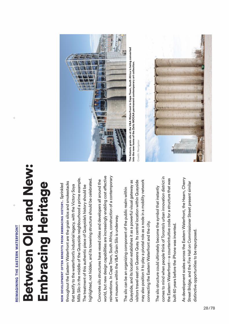
Betw
een
Old
and
New
: Em
brac
ing
Her
itage
The
hist
oric
gra
in s
ilo a
t the
V&
A W
ater
fron
t in
Cap
e To
wn,
Sou
th A
fric
a is
bei
ng c
onve
rted
in
to th
e ne
w h
ome
of th
e Ze
itz
MO
CA
A p
erm
anen
t con
tem
pora
ry a
rt c
olle
ctio
n.
Cre
dit:
Nav
igat
or
Vic
tory
Soy
a M
ills
Silo
at Q
uays
ide
Cre
dit:
Mar
k W
icke
ns
NEW
DEV
ELO
PMEN
T O
FTEN
BEN
EFIT
S FR
OM
EM
BRA
CIN
G H
ISTO
RY. S
prin
kled
th
roug
hout
the
East
ern
Wat
erfr
ont a
re th
e gr
ain
silo
s an
d sm
okes
tack
s th
at te
stify
to th
e w
ater
fron
t’s in
dust
rial l
egac
y, w
ith th
e V
icto
ry S
oya
Mill
s Si
lo in
the
mid
dle
of th
e Q
uays
ide
neig
hbou
rhoo
d a
prim
e ex
ampl
e.
The
trea
tmen
t of t
his
auth
entic
pie
ce o
f Qua
ysid
e’s h
isto
ry s
houl
d be
hi
ghlig
hted
, not
hid
den,
and
its
tow
erin
g st
ruct
ure
shou
ld b
e ce
lebr
ated
.
Con
cret
e si
lo s
truc
ture
s ha
ve v
exed
citi
es a
nd d
evel
oper
s al
l aro
und
the
wor
ld, b
ut n
ew d
esig
n ca
pabi
litie
s ar
e in
crea
sing
ly e
nabl
ing
cost
eff
ectiv
e re
inve
ntio
ns. I
n C
ape
Tow
n, S
outh
Afr
ica,
con
stru
ctio
n of
a c
onte
mpo
rary
ar
t mus
eum
with
in th
e V&
A G
rain
Silo
is u
nder
way
.
The
silo
can
be
an o
rgan
izin
g co
mpo
nent
of t
he p
ublic
real
m w
ithin
Q
uays
ide,
and
its
loca
tion
esta
blis
hes
it as
a p
ower
ful v
isua
l gat
eway
as
visi
tors
trav
el e
ast o
n Q
ueen
s Q
uay.
Its
cent
ral l
ocat
ion
with
in Q
uays
ide
may
als
o po
sitio
n it
to p
lay
a pi
vota
l rol
e as
a n
ode
in a
mob
ility
net
wor
k co
nnec
ting
the
East
ern
Wat
erfr
ont a
nd th
e ci
ty.
The
silo
str
uctu
re c
ould
ulti
mat
ely
beco
me
the
sym
bol t
hat i
nsta
ntly
co
mes
to m
ind
whe
n pe
ople
thin
k of
Tor
onto
’s ur
ban
inno
vatio
n di
stric
t in
the
East
ern
Wat
erfr
ont—
a co
unte
rintu
itive
cod
a fo
r a s
truc
ture
that
was
bu
ilt 6
0 ye
ars
befo
re th
e iP
hone
was
inve
nted
.
As
deve
lopm
ent s
cale
s ac
ross
the
East
ern
Wat
erfr
ont,
the
Hea
rn, C
herr
y St
reet
Brid
ge, a
nd th
e Fi
re H
all o
n C
omm
issi
oner
Str
eet p
rese
nt s
imila
r di
stin
ctiv
e op
port
uniti
es to
be
repu
rpos
ed.
28 / 78

51RE
IMA
GIN
ING
TH
E EA
STER
N W
ATE
RFRO
NT
TECH
IN
CU
BATO
R
URBA
N F
ARM
GARD
EN
TRAN
SIT
HU
B
HO
TEL
MU
SEU
MV
icto
ry S
oya
Mill
s Si
lo, a
n ic
on
of Q
uays
ide’
s in
dust
rial
pas
t,
may
wel
l bec
ome
a sy
mbo
l of
its
futu
re. T
he te
am a
t Sid
ewal
k ex
plor
ed a
ser
ies
of id
eas
that
w
ould
sim
ulta
neou
sly
pay
hom
age
to th
e si
te’s
heri
tage
w
hile
cre
atin
g a
beac
on
for i
ts in
nova
tive
futu
re.
29 / 78

10 RFP #2017-13: Innovation and Funding Partner for the Quayside Development Opportunity
WATERFRONT TORONTOMaster Developer
Waterfront Toronto is mandated to revitalize 800 hectares (2,000 acres) of brownfield lands on the waterfront into beautiful, sustainable mixed-use communities and dynamic public spaces. Waterfront Toronto will remain an active partner and investor in this and future phases of the Project through to its completion. Waterfront Toronto will work with the Partner in innovative and collaborative ways to ensure that Project objectives are met. The Partner will benefit from the expertise of its own project team, as well as the expertise and support of Waterfront Toronto, to meet the desired outcomes.
ARUP Canada Inc. Sustainable Systems and Technology Advisor
ARUP has expertise in sustainable systems and technology at both the building and precinct levels, as applicable to the planning and implementation of large, multi-phased, mixed-use developments. They have been and will continue to assist with establishing specific sustainability and innovation targets for the Project, as well as approaches for achieving these targets, including the ways in which Waterfront Toronto and its potential delivery partners might each contribute to these targets. Data-informed design and decision-making will be the foundation of this work, including modelling various scenarios in order to quantify the costs and benefits from ecological, social and economic perspectives.
KPMG LLP Process, Financial Analysis and Transactions Advisor
KPMG brings its expertise in process, transaction structuring and real estate finance to the Project. They have been and will continue to assist with refining an approach for attracting and securing partners in delivering the Project. This includes providing guidance on the appropriate sectors and types of companies to be engaged, potentially as partners; leading the market sounding with these parties; determining and structuring the most appropriate processes for securing their involvement; providing recommendations for the scale and phasing of the Project; and, determining and establishing appropriate deal structures for securing Waterfront Toronto's interests and achieving the overall Project objectives.
A.W. Hooker
Associates
(surveyors and cost consultants)
HR&A
(real estate, economic
development and public policy consultant)
Urban
Strategies Inc.
(planning and design firm)
N. Barry Lyons
Consulting
(multi-disciplinary real estate consulting)
Urban Strategies Inc.
(planning and design firm)
SUSTAINABILITY ADVISOR FINANCIAL ADVISOR
Figure 2. Team Composition
4. Partnership and Investment
Develop a new partnership model that ensures a solidfinancialfoundation,managesfinancialriskand secures revenue that funds future phases of waterfront revitalization.
IV. TeamIn setting objectives for this Project, two global firms(which,togetherwithWaterfrontTorontoandits other consultants, comprise the “Team”) were engaged through a competitive process to support
30 / 78
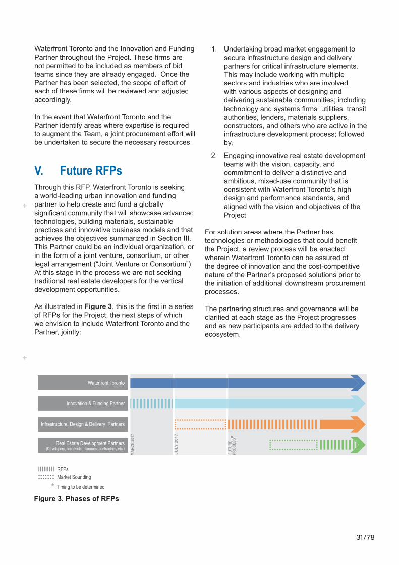
V. Future RFPsThrough this RFP, Waterfront Toronto is seekinga world-leading urban innovation and funding partner to help create and fund a globally significant community that will showcase advancedtechnologies, building materials, sustainable practices and innovative business models and that achieves the objectives summarized in Section III. This Partner could be an individual organization, or in the form of a joint venture, consortium, or other legal arrangement (“Joint Venture or Consortium”). At this stage in the process we are not seeking traditional real estate developers for the vertical development opportunities.
As illustrated in Figure 3, this is the first in a seriesof RFPs for the Project, the next steps of which we envision to include Waterfront Toronto and the Partner, jointly:
1. Undertaking broad market engagement to secure infrastructure design and delivery partners for critical infrastructure elements. This may include working with multiple sectors and industries who are involved with various aspects of designing and delivering sustainable communities; including technology and systems firms, utilities, transitauthorities, lenders, materials suppliers, constructors, and others who are active in the infrastructure development process; followed by,
2. Engaging innovative real estate development teams with the vision, capacity, and commitment to deliver a distinctive and ambitious, mixed-use community that is consistent with Waterfront Toronto’s high design and performance standards, and aligned with the vision and objectives of the Project.
For solution areas where the Partner has technologies or methodologies that could benefitthe Project, a review process will be enacted wherein Waterfront Toronto can be assured of the degree of innovation and the cost-competitive nature of the Partner’s proposed solutions prior to the initiation of additional downstream procurement processes.
The partnering structures and governance will be clarified at each stage as the Project progressesand as new participants are added to the delivery ecosystem.
Waterfront Toronto
Market Sounding
Infrastructure, Design & Delivery Partners
RFPs
MARC
H 20
17
JULY
201
7
Real Estate Development Partners(Developers, architects, planners, contractors, etc.)
FUTU
RE
PROC
ESS*
Innovation & Funding Partner
Timing to be determined*Figure 3. Phases of RFPs
Waterfront Toronto and the Innovation and Funding Partner throughout the Project. These firms arenot permitted to be included as members of bid teams since they are already engaged. Once the Partner has been selected, the scope of effort ofeach of these firms will be reviewed and adjustedaccordingly.
In the event that Waterfront Toronto and the Partner identify areas where expertise is required to augment the Team, a joint procurement effort willbe undertaken to secure the necessary resources.
31 / 78

Figure 5. The Subject Lands - Current Configuration
Parliament Development Lands(0.6 hectares/1.5 acres)
Figure 5 shows the current configuration of thesubject lands and the condition of the road network in this area. Currently, Parliament Street connects with Queens Quay East by running diagonally across the future Parliament Development Lands. The Parliament Development Lands will be created by the future realignment of Parliament Street south of Lake Shore Boulevard East and the extension of Queens Quay East across the north end of the Parliament slip (see Figure 4).
Waterfront Toronto has begun the planning and design for the realigned Parliament Street and the extension of Queens Quay East. This work will ultimately provide municipal services and utility infrastructure for the Parliament Development Lands and 333 Lake Shore Boulevard East.
These development lands comprise a number of land parcels, most of which are owned by the City of Toronto or Toronto Port Lands Company (TPLC), a City agency, with the exception of 307 Lake
ParliamentSlip
Inner Harbour
Parliam
ent S
t.
Smal
l St.
Queens Quay East
Bonn
ycas
tle S
t.GARDINER EXPRESSWAY (UPPER)/LAKE SHORE BLVD (LOWER)
Waterfront Toronto
Ownership
Municipal
Private
Shore Boulevard East which is privately owned and houses a two-storey office building. The maximummixed-use gross floor area permitted by the draftby-law for the publicly-owned lands is 425,000 square feet and for the privately-owned lands is 82,800 square feet. As a merged development site, the maximum mixed-use gross floor area permittedby the draft by-law is 574,000 square feet. City staffhave been consulted regarding the inclusion of the lands owned by the City and TPLC in this RFP. In the future, when development partners are being sought for the vertical development, the disposition of the publicly-ownded lands will require City Council approval.
333 Lake Shore Boulevard East(2.4 hectares/6.0 acres)
This vacant lot is owned by Waterfront Toronto and is currently used for parking. The draft by-law for 333 Lake Shore Boulevard East restricts the maximum mixed-use gross floor area toapproximately 930,000 square feet.
sour
ce fo
r all d
ocum
ents
: http
s://s
idew
alkt
oron
to.c
a/do
cum
ents
/
32 / 78

33 / 78
The Texts
All C
over
Imag
es: D
efau
lt ba
ckgr
ound
for G
oogl
e’s
Pixe
l 3 p
hone
. sou
rce:
ww
w.wa
llpap
erca
ve.c
om

34 / 78
CHRISTIAN VON BORRIESIn Conversation with Arno Brandlhuber and Olaf Grawert
OG: Lass uns vielleicht mit einem lokalen Fall beginnen und dann den Bogen auf globaler Ebene spannen. Zunächst bleiben wir in Deutschland, in Baden-Württemberg, dort wurdest du von der Kulturregion Stuttgart zu einer Kooperation mit lokalen Technologieunternehmen eingeladen und es kam zu einer Zusammenarbeit mit der Zukunftsabteilung Daimler Group. Warum baut einer der größten Autobauer der Welt auf die Expertise eines Künstlers und was versuchen sie aus deinem Artistic-Research über die Zukunft zu lernen?
CvB: Als Video-Künstler und Aktivist wurde ich von der Kulturregion Stuttgart, einer Unterabteilung der Wirtschaftsregion, angefragt. Kultur und Wirtschaft sind in dieser Region quasi eins – die hidden champions, wie Trumpf aber vor allem Bosch und Daimler dominieren und prägen diesen Raum.
Eine Firma erbittet also meine Expertise, den Blick von außen, eine andere Sicht auf unsere Umwelt, im Wissen, dass sich mit dem Wandel der Automobilindustrie, auch die Region ändern wird. Das Selbstverständnis dessen, was sie herstellen, von was sie geprägt und dominiert sind, ändert sich fundamental. Man könnte meinen: klar, die Autos der Zukunft werden nicht mehr aus Blech sein, das macht die Blechschneidemaschine von Trumpf obsolet, genauso wie das Elektroauto den Verbrennungsmotor überflüssig machen wird. Das ist uns allen klar, auch dass heute die Expertise für Schlüsseltechnologien im Automobilbereich in Japan, Südkorea und China liegt und nicht mehr in Deutschland. Das ist jedoch gar nicht der Punkt. Was ich in meiner Zusammenarbeit mit der Zukunftsabteilung von Daimler beobachten konnte, ist ein Wechsel der Vorstellungsorientierung: weg vom Autohersteller, hin zum Entwickler und Anbieter von Mobilitätskonzepten. Dieses Umdenken ist laut Daimler-Chef Zetsche entscheidend im Rennen um die Gestaltungshoheit von Mobilität, die das Unternehmen natürlich gewinnen will. Wenn ein Unternehmen wie Daimler über Mobilität spricht, spricht es automatisch auch über den öffentlichen Raum und dessen Gestaltungshoheit.
An diesem Punkt verschwimmen privatwirtschaftliche und öffentliche Interessen und das ist es, was mich als Künstler interessiert: das Verhältnis von Gesellschaft- zu Konzerninteressen – von Gemeinwohl- zu Gewinnabsichten. Wenn Stuttgarts Bürgermeister Kuhn im Rahmen einer Smart City Konferenz hin und her laviert zwischen, auf der einen Seite wollen wir den innerstädtischen Verkehr reduzieren, auf der anderen Seite sind die Arbeitsplätze für die Region wichtiger als „irgendwelche“ Mobilitätskonzepte, wird in diesem Moment das Scheitern der staatlichen Regulierungsmacht deutlich.
Nachdem Vortrag des regierenden Bürgermeisters folgte der Head of Daimler Financial Services, der größten Unternehmenssparte, der Miet- und Leasingbranche, mit seiner Vision von Arbeit und Mobilität für das Stuttgart der Zukunft – von der App über das Automobil bis zum Service selbst – alles aus einer Hand. Das Bild zur Vision ist besonders interessant, denn obwohl sie nicht wissen was sie bauen werden, ist die Zukunftsabteilung damit beschäftigt,

35 / 78
Renderings von Verkehrsknotenpunkten in Stuttgart zu machen, über denen Autos fliegen und Menschen auf Grünstreifen herumspazieren. Das visionäre Potential dieser Bilder beschränkt sich auf die Darstellung zweier Männer, die einen Kinderwagen schieben – sie denken, das ist eine wunderbare Zukunft, in Wirklichkeit sieht es aber aus wie Metropolis in Farbe. Diese Vorstellung einer alten Zukunft stelle ich in Frage, im Gespräch und in meinen Videoarbeiten, die sehr assoziativ sind. Es interessiert mich nicht fernsehtaugliche Recherche und Analyse zu betreiben. Daten statt Steuern.
OG: Im Filmgenre gibt es den Begriff der Ton-Bild-Schere, der das Auseinanderfallen von Bild und Erzählung beschreibt. Ähnlich verhält es sich mit der Erzählung von neuen Mobilitätskonzepten zu den von dir erwähnten Darstellungen. Gleichzeitig handelt und argumentiert Daimler natürlich als Unternehmen. In wie weit ist die zukünftige Stadt, die Smart City, eine rein unternehmerische und ökonomische?
CvB: Im Kern ist das relativ nahe an den Beobachtungen, die Orit Halpern in ihrem Buch The Smartness Mandate sammelt. Was ist das Versprechen dieser corporate smart cities und was hat es mit dieser Form von „Smartness“ auf sich? Das Smartness-Idiom betrifft viele Bereiche des täglichen Lebens – nicht nur die Art und Weise wie wir beginnen Städte neu zu denken – und basiert auf den Daten unseres öffentlichen Handelns. An diesem Punkt setzt Orit Halpern an, wenn sie von Daten als neuer Währung spricht, die Steuern ersetzen werden. Legen wir dieses Modell auf die Stadt um, wird die Benutzung der Stadt durch uns, durch die Bevölkerung, datafiziert. Unsere bisherige Freiheit sich im Stadtraum mehr oder weniger unbeobachtet zu bewegen, wird durch eine neue Form der Öffentlichkeit ersetzt, die in der Vernetzung unserer Geräte, Applikationen und Nutzungen gründet. Das reicht vom fitness tracker und der smart watch, über RFID chips in Kleidung und Geräten, bis hin zu neuronalen Prozessoren an denen geforscht wird. Das klingt nach Science-Fiction, ist aber Realität. Egal wie, die Öffentlichkeit trägt zur Generierung von Daten und Profilen bei, was zum Teil die Smart City ausmacht und unter dem Begriff Big Data zusammengefasst wird. und die Voraussetzung für künstliche Intelligenz bildet.
AB: Gleichzeitig beschränkt sich die Vorstellung von Daimler auf die mechanische Welt. Man ersetzt den Arbeiter, ob Mechaniker oder Mauerer und der Backstein wird nicht mehr per Hand, sondern mit dem Roboterarm platziert. Das hat aber gar nichts mit der Behauptung zu tun, Mobilität neu denken zu wollen, sondern beweist, dass der Übergang in eine andere Form noch undenkbar scheint. Etwas Ähnliches können wir gerade bei unseren Städten beobachten, denn was bisher mechanisch gedacht war, Material, Zirkulation, und so weiter – die Elemente unseres Habitats – verändert sich. Dein Künstlergespräch am Garage Museum in Moskau trug den Titel Algorithms of a Smart City and the disappearance of the architect. Bleiben wir beim ersten Teil des Titels: was bedeutet dieser Wechsel von der mechanischen in die digital-algorithmische Logik, für die Stadt und welche Rolle spielt Big Data?
CvB: Zwei Aspekte sind hier besonders wichtig: wer sammelt die Daten und wer wertet sie aus? Man könnte sagen, da ist die Gesellschaft vertreten durch den Staat. De facto sind es
36 / 78
aber, mit der Ausnahme von China, private Unternehmen. Wir alle hinterlassen Spuren in der Stadt: bei der Benutzung von öffentlichen Verkehrsmitteln, dem Einkauf im Supermarkt und dergleichen aufgezeichnet von Überwachungskameras. Bis dato stehen meine Handlungen jedoch in keinem direkten Zusammenhang zueinander. Was ich im Supermarkt kaufe oder wie viele Zigaretten ich rauche bleibt unbeobachtet. Im Gegensatz zu unserem virtuellen Verhalten, das zu personalisierter Werbung führt – ein Umstand dessen wir uns weitestgehend bewusst sind und den wir akzeptieren zu scheinen. In den USA und in China gibt es eine deutliche Tendenz, reale Handlungen zu vernetzen und in Bezug zu setzen. Die entscheidende Frage lautet: wer hat welche Interessen in der Auswertung dieser Daten des alltäglichen und öffentlichen Lebens?
Wenn das zum Beispiel eine gesetzliche Krankenversicherung ist, würde ich im besten Fall von guten Motiven ausgehen. Wenn es die Steuerbehörde ist, könnte man von einer Form der Gerechtigkeit sprechen. Bei privaten Konzernen ist die Motivation und Agenda weit weniger klar wobei der Schluss, dass es sich um Profitinteressen handelt, naheliegt. Hier würde ich auch den Wechsel von der mechanischen in die virtuelle Welt verorten. Am Beispiel selbstfahrender Autos sehen wir, dass die Unternehmen, die nicht selbst Autos bauen, sondern die Software herstellen, klar im Vorteil sind. Google ist neben chinesischen Entwicklern weltweit führend in dieser Technologie, auch ohne selbst Fahrzeuge zu bauen. Diese Leistung wird ausgelagert, das heißt es gibt eine klare Trennung zwischen Software und Hardware, wobei der entscheidende Mehrwert klar in der Implementierung des Betriebssystems liegt, also bei Google und nicht beim Autobauer.
OG: Es geht um die Ökonomisierung der Stadt durch Auswertung und Analyse des Nutzerverhaltens. Beispielsweise verwendet der erfolgreichste Investmentfonds der USA als Grundlage für seine Prognosen, die Parkplatzüberwachung der amerikanischen Supermarktkette Walmart. Automarke, Größe, Parkdauer, Frequenz geben Aufschluss über die Wirtschafts- bzw. Kaufkraft und die Entwicklungsperspektive einer Nachbarschaft und dienen zur Validierung der Vertrauenswürdigkeit eines Finanzprodukts. Gleichzeitig ist es eines der größten und günstigsten Datensets.
AB: Es geht um die Frage der Sinngebung – wo passiert der qualitative Übergang? Die Daten sind vorhanden, einfach verfügbar und in gewisser Weise austauschbar. Niemand hat sich bewusst für die Verwendung der Daten durch dritte Parteien entschieden, als vor 20 Jahren Kameras auf den Parkplätzen installiert wurden. Erst zunehmend selbstlernende Analysesoftware hat wie in diesem Beispiel deutlich wird die Ebene der Daten freigelegt. Was passiert, wenn diese großen Datensätze, seien es zufällige, von Google generierte oder im Fall Chinas, staatliche, auf die die alte analoge Stadt und Stadtplanung treffen?
CvB: Das Beispiel vom Parkplatz zeigt die gelungene Vernetzung von Daten. Gleichzeitig kann man daran festmachen, dass nicht die Softwareentwickler, sondern die Datenanalysten entscheidend sind. Ein Datenanalyst ist kein Programmierer, sondern eine Person, die in der Lage ist, durch Datenmuster Zusammenhänge im Verhalten von Personen und Objekten herzustellen.Nehme ich das Auto, das Fahrrad oder gehe ich zu Fuß? Verlasse

37 / 78
ich das Haus überhaupt? Mit wem spreche ich im Bus? Man könnte jetzt positiv sagen, die bisherige Stadt wurde an den Bewohner*innen vorbeigeplant. Die Verantwortung wurde zentralisiert, zum Beispiel wo wie viele Sozialwohnungen gebaut oder an Private verkauft werden. Die Stadt der Zukunft beruht eventuell auf dem Datensatz der Bevölkerung deren Input unterschiedlichster Art, in die Art und Weise, wie die Stadt der Zukunft aussehen wird, miteinfließt.
Gleichzeitig verschiebt sich unsere Rolle vom Bürger zum User, um den Begriff zu bemühen und wir sind nicht mehr Teil einer Gesellschaft, sondern einer „Community“, einer homogenen Blase. Dass diese Ökonomisierung der Umwelt durch private Unternehmen im Westen nicht als Bedrohung wahrgenommen wird, zeigt das Beispiel der Toronto Waterfront zeigt das ganz deutlich. Dort entwickelt Sidewalk Labs, ein Tochterunternehmen von Alphabet und Schwesterunternehmen von Google, einen ganzen Stadtteil. Wir müssen uns fragen, wie sich die Interessen von Alphabet, abgesehen von Konzern- und Profitinteressen, von einer ideal gedachten Stadtverwaltung unterscheiden.
Daten als Macht
OG: Lass uns bei dem Beispiel Toronto Waterfront bleiben. PPP-Modelle sind auf dem Vormarsch, immer mehr Infrastruktur und Stadtbauprojekte werden in public-private-partnerships gedacht und umgesetzt. In Deutschland gibt es ein ähnliches Werkzeug, städtebauliche Verträge, was bedeuten diese Allianzen der gewählten Vertretungen mit privaten Unternehmen für die Stadt? Den Rückzug des Staates, wie wir ihn kennen?
CvB: Das ist eine sehr interessante Frage. Es wäre zu einfach zu sagen, weil es Google ist, ist es per se schlecht. Wir sind uns der Chancen und des Nutzens des Service bewusst. Google erleichtert zweifellos unser aller Leben – das ist ein Fakt – und jetzt baut Google einen ganzen Stadtteil von Toronto. Der Schritt aus der digitalen in die analoge Welt ist absolut logisch. Das erste Indiz waren die physischen Präsenzen der großen Technologieunternehmen auf dem World Economic Forum 2018 in Davos. Ich reise jedes Jahr als Beobachter in die Schweiz und zum ersten Mal hatten Google, Facebook und Palantir – darüber möchte ich später noch etwas sagen – eigene Gebäude in bester innerstädtischer Lage gebaut/bezogen. Das klingt erstmal nicht weiter ungewöhnlich doch, wenn man das Forum kennt, weiß man welcher Ausdruck von Macht ein mehrstöckiges Gebäude zwischen dem Kirchner Museum und dem Hotel von Donald Trump und Angela Merkel darstellt.
Die Unternehmen reihten sich neben die Nationalstaaten, mit dem Unterschied, dass der Zutritt zu ihren Repräsentanzen beschränkt war. Wer zu ihnen „nach Hause“ wollte, brauchte eine Einladung. So ein Moment wird im Westen kaum wahrgenommen oder kommentiert. Genauso wenig, dass der CEO von Sidewalk Labs, Dan Doctoroff, ganz explizit ein wirtschaftliches Interesse an Stadt formuliert. Nicht als Anlagewert, sondern als Datenpool. Wer die Daten hat, hat die Macht und wer die Macht hat, hat das Sagen – wie wir funktionieren, handeln uns bewegen – das kommt in der analogen Welt an und das ist der Moment, in dem wir uns gerade befinden. Wenn wir das jetzt mit China vergleichen und den Unterschied studieren, ist das natürlich höchst interessant.

38 / 78
Denn dieser moralische und auch politisch gedachte Unterschied zwischen Privatunternehmen und Staat, der existiert dort nicht. In einem zentralistischen Staat wie China fällt das zusammen. Die großen Internetunternehmen sind zwar privatgeführt und an der US Börse gehandelt, doch befinden sie sich immer mehrheitlich in staatlicher Hand. Was zu einem Informations- und Datenmonopol des Staates und Regimes führt. Dieser hat seinen Anteil am Entwicklungsstand neuer Technologien, Algorithmen und KI. Außerdem ist die Angst der Bevölkerung, soweit ich das von meinen zahlreichen Aufenthalten und Gesprächen beurteilen kann, wesentlich kleiner. Dort herrscht weniger die Angst vor dem Big Brother, als die Hoffnung auf eine Form der Objektivierung dessen, wie ein Staat, ansonsten vielleicht willkürlich, eigenmächtig aber auch korrupt handelt.
AI is Communist
AB: Peter Thiel, Gründer von Paypal und Palantir, sagt: crypto ist libertarian und AI ist communist. Du bringst das Zitat in deinem Film, was meint er damit?
CvB: Dazu muss man wissen, dass Peter Thiel libertär ist und er sich gegen China als zentralistischen Staat und für crypto als dezentrales System ausspricht. Für ihn ist der Gedanke einer zentralen Intelligenz per se autoritär und deshalb communist. Damit wäre eine AI basierte und gesteuerte Smart City, wie sie auch Google denkt, eine Form von autoritärer Staat. Gleichzeitig zeigen sich Aspekte eines neuen kalten Krieges, nicht zuletzt um Ressourcen, denn beide Technologien verschlingen Unmengen an Energie was direkte Auswirkungen auf die betroffenen Staaten hat. China steuert als einziges Land dagegen, was den libertären Kräften ein Dorn im Auge ist.
Für Peter Thiel geht es aber auch um eine Idee von physischer Gesellschaft. Wenn sie von crypto sprechen beziehen sie sich immer auch auf Milton Friedman, den Ökonomen und Ronald Reagan Vertrauen und seine marktlibertären Ansätze die jegliche staatliche Kontrolle aufheben wollen. Der Staat wird degradiert und dient lediglich noch zum Schutz des Privateigentums — nicht das der Mob kommt und dir dein Eigentum wegnimmt. In ihrer Logik ist der nächste Schritt, sich auf schwimmende Inseln außerhalb nationalen Hoheitsgebietes zurückzuziehen, das nennt sich dann seasteading - der Inbegriff einer libertären Gesellschaft, wobei jegliche Variation von Gesellschaftssystem mögliche ist. Das könnte ein sozialistischer Staat sein, es könnte auch ein autoritärer Staat sein.
OG: Algorithmen sind ja nicht Gott-gegeben – dahinter stehen Menschen die ihre eigenen Motivationen, Vorurteile und Agenden verfolgen. James Bridle schreibt in seinem Buch New Dark Age: Technology and the End of the Future unter anderem über die Einflusssphäre der Entwickler und Analysten. Safiya Noble wirft in ihrem Buch Algorithms of Oppression die Frage der Agency der Coder und Codes auf.
AB: Wendy Chun führt den Begriff der Homophilie ein, um den Facebook Algorithmus zu erklären. Dieser folgt der Logik des Unternehmens und versucht Menschen in möglichst homogene Gruppen einzuteilen, weil diese leichter zu adressieren sind. Ist die Smart City per se homogen?

39 / 78
CvB: Machine Learning beruht auf Statistik. Statistik von Nutzerdaten, von bestehenden Räumen, Situationen, Umfeldern. Statistik bedeutet in der Marktlogik jedoch auch, dass der größte Haufen immer größer wird und werden muss. Und das ist natürlich ein riesen Problem in der Entwicklung von künstlicher Intelligenz durch Machine Learning. Minderheiten werden marginalisiert, was eine Gefahr ist, genau wie die fehlende accountability – Rechenschaftspflicht. Wir wissen nicht wie AI funktioniert. Wir können nicht intervenieren oder widersprechen, was weiter zur Homogenisierung des Einzelnen und der Gesellschaft beiträgt. Um auf die Frage zurückzukommen, ob die Smart City wie Facebook per se homogen ist, muss man fragen wie Facebook den Staat und die Stadt denken und verstehen würde. Das ist alles höchst spekulativ, vielleicht schauen wir auf die physischen Räume die Facebook bis dato für sich erdacht hat und welcher Logik diese folgen. Frank Gehrys Entwurf für die Firmenzentrale von Facebook ist deshalb so interessant, weil das Unternehmen zwar auf den bekanntesten Trademarkarchitekten setzt, nicht jedoch auf sein Markenzeichen, seine ikonische Architektursprache. Völlig untypisch im Sinne Gehrys, aber ganz im Sinne von Facebook –eher so wie Mark Zuckerburg angezogen ist – nach dem Prinzip Normcore. Entstanden ist eine Architektur, die etwas antizipiert, nämlich scheinbare architektonische Unbestimmtheit versus City-Marketing Bilbao. Genau wie die Ikea-Lampe und das H&M Shirt geht es um den kleinsten gemeinsame Nenner auf den man sich einigen kann, der global funktioniert und reproduziert werden kann.
Einen ähnlichen Grad der Unbestimmtheit sehen wir bei Toronto Waterfront. Es war eine bewusste Entscheidung für den Standort Toronto und gegen die USA. Etwas zwischen dem europäischen Regulativ und den privat-kapitalistisch geführten Vereinigten Staaten. Ein Hybrid-Standort der als Testfeld gedacht werden kann, global funktioniert und gleichzeitig einen hohen Grad an Mitbestimmung antizipiert, was natürlich wichtig ist. In Toronto ist eine andere Form der Datengenerierung als in den USA möglich – eine freiwillige, pro-aktive und beidseitige. Das führt im ersten Schritt zu Architekturen die, ähnlich der IKEA Lampe, niemanden stören und vorstellungsoffen für alle sind.
AB: Wenn wir davon ausgehen, dass die Bilder von Architekturen in diesem Fall nur dazu dienen eine Resonanzen zu erzeugen, die als Daten in die Stadtplanung einfließen, wird Architektur zum Instrument, bei gleichzeitigem Verlust ihrer sozialen Funktionen. Es geht nicht darum ein Bild, eine Skizze einzunehmen. Das hieße aber auch, dass Architektur, wie wir sie bisher denken, nur noch eine Resonanzfunktion hat, nicht aber mehr eine Planungs- oder soziale Funktion.
CvB: Genau! Architektur wird im ersten Schritt zum Instrument der Statistik und gibt Aufschluss über das Nutzerverhalten. Ganz anders als die Renderings von Daimler sehen die Bilder von Sidewalk Labs wie Kinderzeichnungen aus. Sie wollen der Entscheidung des Nutzers nicht vorgreifen, ob ein Auto über der Kreuzung fliegt oder wer den Kinderwagen schiebt. Die Rolle des Architekten gibt es in diesem Szenario nicht mehr, beziehungsweise beschränkt sich ihre Einflusssphäre auf die Gestaltung einzelner Punkte im Stadtraum, die vom Algorithmus vorbestimmt sind.

40 / 78
User und Provider
OG: Neben Orit Halpern beziehst du dich in deinen Vorträgen auch auf Keller Easterling mit der wir ebenfalls gesprochen haben. Ihr stimmt in der Aussage überein, dass es zu einer Marginalisierung gewisser unerwünschter Bevölkerungsgruppen kommt, in der Regel der Arbeiter. In deinem Film zeigst du Bilder des Louvre Abu Dhabi in dem Arbeiter fast unsichtbar stehen und warten, damit assoziierst du eine Trennung in dienende und nutzende Schicht. Wie siehst du den Zusammenhang?
CvB: Ich sammle ja schon seit Jahren Aufnahmen von putzenden Menschen – die sozusagen sinnlos putzen. Wir alle nutzen Car Sharing Services, aber niemand weiß, wer die Autos putzt, tankt oder wartet. Es muss auch die Arbeiter geben, die man nicht sehen sollte, die das Elektroauto aufladen, putzen, den Reifen wechseln und kommen, wenn deine Smartwatch nicht funktioniert oder dein Chip kaputt ist. Auf Dauer wird dieses Klassensystem und die neoliberale Politik die dahintersteht nicht bestehen können. Wir haben in der westlichen Welt gut 70 Jahre Frieden, das ist die Ausnahme. In einer ohnehin ungewissen Zeit, an dem Punkt, an dem Gesellschaften auseinanderfallen – hier die Reichen, dort die Armen – kommen diese neuen Formen und Ideen von Lebenswelten hinzu.
Die Frage ist wie Unternehmen und Start-Ups, auf die heute stattfindende Verdrängung der Mittelschicht aus den Innenstadtbereichen reagieren. Google, Amazon oder Beidu haben keinen Vorteil davon, wenn ihnen die Käuferschicht davonbricht. Sie wollen Geld verdienen und man kann davon ausgehen, dass sie Ghettobildung jedweder Art verhindern werden. Die Frage ist, wie kann ein Algorithmus dem entgegenwirken?
Big Data als öffentlicher Raum
AB: Sidewalk Labs verwendet eine selbst entwickelte open-source Software namens „Doppelganger“ zur Simulation und Planung ganzer Städte, die Kommunen und Stadtplanern zur Verfügung gestellt wird. Im Gegenzug erhalten sie geprüfte Daten zurück, die zur Verifizierung ihrer eigens generierten auf Echtzeit-Daten basierten, algorithmischen Prognosen dienen. Was bedeutet dieses Vordringen von Big Data für uns, als Bürger*innen und die Stadt, im speziellen den öffentliche Raum?
CvB: Big Data als öffentlicher Raum, das ist natürlich eine entscheidende Frage. Bis vor gar nicht allzu langer Zeit lebten wir in der Vorstellung der öffentliche Raum gehöre allen. Den Zwischenschritt markierten Räume in den Metropolen des Kapitals, von New York bis Shenzhen. Dort standen vor dem Apple Store Bertoia Stühle um Springbrunnen und wenn man sich hinsaß und eine Zigarette anzündete, kam der private Sicherheitsdienst und erklärte einem, dass Rauchen auf dem Apple Square verboten sei. Das war und ist eine Form von Öffentlichkeit, in bester Lage, die mit unserer Vorstellung davon jedoch wenig gemein hat. Randgruppen haben keinerlei Anspruch auf diesen Raum. Obdachlose werden sofort verscheucht. In Berlin gibt es das jetzt auch. Ich war bei der Eröffnung des Mercedes-Benz-Platzes, vor der O2-Arena, jetzt die Mercedes-Benz-Arena. Eröffnet wurde der Platz von Ramona Pop, Wirtschaftssenatorin der Stadt Berlin mit den Worten: „Das ist

41 / 78
ein typisches Berliner Quartier, wie wir es uns wünschen.“ An der Straße standen Polizisten, die auf meine Nachfrage bestätigten, was mir ohnehin klar war. Kein Zutritt für die Beamten auf das Gelände, da es sich um einen privaten Raum handelt und Sicherheit privat gedacht und geregelt wird.
Dieser Zwischenschritt von öffentlich zu scheinbar-öffentlich ist insofern wichtig, als dass das unbemerkte Ankommen diese Form von Raum und dessen Akzeptanz den Übergang für Big Data als öffentlicher Raum markiert. Das ist ein schwieriger Gedankengang, weil Daten etwas Nicht-physisches und Raum etwas Physisches ist. Aber in der Vorstellung generiert der öffentliche Raum diese Daten.
Die Fußballweltmeisterschaft in Russland ist ein gutes Beispiel. Dort wurde flächendeckend eine Gesichtserkennungssoftware namens Findface verwendet, mit einer Erkennungsrate von 97%. Alle, die zur Fußballweltmeisterschaft kamen, hatten RFID-Chips in ihren Besucherpässen, die man auch außerhalb der Stadien tragen musste. Das klingt wieder nach alter Technologie, antizipiert jedoch schon eine Zukunft, in der wir mit Chips Grenzen überschreiten können, nicht mehr in der Schlange stehen müssen, im Supermarkt zahlen können – sprich, reibungs- und grenzenlos leben werden. Den Kritikern der Technologie entgegnete man mit dem Sicherheits-Argument, dem Abgleich mit Daten bekannter Hooligans. Ähnlich argumentiert China gegenüber Kritikern des Sozialpunkte-Kontos. Dort ist Big Data schon der öffentliche Raum und Teil der Lebensrealität. Wer sich unangemessen verhält darf den Schnellzug nicht benutzen. Argumentiert wird immer mit Randgruppen, die man überführen will. Dies sind Beispiele anhand derer ersichtlich wird, wie Daten öffentlichen Raum beeinflussen.
AB: Keller Easterling spricht in ihrem Buch von Extrastatecraft – Kräfte die sie in Verbindung mit der physischen Welt bringt. Deinem Beispiel zu folge, gibt es keine Nationalstaaten in Europa, die mit der Übermacht globaler Tech-Unternehmen konkurrieren könnten.
CvB: Genau, die ähnlich groß wären oder über ähnliche Mittel verfügen. Deswegen habe ich auch einen Film über Apple in China gemacht. Rückblickend war das ein altmodischer Gedanke: Apple ist Hardware versus China als Hardware. Heute würde ich natürlich sagen China ist Software versus die Tendenzen und Entwicklungen von Sidewalk Labs. Wir müssen darüber nachdenken, die Technologieunternehmen die wir mit Staaten vergleichen, mit supra-staatlichen Strukturen zu belegen und zu kontrollieren. China ist die Ausnahme, weil der Staat zentral, also top-down organisiert ist. Das ist politisch gesehen nicht die Regel, technologisch gibt es jedoch eine klare Tendenz in diese Richtung. Unsere Technologien haben diese Tendenz eingeschrieben. Jetzt könnte man fragen, was ist die Funktion des Architekten in China? Wenn wir zurück kommen zu Sidewalk Labs, wissen wir nicht genau was die Rolle des Architekten dort ist. Sie stellen keine Architekten ein, zumindest nicht per Definition. Diese Funktion würde wahrscheinlich ausgelagert und vergeben werden.
Gesellschaft und ihre Architektur als Algorithmus
OG: Die Stellenbeschreibungen auf der Website von Sidewalk Labs geben einen Einblick in die Rollenbilder des Unternehmens.

42 / 78
Es geht um Software, es geht um ein ganzheitliches Verständnis, es geht um Leistungsziele, es geht darum zu verstehen, was man mit den Daten machen kann. Und findest du keinen passenden Job auf der Website von SidewalkLabs, dann „schau doch bei unserem Schwesterunternehmen vorbei“: Cord, steigert die Mobilität in der Stadt; Cityblog, bringt Gesundheit und Technologie zusammen; Intersection, vernetzt die digitale mit der physischen Welt; und so weiter.
AB: Der CEO von Sidewalk Labs, Dan Doctoroff, war in seiner Rolle als Deputy Major in New York für die Implementierung von LinkNYC verantwortlich. Die LinkNYC Kioske ersetzten alle Telefonzellen und bieten freies Wifi in ganz New York. LinkNYC gehört ebenfalls mehrheitlich der Alphabet (Gruppe), weshalb es scharfe Kritik aus der Zivilbevölkerung gab. Wie kann man angesichts dieser überbordenden Wirtschaftsmacht überhaupt noch in einen Dialog auf Augenhöhe treten?
CvB: Wenn man die Vielschichtigkeit des Unternehmens und dessen Tragweite verstehen will, müsste man eine zweite Linie einziehen und fragen, was sind die bisherigen Entsprechungen und gesellschaftlichen Funktionen, zu den Technologien und Angeboten die Alphabet macht? Das wäre der öffentliche Nahverkehr, ein öffentliches Krankenhaus, eine öffentliche Krankenkasse. Im Projekt Toronto Waterfront werden diese staatlichen Funktionen durch private Unternehmen ersetzt. Jetzt könnte man sagen, ja klar Privatisierung, kennen wir doch. Darum geht es den Unternehmen aber nicht. Es geht ihnen um den vollumfänglichen Zugang zu unseren Lebensräumen und um die subkutane Steuerung unseres Verhaltens.
Man muss das Geschäftsmodell verstehen. In der Vorstellung von Google sind alle städtischen und staatlichen Funktionen scheinbar kostenlos, wie eine Suchanfrage. Die privatisierte Leistung ist lediglich das Werkzeug um, wie auch schon bei der Suchanfrage, Daten als Gegenleistung zu erhalten.
Also ist die Frage, wo der Architekt eintreten kann, vielleicht zu kurzgefasst. Vielleicht muss man eher fragen, wo ist die Gesellschaft? Was man nicht kann und das habe ich aus meiner Arbeit mit Programmieren und Entwicklern gelernt, ist unabhängig vom System zu agieren. Das heißt, zu glauben man könnte unabhängig von Alphabet, Amazon und Co. etwas an der Situation ändern. Genau das Gegenteil ist der Fall, man muss ihre Werkzeuge benutzen und sich überlegen, was könnten wir damit machen und was könnte unsere Funktion sein. Ihr seid doch Architekten, die Software steht euch zur Verfügung, benutzt sie und schaut was dabei rauskommt und was das für euch bedeutet. Ich glaube das ist die einzige Möglichkeit. Damit ist man embedded und es gibt wahrscheinlich gar keine Alternative. Aber es erweitert im besten Fall den Horizont dessen, was wir uns vorstellen können.
Ganz positiv gesagt, vielleicht ist Toronto Waterfront letztendlich die Architektur, die den Pritzkerpreis gewinnt, weil sich kein Architekt jemals hätte vorstellen können, was dabei rauskommt. Vielleicht gibt uns Big Data eine Vorstellung von Gesellschaft, auf die wir selbst nie gekommen wären, auf die Google selbst nicht gekommen wäre. Denn nachvollziehen was AI generiert können letztendlich weder Google, Tencent oder Baidu — wir aber schon, wenn wir mit dem Resultat konfrontiert werden.
PROLOGUE_Speculating on Sense
This book is about the historical construction of vision and cognition in the second half of the twentieth century. It posits that our forms of attention, ob-servation, and truth are situated, contingent, and contested and that the ways we are trained, and train ourselves, to observe, document, record, and analyze the world are deeply historical in character. The narrative traces the impact of cybernetics and the communication sciences after World War II on the social and human sciences, design, arts, and urban planning. It documents a radical shift in attitudes to recording and displaying information that produced new forms of observation, rationality, and economy based on the management and analysis of data; what I label a “communicative objectivity.” Furthermore, the book argues that historical changes in how we manage and train perception and define reason and intelligence are also transformations in governmen-tality. My intent is to denaturalize and historically situate assumptions about the value of data, our regular obsession with “visualization,” and our almost overwhelming belief that we are in the midst of a digital- media- driven “crisis” of attention that can only be responded to through recourse to intensifying media consumption.
To begin to interrogate this past and its attendant stakes, I would like to offer an example in the present. I want to open with the largest private real estate development on earth.1 One hour’s drive southwest from Seoul, the new city of Songdo is being built from scratch on land reclaimed from the ocean (fig. P.1).2 It is a masterpiece of engineering, literally emerging from a pre-viously nonexistent territory. Beneath this newly grafted land lies a massive infrastructure of conduits containing fiber optic cables. Three feet wide, these tunnels are far larger than in most western European and American cities. They are largely empty spaces waiting, in theory, to provide some of the high-est bandwidth on earth. To the eye of a New Yorker this is a strange landscape of inhuman proportions. Nowhere in the United States are there construction sites even approximating this size.
Part of the newly established Incheon Free Economic Zone (IFEZ), Songdo is one of three developments— the other two go by the labels “logistics” and
Orit
Hal
pern
, Pro
logu
e, B
eaut
iful D
ata:
A H
isto
ry o
f Vis
ion
and
Reas
on S
ince
1945
. Dur
ham
:Duk
e U
nive
rsity
Pre
ss, 2
014.
43 / 78
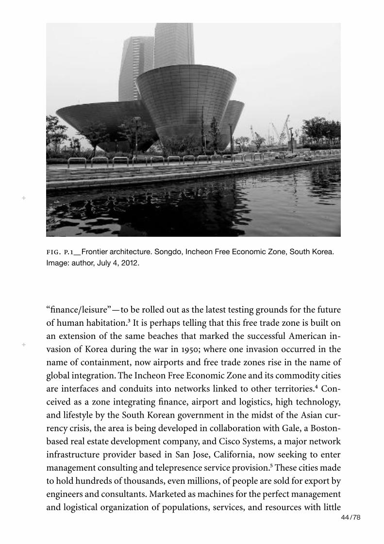
2_PROLOGUE
“finance/leisure”— to be rolled out as the latest testing grounds for the future of human habitation.3 It is perhaps telling that this free trade zone is built on an extension of the same beaches that marked the successful American in-vasion of Korea during the war in 1950; where one invasion occurred in the name of containment, now airports and free trade zones rise in the name of global integration. The Incheon Free Economic Zone and its commodity cities are interfaces and conduits into networks linked to other territories.4 Con-ceived as a zone integrating finance, airport and logistics, high technology, and lifestyle by the South Korean government in the midst of the Asian cur-rency crisis, the area is being developed in collaboration with Gale, a Boston- based real estate development company, and Cisco Systems, a major network infrastructure provider based in San Jose, California, now seeking to enter management consulting and telepresence service provision.5 These cities made to hold hundreds of thousands, even millions, of people are sold for export by engineers and consultants. Marketed as machines for the perfect management and logistical organization of populations, services, and resources with little
FIG. P.1_Frontier architecture. Songdo, Incheon Free Economic Zone, South Korea.
Image: author, July 4, 2012.
44 / 78
PROLOGUE_3
regard for the specific locale, these products are the latest obsession in urban planning.6 They are massive commodities.
Songdo is a special class of such spatial products. The city’s major distin-guishing feature is that it is designed to provide ubiquitous physical com-puting infrastructure. Marketed as a “smart” city, it is sold as the next frontier in computing— an entire territory whose sole mandate is to produce inter-active data fields that, like the natural resources of another era, will be mined for wealth and produce the infrastructure for a new way of life. Cisco’s stra-tegic planners envision the world as interface, an entire sensory environment where human actions and reactions, from eye movements to body move-ments, can be traced, tracked, and responded to in the name of consumer satisfaction and work efficiency (whatever these terms may denote, and they are always ill defined and malleable, as are, perhaps not incidentally, “intelli-gence” or “smartness”).7 Every wall, room, and space is a conduit to a meeting, a building, a lab, or a hospital in another place. The developers thus envision an interface- filled life, where the currency of the realm is human attention at its very nervous, maybe even molecular, level. (Engineers speak candidly of transforming the laws of South Korea to allow the construction of medical grade networks to allow genetic and other data to flow from labs in the home to medical sites in order to facilitate the proliferation of home- health care ser-vices.) Accompanying the provision of computing infrastructure, the South Korean government also offers tax incentives to global high- tech and biotech-nology companies to build research and development facilities that leverage the data structures and bandwidth of the location. Samsung’s biotech division has already relocated, along with POSCO, a major steel refining conglomerate, IBM/KYOBO e- book storage and web sales, Cisco’s urban management divi-sion, and numerous other companies.8
As some of the city’s more enthusiastic proponents write, “as far as play-ing God. . . . New Songdo is the most ambitious instant city since Brasília 50 years ago. . . . It has been hailed since conception as the experimental proto-type city of tomorrow. A green city, it was LEED- certified from the get- go, de-signed to emit a third of the greenhouse gases of a typical metropolis its size. . . . And it’s supposed to be a ‘smart city’ studded with chips talking to one another.” The article goes on to address the role of Cisco in the project and their plans to “wire every square inch with synapses.”9 The developers, finan-ciers, and media boosters of this city argue for a speculative space ahead of its time that operates at the synaptic level of its inhabitants, linking the manage-ment of life at a global and ecological level to the very modulation of nerves.
45 / 78

4_PROLOGUE
The government and the corporations developing this space hope to create value around this systemic (human, machine, and even environmental) atten-tive capacity. They speak of “monetizing” bandwidth, implying that terms like “information” and “communication” can be seamlessly translated into rates of bits transmitted10 and into the amount of attentive, even synaptic, time con-sumers dedicate to unspecified applications in business, medicine, and edu-cation.11 This is a landscape where bandwidth and sustainability are fantasized as organizing life through a proliferation of interfaces to the point of ubiquity (fig. P.2). What constitutes “intelligence” and “smartness” is now linked to the sensorial capacity for feedback between the users and the environment: band-width and life inextricably correlated for both profit and survival.
Songdo arguably demonstrates a historical change in how we apply ideas of cognition, intelligence, feedback, and communication into our built environ-ments, economies, and politics. It is a city that is fantasized as being about re-organizing bodies, down to the synaptic level, and reorienting them into global data clouds or populations with other similarly reorganized nervous systems globally.12 These populations are not directly linked back to individual bodies but are agglomerations of nervous stimulation; compartmentalized units of an individual’s attentive, even nervous, energy and credit.13 Furthermore, it is imagined as a self- regulating organism, using crowdsourcing and sensory
FIG. P.2_Bandwidth = Life. Image of control room in Songdo, monitoring
environmental data, traffic movement, security cameras, and emergency response
systems. Image: author, September 1, 2013. As the marketers explain: “life in the
Incheon Free Economic Zone is peaceful and abundant with parks and broad fields of
green covering more than 30 percent of the city. There is a new city waste incinerating
facility, a treated sewage recycling system and other systems, which work beyond
eyeshot.” Incheon Free Economic Zone marketing materials, July 2012.
46 / 78

PROLOGUE_5
data to administer the city and limit (in theory) the necessity for human, or governmental, intervention. Songdo’s speculators who are banking on the big data sets to be collated from such spaces no longer deal with consumers as individual subjects but rather as recombinable units of attention, behavior, and credit. This form of political economy is often labeled “biopolitics” for making life its object and subject of concern, and it produces a range of new forms of administration, management, and productivity.14
The fantasy of managing life itself by bandwidth, and the often unques-tioned assumption that data presents stability, wealth, and sensorial pleasure is not solely the privy of real estate speculators. Today “big data” is regularly touted as the solution to economic, social, political, and ecological problems; a new resource to extract in a world increasingly understood as resource con-strained.15
This ubiquitous data that is so valuable, even without a set referent or value, is also often explicitly labeled “beautiful.” In the pamphlets of tech-nology corporations touting the virtues of a “smart” planet and in prominent textbooks in computer science and blogs by computer research groups, stories abound about “elegant data solutions.” These narratives come with labels such as “Beautiful Data” and “Beautiful Evidence.” Opening with the premise that the web today is above all about the collection of personal data, many data visualization sites and textbooks urge the designers, engineers, and program-mers of our future to address the important aesthetic component of making this data useful, which is to say, “beautiful.” But data is not always beautiful. It must be crafted and mined to make it valuable and beautiful.16 Despite the seeming naturalness of data and its virtues, therefore, there is nothing auto-matic, obvious, or predetermined about our embrace of data as wealth. There is, in fact, an aesthetic crafting to this knowledge, a performance necessary to produce value.
These discourses of data, beauty, and “smartness” should, therefore, present us with numerous critical historical questions of gravity, such as: how did space become sentient and smart? How did knowledge come to be about data analysis, perhaps even in real time, not discovery? How did data become “beautiful”? How did sustainability and environment come to replace struc-ture, class, and politics in the discourses of urban planning, corporate market-ing, and governmental policy? To summarize, how did perception, understood as a capacity to consume bandwidth, come to reorganize life itself ?
There is much at stake in these questions. In tying the management of the future of life so tightly to computation and digital media, Songdo is a par-ticular instantiation of how emerging infrastructures of knowledge and per- 47 / 78

6_PROLOGUE
ception are involved in the reformulation of population and in the transfor-mation, if not disappearance, of space and territory. But these cities are also massive prototypes, not- yet- realized instantiations of futures that may or may not come to pass. Part of rethinking these futures is renegotiating their past.
The philosopher and cultural critic Walter Benjamin was among the most prominent thinkers to realize that a history of perception can transform the future. “Architecture,” he once wrote, in his essay on art in the age of mechani-cal reproduction, “has always represented the prototype of a work of art the reception of which is consummated by a collectivity in a state of distraction. The laws of its reception are most instructive.”17 For Benjamin architecture was the spatial key to a temporal problem— how to denaturalize the present and thus reimagine the future? The laws of reception stipulated by Benjamin, however, can no longer be received, as they hide inside protocols, storage banks, and algorithms. The terms “attention” and “distraction” are inadequate to describe a sensorium now understood as infinitely extendable.
I have opened, therefore, with this example that is seemingly distant from any history of cybernetics, visuality, or reason because it demonstrates the complexity and urgency of interrogating this present and its biopolitical ratio-nalities. But Songdo is a disposable architecture, whose material manifesta-tions are banal and constantly mutating. The city is not a space full of top
FIG. P.3_Visible: demonstration control room, Tomorrow City, Songdo. Image: author,
July 4, 2012. Ubiquitous: “smart” ubiquitous home prototype; the table and the walls
are all projection- responsive interfaces, along with sensors for environmental control
and telemedicine, at SK Telcom “U” (for ubiquitous) products showroom, Seoul.
Image: author, July 3, 2012. Smart: “smart” pole, with sensors installed for movement
detection, Internet wi- fi hotspot, surveillance cameras and sensors linked to police,
fire, and hospital for emergencies, and “smart” LED screens. The poles play music to
passersby, provide direct- to- consumer advertising, and enhance, according to ➞
48 / 78

PROLOGUE_7
architectural names and monumental features. What it is full of is screens and interfaces. Apartments come replete with surfaces that allow users to engage with building management systems and import telemedical and other data. The urban landscape is full of LED screens, and vast control rooms monitor the cities’ activities, even though human intervention is rarely necessary (fig. P.3). Big data and visualization are key concerns to planners and engineers at-tempting to use the data generated from these systems for better planning and for sale. As Keller Easterling notes, digital capitalism is sneaky, contagious, and often costumed in its material manifestations (see fig. P.3).18 To begin contemplating what it even means to see or to think in such a space, where every interface is only a conduit into ongoing interactions, demands placing a history of design, planning, and aesthetics alongside a history of knowledge, communication, and science. This book will do so by tracing the historical re-lationship between cybernetics, vision, knowledge, and power, culminating in contemporary concerns with biopolitics. It will draw a map beginning with early cybernetic ideas developed at MIT in the late 1940s in the work of mathe-matician Norbert Wiener concerning vision, perception, and representation. I will trace the influence of these ideas on American designers and urban plan-ners who reformulated design education and practice in the 1950s. The book then turns to the cybernetic impact on social and human sciences, particularly
the designers, “Emotional Happiness.” Image: Nerea Calvillo, July 2, 2012, Digital
Media City, South Korea. Cute: bunnies in the petting zoo in the “central park.”
Songdo possesses some curious, almost farcical, features. There is, for example, a
small zoo with large rabbits for children in the middle of a park that planners argue
is based on “Central Park” in New York. This curious set of elements, somewhat
touching, almost cute, also idiosyncratic and darkly humorous, are the interfaces to
our present. Image: author, July 4, 2012.
49 / 78
8_PROLOGUE
psychology, political science, and organizational management. The narrative vacillates between on the one hand examining attitudes to visualization, mea-surement, and cognition in the communication and human sciences and on the other hand examining attitudes to vision and attention in design practice. A central focus of this narrative is to demonstrate how ideas about human sense perception are intimately linked to a transformation in the definition of intelligence and rationality; and that it is precisely this merger between vision and the reformulation of reason that underpins contemporary biopolitics. My interest is in giving equal weight to both the histories of art and design and the histories of science and technology, in order to examine how each coproduces the other, and to offer an account of how aesthetic and epistemological dis-courses combine to reformulate power and population simultaneously. This is a history of our contemporary infrastructures of sense and knowledge.
50 / 78

Jurg
en H
aber
mas
, The
Pub
lic S
pher
e: A
n An
Enc
yclo
pedi
a Ar
ticle
(196
4), N
ew G
erm
an C
ritiu
qe N
o.3
(Aut
umn,
1974
).
51 / 78
52 / 78
53 / 78

54 / 78
55 / 78
56 / 78

57 / 78
The final three chapters examine three of New York’s nearly 530 POPS:
the former IBM Atrium, Sony Plaza, and the public spaces of Trump Tower
(Figure 4.1). POPS are developed under the Plaza Bonus Zoning Ordinance.
First enacted in 1961, and revised in 1975 and 1999, the ordinance allows
developers to construct additional building Xoors if they provide a POPS
inside or next to their building. Each POPS is governed by an individual
contract between the building owner and the city. The contracts state the
size and attributes of the POPS and how many additional Xoors the owner
is allowed to build as a result. The building and the public space are legally
privately owned, but the owner gives up the right to exclude members of
the public. The Department of City Planning must review any changes that
a POPS owner proposes to make to the spaces. If a building changes hands,
the new owner is bound by the original contract. POPS, as physical spaces
and legal entities, are the result of complex relationships between local gov-
ernment agencies, private corporations, and the public.
POPS have received greater attention in the last Wve years, in part due
to a book titled Privately Owned Public Space: The New York City Experience,
written by Jerold Kayden, the New York City Department of City Planning,
Bamboozled? Access,Ownership, and the IBM Atrium
At dusk . . . the snow glistened on the slanted glasspanes of the saw-toothed roof above the toweringbamboo trees in the new IBM Garden Plaza. . . .Sheltered and comfortable within, one could observethe cold, gleaming streets and the moving lights oftraffic without—a nineteenth-century winter gardenrevived in modern form.
—Paula Deitz, “Design Notebook,” NewYork Times, March 3, 1983
Why I was foolish enough to believe that a real estatedeveloper and a commercial gallery would act in aselfless, altruistic manner for the people of New YorkCity is beyond me.
—Member of Community Board Five
4
71
This content downloaded from 62.156.8.197 on Tue, 08 Jan 2019 16:11:12 UTCAll use subject to https://about.jstor.org/terms
Kris
tine
Mille
r, D
esig
ns o
n th
e Pu
blic
: The
Priv
ate
Live
s of
New
Yor
k’s P
ublic
Spa
ces,
Min
neap
lois
: Uni
vers
ity o
f Min
neso
ta P
ress
, 200
7
58 / 78

72
BAMBOOZLED?
and the Municipal Art Society of New York.
The book is a part of a larger project to docu-
ment POPS contracts and to establish exactly
what “kind” of public space each developer was meant to provide—down to
the number of tables and chairs, opening hours, garbage receptacles, etc.
This was no small task. The team found POPS that had been converted into
parking areas, subsumed completely by private retail uses, or simply locked.
As a result of their work, more POPS have been brought into compliance.
The authors argued that the Department of City Planning lacks funding to
ensure that all POPS are in constant compliance.
The next three chapters show that problems with the POPS program
run deeper than building owners not living up to their contracts. Even POPS
that are in full compliance—those that are the best the program has to o¤er—
reveal fundamental problems with the POPS program. Such problems are
inherent in the very idea of a “privately owned public space” and to fail-
ures of New York’s program in particular. At the POPS program’s core is the
Broa
dway
Central Park South
MOMA
St. PatricksCathedral
Columbus Circle
Rockefeller Center
8th
Ave
7th
Ave
6th
Ave
5th
Ave
Mad
ison
Ave
W 58th Street
W 57th Street
W 56th Street
W 55th Street
W 54th Street
W 53rd Street
W 52nd Street
W 51st Street
W 50th Street
W 49th Street
W 48th Street
IBMTrumpTower
Tiffanys
BergdorfGoodmans
Saks
PlazaHotel
GrandArmyPlaza
SONY
Privately owned public space
Figure 4.1. Location mapfor Privately Owned PublicSpaces. Drafted by VincentdeBritto.
This content downloaded from 62.156.8.197 on Tue, 08 Jan 2019 16:11:12 UTCAll use subject to https://about.jstor.org/terms
59 / 78

assumption that corporations can provide what local governments are no
longer funded to do: in this case, building and managing publicly funded
public spaces. As Kayden notes, members of the public are “de facto third-
party beneWciaries.” They gain the right to enter and use this private prop-
erty, but “endure whatever extra congestion and loss of light and air that may
result from the grant of extra Xoor area or other regulatory concessions.”1
But the problems with POPS as public spaces go beyond trade-o¤s for light
and air. This chapter, for example, discusses the controversy over proposed
changes to the IBM Atrium. The IBM case shows that POPS contracts—
which were developed to protect public interests—instead severely limit the
possibility for these spaces to ever be dynamically public. Ties between POPS
and public spheres that might develop around them are institutionally pre-
cluded. The POPS program frames the public as people with physical access
but no political access.
When IBM consolidated its oªce holdings in the early 1990s, it sold
the oªce tower, and by default the atrium, to real estate mogul Edward
Minsko¤. In 1994 Minsko¤ proposed to transform the atrium into an art
exhibition space. This proposal prompted one of the biggest controversies
over a privately owned public space in New York. Opposition to changing
the atrium was strong because the atrium was, by many accounts, one of the
most beautiful public spaces in New York.
The atrium Wrst opened to the public in 1983 and consistently received
glowing reviews from architecture critics, arts organizations, and visitors. It
was called “exuberant,” “elegant,” an “oasis,” and “a tree-Wlled conservatory
and public living room rolled into one.”2 Architect Edward Larrabee Barnes
designed the IBM Building, and landscape architects Robert Zion and Harold
Breen collaborated with Barnes on the design of the atrium. Their scheme
for the atrium was quite simple: a greenhouse-like structure with eleven
stands of bamboo reaching up to the sixty-Wve-foot-tall ceilings, with tables
and movable chairs below (Figure 4.2). A 1991 article, “Strolling Hidden
Nooks in Manhattan’s Canyons,” described the atrium as part of a “North-
west Passage through the skyscraper wilderness.” The article proposed an
itinerary through “cloisters away from the city’s unrelenting throb.” The itin-
erary began at the atrium: “Start elegantly at IBM’s glass-canopied public
thoroughfare . . . stroll through a lush public garden of bamboo and pink
Xowers where idlers read newspapers and drink co¤ee in a scene evoca-
tive of Europe.”3 Bamboo has an intense, almost lime-green color. One can
imagine the contrast of this color against the wet, dark-black streets and the
73
BAMBOOZLED?
This content downloaded from 62.156.8.197 on Tue, 08 Jan 2019 16:11:12 UTCAll use subject to https://about.jstor.org/terms
60 / 78

red and green of the traªc lights, headlights, and brake lights outside, and
how quiet the space was in contrast to the din of Manhattan rush hour. The
Municipal Art Society4 declared that the IBM Atrium was “universally
lauded as the Wnest bonused indoor public space in New York City and most
successful melding of social and aesthetic amenities ever produced by in-
centive zoning.”5
While the IBM Atrium may be the most successful result of the POPS
program, ironically its design and its most outstanding qualities had noth-
ing to do with the program. The atrium fulWlled almost all of the planning
department’s new regulations for POPS. It had movable chairs, a food kiosk,
entrances at street level, and clear views in and out of the space. However,
these are only a few aspects of what made the space “magical.” Nowhere in
the contract with IBM did the planning department specify that there should
be a grove of bamboo trees that canopied the space. Nor did it require that
the atrium be made almost entirely of glass, so that in the evening, visitors
could look up at the lights in nearby oªce buildings. This is not to say that
the design was accidental. IBM chose one of the most respected architectural
and landscape architectural Wrms to design the atrium. Edward Larrabee
Barnes designed the atrium in collaboration with the landscape architecture
Wrm of Zion and Breen. Zion and Breen are perhaps best known for Paley
Park, regarded as the best small park in Manhattan, and widely imitated.6
The atrium was unique in the city, and perhaps in the country, because
of its twelve stands of towering bright green bamboo. The removal of even a
few of the stands of bamboo would therefore destroy the unique tranquility
of the space. Opponents to Minsko¤’s plans to transform the atrium into an
art exhibition space argued that he was bringing a corporate venture into a
public space. In the end, a compromise was struck. Only three of eleven
stands of bamboo would be removed, and more seating would be added. But
the impact on the atrium was substantial. What was once a thick grove
became a few stands. The light entering the atrium, no longer Wltered by lay-
ers of leaves, gave the space a washed-out gray look, or, as one commentator
noted, “[o]n a recent spring day, with the outdoors brisk and the sky bright
blue, a visitor to the sculpture garden was greeted instead with a pale wintry
environment, as if Snow White had just bitten into the Queen’s bad apple.”7
Instead of providing a sense of intimacy, greenness, and enclosure, the new
atrium was stark and exposed (Figure 4.3).
Minsko¤’s renovation went ahead without a
public hearing. Even though the proposed changes
74
BAMBOOZLED?
Figure 4.2. Original IBMAtrium, 1992. Courtesyof Dianne Harris.
This content downloaded from 62.156.8.197 on Tue, 08 Jan 2019 16:11:12 UTCAll use subject to https://about.jstor.org/terms
61 / 78

This content downloaded from 62.156.8.197 on Tue, 08 Jan 2019 16:11:12 UTCAll use subject to https://about.jstor.org/terms
62 / 78
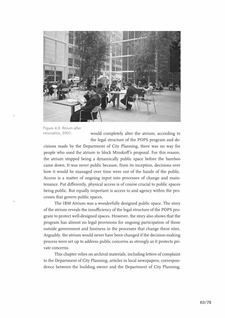
76
BAMBOOZLED?
would completely alter the atrium, according to
the legal structure of the POPS program and de-
cisions made by the Department of City Planning, there was no way for
people who used the atrium to block Minsko¤’s proposal. For this reason,
the atrium stopped being a dynamically public space before the bamboo
came down. It was never public because, from its inception, decisions over
how it would be managed over time were out of the hands of the public.
Access is a matter of ongoing input into processes of change and main-
tenance. Put di¤erently, physical access is of course crucial to public spaces
being public. But equally important is access to and agency within the pro-
cesses that govern public spaces.
The IBM Atrium was a wonderfully designed public space. The story
of the atrium reveals the insuªciency of the legal structure of the POPS pro-
gram to protect well-designed spaces. However, the story also shows that the
program has almost no legal provisions for ongoing participation of those
outside government and business in the processes that change these sites.
Arguably, the atrium would never have been changed if the decision-making
process were set up to address public concerns as strongly as it protects pri-
vate concerns.
This chapter relies on archival materials, including letters of complaint
to the Department of City Planning, articles in local newspapers, correspon-
dence between the building owner and the Department of City Planning,
Figure 4.3. Atrium afterrenovation, 2001.
This content downloaded from 62.156.8.197 on Tue, 08 Jan 2019 16:11:12 UTCAll use subject to https://about.jstor.org/terms
63 / 78
and planning department reports to explore these issues. These documents,
and, interestingly, the process of gaining access to them, show that public
involvement in POPS is institutionally absent. The legal structure governing
the ongoing management of these spaces prevents those people who use the
spaces from knowing about and having a say in physical and programmatic
changes to those spaces.
The Original Contract and the Original Design
Architectural critic Herbert Muschamp said, “With its tall, airy bamboo stalks
set o¤ by walls of charcoal granite, the atrium of the IBM Building . . . resem-
bles a cross between a public park and a corporate lobby.” Muschamp’s
description of the former IBM Atrium as a cross between a park and a lobby
referred to more than the atrium’s appearance. POPS are the material result
of a legal agreement between the city and private building owners. While
the IBM Atrium does not contain all the functions of a corporate lobby (its
switchboard and elevator area are separated from the atrium by a glass wall),
the lobby is attached to the building physically, legally, and economically.
Its hybrid appearance, part corporate and part public, bespeaks the complex
contract that generated its form and function. The contract between IBM
and the city was individually negotiated prior to the building’s construction
and according to standards set out in the Plaza Bonus Zoning Ordinance.
In return for constructing and maintaining the atrium and a plaza in front
of the building,8 IBM was able to build an additional 147,600 square feet of
oªce space.9 The exact value of this bonus is diªcult to determine. A 1982
New York Times article noted that rents in prime locations such as midtown
and the Wnancial district ran between $30 to $40 per square foot, per year.
The square footage in this case could have meant an extra $5,166,000 in
annual rental revenues for IBM.
But a comparison of what is actually called for in the contract between
IBM and the Department of City Planning under the POPS program shows
that to a great degree the success of the initial atrium design had little to do
with legal leverage and everything to do with thoughtful design. This thought-
fulness was not just about the inclusion of the bamboo grove. It also related
to large-scale design decisions about the relationships between the private
spaces of the corporate tower and the public spaces of the atrium.
IBM hired two excellent designers to develop the public spaces. As a
result, the atrium’s conWguration, from the large to the small scale, worked
77
BAMBOOZLED?
This content downloaded from 62.156.8.197 on Tue, 08 Jan 2019 16:11:12 UTCAll use subject to https://about.jstor.org/terms
64 / 78

as a public space in ways that most other POPS developed at the same time
and according to the same standards did not. Muschamp hit on one of these
points when he described it as a park and a lobby, but he didn’t note the ways
the corporate and the public spaces are fairly separate. At the scale of the
entire building, there is a clearer distinction between the private spaces of
the corporate tower and the public spaces of the atrium. The atrium is not
embedded deep within a private building—as is the case, for example, at the
Citicorp Building a few blocks away.
The distinction between the atrium and the oªce tower is clearly dis-
tinguishable by passersby at ground level. The building’s footprint is com-
plicated. It is not a simple slab. It does not Wll its lot. Nor is it pulled back
from the sidewalk evenly. It can be seen as two buildings: an oªce tower
and a greenhouse (Figure 4.4). The two nest against each other as more or
less triangular portions of the same square. Tips of each triangle are cut o¤
to create entrance plazas. What is interesting
about the public spaces, particularly the atrium,Figure 4.4. Exterior of atrium,2001.
This content downloaded from 62.156.8.197 on Tue, 08 Jan 2019 16:11:12 UTCAll use subject to https://about.jstor.org/terms
65 / 78

is the degree to which they stand on their own. The atrium is clearly attached
to the oªce tower, but only along one wall. The southern wall faces onto the
sidewalk of Fifty-sixth Street. The southwestern wall is an interior wall with
a connection to the public spaces of Trump Tower. The northeastern wall is
a clear glass wall with doors through to the lobby of the oªce tower. And the
eastern wall, the shortest of the walls, is glass, and leads out into the public
plaza on Madison Avenue. The roof to the atrium is also glass, reinforcing
the feeling that it is almost its own structure. The IBM Atrium’s tranquility,
at least the auditory tranquility, comes from being physically separated from
the sidewalk and street by glass walls. These transparent walls serve to priv-
ilege the atrium’s proximity and relationship to the outside over and against
its relationship to the indoor lobby on the other side of the atrium (Figure 4.5).
Again, this independence was not a requirement of the contract with
the Department of City Planning. The separation of atrium and oªce tower
at the IBM building is very di¤erent from interior public spaces in adjacent
midtown high rises. For example, Trump Tower completely envelops the
public spaces within the building. Some have argued they are almost in-
distinguishable as public spaces at all. The Sony Atrium, visible from IBM
across Fifty-sixth Street, borders oªce and retail spaces along two of its
four walls—and these are the longest two. The atrium at Citicorp is not only
embedded inside the building but is sunken below street level. Because of
its visual openness to the street and the sky and the clear distinction between
oªce tower and atrium greenhouse, the IBM Atrium has a much stronger
sense of being a freely accessible space.
Zion and Breen consulted William H. Whyte on the design of the
atrium. Whyte was the public-space guru of Manhattan, the author of revi-
sions to the POPS program in 1975, and a relentless activist for more and
better public spaces. His inXuence on the design of the atrium is clear. The
atrium seemed to be the physical manifestation of Whyte’s public space
ideals as published in his The Social Life of Small Urban Spaces. The atrium
is clearly visible to and from the street on the sides bordering East Fifty-
ninth Street and Madison Avenue. Glass walls rise four stories to the atrium
ceiling, which is topped with serrated trusses.10 When it was Wrst constructed,
eleven stands of bamboo divided the atrium into smaller spaces and Wltered
the light as it fell to the granite Xoor. Giant concrete dishes of Xowers were
changed seasonally and added color to the otherwise gray and green space,
which included a food kiosk, at-grade entrances, clear visibility between the
inside and outside, and movable chairs.
79
BAMBOOZLED?
This content downloaded from 62.156.8.197 on Tue, 08 Jan 2019 16:11:12 UTCAll use subject to https://about.jstor.org/terms
66 / 78
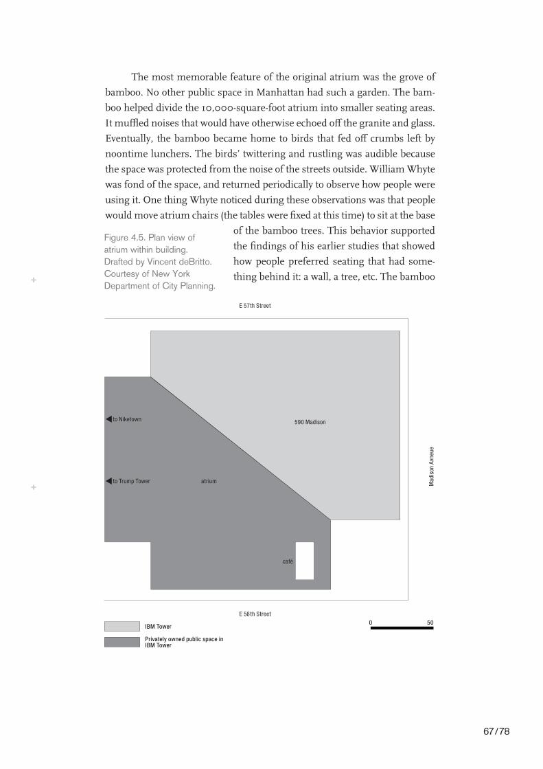
80
BAMBOOZLED?
The most memorable feature of the original atrium was the grove of
bamboo. No other public space in Manhattan had such a garden. The bam-
boo helped divide the 10,000-square-foot atrium into smaller seating areas.
It muºed noises that would have otherwise echoed o¤ the granite and glass.
Eventually, the bamboo became home to birds that fed o¤ crumbs left by
noontime lunchers. The birds’ twittering and rustling was audible because
the space was protected from the noise of the streets outside. William Whyte
was fond of the space, and returned periodically to observe how people were
using it. One thing Whyte noticed during these observations was that people
would move atrium chairs (the tables were Wxed at this time) to sit at the base
of the bamboo trees. This behavior supported
the Wndings of his earlier studies that showed
how people preferred seating that had some-
thing behind it: a wall, a tree, etc. The bamboo
Mad
ison
Avn
eue
590 Madison
E 56th Street
E 57th Street
atrium
café
to Trump Tower
to Niketown
IBM Tower
Privately owned public space in IBM Tower
0 50
Figure 4.5. Plan view ofatrium within building.Drafted by Vincent deBritto.Courtesy of New YorkDepartment of City Planning.
This content downloaded from 62.156.8.197 on Tue, 08 Jan 2019 16:11:12 UTCAll use subject to https://about.jstor.org/terms
67 / 78
grove also served to separate the seating area of the atrium from the walk-
way area. The walkway provided an interior connection between Fifty-sixth
and Fifty-seventh streets. The seating area was visible from the walkway, but
it was clearly a distinct area. It didn’t become apparent exactly how well loved
the atrium and its lush grove of bamboo were until proposals were made by
a new building owner to alter the space’s design.
New Owner, New Agenda
Privately owned public spaces remain public even when a building is sold
to a new owner. New owners are able to change an existing public space as
long as the changes do not come in conXict with the original contract. The
early years of IBM’s ownership of the building coincided with a peak in IBM
revenues. In 1984, earnings were $6.6 billion. Not surprisingly, IBM’s sale
of the building about ten years later to a New York City real estate company
coincided with one of its biggest revenue downturns. During the Wve years
prior to the sale, IBM had cut thousands of jobs, and in 1991 it reported a
net loss of $2.8 billion. Developer Edward Minsko¤, in a joint venture with
Odyssey Partners investment group, purchased 590 Madison Avenue from
IBM in 1994 for $200 million. In 1995, during a dip in the oªce rental
market, Minsko¤ was still able to rent space in the building for about $45
per square foot, per year. The year before, rent had been closer to $50 per
square foot.
When the building changed hands, the atrium was almost exactly as
it had been initially built, despite some reports that IBM had not been main-
taining the space at as high a level as it once had.11 One year after purchas-
ing the building from IBM, Edward Minsko¤ applied to the Department of
City Planning to make alterations to the atrium so that he could install a
rotating exhibition of contemporary sculpture. Minsko¤ would manage the
exhibitions jointly with PaceWildenstein, a commercial art gallery. Minsko¤
proposed removing almost all the bamboo, changing the movable chairs
and tables to benches, and hiring security guards to protect the artwork.
Minsko¤’s application for changes to the atrium set o¤ a controversy that
involved the art community, realtors, designers, and commercial galleries.
Despite the controversy’s high public proWle, it highlighted the fragility of
government-guaranteed public space.
When Minsko¤’s plans were released in early 1995, the eight-month
battle over the future of the atrium began. Not surprisingly, two camps
81
BAMBOOZLED?
This content downloaded from 62.156.8.197 on Tue, 08 Jan 2019 16:11:12 UTCAll use subject to https://about.jstor.org/terms
68 / 78

emerged: those in favor of the sculpture garden and those against destroy-
ing the bamboo grove.12 The Wrst group—let’s call them the pro-art group—
lobbied the Department of City Planning with letters detailing the beneWts
of having works of art in public places. All the letters in the planning-
department Wle that favored the original Minsko¤ proposal were from people
who were in one way or another tied either to nonproWt or for-proWt art
groups. Minsko¤ was himself a noted art collector. In November 1996 at
an auction at Christie’s, Minsko¤ sold for $772,500 a silk-screen painting
by Robert Rauschenberg titled Shortstop. The painting was estimated to be
worth between $800,000 and $1.2million.
The fact that a major real estate developer was also involved in collect-
ing and selling Wne art, and therefore wanted to show it in his building, is
not all that shocking. Nor is the fact that the pro-art letters were from people
in the art business. What is interesting is the way in which Minsko¤ and
the pro-art camp argued that the renovation of the atrium was actually in
the public’s interest. A very short letter from Ivan C. Karp of OK Harris, one
of the oldest commercial art galleries in SoHo, called the existing atrium
“rather stark” and cited the “paucity of public evidence of the vast resources
of Wne art in this city.”13
Diana D. Brooks, then president and chief executive oªcer of Sotheby’s,
wrote: “this project would be a unique opportunity to heighten cultural
awareness through the public display of art work. Additionally, the creation
of a sculpture garden in the IBM Atrium takes on added signiWcance due
to the diminishing federal support of the arts and the lack of funding avail-
able for any project of the same scale. It would be a shame to deny so many
New Yorkers an occasion to enrich their lives through aesthetic apprecia-
tion. The appeal of New York City depends in great part on the richness
and availability of the visual arts to the general public.”14 Brooks’s quote
asserts that the lives of the people who use the space would be uncondition-
ally enriched by the display of art. She implies that there is a dearth of art
on display in New York City. She also implies that the public’s awareness of
culture needs to be heightened. It is hard to accept the recommendations
of the director of Sotheby’s as representative of “so many New Yorkers,” and
I don’t think this was her intention. The assumption embedded in her words
is that, as a cultural leader, the art world needs to provide culture for the
consumption of the masses. She also argued that because the federal gov-
ernment has cut funding for the arts, public space programs should help
take up the slack.
82
BAMBOOZLED?
This content downloaded from 62.156.8.197 on Tue, 08 Jan 2019 16:11:12 UTCAll use subject to https://about.jstor.org/terms
69 / 78
Those against the initial proposal included William Whyte, who was
consulted by the Planning Committee in the course of their review of
Minsko¤’s plan. In the Planning Committee report, Whyte called Minsko¤’s
plan “retrogressive” because of the removal of the bamboo and also because
of the removal of amenities like the food kiosk and the change from mov-
able to Wxed seating. The committee report also stated that the proposed
space was not a sculpture garden but a sculpture gallery. They argued that
the di¤erence between the two was in the gallery’s “total subjugation of
the space’s verdant and inviting qualities”15 in order to make room for large-
scale sculpture.
The Parks Council also argued that none of the bamboo should be
removed. In a letter sent to the City Planning Commission prior to their
Wnal vote on the proposal, the Parks Council argued that “the original spe-
cial permit issued by the City Planning Commission described the space as
an ‘enclosed sky-lit landscaped park.’ In other words, from its inception this
was intended to provide an interior garden respite in midtown . . . the
unusual qualities of the bamboo plants have come to be uniquely identiWed
with the atrium over the years.”16 They suggested that all the bamboo be
retained and that artwork be added to the existing conWguration. They noted
that “keeping all the trees may mean that certain very large sculptures could
not be exhibited, but this seems a small price to pay for holding on to one of
the success stories of the bonus plaza program.”17
A statement from the Municipal Art Society (MAS) on September 14,
1995, came to the same conclusion and added some additional items for
consideration. It noted that during the review process regarding the atrium,
Minsko¤ had argued that the presence of sculpture would increase public
use of the space. MAS argued that while this might be the case, there were
other factors that needed to be addressed. They noted that the atrium was
too hot in the summer because IBM wasn’t running the air conditioning,
that there were no services other than the food kiosk to draw people to the
space, and that the western corridor was temporarily closed because of the
construction of Niketown. “Each of these conditions contributes to a tempo-
rary decline in visitors,” they concluded, “not the design which indeed has
enjoyed many years of success and heavy usage.”18
As a result of the review process, Minsko¤ came back to the Depart-
ment of City Planning with an alternate proposal. The new proposal removed
three of the eleven bamboo stands and retained most of the original mova-
ble seating. The proposal was approved, and the sculpture garden opened
83
BAMBOOZLED?
This content downloaded from 62.156.8.197 on Tue, 08 Jan 2019 16:11:12 UTCAll use subject to https://about.jstor.org/terms
70 / 78

December 14, 1995. Marc Glimcher of PaceWildenstein Gallery remarked
that the sculpture garden was “great public relations in the long-term sense.
Many of these works have been sitting in warehouses, so it’s wonderful that
the public has the chance to enjoy them. It’s also important to stress the
education component here. Educating the public is the very foundation of
the art market.”19 This quotation must have conWrmed the fears of members
of Community Board Five and others who cautioned against allowing a com-
mercial art gallery to use a public atrium to display artwork. In order to try
to prevent PaceWildenstein from beneWting directly from their involvement,
the city made a stipulation that none of the artwork shown in the atrium
could be for sale at the time of exhibition. Also, the city told Minsko¤ that he
had to set up a committee that would decide curatorial matters, and that not
all the exhibitions could be organized by PaceWildenstein or include artists
that PaceWildenstein represented.
Statements from the planning department emphasized that the out-
come of the process of review was, in the end, positive. City Planning Com-
missioner James B. Rose said, “This is a very good thing for the city. . . . Only
three trees came down, and there’s more seating than there was before.”
This sentiment was not, however, widely held. In “Requiem for an Atrium,”
Ken Smith of the Project for Public Spaces said, “The once powerful ambi-
ent e¤ect of the bamboo garden is now gone, as is most of the magic the
space once had. The altered atrium, even with the addition of colorful sculp-
ture, is a pathetic alternative to the original, and a sad loss of public space
in New York City.”20 The bamboo that is left does not give the sense of being
a grove. The seating areas bleed into one another. The sense of being in an
intimate canopied place is lost. The summer sunlight that was once Wltered
now gives the atrium a kind of gray pallor. One has less a feeling of enclosure
and more a feeling of exposure. In short, the most beloved POPS—lauded
by design critics, journalists, the Department of City Planning, public-space
scholars, and the people who used it everyday—was transformed into some-
thing that none of them had asked for and in a way that completely destroyed
its initial qualities. How was this possible?
The destruction of the atrium was possible because of the legal struc-
ture of the POPS program. The review process that allowed Minsko¤ to make
the changes is still in place today. According to the POPS legal structure,
owners may make changes to bonus spaces. There are two basic categories
of changes, each with a di¤erent review process. “Major” changes require
a Uniform Land Use Review Procedure (ULURP).21 The process ends with a
84
BAMBOOZLED?
This content downloaded from 62.156.8.197 on Tue, 08 Jan 2019 16:11:12 UTCAll use subject to https://about.jstor.org/terms
71 / 78

review by the City Planning Commission, and may also involve a review by
the City Council. It does not speciWcally call for a public hearing but does
involve elected oªcials who, theoretically, could be voted out in the next elec-
tion if their constituents disagree with their actions. “Minor” changes need
to be reviewed only by the City Planning Commission. The City Planning
Commission may act in consultation with the local community board,22 but
it is not required by law. Community boards in New York City represent not
only the residents of that community but also the businesses and tourists.
City Planning Commission sta¤ members have conWrmed that the
di¤erence between a major and minor change is not laid out in the zoning
code. Rather, major versus minor is thought to be “intuitive and obvious.”
Those exact words were used in an interview with a planning department sta¤
member. The example the sta¤ member gave was that if the overall square
footage of the space doesn’t change, it is not a major renovation. In cases in
which the di¤erence between major and minor is not intuitive, Department
of City Planning counsel is consulted.23 The controversy over the renovation
at IBM and the Wnal compromise reached between Minsko¤ and the plan-
ning department show how even minor changes can have major e¤ects.
Why does a public program to provide public spaces pay little or no
attention to the idea of public involvement in decision making? First, when
the code was initially written in 1961, it was not to provide new public spaces.
Rather, the initial policy’s sole stated purpose was to bring more light and air
into the city. The policy was altered in 1975, but only to require amenities
like seating, food concessions, and on-grade connections to the street. Sec-
ond, while these alterations to the policy regarding amenities were carefully
spelled out, and indeed spelled out on signs in each space and on the De-
partment of City Planning Web site, there is little or no information in the
current policy regarding who has the ability to dictate or enforce rules for
conduct in the spaces or to conduct or block alterations to the space that fall
outside what is spelled out in the contract. In other words, the bonus pro-
gram as it is legally written and therefore enforced by the Department of
City Planning focuses on providing a speciWc set of physical amenities. The
assumption is that if these amenities are provided, the resulting spaces are
public spaces. The policy does not detail who has the ability to control phys-
ical access to a space or who has access to decision-making processes. As de
facto third parties in the contract, members of the public are legally guaran-
teed, for example, a certain amount of seating, the presence or absence of a
food kiosk, and speciWc opening hours.
85
BAMBOOZLED?
This content downloaded from 62.156.8.197 on Tue, 08 Jan 2019 16:11:12 UTCAll use subject to https://about.jstor.org/terms
72 / 78

However, building owners are not all in compliance regarding the pro-
vision of required amenities. Contract enforcement has proved to be diªcult.
Owners limit opening hours, do not provide the correct amount of seating,
and allow cafés and other private businesses to encroach on atriums and
plazas. The authors of Privately Owned Public Space argue that the main
problem with the program is the lack of enforcement of contracts. Their pre-
scription for better enforcement, seen in light of the IBM controversy, also
indicates a fundamental problem with the entire basis of New York’s pro-
gram: the authors argue that if the public took more of a proprietary interest
in POPS, they would take an interest in helping the Department of City
Planning hold owners to their contracts. The authors assert:
[a]n e¤ective enforcement program consists of Wve elements:
up to date documentation, broad public knowledge, periodic
inspections, meaningful remedies, and promotion of public use. . . .
With quick and easy access to such information—what policy
makers sometimes refer to as transparency—the public can know
what is expected of an owner and serve as supplemental “eyes and
ears” to a more formal inspection protocol.24
The authors go on to argue that the key to members of the public
developing an active proprietary interest is encouraging greater public use of
a space. Referring to the ideas of William H. Whyte, the authors maintain
that “use begets more use” and if a space is of “suªcient quality to make
people want to use it in the Wrst place . . . people will take a proprietary inter-
est and help safeguard its continuing provision according to the applicable
legal mandates.” Further, the role of the city and interested private nonproWt
groups is to “facilitate the use of public space, by describing them, as in this
book, and by adopting a curatorial mentality.” In order to increase public
use, the authors encourage events such as “[r]oving art exhibits and travel-
ing concert series.” Such events would then “enable the public to conceive
of these spaces as part of a larger system o¤ering great value to the life of the
City.”25 They presume that when the public develops this kind of proprietary
interest they will be moved to check up on the provision of amenities and the
opening hours listed on the plaques, and to report any discrepancies to the
Department of City Planning. The authors conclude: “it is up to institutions
of government, the private not-for-proWt world, and the private sector as well
as members of the public, to assure that this physical space is provided in its
most alluring form.”26
86
BAMBOOZLED?
This content downloaded from 62.156.8.197 on Tue, 08 Jan 2019 16:11:12 UTCAll use subject to https://about.jstor.org/terms
73 / 78
But how can the public feel proprietary about a space they do not
collectively own and that is governed by processes to which they have little
or no access? It is quite easy to see why the building owner’s interests are
signiWcantly stronger than those of the public. To Minsko¤, the atrium is
part of his private property. Whether or not Minsko¤ is able to turn a proWt
depends on the perception of the building as formed in the minds of per-
spective clients. The appearance of the public space is directly related to
the image of the building. One could argue that the presence of a rotating
exhibit of works of art presents a more salable image than, for example,
three stands of bamboo and a lot of loiterers. While it may seem a bit of a
stretch to say that Minsko¤’s decision to exhibit art was mercenary because
it would train members of the public to be art lovers and therefore bolster
the price of his own collection, Minsko¤ did recognize that the presence of
art enhances the perceived value of a building. The beneWts to PaceWilden-
stein as the co-organizers of the exhibitions was also indirect but sizable.
While it could not sell any of the artwork that was on display in the atrium,
its corporate proWle and the proWle of its artists were raised through the exhi-
bitions and exhibition press coverage.27
After the Bamboo
The month before the atrium reopened, Minsko¤ violated the provisions of
the special permit by closing the atrium from November 3 to 7, 1995. In a
letter reminding Minsko¤ of his contractual obligations, Nicholas Fish, then
chair of Community Board Five, added that “[s]ince Community Board Five
strongly supported your application to modify the public space, I feel it is my
duty now to express my grave concern.”28 Minskso¤ claimed that the clo-
sures were necessary to the installation of the artwork. He also admitted that
he held a private event in the space during this time. Unauthorized closures
are nothing unusual in the scheme of the POPS program. What is unusual
about the post-renovation conXict over the IBM Atrium is the level of disap-
pointment expressed by those involved in the decision-making process. Even
those people who had a voice in the negotiations over the space expressed
disappointment in the process and its results. Minsko¤ not only violated
opening hours, but also failed to comply with provisions for the manage-
ment of the sculpture display.
For example, part of the agreement was that there would be an advisory
committee that would “help to ensure the broadest possible participation of
87
BAMBOOZLED?
This content downloaded from 62.156.8.197 on Tue, 08 Jan 2019 16:11:12 UTCAll use subject to https://about.jstor.org/terms
74 / 78

major 20th Century sculptors.”29 This was in part to prevent Minsko¤ and
PaceWildenstein from exhibiting only the work of PaceWildenstein clients.
The advisory board was described in a resolution dated March 9, 1995:
An advisory council, with Community Board Five as a member,
will be established to ensure both the broadest possible
participation of major Twentieth Century sculptors in rotating
exhibitions and the inclusion of artists represented by and in a
diverse group of galleries and museums. This council is not
intended to serve in either a controlling curatorial or
bureaucratic manner.30
Between 1995 and 1999, the advisory board met only once, or at least Com-
munity Board Five was involved in only one meeting. In a 1996memo, one
member of the advisory committee who was also a member of Community
Board Five stated that she felt “duped” by Minsko¤ and PaceWildenstein:
I believe that it [the Sculpture Garden at 590Madison Avenue] is
both a disappointment and a sham. You cannot imagine how it
saddens me to say this, as I feel so duped, and like I misled the
Board. The biggest fear, addressed very clearly in the Board’s
resolution, was that the space would be perceived as a commercial
extension of PaceWildenstein Galleries. Not only is this the
perception, but it is, in fact, close to the truth.31
The writer pointed out that the only show to run between June 1996 and No-
vember 1996 was Alexander Calder, who is represented by PaceWildenstein.
She also noted that the opening show was dominated by PaceWildenstein-
represented artists, that a sign for the exhibition had PaceWildenstein’s name
on it, that PaceWildenstein had not returned calls regarding the scheduling
of advisory committee meetings, that in 1996 the advisory committee had
met only once, and, Wnally, that none of the outreach or educational pro-
grams discussed during advisory board meetings had been developed.
Why I was foolish enough to believe that a real estate developer
and a commercial gallery would act in a selXess, altruistic manner
for the people of New York City is beyond me. . . . Unless we
can change the current situation, I would recommend that we
take action against any and all future approvals regarding
PaceWildenstein, as represented by Marc Glimcher, and 590
Madison, as represented by Edward J. Minsko¤.32
88
BAMBOOZLED?
This content downloaded from 62.156.8.197 on Tue, 08 Jan 2019 16:11:12 UTCAll use subject to https://about.jstor.org/terms
75 / 78

This letter indicates that many of the concerns raised in the review pro-
cess regarding conXict of interest between the building owner and the
management of the public space were well-founded. Minsko¤ did use the
sculpture garden as an excuse to close the atrium to the public. Minsko¤
and PaceWildenstein did use the sculpture garden to promote artists that
PaceWildenstein represented. Minsko¤ did disregard aspects of his con-
tract, and responded only after repeated attempts at contact were followed
by threats. Some concerns were raised by Community Board Five, others
by the Municipal Art Society. These groups were part of the review process
only because the Department of City Planning decided to invite them to
review Minsko¤’s proposal. Because the planning department categorized
the renovation of the atrium as a minor modiWcation, they could have come
to a decision with no input from outside reviewers. Only the City Planning
Commission was required to be part of the review.
The problem with categorizing renovations as major or minor when
there is no deWnition to work by is that the decision of what requires review
and what doesn’t can be arbitrarily assigned by the City Planning Com-
mission on a case-by-case basis. All the control over what can and can’t be
changed in a POPS falls in their hands. They may, of course, decide to in-
clude some kind of review process, but they are not required to do so. What
is most shocking about this lack of clear deWnition and the way this can be
used to prevent public input is that it is anything but a bureaucratic over-
sight. While it is diªcult to say that the law was originally intentionally vague
so as to give this latitude to the City Planning Commission, it is possible to
argue that the law is being kept vague for that reason.
Just two years prior to the controversy over the IBM Atrium, a simi-
lar controversy erupted across the street at the AT&T Building. In 1992 the
Sony Corporation took over the former AT&T Building, and proposed to en-
close what was an exterior space as an interior atrium. This change was even
more drastic than the change at the IBM Atrium, and it was considered
minor. Richard Scha¤er, former chair of the City Planning Commission,
received complaints about the commission’s handling of the review process.
Ruth Messinger, former president of the borough of Manhattan, argued
that “the community should not have to depend on an applicant’s goodwill
to obtain meaningful input into a project modiWcation.” She stated, “the ab-
sence of clear criteria establishing thresholds for the distinction between
major and minor modiWcations” is “unacceptable” because it “allows the
City Planning Commission and the Department of City Planning to make
89
BAMBOOZLED?
This content downloaded from 62.156.8.197 on Tue, 08 Jan 2019 16:11:12 UTCAll use subject to https://about.jstor.org/terms
76 / 78
arbitrary determinations which are likely to allow signiWcant changes to
escape appropriate public and administrative review.”33 Michael Presser,
chairman of Community Board Five, raised the same concerns. Community
Board Five unanimously passed a resolution in the summer of 1992 call-
ing for the City Planning Commission to “act promptly to establish Wrm
guidelines and thresholds for review of modiWcations to previously approved
special permits in order to eliminate the appearance of arbitrariness and
favoritism and to guarantee a fair review.”34
In light of these serious concerns that were shared by the borough pres-
ident, the chief elected oªcial of the entire borough of Manhattan, and every
member of Community Board Five, the response from Scha¤er, the chair
of the City Planning Commission, is astonishing. He simply explained the
legal structure surrounding modiWcations to POPS as the structure stands.
He states that modiWcations to POPS are subject to a Uniform Land Use
Review Procedure “unless they require new waivers, authorizations or spe-
cial permits under additional sections of the Zoning Resolution, or propose
additional waivers or authorizations under the same sections but beyond
the scope of those originally granted.” He said that this legal structure works
because it “allow(s) modiWcations to proceed by the most reasonable method
possible, consistent with the nature of the changes requested.” He argued
that “imposing elaborate procedures” would in many cases be “wasteful of
administrative resources.” He further argued that the best approach is for
the City Planning Commission and Department of City Planning to set up
“additional procedures” on a case-by-case basis when proposed changes “in-
volve more than routine details of design or function.”35
The process Scha¤er describes is exactly the process that both Com-
munity Board Five and the borough president criticized as being too open
to arbitrary decisions. Scha¤er did not address the concerns over or even
acknowledge the possibility of such serious problems. Nor did he address
the fact that changes might be made to a POPS that require no new special
permit but that signiWcantly change the quality of that space. Scha¤er’s de-
scription of public processes as “additional procedures” that may be “waste-
ful of administrative resources” indicates a belief that eªcient bureaucracy
is more important than opening the review process to broader scrutiny. His
response also indicates a very particular stance to the legal foundations of
the POPS program. He describes the law as it stands, and does not engage
in a discussion of how it might be changed to reXect the real concerns of
members of the public and their elected representatives.
90
BAMBOOZLED?
This content downloaded from 62.156.8.197 on Tue, 08 Jan 2019 16:11:12 UTCAll use subject to https://about.jstor.org/terms
77 / 78

The controversy over the atrium highlights speciWc issues around the
“publicness” of New York’s POPS not because of who is allowed to use them
or for what purpose, but because of who is allowed to make decisions about
how the spaces are changed over time. The POPS program itself must be
changed to include not only public access to the physical spaces but also
public access to the decision-making processes. Why does the Department
of City Planning seem to see itself more as a mediator between “the public”
and “the building owner” rather than as part of the public itself, advocat-
ing for public interests? This revision of the review process must also ask
whether review by elected oªcials is even suªcient. David McGregor, archi-
tect and former director of planning for Manhattan for the New York City
Planning Commission, argued that “[s]ince these are public spaces, the pub-
lic ought to have a say about them. Then if we don’t like what our elected and
appointed public oªcials do, we can throw the bums out the next time.”36
But should waiting for the next election and casting a vote against someone
you think made a bad decision be the level of possible public involvement
in these processes? Or should the changes to the POPS program include
bureaucratic processes for direct rather than representational involvement?
And do the public oªcials who would be involved in making decisions about
the space really represent the public of that space? Many people who use the
atrium every day are oªce workers taking a break. They most likely live out-
side Manhattan. Others may be visiting New York from other states or coun-
tries. The POPS program went through a major rewriting process in 1975 in
order to increase the requirements of building owners to provide more and
better physical amenities in exchange for the Wnancial incentives they receive.
There is no reason why the program cannot be rewritten again to ensure that
changes to the spaces are open to public and not quasi-public review.
However, even if this important link between POPS and the public
spheres that govern them is mended, there are other fundamental prob-
lems with the program’s policy and the speciWc spaces it has created that also
prevent them from being dynamic public spaces. These problems arise be-
cause of the clash of values brought to these spaces by private developers, the
planning department, and the people who claim them. The next two chap-
ters examine spaces adjacent to IBM: Sony Plaza and Trump Tower. Whereas
at IBM, changes in the plaza’s design revealed underlying problems with
the POPS decision-making processes—problems that preclude these spaces
from having active public spheres—design at Sony and Trump acts upon the
public itself.
91
BAMBOOZLED?
This content downloaded from 62.156.8.197 on Tue, 08 Jan 2019 16:11:12 UTCAll use subject to https://about.jstor.org/terms
78 / 78