MASTER PLAN - Custer City98F72637...uster City Parks MASTER PLAN ... This master plan is the...
100
C uster City Parks MASTER PLAN
Transcript of MASTER PLAN - Custer City98F72637...uster City Parks MASTER PLAN ... This master plan is the...

Custer City P a r k s
MASTER P L A N

• 2 • CITY OF CUSTER PARKS AND RECREATION MASTER PLAN

March 2017
MayorJared Carson
City Council MembersJeannie Fischer, Ward 1
Larry Maciejewski, Ward 1Kris Blom, Ward 2
Nina Nielsen, Ward 2Alfred Heinrich, Ward 3
Karen Schleining, Ward 3
Parks, Recreation & Forestry BoardSteve PinchkeJenny Behlings
Warren GrahamMary Hoover
Patti LeeCarrie MooreJayme Severyn
Rex Jorgensen, YMCA LiaisonTanya Olson, Custer School Board Liaison
Dave Ressler, Chamber of Commerce LiaisonTim Wollaston, Custer City Staff
Prepared by:
City of Custer Parks Master PlanCuster, South Dakota
Prepared For:
City of Custer
Stanley Design Group
Mike Stanley, PLAKortney Geary
Mike Bender, PLABrett GurholtAlex Bossert
Jenna Machado

TABLE OF CONTENTS
|01| EXECUTIVE SUMMARY 8
|02| INTRODUCTION 9
REGIONAL CONTEXT .................................................................. 9Southern Black Hills and Custer County .................................... 10
Southern Black Hills ........................................................................ 10Custer County ............................................................................... 11Custer City Information ................................................................... 11History ........................................................................................ 11Character ..................................................................................... 12
Demographics .................................................................... 13Population Demographic .................................................................. 13Age Demographic ........................................................................... 14Housing and Income Demographic ....................................................... 14
|03| PURPOSE AND METHODOLOGY 15
PURPOSE ............................................................................... 15
METHODOLOGY .......................................................................15Review of Previous Studies ................................................... 15
Inventory of Existing Facilities ............................................... 15
Identifying Needs Through Public Input .................................... 15
Compilation of Findings and Recommendations .......................... 16
PREVIOUS STUDIES & POLICY FRAMEWORK .....................................162031 Plan: City of Custer City Comprehensive Plan ..................... 16
City of Custer Long Term Recreation Committee Strategic Plan, 2004 16
Community Forestry Plan ..................................................... 16
Custer Park and Recreation Board Five Year Plan ........................ 17
|04| EXISTING CONDITIONS AND INVENTORY 18Dedicated and Developed Parks ............................................. 18
Gates Park ................................................................................... 18Community Garden ......................................................................... 22Community Center .......................................................................... 23Way Park ..................................................................................... 27

French Creek Park .......................................................................... 29Harbach Park ................................................................................ 32Big Rock Park ................................................................................ 35Pageant Hill .................................................................................. 40
Dedicated/Undeveloped Parks ............................................... 43Inman Park ................................................................................... 43Unplanned City Property.................................................................. 47
Other Recreation Facilities ................................................... 49City Pool ...................................................................................... 49Custer Schools Football Field & Track ................................................. 50Custer Schools Campus .................................................................... 51YMCA .......................................................................................... 52Custer Skywalk Trail ....................................................................... 53Mickelson Trail & Custer State Park Spur ............................................. 54Dick Estes Fitness Park .................................................................... 56Rocky Knolls Golf Course.................................................................. 57
PARK FACILITY INVENTORY .........................................................58
|05| PUBLIC ENGAGEMENT 59PROGRAM STAKEHOLDERS ..................................................... 59
COMMUNITY STAKEHOLDERS .................................................. 59
PUBLIC MEETING NO. 1 ..............................................................60Station No. 1 - Where I Live|What Parks I Use|What Routes I Take To Get To The Park ................................................................................ 61
Summary ......................................................................... 61
Station No. 2 - Favorite Activities|Activities Needed|Needs To Be Fixed 61Summary Comments From The Individual Parks ..................................... 61
Station No. 2 Summary ........................................................ 63
Station No. 3 - Where New Parks Lands Should Be Developed|Where New Connections Should Be Made ................................................. 63
Summary of Comments for New Public Spaces or Parks ............................ 63Summary Of Comments Regarding New Roads, Bike Paths And Sidewalks ..... 64
ONLINE SURVEY RESULTS ..........................................................64Elementary School Input Sessions ........................................... 65
Summary of comments of favorite activities, activities needed and things that need to be fixed. .......................................................................................... 65
Summary .......................................................................... 67
PUBLIC MEETING NO. 2 ..............................................................68
|06| LEVEL OF SERVICE (LOS) ANALYSIS 69

Park Classification .............................................................. 69Pocket (Mini) Park .......................................................................... 69Neighborhood Park ......................................................................... 70Community Park ............................................................................ 71Special Use ................................................................................... 71Open Space/Natural Area ................................................................. 72
Service Radius ................................................................... 73
Developed Park Acreage and Amenities .................................... 75
Community Comparison ....................................................... 76
SUMMARY .............................................................................. 76
|07| PARK RECOMMENDATIONS & PRIORITIES 77
RANKING CRITERIA ...................................................................77Recreation and User Benefit (Weight = 6) ................................. 77
Health and Safety (Weight = 4) .............................................. 77
Public Input (Weight = 3) ...................................................... 77
Project Cost (Weight = 7) ..................................................... 77
Operation and Maintenance (Weight = 5) .................................. 78
Land Acquisition (Weight = 2) ................................................ 78
Planning Goals and Livability (Weight = 1) ................................ 78
DEVELOPED PARK IMPROVEMENTS ................................................78New Park Development ........................................................ 82
Unplanned City Property.................................................................. 82Inman Park ................................................................................... 82Community Center Park ................................................................... 82French Creek Linear Park ................................................................. 82
Park Development Guidelines ................................................ 84Park Types ................................................................................... 84General Recommendations ............................................................... 85Drainageways and Flood Hazards ...................................................... 88
Parks and Open Space Plan (Figure 71) .................................... 90
Parks and Recreation Connectivity Plan ................................... 91
|08| FINANCES AND IMPLEMENTATION 93Parks and Recreation Budget ................................................. 93
Funding Strategies & Opportunities ......................................... 93Special Improvement District ............................................................ 94Parks Improvement District .............................................................. 94User Fees ..................................................................................... 94

Grants ............................................................................. 94Land & Water Conservation Fund (LWCF) Grants .................................... 94Recreational Trails Program (RTP) Grants ............................................ 95Transportation Alternatives Program (TAP) .......................................... 95National Trails Fund ....................................................................... 95Bush Foundation ............................................................................ 96South Dakota Department Of Health ................................................... 96

|01| EXECUTIVE SUMMARYIn September of 2016, KLJ was contracted to develop a Parks and Recreation Master Plan for the City of Custer City. The parks and recreation planning process began with an assessment of parks and facilities, trails and open space within Custer City. The design team also gathered and reviewed available existing base data for the City of Custer including maps, past studies and plans, individual site master plans and other relevant information. From these findings, KLJ along with Stanley Design Group performed a detailed needs analysis that included ample public and focus group input.
This master plan is the culmination of reviews, analyses, and findings from assessments of Custer City’s existing parks and recreation facilities, a thorough public input process, and invaluable feedback from the community on important values, themes, and priorities.
PURPOSE OF THE PLANThe purpose of the Custer City Parks and Recreation Plan is to inventory existing parks and recreation facilities in Custer City, identify deficiencies in the parks system and prioritize potential projects and present a vision for the development of future parks, open space and recreation activities.
METHODOLOGYThe design team utilized a variety of processes to determine the park and recreation needs of Custer City. The activities include:
1. Review of Previous Studies
2. Inventory of Existing Facilities
3. Identifying Needs Through Public Input
4. Compilation of Findings and Recommendations
5. Additional Public Input
6. Finalization of the Parks and Recreation Master Plan
PLAN PROCESS

LEVEL OF SERVICE (LOS) ANALYSISLevel of Service standards for parks, greenways, and open space have been developed by the National Recreation and Parks Association (NRPA). These standards provide a guide for communities to assess how well they are serving their residents in terms of parks, recreation, and open space opportunities. The NRPA has provided this information for general guidance realizing that each community is different and each has its own unique needs. Community demographics such as age distribution play an important part in determining park amenities and types. For instance, Custer has a larger than average senior population (26.5% greater than age 65) which will have different park requirements than a community with a larger population of school age children or young adults. Using the NRPA standards, as well as case study communities, a narrative can be developed of how well the community is being served in regards to parks and recreation facilities.
PARK CLASSIFICATIONSThe following park classifications were used to define parks within the Custer City parks including Pocket (Mini), Neighborhood, Community, Special Use and Open Space/Natural Area. The radii associated with each park are:
• Pocket Park: ¼ mile radius
• Neighborhood Park: ½ mile radius
• Community Park: 1 mile radius
With this information, the design team was able to identify which types of parks are needed in Custer City and which areas are currently underserved by parks.
LEVEL OF SERVICE CONCLUSIONSOverall, Custer City meets and exceeds NRPA Standards for public open space in terms of acreage per 1,000 resdidents. However, park acreage lacks equitable distribution across Custer City neighborhoods. As the city continues to grow and develop, areas for neighborhood parks need to be identified to provide a more equitable distribution of park land.
RECOMMENDED IMPROVEMENTS & PRIORITIES
PARK DEVELOPMENT GUIDELINESThe intent of parks and recreation classifications is to aid in making acquisition and design decisions for park sites, facilities and the organization of park space which is responsive to public needs, creates quality recreational experiences and facilities that can be effectively maintained.
Park classifications are generally based on National Parks and Recreation Association (NRPA) guidelines and consider variety of uses, size and the area served by each park.
It is not recommended that Custer City develop any additional Pocket (Mini) Parks. Instead, it should focus on developing neighborhood parks in underserved areas of the community and redeveloping existing park land to
improve the quality of park space and increase recreation opportunities.
RANKING CRITERIAThe ranking criteria for recommended park improvements contains seven categories in which each project is scored. The seven categories are Recreation/User Value, Health and Safety, Public Input, Operation and Maintenance, Land Acquisition, and Planning Goals and Livability. Using the ranking criteria, a parks improvement matrix was developed which prioritizes projects based on their overall score.
When performing assessments on the existing parks in Custer City, there were some issues that were
• 10 • CITY OF CUSTER PARKS AND RECREATION MASTER PLAN
identified for most parks. The following are some general recommendations which Custer City should strive to achieve on all parks and recreation properties:
1. Comply with the American with Disabilities Act (ADA).
2. Identify and fill gaps in pedestiran and bicycle connectivity.
3. Provide meaningful bike and pedestrian connections to/from neighborhoods parks and recreation facilities.
4. Preserve existing natural vegetation or provide buffers within stream corridors.
5. Preserve natural drainage areas and utilize for open space connections
6. Provide proper play surfacing and access to play areas in parks.
7. Provide adequate access to shelters, restrooms and other park facilities.
8. Provide a consistent theme for park monument signs that reflects the character of Custer City.
NEW PARK DEVELOPMENT New park development or potential park lands identified during the study phase have been entered in the New Park Land priority matrix shown in Table 14. Descriptions for the projects with scored highly in the priority matrices follow:
1. Unplanned City Property
2. Inman Park
3. Community Center Park
4. French Creek Linear Park
5. Gates Park Master Plan
SUBDIVISON REGULATIONSProvisions exist within the Custer City ordinance which provides set-aside for parks and open space as development occurs. It is recommended that Custer City work with property owners and developers to identify locations for parks which meet the objectives of the parks and open space system and properly serve the new neighborhood developments as they occur.
DRAINAGEWAYS AND FLOOD HAZARDSFrench Creek and Laughing Water Creek and their tributaries provide an important function in the natural ecosystem of Custer City. These drainageways when preserved provide natural stormwater control, preserve natural vegetation, increase biodiversity, and improve overall water quality throughout Custer City. In addition to the ecological benefits, French Creek and Laughing Water Creek can provide recreational benefits for Custer City. Natural drainageways provide opportunities for trail corridors and linear park connections between existing and new parks. It is recommended that these drainagways and their tributaries be properly managed and utilized for stormwater control and greenway connections for the Custer City parks and open space system.

CITY OF CUSTER PARKS AND RECREATION MASTER PLAN • 11 •
|02| INTRODUCTIONThe Custer City Parks and Recreation Plan is a guide for the future development of parks, trails, connections and other recreational facilities within the Custer community. This plan provides the framework for making educated decisions based on existing conditions, community priorities, code compliance and safety considerations. Custer City has embraced an economy based on outdoor recreation, tourism and service. While still tied to other industries such as agriculture and forestry, it is tourism and recreation that provides Custer City with a great opportunity. Retirees and families are attracted to Custer City due to its beautiful environment, small town atmosphere, history and recreational opportunities.
City parks and open space provide several benefits to the city and its residents. Parks, trails and open space promote a healthier population and provide additional economic, social and environmental benefits to the community.
Economic: Research as shown that people are frequently willing to pay more for a house in proximity to parks, open space or trails than a comparable home located farther away from these amenities. This has also been shown to affect commercial properties in the same way. Both factors lead to higher tax revenues. Parks and open space make communities more attractive to live and work in. Quality parks, open space and trails also make communities more attractive to visit and spend time in and this helps generate increased spending in the community.
Social: There are numerous social benefits of quality parks and open space in communities. Residents who have access to open space are more likely to subscribe to a healthier lifestyle and be more physically active. This can lead to a higher quality of life and reduced risk of premature death, diabetes and heart disease. Parks and open space help create a sense of place for a community and increased pride in the community. Children who have good access to parks and natural areas are more connected to nature and have a better understanding of the natural world around them. Participating in activities offered through parks and recreation provide benefits such as relieving symptoms of anxiety and depression.
Environmental: Natural open space, trees, grass and other plantings provide many environmental benefits to a community such as helping air pollution, water pollution, cleansing and controlling stormwater runoff. Providing natural open space increases the natural filtering of water and air through the vegetation and soils preventing many pollutants from contaminating streams and groundwater sources. Natural stream and drainage corridors provide important stormwater control and storage during storm events. Preservation and enhancement of these natural systems is less expensive than engineered solutions such as concrete pipe, concrete lined channels or engineered detention basins.
These factors illustrate the importance of implementing a parks and recreation master plan to promote growth and provide a high quality of living for Custer City. This parks and recreation plan will serve as a planning and development tool for the City to use as it makes improvements to and expands existing parks as well as identifying new areas for parks as the community grows in the future.
REGIONAL CONTEXTCuster City is in the French Creek Valley of the South Central Black Hills of South Dakota. Custer City is a recreation and tourism hub for the region located 40 miles southwest of Rapid City, 30 miles northwest of Hot Springs, and 40 miles east of Newcastle, Wyoming. Custer City is also a short 15-minute (or less) drive to Custer State Park, Crazy Horse Monument, Wind Cave National Park and Jewel Cave National Monument. In addition, Mt. Rushmore National Memorial is a short 25-minute drive from Custer City. The proximity to these destinations makes Custer City an important tourism and recreation hub for the Southern Black Hills.
Custer City is the highest city in South Dakota with an elevation of 5,318 feet above sea level. Custer City’s

• 12 • CITY OF CUSTER PARKS AND RECREATION MASTER PLAN
setting and surrounding environment is incredibly unique. The land forms, rock formations, moderate climate and scenic beauty have drawn people to the region for its entire history. Several highways provide access to and from Custer City including US Highway 16/385 to the north, US Highway 16 to the west, US Highway 16A to the east, and US Highway 385 to the south. SD Highways 36, 87, and 89 provide additional access to and from Custer City. The Mickelson Trail provides an important recreation corridor through Custer City. This 109-mile recreation trail was completed in 1998 and connects Edgemont, SD on the south end to Deadwood, SD on the north end. In addition to the primary trail, the Custer State Park Spur provides trail access from the Mickelson Trail to Custer State Park to the east.
SOUTHERN BLACK HILLS AND CUSTER COUNTY
Southern Black HillsPrior to European Settlement, the Black Hills were inhabited by several Native American tribes including the Gatche Apache, Cheyenne, Kiowa and Lakota. As early as 1861, residents of what is now Eastern South Dakota began organizing groups to explore the Black Hills and confirm reports that gold could be found there. These stories of gold prospects continued to provide interest in the Black Hills even though the area was off limits to white settlement due to the Fort Laramie Treaty of 1868. The citizens of Yankton continued pressure on the government to organize an expedition of the area. In 1874, the Black Hills Expedition (Figure 1) was led by Lieutenant Colonel George Armstrong Custer to explore the area in search of a location for a fort, a round to the southwest, and investigate the validity of gold in the area. The expedition arrived in the Black Hills on July 22, 1874 and set up camp at present day Custer City.
Figure 6: 1874 Black Hills Expedition
Prospectors who accompanied the expedition found traces of gold in the streams and a significant discovers was made on August 1, 1874 in the soil of French Creek. The discovery of gold spread quickly and a gold rush ensued bringing thousands of people to the area. When miners found significant gold near Deadwood, Custer’s population dwindled to almost nothing overnight as the prospectors flocked to the northern Black

CITY OF CUSTER PARKS AND RECREATION MASTER PLAN • 13 •
Hills in search of their fortunes (Figure 2). By 1876 there was an estimated 10,000 people in the Black Hills.
Figure 7: Sign commemorating historic events and locations in Custer.
Custer CountyCuster County has an area of approximately 1,573 square miles in the southern Black Hills. The county was created in 1875 and fully organized in 1877. The county has an estimated population of 8,394 according to the American Community Survey data for 2015. The county has several points of interest within its borders including Black Hills National Forest, Custer State Park, Wind Cave National Monument and Jewel Cave National Monument. Custer City serves as the county seat.
CUSTER CITY INFORMATION
HistoryCuster City was originally laid out in August of 1875 by a group of miners already in the area. Custer City is considered the oldest established town in the Black Hills. The original town was a mile square and divided into lots. The name of the town was decided in a close vote by the veterans of the Civil War. The name of Custer won out over Stonewall since there were more Union veterans than Confederate veterans. Due to the Black Hills Gold Rush that ensued after gold being found during the Black Hills Expedition, Custer grew to an estimated 10,000 residents by 1876. After larger deposits of gold were found near Deadwood, SD, the town depopulated almost overnight as miners and prospectors left for the northern Black Hills. Historical records indicate the population dwindled to 14 people but by the end of 1876 had climbed to 123 people again.
Custer grew steadily due to other industries including the mining of mica and feldspar, forestry and ranching development in the area. In 1890, the Burlington Missouri Railroad developed a connection to Custer City providing additional transit options in the area. The railroad was eventually abandoned and has

• 14 • CITY OF CUSTER PARKS AND RECREATION MASTER PLAN
been redeveloped into the Michelson Trail.
CharacterCuster City is in an incredible scenic area of the southern Black Hill with unique rock outcroppings, forested hills, open meadows, dramatic views and incredible natural beauty (Figure 3). This setting provides a wonderful living environment for Custer City residents and they are very proud of this environment in which they live. Custer City’s setting also provides great visiting experience for tourists to the area and draws people to this area of the Black Hills to experience the history, natural scenery, wildlife, hiking, biking, rock climbing and other tourism opportunities.

CITY OF CUSTER PARKS AND RECREATION MASTER PLAN • 15 •
Figure 8: Overview of Custer City from Big Rock Park
Custer City has evolved into a great mountain town that still maintains its roots in western ranching, agriculture, and forestry. It provides a good blend of agricultural, natural and built environments while preserving a friendly, small town atmosphere. The downtown core contains some great examples of historic architecture which ties Custer City to its important past. New buildings have blended well into this historic environment while maintaining their own character (Figure 4).
Figure 9: Images of Downtown Custer City character
DEMOGRAPHICS
Population DemographicCuster City’s population has had fairly consistent growth over the past 40 years rising from approximately 1,600 residents in 1970 to approximately 2,000 residents today. Custer County has achieved a larger growth rate that Custer City and has an approximate population of 8,446 residents in the county. This could be due to a number of factors including the desire to live in a more rural setting or the lack of available land for housing in Custer City. Table 1 outlines the historical population data for Custer City and Custer County.
Table 1: Historic Population
Year Custer City % Growth Custer County % Growth
1970 1,597 - 4,698 -
1980 1,830 14.59% 6,000 27.71%
1990 1,741 -4.86% 6,179 2.98%
2000 1,860 6.84% 7,275 17.74%
2010 1,987 6.83% 8,296 14.03%
2015* 1,952 -1.76% 8,446 1.80%
*Estimated Source: U.S. Census Bureau
Because Custer City is located near many important Black Hills destinations, it is frequently visited by tourists and day-trippers from surrounding areas. In addition to tourists, the county population also relies on Custer City for its services. This causes city services including parks to serve a larger number of users that would be typical of a town its size. With non-residents serving as important factor to Custer City’s

• 16 • CITY OF CUSTER PARKS AND RECREATION MASTER PLAN
economy, it is important to consider tourism impact when assessing the demand on the Custer City Parks system.
Age DemographicThe 2010 American Census shows Custer City to have a larger aging population than the South Dakota or national average. The largest percentage of the population falls in the range of 45-64 years with 29.6% of the population. The median age of Custer City is 48.6 years, which is 11.8 years higher than the median age of the Unites States of 36.8 (See Table 2).
Table 2: Residents’ Age Distribution
Age Custer City South Dakota United Sates
<25 26.3% 34.9% 34.0%
25-44 25.0% 27.9% 30.3%
45-64 29.6% 26.4% 26.4%
>64 22.9% 14.3% 13.0%
2010 U.S. Census Bureau
Housing and Income DemographicAccording to the 2011-2015 American Community Survey (ACS), the median household income (MHI) income for Custer City is approximately $41,500, which is lower than the state average MHI of $50,957. It should be noted that Census data does not account for second homes and only considers year-round residents of Custer City.
According to the ACS, Custer City has approximately 1,072 housing units as of 2015. The average household size has decreased 33% over the last 50 years, from an average of 3.06 persons per household in 1960, to an average of 2.06 persons per household in 2010. This information is taken from the 2031 Plan: The City of Custer City Comprehensive Plan. In the past few years, there have been several housing units constructed on the east side of Custer City, especially near the newly construction Custer Schools campus. If this development continues, the City should continue to see positive growth through next several years.

CITY OF CUSTER PARKS AND RECREATION MASTER PLAN • 17 •
|03| PURPOSE AND METHODOLOGY
PURPOSEThe purpose of the Custer City Parks and Recreation Plan is to inventory existing parks and recreation facilities in Custer City, identify deficiencies in the parks system and prioritize potential projects and present a vision for the development of future parks, open space and recreation activities. This parks master plan is intended to serve as a working document to guide the Parks and Recreation Advisory Board, elected public officials and city staff in making decisions about budgeting, park facility upgrades, new parks and trails development, partnerships, land acquisition and overall community planning. In response to a needs assessment and public input, the plan prioritized improvements and services to meet community needs.
This plan expands upon several other plans already in place such as the Custer City Comprehensive Plan, Community Forestry Plan and the Parks and Recreation Board Five Year Plan, to name a few. The Parks and Recreation Master Plan also coordinated with individual site plans already developed for several of the parks sites including Gates Park, community center and Inman Park.
This document is intended to be flexible, and presents findings and recommendations that should be evaluated, and/or modified every 5 to 10 years as the City responds to unforeseen opportunities and constraints as well as changes in residents’ needs and demands in the context of other City priorities.
METHODOLOGYWhen developing this parks and recreation plan, the design team utilized a variety of processes to determine the park and recreation needs of Custer City. The activities included but are not limited to:
REVIEW OF PREVIOUS STUDIESThe design team gathered and reviewed several past plans and documents relating to Custer City parks and recreation operations. These plans provided excellent background information to make informed decisions and recommendations about Custer City parks which blend well with previous studies, site master plans and adopted policies.
INVENTORY OF EXISTING FACILITIESEarly in the process, the design team performed individual site visits to each park and shared-use (i.e. Custer Schools) property to assess their condition, amenities, current maintenance and overall functionality of the developed parks. Undeveloped parks and other city land were also inventoried to plan for future development.
IDENTIFYING NEEDS THROUGH PUBLIC INPUTTo identify and prioritize needs of the current parks system, the public was engaged in a participatory workshop early in the design process. A separate workshop was held at Custer Elementary School to engage school age children in the planning process. Idea boards were also placed in the library of the Custer Middle/High School for kids to provide suggestions for the future of Custer City parks and recreation. A small focus group meeting was held which invited youth sports organizations, local clubs, service and non-profit organizations and government agencies. In addition, an online survey was developed to gather additional input.

• 18 • CITY OF CUSTER PARKS AND RECREATION MASTER PLAN
COMPILATION OF FINDINGS AND RECOMMENDATIONSUpon completing the inventory and study phase of the project, the design team compiled the results and analyzed them according to seven categories: Recreation/User Value, Health and Safety, Public Input, Project Cost, Operation and Maintenance, Land Acquisition, and Planning Goals/Livability. Recommendations and guidelines were then presented according to analysis of the conducted review and rating system.
PREVIOUS STUDIES & POLICY FRAMEWORK
2031 PLAN: CITY OF CUSTER CITY COMPREHENSIVE PLANThe Custer City Comprehensive Plan was adopted in 2013 to guide the future growth and development of the city. There are several elements which relate to parks and recreation contained within the Comprehensive Plan. The following items have been identified as relating to parks and recreation development and should be considered when fulfilling this Parks and Recreation Master Plan:
1. Purpose – “Enhance the features that contribute to the quality of life within the community, such as parks and recreation areas, preservation of historic resources, conservation of natural resources, and quality public safety services…”
2. Strategy 2.2.1 – “Develop a long-range park and recreation plan that identifies the needs and opportunities that must be addressed in the community.”
3. 5-5 Stormwater – “The most important components of the city’s storm drainage system are French Creek, Laughing Water Creek and their tributaries… Similarly, smaller natural drainage channels extending into developed areas should be maintained as an alternative to structural improvements. Use of this technique will normally provide both recreational benefits and environmental benefits.”
4. Transportation System Policy – “Provide for a multi-modal transportation system that is inclusive of automobile, pedestrian, bicycle and public transportation.”
5. Pedestrian and Bicycle Facility Policies
a. “Create a safe, convenient and attractive bicycling and walking environment.”
b. “Develop a comprehensive pedestrian or bicycle facilities network among residential neighborhoods, workplaces, downtown, schools, the library, recreation centers, parks and other destinations.”
c. “Continue to promote and expand regional pedestrian or bicycle facilities.”
6. Natural, Cultural, and Scenic Resources – “…work with the County and Forest Service to develop a strategic plan for the protection and improvement of water quality in the French Creek Basin.”
CITY OF CUSTER LONG TERM RECREATION COMMITTEE STRATEGIC PLAN, 2004In 2004, the Long-Term Recreation Committee was charged with reviewing and identifying recreation needs within Custer City and developing a strategic plan to address those needs. The plan developed a recreational vison for the community and set several short and long term objectives to improve recreation opportunities for Custer City residents. The Parks and Recreation Master Plan should coordinate with these objectives and support them. Some of the related items include:
1. Vision – Custer area year-round recreation be available to all, regardless of age, ability or economic status, and that it be fun, safe, dynamic and of the highest standard of excellence.
2. Objective – Develop a community center in partnership with area governmental and not-for-profit entities that would enhance year-round recreation.
3. Also discussed during several interviews in the process, was the need to improve and properly

CITY OF CUSTER PARKS AND RECREATION MASTER PLAN • 19 •
maintain the existing parks and recreation facilities.
COMMUNITY FORESTRY PLANThe Community Forestry Plan was originally adopted in February of 2012 and revised in June of 2014. The purpose of the plan is to provide information, guidance and objectives for managing Custer City’s public green spaces and serves as the comprehensive tree plan for the city. The plan contains several goals, practices and recommendations which closely relate to the Parks and Recreation Master Plan. Some of them include:
1. “Planting a diverse mix of locally adapted shade and fruit trees in city parks and public spaces.”
2. “Retain current park and street trees through proper maintenance, thinning overcrowded trees, and replacement where needed.”
3. The plan also contains specific recommendations for each city park and public space.
CUSTER PARK AND RECREATION BOARD FIVE YEAR PLANThe Custer City Park and Recreation Board prepared a five-year plan which outlined various parks improvements from 2013-2017. Most of the items on the plan relate to maintenance of existing parks, improvements/amenities to the Mickelson Trail linear park system, providing matching funds for various grants and supporting summer entertainment in downtown Custer.

• 20 • CITY OF CUSTER PARKS AND RECREATION MASTER PLAN
|04| EXISTING CONDITIONS AND INVENTORY
DEDICATED AND DEVELOPED PARKS
Gates Park
Figure 10: Gates Park Existing Conditions Map
Gates Park (West End Dam, Figure 5) is approximately 12 acres and is located on the west end of Custer City along Highway 16. The park contains a softball diamond, bleachers, concessions/storage building, playground, restroom, picnic shelters, picnic tables, benches, ADA accessible fishing pier, and gravel parking area (Figure 6, Figure 7, Figure 8). Gates Park is classified as a community park and provides an important parks and recreation anchor on the west side of Custer City (Table 3).

CITY OF CUSTER PARKS AND RECREATION MASTER PLAN • 21 •
Table 3: Gates Park Existing Conditions
Amenity Number Condition Notes
Picnic Tables 2 Good
Bench 2 Good Vinyl coated steel
Grill 1 Good
Shelter(s) 2 Good Wooden with steel roof
Restroom 1 Good Vault toilet, not ADA accessible
Playground 1 Good 2,600 SF play zone, composite structure
ADA Accessibility NA Poor ADA access needed to restroom, playgrounds, shelter, seating areas
Parking Areas 1 Fair Potholes and drainage issues, gravel
Lighting Good Wooden poles
Baseball/Softball 1 Good Fencing needs some minor maintenance
Bleacher Seating 2 Good Aluminum 5-row
Storage Shed 1 Good Concrete block with steel roof
Currently, there is no water in the fishing pond but a Master Plan has been developed to restore the pond. This master plan was completed by Design Works, Inc. (Figure 9) to further develop the park and provide additional amenities such as playground, picnic areas, bike path, an area for ice skating, ADA fishing piers, organized parking area and additional tree plantings. The designed master plan for Gates Park also addresses some of the issues related to ADA accessibility for parking, restrooms and playground access.
Figure 11: Gates Park

• 22 • CITY OF CUSTER PARKS AND RECREATION MASTER PLAN
Figure 12: Gates Park
Figure 13: Gates Park

CITY OF CUSTER PARKS AND RECREATION MASTER PLAN • 23 •
Figure 14: Design Works Master Plan for Gates Park

• 24 • CITY OF CUSTER PARKS AND RECREATION MASTER PLAN
Community GardenThe Custer Community Garden site (Figure 10) is located in Gates Park on Wazi Lane just east of the West End Dam as shown in Figure 5 on page 20. The site consists of approximately 40 garden plots, each measuring 20’ by 20’ square. Grassed walkways approximately 4-foot wide provide access between plots. The site is surrounded by a 6-foot welded wire galvanized fence. Parking is facilitated with a gravel area adjacent Wazi Lane.
Figure 15: Community Garden

CITY OF CUSTER PARKS AND RECREATION MASTER PLAN • 25 •
Community Center
Figure 16: Community Center Existing Conditions Map
The Community Center (Figure 11) site is located at the intersection Crook Street and North 4th Street. The site is the previous Custer Elementary School and has been identified as the new location for a community center and Custer City administration offices. The site has an area of approximately 4 acres including building and parking areas. The site has several remaining play elements from the previous elementary school including play structures, swings, grassed field and hard surface play area (Figure 12, Figure 13, Figure 14, Table 4).

• 26 • CITY OF CUSTER PARKS AND RECREATION MASTER PLAN
Figure 17: Community Center
Figure 18: Community Center

CITY OF CUSTER PARKS AND RECREATION MASTER PLAN • 27 •
Figure 19: Community Center
Table 4: Community Center Existing Conditions
Amenity Number Condition Notes
Playgrounds 3 Fair Wooden play structure in poor condition
Swings 3 Fair Two smaller swing sets are in poor condition
Basketball 1 Poor Surface and goals needs to be replaced
Grassed Play Field 1 Poor Turf in poor condition, not irrigated
ADA Accessibility NA Poor None of the play areas are ADA accessible
Parking Areas 1 Good
Lighting 1 Poor May need additional site lighting for safety

• 28 • CITY OF CUSTER PARKS AND RECREATION MASTER PLAN
A master plan for the Custer City Community Center was completed by Fennell Design and Tallgrass Landscape Architecture in 2012 (Figure 15). This plan was a community-based effort to develop ideas for rehabilitating the existing building to be used as a community center, recreation programs and city office space. The site was designed to provide new outdoor recreation elements including community playground, basketball courts, walking/exercise circuit, winter sledding hill and the potential for a future swimming pool. It is intended that the YMCA will occupy the building and move most its functions from the current location.
Figure 20: Custer City Community Center Site Master Plan

CITY OF CUSTER PARKS AND RECREATION MASTER PLAN • 29 •
Way Park
Figure 21: Way Park Existing Conditions Map
Way park (Figure 16 & Figure 17) is small park with 0.62 acres and contains the Dr. Flick Cabin which is the oldest known structure still in existence in the Black Hills. The cabin along with the land for Way Park was donated by Dr. Daniel Flick who lived in the cabin from 1876 until the early 1900’s. Way Park also has a memorial dedicated to Horace N. Ross who while with Custer’s Black Hills Expedition discovered gold in 1874. The Park currently is a central activity hub for downtown Custer City during the year hosting many community activities such as festivals, farmers’ market, holiday tree lighting and many other community events. The park contains a central gathering plaza, the historic Dr. Flick Cabin, Ross Memorial, public restrooms, picnic tables, benches, drinking fountain and water-wise landscaping.

• 30 • CITY OF CUSTER PARKS AND RECREATION MASTER PLAN
Figure 22: Way Park
Table 5: Way Park Existing Conditions
Amenity Number Condition Notes
Interpretive Cabin 1 Good
Picnic Tables 3 Good One ADA accessible table
Drinking Fountain Good
Restrooms 1 Good Full city services
ADA Accessibility NA Good Park is ADA accessible
Flagpole 1 Good
Lighting 1 Good Flagpole lighting
CITY OF CUSTER PARKS AND RECREATION MASTER PLAN • 31 •
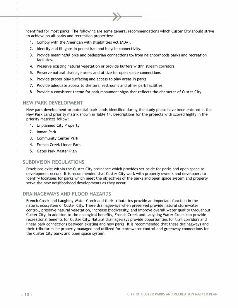
French Creek Park
Figure 23: French Creek Park Existing Conditions Map
French Creek Park (Figure 18) 1.5-acre park developed by ranchers and farmers in the 1950’s to provide them a place to have picnics when they were visiting Custer City. French creek runs through the park creating a very nice creek side environment. The park contains (see Table 6) two playground areas, three picnic shelters, grills, picnic tables, water fountain, restroom and two parking areas. The park has a small bridge on the north side of the park connecting it to the Mickelson Trail. A small horse corral is also adjacent to the Mickelson Trail at this location. The site is slopes at a moderate rate from the south toward French Creek along the north edge of the site. There are several mature trees along Gordon Street and smaller trees planting around the site (see Figure 19, Figure 20 & Figure 21).

• 32 • CITY OF CUSTER PARKS AND RECREATION MASTER PLAN
Figure 24: French Creek Park
Figure 25: French Creek Park

CITY OF CUSTER PARKS AND RECREATION MASTER PLAN • 33 •
Figure 26: French Creek Park
Table 6: French Creek Park Amenities
Amenity Number Condition Notes
Picnic Shelters 3 Good Review for ADA accessibility
Picnic Tables 6 Good
Grills 3 Good
Playground 2 Fair Non-compliant surfacing & safe zone; Metal slide does not comply with current standards
Drinking Fountain 1 Good
Restrooms 1 Good Vault toilet, not ADA accessible
ADA Accessibility NA Poor ADA access needed to restroom, playgrounds, shelter
Parking Areas 2 Fair Gravel surfacing
Bridge 1 Poor Leaning, settling around abutments
• 34 • CITY OF CUSTER PARKS AND RECREATION MASTER PLAN
Harbach Park
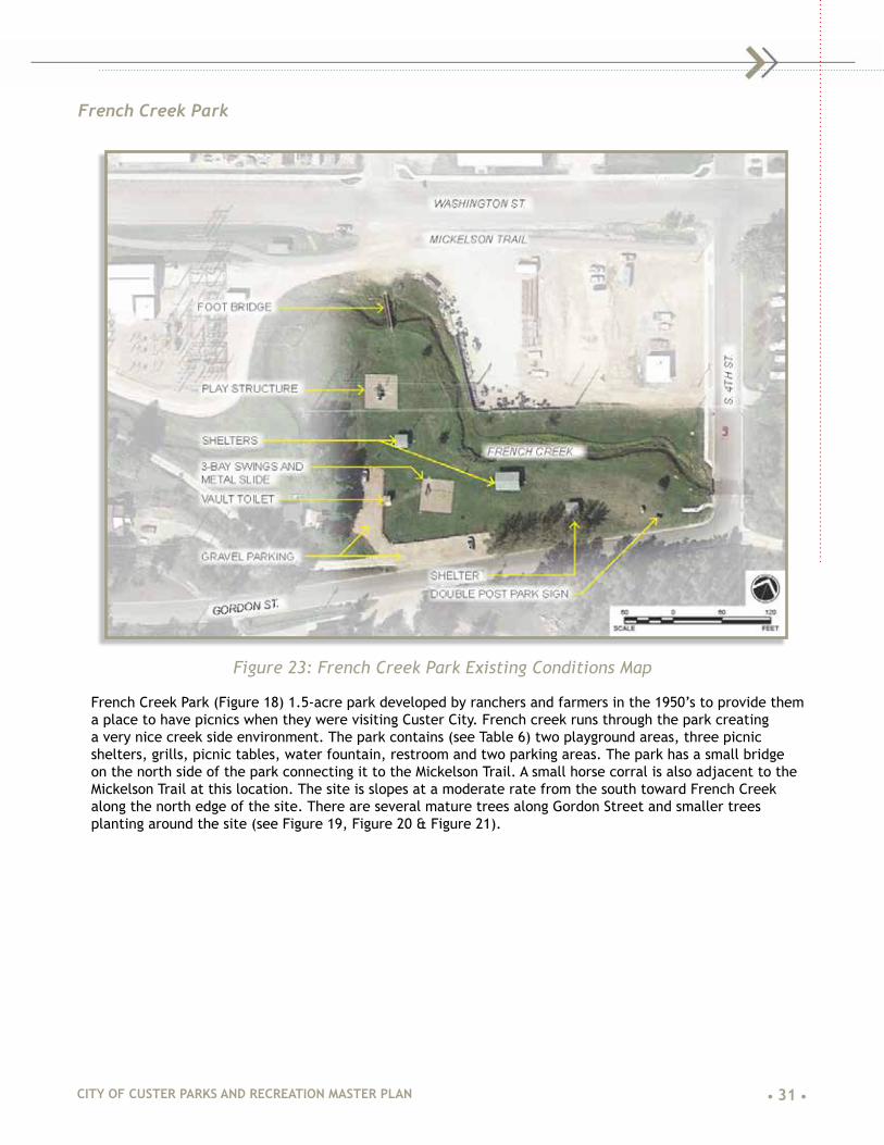
Figure 27: Harbach Park Existing Conditions Map
For the purpose this master plan, when discussing Harbach Park this includes the sand volleyball courts, and the multi-purpose court area east of 7th Street (Figure 22). Although developed at different times, the parks amenities together create a central recreation activity zone south of the downtown Custer City (Table 7). The park is approximately 4-acres in size and contains a playground, three shelters, sand volleyball court, tennis courts, basketball court, skate park, restrooms, horseshoe courts, drinking fountain and parking areas. French Creek runs through the south edge of the park and has a small pedestrian bridge to cross the creek in the middle of the park. Harbach Park serves as a gathering place for various community events and regional events such as the annual Mickelson Trail Trek (Figure 23, Figure 24).

CITY OF CUSTER PARKS AND RECREATION MASTER PLAN • 35 •
Figure 28: Harbach Park
Figure 29: Harbach Park

• 36 • CITY OF CUSTER PARKS AND RECREATION MASTER PLAN
Figure 30: Harbach Park
Table 7: Harbach Park Amenities
Amenity Number Condition Notes
Picnic Tables 6 Good One ADA accessible table
Grills 2 Good
Playground 1 Fair Non-compliant surfacing; Metal standing spinner does not comply with current standards
Drinking Fountain 1 Fair Not ADA accessible
Restrooms 1 Good Full city services
ADA Accessibility NA Fair Some sidewalks are present but not all elements are accessible
Parking Areas 3 Fair 1 paved (Washington St.), 2 gravel surfaced
Bridge 1 Fair Needs maintenance, not ADA compliant
Volleyball Courts 3 Good Sand volleyball courts
Horseshoe Courts 6 Good
Tennis Courts 2 Poor Surfacing in poor condition (cracks & ponding), nets need replaced, fencing needs maintenance
Basketball Court 1 Fair Surfacing in poor condition, restriping needed, goals in good condition

CITY OF CUSTER PARKS AND RECREATION MASTER PLAN • 37 •
Big Rock Park
Figure 31: Big Rock Park Existing Conditions Map
Big Rock Park provides an incredible connection to nature in the middle of Custer City (Figure 26, Table 8). This 73-acre park (including Pageant Hill area) provides a network of hiking trails leading to incredible views of Custer City and the surrounding Black Hills. The undeveloped land on which Big Rock Park sits was part of the original township and was purchased and donated to Custer City for use as a park for its residents. The park is accessed by primarily two areas, the Custer Skywalk Trail which begins at 6th Street near Harbach Park and from Big Rock Trail along Canal Street near Pageant Hill. Trails lead to two incredible overlook platforms one on the southern edge that looks toward downtown Custer City and Black Elk Peak (formerly known as Harney Peak) and the other at the top of Big Rock which affords 360-degree views to the surrounding Black Hills.

• 38 • CITY OF CUSTER PARKS AND RECREATION MASTER PLAN
Figure 32: Custer Skywalk Overlook
Figure 33: Big Rock Park

CITY OF CUSTER PARKS AND RECREATION MASTER PLAN • 39 •
Figure 34: Images of Big Rock Park
Figure 35: Big Rock Park

• 40 • CITY OF CUSTER PARKS AND RECREATION MASTER PLAN
Figure 36: Big Rock Park

CITY OF CUSTER PARKS AND RECREATION MASTER PLAN • 41 •
Figure 37: Big Rock Park
Table 8: Big Rock Park Amenities
Amenity Number Condition Notes
Shelter 1 Good Shelter at overlook
Overlook Platform 1 Good Steps on path up to Big Rock Overlook need to be reset and trail maintained
Picnic Tables 1 Good
Hiking Trails 1 Fair Erosion in several areas, steps need to be maintained/reset, culverts silted in, drainage needs to be improved
Benches 6 Good Consider adding benches along the trail
ADA Accessibility NA Fair Consider providing ADA access to portions of the trail
Parking Areas 3 Fair 1 paved (Washington St.), 2 gravel surfaced
Disc Golf Course 1 Good Maintain vegetation around tees, consider changing walking routes periodically to preserve vegetation
Restroom 1 Fair Portable Restroom. Consider adding permanent restroom with ADA accessibility

• 42 • CITY OF CUSTER PARKS AND RECREATION MASTER PLAN
Pageant Hill
Figure 38: Pageant Hill Existing Conditions Map
Pageant Hill is approximately 15 acres in size has a long history for Custer City(Figure 33). It was the site for over 75 years of the Gold Discovery Days Pageant which operated from 1923 to 2000. Currently, the site provides a large venue space for various festivals throughout the year such as Burning Beetle, balloon rally, community fireworks display, and the Southern Hills Music Festival. The site slopes moderately from west to east and sits on the edge of the natural pine forest of Big Rock Park. A small gravel parking lot provides access to Pageant Hill from Canal Street at the north end of the property.
There are several historic stone structures around the perimeter of the site and the remains of a stone performance area at the west end of the property. The stone performance stage was used during the Pageant for displaying a human American flag. Since that time, a lean-to shelter was built on the back side of it providing a small shade and gathering space. The disc golf course begins in Pageant Hill and traverses up the hill into Big Rock Park. An interpretive map greets visitors at the parking lot and describes the history of Pageant Hill and Big Rock Park and serves as a map of both parks. Portable restrooms are provided at the west side of the park near the shelter (Figure 34, Figure 35, Figure 36, Table 9).

CITY OF CUSTER PARKS AND RECREATION MASTER PLAN • 43 •
Figure 39: Pageant Hill
Figure 40: Pageant Hill

• 44 • CITY OF CUSTER PARKS AND RECREATION MASTER PLAN
Figure 41: Pageant Hill
Table 9: Pageant Hill Amenities
Amenity Number Condition Notes
Shelter 1 Fair Concrete pad needs to be replaced, not accessible
Restrooms 1 Fair Portable, not ADA accessible
Trails 1 Poor Grassed trail, formal connection from parking lot to Big Rock Trail needed
Interpretive Sign 1 Good New sign provides history and orientation
ADA Accessibility NA Poor No ADA accommodations exist
Parking Areas 1 Fair Gravel surfacing
Disc Golf Course 1 Good Maintain vegetation around tees, consider changing walking routes periodically to preserve vegetation

CITY OF CUSTER PARKS AND RECREATION MASTER PLAN • 45 •
DEDICATED/UNDEVELOPED PARKS
Inman Park
Figure 42: Inman Park Existing Conditions Plan
This park (Figure 37, Figure 41, Figure 42) is an undeveloped property north of Lincoln Street and east of N. 8th Street. The park lies in the Laughing Water Creek floodplain and consists of open wetland meadow vegetation. The Mickelson Trail which travels along the east boundary of the property is approximately 20 feet higher in elevation than the site. Previously, park three conceptual plans (Figure 38, Figure 39, Figure 40) were developed by Tallgrass Landscape Architecture to illustrate the potential park development for the site.

• 46 • CITY OF CUSTER PARKS AND RECREATION MASTER PLAN
BMX MEADOW
NATURAL PLAYGROUND
INMAN PARK
CUSTER, SDWATER FOCUSED PARK
FISHING DOCK
POND WITH SAND BEACH
ROADSIDE PICNIC AREA
PARKING - 6 SPACES TOTAL
CREEK CROSSINGS
PARK SHELTER WITH PICNIC TABLES
MICKELSON TRAIL CONNECTION
1/4 MILE TRAIL LOOP
MAY 2014
Figure 43: Inman Park Concept 1, prepared by Tallgrass Landscape Architecture
BMX MEADOW
RESTROOM BUILDING
INMAN PARK
CUSTER, SDneighborhood PARK
PARKING - 4 SPACES
CREEK CROSSINGS
PARK SHELTER WITH PICNIC TABLES
MICKELSON TRAIL CONNECTION
TRADITIONAL PLAYGROUND
ADA PARKING
MAY 2014
Figure 44: Inman Park Concept 2, prepared by Tallgrass Landscape Architecture

CITY OF CUSTER PARKS AND RECREATION MASTER PLAN • 47 •
RESTROOM BUILDING
MICKELSON TRAIL CONNECTION
PLAYGROUND
RESTROOM BUILDING
INMAN PARK
CUSTER, SDfrog pond PARK
PARKING - 5 SPACES + 1 ADA SPACE
CREEK CROSSINGS
PARK SHELTER WITH PICNIC TABLES
MICKELSON TRAIL CONNECTION
SLOPE SWINGS
FROG PONDS ALONG CREEK
PLAYING LAWNS WITH NATURAL AREAS
MAY 2014MAY 2014MAY 2014
Figure 45: Inman Park Concept 3, prepared by Tallgrass Landscape Architecture
Figure 46: Inman Park

• 48 • CITY OF CUSTER PARKS AND RECREATION MASTER PLAN
Figure 47: Inman Park Site

CITY OF CUSTER PARKS AND RECREATION MASTER PLAN • 49 •
Unplanned City Property
Figure 48: Existing Conditions Plan
This undeveloped 3.25-acre City-owned property (Figure 43, Figure 44, Figure 45) is located at the intersection Gordon Street and S. 11th Street. French Creek travels through the south half of the site from west to east. Along the north edge of the site, the Custer State Park Spur recreational trail connects the Mickelson Trail with Custer State Park. The site is a relatively level open grassed field. Originally, the property was identified as a potential location for soccer fields. The turf mowed on a regular basis and is in fair condition with some bare exposed areas. In 2016, the City of Custer applied for and was successful in receiving funding for a Transportation Alternatives Program grant to provide a shared use path connection from the Custer State Park Spur Trail to the Custer Schools Campus. When completed, this shared use path will run along the west and south edges of the site.

• 50 • CITY OF CUSTER PARKS AND RECREATION MASTER PLAN
Figure 49: Unplanned City Property
Figure 50: Unplanned City Property

CITY OF CUSTER PARKS AND RECREATION MASTER PLAN • 51 •
OTHER RECREATION FACILITIES
City PoolThe City Pool located at the northwest corner of North 3rd Street and Crook Street provides Custer City’s only swimming recreation opportunity (Figure 46, Figure 47). The pool was recently repaired with a new liner to eliminate leaks from an aging pool. The new liner is expected to last between 15-20 years. The pool is a basic rectangular pool with no additional water play, slides or splash pad features. A combination bathhouse and concession area building is located on the east side of the site. The only shade on the site is located under the roof adjacent the concession area. Parking is located along the east side and south sides of the property. Parking surfacing is gravel. An ADA accessible ramp provides access from the 3rd Street sidewalk to the building. However, a handrail is needed on both sides of the ramp.
Figure 51: City Pool
Figure 52: City Pool

• 52 • CITY OF CUSTER PARKS AND RECREATION MASTER PLAN
Custer Schools Football Field & TrackThe Custer Schools football field and track provides an important recreation opportunity for Custer City residents (Figure 48). The track is currently used by many people for walking. The all-weather surface provides a great walking surface in all seasons. On-site parking is provided it is adjacent to the Mickelson Trail for easy access. A sidewalk connection along N. 10th Street might could provide better connectivity to the site from the Custer Regional Hospital site and Wedgewood Regional Senior Care assisted living facility.
Figure 53: Track & Field

CITY OF CUSTER PARKS AND RECREATION MASTER PLAN • 53 •
Custer Schools CampusThe Custer Schools Campus has two playgrounds, basketball courts, football field, three soccer fields of various sizes, softball diamond, and baseball diamond (Figure 49, Figure 50). While not an official city park, the school campus serves as a neighborhood park for the southeast area of Custer City. The school system and Custer City have a shared use agreement for the site. Recently Custer City was notified that it was successful in securing a Transportation Alternatives Grant to develop a shared-use path connection from the Custer Park Spur Trail to the Custer Schools Campus. This will provide a safe route for students to use to travel to and from the schools.
Figure 54: Custer Schools
Figure 55: Custer Schools

• 54 • CITY OF CUSTER PARKS AND RECREATION MASTER PLAN
YMCAThe Custer YMCA is located at 644 Crook Street in the historic log community building (Figure 51, Figure 52). The building houses a gymnasium, workout spaces, locker rooms and offices. The YMCA organizes and manages many of the youth sports activities for the community. They also manage the City Pool during the summer. A YMCA managed daycare is located just west of the Custer School Campus and an after-school program is run at Custer Elementary School. The YMCA has plans to relocate a majority of their operations to the Community Center once the project is completed. It is anticipated that the historic log building will continue to be used for various YMCA functions and activities.
Figure 56: YMCA
Figure 57: YMCA

CITY OF CUSTER PARKS AND RECREATION MASTER PLAN • 55 •
Custer Skywalk TrailThe Custer Skywalk Trail provides a 0.25-mile connection to Big Rock Park from S. 6th Street near Harbach Park (Figure 53). The crushed stone and timber-stepped trail winds its way up the forested hillside to an overlook which provides views over downtown Custer City and views toward Black Elk (formerly Harney) Peak, Calamity Jane Peak and the Needles area of the Black Hills. While a formal trail doesn’t connect Custer Skywalk Trail to Big Rock Trail, only about 140 feet separate Custer Skywalk Trail to an access road which crosses Big Rock Trail. The scenery along the trail is exceptional with natural rock outcrops covered in lichens and moss, mature ponderosa pine forest canopy and small open meadows.
Figure 58: Images of Custer Skywalk Trail

• 56 • CITY OF CUSTER PARKS AND RECREATION MASTER PLAN
Mickelson Trail & Custer State Park SpurThe Mickelson Trail provides a crucial trail corridor through Custer City (Figure 54). It connects several parks together and provides an incredible recreational resource and economic draw to Custer City. The entire trail is 109 miles from Deadwood, SD to Edgemont, SD. The Mickelson Trail provides approximately 2 miles of linear park from the northeast area of Custer to the south edge of the city along Highway 385. The trail surface is in good condition. A developed trailhead exists at Harbach Park just south of downtown Custer City.
The Custer Park Spur Trail provides access from the Mickelson Trail near South 11th Street to State Park to the east (Figure 55). The trail travels along the south side of Highway 16A. The spur trail provides an excellent opportunity to provide a pedestrian and bicycle connection to the east side of Custer City including almost direct access to the Unplanned City Property at South 11th Street and the Custer Schools Campus. The trail surface is in good condition but the concrete detectable warning panels are in poor condition and need to be replaced.
Figure 59: Mickelson Trail

CITY OF CUSTER PARKS AND RECREATION MASTER PLAN • 57 •
Figure 60: Custer State Park Spur
• 58 • CITY OF CUSTER PARKS AND RECREATION MASTER PLAN
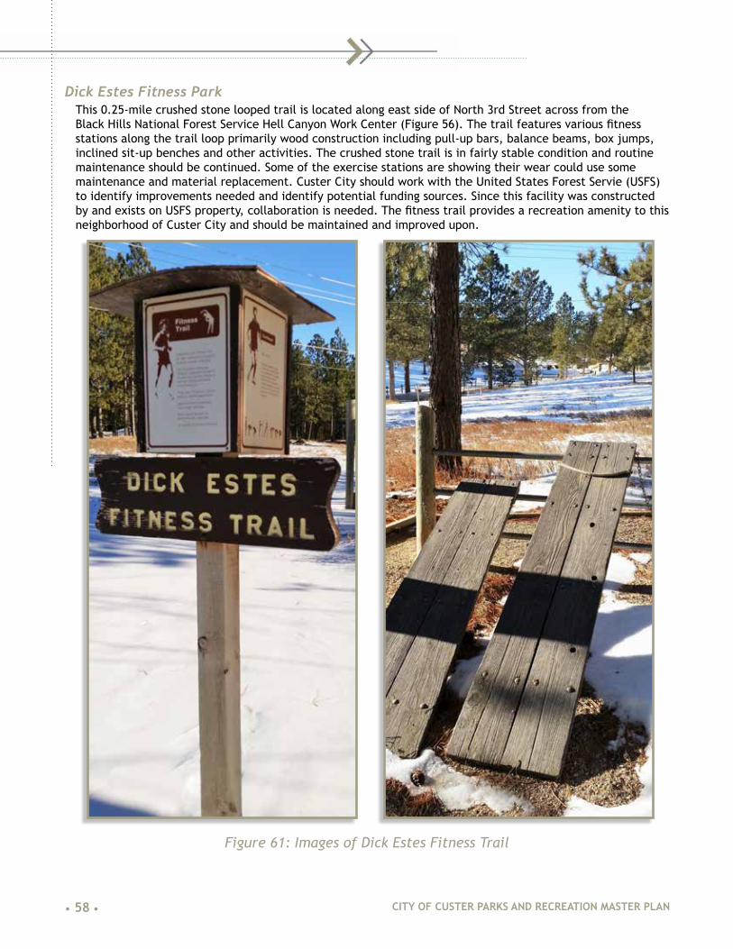
Dick Estes Fitness ParkThis 0.25-mile crushed stone looped trail is located along east side of North 3rd Street across from the Black Hills National Forest Service Hell Canyon Work Center (Figure 56). The trail features various fitness stations along the trail loop primarily wood construction including pull-up bars, balance beams, box jumps, inclined sit-up benches and other activities. The crushed stone trail is in fairly stable condition and routine maintenance should be continued. Some of the exercise stations are showing their wear could use some maintenance and material replacement. Custer City should work with the United States Forest Servie (USFS) to identify improvements needed and identify potential funding sources. Since this facility was constructed by and exists on USFS property, collaboration is needed. The fitness trail provides a recreation amenity to this neighborhood of Custer City and should be maintained and improved upon.
Figure 61: Images of Dick Estes Fitness Trail

CITY OF CUSTER PARKS AND RECREATION MASTER PLAN • 59 •
Rocky Knolls Golf CourseRocky Knolls Golf Course offers a par 36, 9-hole course nestled in the natural ponderosa pine forest of the southern Black Hills (Figure 57). The course is located about 2/3 mile west of downtown Custer City along West US Highway 16. The course opened in 1965 and has a total yardage of 3,085 yards from the longest tee. The course provides an additional recreational activity for Custer City residents and visitors to the area and is an integral part of Custer City’s parks and open space system. The course is managed by a seven-member Board of Directors, general course manager and clubhouse/pro shop manager. An assessment of the course wasn’t included in the scope of work for this parks master plan but several improvements are planned for the course including upgrading the irrigation system, fairway improvements and other course upgrades to increase the golf experience of the course.
Figure 62: Rocky Knolls Golf Course view of hole 5

• 60 • CITY OF CUSTER PARKS AND RECREATION MASTER PLAN
PARK FACILITY INVENTORYAll City of Custer park amenities are depicted in Table 10. The table shows park users have several available park spaces and types of facilities available.
Table 10: Inventory of Developed Park Facilities
Amenities Gat
es
City
Poo
l
Com
mun
ity
Cent
er
Way
Fren
ch
Cree
k
Har
bach
Page
ant
Hill
Big
Rock
Inm
an
Foot
ball
/Tra
ck
Scho
ol
Cam
pus
Picnic Tables 3 2 4 6 10 1 5
Bench 2 6 4 5
Grill 1 4 3
Drinking Fountain 1 1
Dog Waste Station 1
Gazebo/Shelter 2 3 1
Restroom 1 1 1 1 1 1
Playground 1 4 2 1 2
ADA Accessibility Y Y
Parking Areas 1 2 1 2 4 1 2 2
Bike Rack 1 1 2
Lighting 1 1 1
Information Kiosk 1 1
Interpretation 2 2 2
Horseshoe Pit 6
Skateboard Elements 5
Tennis Court 2
Sand Volleyball 4
Irrigation System Y Y
Basketball 1 1 3
Baseball/Softball 1 2
Football Field 2 1
Soccer Field 3
Running Track 1
Bleacher Seating 2 2
Storage Shed 1 6
Disc Golf* 1 1
*Located on both Big Rock Park and Pageant Hill

CITY OF CUSTER PARKS AND RECREATION MASTER PLAN • 61 •
|05| PUBLIC ENGAGEMENTCommunity input and support are critical to a master plan and its development process. Community input helps guide decision-making and programming while community support helps with long-term “buy-in.” The following is the analysis of the community workshops indicating the common themes for the Custer Park system. Participants were asked for their ideas; explanation of park problems, issues, and inadequacies; and to share their vision for the park system.
The master plan divides the stakeholders into two groups, (1) Community Stakeholders and (2) Program Stakeholders. Community stakeholders are individuals, neighbors, concerned citizens and community groups such as dog walkers or running groups.
Program Stakeholders have always been an important and consistent proponent for the Custer Park System. Program Stakeholders are activity and recreation groups that run an organized activity or they are organized groups that have secured a permit from the City of Custer for that activity. The Custer YMCA is the largest program stakeholder; this organization operates programs such as youth archery, tumbling, baseball, T-ball, soccer, basketball, golf, and marital arts. Over the years, the Custer Park System has expanded and developed to accommodate these activities.
PROGRAM STAKEHOLDERSA small focus group meeting was held with the program stakeholders. Various organizations were invited to discuss to the meeting and approximately 15 poeple attended. Discussions focused on how their organization currently used the parks and what their future park and recreation needs might be. Potential improvements were identified, as well as, maintenance needs for the existing parks.
COMMUNITY STAKEHOLDERSThe community stakeholders were engaged through three different formats including:
• A public meeting,
• Presentations with elementary and high school students, and
• A digital survey.
Community members 50 and over were well represented at the public meeting, under 18 was engaged in the school meetings; finally, our team was able to interact with community member between the ages of 25 and 45 with the digital survey. Notifications for the all meetings and surveys were announced through social media (Facebook), flyers, signs in parks, and signs posted in downtown businesses.

• 62 • CITY OF CUSTER PARKS AND RECREATION MASTER PLAN
PUBLIC MEETING NO. 1The first public meeting was held on Tuesday October 25, 2016 (Figure 58). The meeting began with our design team introducing the master planning process; the attendees (approximately 35 individuals) were divided into three groups that rotated between three stations. The stations included:
1. Where I live, what parks to I use and what routes to I take to get to the park?
2. Favorite activity/activities needed/what needs to be fixed
3. New parks/new connections
After the attendees had worked through each station, the entire group participated in a final review and comment period where everyone was able to voice any major concerns, ideas, or issues that were not discussed during the 3-station exercise. All comments and notes were color coded based on an age range, for this meeting 90 percent of the attendees were 55 and over.
Figure 63: Images from Public Meeting No. 1

CITY OF CUSTER PARKS AND RECREATION MASTER PLAN • 63 •
STATION NO. 1 - WHERE I LIVE|WHAT PARKS I USE|WHAT ROUTES I TAKE TO GET TO THE PARK
The three favorite parks of the meetings attendees were Harbach, Big Rock and Pageant Hill. Most travel to parks by automobile, then by bicycle, and finally by walking.
SUMMARY The age group represented by the turnout indicates that individuals over 55 prefer to use Harbach, Big Rock and Pageant Hills Parks. Most drive to the park. Specific corridors through the city began to emerge.
• 3rd street is a major corridor for biking and walking.
• 5th, 7th, and 9th Streets are routes people take with cars.
• Montegomery Street is a major route for bicycles and cars
• The Mickelson Trail is heavily used by bicycles and pedestrians along French Creek, however use drops dramatically when the creek and trail separate.
• Sydney Park Road into Custer is a high use automobile route. Automobile traffic then continues on Washington Street to Gordon Street.
• Bicycle and pedestrian traffic on the southeast section of Custer prefer to use Needles to 10th to Canal to 8th street, following the edge of Pageant Hill Park.
STATION NO. 2 - FAVORITE ACTIVITIES|ACTIVITIES NEEDED|NEEDS TO BE FIXED
Summary Comments From The Individual Parks
Custer School CampusIdea Support Votes Money Votes
Better Soccer Fields 1 $-Additional Sidewalks 3 $10
Unplanned City PropertyIdea Support Votes Money Votes
Dog Park 16 $160
Football Field And TrackIdea Support Votes Money Votes
Connections To And From Senior Center 7 $60More Football Games 1 $56
Iman ParkIdea Support Votes Money Votes
Better Connections To Track And Field 5 $61Make Into A Real Park 2 $0
Community GardenIdea Support Votes Money Votes
New Fencing 0 $-
Gates ParkIdea Support Votes Money Votes

• 64 • CITY OF CUSTER PARKS AND RECREATION MASTER PLAN
Need To Complete West Dam Project 4 $325Need A Bigger Park For Events 0 $-When Water Returns; - Ice Skating And Room Ball Activities 8 $1Dog Park 4 $337Signage For Crossing The Street 1 $-
Way ParkIdea Support Votes Money Votes
Water Fountain To Include Drinking For Dogs 3 $10Bike Friendly Community 3 $100Mark Bike Lanes 7 $30Install A Bandshell 0 $-Maintain The Farmers Market 4 $-Add Audio/Visual For Movies And Music In The Park 2 $67
City PoolIdea Support Votes Money Votes
Maintain The Pool 0 $-
French Creek ParkIdea Support Votes Money Votes
Add Walking And Biking Path Along Gordon Street 1 $-Fix Bridge At 4Th Street 0 $-Fix Bridge At 5Th Street 1 $30Add Benches Along The Mickelson Trail 0 $-Add Benches In The Park 4 $-Beautification For The Gardens 2 $67Add Areas For Fly Fishing 1 $11Add Additional Parking 2 $20Improve Ada Access 1 $-
Old Elementary School Idea Support Votes Money Votes
Complete The Community Center 13 $256Indoor Pool With Outdoor Spray Park 22 $1,214Dog Park, Socializing Area, Ice Rink 0 $-
Harback ParkIdea Support Votes Money Votes
Improve Mickelson Trailhead - $-Update Shelters 0 $-Add Lighting For Evening Events 10 $160Tennis Courts & Skate Park 4 $92New Playground Equipment And Surfacing 7 $-Add Benches Near The Mickelson 0 $150
Big Rock Park

CITY OF CUSTER PARKS AND RECREATION MASTER PLAN • 65 •
Idea Support Votes Money Votes
Add Mountain Bike Trails 7 $352Expand The Trail System 0 $-Trail Signage 0 $50Trail Connection To The Top 0 $-
Pageant HillIdea Support Votes Money Votes
Add Lighting For Evening Sledding 8 $108Install New Shelter 2 $66Add Restroom 3 $-Add Concert Activity 7 $125Develop The East Side For More Use 0 $10Develop Bridge To Pageant Hill From Mickelson Trail 5 $170
STATION NO. 2 SUMMARYAfter all the ideas for the parks were posted the attendees were given $127 to spend on the ideas, essentially voting on the improvement. We look toward the ideas that received high social votes and monetary votes, indicating that the idea is both “like” in concept and people are willing to spend money for the improvement, as they see value in it. The attendees are interested in the following improvements:
• The development of a dog park with an off-leash section.
• The development of solid and safe connections through the city.
• The development of a community-center and an indoor pool complex.
• A high-quality outdoor venue for performances and events. Components of the outdoor venue include lighting, sound, open-space, and support buildings (restrooms, shelters, etc.).
• Trails for biking and walking.
STATION NO. 3 - WHERE NEW PARKS LANDS SHOULD BE DEVELOPED|WHERE NEW CONNECTIONS SHOULD BE MADE
Summary of Comments for New Public Spaces or ParksIdea Support Votes Money Votes
New Park At Boot Hill 2 $1Dog Park At The Unplanned City Property 4 26Develop A Park Near The New Hospital 5 $51Demo Old Hospital And Create Open Space Or A Park 8 $253Repurpose Old Hospital Into Businesses 0 $126Install New Parking Near The Hospital For The Mickelson Trail 2 $5Install New Picnic Shelter And Playground Equipment At Pageant Hill 4 $201New Park In The Alley Between The Custer Vfw Post 3442 And The Claw Antler & Hide Co. 1 $0Develop Improvements To Outdoor Pool And Install A New Indoor Pool 7 $376Develop Inman Park Into An “Actual Park” 11 $-Develop Community Garden Improvements 0 $1

• 66 • CITY OF CUSTER PARKS AND RECREATION MASTER PLAN
Expand Gates Park 3 $105Develop New Outdoor Picnic Areas On The East Side Of The Golf Course 3 $-
Summary Of Comments Regarding New Roads, Bike Paths And SidewalksIdea Support Votes Money Votes
Big Rock Park Trail Improvements 2 $20New Sidewalks Along Sidney Park Ave. And Park Ave. 0 $-New Sidewalks/Bike Paths From The Mickelson Trail Custer State Park Spur To The Custer School Campus 1 $55New Sidewalk/Bike Path From The Mickelson Trail To Pageant Hill Along 8Th St. 0 $-Improved Crossing At The Intersection Of The Mickelson Trail And Mt. Rushmore Road 0 $-New Sidewalks Along Montgomery St. And N. 10Th St./Summit St. 0 $-New Sidewalk Connection From The Football Field/Track To The Mickelson Trail And Inman Park 0 $-New Bike Route Along 3Rd St. From Highway 16/385 To The Mickelson Trail At French Creek Park 0 $-New Sidewalk Along Gordon St. From 4Th St. Westward 0 $5New Bike Path From The Mickelson Trail At Gordon St. To Highway 385 To Highway 16 And Westward 1 $100
ONLINE SURVEY RESULTS A general parks survey was created online to gather data on how residents use the parks, their ages and genders, and their overall satisfaction with the Custer Park System. The largest response of respondents were between the ages of 35 and 54, second largest response was 19 to 34, and 55 plus was the smallest respondent group. 67 percent were female and 33 were male. 85 percent of the respondents live in Custer and 70 percent of those respondents that live in Custer work in Custer. 75 percent of the respondents believed that parks are very important to the quality of life in Custer.
Of all the parks in the Custer system, the community gardens, Inman, and the Disc Golf Course had the greatest frequency of visitors. The Mickleson Trail, The Custer YMCA, and Harbock Park had the lowest visitation frequency. The respondents indicated that they mostly visit the parks to relax; run/walk or jog; and enjoy nature. If the respondents did not use the park, they indicated that the top reasons were that they had no time and that the parks lacked facilities for them.
The three top priorities for the parks system are developing hiking and biking trails, keeping natural areas, and installing playground equipment. A majority found the general upkeep and maintenance of the existing park spaces good (52 percent) while only 15 percent found them excellent. Of the trails to be developed, most indicated that they should be for exercise and recreation.
When asked about groups of residents that are underserved, the respondents indicated that the ages of 15 to 18 are the most underserved group, followed by ages 10 to 15.
A majority indicated that building new facilities such as a sports field, community centers or indoor swimming pools and upgrading the existing parks would be greatest improvement for the park system. A very low number of respondents indicated that developing new parkland or even acquiring land for parks would make the system better. If funding were to become available, the respondents indicated that an indoor swimming pool, a multi-purpose indoor community center and a thoroughly connected inter-city trail/sidewalk system

CITY OF CUSTER PARKS AND RECREATION MASTER PLAN • 67 •
are the highest priorities. The top two city services that respondents would like money spent on are parks, trails, open spaces, and recreational opportunities.
The three most important policies according to residents were that the parks should be for the residents, protect natural areas, and provide the public with access to land. The three least important policies for the parks were to build or renovate parks for tourists, generate revenue from users, and acquire new land for future parks.
In summary, the respondents want the Custer Park System to be designed, built, and maintained for the citizens of Custer. They feel that there is adequate land available to support the current population and uses. The existing parks should be upgraded with new uses and planned with more recreation activities including hiking, biking, un-programmed open space and nature exploration. The parks should protect the city and the natural environment.
ELEMENTARY SCHOOL INPUT SESSIONSThe Design Team worked with grades 4th through 6th to ask their opinions on the Custer Park System. The kids were asked what their two favorite parks in the city were, what they liked about the parks, what need to be added, and what needed to be fixed. The following is a summary of the students’ comments:
The top three favorite parks are (in ranking order):
1. The football field adjacent to Inman Park
2. The City Pool
3. Harback Park
The three lowest ranking parks include:
1. Way Park
2. The Mickelson Trail
3. The Disc Course and Rocky Knolls Golf Course
Summary of comments of favorite activities, activities needed and things that need to be fixed.
Custer School CampusIdea Support Votes
Kids Museum 0Indoor Soccer Field 0Golf 0Pool 4Huge Slide 3Trampoline Park 0Playground Set 0Field Goals 1New Fence For The Baseball Field 0
Unplanned City PropertyIdea Support Votes
A Very Big Pond With Fish 0Add Playground And Zipline 0New Skate Park 0
Pageant Hill

• 68 • CITY OF CUSTER PARKS AND RECREATION MASTER PLAN
Idea Support Votes
Park 0Swing Set 0More Fun Things 0
Big Rock ParkIdea Support Votes
Rock Climbing Place 2Bike Circuit To Bike Down Hill 1Playground 0Water Park 0Skate Park 0
Harbach ParkIdea Support Votes
A Big Playhouse 0Skate Park 1Picnic Area 0Treehouse 4Adventure Land 0Zipline 4Picnic Shelter 0Trampoline Park 5Petting Zoo 1Ga-Ga Ball 1Banana Swing 1Mini Indoor Golf 0Basketball Court 6Volleyball Court 3
Way ParkIdea Support Votes
Bars To Swing On 0Indoor Pool 0Sky Ride 0Golf 0Ice Skating Rink 0Set Of Swings 0Fountain Park 1
French Creek ParkIdea Support Votes
Water Park 4Amusement Park 1Fish 3Hiking Park 1Play Room 0

CITY OF CUSTER PARKS AND RECREATION MASTER PLAN • 69 •
Zipline 3Teeter-Totter 1New Swing Set 0Bike Rack 1Tree House 8Jump Craz 47Trampolines 39Indoor Pool 2Basketball Court 1Keep It As Is 3Merry Go-Round 1
Football Field And TrackIdea Support Votes
Jump Craz 1Zipline 0Waterslide 2The Ravens Own Football Field 7Bungee Jumping 1Add Park 0Trampolines 0Better Field For Football And New Fencing 1Field Lights 1
Inman ParkIdea Support Votes
Vegetable Garden 0Swings 1Pool 0Sky-Line 7Water Park 2Play Space 1Jump Craz 26
Gates ParkIdea Support Votes
Big Garden 0Zipline 40Big Sandy Beach 0Hockey Court 1Good Stand 0Lake 3Monkey Bars 2Merry Go-Round 0Music 0
SUMMARY

• 70 • CITY OF CUSTER PARKS AND RECREATION MASTER PLAN
The elementary students are an active group of kids and their interest in parks reflect this. They prefer parks with activities, the passive parks or parks with low-activity programming ranked the lowest in popularity. Traditional park play structures such as swings, play structures and games when put forth to the group as an idea for installation were never supported. It appears the students prefer sports, unprogrammed spaces, high activity programming, and sensory and imagination sourced play.

CITY OF CUSTER PARKS AND RECREATION MASTER PLAN • 71 •
PUBLIC MEETING NO. 2To be insterted after Public Meeting No 2.

• 72 • CITY OF CUSTER PARKS AND RECREATION MASTER PLAN
|06| LEVEL OF SERVICE (LOS) ANALYSISLevel of Service standards for parks, greenways, and open space have been developed by the National Recreation and Parks Association (NRPA). These standards provide a guide for communities to assess how well they are serving their residents in terms of parks, recreation, and open space opportunities. The NRPA has provided this information for general guidance realizing that each community is different and each has its own unique needs. Community demographics such as age distribution play an important part in determining park amenities and types. For instance, Custer has a larger than average senior population (26.5% greater than age 65) which will have different park requirements than a community with a larger population of school age children or young adults. Using the NRPA standards, as well as case study communities, a narrative can be developed of how well the community is being served in regards to parks and recreation facilities.
PARK CLASSIFICATIONFor the purposes of the Parks and Recreation Master Plan, the following park classifications are used.
Pocket (Mini) ParkThe pocket park or mini park is used to address limited, isolated, or unique recreation needs of concentrated populations. The size of a mini-park ranges between 2,500 square feet and one acre in size. These parks may be either active or passive, but address a specific recreational need rather than a particular population density, although a high population density may create a specific recreation need. Recommended improvements for mini parks may include a small pavilion, picnic area, park benches, and a 6-foot-wide perimeter trail. Off-street parking is not recommended. Pocket parks are the smallest classification and include plazas, scenic overlooks, tot lots and landscaped public areas. These parks are usually less than one acre in size and provide passive recreation to nearby residents or visitors. Pocket parks have a localized service radius, are within walking distance and provide limited recreational needs. Amenities provided by pocket parks generally include picnic table(s), benches, landscaping and possibly a small playground. Custer City parks classified as Pocket include:
» Way Park (0.5 ac, see Figure 59)
» Veterans Memorial Park (0.25 ac)
Figure 64: Way Park is an example of a pocket park

CITY OF CUSTER PARKS AND RECREATION MASTER PLAN • 73 •
Neighborhood ParkNeighborhood parks provide recreational space for residents of nearby neighborhoods. They can range in size from 1- 5 acres and usually quality pedestrian connections such as a trail or sidewalk to residents within the service radius. Neighborhood parks are often combined with a school and are located on fully developable land. Parks classified as Neighborhood include:
» Community Center (3.0 ac)
» Custer School Playgrounds (0.71 ac)
» French Creek Park (2.0 ac, see Figure 60)
Figure 65: French Creek Park serves as a neighborhood park

• 74 • CITY OF CUSTER PARKS AND RECREATION MASTER PLAN
Community ParkCommunity parks are larger than a neighborhood parks and provide amenities for use by the entire community. By offering a variety of activities and amenities, community parks appeal to a broader range of residents and visitors. These parks are typically larger than 5 acres and provide amenities such as restrooms and drinking fountains accommodating longer stays at the park. Parks classified as Community include:
» Harbach Park (3.6 ac, see Figure 61)
» Gates Park/West End (15.5 ac)
Figure 66: Harbach Park is a community park that provides a variety of activities
Special UseSpecial use parks provide a unique type of service or use to the community, rather than a full range of activities. No service radius is assigned to special use parks because users travel to the park for a specific use regardless of proximity. Special use parks include swimming pools, skate parks, sporting fields, festival areas, dog parks. Parks classified as Special Use include:
» City Pool
» Community Gardens
» Custer School Campus Sports Fields
» Custer Skate Park
» Football Field/Track
» Rocky Knolls Golf Course

CITY OF CUSTER PARKS AND RECREATION MASTER PLAN • 75 •
Open Space/Natural AreaThese types of parks are usually located on environmentally sensitive lands, steep terrain, forested areas, water bodies, and/or other land that is minimally developed. The size of these parks varies greatly but they are often used for conservation areas, wildlife viewing areas, and other passive recreation opportunities. There are no specific standards for how much open space a community should provide as it is highly dependent on location, availability of land, and historical resources present. Custer benefits from the adjacency of the Black Hills National Forest and other undeveloped open space. Custer has several opportunities to acquire open space for preserving natural areas, wetlands and view sheds. Current park areas that fall into Open Space/Natural Area are:
» Inman Park
» Big Rock Park (see Figure 62)
» Dick Estes Fitness Trail
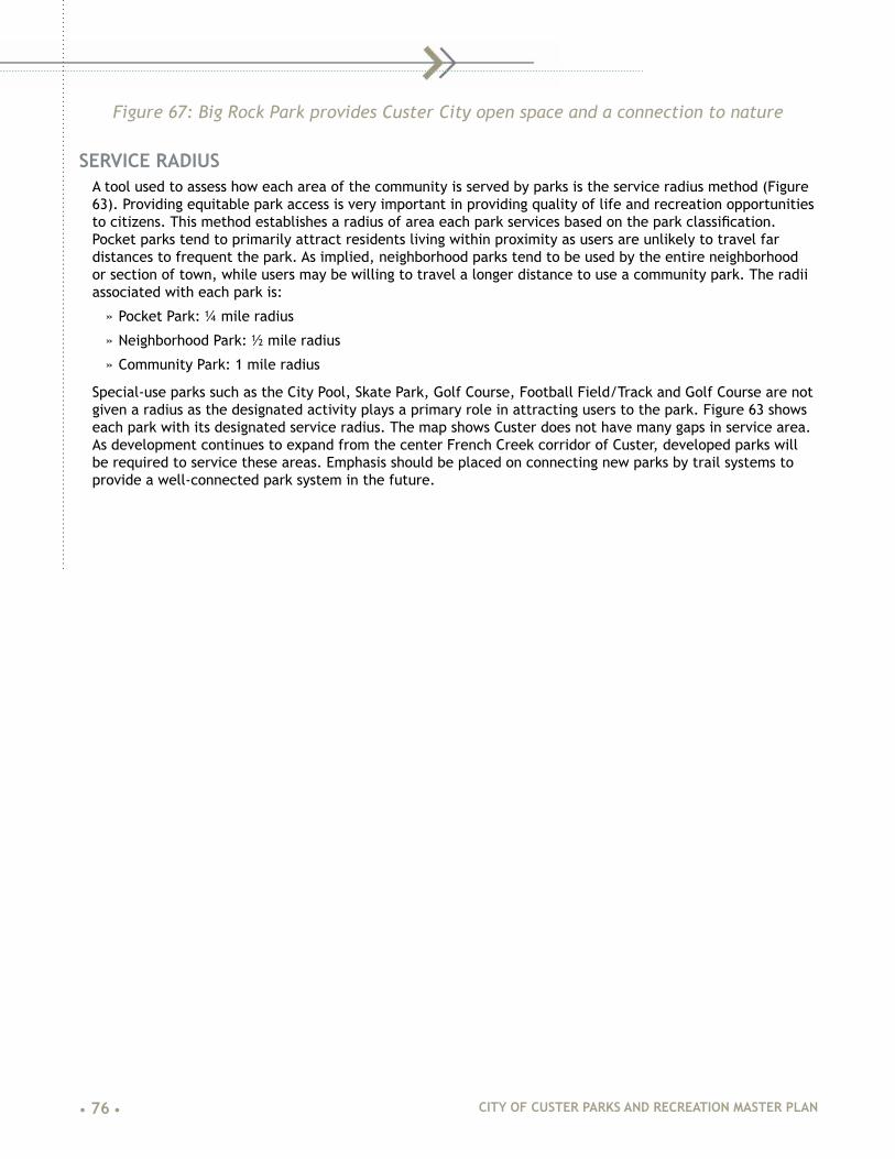
• 76 • CITY OF CUSTER PARKS AND RECREATION MASTER PLAN
Figure 67: Big Rock Park provides Custer City open space and a connection to nature
SERVICE RADIUSA tool used to assess how each area of the community is served by parks is the service radius method (Figure 63). Providing equitable park access is very important in providing quality of life and recreation opportunities to citizens. This method establishes a radius of area each park services based on the park classification. Pocket parks tend to primarily attract residents living within proximity as users are unlikely to travel far distances to frequent the park. As implied, neighborhood parks tend to be used by the entire neighborhood or section of town, while users may be willing to travel a longer distance to use a community park. The radii associated with each park is:
» Pocket Park: ¼ mile radius
» Neighborhood Park: ½ mile radius
» Community Park: 1 mile radius
Special-use parks such as the City Pool, Skate Park, Golf Course, Football Field/Track and Golf Course are not given a radius as the designated activity plays a primary role in attracting users to the park. Figure 63 shows each park with its designated service radius. The map shows Custer does not have many gaps in service area. As development continues to expand from the center French Creek corridor of Custer, developed parks will be required to service these areas. Emphasis should be placed on connecting new parks by trail systems to provide a well-connected park system in the future.

CITY OF CUSTER PARKS AND RECREATION MASTER PLAN • 77 •
CIT
Y LI
MIT
S
CITY
LIM
ITS
CIT
Y LI
MIT
S
CITY LIMITS
CUST
ER S
TATE
PAR
K SP
UR
MICKELSON TRAIL
MT. R
USHM
ORE
RD.
HWY.
16A
HWY 385
HWY.
16
HWY. 89
HWY. 16/3
85
CENTENNIAL DR.
5TH ST.
MONT
GOME
RY S
T.
8TH ST.
3RD ST.
WILD
CAT L
N.
11TH ST.
CANA
L ST.
SIDNEY PARK RD.
SYLVAN LAKE RD.
SHER
MAN
ST.
CIT
Y LI
MIT
S
CIT
Y LI
MIT
S
CROO
K ST
.
HARN
EY S
T.
LITTLE ITALY RD.
1 2
3
45
6
7
8
9
10
11
12
13
14
1516
MICKELSON TRAIL
LOC
ATIO
N K
EY
POC
KET
PA
RK
(1/4
MIL
E S
ER
VIC
E R
AD
IUS
)1
- WAY
PA
RK
NEI
GH
BO
RH
OO
D P
AR
K(1
/2 M
ILE
SE
RV
ICE
RA
DIU
S)
2 - F
RE
NC
H C
RE
EK
PA
RK
3 - C
OM
MU
NIT
Y C
EN
TER
4 - C
US
TER
SC
HO
OL
CA
MP
US
CO
MM
UN
ITY
PAR
K(1
MIL
E S
ER
VIC
E R
AD
IUS
)5
- HA
RB
AC
H P
AR
K6
- GAT
ES
PA
RK
OTH
ER P
AR
KS
/ PU
BLI
C
7 - C
OM
MU
NIT
Y G
AR
DE
N8
- RO
CK
Y K
NO
LLS
GO
LF C
OU
RS
E9
- CIT
Y P
OO
L10
- A
RM
OR
Y11
- B
IG R
OC
K P
AR
K12
- PA
GE
AN
T H
ILL
13 -
INM
AN
PA
RK
14 -
FOO
TBA
LL F
IELD
& T
RA
CK
15 -
UN
PLA
NN
ED
CIT
Y P
RO
PE
RTY
16 -
YM
CA
17 -
VE
TER
AN
S M
EM
OR
IAL
PAR
K18
- D
ICK
ES
TES
FIT
NE
SS
TR
AIL
17
18
LEG
END
MA
JOR
PE
DE
STR
IAN
C
ON
NE
CTI
ON
MIN
OR
PE
DE
STR
IAN
C
ON
NE
CTI
ON
AD
DIT
ION
AL
PE
DE
STR
IAN
C
RO
SS
ING
UN
DE
RS
ER
VE
D A
RE
A
PO
TEN
TIA
L FU
TUR
EU
ND
ER
SE
RV
ED
AR
EA
MIC
KE
LSO
N T
RA
IL(E
XIS
TIN
G)
PAR
K N
OTE
D W
ITH
S
ER
VIC
E A
RE
A
BOOTHILL LOOP
Figure 68: Service Radius Map

• 78 • CITY OF CUSTER PARKS AND RECREATION MASTER PLAN
DEVELOPED PARK ACREAGE AND AMENITIESThe National Recreation and park Association (NRPA) establishes national standards for various park amenities and facility service, per local population. Table 11 summarizes the NRPA level of service standards and how the Custer City park system compares to these standards.
Custer has a higher than average supply for all facilities identified in the Table. These facilities should serve Custer City well into the future as the population grows.
Table 11: NRPA Level of Service Standards Comparison
Custer City
Inventory
Custer City Service Level per Population
NRPA 2009 Standard Level per Population
NRPA Standard
Met?
Park Type
Pocket (Mini) Park .75 Acres .375 Acres 1,000 .5 Acres 1,000 No
Neighborhood Park 5.71 Acres 2.86 Acres 1,000 2 Acres 1,000 Yes
Community Park 19.1 Acres 9.55 Acres 1,000 5 Acres 1,000 Yes
Linear Park 18.9 Acres 8.95 Acres 1,000 7 Acres 1,000 Yes
Outdoor Amenities
Playgrounds 6 6 Per 2,000 1 Playground 2,000 Yes
Picnic Shelters 4 9 Per 2,000 1 Structures 2,000 Yes
Baseball Field 1 1.5 Per 3,000 1 Field 3,000 Yes
Softball Field 2 3 Per 3,000 1 Field 3,000 Yes
Soccer Fields 1 2 Per 4,000 1 Field 4,000 Yes
Football Fields 1 10 Per 20,000 1 Field 20,000 Yes
Swimming Pools 1 10 Per 20,000 1 Pool 20,000 Yes
Running Track 1 10 Per 20,000 1 Track 20,000 Yes
Outdoor Basketball 2 5 Per 5,000 1 Court 5,000 Yes
Tennis Court 2 2 Per 2,000 1 Court 2,000 Yes
Horseshoe Pits 6 22.5 Per 7,500 1 Pit 7,500 Yes
Sand Volleyball Courts 4 10 Per 5,000 1 Court 5,000 Yes

CITY OF CUSTER PARKS AND RECREATION MASTER PLAN • 79 •
COMMUNITY COMPARISONIn addition to NRPA Standards, four communities were compared to Custer City in terms of parks acreage per 1000 residents. These communities were chosen due to their similarities as towns which place an importance on outdoor activities. Two communities from Colorado, Salida and Crested Butte, one community from Montana, Red Lodge, and one community from South Dakota, Rapid City, were compared in Table 12.
Table 12: Community Comparison
Custer City, SD Salida, CO Crested Butte, CO
Red Lodge, MT
Rapid City, SD
Park Type
Total Developed Parks Acres 26 42 30 48 1,650
Population 2,000 5,409 1,509 2,155 72,638
Acres per 1000 Population 13 8 20 22 23
*Calculations do not include undeveloped open space/natural areas
Custer City has more developed park acres per capita than Salida, Colorado but is substantially lower than Crested Butte, Red Lodge and Rapid City which all have over 20 Acres per 1,000 residents. Salida has a large amount of undeveloped greenspace and trail corridor that is not accounted for in Table 12.
SUMMARYOverall, Custer City meets and exceeds NRPA Standards for public open space in terms of acreage per 1,000 resdidents. However, park acreage lacks equitable distribution across Custer City neighborhoods. As the city continues to grow and develop, areas for neighborhood parks need to be identified to provide a more equitable distribution of park land.

• 80 • CITY OF CUSTER PARKS AND RECREATION MASTER PLAN
|07| PARK RECOMMENDATIONS & PRIORITIES
RANKING CRITERIAThe ranking criteria for recommended park improvements contains seven categories in which each project is scored. The seven categories are Recreation/User Value, Health and Safety, Public Input, Operation and Maintenance, Land Acquisition, and Planning Goals and Livability. Each category has been giving a weight from 1 to 7 based on how important the category plays into the decision. The category score for each project is multiplied by the categorical weighting to attain a weighted score. The sum of the weighted scores provides the project a total score and this total score is used to prioritize the various projects.
RECREATION AND USER BENEFIT (WEIGHT = 6)This category is based on the recreational benefits that users of the facility will incur upon completion of the project. Providing added recreation opportunities for Custer City residents and visitors is a major priority in the parks system and is weighed second highest as a 6. Scores for cost are given according to the following criteria:
1 = Project will not affect usability, functionality or facility aesthetics as seen by the user.
2 = Project will increase overall usability, functionality and/or aesthetics of the park system for the user.
3 = Project will greatly increase available amenities and/or overall usability, functionality and/or aesthetics of the park system for the user.
HEALTH AND SAFETY (WEIGHT = 4)This category deals with protecting the health and safety of the parks and recreation user at Custer City parks and recreation facilities. A weight of 4 was given to the category and projects were scored according to the following criteria:
1 = Health and safety of the parks and recreation user will be minimally or not affected.
2 = Project will increase the health and safety of the parks and recreation user.
3 = Project is critical to ensuring health and safety to park and recreation users and/or is required by federal, state or local laws.
PUBLIC INPUT (WEIGHT = 3)This category addresses input from various meetings, public input sessions and surveys throughout the parks master planning process. A weight of 3 is given to the category and projects were scored according to the following criteria:
1 = Project was identified as a need by design team but not mentioned during public input meetings, surveys or interviews.
2 = Project was suggested 1-2 times during public input meetings, surveys or interviews.
3 = Project ranked as a high priority by user organization and was suggested by multiple participants during public input meetings, surveys or interviews.
PROJECT COST (WEIGHT = 7)This category is based on the total cost to complete each project. Cost is always a strong factor in determining priorities and the decision-making process. Project Cost has been given the highest weighting factor. Scores for cost are given according to the following criteria:
1 = $100,000+
2 = $30,000 - $100,000

CITY OF CUSTER PARKS AND RECREATION MASTER PLAN • 81 •
3 = $15,000 - $30,000
4 = $5,000 - $15,000
5 = Under $5,000
OPERATION AND MAINTENANCE (WEIGHT = 5)This category evaluates the cost and time of the operation and maintenance associated with each project. The continued operation and maintenance of a facility is an extremely important factor because it can be burdensome to communities when summed over multiple years. Due to this consideration, this category is weighted at 5. Scores are assigned comparative to current O&M requirements as follows:
1 = Will increase amount of O&M required by city and/or caretaker organization
2 = Will not affect amount of required O&M or will slightly reduce O&M hours
3 = Will decrease amount of O&M costs or number of hours currently spent maintaining park/facility.
LAND ACQUISITION (WEIGHT = 2)This category accounts for the feasibility of completing the improvement or project based on land requirements. Acquiring land or easements is costly and time consuming. A weight of 2 is given to this category and is scored according the following criteria:
1 = Will be difficult to obtain land, easement, right-of-way, or other required land elements needed to complete the project.
2 = Project will require land, easement, right-of-way, or other required rights to complete the project but is foreseen as feasible and achievable.
3 = Custer City currently possesses required land resources (not including funds) to complete the project.
PLANNING GOALS AND LIVABILITY (WEIGHT = 1)The category evaluates how the proposed improvement coincides with other adopted city planning documents and how the improvement affects the overall livability of Custer City.
1 = Project does not address goals/needs identified in other city plans or improve the overall livability of the community.
2 = Completion of the project addresses goals/needs or other adopted city planning documents but does not directly achieve them or slightly improves the overall livability of the community.
3 = Completion of the project directly helps achieve goals/needs identified in adopted city planning documents or significantly improves the overall livability of the community.
DEVELOPED PARK IMPROVEMENTSSeveral park and recreation improvements have been identified during the review and evaluation of Custer City parks and recreation facilities. These projects have been entered in the parks improvement priority matrix shown in Table 13, on the following 3 pages. This priority matrix will assist Custer City in identifying projects to fund and complete in a logical and meaningful way. The improvements are grouped by park and then sorted according to Total Score from high to low.
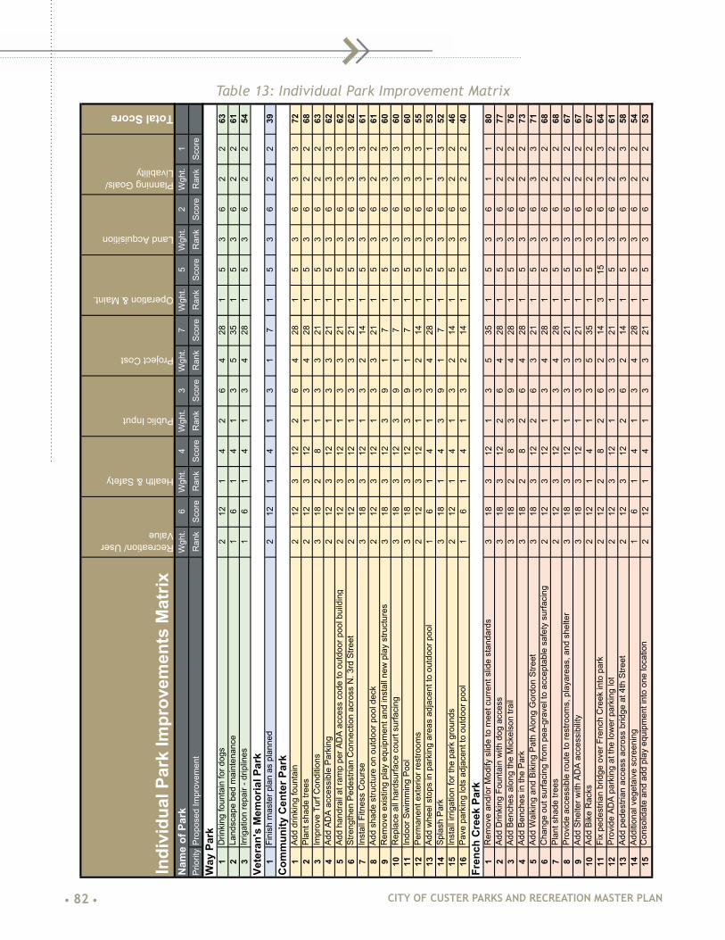
• 82 • CITY OF CUSTER PARKS AND RECREATION MASTER PLAN
Table 13: Individual Park Improvement Matrix
Indi
vidu
al P
ark
Impr
ovem
ents
Mat
rix
Recreation/ User Value
Health & Safety
Public Input
Project Cost
Operation & Maint.
Land Acquisition
Planning Goals/ Livability
Total Score
Nam
e of
Par
kW
ght.
6W
ght.
4W
ght.
3W
ght.
7W
ght.
5W
ght.
2W
ght.
1Pr
iorit
yPr
opos
ed Im
prov
emen
tR
ank
Scor
eR
ank
Scor
eR
ank
Scor
eR
ank
Scor
eR
ank
Scor
eR
ank
Scor
eR
ank
Scor
eW
ay P
ark
1D
rinki
ng fo
unta
in fo
r dog
s2
121
42
64
281
53
62
263
2La
ndsc
ape
bed
mai
nten
ance
16
14
13
535
15
36
22
613
Irrig
atio
n re
pair
- drip
lines
16
14
13
428
15
36
22
54Ve
tera
n's
Mem
oria
l Par
k1
Fini
sh m
aste
r pla
n as
pla
nned
212
14
13
17
15
36
22
39C
omm
unity
Cen
ter P
ark
1Ad
d dr
inki
ng fo
unta
in2
123
122
64
281
53
63
372
2Pl
ant s
hade
tree
s2
123
121
34
281
53
62
268
3Im
prov
e Tu
rf C
ondi
tions
318
28
13
321
15
36
22
634
Add
ADA
acce
ssib
le P
arki
ng2
123
121
33
211
53
63
362
5Ad
d ha
ndra
il at
ram
p pe
r AD
A ac
cess
cod
e to
out
door
poo
l bui
ldin
g2
123
121
33
211
53
63
362
6St
reng
then
Ped
estri
an C
onne
ctio
n ac
ross
N. 3
rd S
treet
212
312
13
321
15
36
33
627
Inst
all F
itnes
s C
ours
e3
183
121
32
141
53
63
361
8Ad
d sh
ade
stru
ctur
e on
out
door
poo
l dec
k2
123
121
33
211
53
62
261
9R
emov
e ex
istin
g pl
ay e
quip
men
t and
inst
all n
ew p
lay
stru
ctur
es3
183
123
91
71
53
63
360
10R
epla
ce a
ll ha
rdsu
rface
cou
rt su
rfaci
ng3
183
123
91
71
53
63
360
11In
door
Sw
imm
ing
Pool
318
312
39
17
15
36
33
6012
Perm
anen
t ext
erio
r res
troom
s2
123
121
32
141
53
63
355
13Ad
d w
heel
sto
ps in
par
king
are
as a
djac
ent t
o ou
tdoo
r poo
l1
61
41
34
281
53
61
153
14Sp
lash
Par
k3
181
43
91
71
53
63
352
15In
stal
l irri
gatio
n fo
r the
par
k gr
ound
s2
121
41
32
141
53
62
246
16Pa
ve p
arki
ng lo
ts a
djac
ent t
o ou
tdoo
r poo
l1
61
41
32
141
53
62
240
Fren
ch C
reek
Par
k1
Rem
ove
and/
or M
odify
slid
e to
mee
t cur
rent
slid
e st
anda
rds
318
312
13
535
15
36
11
802
Add
Drin
king
Fou
ntai
n w
ith d
og a
cces
s3
183
122
64
281
53
62
277
3Ad
d Be
nche
s al
ong
the
Mic
kels
on tr
ail
318
28
39
428
15
36
22
764
Add
Benc
hes
in th
e Pa
rk3
182
82
64
281
53
62
273
5Ad
d W
alki
ng a
nd B
ikin
g Pa
th A
long
Gor
don
Stre
et3
183
122
63
211
53
63
371
6C
hang
e ou
t sur
faci
ng fr
om p
ea-g
rave
l to
acce
ptab
le s
afet
y su
rfaci
ng2
123
121
34
281
53
62
268
7Pl
ant s
hade
tree
s2
123
121
34
281
53
62
268
8Pr
ovid
e ac
cess
ible
rout
e to
rest
room
s, p
laya
reas
, and
she
lter
318
312
13
321
15
36
22
679
Add
Shel
ter w
ith A
DA
acce
ssib
ility
318
312
13
321
15
36
22
6710
Add
Bike
Rac
ks2
121
41
35
351
53
62
267
11Fi
x pe
dest
rian
brid
ge o
ver F
renc
h C
reek
into
par
k2
122
82
62
143
153
63
364
12Pr
ovid
e AD
A pa
rkin
g at
the
low
er p
arki
ng lo
t2
123
121
33
211
53
62
261
13Ad
d pe
dest
rian
acce
ss a
cros
s br
idge
at 4
th S
treet
212
312
26
214
15
36
33
5814
Addi
tiona
l veg
etai
ve s
cree
ning
16
14
13
428
15
36
22
5415
Con
solid
ate
and
add
play
equ
ipm
ent i
nto
one
loca
tion
212
14
13
321
15
36
22
53

CITY OF CUSTER PARKS AND RECREATION MASTER PLAN • 83 •
Individual Park Improvement Matrix continued
Indi
vidu
al P
ark
Impr
ovem
ents
Mat
rix
Recreation/ User Value
Health & Safety
Public Input
Project Cost
Operation & Maint.
Land Acquisition
Planning Goals/ Livability
Total Score
Nam
e of
Par
kW
ght.
6W
ght.
4W
ght.
3W
ght.
7W
ght.
5W
ght.
2W
ght.
1Pr
iorit
yPr
opos
ed Im
prov
emen
tR
ank
Scor
eR
ank
Scor
eR
ank
Scor
eR
ank
Scor
eR
ank
Scor
eR
ank
Scor
eR
ank
Scor
e
Gat
es P
ark
1Im
prov
e Pe
dest
rian
acce
ss a
t Litt
le It
ally
Roa
d3
183
122
63
211
53
63
371
2Ad
d ra
ised
pla
nter
bed
s - C
omm
unity
Gar
dens
318
14
13
428
15
36
22
663
Acce
ssib
le S
urfa
cing
- C
omm
unity
Gar
dens
212
28
13
428
15
36
22
644
Add
Benc
hes
- Com
mun
ity G
arde
ns2
122
81
34
281
53
62
264
5Ad
d fe
nced
dog
par
k w
est o
f sof
tbal
l fie
ld3
181
42
63
211
53
61
161
6Im
plem
ent t
he d
evel
oped
mas
ter p
lan
318
312
39
17
15
36
33
607
Expa
nd th
e m
aste
r pla
n to
incl
ude
area
eas
t of d
am to
Waz
i Lan
e1
62
81
34
281
53
63
359
8C
onne
ct to
Par
k to
trai
l sys
tem
318
312
39
17
15
24
33
589
Dev
elop
Par
king
are
a (a
spha
lt or
gra
vel)
- Com
mun
ity G
arde
ns2
122
81
33
211
53
61
156
10Al
l pat
h pa
ving
is re
com
men
ded
to b
e co
ncre
te3
183
121
31
71
53
61
152
11In
stal
l irri
gatio
n on
sof
tbal
l fie
ld2
121
41
33
211
53
61
152
12N
ew fe
ncin
g ar
ound
Com
mun
ity G
arde
ns1
61
42
63
211
53
61
149
13Pa
rkin
g Lo
t and
Saf
ety
Ligh
ting
16
312
13
214
15
36
11
47
14D
evel
op a
dditi
onal
pic
nic
shel
ters
thro
ugh
park
(by
Com
mun
ity G
arde
ns)
212
14
13
214
15
36
11
45H
arba
ch P
ark
1C
ompl
ete
side
wal
k co
nnec
tions
to d
ownt
own
318
312
26
428
210
36
22
822
Rev
ise
drin
king
foun
tain
to p
rovi
de A
DA
acce
ssib
ility
212
312
13
535
210
36
22
803
Rep
lace
pla
y eq
uipm
ent a
nd s
urfa
cing
318
312
39
214
315
36
22
764
Impr
ove
stre
am h
abita
t3
183
122
63
212
103
62
275
5D
evel
op a
Par
k M
aste
r Pla
n3
181
41
33
213
153
63
370
6R
epla
ce p
edes
trian
brid
ge a
cros
s Fr
ench
Cre
ek3
183
121
32
143
153
61
169
7Pl
ant s
hade
tree
s2
122
81
34
282
103
62
269
8R
emov
e al
l har
d su
rface
pla
y co
urts
16
28
13
321
210
36
11
559
Dev
elop
Mic
kels
on T
railh
ead
212
14
26
214
210
36
22
54
10Ar
ea fo
r har
d su
rface
pla
y co
urts
to b
ecom
e pa
rk p
avilio
n an
d ou
tdoo
r pe
rform
ance
ven
ue3
181
41
32
141
53
61
151
11Im
prov
e Pa
rkin
g Ar
eas
212
14
13
214
210
36
11
5012
Rel
ocat
e sk
ate
park
to C
omm
unity
Cen
ter P
ark
212
14
13
214
210
36
11
5013
Add
addi
tiona
l she
lters
212
14
26
214
15
36
11
4814
Inst
all f
estiv
al p
erfo
rman
ce a
rea
318
14
26
17
15
36
11
4715
Add
park
pav
ilion
318
14
13
17
15
36
11
4416
Rem
ove
sect
ion
of W
ashi
ngto
n St
reet
bet
wee
n 7t
h an
d 8t
h St
reet
212
14
13
214
15
24
11
43
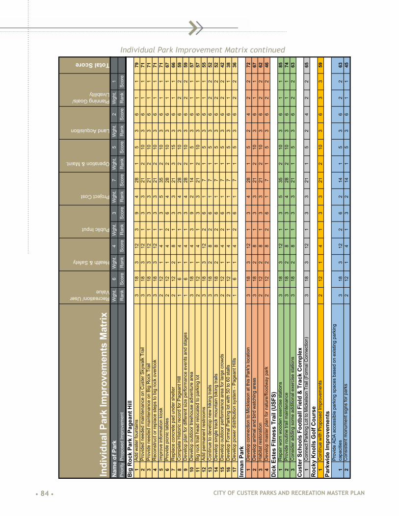
• 84 • CITY OF CUSTER PARKS AND RECREATION MASTER PLAN
Individual Park Improvement Matrix continued
Indi
vidu
al P
ark
Impr
ovem
ents
Mat
rix
Recreation/ User Value
Health & Safety
Public Input
Project Cost
Operation & Maint.
Land Acquisition
Planning Goals/ Livability
Total Score
Nam
e of
Par
kW
ght.
6W
ght.
4W
ght.
3W
ght.
7W
ght.
5W
ght.
2W
ght.
1Pr
iorit
yPr
opos
ed Im
prov
emen
tR
ank
Scor
eR
ank
Scor
eR
ank
Scor
eR
ank
Scor
eR
ank
Scor
eR
ank
Scor
eR
ank
Scor
e
Big
Roc
k Pa
rk /
Page
ant H
ill1
Add
wat
er fo
unta
ins
318
312
39
428
15
36
11
792
Prov
ided
nee
ded
mai
nten
ance
on
Cus
ter S
kyw
alk
Trai
l3
183
121
33
212
103
61
171
3Pr
ovid
e ne
eded
mai
nten
ance
on
Big
Roc
k Tr
ail
318
312
13
321
210
36
11
714
Rec
onst
ruct
or r
epla
ce s
teps
to b
ig ro
ck o
verlo
ok3
183
121
33
212
103
61
171
5Im
prov
e in
form
atio
n ki
osk
212
14
13
535
210
36
11
716
Prov
ide
picn
ic ta
bles
212
14
26
428
210
36
11
677
Rep
lace
con
cret
e pa
d un
der s
helte
r2
122
81
33
213
153
61
166
8C
ompl
ete
His
toric
reco
rd fo
r Pag
eant
Hill
16
14
13
428
210
36
22
599
Dev
elop
pla
n fo
r diff
eren
t siz
e pe
rform
ance
eve
nts
and
stag
es1
61
41
34
282
103
62
259
10D
evel
op o
utdo
or tr
eeho
use
adve
ntur
e ar
ea3
181
43
92
141
53
61
157
11Bi
g ro
ck tr
ail h
ead
relo
cate
d to
par
king
lot
212
14
13
321
210
36
11
5712
Add
perm
anen
t res
troom
s3
183
122
61
71
53
61
155
13C
ontin
ue to
dev
elop
new
hik
ing
trails
318
28
26
17
15
36
22
5214
Dev
elop
sin
gle
track
mou
ntai
n bi
king
trai
ls3
182
82
61
71
53
62
252
15D
evel
op o
utdo
or p
erfo
rman
ce a
rea
for l
arge
cro
wds
212
14
26
17
15
36
22
4216
Dev
elop
For
mal
Par
king
lot w
ith 5
0 to
60
stal
ls2
121
41
31
71
53
61
138
17D
evel
op p
ower
dis
tribu
tion
syst
em -
Page
ant H
ills1
61
42
61
71
53
62
236
Inm
an P
ark
1D
evel
op c
onne
ctio
n to
Mic
kles
on a
t thi
s Pa
rk's
loca
tion
318
312
13
428
15
24
22
722
Dev
elop
ani
mal
and
bird
wat
chin
g ar
eas
318
28
13
321
210
36
11
673
Hab
itat r
esto
ratio
n2
122
81
33
212
103
62
262
4D
evel
op m
aste
r pla
n fo
r nat
ure/
flood
way
par
k2
122
82
61
71
53
62
246
Dic
k Es
tes
Fitn
ess
Trai
l (U
SFS)
1R
epai
r wor
n w
oode
n ex
erci
se s
tatio
ns3
183
121
35
352
103
61
185
2Pr
ovid
e ro
utin
e tra
il m
aint
enan
ce3
182
81
34
282
103
61
174
3C
onsi
der a
ddin
g so
me
addi
tiona
l exe
rcis
e st
atio
ns3
182
81
33
211
53
62
263
Cus
ter S
choo
ls F
ootb
all F
ield
& T
rack
Com
plex
1C
onne
ct P
arki
ng L
ot to
Mic
kels
on T
rail
(For
mal
Con
nect
ion)
318
312
13
321
15
24
22
65R
ocky
Kno
lls G
olf C
ours
e1
Con
tinue
with
Pro
pose
d Im
prov
emen
ts2
121
41
33
212
103
63
359
Park
wid
e Im
prov
emen
ts
1Pr
ovid
e AD
A ac
cess
ible
par
king
spa
ces
base
d on
exi
stin
g pa
rkin
g ca
paci
ties
318
312
26
214
15
36
22
632
Con
sist
ent m
onum
ent s
igns
for p
arks
212
14
13
214
15
36
11
45

CITY OF CUSTER PARKS AND RECREATION MASTER PLAN • 85 •
NEW PARK DEVELOPMENTNew park development or potential park lands identified during the study phase have been entered in the New Park Land priority matrix shown in Table 14. Descriptions for the projects with scored highly in the priority matrices follow:
Unplanned City PropertyThe use of this park land as a possible dog park location was mentioned several times during public input sessions. The project ranked highest in the matrix because of adding an activity and serving a user group not currently served by Custer City parks system as well as being relatively low cost, and not requiring additional land acquisition. The property is conveniently located close to the Mickelson trail so it would be easily accessible for pedestrians. Some fencing might be required to provide some separation from the shared use paths and the dog park area. This would have to be evaluated during project development. Some over seeding to improve turf conditions, installation of dog waste stations, picnic tables or benches, provisions for water and shade would also be needed.
Inman ParkInman Park provides important Laughing Creek linear park open space and this project ranks high due to its high scores in public input, land acquisition and planning goals/livability. Linear parks, stream water quality and open space along existing creek corridors were prioritized by previous planning documents and public input. This site provides an excellent opportunity for the development of an environmental education park.
Community Center ParkThe Community Center and park improvements ranked high to the numerous times it was suggested by public input. It also provides incredible recreation benefit to residents. Other factors which added to the strong score were meeting objectives in previous planning documents and the fact that the City already owns the property. The project would require a large fundraising effort to pay for the new facility and site improvements.
French Creek Linear ParkThe preservation of the French Creek corridor is very important to Custer City for a number of reasons including flood control, stream/water quality, recreation benefits and preservation of natural resources. The project ranked high in the categories of Recreation Value, Health & Safety, and Planning Goals/Livability. Preserving this stream corridor and improving upon it will provide Custer City with multiple benefits in the long-term future. The most effective way to accomplish this project is for the work with developers on new developments with creek frontage, negotiate with existing land owners to acquire easements and rights of way to create a linear park along French Creek. This linear park could eventually connect several parks and recreation properties to create a unified parks network.
Gates ParkThe completion of the master plan for Gates Park was also a project that was identified as being importan during public input and evaluation. Restoration of the West End Dam area would provide additional recreation opportunties to Custer City residents and serve as the west anchor to the Custer City parks and open space network. The project would require a large fundraising effort to pay for proposed site improvements.

• 86 • CITY OF CUSTER PARKS AND RECREATION MASTER PLAN
Table 14: New Park Development MatrixPr
iori
ty Associated Park / Land
Proposed Improvement
Recr
eati
on V
alue
Hea
lth
& S
afet
y
Pupl
ic In
put
Proj
ect
Cost
Ope
rati
on &
Mai
nt.
Land
Acq
uisi
tion
Plan
ning
Goa
ls &
Liv
abili
ty
Tota
l Sco
re
Weight 6 Weight 4 Weight 3 Weight 7 Weight 5 Weight 2 Weight 1
Rank Score Rank Score Rank Score Rank Score Rank Score Rank Score Rank Score
New Park Development
1Unplanned
City Property
Dog park 3 18 1 4 3 9 4 28 1 5 3 6 2 2 72
2 Inman Park Natural wetlands park 2 12 2 8 3 9 2 14 1 5 3 6 3 3 57
3City
Community Park
Rehabilitation of current site 3 18 2 8 3 9 1 7 1 5 3 6 3 3 56
4Land /
Easement Acquisiti
French Creek Linear Park and
Greenway3 18 3 12 2 6 1 7 1 5 2 4 3 3 55
5 Gates Park Rehabilitation of current site 3 18 2 8 2 6 1 7 1 5 3 6 3 3 53
6 Land Acquisition
Neighborhood Park in Northeast
Custer3 18 2 8 2 6 1 7 1 5 2 4 3 3 51
7 Land Acquisition
Neighborhood Park in Southeast Custer as more development
occurs
3 18 2 8 1 3 1 7 1 5 2 4 3 3 48
8 Land Acquisition
Laughing Water Creek Linear Park
and Greenway2 12 3 12 1 3 1 7 1 5 1 2 3 3 44
9 Street Removal
Harbach Park Greenway 2 12 1 4 1 3 1 7 1 5 3 6 1 1 38
10 Land Acquisition
BHP Substation & Storage Property 2 12 1 4 1 3 1 7 1 5 1 2 2 2 35

CITY OF CUSTER PARKS AND RECREATION MASTER PLAN • 87 •
PARK DEVELOPMENT GUIDELINESThe intent of parks and recreation classifications is to aid in making acquisition and design decisions for park sites, facilities and the organization of park space which is responsive to public needs, creates quality recreational experiences and facilities that can be effectively maintained.
Park classifications are generally based on National Parks and Recreation Association (NRPA) guidelines and consider variety of uses, size and the area served by each park.
Park TypesPOCKET (MINI) PARKS
Pocket Parks are generally most beneficial in high density development areas such as downtowns. They rarely have off-street parking associated with them and are generally less than one-acre in size. They provide an island of “green” in the middle of an otherwise urban environment. Because of their size, pocket parks are generally less efficient to maintain than neighborhood or community parks. It is not recommended that Custer City develop any new pocket parks.
NEIGHBORHOOD PARKS
Neighborhood Parks typically serve the neighborhood which they are located. They provide a range of activities and are typically one to five acres. Neighborhood parks should provide a good balance between active and passive recreation for neighborhood residents, children and families. They should provide amenities for all ages and abilities. Neighborhood parks should be located within easy walking distance of residential development with a service area of a ½ mile radius.
Neighborhood parks are usually independent properties but can combined with other sites including trail corridors, natural open space corridors, community parks, special use sites or other public facilities. They should have good pedestrian and bicycle connections to the park from the adjacent residential area. Neighborhood parks may include playgrounds, picnic facilities, trails, natural amenities, and other amenities determined by neighborhood users. Typically, they should include the following amenities:
» Play Area - with climbing structures, swings or other similar elements, designed for a variety of ages and abilities.
» Picnic Area - including tables, barbecue and/or small group shelter(s).
» Open grass lawn areas.
» Sport facilities - compatible with neighborhood setting and park site constraints, examples include:
o Basketball: half court or full court
o Volleyball
o Pickleball as part of a multi-use court
» Parking - generally limited to around 2-10 stalls. Neighborhood parks should be walkable from most residences in the area it serves. However, parking may still be needed to support those uses that need greater assistance, such as seniors or those with disabilities. Americans with Disabilities Act (ADA) requirements should be met in all cases.
» Site Furnishings - such as bike racks, benches, trash receptacles, park signage, picnic tables and drinking fountains.
» Restrooms - may be provided where space and funding allow. This could include permanent full-service, dry vault-type or portable facilities.
COMMUNITY PARKS
Community parks are larger and generally range in size from 5 acres to 20 acres and are intended to serve a broader range of activities and users. Their focus is on meeting the recreation needs of the entire community with more specialized activities, as well as preserving unique landscapes, open spaces or environmental features. They provide space for group activities and offer other recreation opportunities

• 88 • CITY OF CUSTER PARKS AND RECREATION MASTER PLAN
not available in the smaller neighborhood parks. Due to their larger size, they are often designed to serve a neighborhood park function as well and generally include all of the same neighborhood park activities as well as additional unique characteristics or special uses.
Community parks are typically located adjacent to a major arterial or other collector street to provide easy vehicular as well as pedestrian and other multi-modal access. The proximity of other park types is also a consideration when locating community parks as the types of activities found in a community park may overlap with other park functions. Some portion of the total acreage should be “developable” land of a size sufficient to support the desired uses for that park.
Where active recreation is provided, it is generally intended for larger programmed activities such as sports league practices, games and/or tournaments. Active recreation, such as sports fields, in community parks may have additional support facilities not found at a neighborhood level, such as bleachers, fencing, dugouts, concessions, synthetic turf and/or lighting. The following recommended amenities and activities are in addition to neighborhood park guidelines and are intended to serve as a general guideline for development of community parks:
» Parking Areas - generally larger in size to support more organized activities and larger group events. May be anywhere from 20-80 or more stalls depending on the intended uses.
» Restrooms - should generally be provided and should provide permanent facilities where feasible. Additional portable facilities may be needed during peak season or for special organized events.
» Picnic - larger group shelters that can be programmed and/or rented out for special events.
» Specialized Uses - that may not be feasible to provide in every neighborhood park. These may include:
o Sports fields for soccer, baseball, or softball
o Court sports such as basketball, tennis, etc.
o Outdoor ice skating facilities
o Spray park
o Skateboard Park
o Off leash areas
o Fishing piers
o Regional trail connections
o Interpretive elements
o Outdoor stage for performances
General RecommendationsWhen performing assessments on the existing parks in Custer City, there were some issues that were identified for most parks. The following are some general recommendations which Custer City should strive to achieve on all parks and recreation properties (Figure 64, Figure 65, Figure 66, Figure 67, Figure 68, Figure 69).
1. Provide American with Disabilities Act (ADA) Accessible parking and accessible route as required by the 2010 ADA Standards on all park sites.
2. Identify and fill sidewalk gaps to existing parks to provide a continuous pedestrian link from neighborhoods and downtown area to Custer City parks.
3. Provide meaningful bike and pedestrian connections from residential and commercial areas of Custer City to parks and recreation facilities. This will create a more user friendly environment for park goers.
4. Along stream corridors, preserve existing or provide areas of natural vegetation between manicured areas and stream to help improve water quality.
5. Preserve natural drainage areas and utilize for open space connections to create a cohesive parks and open space network.
6. Play areas should have access point into play zone and have accessible resilient surfacing beneath. Sand

CITY OF CUSTER PARKS AND RECREATION MASTER PLAN • 89 •
and crushed stone are not acceptable surfacing materials.
7. All picnic shelters should have concrete or solid surface pad beneath them.
8. All restrooms should have stoops or access points that are level with surrounding grade.
9. Provide a consistent theme for park monument signs. The signs should reflect the character of Custer City and include natural materials such as stone and heavy timber wood construction.
10. Park Improvements such as shelters and restrooms shoul be developed outside of the Floodway and meet current FEMA standards for floodplain development.
Figure 69: Park Signage should provide consistent character
Figure 70: Play Surfacing Access and Restrooms should meet acessibility standards
Figure 71: Shelters should meet accessibility standards

• 90 • CITY OF CUSTER PARKS AND RECREATION MASTER PLAN
Figure 72: Sidewalk connections should be continuous and connect to amenities
Figure 73: Connect sidewalks to parks and preserve stream vegetation
Figure 74: Utilize stream corridors for flood control and recreation connections
CITY OF CUSTER PARKS AND RECREATION MASTER PLAN • 91 •
Subdivision Regulations
Within Custer City’s Ordinance Book, there are provisions for land set aside for parks as development occurs within Custer City. This provides an excellent framework for developing the community’s network of future parks, open space and trails. Section 16.04.074 Park land dedication states:
Dedication of land for park or playground purposes in areas annexed or master planned into the city.
A. When any land with the exception of highway commercial, industrial and medical zoned property is annexed or master planned into the city limits of this city, the person or persons requesting such annexation or master planning shall dedicate an area equal to five (5) percent of the land so annexed or master planned to be set aside for use as parks or playgrounds, under the jurisdiction of the City of Custer.
B. The location of such park and playground land shall be determined by the Park and Recreation Board (hereinafter called board). In the event the owners of the land to be annexed or master planned are unsatisfied with the decision of the board, an appeal to the city council may be taken within 30 days after notification to the owner in writing by the board.
C. The board upon approval of the city council may allow the owner to donate a sum in cash equal to five (5) percent of the value of the property to be annexed or master planned (but in no event less than $100.00) in lieu of dedication of land. Such decision shall be solely at the discretion of the board upon approval of the city council. The value shall be determined by the director of equalization and if not accepted by the owner, the valuation may be appealed to the city council within 10 days after notification to the owner in writing by the board.
D. This chapter shall not apply to forced annexation unless specifically set out in the annexation resolution.
E. Monies derived from this section shall be restricted for the sole purpose of park and playground acquisition and/or development.
This ordinance affords Custer City a valuable tool to work with property owners and developers in creating meaningful parks for developing areas of the city. The parks board can identify property that fits well with their overall vision of the future parks system of Custer City.
Drainageways and Flood HazardsFrench Creek and Laughing Water Creek and their tributaries provide an important function in the natural ecosystem of Custer City. These drainageways when preserved provide natural stormwater control, preserve natural vegetation, increase biodiversity, and improve overall water quality throughout Custer City. In addition to the ecological benefits, French Creek and Laughing Water Creek can provide recreational benefits for Custer City. Natural drainageways provide opportunities for trail corridors and linear park connections between existing and new parks. Section 16.20.060 Flood hazards regulates development within these natural drainage areas.
16.20.060 Flood hazards.
A. Land subject to flooding and land deemed to be topographically unsuitable for residential development shall not be platted for residential use or for any other use which may increase the danger to health, life or property, or aggravate erosion or flood hazards. Such land within the subdivision shall be set aside on the plat for such uses as will not be endangered by periodic or occasional inundation contrary to the public welfare. To insure [sic] that lots will be located only where they will provide flood-free house sites, the city council may require the subdivider to provide elevation and flood profiles sufficient to demonstrate that the house sites will be completely free from the danger of flooding. If a stream flows through or adjacent to the proposed subdivision, the plat plan shall provide for an easement or right-of-way along the stream for a floodway. For the smaller streams, the plan shall also provide for channel improvement to enable them to carry all reasonable floods within banks.
The Flood Insurance Rate Maps (FIRM) provide boundaries for the 100-year floodway, 100-year flood plain and the 500-year flood plain for French Creek and Laughing Water Creek. Development restrictions within the 100-year floodway and flood plain should be closely monitored and enforced. The floodplain graphic (Figure 70) exhibits the flood zones in Custer City.

• 92 • CITY OF CUSTER PARKS AND RECREATION MASTER PLAN
Figure 75: Custer City FEMA Flood Map

CITY OF CUSTER PARKS AND RECREATION MASTER PLAN • 93 •
PARKS AND OPEN SPACE PLAN (FIGURE 71)
500'
050
0'1,
000'
SCAL
EFE
ET
CIT
Y LI
MIT
S
CITY
LIM
ITS
CIT
Y LI
MIT
S
CITY LIMITS
MICKELSON TRAIL
MT. R
USHM
ORE
RD.
HWY.
16A
HWY 385
HWY. 89
HWY. 16/3
85
CENTENNIAL DR.
5TH ST.
8TH ST.W
ILDCA
T LN.
11TH ST.
CANA
L ST.
BOOTHILL LOOP
SYLVAN LAKE RD.
SHER
MAN
ST.
CIT
Y LI
MIT
S
CIT
Y LI
MIT
S
CROO
K ST
.
HARN
EY S
T.
LITTLE ITALY RD.
2
3
4
6
7
10
11
12
13
14
16
1 - G
ATES
PAR
K2
- CO
MM
UN
ITY
GAR
DEN
3 - R
OC
KY K
NO
LLS
GO
LF C
OU
RSE
4 - C
ITY
POO
L5
- CO
MM
UN
ITY
CEN
TER
6 - A
RM
OR
Y7
- WAY
PAR
K8
- FR
ENC
H C
REE
K PA
RK
9 - H
ARBA
CH
PAR
K10
- BI
G R
OC
K PA
RK
11 -
PAG
EAN
T H
ILL
12 -
INM
AN P
ARK
13 -
FOO
TBAL
L FI
ELD
& T
RAC
K14
- C
UST
ER S
CH
OO
L C
AMPU
S15
- U
NPL
ANN
ED C
ITY
PRO
PER
TY16
- YM
CA
LOC
ATIO
N K
EY
LEG
END
SCH
OO
LS
PAR
KS
GO
LF C
OU
RSE
TRAI
L C
OR
RID
OR
(EXI
STIN
G)
PRO
POSE
D T
RAI
L C
ON
NEC
TIO
N
FREN
CH
CR
EEK
GR
EEN
WAY
LAU
GH
ING
WAT
ER
CR
EEK
GR
EEN
WAY
PRO
POSE
D N
EWPA
RK
AREA
RED
EVEL
OP
EXIS
TIN
G
PAR
K SP
ACE
MICKELSON TRAIL
HWY.
16
1
CUST
ER S
TATE
PAR
K SP
UR
8
SIDNEY PARK RD.
155
3RD ST.
MONT
GOME
RY S
T.
9
Figure 76: Open Space Plan/Map

• 94 • CITY OF CUSTER PARKS AND RECREATION MASTER PLAN
PARKS AND RECREATION CONNECTIVITY PLANQuality connections to parks from existing and planned developments is a priority for creating a unified parks and recreation system for Custer City. The ability to walk or bike to destinations within Custer City was identified as need during existing parks assessment, public input sessions and online survey. The Mickelson Trail provides an excellent primary connection corridor which Custer City can utilize and build upon to create a complete bicycle and pedestrian network. While there are existing sidewalks in many areas of Custer City, many gaps exist creating barriers in safe access from neighborhoods to parks and recreation facilities.
The existing French Creek stream corridor presents an excellent opportunity to create continuous east-west greenway connection. The Mickelson Trail and Custer Park Spur Trail provide a linear park along a substantial portion of this stream corridor. Emphasis of north-south connections to tie into the French Creek greenway should be considered when developing the connectivity plan. A major north-south connection along 3rd Street has been identified as a need which will connect the northwest Custer area to the Community Center and then south to the Mickelson Trail and French Creek corridor.
Another east-west connection that needs to be strengthened is the connection from the Mickelson Trail to Gates Park on the west side of Custer City. This connection can improve bicycle and pedestrian access from the core of Custer City to Gates Park and the West End Dam area. This will be especially crucial once the Gates Park Master Plan is fully developed.
Montgomery Street has also been determined as an important east-west connection from 5th Street to Sylvan Lake Road. This corridor could provide an important connection though the northeast Custer City neighborhood.
Sidney Park Road presents an opportunity to provide a north-south connection to the Custer State Park Spur trail. As additional neighborhood development occurs south of the Custer Schools Campus, the development of shared use paths and sidewalks should be included in the infrastructure development.
The connectivity map also identifies minor pedestrian connections that are needed to connect neighborhoods to existing parks, community center, existing trails, school campus and other parks and recreation amenities. The plan identifies locations where additional pedestrian crossings should be considered or where existing pedestrian crossings may need enhancements such as additional markings or specialized flashers to help improve driver awareness (Figure 72).

CITY OF CUSTER PARKS AND RECREATION MASTER PLAN • 95 •
500'
050
0'1,
000'
SC
ALE
FEE
T
CIT
Y LI
MIT
S
CITY
LIM
ITS
CIT
Y LI
MIT
S
CITY LIMITS
CUST
ER S
TATE
PAR
K SP
UR
MICKELSON TRAIL
MT. R
USHM
ORE
RD.
HWY.
16A
HWY 385
HWY.
16
HWY. 89
HWY. 16/3
85
CENTENNIAL DR.
5TH ST.
MONT
GOME
RY S
T.
8TH ST.
3RD ST.
WILD
CAT L
N.
11TH ST.
CANA
L ST.
SIDNEY PARK RD.
BOOTHILL LOOP
SYLVAN LAKE RD.
SHER
MAN
ST.
CIT
Y LI
MIT
S
CIT
Y LI
MIT
S
CROO
K ST
.
HARN
EY S
T.
LITTLE ITALY RD.
1
2
3
45
6
7 8
9
10
11
12
13
14
1516
1 - G
ATE
S P
AR
K2
- CO
MM
UN
ITY
GA
RD
EN
3 - R
OC
KY
KN
OLL
S G
OLF
CO
UR
SE
4 - C
ITY
PO
OL
5 - C
OM
MU
NIT
Y C
EN
TER
6 - A
RM
OR
Y7
- WAY
PA
RK
8 - F
RE
NC
H C
RE
EK
PA
RK
9 - H
AR
BA
CH
PA
RK
10 -
BIG
RO
CK
PA
RK
11 -
PAG
EA
NT
HIL
L12
- IN
MA
N P
AR
K13
- FO
OTB
ALL
FIE
LD &
TR
AC
K14
- C
US
TER
SC
HO
OL
CA
MP
US
15 -
UN
PLA
NN
ED
CIT
Y P
RO
PE
RTY
16 -
YM
CA
LOC
ATIO
N K
EY
LEG
END
MA
JOR
PE
DE
STR
IAN
C
ON
NE
CTI
ON
MIN
OR
PE
DE
STR
IAN
C
ON
NE
CTI
ON
AD
DIT
ION
AL
PE
DE
STR
IAN
C
RO
SS
ING
SC
HO
OLS
PAR
KS
GO
LF C
OU
RS
E
POTE
NTI
AL
EXC
ERC
ISE
LOO
P
ALT
ERN
ATIV
E TR
AIL
R
OU
TELO
CAT
ION
MIC
KE
LSO
N T
RA
IL(E
XIS
TIN
G)
MICKELSON TRAIL
Figure 77: Connectivity Map

• 96 • CITY OF CUSTER PARKS AND RECREATION MASTER PLAN
|08| FINANCES AND IMPLEMENTATIONCuster City operates on an annual budget of approximately $6.3 Million. The current list of taxes imposed by Custer City are South Dakota Sales Tax (4%), Custer City Sales Tax (2%) and Custer City Hospitality Gross Receipts Tax (1%). The Hospitality Tax is based on the gross receipts of all leases or rentals of hotel, motel, campsites, or other lodging accommodations; and upon the sale of alcoholic beverages; and the gross sales of all restaurants; and ticket sales to places of amusement. According to the South Dakota Department of Revenue website, in the 2016 Calendar Year (CY), the Custer City had Taxable Sales of approximately $113.9 Million which was a 0.8% increase from the previous CY of 2015.
PARKS AND RECREATION BUDGETThe Parks Board had an annual planning budget of approximately $25,000 to assist in the planning and design of various parks projects throughout Custer City. In addition to the planning budget, there is approximately $165,000 annually for the Parks Department to maintain and operate Custer City parks.
The following (Table 15) reflects the budget and expenses from the last four years.
Table 15: Parks and Recreation Budget and Expenses
Expenditure 2017 2016 2015 2014
Personnel Services
Salaries/Taxes/Insurance $105,535 $105,535 $76,175 $74,125
Other Expenses
Property Insurance $2,750 $2,750 $2,200 $2,200
Repair & Maintenance $10,500 $10,500 $5,000 $5,000
Supplies $10,000 $10,000 $10,000 $10,000
Clothing Allowance $540 $540 $420 $720
Utilities $13,000 $13,000 $17,000 $17,000
Weed Control $2,500 $2,500 $2,000 $2,000
Trees $15,000 $15,000 $15,000 $15,000
Capital Assets
Buildings $1,000 $1,000 $12,000 0
Machines & Equipment $1,000 $1,000 $17,500 0
Total Budget Allocated $161,825 $161,825 $157,295 $126,045
Total Budget Expended N/A $113,281 $142,180 $103,909
Remaining Budget N/A $48,544 $15,115 $22,136
FUNDING STRATEGIES & OPPORTUNITIESTo achieve its parks planning goals, plan for future parks development and increase the park system’s overall

CITY OF CUSTER PARKS AND RECREATION MASTER PLAN • 97 •
functionality and value to its residents, Custer City will need to look at additional methods of raising funds for additional improvements.
Special Improvement DistrictOne funding strategy the Custer City could look would be creating a Special Improvement District (SID) and dedicate that money strictly for parks improvements and maintenance. A defined boundary would need to be determined and each business and dwelling unit would pay into the fund at an equal percentage. SID’s are not commonly used for park improvements and typically are more useful for street maintenance or utility projects. However, an SID could be an option to develop linear park or trails in certain areas of Custer City. The intent of creating an SID would be to increase parks funding. It is recommended that this not be used to reduce the amount of Hospitality Tax or general funds already allocated for the Parks Department.
Parks Improvement DistrictSimilar to the SID described above, this program would be created to cover costs of park maintenance or capital improvement fundraising. Establishment of a Parks Improvement District would need to be created with the vote of the Custer City general population. This could be useful in raising larger sums of money for improvements such as the Multi-use Community Center or a central community event space. Again, the intent would not be to reduce current Hospitality Tax or annual parks funding already in place.
User FeesTypically, user fees are collected at various facilities to help offset operation and maintenance costs of the facility. The City Pool would be an example of where user fees are in place to help offset Custer City costs for the pool. Other examples would be fees to reserve certain park shelters, government owned meeting spaces, community center use and recreation activities. Historically, many municipalities have not charged for the use of parks facilities or recreation services but increasing operation and maintenance pressures have caused municipalities to revisit this topic. There are several different methods for determining user fees. When addressing user fees, the Parks Board and Custer City must evaluate pricing strategies to provide quality parks services at the lowest possible cost. This will help ensure the largest number of individuals can use the parks facilities or participate in the recreation activies.
GRANTSVarious grants are available for communities to utilize to develop recreation and parkland enhancement. Most of these grants require a 20 to 50 percent match from the community seeking the grant. The grants are competitive and a well-planned grant application strategy is very helpful. Grants that could be pursued for parks, recreation and community enhancement include:
» Land and Water Conservation Fund (LWCF)
» Recreational Trails Program (RTP) Grants
» Transportation Alternatives Program (TAP)
» National Trails Fund
» Department of Health Walk Audit Grants
Land & Water Conservation Fund (LWCF) GrantsLand & Water Conservation Fund (LWCF) is a federal aid assistance program to help states provide outdoor recreation facilities. LWCF grants are administered through the South Dakota Game, Fish and Parks. The program provides up to 50% reimbursement funds for acquisition and development of outdoor recreation projects. Eligible applicants include city, county, township and tribal governments. Application deadline for the LWCF Grants are typically the last week in August.
Eligible activities may include:
» Playgrounds
» Ballfields

• 98 • CITY OF CUSTER PARKS AND RECREATION MASTER PLAN
» Sport and play fields
» Picnic facilities
» Pools
» Ice rinks
» Golf courses
» Amphitheaters
» Winter sports facilities
» Visitor information facilities
» Land Acquisition
Recreational Trails Program (RTP) GrantsThe Recreational Trails Program (RTP) is a federal grant assistance program to help states develop and maintain recreational trails for both motorized and non-motorized trail use. The program provides up to 80% reimbursement funds for all types of recreational trail uses. The application deadline is mid April of each year.
These include, but are not limited to:
» Pedestrian use
» Bicycling
» In-line skating
» Equestrian use
» Cross-country skiing
» Off road motorcycles
» OHV & UTV riding
» Four wheeling
» Snowmobiling
Transportation Alternatives Program (TAP)The Transportation Alternatives Program is a grant program that uses federal transportation funds, designated by Congress, for specific activities that enhance the intermodal transportation system and provide safe alternative transportation options. Approximately $2.1 million is available through this competitive grant process administered by the South Department of Transportation (SDDOT) Office of Project Development.
The maximum grant amount is $400,000. The minimum grant amount for infrastructure projects is $50,000. There is no set minimum grant amount for non-infrastructure projects. There is an 18.05% minimum local match requirement for each project.
Eligible grant projects include:
» Facilities for pedestrians, bicyclists and other non-motorized forms of transportation.
» Safe routes for non-drivers.
» Conversion and use of abandoned railroad corridors for trail.
» Construction of turnouts, overlooks, and viewing areas.
» Planning and implementation of community improvement activities which are related to transportation.
» Environmental mitigation which is related to transportation.
» Implementation of the Safe Routes to School Program.
» Boulevards and other roadways largely in the right-of-way of former Interstate System routes,
CITY OF CUSTER PARKS AND RECREATION MASTER PLAN • 99 •
» or other divided highways.
National Trails FundThe National Trails Fund is a grant program administered through the American Hiking Society. This grant program is the only privately funded, national grants program dedicated solely to building and protecting hiking trails. Created in response to the growing backlog of trail maintenance projects, the National Trails Fund has helped hundreds of grassroots organizations acquire the resources needed to protect America’s cherished hiking trails. To date, American Hiking Society has funded 209 trail projects by awarding over $679,000 in National Trails Fund grants. Awards range from $500 to $3,000 per project.
» Only AHS Alliance Members are eligible to apply. Membership information can be found at https://americanhiking.org/join-donate/alliance-organizations/
» Only 501(c)(3) non-profits are eligible to receive funding. The use of a 501(c)(3) as a fiscal agent is allowed.
» Annual deadline is typically the third Friday in February.
Eligible grant project types include:
» Those that have hikers as the primary constituency, though multi-purpose human-powered trail uses are eligible.
» Those that secure trail lands, including acquisition of trails and trail corridors and the costs associated with acquiring conservation easements.
» Projects that will result in visible and substantial ease of access, improved hiker safety and/or avoidance of environmental damage.
» Projects that promote constituency building surrounding specific trail projects.
Bush FoundationThe Bush Foundation was established in 1953 by Archibald and Edyth Bush. The Bush Foundation invests in great ideas and the people who power them in Minnesota, North Dakota, South Dakota and the 23 Native nations that share the geography.
The Foundation provides Community Innovation Grants of $10,000 to $200,000. Community Innovation Grants of $500 to $10,000 are available from their intermediary partner South Dakota Community Foundation.
Information for Community Innovation Grants can be found on the following websites:
Bush Foundation Grants - https://www.bushfoundation.org/grants/community-innovation-grants
South Dakota Community Foundation - http://sdcommunityfoundation.org/for-nonprofits/community-innovation-grants/
South Dakota Department Of HealthCommunity Walk Audit Grants are available to assist communities interested in the implementation of healthy community design strategies and integrating physical activity into daily routines through active transportation principles. Walk Audits provide an assessment that communities can utilize as a community education and advocacy tool that can spark both short and long term policy planning efforts, and position communities for future larger grant opportunities to enhance the built environment and launch complete street policy efforts.
» Grant Funds Awarded: Up to $5000 per community
» Grants Available: Up to 4 per year
» Grant/RFP Release: April, Annually
» Grant Selection: May, Annually
» Grant activities must be completed within one year of award
More information can be found at http://healthysd.gov/fundingopportunities/

• 100 • CITY OF CUSTER PARKS AND RECREATION MASTER PLAN