MARY’S GOVERNMENT Francis Jack Russell, … Jack Russell, President Lawrence D. Jarboe,...
18
Francis Jack Russell, President Lawrence D. Jarboe, Commissioner Cynthia L. Jones, Commissioner Todd B. Morgan, Commissioner COMMISSIONERS Daniel L. Morris, Commissioner ST. MARY’S COUNTY GOVERNMENT BOARD OF COUNTY I April I, 2014 APR -8 2014 SECRE”F/lRnf‘S OFFICE The Honorable James T. Smith, Jr. Secretary Maryland Department of Transportation 720 1 Corporate Center Drive P.O. Box 548, Mail Stop 200 Hanover, MD 2 1076 DE pi. 0 F TRA!V SPORPATZO p,j RE: FY 20 15 Transportation Program Priorities Dear Secretary Smith: Thank you for the opportunity to submit St. Mary’s County’s priorities for your use in preparing the FY 201 5 Consolidated Transportation Program. As in recent years, we have limited the number of priority projects in light of current funding challenges and the significant amount of transportation needs throughout the state. St. Mary’s County has three Major Highway Projects for your consideration. Consistent with the Chapter 725 process, we have included copies of the project questionnaires (updated to reflect two new priorities) and maps and have copied our request to the local delegation for their endorsement. MAJOR HIGHWAY PROJECTS 1. Thomas Johnson Bridge/ MD Route 4 This project will relieve commuter congestion, improve safety, help position the Base for future BRAC, improve emergency evacuation, and provide bicycle tourism opportunities between the Three Notch Trail and Solomon’s Island. Design and construction funding for short-term intersection improvements is needed as soon as possible, with funds for design of the replacement bridge and MD Rt. 4 dualization and capacity improvements at the MD Rt. 235 intersection in the near future. 2. MD Route 5 (Point Lookout Road) from MD Route 243 (Newtowne Neck Rd.) to MD Route 245 (Hollywood Rd) Thank you for placing this project within the Secondary Development Program for widening and multi-lane reconstruction. We also appreciate and agree with Mr. Mobley’s recommendation to pursue breakout projects once an alternative has been selected, such as improvements at the Moakley Street intersection, as indicated in his February 1 1,20 13, letter. The planning study should continue to be fully-funded for completion in FY 20 15, with engineering of the breakout projects beginning upon completion of planning. P.O. BOX 653 + CHESAPEAKE BUILDING + 41770 BALDRIDGE ST., LEONARDTOWN, MD 20650 PHONE 301.475.4200 x1300 + FAX 301.475.4935 * _w_41I_\N.stmarysmd.com * [email protected]
Transcript of MARY’S GOVERNMENT Francis Jack Russell, … Jack Russell, President Lawrence D. Jarboe,...

Francis Jack Russell, President Lawrence D. Jarboe, Commissioner
Cynthia L. Jones, Commissioner Todd B. Morgan, Commissioner
COMMISSIONERS Daniel L. Morris, Commissioner
ST. MARY’S COUNTY GOVERNMENT
BOARD OF COUNTY
I April I , 2014 APR - 8 2014
SECRE”F/lRnf‘S OFFICE The Honorable James T. Smith, Jr. Secretary Maryland Department of Transportation 720 1 Corporate Center Drive P.O. Box 548, Mail Stop 200 Hanover, MD 2 1076
DE p i . 0 F TRA!V SPORPATZO p,j
RE: FY 20 15 Transportation Program Priorities
Dear Secretary Smith:
Thank you for the opportunity to submit St. Mary’s County’s priorities for your use in preparing the FY 201 5 Consolidated Transportation Program.
As in recent years, we have limited the number of priority projects in light of current funding challenges and the significant amount of transportation needs throughout the state. St. Mary’s County has three Major Highway Projects for your consideration. Consistent with the Chapter 725 process, we have included copies of the project questionnaires (updated to reflect two new priorities) and maps and have copied our request to the local delegation for their endorsement.
MAJOR HIGHWAY PROJECTS
1 . Thomas Johnson Bridge/ MD Route 4 This project will relieve commuter congestion, improve safety, help position the Base for future BRAC, improve emergency evacuation, and provide bicycle tourism opportunities between the Three Notch Trail and Solomon’s Island. Design and construction funding for short-term intersection improvements is needed as soon as possible, with funds for design of the replacement bridge and MD Rt. 4 dualization and capacity improvements at the MD Rt. 235 intersection in the near future.
2. MD Route 5 (Point Lookout Road) from MD Route 243 (Newtowne Neck Rd.) to MD Route 245 (Hollywood Rd) Thank you for placing this project within the Secondary Development Program for widening and multi-lane reconstruction. We also appreciate and agree with Mr. Mobley’s recommendation to pursue breakout projects once an alternative has been selected, such as improvements at the Moakley Street intersection, as indicated in his February 1 1,20 13, letter. The planning study should continue to be fully-funded for completion in FY 20 15, with engineering of the breakout projects beginning upon completion of planning.
P.O. BOX 653 + CHESAPEAKE BUILDING + 41770 BALDRIDGE ST., LEONARDTOWN, MD 20650 PHONE 301.475.4200 x1300 + FAX 301.475.4935 * _w_41I_\N.stmarysmd.com * [email protected]

The Honorable James T. Smith, Jr. Page 2 April 1,2014
3. MD Route 5, from MD Route 246 (Great Mills Road) to MD Route 249 (Piney Point Road) Thank you for including the design of intersection, bridge, and drainage improvements between MD Route 246 and Flat Iron RoadAndian Bridge Road intersections in the Secondary Development and Evaluation Program. As the feasibility study is scheduled to be completed this June, the Project Planning Phase should begin shortly thereafter, with subsequent phases added as funding and priorities allow.
For subsequent phases, please note that traffic congestion on MD Route 5 between Flat Iron RoadAndian Bridge Road and MD Route 249 creates safety concerns for those entering and exiting Holy Face Church, Holy Face Rectory and Little Flower School. We request that a high priority be placed on evaluating whether these three entrances could be improved by adding a left turn lane and extending the additional right lanes that are already in place. By considering less costly near-term improvements, the more costly improvements may be deferred for many years.
MINOR HIGHWAY PROJECTS
MD Route 234 (Budd’s Creek Road) - MD Route 242 (Colton’s Point Road) It is noted that funding has been discontinued for this project. Please consider adding the remaining design funding, as well as construction funding for this round-about project, which will reduce congestion and improve traffic safety.
Overlay Program - MD Route 4 Thank you for completing the MD Route 4 overlay project. The past winter has created additional resurfacing needs which we trust you will be assessing and programming accordingly.
Trails and Bikeways At the request of our increasing bicycling community, we have arrived at a County-wide Plan and are including paved shoulders in our overlay program and requiring developers to provide facilities along their frontage. We are requesting that MDOT participate in this effort through their development review process as well as the CTP. Improved shoulders should be included in the System Preservation program and special projects. Some of the higher priority State roadways with shoulders in need of improvement include MD Route 6 from MD Route 5 to All Faith Church Road, MD Route 245 from MD Route 5 to Baldridge Street and east of MD Route 245, MD Route 5 from MD Route 243 to MD Route 245, MD Routes 236,243,272, and 244. We are requesting that staff continue to discuss priorities with SHA staff during their quarterly meetings.
Your continued support of the Three Notch Trail within the Transportation Enhancement Program is also appreciated. Phase V has been completed and construction of the next phase is anticipated in the near future. The installation of pedestrian equipment for the MD 5 crossing at Mohawk Drive has been completed. Please complete the crossing at the Golden Beach Road intersection with MD Route 5 in the near future.
P.O. BOX 653 CHESAPEAKE BUILDING * 4 1 770 BALDRIDGE ST., LEONARDTOWN, MD 20650 PHONE 301.475.4200 x1300 * FAX 301.475.4935 * www.stmarysmd.com * [email protected]
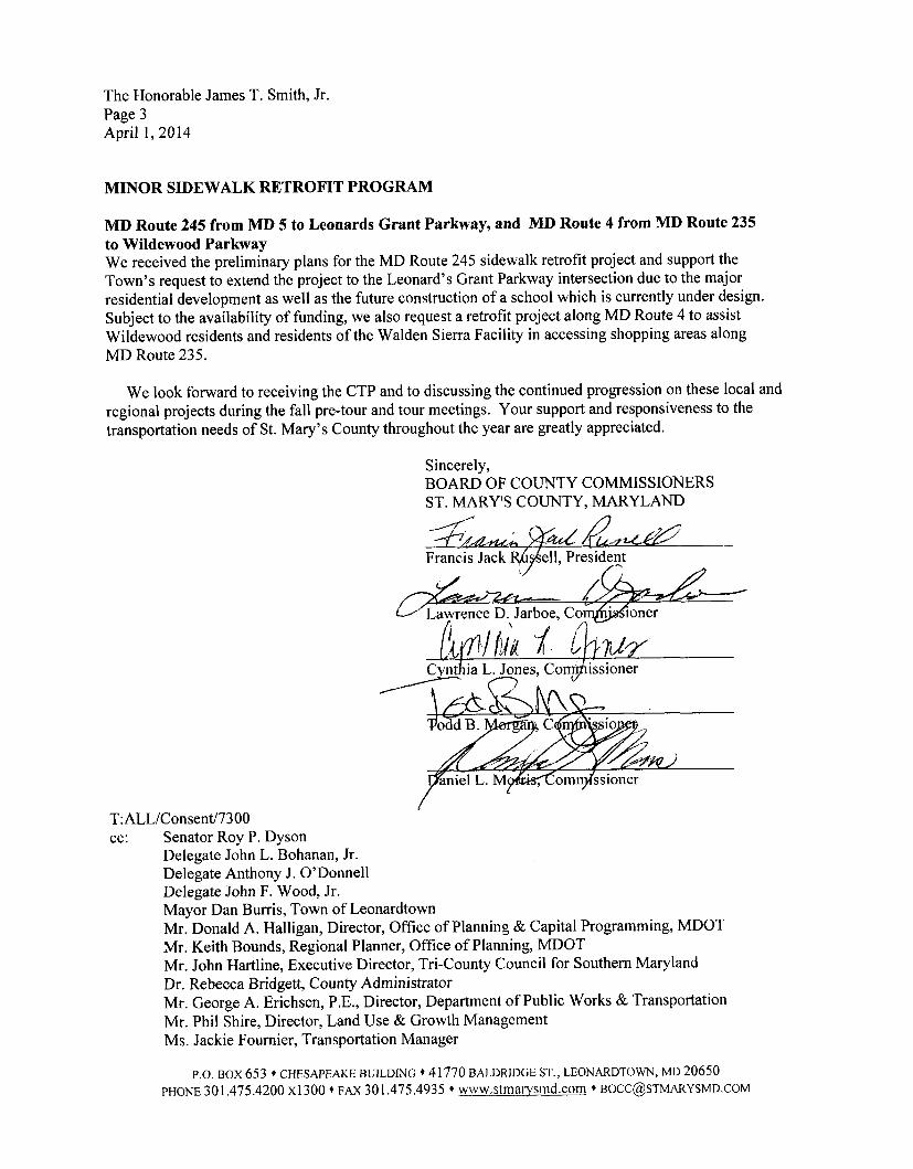
The Honorable James T. Smith, Jr. Page 3 April 1, 2014
MINOR SIDEWALK RETROFIT PROGRAM
MD Route 245 from MD 5 to Leonards Grant Parkway, and MD Route 4 from MD Route 235 to Wildewood Parkway We received the preliminary plans for the MD Route 245 sidewalk retrofit project and support the Town’s request to extend the project to the Leonard’s Grant Parkway intersection due to the major residential development as well as the future construction of a school which is currently under design. Subject to the availability of funding, we also request a retrofit project along MD Route 4 to assist Wildewood residents and residents of the Walden Sierra Facility in accessing shopping areas along MD Route 235.
We look forward to receiving the CTP and to discussing the continued progression on these local and regional projects during the fall pre-tour and tour meetings. Your support and responsiveness to the transportation needs of St. Mary’s County throughout the year are greatly appreciated.
Sincerely, BOARD OF COUNTY COMMISSIONERS ST. MARY‘S COUNTY, MARYLAND
Francis Jack a & e l l , President
9 h i a L A n e s , Comjhissioner
T:ALL/ConsentJ73 00 cc: Senator Roy P. Dyson
Delegate John L. Bohanan, Jr. Delegate Anthony J. O’Donnell Delegate John F. Wood, Jr. Mayor Dan Burris, Town of Leonardtown Mr. Donald A. Halligan, Director, Office of Planning & Capital Programming, MDOT Mr. Keith Bounds, Regional Planner, Office of Planning, MDOT Mr. John Hartline, Executive Director, Tri-County Council for Southern Maryland Dr. Rebecca Bridgett, County Administrator Mr. George A. Erichsen, P.E., Director, Department of Public Works & Transportation Mr. Phil Shire, Director, Land Use & Growth Management Ms. Jackie Fournier, Transportation Manager
P.O. BOX 653 + CHESAPEAKE BUILDING + 41 770 BALDRIDGE ST., LEONARDTOWN, MD 20650 PHONE 301.475.4200 ~ 1 3 0 0 + FAX 301.475.4935 + www.st~naws~nd.com + [email protected]

* BOARD OF COUNTY COMMISSIONERS:
Francis Jack Russell, President Lawrence D. Jarboe, Commissioner
Cynthia L. Jones, Commissioner Todd B. Morgan, Commissioner Daniel L. Morris, Commissioner
i
ST. MARY’S COUNTY GOVERNMENT DEPARTMENT OF PUBLIC WORKS & TRANSPORTATION George A. Erichsen, P. E., Director
Project Questionnaire: Annual Request to Maryland DOT for Project Funding Please provide the following information for each major capital project priority identified
Name of Project: MD 4, Solomons Island Road (Thomas Johnson Bridael
Submitting Jurisdiction:
Location of the project (describe project limits and location; attach map if available and applicable): Between MD 2 and MD 235, includina the Thomas Johnson Bridae and the MD 235 intersection.
Anticipated cost and funding source (approximate, if available): $850M
Description of project purpose and need (up to one paragraph): The purpose of the proiect is to improve existina capacitv and traffic operations. and to increase vehicular, pedestrian and bicvcle safety alona the MD 4 studv corridor while supportinq existina and planned development in the area. MD 4 provides commuters in the area with access to points north. includina the District of Columbia (DC), as well as points south, includina the Naval Air Station Patuxent River. MD 4 is also the main evacuation route for the Calvert Cliffs Nuclear Power Station. The enhancements to the MD 4 studv corridor would improve access, mobilitv. and safetv for local, reaional. and inter-reaional traffic, includina passenqer and transit vehicles. In reaard to the need for the proiect. traffic volumes across the Thomas Johnson Memorial Bridae increased from 12.900 vehicles per dav in 1990 to 27,000 vehicles per dav in the Year 2007. The residential development in the area iust north of Solomons Island has increased substantiallv over the past few years. Over 43 percent of Calvert Countv residents commute outside of the countv. In St. Marv’s Countv, the Naval Air Station Patuxent River now hosts over 21,000 people, includina active-dutv service members, civil-service employees. defense contractor emplovees. and militarv dependents. The total emplovment for St. Marv’s Countv is amroximatelv 49,000 persons, includinq the Patuxent Naval Air Station. In addition to hiah traffic volumes alona northbound and southbound MD 4 durina AM and PM peak periods. the traffic conaestion on Thomas Johnson Memorial Bridae is problematic. lnadeauate shoulder widths alona the bridae cause maior traffic delavs andlor closures durina crashes and maintenance activities for both northbound and southbound traffic on the bridae. This crash potential is exacerbated bv the sub-standard vertical curve at the crest of the bridae. Currentlv. ail maintenance activities on the bridae must be completed durina late nisht to earlv morninq hours to avoid causina maior traffic delavs durina the AM and PM peak traffic hours. In addition to the need for capacitv and safetv improvements, bicvcle and pedestrian access is restricted to the southern portion of the studv area. There is currentlv bicvcle and pedestrian access alona MD 4 south of the bridae in St. Marv’s Countv. but it ends at the bridae. The Thomas Johnson Memorial Bridae does not provide a dedicated bicvclelpedestrian lane.
Is the project contained within the local Metropolitan Planning Organization’s fiscally constrained long-
range transportation plan? Yes Fl NO CI Project located outside of MPO boundaries: The MPO for the Lexinqton ParklSolomons area is currentlv beha formed. and this proiect will be contained within the MPO’s lona ranae transportation plan. This proiect has been desianated as a Top Reqional Prioritv in both the 2008 Southern Marvland Needs Assessment document. as well as the current Reqional Prioritv Letter.
Is the project consistent with the local land use plans? Yes a No 0 Describe specifics on how the project supports the local land use plan goals, objectives and/or policies: This proiect directlv links Calvert Countv with the Lexinaton Park Development District. The additional traffic capacitv will attract additional trips from residential areas of Calvert Countv and points north to the Development District,
P.0. BOX 508 * ARNOLD BUILDING * 44825 ST. ANDREWS CHURCH ROAD CALIFORNIA, MD 20619 PHONE 301.863-8400 * FAX 301.863-8810 * www.stmarysmd.com

therebv enhancina the commercial viabilitv of the MD 235 corridor. The additional capacitv will also help to fuel emplovment in the development district as well as the Naval Air Station Patuxent River.
8) In County priority letter? Yes a No 0
9) Smart Growth status and explanation: This proiect is within the Lexinaton Park Prioritv Fundina Area. The additional traffic capacitv provided bv the proiect will enhance this prioritv fundina area which has the potential of providina more iobs in the PFA.
I O ) Please indicate which of the following Maryland Transportation Plan goals and objectives are served by the requested project investment (mark each goal served by the project and relevant objectives within each goal):
Goal: Quality of Service. Maintain and enhance the quality of service experienced by users of Maryland’s transportation system. a Increase the efficiency of transportation service delivery through the use of systems, processes, partnerships, technologies, and improved service delivery methods. This proiect provides the opportunitv for MDOT to partner with Countv. State, and Federal aqencies to provide an environmentally sensitive, multi-modal facilitv that fosters arowth in the Prioritv Fundina Area, which will position the Naval Air Station Patuxent River as a receivinq facilitv in the upcomina Base Realianment and Closure cvcle. At the present, there are siqnificant delavs on approach to the Thomas Johnson Bridae in both the mornina and afternoon peak hours. The vehicle back-up reaularlv affects travel on MD 235 durina the afternoon peak hour due to excess aueuincl on the northbound bridae approach due to inadeuuate bridqe capacitv. Traffic volumes are proiected to increase to 35,200 vehicles per dav bv 2030, far in excess of two lane bridae capacitv. This proiect will improve the level-of-service dramaticallv. enablina motorists to better predict their travel time.
Objective:
Objective: Maintain and enhance customer satisfaction with transportation services across modes. This proiect will provide an invitina qatewav to St. Marv’s Countv for all those who enter from Calvert Countv. Not onlv will motor vehicle travelers experience less delav, which enhances the travelina experience, but all potential users will be accommodated bv provision of an accessible hikerlbiker trail alona the proiect limits. This trail will connect St. Maw’s Countv’s Three Notch Trail with Solomons Island. which will provide a reaional bicvcle tourism opportunitv. The capacitv increase will allow air commuters from Calvert Countv and points north to arrive at the St. Mary’s Reaional Airport (one mile north of the MD 235/MD 4 intersection) at a more predictable time once commuter air service is established. In addition, the sail boat communitv, which freauentlv uses Solomons Island as a dock, and freuuentlv uses bicvcles as a means of transportation. would be afforded the opportunitv of accessina the reaional airport (and shoppinq opportunities in St. Mary’s) bv bike(throuah use of the proposed hiker biker trail
Objective: Seek to maintain or improve travel time reliability for key transportation corridors and services. This proiect will increase capacitv across the Thomas Johnson Bridue, a kev transportation corridor in the Southern Marvland area. It will also provide an interchanae at the kev intersection alonu MD Route 235 in St. Marvs’ Countv.
Continue to apply enhanced technologies to improve the transportation system and to communicate with the traveling public. This proiect will provide the SHA with the opportunitv to provide an improved weather svstem, video observation svstem, and variable messaae sianina to rapidlv detect and inform travelers of traffic accidents and conaestion, unusual weather events, and other emeraencv situations.
Objective:
If checked, please describe how the project supports the goals and objectives.
Goal: Safety and Security: Enhance the safety of transportation system users and provide a transportation system that is resilient to natural or man-made hazards.
@! Objective: Reduce the number of lives lost and injuries sustained on Maryland’s transportation system. Bv providina a divided hiahwav. and reducina conaestion at the MD 4/MD 235 intersection. the accident rate
P.0. BOX 5 0 8 + ARNOLD BUILDING + 4 4 8 2 5 ST. ANDREWS CHURCH ROAD + CALLFORNIA, MD 20619 PHONE 301 .863-8400 * FAX 301 .863-8810 + www.stmarysmd.com

and severitv will be improved. In addition. the vertical curve at the crest of the bridae is sub-standard and will be replaced bv vertical curve constructed to accommodate the desian speed.
a Objective: Provide secure transportation infrastructure, assets, and operations for the safe movement of people and goods. This proiect will replace the existina two lane Thomas Johnson Bridae span with a new four- lane facilitv. The current bridqe is rated as sufficient, but continuinq maintenance concerns, and a limited desian life of the existina structure, will be addressed bv the new structure. The improved capacitv provided bv the proiect will sumort the current mutual aid aareements between Calvert Countv, St. Marv’s Countv. and Naval Air Station Patuxent River fire departments. These mutual aid aareements presentlv have limited benefit during peak hours due to bridae conaestion. and conqestion at MD 4 and MD 235. In addition to aeneral emeraency support, Naval Air Station Patuxent River provides aircraft accident response to St. Marv’s Reqional Airport. This aircraft accident response would be improved bv the MD 4/MD 235 capacitv improvement. In addition, the proiect would provide improved evacuation caoacitv for weather events, nuclear events, and militarv/terrorism emeraencies. The proiect would also support licensina of a third reactor at Calvert Cliffs nuclear Dower plant.
Goal: System Preservation: Protect and maintain the State’s existing transportation infrastructure and investments.
Objective: Preserve and maintain State-owned or supported roadways, bridges, public transit, rail, bicycle and pedestrian facilities, ports, airports, and other facilities in a state of good repair. As aaina structures reauire more maintenance, this proiect would reduce the number of inspections. and initial maintenance required on the bridae structure. In addition, a wider bridae span would enable the SHA to more easilv conduct bridae inspections as lane closures can be more readilv accomplished.
Goal: Environmental Stewardship: Ensure that the delivery of the State’s transportation infrastructure program conserves and enhances Maryland’s natural, historic, and cultural resources.
a Objective: Limit the impacts of transportation on Maryland’s natural environment through the impact avoidance, minimization, and mitigation. This Droiect will provide the SHA the omortunitv to address the need to protect the natural environment bv addressina the abilitv to avoid impacts. If impacts are unavoidable, thev will be minimized and mitiqation will be provided in accordance with State and Federal Law. a Objective: Employ resource protection and conservation practices in project development, construction, operations, and maintenance of transportation assets. This proiect has a minimal affect on natural, communitv, and historical resources, and natural resources will be protect to the extent practicable durina proiect development, construction, operations, and maintenance.
a Objective: Implement transportation initiatives to mitigate the impacts of climate change and improve air quality. Bv providinq a more efficient transportation infrastructure, less fuel usaae should be incurred per trip, which should improve air aualitv. The bridue structure will be desianed well above the 1 OO-vear flood elevation to mitiaate the potential impact of increased flood elevations due to climate chanae.
Objective: Support broader efforts to improve the health of the Chesapeake Bay, protect wildlife, conserve energy, and address the impacts of climate change. This proiect provides an opportunitv for the SHA to improve environmental aualitv throuah wetland and stormwater manaaement retrofit proiects which will reduce shoreline erosion and improve water aualitv in the proiect area. Enerav will be conserved bv reduced conaestion. The waste material from the existina bridae span can also be used to enhance or create under- water habitat in the Patuxent River or the Chesapeake Bav.
If checked, please describe how the project supports the goals and objectives.
Goal: Community Vitality: communities and quality of life.
Provide options for the movement of people and goods that support
P.0. BOX 508 * ARNOLD BUILDING * 44825 ST. ANDREWS CHURCH ROAD + CALIFORNIA, MD 20619 PHONE 301.863-8400 * FAX 301.863-8810 * www.stmarysmd.com

c’
Objective: Better coordinate transportation investments and land use planning to support the environmental, social and economic sustainability of Maryland’s existing communities and planned growth areas. This proiect serves to connect two existinq communities within the Calvert-St. Marv‘s Metropolitan Planninq Organization (C-SMMPO). Solomons and Lexinqton Park. It will increase vitalitv of the two communities bv eliminatinq peak hour and weekend conaestion. reducinq delavs caused bv frequent bridae inspections and maintenance, and providina a pedestrian/bicvcle linkaae between the communities.
u Objective: Enhance transportation networks and choices to improve mobility and accessibility, and to better integrate with land use. This project will increase the choices in transportation and accessibilitv bv creatinq a bicvclehedestrian linkaae. which will be desiqned as an accessible walkwav. a Objective: Increase and enhance transportation connections to move people and goods within and between activity centers. This proiect will help to move people and qoods within the C-SMMPO. as well as two established communities (Solomons and Lexinqton Park) within the MPO. bv increasina capacitv, providinq an accessible bicvcle/pedestrian linkaae. and providina a bridqe structure which will have a reduced maintenance schedule.
Goal: Economic Prosperity: Support a healthy and competitive Maryland economy.
Objective: Improve the movement of freight and support growth in the flow of goods within and through Maryland. This proiect will improvement the movement of freiaht as well as the flow of aoods throuah Marvland bv providinq for additional truck capacitv for freiqht and qoods moved bv trucks into the Lexinqton Park and Leonardtown development districts from the north, and for qoods movina in to lower Calvert Countv from the south. The capacitv improvement will allow shippers more flexibilitv in schedulinq truck deliveries. since the bridqe bottleneck will be eliminated. Delavs will be qreatlv reduced for this flow of aoods into both counties. In addition. the heiqht of the bridqe structure will allow for the movement of freiqht into both counties bv water.
Objective: Facilitate opportunities for growth in jobs and business across the State. This Droiect is necessarv to preserve and enhance the Naval testinq presence in Southern Marvland. The Naval Air Station Patuxent River is vital for the economv of Southern Marvland. and access to the Base is one of the primary measures the Base Realianment and Closure Committee considers when decidinq the future of a facilitv. The proiect will helD to assure the continued viabilitv of the Base, and its ancillarv uses. It will also support additional growth that is necessarv to diversifv the economv of Southern Marvland. in the event of a reduction of militarv fundina. In addition. a new proposal for a cruise ship terminal at the Solomons Recreation Annex (north of the bridae) will be enabled bv increased traffic capacitv for customers to arrive at the ship on time, as well as a bridqe heiqht conducive to allow passaqe of the cruise ships.
If checked, please describe how the project supports the goals and objectives.
11) Additional Comments / Explanation:
S\JGroeger:CIP Questionnaire-Thomas Johnson Bridge @I 5.doc
P.0. BOX 508 * ARNOLD BUILDING * 44825 ST. ANDREWS CHURCH ROAD CALIFORNIA, MD 20619 PHONE 301.863-8400 FAX 301.863-8810 * www.stmarysmd.com

LOCATION MAP: MD 4 PROJECT
i . !
!
-. .
\
. . . . . .
I I
- !
$ 1
BOARD OF COUNTY COMMISSIONERS: Francis Jack Russell, President
Lawrence D. Jarboe, Commissioner Cynthia L. Jones, Commissioner Todd 6. Morgan, Commissioner Daniel L. Morris, Commissioner
ST. MARY’S COUNTY GOVERNMENT DEPARTMENT OF PUBLIC WORKS & TRANSPORTATION George A. Erichsen, P. E., Director
Project Questionnaire: Annual Request to Maryland DOT for Project Funding Please provide the following information for each major capital project priority identified
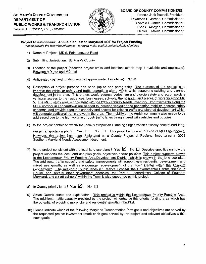
Name of Project: MD 5, Point Lookout Road
Submitting Jurisdiction: St. Maw’s Countv
Location of the project (describe project limits and location; attach map if available and applicable): Between MD 243 and MD 245
Anticipated cost and funding source (approximate, if available): $70M
Description of project purpose and need (up to one paragraph): The uuruose of the uroiect is to imurove the vehicular safetv and traffic operations alona MD 5, while suuuortina existina and ulanned develoument in the area. This uroiect would address pedestrian and bicvcle safetv and accommodate vehicular access to the residences. businesses, schools, the hospital, and places of worshiu alona MD 5. The MD 5 studv area is consistent with the 2007 Hiahwav Needs Inventorv. Improvements alonq the MD 5 corridor in Leonardtown are needed to increase vehicular and pedestrian mobilitv, address safetv concerns, and provide adequate capacitv and access for existina traffic and ulanned develoument which will qenerate additional traffic qrowth in the area. The mobilitv of the Amish communitv also needs to be addressed due to the hiah volume throuqh traffic lanes beina shared with vehicles and buaaies.
Is the project contained within the local Metropolitan Planning Organization’s fiscally constrained long-
range transportation plan? Yes 0 No 0 This proiect is located outside of MPO boundaries. However, the uroiect has been desianated as a Countv Proiect of Reaional Importance in 2008 Southern Marvland Needs Assessment document.
Is the project consistent with the local land use plans? Yes a No Describe specifics on how the project supports the local land use plan goals, objectives and/or policies: This uroiect suu~orts arowth in the Leonardtown Prioritv Fundinq Area/Develoument District, which is shown in the land use ulan. The additional traffic caoacitv and safetv improvements will supuort new residential development and mixed use qrowth, as well as encourage redevelopment of the Town Center within the Town of Leonardtown. The mission of public lands [St. Maw’s Hosuital, the Governmental Center, the Court House. and several other qovernment aqencies. the Port of Leonardtown, Colleqe of Southern Marvland, and six (6) schools) within the Town is also suuuorted bv this uroiect.
In County priority letter? Yes IZl NO
Smart Growth status and explanation: This woiect is within the Leonardtown Prioritv Fundina Area. The additional traffic cauacitv urovided bv the uroiect will enhance this urioritv fundina area which has the potential of urovidinq more iobs and residential arowth in the PFA.
10) Please indicate which of the following Maryland Transportation Plan goals and objectives are served by the requested project investment (mark each goal served by the project and relevant objectives within each goal):
1

Goal: Quality of Service. Maintain and enhance the quality of service experienced by users of Maryland’s transportation system.
Increase the efficiency of transportation service delivery through the use of systems, processes, partnerships, technologies, and improved service delivery methods. At the present, there are delavs on approach to the MD 245 and MD 243 intersections at either end of the proiect durina the mornina and afternoon peak periods. In the 2030 desiqn vears, the proiected level-of-service at four of the five studied intersections will deteriorate to level-of-service ‘F’ without improvements, which this proiect will correct. The proiect will reduce delavs for Town residents who travel to the three (31 park and ride lots to the north of the Town. Althouah MD 5 is desianated as a bicvcle route, bicvcle travel is discouraaed due to the need to share a hiah speed, hiah volume travel lane with vehicles. Some of these bicvcle riders mav wish to access the park and ride lot at the SHA salt dome about 1 mile north of the proiect. The proiect will also make travel times for local school and transit busses more predictable, which will allow the busses to arrive on-time to the schools/bus stops within the Town.
Objective:
a Objective: Maintain and enhance customer satisfaction with transportation services across modes.- proiect will provide an invitinq aatewav to the Town of Leonardtown for all those who enter the Development District from the north. Not onlv will motor vehicle travelers experience less delav and enhanced safety features, which enhances the travelina experience, but all potential users will be accommodated bv provision of sidewalk and as well as bicvcle and Amish carriaae accommodations alona the Droiect limits.
Objective: Seek to maintain or improve travel time reliability for key transportation corridors and services. This proiect would improve travel time reliabilitv alonq the MD Route 5 corridor, which is critical for commuters to the Patuxent River Naval Air Station and ancillarv emplovment, as well as the businesses and residents of the Town of Leonardtown.
u Continue to apply enhanced technologies to improve the transportation system and to communicate with the traveling public. This proiect will provide the SHA with the opportunitv to provide an improved weather svstem, video observation svstem, and variable messaae sianina to rapidlv detect and inform travelers of traffic accidents and conaestion, unusual weather events, and other emeraencv situations. If checked, please describe how the project supports the goals and objectives.
Objective:
Goal: Safety and Security: Enhance the safety of transportation system users and provide a transportation system that is resilient to natural or man-made hazards.
Objective: Reduce the number of lives lost and injuries sustained on Maryland’s transportation system. Four-lane, undivided roadwavs have the hiahest accident rate in the State. This roadwav has a hiah accident rate throuahout the proiect corridor. Bv providina left and riaht turn lanes and traffic control sianals where approwiate. the accident rate and severitv will be minimized, includina accident potential for pedestrians, bicvclists, and carriaaes.
Objective: Provide secure transportation infrastructure, assets, and operations for the safe movement of people and goods. This Droiect will rehabilitate the deteriorated pavement section and drainaae svstem. These uparades will reduce the freauencv of unscheduled maintenance, which will minimize traffic disruption and periodic floodina. The improved capacitv provided bv the proiect will enable a safer and more rapid response bv emerqencv vehicles from the Leonardtown State Police barracks, the St. Marv’s Countv Sheriff’s Department, and fire and rescue services located within the Town to points north, as well as reducina rescue sauad(and personal vehicle) travel time to St. Marv’s Hospital (with its main entrance on MD 5). Since MD 5 is an evacuation route for St. Maw’s and Calvert Counties for maior storms, nuclear emeraencies for Calvert Cliffs Nuclear Power Plan, and militaw/terrorism emeraencies for Naval Air Station Patuxent River. this Droiect would speed the evacuation process.
Goal: System Preservation: Protect and maintain the State’s existing transportation infrastructure and investments.
2

a Objective: Preserve and maintain State-owned or supported roadways, bridges, public transit, rail, bicycle and pedestrian facilities, ports, airports, and other facilities in a state of good repair. As aaina structures rewire more maintenance. this proiect would reduce the road maintenance needed for this roadwav. In addition. a wider road section would enable the SHA to more easilv conduct road and bridae inspections as lane closures can be more readilv accomplished.
Goal: Environmental Stewardship: Ensure that the delivery of the State’s transportation infrastructure program conserves and enhances Maryland’s natural, historic, and cultural resources.
a Objective: Limit the impacts of transportation on Maryland’s natural environment through the impact avoidance, minimization, and mitigation. This proiect will provide the SHA the omortunitv to address the need to protect the natural environment bv addressina the abilitv to avoid impacts. If impacts are unavoidable, they will be minimized and mitiaation will be provided in accordance with State and Federal Law. a Objective: Employ resource protection and conservation practices in project development, construction, operations, and maintenance of transportation assets. This proiect has a minimal affect on natural, community, and historical resources, and natural resources will be protect to the extent practicable durina proiect development. construction, operations. and maintenance.
a Objective: Implement transportation initiatives to mitigate the impacts of climate change and improve air quality. Bv providina a more efficient transportation infrastructure, less fuel usaae should be incurred Per trip, which should improve air aualitv. The bridae structure at McIntosh Run should be desianed above the 100-vear flood elevation to mitiaate the potential impact of increased flood elevations due to climate chanqe. If this is not possible, the structure will be raised to the extent practical, which will minimize the frequencv and duration of floodina.
a Objective: Support broader efforts to improve the health of the Chesapeake Bay, protect wildlife, conserve energy, and address the impacts of climate change. This proiect provides an opportunitv for the SHA to improve environmental aualitv throuah wetland and stormwater manaqement retrofit proiects which will reduce erosion and improve water uualitv in the proiect area. Enerav will be conserved bv reduced conaestion.
If checked, please describe how the project supports the goals and objectives.
Goal: Community Vitality: communities and quality of life.
Provide options for the movement of people and goods that support
a Objective: Better coordinate transportation investments and land use planning to support the environmental, social and economic sustainability of Maryland’s existing communities and planned growth areas. This proiect supports Smart Growth in St. Marv’s Countv, as it is located within the Leonardtown PFA. It also supports the Base Realianment and Closure process. and will serve to attract more iobs to Naval Air Station Patuxent River, which reinforces arowth within both the Leonardtown and Lexinqton Park PFA’s. This Base has an extensive travel demand proaram which reduces and spreads the travel demand to make the most efficient use of the transportation network possible. Even so, the success of the Base and the surroundina area has made the development district a trip attractor. and additional traffic capacitv is needed for the roads servinq the Base in the near future. a Objective: Enhance transportation networks and choices to improve mobility and accessibility, and to better integrate with land use. This proiect will increase the choices in transportation and accessibilitv by creatina bicvcle and pedestrian linkaaes. The sidewalk will be desianed as an accessible walkwav to serve residents and business in the area. a Objective: Increase and enhance transportation connections to move people and goods within and between activity centers. This proiect is necessarv to improve access not onlv to the Lexinaton Park PFA. but also to the Leonardtown PFA and Naval Air Station Patuxent River. MD 5 connects northern St. Marv’s Countv to the Lexinaton Park PFA for commuters from the Northern Countv, as well as Charles Countv and Virainia. The Naval Air Station Patuxent River is vital for the economv of Southern Marvland, and access to the Base is
3

one of the primarv measures the Base Realiqnment and Closure Committee considers when decidina the future of a facilitv.
Goal: Economic Prosperity: Support a healthy and competitive Maryland economy.
a Objective: Improve the movement of freight and support growth in the flow of goods within and through Maryland. This proiect will improvement the movement of freiaht as well as the flow of aoods throuah Marvland bv providinq for additional truck capacitv for freiaht and qoods moved bv trucks into the Leonardtown and Lexington Park areas from the south. and the Leonardtown development districts from the north. The caeacitv improvement will allow shippers more flexibilitv in schedulina truck deliveries, since the intersection bottleneck will be eliminated.
Objective: Facilitate opportunities for growth in jobs and business across the State. . This proiect is necessarv to improve access not onlv to the Leonardtown PFA, but also to the Lexinqton Park PFA and Naval Air Station Patuxent River. MD 5 connects northern St. Marv’s Countv to the Lexinaton Park PFA for commuters from the Northern Countv, as well as Charles Countv and Virqinia. The Naval Air Station Patuxent River is vital for the economv of Southern Marvland, and access to the Base is one of the prirnarv measures the Base Realianment and Closure Committee considers when decidinq the future of a facilitv. The proiect will help to assure the continued viabilitv of the Base.
If checked, please describe how the project supports the goals and objectives.
11) Additional Comments / Explanation:
S:WGROEGER\Project Questionnaire-MD 5 (3-21-1 2)
4

I
I
LOCATION MAP: MD 5 PROJECT
I
!

BOARD OF COUNTY COMMISSIONERS: Francis Jack Russell, President
Lawrence D. Jarboe, Commissioner Cynthia L. Jones, Commissioner Todd B. Morgan, Cornmissioner Daniel L. Morris, Commissioner
ST. MARY’S COUNTY GOVERNMENT
PUBLIC WORKS & TRANSPORTATION George A. Erichsen, P. E., Director
DEPARTMENT OF / i
Project Questionnaire: Annual Request to Maryland DOT for Project Funding Please provide the following information for each major capital project priority identified
1) Name of Project: MD 5, Point Lookout Road
2) Submitting Jurisdiction: St. Marv’s County
3) Location of the project (describe project limits and location; attach map if ava i l t id and applicable Between MD 246 and MD 249
4) Anticipated cost and funding source (approximate, if available): $48M
I.
5) Description of project purpose and need (up to one paragraph): The purpose of the proiect is to improve the vehicular safetv and traffic operations alonq MD 5, while supportinq existins and planned development in the area. This proiect would improve traffic flow in the southern portion of St. Marv’s Countv, address pedestrian and bicvcle safetv and accommodate vehicular access to the residences, businesses, schools, and places of worship alonq MD 5. The MD 5 studv area is consistent with the 2007 Hiqhwav Needs Inventorv. Improvements alonq the MD 5 corridor. This proiect would support access to Naval Air Station Patuxent River, and would improve emerqencv evacuation from Southern Calvert Countv and St. Marv’s Countv.
6) Is the project contained within the local Metropolitan Planning Organization’s fiscally constrained long-
range transportation plan? Yes a No 0 Project located outside of MPO boundaries: The MPO for Southern Marvland is the Tri-Countv Council. This proiect has been desiqnated as a County Proiect of Reqional Importance in 2008 Southern Marvland Needs Assessment document.
7) Is the project consistent with the local land use plans? Yes No 0 Describe specifics on how the project supports the local land use plan goals, objectives andlor policies: This proiect s u ~ ~ o r t s growth in the Lexinqton Park and Leonardtown Prioritv Fundins Area/Development Districts, which is shown in the land use plan. The additional traffic capacity and safetv improvements will sup~ort new residential development and mixed use qrowth, as well as encouraqe redevelopment of the Town Center within the Town of Leonardtown, bv providinq a critical link between the two development districts. The mission of two (2) schools (Kinqs Christian Academy and Little Flower School). one church, and a post office within the proiect limits would also supported bv this Droiect.
8) In County priority letter? Yes a No 0
9) Smart Growth status and explanation: 0.63 miles of the total 1.45 mile project length is within the Lexinqton Park Prioritv Fundinq Area(PFA). The proiect provides a connection to the Callawav Village Center, and provides a partial connection to the Leonardtown PFA. The additional traffic capacitv provided bv the proiect will enhance the PFA’s, which has the potential of providinq more iobs and residential qrowth, primarilv within the Lexinqton Park PFA.
IO) Please indicate which of the following Maryland Transportation Plan goals and objectives are served by the requested project investment (mark each goal served by the project and relevant objectives within each goal):
Goal: Quality of Service. Maryland’s transportation system.
Maintain and enhance the quality of service experienced by users of
1

a Increase the efficiency of transportation service delivery through the use of systems, processes, partnerships, technologies, and improved service delivery methods. At the present, there are delavs on approach to the MD 246 and Flat Iron Road/MD 471 intersections durina the morninq and afternoon peak periods. In the 2025 desian year. the proiected level-of-service at the MD 5 /MD 471 intersection will deteriorate to level-of-service ‘F’ in both the mornina and afternoon peak hours without improvements. which this proiect will correct. Althouqh MD 5 is desiclnated as a bicvcle route, bicvcle travel is discourased due to the need to share a hiqh speed. hiah volume travel lane with vehicles. The proiect limits serve a local bus route known as the Route 5 Express. This route provide transit services between the Leonardtown and Lexinqton Park PFAs. The proiect will make travel times for local school and transit busses more predictable. which will allow the busses to arrive on-time to the schools/bus stops within the proiect, and will make transit riders experience more predictable travel times between Leonardtown and Lexinqton Park.
Objective:
Objective: Maintain and enhance customer satisfaction with transportation services across modes.- proiect will provide an invitinq natewav to the Lexinqton Park Development District from the north. Not onlv will motor vehicle and transit travelers experience less delav and enhanced safetv features, which enhances the travelinq exDerience, but all potential users will be accommodated bv provision of sidewalk and as well as bicvcle accommodations alonq the proiect limits.
a Objective: Seek to maintain or improve travel time reliability for key transportation corridors and services. This proiect would improve travel time reliabilitv alonq the LID Route 5/MD Route 246 corridor. which is critical for commuters to the Patuxent River Naval Air Station and ancillarv emplovment.
a Continue to apply enhanced technologies to improve the transportation system and to communicate with the traveling public. This proiect will provide the SHA with the opportunitv to Provide an improved weather svstem, video observation svstem, and variable message sianinn to rapidlv detect and inform travelers of traffic accidents and conqestion, unusual weather events, and other emerqencv situations. If checked, please describe how the project supports the goals and objectives.
Goal: Safety and Security: Enhance the safety of transportation system users and provide a transportation system that is resilient to natural or man-made hazards.
Objective:
a Objective: Reduce the number of lives lost and injuries sustained on Maryland’s transportation system. The accident rate within the limits of the proiect is hinher than State averaqes, particularlv at the MD 5 intersection with MD 471/Flat Iron Road. The proiect will improve safetv bv reducina conaestion, improvinq traffic oDerations, and bv providinq a median between MD 249 and MD 471/Flat Iron Road. The accident potential for pedestrians and bicvcles will also be reduced bv providinq facilities for these movements.
rn Objective: Provide secure transportation infrastructure, assets, and operations for the safe movement of people and goods. This Proiect will rehabilitate the deteriorated pavement section and drainaae svstem. These upqrades will reduce the frequency of unscheduled maintenance. which will minimize traffic disruption. The periodic maior floodinq which occurs at St. Marv’s River shoyLd also be addressed bv this Droiect. The improved capacitv provided bv the proiect will enable a safer and more rapid response bv emergency vehicles from the Lexinqton Park area to points north and will reduce rescue squad(and personal vehicle) travel time to St. Marv’s Hospital in Leonardtown. Since MD 5 is an evacuat&m route for St. Marv’s and Calvert Counties for maior storms, nuclear emerqencies for Calvert Cliffs Nuclear Power Plan. and militarv/terrorism emerqencies for Naval Air Station Patuxent River, this project would speed the evacuation process.
Goal: System Preservation: Protect and maintain the State’s existing transportation infrastructure and investments.
Objective: Preserve and maintain State-owned or supported roadways, bridges, public transit, rail, bicycle and pedestrian facilities, ports, airports, and other facilities in a state of good repair. . As aaina structures require more maintenance, this proiect would reduce the road maintenance needed for this roadwav. In addition, a wider road section would enable the SHA to mor2 ezsilv conduct road and bridqe inspections as lane closures can be more readilv accomplished.

Goal: Environmental Stewardship: Ensure that the delivery of the State’s transportation infrastructure program conserves and enhances Maryland’s natural, historic, and cultural resources.
a Objective: Limit the impacts of transportation on Maryland’s natural environment through the impact avoidance, minimization, and mitigation. This proiect will provide the SHA the opportunitv to address the need to protect the natural environment bv addressinq the abilitv to avoid impacts. If impacts are unavoidable, they will be minimized and mitiaation will be provided in accordance with State and Federal Law. a Objective: Employ resource protection and conservation practices in project development, construction, operations, and maintenance of transportation assets. msgro iect has a minimal affect on natural, community, and historical resources. and natural resources wi!l be protect to the extent practicable durina proiect development. construction, operations, and maintenance.
a Objective: Implement transportation initiatives to mitigate the impacts of climate change and improve air quality. Bv providinq a more efficient transportation infrastructure, less fuel usaqe should be incurred per trip, which should improve air qualitv. The bridge structure should be desiqned above the 100-vear flood elevation to mitiqate the potential impact of increased flood elevations due to climate chanae. If this is not possible, the structure will be raised to the extent practical, which will minimize the frequencv and duration of floodina.
a Objective: Support broader efforts to improve the health of the Chesapeake Bay, protect wildlife, conserve energy, and address the impacts of climate change. This proiect provides an opportunitv for the SHA to improve environmental qualitv throuah wetland and stormwater rnanaaement retrofit Droiects which will reduce erosion and improve water qualitv in the proiect area. Enerqv will be conserved bv reduced conqestion.
If checked, please describe how the project supports the goals and objectives.
Goal: communities and quality of life.
Community Vitality: Provide options for the movement of people and goods that support
a Objective: Better coordinate transportation investments and land use planning to support the environmental, social and economic sustainability of Maryland’s existing communities and planned growth areas. This proiect supports Smart Growth in St. Maw’s Countv, as it is located partiallv within the Lexinqton Park PFA. It also supports the Base Realiqnment and Closure process, and will serve to attract more iobs to Naval Air Station Patuxent River, which reinforces arowth within both the Leonardtown and Lexinqton Park PFAs. This Base has an extensive travel demand proqram which reduces and spreads the travel demand to make the most efficient use of the transportation network possible. Even so, the success of the Base and the surroundinq area has made the development district a trip attractor, and additional traffic capacity is needed for the roads servinq the Base in the near future. a Objective: Enhance transportation networks and choices to improve mobility and accessibility, and to better integrate with land use. This uroiect will increase the choices in transportation and accessibilitv bv creatinq bicycle and pedestrian linkaqes. The sidewa!k will be desiqned as an accessible walkwav to serve residents and business in the area.
Objective: Increase and enhance transportation connections to move people and goods within and between activity centers. This proiect is necessary to improve access not onlv to the Lexinqton Park PFA. but also to the Leonardtown PFA and Naval Air Station Patuxent River. MD 5 connects northern St. Maw’s County to the Lexinqton Park PFA for commuters from the Northern County, as well as Charles County and Virqinia. The Naval Air Station Patuxent River is vital for the economv of Southern Mawland, and access to the Base is one of the primary measures the Base Realianment and Closure Committee considers when decidinq the future of a facilitv.
Goal: Economic Prosperity: Support a healthy and competitive Maryland economy.
3

a Objective: Improve the movement of freight and support growth in the flow of goods within and through Maryland. This proiect will improvement the movement of freiqht as well as the flow of qoods throuqh Marvland by providinq for additional truck capacitv for freiqht and qoods moved bv trucks into the Lexinqton Park area from the south, and the Leonardtown development districts from the north. The capacitv improvement will allow shippers more flexibilitv in schedulinq truck deliveries, since the intersection bottleneck will be eliminated. a Objective: Facilitate opportunities for growth in jobs and business across the State. This Droiect is necessarv to preserve and enhance the Naval testinq presence in Southern Maryland. The Naval Air Station Patuxent River is vital for the economy of Southern Marvland, and access to the Base is one of the primary measures the Base Realianment and Closure Committee considers when decidinq the future of a facilitv. The proiect will help to assure the continued viabilitv of the Base, and its ancillarv uses. It will also s u ~ ~ o r t additional qrowth that is necessary to diversifv the economy of Southern Marvland. in the event of a reduction of militarv fundinq.
If checked, please describe how the project supports the goals and objectives.
11) Additional Comments / Explanation:
S:UGROEGER\Project Questionnaire-MD 5 from MD 246 to MD 249 fy l5
4

.. I
i
Location Map MD 5 from MD 246 to MD 249
: 1”=2000’
. I I I